
1
Introduction
INTENT AND OUTLINE OF THIS REPORT
Geoscience data and collections1 (e.g., cores, cuttings, fossils, geophysical tapes, paper logs, rocks) are the foundation of basic and applied geoscience research and education, and underpin industry programs to discover and develop domestic natural resources to fulfill the nation’s energy and mineral requirements. Geoscience data and collections record the history of processes that operate on the Earth today and in the past and provide insights that lead to improved prediction of potential hazards, both immediate and long term. The geoscience community has amassed an enormous wealth of data and collections, most of which remains potentially useful and would be costly to replace, and much of which is irreplaceable. The diversity and quantity of these geoscience data and collections continue to expand, and as they have, so has need for space to support the preservation of and access to those needing preservation.
Because the ability to preserve and maintain geoscience data and collections has not kept pace with the generation and acquisition of new data through the decades (as demonstrated within this report through examples of data loss and lack of space), the nation is now in danger of irretrievably losing valuable and unique geologic records. The United States has not planned for the large amount of geoscience data that merits preservation. Yet geoscience data and collections are a trove of untapped resources awaiting scientists, engineers, educators, and policy makers who can consolidate and use the information. It is an appreciation of these issues that led a broad range of government agencies and other organizations (American Association of Petroleum Geologists, American Association of Petroleum Geologists Foundation, American Geological Institute, Department of Energy–Fossil Energy, Department of Energy–Yucca Mountain, Geological Society of America, National Science Foundation, Paleontological Society, Petrotechnical Open Software Corporation, Schlumberger, Ltd., Smithsonian Institution, and U.S. Geological Survey) to support this study. The statement of task to the study committee is given in Sidebar 1-1.
This report builds the reader’s understanding of the utility of: geoscience data and collections; why the data and collections were acquired initially, why many remain useful, and what should be kept (item 1 of the committee’s charge); the magnitude of physical (as opposed to digital) geoscience data and collections that exist and where they currently reside (item 2 of the committee’s charge); and the difference between space available and space needed to retain and properly use many of these geoscience data and collections. These topics are covered in the first three chapters of the report. Chapter 4 demonstrates the necessary steps in preserving geoscience data and collections (item 3 of the committee’s charge), and Chapter 5 examines potential roles of the public and private sectors in preservation (item 4 of the committee’s charge), and maps out a national strategy for effectively managing geoscience data and collections (the overall goal of the committee’s charge).
From the outset, it is important to understand what is meant by the term preservation. Preservation involves a number of interrelated processes: evaluation of what should be kept, acquired, or assimilated; organization and maintenance, both of the physical samples, and of supporting information, or metadata; making users aware of geoscience data and collections; making geoscience data and collections acces-
|
1 |
Technical terms are defined in Appendix E and highlighted upon first occurrence in the report. The committee defines geoscience as the collective disciplines of the geological sciences, including engineering geology, geobiology, geochemistry, geohydrology, geophysics, sedimentology, and stratigraphy, among other solid-Earth-based subdisciplines. This definition contrasts with Earth science, which the committee defines as the collective disciplines of whole-Earth study, including atmospheric science, ocean science, and geoscience. Geoscience collections are groupings of individual geoscience items that may be related by sample type, geographic location, or scientific or applied interests. |
|
SIDEBAR 1-1 Statement of Task The preservation of geoscience data (e.g., cores, cuttings, maps, paper reports, digital dataa) is becoming a critical issue for federal agencies, academic researchers, museums, institutes, and industry. This study will:
The overall goal of the study is to develop a comprehensive strategy for managing geoscience data in the United States.
|
sible to users; and making samples and data useful and of sufficient quality and validity to be believable. A successful strategy for managing geoscience data and collections in the United States must address all components. First and foremost, however, these components rest on a single, critical element—good accompanying documentation2 for the data and collections.
Proper curation of geoscience data and collections is more efficient and less redundant than repeatedly re-collecting the samples. Archiving costs3 summed over many decades may approach reacquisition costs, but the value of ready access to data and collections (for hazards response and other unanticipated uses, education, and academic and commercial research) is only realized if these data and collections are preserved. Additionally, existing collections have been assembled over many years using samples from the same sites or regions. These collections usually are much larger and more representative than collections assembled by a single expedition. Lastly, re-collection of physical samples often requires physical disturbance, which in densely populated, reclaimed, or pristine areas, could make access and collection undesirable.
WHAT ARE GEOSCIENCE DATA AND COLLECTIONS AND WHY ARE THEY IMPORTANT?
Geoscience data and collections come in many shapes and forms (Figures 1-1 and 1-2; Appendix D). Whether they are fossils, rocks, or cylindrical cores of rock, sediment, or ice, these geological materials record chapters of Earth’s history.4 Taken together, these chapters constitute a library that federal and state agencies, university researchers, and private companies use daily to understand the physical world— past, present, and future. This library provides invaluable and, in many cases, unique information with scientific, health, safety, commercial, and educational benefits, many of which are explored in this section. Each time a geological sample or piece of data is allowed to deteriorate, or is damaged, misplaced, or thrown away without assessing its merits, the information it contains and the knowledge it represents are lost. Multiplying this loss over and over again is
|
2 |
Good accompanying documentation means adequate supporting information about the geoscience data and collections. What is adequate for one purpose may be inadequate for another. However, in general, documentation has to be more complete for legal or research purposes than for teaching and display purposes. Documentation includes information about age, location, depth, originator, and date acquired. |
|
3 |
In one example, the replacement cost per foot of oil industry core currently is between $550 and $1,200, compared to an average annual storage cost of $0.33 to $0.66 per foot (Emily Stoudt, ChevronTexaco, personal communication, 2001). For further discussion of this point see Montgomery (1999). |
|
4 |
Chapter 3 describes in detail the types of geologic data and collections, who collects them, and why. |
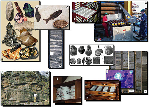
FIGURE 1-1 Examples of geoscience samples and collections that provide the underpinnings for geoscience data. A) Geological outcrop. Such exposures provide a wealth of geoscience data and collections to the geoscience community. B) Rock and mineral specimens. C) Fossil fish and trilobite. D) Slabbed piece of core (about 4 inches across) from an industry drill well. E) Foraminifera microfossils. F) Tray of samples reposited at Alberta Energy and Utilities Board–Core Research Centre. The samples are drill cuttings, required to be submitted under Oil and Gas Conservation Regulation (Oil and Gas Conservation Act–Alberta) for wells that fit the criteria for this requirement. G) Sections of core from an industry drill well being unloaded for processing. H) Lower halves of typical box (approximately 3 feet long) of slabbed industry core. I) Microscopic fluid inclusions in potential reservoir rock for oil. J) Pictures of tapes containing data from boreholes—stored in a field computing center. K) Storage of digital audio tape (DAT) tapes containing borehole data. Original tapes and their backups are stored in the same drawer. SOURCE: A-I: ExxonMobil Upstream Research Company; F: Guenter Wellmann, Alberta Core Repository, Calgary; J and K: Phillipe Theys, Schlumberger, Ltd., Sugarland, Texas.
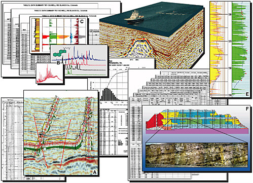
FIGURE 1-2 Examples of geoscience data. Tables and charts that underlie these images are representative of tabular geoscience data also at risk. Many of these data still reside in paper form or on old tapes. A) Two-dimensional seismic section with well logs plotted on the seismic data. B) Gas chromatograph plots derived from analyses of oil samples. C) Down-hole profile of hydrocarbon content of fluid inclusions. D) Three-dimensional seismic data cube. E) Well-log plot from an industry drill well showing rock type and possible hydrocarbon-rich layers. F) Outcrop of sedimentary rocks and a geological cross section (upper image) derived from data collected at that outcrop SOURCE: ExxonMobil Upstream Research Company.
analogous to the destruction or loss of irreplaceable books in a library. Such losses have the potential to result in analyses, interpretations, and policies that reach incomplete, poorly supported, or even erroneous conclusions. Just as all books in any given library are not used all the time by all people, all samples and repositories of geoscience data and collections may not experience uniformly high usage. “It is a characteristic of this stuff that there are long periods of low interest and short bursts of high interest.” (William Fisher, Bureau of Economic Geology, University of Texas at Austin, personal communication, 2001).
“Building large collections of crucial source material has remained a way to ensure the vitality of knowledge” (Montgomery, 1999, p. 84). New ideas almost always are built from previously collected information. “We see in the rocks what we know,” says Robert Weimer, professor emeritus of the Colorado School of Mines (personal communication, 2001), and as time goes by we know more. In this way, old core can produce new knowledge. Existing geoscience data and collections may be viewed both with new eyes and with new technologies. New analytical devices or techniques may be applied to previously collected cores and other samples. New computer techniques may be applied to existing data.
Hazard Assessment
Geoscience data and collections are important resources for assessment, monitoring, and design of response strategies for many natural hazards, including volcanoes, earthquakes, landslides, and coastal erosion. Assessing the relative hazard potential of these natural phenomena relies upon one of the most fundamental axioms of geology: the present is the key to the past and the past is the key to the future. Whether determining the frequency of volcanic ash falls or landslides, the extent and rate of shoreline erosion, or the history of earthquakes in a region, it is critical to have access to geoscience data and collections that record the history of these events (Figure 1-3).
Time is critical in hazards response. Time wasted in recollecting data, tracking down lost data, or trying to upgrade existing data results in delayed response after hazardous events. Response adequacy and timeliness are directly related to data quality, quantity, and accessibility. For instance, inaccurate mine maps and inadequate site characterization have contributed to a number of coal waste impoundment failures over the past two decades (NRC, 2002, p. 29). Complete, accessible, and timely data would have saved lives and enormous sums of money. The tragedy is that many of these data undoubtedly existed but were lost, discarded, or forgotten.
Human activity requires massive amounts of energy (coal, gas, coal, nuclear, oil), minerals (aluminum, copper, iron, magnesium, iron, zinc), and water, as well as moving massive amounts of earth materials and disposing of massive amounts of waste. Screening sites for municipal, toxic, or nuclear waste disposal, designing and siting highways, bridges, dams, utility lines, and virtually every building is highly dependent upon the availability of, and access to, geoscience data and collections. Planners must have timely, complete, and well-documented information on geological formations, groundwater flow, seismic frequency and magnitude, and geotechnical properties of the material on which they build. Multiple core and data collections provide designers and engineers with material and datasets that are generally larger, better, and more cost-effective than can be constructed from a single new collection (assuming that building a new collection is even possible).
Basic and Applied Scientific Research
Geoscience data and collections are fundamental tools for assessing Earth’s resources and for understanding Earth’s geological past and the history of life. They help us address some of our most basic questions: How did Earth form? How old is Earth? How did life develop on Earth? Where did energy and mineral resources form? Why and how often do big earthquakes occur? How can we safely dispose of waste? Such investments in applied and basic research contribute to our immediate economic well-being (see Jones and Williams, 1998), as well as to the quality of our lives.
Geoscience data and collections also provide essential documentation required to address important questions of both immediate and long-term societal relevance (Allmon, 1994) (e.g., global climate change and ground water quality and availability). Geoscience data and collections provide a baseline for determining natural rates of change and estimating the frequency of natural events. Longer and more extensive records (i.e., better data and collections) result in better analyses, more accurate assessments, more definitive conclusions, and more timely responses. For example, analyses of gas trapped in bubbles in ice cores collected over the past decade have revolutionized scientists’ thinking about possible mechanisms of climate change and the rapidity of that change. These ice core data—along with information from fossil collections, lake cores, deep-sea cores, and other sources—strengthen our predictions on the path and consequences of future changes in global climate. Other applications of benefit to society range from the best practices for constructing coal-waste impoundments (NRC, 2002) to the paleo-immunological implications of blood compounds preserved in dinosaur bones (Schweitzer et al., 1997). In essence, geoscience data and collections can be sources of genuine scientific discovery and real application of science for society.
Discovery, Assessment, and Enhanced Utilization of Natural Resources
Discovery, assessment, and utilization of minerals and energy resources on federal, state, and private lands are of great importance to the federal government’s strategic

FIGURE 1-3 Hazard zones for lava flows, lahars (muddy mixtures of volcanic ash and water), and pyroclastic flows from Mt. Rainier, Washington. Maps such as this, which are critical for area planners and policy makers, typically are constructed from multiple types of archived geoscience data and collections. In this case, hazards assessment and predictability depend directly on completeness, accuracy, and understanding of the history of such events in the area—a history recorded in geoscience data and collections. SOURCE: Hoblitt et al., 1998.
planning. The quality, quantity, and continuity of oil and gas reservoirs, coal seams, ore bodies, and water aquifers can be verified only through a systematic examination of cores, cuttings, well logs, and seismic data (NRC, 1999a). These types of information are fundamental to the resource-assessment process, which is essential for the development of a rational energy and natural resource policy that effectively balances use, conservation, and needs.
Major advances in technology within the petroleum industry in recent years underline the importance of maintaining collections of data and samples. There now exists great interest in field redevelopment and enhanced characterization of known reservoirs (see NRC, 1996a, 1999a; DOE, 2002) and expansion of effort into previously inaccessible or abandoned areas. All of these new development or redevelopment efforts could bring increased domestic production and tax revenues.5 No redevelopment program can be rationally planned without a basic understanding of the rocks themselves (e.g., through geochemical testing or hardness determination, which cannot be done without a physical sample). No minerals assessment can begin without knowing which parts have been mined previously, the remaining thickness and depth variability, the quality and value of the resource, and the geographic extent of the resource. Existing cores, cuttings, well logs, maps, and seismic data are vital to those efforts. In addition, rapid advances in geologic, geophysical, and engineering science have occurred in the computer age. With these advances it is imperative to be able to examine and analyze anew previously acquired geoscience data and collections.
Education and Public Awareness
Geoscience data and collections are important resources in training and educating the next generation of scientists, engineers, and the general public (e.g., Sidebar 1-2). The use of collections for teaching purposes is of great importance in this virtual-image, computer age. Seeing and touching the real object, whether a natural history specimen or an ash deposit in a core, is a more informative learning experience than looking at a picture or reading a description. Some features can be understood only by directly examining the rocks
|
SIDEBAR 1-2 Increased Use of Core for Research Articles in the Bulletin of the American Association of Petroleum Geology It is sometimes assumed that, in the age of digital subsurface seismic profile data, physical cores are less important in petroleum exploration. This apparently is not the case. Articles published in the AAPG Bulletin that depended on core data as a basis for research and exploration were compared for two periods: those published in 1979–1981 and those published in 1996–1998 (Montgomery, 1999). Between 1979 and 1981, 38 percent of AAPG Bulletin articles depended on information obtained directly from core samples; between 1996 and 1998 this percentage had risen to 43 percent. In other words, usage of physical samples increased, even as digital subsurface seismic profile data became more prevalent. |
or fossils themselves. Preparing the next generation of scientists for basic Earth science research, hazard and resource assessment, and petroleum exploration requires systematic study of the geoscience data and collections if these scientists are to fully understand the complexity of the geologic environment. And of equal importance, conveying that required knowledge to the general public demands tangible and timely information.
INVESTMENT IN AND COMMERCIAL VALUE OF GEOSCIENCE DATA AND COLLECTIONS
Billions of dollars have been invested in acquiring and building geoscience data and collections over the past 100 years. If maintained properly, those worth keeping increase in value over time because of their uniqueness and because of the information they add to more recently acquired data and collections. If not maintained properly, geoscience data and collections actually decrease in value over time and can even accrue a negative value because of the cost associated with their disposal.6 The value of geoscience data and collections is related to their importance, the new analyses and interpretations that can be drawn from them, and the high
cost, in many cases, of their acquisition. Geoscience data and collections have the potential to provide solutions to future scientific, economic, and environmental issues. In effect, geoscience data and collections form the equivalent of a biography of Earth and should be thought of in much the same way. A biography with muddled dates, confused sequences of events, and missing spans of time is incomplete and inadequate at best. In the absence of high-quality, complete data, such a biography may even reach the wrong conclusions. So, too, geoscience data and collections must be of high quality and as complete as possible if scientists are to reach valid conclusions about the biography of our planet.
The U.S. Investment in Geoscience Data and Collections
Substantial investments are made to acquire data and collections. The total costs cannot be tabulated accurately, but a few examples serve to illustrate this point. The U.S. Geological Survey (USGS) Core Research Center in Lakewood, Colorado, holds cores representing nearly 235 million feet (44,508 miles) of drilling with an estimated replacement cost on the order of $10 billion (NRC, 1998).7 The Ocean Drilling Program (ODP) has collected and archived nearly 1,400,000 feet (263 miles) of extremely costly (at least $360 per foot), difficult-to-obtain deep-sea core. During the period from 1983 to 1998, ODP activities cost the United States more than $500 million (NRC, 2000), and support continues today at approximately $46 million annually from U.S. and international sources (Frank Rack, Joint Oceanographic Institutions, personal communication, 2001). State geological surveys also hold collections that were acquired at great cost: for example, the Kentucky Geological Survey (2001) estimates the value of its holdings at $535 million. Lastly, the phase I study of the American Geological Institute’s (AGI) National Geoscience Data Repository Study identified more than 100 million line-miles of seismic data that oil, gas, and mineral companies were willing to contribute to a national repository. These seismic datasets, which are no more than 25 percent of all seismic data collected in the United States since 1950, represent tens of billions of dollars of geophysical data (AGI, 1994).
Many data and collections are difficult to evaluate simply because they are unique or cannot be sampled again. For example, urban development, environmental restrictions, and other land access issues have resulted in numerous areas being closed to new drilling, sample and fossil collection, or data acquisition. Geoscience data and collections from such areas should be among those with the highest priority for preservation. For example, during the first half of the 20th century, thousands of wells were drilled in the Los Angeles Basin, among the country’s most productive petroleum basins (see Sidebar 1-3). These previously assembled petroleum datasets are seeing a second, unanticipated use as vital information for studies linking faults with earthquakes in the basin. When preserved properly, such information is critical for thoughtfully designed urban planning studies in a variety of geologic settings.
Commercial Value of Geoscience Data and Collections
A primary goal of the President’s energy policy in the coming years is to increase domestic oil, gas, and coal production (National Energy Policy Development Group, 2001). It is important, however, to view this goal through the shifting realities of the domestic oil and gas industry in particular. As large oil and gas companies commit more and more of their operating budget to deep-water offshore and non-U.S. ventures, future exploration and development of gas and oil resources on this continent increasingly will be conducted by smaller (fewer than 50 employees) independent companies (Jordan, 2000). Small and medium-sized (50 to 200 employees) independents now drill 85 percent of all new wells and account for 40 percent of oil and 65 percent of natural gas production in the lower 48 states, mostly from marginal wells (Jordan, 2000).
The onshore and shallow offshore areas of the United States are mature areas for petroleum production, which means that most of the major oil fields have been located, and within these fields the most easily accessible oil has been extracted. On average, only 30 to 40 percent of original oil in place (OOIP) has been recovered, while an additional 21 percent of OOIP is mobile and recoverable with known techniques, but by-passed during primary recovery and water flooding (NRC, 1996a). Consequently, under the right economic conditions, future improvements in geological understanding or engineering expertise could lead to further oil production from existing fields. The original cores and cuttings, preserved in repositories, are needed to fully exploit these potentially recoverable resources. Because of trends within the petroleum industry, core repositories increasingly serve smaller companies operating in domestic fields, which leads to more efficient use of domestic resources. Increased demand for domestic oil and gas production will in turn increase demand for information about older fields, and much of this information lies in cores and cuttings—if they have been preserved.
Access to geoscience data and collections increases efficacy of companies in the exploration and development of a new field and in the redevelopment of old fields (see Sidebar 1-4, for example). These data and collections are particularly important to the independent oil and gas companies for several reasons: the cost of acquiring new data can be prohibitive for many independents; previously collected data
|
SIDEBAR 1-3 Los Angeles Basin On January 17, 1994, the greater Los Angeles area was struck by a devastating earthquake. The magnitude 6.7 Northridge earthquake caused heavy damage in the area and more than 20,000 people were displaced from their homes, more than 9,000 were injured, and 57 died (USGS, 1996, p. 2). The Northridge earthquake has been called the most costly earthquake in the history of the United States, with damage estimates ranging from $20 billion to more than $40 billion (Eguchi, 1998; USGS, 1996). The Northridge earthquake occurred at depth on a concealed or blind thrust fault that had not been recognized as a seismic hazard (Davis and Namson, 1994; Yeats and Huftile, 1995). Identification of blind thrusts, many of which have the potential to generate earthquakes, has become increasingly important in the Los Angeles area (Tsutsumi et al., 2001). For example, older data, originally collected by the petroleum industry during exploration and production activities, now are being used more effectively in the Los Angeles Basin to address these topics. Seismic reflection data acquired by the petroleum industry and made available to the public are used to locate and provide direct images of such faults (Davis and Namson, 1994; Rivero et al., 2000; Shaw and Shearer, 1999; Tsutsumi et al., 2001). Supplementary geophysical log and sample data from oil and gas wells continue to be used to improve three-dimensional models of the sedimentary fill beneath Los Angeles (Magistrale et al., 2000). These models are used to predict the location of strong ground motions during earthquakes (Graves and Somerville, 1995), which in turn are used to improve zoning patterns and construction requirements. The damage caused by the Northridge earthquake highlights the risks faced by urban centers located in earthquake-prone areas. Better definition of seismic hazards and risks in such areas is of critical importance. The industry data used in these models could not be readily reacquired today because of restrictions associated with access, environmental concerns, and cost. This is an outstanding example of unanticipated reuse of older data to address issues that are important to all, and highlights the need to preserve geoscience data for future use.  Collapsed bridge following Northridge earthquake, span of interchange linking Antelope Valley Freeway, (California State Highway 14) and Golden State Freeway (Interstate 5), between San Fernando and Newhall. SOURCE: Jim Dewey (USGS, 1996). |
|
SIDEBAR 1-4 Extraction of Additional (By-passed) Oil and Gas Reserves In many producing oil fields, primary and water-flood recovery methods produce only about 17 to 33 percent of the total original reservoir discovery. The remaining oil in the ground is a large target that tempts extraction by means of enhanced oil recovery (EOR) techniques. The common EOR techniques are shown in Table 1-1. Chemical, gas injection, and thermal recovery are the most common EOR techniques. These methods rely on generating increased reservoir pressure from the injection wells toward producing wells, as well as changing properties of the hydrocarbons and interface between the rock grains or particles and hydrocarbons. With successful EOR projects in combination with primary and waterflood reservoir extraction techniques, as much as 50 to 70 percent of the OOIP can be recovered. Other significant sources of hydrocarbons occur in nonproductive intervals between or within productive wells and in dry holes. These by-passed intervals often were interpreted originally as water-bearing, having inherent low permeability, or very damaged by drilling fluids, and therefore, not of commercial quality. Poorly swept oil reservoirs, or zones with oil mobility problems also have resulted in recoverable oil being left in place. In recent years, geologists have applied new methods for reservoir characterization to old data to revitalize many older oil fields. The challenge to today’s petroleum geologist is to explore within the old field by using existing data. Numerous examples illustrate successful commercial production where oil is derived from by-passed pay zones (Sneider and Sneider, 2001; see also Elmworth field example in Sidebar 1-5). |
can be used to target likely areas of new activity; and an existing field can be redeveloped more cost-effectively and efficiently with an understanding of the properties of the rocks, data which come directly from geoscience data and collections (e.g., DOE, 2002). The benefits of well-documented data and core collections to independent oil and gas companies also include less wasted staff time in searching for data, better estimates on long-term costs associated with re-evaluation of a field and, ultimately, shorter exploration and development time, and better production.
Simply put, access to geoscience data and collections can mean the difference between by-passing an extractable resource or not, or worse yet, attempting to extract a resource that is not economical because critical data were missing, which led to an erroneous conclusion and waste of time and money. Access to geoscience data and collections also benefits states and the federal government. Secondary use of old data has added significant resources to the nation’s oil and gas supply (NRC, 1996a). Furthermore, approximately 50 percent of the remaining, untapped technically and economically recoverable crude oil and gas resources are located on federal lands (DOE, 1999), and the most recent compilations of annual oil and gas royalties and tax revenue from state lands in Alaska, California, and Wyoming alone exceed $2 billion.8Sidebar 1-5 illustrates the benefits of reuse of old data for industry and residents of the northeastern United States and Canada.
Given all these benefits, why don’t independent oil and gas companies maintain their own geoscience data and collections repositories? Many of the smaller companies do, but this is because their total holdings are small and occupy minimal space. As a company grows, the reference library of geoscience data and collections also grows. Space becomes less available until something has to be done to make room for new collections. Unfortunately, the one-time cost of handling this problem can be prohibitive to an independent operator when a company goes out of business or is bought by or merged with another company. This is where access to a repository of accumulated geoscience data and collections is so critical.
An appropriate analogy can be found within the legal profession. A small firm with a limited regional practice typically can maintain most of its legal reference collections (i.e., in its law library) onsite. But as the firm grows and the regions and case types expand, the need for additional references also grows to a point beyond that which would fit into the firm’s available space. No one questions the need for access to pertinent legal opinions and precedents. Fortunately, larger libraries (mostly public) are available, and information can be copied, shipped, or acquired directly onsite. The analogy holds for geoscience data and collections, some of which record the history of an oil field—a small volume in the library of Earth’s history. With growth of a petroleum company, the number of fields and the variety of challenges increase, necessitating a larger library of cores, cuttings, etc. to properly evaluate the field. Unfortunately, regional geoscience data and collections libraries are comparatively few and many either are filled to capacity (or beyond) (see, for example, Tables 2-3 a and b) or limit the types and amounts of geoscience data and collections they are willing to take (for example, the USGS Core Research Center, Sidebar 3-2). This necessitates a burdensome amount of time spent
TABLE 1-1 Techniques for Recovering Oil Remaining after Primary and Waterflood Recovery
|
EOR Technique |
Description |
|
Chemical flooding: |
|
|
Alkaline |
Inorganic alkaline chemicals (e.g., sodium carbonate) are added to injected brine to raise the pH, which in turn reacts with the acidic portion of the crude oil to produce in-situ surfactants. The in-situ surfactants recover additional oil by reduction of the interfacial tension between formation water and oil changing the wetability thereby releasing more oil. |
|
Polymer |
A small amount of polymer (e.g., polysaccharide or polyacrylamide) is added to injected brine to increase its viscosity and reduce its mobility thereby increasing the sweep of the reservoir rock and hydrocarbons. Polymer flooding is the most widely used of the chemical recovery process because of its low cost. |
|
Surfactant/polymer |
Sequential injection of several small volumes (or slugs) of chemicals into the reservoir to attain increase oil recovery. In a typical flood, surfactants are injected followed by a polymer slug and thin brine. This method is expensive but has a high hydrocarbon ultimate recovery. |
|
Gas injection: |
|
|
Carbon dioxide |
CO2 reduces crude oil viscosity, mixes with and swells the crude oil plus provides a gas drive, all of which increases oil recovery to recover incremental oil left after waterflooding. |
|
Hydrocarbon miscible |
Injected fluid that is miscible with crude oil (e.g., methane) drives hydrocarbons to producing wells. This type of flood may use lean hydrocarbon gas or liquefied petroleum gas. The injected hydrocarbon fluid promotes the increased recovery of crude oil by eliminating of interfacial forces. |
|
Nitrogen and/or flue gas |
Nitrogen injected under pressure into a reservoir mixes with the crude oil and drives the hydrocarbon mixture to producing wells. |
|
Thermal: |
|
|
Steam |
Steam generated at the surface is injected into a reservoir containing viscous crude oil or tar. Heat is transferred to the crude or tar, which lowers its viscosity, improves its mobility, reduces capillary forces, and expands the hydrocarbons and may also distill the hydrocarbons, producing light hydrocarbons components. |
|
Hot water |
A thermal EOR technique in which hot water is generated at the surface and injected to heat a viscous crude oil or tar. See the steam flooding for the overall process. |
|
In-situ combustion or fireflooding |
Heating hydrocarbons within the reservoir recovers viscous crude oil or tar. Heat is generated within the reservoir by injecting oxygen or air and setting part of the hydrocarbons on fire. Some of the in-situ hydrocarbons are burned to generate heat and the heat mobilizes the remaining crude or tar, which is recovered in production wells. |
|
Microbial drive: |
Method involving the injection of microorganisms (e.g., bacteria) into a reservoir, which interact with crude producing several EOR compounds that increase recoverable reserves. |
|
SOURCE: Adapted from Stocur, 1986. |
|
seeking samples and information from other, decentralized sources, with no guarantee that they exist.
USERS AND BENEFICIARIES OF GEOSCIENCE DATA AND COLLECTIONS
Virtually everyone in the United States benefits in one way or another from geoscience data and collections (Table 1-2). Benefits vary—from the satisfaction of a backyard paleontologist who takes a latest find to an expert for identification or collaboration, to the entertainment and education of the millions of people who visit the Smithsonian Institution’s rock, mineral, and dinosaur exhibits every year, to the obvious benefits to society of a diverse, effectively utilized, national energy supply, to the comforts and conveniences of modern society afforded by Earth’s resources used in every home, office, and transportation vehicle.
The impact of work performed by users given in Table 1-2 is felt in the availability and price-competitiveness of domestic fuels, in the safety of our water supply, in the stability
|
SIDEBAR 1-5 Elmworth Gas Field Residences and businesses in northeastern United States and eastern Canada enjoy power generated from natural gas that comes in large part from the Elmworth field in western Canada. This supergiant field was discovered in 1976, and gas delivery to the east began in the early 1980s. The field now has more than 3,000 producing wells and is still under development. Elmworth field covers about 5,000 square miles and contains more than 20 trillion cubic feet of recoverable gas and about 2 billion barrels of oil and condensate in 15 sandstone and conglomerate reservoirs. Discovery or, more appropriately, re-discovery of the Elmworth supergiant field provides an excellent case study for the use of existing data. A small team of U.S. and Canadian geoscientists and engineers discovered significant by-passed gas pays during a 1975–1976 regional study of several hundred well logs, cuttings, and production tests from dry holes drilled in the late 1940s to the early 1960s. The old wells originally were drilled for hydrocarbons in carbonate reefs, which were below the newly identified by-passed pay zones. The geoscience and engineering data were made available through the Alberta Energy Board’s Core Research Centre in Calgary (see Sidebar 4-1). In excess of 425,000 meters (1,394,354 feet) of cuttings were studied from almost 1,000 wells in the area. Of the wells analyzed, 61 were found to be hydrocarbon-bearing and within the field itself. The team used new petrophysical analysis techniques to find the pay zones and utilized new completion methods for extraction. Without the Alberta provincial facilities’ systematic storage of the geoscience-engineering data, it is doubtful that the originally overlooked reservoirs would have been found in such a short time, if at all. SOURCE: Masters, 1984. |
of our dams, roads, tunnels, and buildings, and in debates over environmental change and the effect of human actions on such change.
Geoscience data and collections are available to the public in every state in the United States. Visits to various facilities that hold geoscience data and collections range from a few per month to many hundreds per year (e.g., the Kansas Geological Survey [KGS] received 606 visitors to its cuttings collection alone in the first seven months of 2001 [M. Lee Allison, KGS, personal communication, 2001]). Most of the organizations the committee surveyed (Appendix B) predict that their usage patterns will remain stable or will grow, especially with enhancement of Internet technologies that offer increased access to knowledge (i.e., better metadata) about the geoscience data and collections.
Unanticipated Benefits
Perhaps one of the greatest values of geoscience data and collections is that most have uses unimagined by the original collectors. Changes in significance of a collection may occur over time as a result of human activity and natural geological and biological processes. As scientific ideas advance, new concepts within a discipline—or in entirely new disciplines—often emerge (see Sidebar 1-6). New analytical technologies elicit different and often better information from previously analyzed collections. These unanticipated uses have been extremely important, particularly when re-collection is impossible or not feasible with the time and resources available.
Data and samples the petroleum industry collected have been used later in unanticipated ways to address hazards in a number of instances. For example, core and seismic data have been used to improve evaluation of earthquake hazards in urban areas (for the Los Angeles Basin see Sidebar 1-3).
TABLE 1-2 Users and Beneficiaries of Geoscience Data
|
Users and Beneficiaries of Geoscience Data and Collections |
|
Civil engineers Climate researchers Construction industry personnel Defense industry personnel Educators and students Emergency preparedness personnel Environmental engineers and scientists Farmers and ranchers Foresters Hydrologists Insurance industry International commodity traders Landowners and home-use owners Lawyers Oceanographers State and federal policy makers, regulators, and agencies The energy industry The minerals industry Urban planners |
|
SOURCE: Responses to committee questionnaire (Appendix B). |
|
SIDEBAR 1-6 A New Use of Cuttings: Analysis of Fluid Inclusions Fluid inclusions are micron-sized liquid- or gasfilled cavities that occur in many rocks. They are formed when minerals and cements crystallize, trapping samples of interstitial fluids present at the time of their formation. The composition of fluid inclusions is not altered by removal from the subsurface, nor are their contents modified by storage over time. Some fluid inclusions are large enough to be seen with a microscope. Commonly, however, inclusions are very small and cannot be resolved by optical methods. Energy-industry scientists have developed techniques to analyze these small amounts of trapped fluids. Down-hole profiles derived from fluid-inclusion analyses can be used to determine zones of hydrocarbon migration, proximity to potential reservoirs and, in some cases hydrocarbon contacts. In a representative example, cuttings from a well drilled in 1983, long before these techniques were developed, were analyzed in 1999. The hydrocarbon content of the fluid inclusions led to a completely different reappraisal of the source area. Drill cuttings, many of which contain fluid inclusions, are proving to hold a wealth of under-utilized information, underscoring the potential benefit of long-term preservation of such material. SOURCE: ExxonMobil Upstream Research Company, personal communication, 2001.  Fluid inclusion (L) containing a bubble of gas (or vacuole, V), all within a single crystal from a cutting. New technologies now allow extraction of previously unimagined information from Earth’s library of rock. SOURCE: ExxonMobil Upstream Research Company. |
Such evaluations are critical to urban planners and designers of construction projects in earthquake-prone regions. In 2001, core data were critical in averting a further disaster when natural gas and brine escaped from an underground storage facility in Kansas (see start of Executive Summary, and Figure 1-4).
Another example of unanticipated use comes from ice cores. Sampling techniques developed years after some cores were taken have allowed climate researchers to examine changes in the carbon dioxide (CO2) content of the atmosphere (see Sidebar 1-7) from as long as 420,000 years ago. In Virginia, maps of mine locations have been used to assist in emergency response planning should accidents happen in old mines. Law enforcement officials in North Carolina used similar maps to search for fugitives from justice. Geoscience data even have been used for genealogical research through old lease and mining data.

FIGURE 1-4 Flames from Hutchinson, Kansas, January 17, 2001. This fire and a fatal one in Hutchinson the next day originated when natural gas migrated through rocks from a storage facility 8 miles away (see the first page of the Executive Summary for a fuller account). SOURCE: Hutchinson, Kansas Fire Department.
|
SIDEBAR 1-7 Ice Core Reuse Ice cores are cylindrical sub-surface samples of glacier ice. These samples have been collected from the Antarctic and Greenland ice sheets since the early 1960s. Most U.S. cores are housed at the National Ice Core Laboratory at the Denver Federal Center in Lakewood, Colorado (see Sidebar 2-11). An important characteristic of ice cores is that they contain old air (Alley, 2000)—air trapped when the ice formed many years earlier. The deeper the origin of the core, the older the air. Near the base of the Antarctic Ice Sheet, at depths of more than 4 kilometers (2.49 miles), the trapped air bubbles are older than 400,000 years. This old air is currently of great societal and scientific interest because it carries a record of past levels of atmospheric CO2. For example, a central piece of information in the global-warming debate is the comparative magnitude of pre-industrial atmospheric CO2 levels and modern values. Looking further back in time, the variation of CO2 through glacial cycles (each cycle lasting about 100,000 years) gives clues to driving forces behind global climate change, and whether or not industrialization has affected any of these driving forces. Techniques to measure CO2 from bubbles within ice cores were developed in the early 1980s—a decade after the original long cores were collected at Camp Century, Greenland (1963–1966), and Byrd Station, Antarctica (1968). Fortunately, the cores were preserved in anticipation of improved analytical techniques. The results revealed atmospheric CO2 levels for the last 30,000 to 50,000 years for the first time. Levels of CO2 in northern and southern hemispheres during the last glaciation were shown to be roughly half the modern values. Large changes in the biosphere were likely responsible for the substantially reduced CO2 levels during the last glaciation (Bradley, 1985). Such large changes in a gas so important in the global energy balance have profound implications for hypotheses of climate change. Since the initial discovery of atmospheric CO2 levels during the last glacial period, the measurement of CO2 concentration has become routine on new ice cores. In the case of the Vostok Core from Antarctica, the record of CO2 has now been extracted back to 420,000 years before present. In general, modern ice cores provide a substantial amount of paleoclimatic information. The existence of the National Ice Core Laboratory (NICL) is a reflection of the value now placed on ice-core data and the understanding that potential discoveries await in existing cores. This facility is jointly operated by the USGS and NSF’s Office of Polar Programs. Occasionally, NICL offers old cores for destructive analysis if, for example, duplicate cores exist. This practice allows scientists to develop new techniques, such as those to analyze CO2 levels, without fear of wasting unique or expensive samples. Ice-core science thus progresses even from cores that have no further life at the repository. 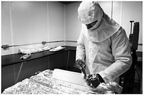 Scientist cleaning a piece of ice core in the cold clean room. SOURCE: Geoffrey Hargreaves, NICL. 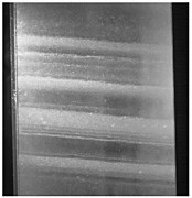 Close-up of an ice core from the Greenland Ice Sheet Project. After an ice core is cleaned, it is sawed in half lengthwise to reveal features like these seen here. The bands are formed by individual years of snow accumulation; the core in this photograph contains a sampling of 4 or 5 years of ancient atmospheric conditions. The core was collected from a depth of 1,850 meters (6,070 feet). The age of ice at that depth is approximately 16,750 years. The width of the ice in the picture is 5.2 inches. SOURCE: Geoffrey Hargreaves, NICL. |


