
4
Capabilities of Current and Planned Ocean Color Sensor Missions
The previous chapter discussed the essential requirements for a successful ocean color mission (including requirements for sensor design, stability monitoring, vicarious calibration, and a calibration/validation program). This chapter examines the capabilities of planned sensors and missions to meet these requirements. We provide only a brief description of current and planned ocean color satellite sensors (for details see Appendix A). The chapter compares the sensors’ capabilities to the minimum requirements outlined by the committee, with commentary on design approaches that enhance data accuracy and stability. In addition, it assesses the likelihood that these sensors will deliver products of sufficient quality. As discussed in Chapter 2, a single sensor or mission cannot meet the needs of all ocean color products. Because the charge to the committee is limited to Type 1 and 2 sensors, this analysis focuses on their capabilities.
CURRENT AND PLANNED OCEAN COLOR SENSORS
Figure 4.1 illustrates the timeline for past and planned launches of U.S. and foreign ocean color sensors. Launches of the Sea-viewing Wide Field-of-view Sensor (SeaWiFS) and Moderate Resolution Imaging Spectroradiometer (MODIS) sensors were closely spaced, which resulted in a continuous U.S. data stream for remotely sensed ocean color. This close spacing resulted in sensor overlap, which made it possible to intercalibrate these sensors (for details see Chapter 3). However, SeaWiFS just recently ceased operations and the only other U.S. sensor in orbit, MODIS, is beyond its planned life span. The next U.S. sensor, Visible Infrared Imager Radiometer Suite (VIIRS) on National Polar-orbiting Operational Environmental Satellite System (NPOESS) Preparatory Project (NPP), is not planned for launch until fall 2011 or later. Therefore, U.S. scientists are at risk of losing access to an ocean color data stream. The Medium-Resolution Imaging Spectrometer (MERIS) is currently operating, although it is also beyond its design lifetime. While a foreign Type 2 sensor has recently been launched (Ocean Colour Monitor on-board Oceansat-2 [OCM-2]), questions of data access and data quality assurance need to be resolved, as discussed below.
Details of the character of each currently operating sensor are listed in Table 4.1. Characteristics of planned launches are listed in Table 4.2 (additional details in Appendix A).
As discussed in Chapter 2, the diverse set of data specifications required to meet all ocean color user needs requires different types of satellite sensors. Figure 4.1 shows that many sensors will be available, but Tables 4.1, 4.2, and 4.3 illustrate that they vary widely, each with its own capabilities and limitations. Although nine ocean color satellite missions have been launched to date, only four (CZCS, SeaWiFS, MERIS, and MODIS-Aqua) have acquired high-quality global observations. This record raises concerns for the probability of success of the upcoming missions shown in Figure 4.1.
For example, data from the MODIS-VIIRS line of sensors can provide routine coverage of the global ocean at 1-km resolution. But U.S. users need access to other polar-orbiting satellite ocean color data streams for (1) coastal and other applications, (2) to improve coverage of the global ocean using merged datasets from multiple sensors, and (3) as a backup for global coverage in the event of a failure of a U.S. sensor. The sensors with known or likely capabilities to serve these needs are MERIS on the European Space Agency’s (ESA) Environmental Satellite (ENVISAT), Ocean Land Colour Instrument (OLCI) to be flown on ESA’s Sentinel 3A and 3B satellites, Second-Generation Global Imager (S-GLI) to be flown by Japan Aerospace Exploration Agency (JAXA), and OCM-2, currently operating in space and maintained by the Indian Space Research Organization (ISRO). Data from other polar orbiting sensors may also be available, but their characteristics and mission operating procedures are less well known to the U.S. community.
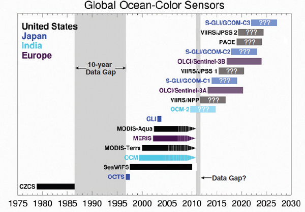
FIGURE 4.1 The launch sequence of past, current, and planned ocean color sensors in polar orbit are displayed. The sensors still operational are shown with a one-sided arrow; the hatched area indicates when a sensor is beyond its design life. The gray shaded background indicates a data gap in the past and a potential data gap arising if MODIS sensors and MERIS cease today. The question marks are used to indicate sensors that either do not yet meet the minimum requirements or are vulnerable to changes in funding allocation. Future sensors are shown having either a five- or seven-year lifetime, according to their individual specifications. CZCS: Coastal Zone Color Scanner; OCTS: Ocean Color and Temperature Scanner; SeaWiFS: Sea-viewing Wide Field-of-view Sensor; OCM/OCM-2: Ocean Colour Monitor; MODIS-Terra/MODIS-Aqua: Moderate Resolution Imaging Spectroradiometer on Terra/Aqua, respectively; MERIS: Medium Resolution Imaging Spectrometer; GLI: Global Imager; VIIRS: Visible Infrared Imager Radiometer Suite; OLCI: Ocean Land Colour Instrument onboard Sentinel-3; PACE: Pre-Aerosol-Clouds-Ecosystem; GCOM-C: Global Change Observation Mission for Climate Research; JPSS: Joint Polar Satellite System.
SOURCE: Based on data from http://www.ioccg.org/sensors_ioccg.html.
TABLE 4.1 Current Sensors in Space Having Spectral Bands and Other Specifications That Provide Typea 1 or 2 Ocean Color Sensor Capabilities
| Sensor/Satellite/Type | Agency | Launch Date | Swath (km) | Spatial Resolutionb (m) | Bands (visible/total) | Spectral Coverage (nm) | |
| MODIS/Terra/1 | NASA (USA) | 1999 | 2,330 | 250/500/1,000 | 9/36 | 405-14,385 | |
| OCM-1/IRS-P4/2 | ISRO (India) | 1999 | 1,420 | 360/4,000 | 7/8 | 412-885 | |
| MERIS/2 | ESA (Europe) | 2002 | 1,150 | 300/1,200 | 12/15 | 412-1,050 | |
| MODIS/Aqua/1 | NASA (USA) | 2002 | 2,330 | 250/500/1,000 | 9/36 | 405-14,385 | |
| OCM-2/Oceansat2/2 | ISRO (India) | 2009 | 1,420 | 360/4,000 | 7/9 | 400-900 | |
Listed in ascending order of launch date (for details see Appendix A).
a Sensors are characterized into Type 1-4 based on their spatial and spectral coverage and orbit (see Table 2.1).
b The sensor has some capability to sample at higher spatial resolution.
Conclusion: U.S. research and operational users of satellite ocean color data will have to rely on multiple sources, including sensors operated by non-U.S. space agencies, because the United States does not have approved missions that will sustain optimal ocean color data for all applications.
ANALYSIS OF CAPABILITIES AND GAPS
Our analysis of current and future capabilities is focused on the Type 1 and 2 sensors listed in Table 4.2 (those capable of providing global coverage approximately every two to three days), because most of the past experience is limited to
TABLE 4.2 Planned Sensors Having Spectral Bands and Other Specifications That Provide Type 1 and 2 Ocean Color Capabilities
| Sensor/Satellite/Type | Agency | Launch Date | Swath (km) | Spatial Resolution (m) | Bands | Spectral Coverage (nm) | |
| VIIRS/NPP/1 | NOAA/NASA (USA) | 2011 | 3,000 | 370/740 | 22 | 412-11,800 | |
| OLCI/Sentinel-3A/2 | ESA/EUMETSAT (Europe) | 2013 | 1,270 | 300/1,200 | 21 | 400-1,020 | |
| S-GLI/GCOM-C | JAXA (Japan) | 2014 | 1,150-1,400 | 250/1,000 | 19 | 375-12,500 | |
| VIIRS/JPSS/1 | NOAA/NASA (USA) | 2016 | 3,000 | 370/740 | 412-11,800 | ||
| OLCI/Sentinel-3B/2 | ESA/EUMETSAT (Europe) | 2017 | 1,265 | 260 | 21 | 390-1,040 | |
| PACE/2 | NASA (USA) | 2019 | |||||
| VIIRS/JPSS1/1 | NOAA (USA) | 2019 | 3,000 | 370/740 | 22 | 412-11,800 | |
| ACE/2 | NASA (USA) | 202X | 1,000 | Hyperspectral at 5 nm; 3 discrete SWIR bands | 350-2,130 | ||
Listed in ascending order of scheduled launch date.
TABLE 4.3 Planned Type 3 Sensor(s)
| Sensor/Satellite | Agency | Launch Date | Swath | Resolution | Bands | Spectral Coverage (nm) | |
| HyspIRI | NASA (USA) | Unknown | 600 km | 60 m | Hyperspectral at 10 nm | 380-2,500 | |
sensors of that type and because our goal is to assess options to ensure continuity in global ocean color data. The other sensors are critical to advance research applications, but as new sensors they are not essential to the continuity of the long-term global ocean color time-series.
Based on freely available information, the committee assessed whether current and planned sensors would meet some of the elements essential to the success of an ocean color mission, as listed in Chapter 3 (Table 4.4): pre-launch instrument characterization and calibration, post-launch stability monitoring, sun-glint avoidance, vicarious calibration, data processing and reprocessing, freely available user-friendly processing software, and availability of raw data and information on instrument characterization. These last two data-related requirements are of particular importance to climate and other scientific applications.
Table 4.5 lists the spectral bands for the sensors identified in Table 4.4, showing wide agreement among agencies and nations regarding the most important spectral capabilities for ocean color that are required to sustain current capabilities. A notable exception is the VIIRS sensor on NPP and Joint Polar Satellite System (JPSS), which is missing the 510- or 530-nm bands. Given the advances in ocean color algorithms for turbid waters (Morel and Bélanger, 2006), the result of these missing wavebands will lead to sub-optimal retrievals of chlorophyll and possibly other derived products in turbid coastal waters. Moreover, the large spectral gap between 555 and 665 nm has been problematic for remote sensing of coastal and shallow water habitats. For example, a band at 640 nm is critical for semi-analytical inversion models in coastal waters (Lee algorithm in IOCCG Report 5, 2006). Also, many sensors are missing the fluorescence bands.
The signal-to-noise ratio (SNR) of all wavebands on MERIS and VIIRS (both on NPP and JPSS) are equivalent to or better than the SNR for the wavebands on the SeaWiFS sensor (NOAA, 2010). In particular, reduction of the digitization of the NIR channels in SeaWiFS was an important source of noise in open ocean retrievals (Hu et al., 2004). The SNRs for 412-, 443-, 490-, and the 510-nm bands on OCM-2 and in the 761-nm band on OLCI and Second-Generation Global Imager (S-GLI) are worse than for respective bands on SeaWiFS (NOAA, 2010). All sensors listed in Tables 4.2 and 4.3 have been or are being designed to offer measures of the satellite radiances in various visible, NIR and/or shortwave infrared (SWIR) spectral bands, as well as for land applications. These latter bands are and will continue to be important for atmospheric corrections.
ENSURING GLOBAL HIGH-QUALITY OCEAN COLOR DATA FOR THE NEXT TWO TO FIVE YEARS
The greatest risk identified by the committee is that U.S. scientists and resource managers will lack access to high-quality ocean color data between now and the launch of Pre-Aerosol-Clouds-Ecosystem (PACE) (planned for 2019).
TABLE 4.4 Comparing SeaWiFS with Current and Planned Sensors Against Some Important Sensor and Mission Requirements
| SeaWiFS | MODIS-Aqua | MODIS-Terra | VIIRS NPP | VIIRS JPSS-I | PACE | ACE | MERIS | OLCI | OCM | OCM-2 | S-GLI | |
| Pre-launch Instrument Characterization | Yes | Yes | Yes | Yes | TBD | Mission requirement | Mission requirement | Yes | Yes | TBD | TBD | TBD |
| Stability Monitoring (lunar calibration or solar diffuser) | Yes; monthly lunar look | Yes; single solar diffuser with stability monitor; monthly views of the moon | Yes; single solar diffuser with stability monitor; monthly views of the moon | No; single solar diffuser with stability monitor, occasional views of the moon | TBD; single solar diffuser with stability monitor, occasional views of the moon | Mission requirement | Mission requirement | Yes; dual solar diffuser | Yes; dual solar diffuser | No | Planned two times per year | Yes; solar diffuser and monthly lunar look |
| Sun-Glint Avoidance | Yes; tilts | Mid-AM/mid-PM orbits compensate | Mid-AM/mid-PM orbits compensate | No | No | Mission requirement | Mission requirement | No | Yes, permanent across track tilt | Yes; tilts | Yes; but optimized for the Indian Ocean | Yes |
| Vicarious Calibration | MOBY | MOBY and SeaWiFS | MOBY and SeaWiFS | TBD; assumed use of MOBY | TBD; assumed use of MOBY | Mission requirement | Mission requirement | Planned for 2011 to use MOBY, Boussole | Planned to use MOBY, Boussole | No | Asked for MOBY | Assumed use of MOBY |
| Data Reprocessing | Yes | Yes | Yes | No | TBD | Mission requirement | Mission requirement | Yes | Yes | Unknown | TBD | Planned |
| Participates in a Continuity Plan for Heritage Missions | Yes | Yes (via SeaWiFS) | Yes (via SeaWiFS) | No | TBD | Mission requirement | Mission requirement | Yes | Yes | No | Member of OCR-VC | Yes |
| Data Exchange agreement for L-0 and L-1 data | Yes | Yes | Yes | No | TBD | Likely | Likely | TBD | TBD | TBD | TBD | Yes |
Sensors from U.S. agencies are listed in white fields, from the European Space Agency in purple, from India in teal-colored fields, and from the Japanese space agency in blue.
SOURCE: Adapted from National Oceanic and Atmospheric Administration’s Report, Ocean Color Satellite Continuity Mitigation Plan Revision 2, Final Report.
TABLE 4.5 SeaWiFS Spectral Bands and Those of Current and Planned Sensors
| Ocean Color Data Sources | |||||||||
| SeaWiFS | MODIS-Aqua | MODIS-Terra | MERIS Envisat | OCM-2 Oceansat | OLCl Sentinel 3A & 3B | S-GLI GCOM | VIIRS NPP | VIIRS NPOESS/JPSS | |
| Band Center | Band | Band | Band | Band | Band | Band | Band | Band* | Band* |
| 412 | 412 | 412 | 412 | 412.5 | 412 | 413 | 412 | 412 | 412 |
| 443 | 443 | 443 | 443 | 442.5 | 443 | 443 | 443 | 445 | 445 |
| 490 | 490 | 488 | 488 | 490 | 490 | 490 | 490 | 488 | 488 |
| 510 | 510 | 531 | 531 | 510 | 510 | 510 | 530 | ||
| 555 | 555 | 551 | 551 | 560 | 555 | 560 | 565 | 555 | 555 |
| 670 | 670 | 667 | 667 | 665 | 620 | 665 | 674 | 672 | 672 |
| 678 | 678 | 678 | 681 | ||||||
| 765 | 765 | 748 | 748 | 778.8 | 740 | 778 | 763 | 746 | 746 |
| 865 | 865 | 869 | 869 | 865 | 865 | 865 | 869 | 865 | 865 |
Note band differences among the sensors.
SOURCE: Adapted from National Oceanic and Atmospheric Administration’s Report, Ocean Color Satellite Continuity Mitigation Plan Revision 2, Final Report.
This high risk results from a combination of factors: the loss of SeaWiFS, the quality and age of the MODIS sensors, concerns with aspects of the VIIRS/NPP mission, and lack of adequate data access to foreign sensors. Concerns with the VIIRS/NPP mission result from uncertainty regarding the quality of and access to data. To minimize the risk of a data gap, this section will assess the three sensors most likely in orbit and capable of delivering ocean color data in the near term, with regard to their ability to meet key requirements.
MERIS Assessment
As discussed in the previous chapter and indicated in Table 4.5, the MERIS sensor was well characterized and calibrated pre-launch (Rast et al., 1999). In fact, the committee concludes that this careful characterization contributed significantly to the mission’s success.
Although the MERIS mission is not designed to use lunar looks for stability monitoring, its approach of using dual solar diffusers appears to be adequate to monitor the sensor’s stability. MERIS uses one solar diffuser every two weeks; the second is used every three months to check the stability of the first. The second diffuser is assumed to offer constant reflectance, which provides a check on the reflectance change of the first. The last calibration analysis shows a 1.5 percent degradation of the diffuser between 2002 and 2010 in the blue (443 nm) band and no detectable degradation in other bands.
Because of the careful pre-launch characterization and calibration, a vicarious calibration was initially assumed to be unnecessary. However, the benefit of the vicarious calibration has been subsequently recognized (Antoine et al., 2008). Marine Optical Buoy (MOBY) and BOUSSOLE (Bouée pour l’acquisition de Séries Optiques à Long Terme; Antoine et al., 2006, 2008) were used for this purpose and the calibration has been completed. BOUSSOLE is a joint European ocean color calibration and validation activity to which NASA also contributes.
The MERIS sensor is not tilted to avoid sun glint. Pixels with “moderate sun glint” are identified and a correction is applied to increase the coverage area (Bézy et al., 2000). Pixels with higher levels of sun glint are simply flagged and users are left to judge whether they can use the data or not.
Level 0 data generally are not available to users. This is only of concern to those users who may want to process and reprocess the data with the original raw data (see previous discussion in this report). Level 1 data are available in near-real time (about three hours after acquisition) and again after processing for accuracy, within about three weeks (Bézy et al., 2000). Level 2 data also are freely available and mapped. MERIS data have been used in particular in producing the multi-sensor global GlobColour merged data products (Maritorena et al., 2010). A major reprocessing of the entire mission has been achieved, which includes a Level 2 vicarious calibration similar to the one applied to the NASA SeaWiFS and MODIS instruments (e.g., Gordon, 1998; Franz et al., 2007) that improves compatibility across these missions.
The ocean color group at the National Aeronautics and Space Administration’s (NASA’s) Goddard Space Flight Center (GSFC) typically prefers to work with Level 0 data but can use as an alternative Level 1B imagery. Such imagery is available so long as ESA provides updates and the GSFC group has access/insight to the sensor issues, as is currently the case through GSFC participation in the MERIS “Data Quality Working Group” (DQWG). Although Level 3 data have become available recently, some U.S. users were dis-
couraged that they did not have access to Level 3 data from the mission’s start.
Conclusion: The MERIS mission and sensor design meet most requirements and show great promise for data to reach climate quality. Incorporating NASA scientists into ESA’s MERIS Data Quality Working Group is a very positive development that ideally would continue.
OCM-2 Assessment
All sensors currently in polar orbit are beyond their design lives, with the exception of OCM-2. If these sensors fail, OCM-2 will be the only ocean color sensor in space until the launch of VIIRS on NPP. Therefore, this sensor might become an important component of a mitigation plan to minimize a data gap.
The committee was not able to review the status of the pre-launch characterization and calibration due to lack of information. Importantly, OCM-2 assesses sensor stability using solar and lunar calibrations. ISRO has established a cal/val optical buoy in the Lakshadweep Sea to perform a vicarious calibration.
OCM-2 tilts the sensor twice per year to avoid the sun glint over the Indian Ocean. Thus, the current sun-glint avoidance mechanism is optimized for the Indian Ocean. Because of this constraint, the mission is not designed to acquire global data.
Although India is a member of the virtual ocean color constellation group and has plans to make products available online, no data agreements have yet been established to access data from OCM-2 for U.S. investigators. However, the U.S. and Indian space agencies have held productive discussions to negotiate data exchange agreements.
Because OCM-2 is the only ocean color sensor in orbit that has not exceeded its design life, negotiating data access from the Indian Space Agency is the only option to avoid losing near-term access to ocean color data, if the older sensors fail. Even if U.S. users acquire access to the data, at present it is difficult to assess whether this sensor could produce climate-quality ocean color products. For example, the tilt of OCM-2 is currently optimized only for the Indian Ocean; however, OCM-2 views the moon and the sun to assess sensor stability. Before it can be determined whether OCM-2 products will be of equivalent high-quality to SeaWiFS products, access to data, including characterization and calibration data, needs to be worked out. In addition, it is unclear at this point if the mission’s operations can include global coverage. For OCM-2 to meet the requirements of a vicarious calibration, routine reprocessing and stability monitoring need to be implemented. Therefore, it is not yet possible to determine whether OCM-2 can provide climate-quality global data. Finally, there is no plan to routinely access OCM-2 data, although NOAA has successfully negotiated access to vector wind data from Oceansat-2.
Conclusion: Many issues are unresolved with regard to the high quality of and access to OCM-2 data.
Conclusion: Because of the age of MERIS and MODIS, data availability from these sensors may be lost soon. Therefore, OCM-2 and VIIRS on NPP may be the only Type 1 and 2 ocean color missions in orbit until the launch of JAXA’s S-GLI and ESA’s OLCI sensors. Therefore, data access to OCM-2 may be the only option to mitigate a data gap, if VIIRS/NPP fails to meet the requirements and both MERIS and MODIS stop operating.
Recommendation: NASA and NOAA’s current efforts to resolve international data access issues should continue and be given high priority. NASA, NOAA, and ESA should continue to include foreign scientists as part of their mission science teams to foster information and data exchange.
VIIRS/NPP Assessment
In 2007, the ocean color community articulated problems with the NPOESS’ NPP VIIRS (Siegel and Yoder, 2007). Users were concerned about the ability of the VIIRS on NPP to deliver multi-spectral data of sufficient quality to sustain the time-series of oceanographic products derived from SeaWiFS and MODIS-Aqua. The community reached these conclusions based on an NPOESS Integrated Program Office (IPO) report regarding VIIRS on NPP laboratory performance tests. Optical cross-talk was of greatest concern.1
The community suggested two options to mitigate risk of a disruption of the ocean color data record:
1) Aggressively pursue and document improvements to the VIIRS sensor on NPP that enable it to meet the specifications required for climate capable ocean color observatories; or
2) Implement a stand-alone, global ocean color mission.
(Siegel and Yoder, 2007)
The second option was not pursued. This study aims to assess whether improvements to the VIIRS sensor and mission that have been and continue to be made will allow VIIRS data to meet the requirements for climate-quality ocean color data.
As this report was being written, VIIRS/NPP was successfully integrated to the spacecraft; it now awaits launch. After integration with the spacecraft, NIST conducted full system tests of VIIRS radiometric performance. These tests included evaluation of relative spectral response (RSR), polarization sensitivity, and stray light characterization. These tests quantified VIIRS’ non-compliance of integrated out-of-band (OOB) response and cross-talk among relevant ocean color spectral bands. Dynamic and static electrical
____________________________
1 Optical cross-talk is scattering of light from one band to another, caused by defects in the manufacturing of the VIIRS Integrated Filter Assembly (IFA).
and optical cross-talk was observed. Quantitative analysis of optical cross-talk is in progress. In parallel, Northrop Grumman Aerospace Systems (NGAS) proposed a data-processing correction method that is in government peer review. It is our expectation that the optical cross-talk that is a result of defects in the VIIRS Integrated Filter Assembly (IFA) will be corrected for the second VIIRS sensor. The hardware issue will remain in the VIIRS/NPP. The VIIRS/NPP optical cross-talk and OOB shortfalls compared with the VIIRS specification affect the performance of ocean color and aerosol observations.
Otherwise, the pre-launch VIIRS/NPP tests conducted by NIST indicate that the sensor meets SNR, dynamic range, linearity, uncertainty, stability, and polarization specifications (Turpie, 2010). Tests detected minor variances for gain transition, but gain transition points are well characterized. Tests also identified potential “striping.” Striping, evident in MODIS Level 1a and 2 imagery, is typically seen in dark ocean scenes where small errors in detector gain and offset correction cause brightness variations from one detector to the next over a cross-track scan. Plans for post-launch striping correction similar to those applied to Landsat and MODIS data are in place if needed. Overall, VIIRS/NPP meets requirements for noise-equivalent radiance, dynamic range, gain transition, linearity, uniformity, absolute radiometric difference, and stability. Therefore, the VIIRS environmental data records (EDRs) are expected to meet Integrated Operational Requirements Document thresholds, with the possible exception of ocean color and aerosol optical depth.
Conclusion: Because of the VIIRS/NPP issues described above, the committee expects that deriving high-quality ocean color products from VIIRS/NPP is possible but will be challenging. The importance of vicarious calibration, stability monitoring, and a vigorous calibration/validation effort cannot be overstated and are discussed in more detail in Chapter 3.
In November 2010, the NPP project scientist told the committee:
We are optimistic that the [NPP] VIIRS instrument may still be a viable ocean color instrument, provided that the calibration and validation infrastructure of heritage NASA EOS missions is in place. This infrastructure includes a plan and support for vicarious calibration site(s), a data/validation program, on-orbit calibration maneuvers, regular mission-level data reprocessing, and the use of NASA selected operational algorithms. The VIIRS on-orbit performance, due to the OOB calibration biases alone, should be no worse than SeaWiFS. If the VIIRS OOB calibration biases are not adversely complicated by the cross-talk, the heritage OOB mitigation approaches that were developed for SeaWiFS and MODIS-Aqua should work for VIIRS. These approaches use vicarious calibration as the primary correction for the OOB bias in the calibrated [top of atmosphere] TOA radiances, then use direct OOB corrections of the water-leaving radiances to remove residual OOB biases.
(Presentation to NRC by J. Gleason, November 2010)
Although the committee is pleased that JPSS plans a vicarious calibration program to address ocean color issues on NPP VIIRS, it is critical that plans for vicarious calibration, as well as plans for routine reprocessing and stability monitoring, are in fact implemented.
As concluded in the previous chapter, a vicarious calibration is critical to overcoming some of the sensor’s shortcomings and to ensure accuracy requirements for Lw are met. Currently, MOBY (or a MOBY-like approach) is the only proven and operational approach to undertake such a vicarious calibration. However, at the time that this report was completed, funding allocations for a MOBY-like vicarious calibration program were insufficient. The committee was not aware of any definitive plans to conduct a MOBY-like effort for VIIRS/NPP in the near term.
The committee heard arguments that, due to time pressure in delivering ocean color to the operational community quickly and the limited number of match-ups during the first year, the project office may rely more heavily on SeaWiFS2 and MODIS data during the first year to set the gain factor.
It is true that during the first year obtaining enough match-ups to set the gain may be difficult (vicarious calibration for SeaWiFS over 13 years yielded 160 match-ups). Nonetheless, it remains imperative that MOBY be maintained until an alternative proven approach has been tested and deployed. A MOBY or a MOBY-like approach needs to be maintained continuously to develop the required dataset of match-ups. Indeed, because it takes many years and many vicarious calibration points to get down to 0.3 percent absolute accuracy, the vicarious calibration effort will yield high-quality products sooner if it begins immediately after launch.
Conclusion: Without a MOBY-like approach to vicarious calibration, the accuracy requirements of the climate research community cannot be met.
There is an overwhelming probability that a disruption in funding will result in the disbanding of the group with the technical and institutional memory to operate a system such as MOBY. To date, an appropriate alternative approach to conduct a vicarious calibration has not been demonstrated. Because NOAA is responsible for the calibration of VIIRS and for maintaining climate data records, NOAA is also responsible for maintaining the capability to conduct a vicarious calibration. Funding to maintain the proven vicarious calibration approach seems to be easily justified, considering the importance of the vicarious calibration to the overall success of the VIIRS/NPP mission, and the small cost of the program compared to the overall mission cost.
____________________________
2 These comments were made prior to the failure of SeaWiFS.
Conclusion: Based on experience with SeaWiFS and MODIS, a MOBY-like approach for a vicarious calibration is the proven method to meet the accuracy requirements for climate-quality data. Because of a funding shortage, VIIRS/NPP may use MODIS for the vicarious calibration during the first year, primarily for operational applications. However, this approach does not meet the accuracy requirements listed in the previous chapter.
Conclusion: Based on NIST’s most recent and thorough instrument characterization, the VIIRS sensor on NPP continues to have problems with the filter cross-talk and out-of-band response. The approach with the best chance for obtaining ocean color CDRs from VIIRS/NPP is to implement a vicarious calibration program based on MOBY match-ups and to monitor sensor stability with a monthly lunar look.
Conclusion: If it is NOAA’s goal to produce climate-quality ocean color data from VIIRS/NPP, NOAA funding for the vicarious calibration needs to be sufficient to support the current level of MOBY operations and the development and deployment of a replacement unit.
VIIRS is patterned after MODIS, with an improved solar diffuser design based on lessons learned from MODIS-Terra. In addition to providing deep space and lunar views available roughly quarterly without spacecraft maneuvers, VIIRS also contains the MODIS-derived solar diffuser stability monitor. However, the experience with MERIS demonstrates that the stability of the solar diffuser needs to be monitored, and this ability depends on how well the stability monitor on VIIRS will perform. The SeaWiFS and MODIS experiences indicate that monthly lunar looks will be required despite the solar diffuser and stability monitor, because instrument degradation is not always predictable. Furthermore, vicarious calibration cannot be used to determine the rate of degradation of the atmospheric correction bands, because the water-leaving radiance signal is so low at those wavelengths. Thus, the only option for VIIRS to monitor degradation in those bands is with a lunar look. A presentation to the committee by Fred Patt stated VIIRS will image the moon three to four times a year with no maneuvering of the spacecraft. This does not meet the requirement of monthly sampling frequency. Patt also stated that small roll maneuvers (fewer than 15 degrees) are required to acquire eight to nine additional lunar calibration views per year (Patt VIIRS ATBD document). If implemented these roll maneuvers would increase the number of lunar views to the required monthly frequency. At the time this report was prepared, no final decision had been made whether to implement roll maneuvers. However, the original instructions were to not implement roll maneuvers.
Conclusion: VIIRS/NPP is currently scheduled to collect four lunar looks per year, which is insufficient to meet the requirement. To monitor the sensor degradation, a 15-degree roll maneuver of the spacecraft eight to nine times a year would be sufficient to meet the requirement of obtaining monthly lunar looks.
Recommendation: JPSS should conduct spacecraft maneuvers to collect monthly lunar looks for VIIRS/NPP.
The Sensor Intercomparison and Merger for Biological and Interdisciplinary Oceanic Studies (SIMBIOS) program has contributed to the success of the SeaWiFS and MODIS missions. The SIMBIOS program led the effort to validate the ocean color products. Besides calibrating the sensor with solar and lunar views and MOBY match-ups, it collected and archived a global dataset of in situ data to ground-truth the satellite products. In addition, the program was very successful in developing working relationships with the international community and foreign space agencies (McClain, 2010).
Although plans presented to the committee for calibration and validation included all necessary elements, the funding to support these efforts for VIIRS/NPP was not available. In addition, the plans were relatively limited in scope and lacked details to ensure a successful implementation. They appeared limited to U.S. coastal waters. Considering the fast-approaching launch date of the VIIRS sensor, the committee concludes that a high level of uncertainty remains regarding the availability of a high-quality calibration and validation program such as the SIMBIOS program.
The committee is most concerned about the current uncertainty regarding the timing and level of NOAA’s financial support for a MOBY-type vicarious calibration program (DiGiacomo and Guenther, personal communication), as well as NOAA’s apparent lack of commitment and capability to reprocess the VIIRS data (NOAA, 2010). Both are absolutely essential if VIIRS is to produce climate- and science-quality data. These concerns were echoed by all workshop and meeting participants throughout the study period and had not been resolved at the time this report was concluded (sixth months prior to launch date).
NOAA plans to process, archive, and distribute VIIRS data. However, based on its report to the committee (NOAA, 2010), NOAA does not have (nor has it demonstrated) the technical and infrastructure capabilities to do end-to-end processing and reprocessing of ocean color data.
Moreover, reprocessing of the data is not included in the data management plans contemplated for VIIRS/NPP. Reprocessing of data is required for the development of climate-quality data records. In addition, NOAA has not yet developed the mechanisms to engage experts in the academic and international community to provide feedback and revise algorithms and methods for product development. NOAA has recognized this deficiency and is attempting to develop the in-house capacity for end-to-end data processing (NOAA, 2010). However, the current management structure of JPSS (separate from NOAA/National Environmental
Satellite, Data, and Information Service [NESDIS] presents an additional challenge to NOAA to implement the agency’s own recommendations (NOAA, 2010).
The NASA Ocean Color Group has the expertise and resources to do end-to-end processing of VIIRS data. NASA is capable of developing a processing system by launch, and VIIRS ocean color products would be processed and available through mechanisms that are familiar to the research and operational community. Further, as of today, no module exists to provide access to Level 3 data from VIIRS/NPP. The NASA Ocean Color Group has built such modules for SeaWiFS, MODIS, and MERIS. It has a code in place to bin VIIRS data to Level 3 and the expertise to make the module available for VIIRS/NPP data. To build its own in-house capacity for end-to-end processing, NOAA is well advised to engage NASA to enable the knowledge transfer (NOAA, 2010).
Conclusion: NOAA is responsible for data management of VIIRS ocean color products for the nation but has not yet demonstrated that it has the required expertise or infrastructure to successfully achieve this task. The NASA Ocean Color Group does not have the funding to process, reprocess, and distribute VIIRS data, but has the unique expertise and infrastructure. Contracting the NASA Ocean Color Group to manage VIIRS/NPP data is the only option for the foreseeable future to ensure high-quality management of VIIRS data. NOAA and NASA should work together to shift this capability to NOAA as soon as possible, or they should develop a partnership for ocean color processing that serves the missions of both agencies.
Conclusion: As of now, the following requirements are not met for VIIRS/NPP:
• Stability monitoring;
• Data processing, reprocessing and distribution;
• Vicarious Calibration program;
• Global validation program throughout the life span of the mission; and
• Algorithm development and research.
Conclusion: The VIIRS sensor on NPP continues to have problems with the filter cross-talk and out-of-band response. It remains to be seen whether optical cross-talk issues can be overcome on orbit via software corrections. VIIRS on NPP has the potential to meet requirements only if a vicarious calibration is undertaken and the sensor stability is monitored with a monthly lunar viewing.
Recommendation: If VIIRS/NPP is to continue to provide SeaWiFS/MODIS-quality ocean color data, NOAA should immediately implement the following:
• spacecraft maneuvers throughout the life of the mission to provide monthly lunar looks to quantify sensor stability;
• fund MOBY and a new MOBY-like program to replace the aging MOBY; and
• a capability equivalent to the NASA Ocean Color Group to process, reprocess, and distribute VIIRS data in a manner consistent with the heritage missions (CZCS, SeaWiFS, and MODIS).
Conclusion: NOAA’s ocean color mission would benefit from engaging the NASA Ocean Color Group at Goddard Space Flight Center to process, archive, distribute, and reprocess NPP/VIIRS data in the near term. Initially, this could be accomplished through subcontracting its services, although this is not a long-term solution.
An option to ensure the availability of a capacity equivalent to NASA’s Ocean Color Group is to contract with that group. Such a contract should include but not be restricted to these tasks:
• process, reprocess, distribute the data, and generate new and improved products;
• work with the VIIRS calibration team to assess trends in sensor performance and to evaluate anomalies;
• implement a process to engage experts in the field of ocean color research to revisit standard algorithms and products, including those for atmospheric correction, to ensure consistency with heritage instruments and for implementing improvements; and
• form a data product team to work closely with the calibration and validation teams to implement vicarious and lunar calibrations, expand global validation efforts and provide oversight of reprocessing.
Recommendation: NOAA should extend the validation program to cover the full range of global ocean conditions.
ENSURING GLOBAL HIGH-QUALITY OCEAN COLOR DATA FOR THE NEXT FIVE TO TEN YEARS
While the most immediate need and highest priority is to ensure that the VIIRS/NPP mission is of highest quality possible, some near-term missions also hold great promise. The most promising are two foreign missions. The third mission we consider here is the second VIIRS sensor, to be launched as part of the JPSS1 mission.
Sentinel Mission
ESA is developing an operational mission as part of its Global Monitoring for Environment and Security (GMES) program. Because the Sentinel mission is operational, the requirements for revisit, coverage, and mission life cycle are stringent. Two OLCIs are being built as part of this program; the first OLCI (3A) is to be launched in April 2013. The design follows MERIS with a dual Spectralon solar diffuser stability monitoring system and deep space looks. The committee hopes this will include a vicarious calibration of sensor gains, as is being done now for MERIS. The OLCI comprises five independent narrow field-of-view cameras arranged in a fan configuration to offer a total 68.5-degree field-of-view, tilted 12.5 degrees off-nadir to avoid sun glint. It will have 21 spectral channels compared to the 15 on MERIS. Based on the quality of the MERIS mission and the design features of these sensors, data likely will be of high quality, especially because climate research is one of its main applications. This assumes that a vicarious calibration will be pursued as has been recently done for MERIS. However as with MERIS, questions regarding data access will need to be resolved before Sentinel will fully satisfy the requirements of U.S. resource managers and scientists.
Conclusion: The Sentinel sensor and mission description are promising, but data access needs to be resolved.
S-GLI/GCOM-C1 and GCOM-C2
The Japanese Global Change Observation Mission (GCOM) also plans to launch two ocean color sensors for climate monitoring purposes. As discussed, this goal is associated with stringent mission and sensor requirements. To monitor the sensor’s stability, the SGLI Visible and Near-Infrared Radiometer (VNR) offers a Spectralon solar diffuser, internal light-emitting diodes (LED) sources, and deep space views. With planned satellite maneuvers, lunar looks also are anticipated. The sensor will have 19 wavebands (375 to 12,500 nm) and a spatial resolution of 250 m, with the goal to improve coastal and aerosol observations. Following an initial evaluation period, the data products are likely to be openly available, as was the case for OCTS and GLI, although it is not yet clear if near-real time access will be an option for U.S. coastal waters.
Conclusion: Based on the sensor and mission description and operation for S-GLI, and given past history with data access to OCTS, S-GLI could meet all requirements and be an excellent Type 1 and 2 sensor.
VIIRS/JPSS1 and JPSS2
Because VIIRS/NPP was designed as the preparatory mission for the operational program, lessons from VIIRS/NPP should be applied to VIIRS/JPSS1 to ensure improvements are made. The VIIRS sensor on the JPSS1 mission needs to include an improved filter array to avoid the cross-talk problems associated with VIIRS on NPP. As discussed in the previous section, many issues remain regarding the overall mission planning and design, including stability monitoring, vicarious calibration based on a MOBY-like standard, pre-launch characterization, and data validation/calibration and processing/reprocessing.
Based on what we have learned to date, all recommendations for VIIRS on NPP need to be implemented for VIIRS/JPSS1, in particular:
• Stability monitoring;
• Vicarious calibration based on a MOBY-like approach;
• Pre-launch characterization of VIIRS/NPP applied to all follow-on missions; and
• Processing, reprocessing, and distribution (for details see Chapter 5).
If the problems with the first VIIRS can be avoided during the JPSS phase, these follow-on missions can deliver climate-quality ocean color data.
PACE and ACE
ACE is one of NASA’s Decadal Survey missions and would include an advanced ocean color capability to serve the research community. PACE was announced in 2010 as part of NASA’s Climate Initiative and is an advanced ocean color imager with requirements similar to those planned for ACE. Very little information about PACE or ACE was available to the committee. Based on a draft document provided by C.R. McClain (NASA’s GSFC), the ocean color radiometry requirements for ACE (and presumably for PACE) are given below. The requirements are stringent; if they are met, PACE and ACE would satisfy many of the ocean color needs of the research community discussed in Chapter 5.
The ocean radiometer requirements are outlined below. The first list provides general sensor performance and mission support requirements. Table 4.6 provides specific data on multispectral bands, bandwidths, typical clear sky TOA radiances over the ocean, saturation radiances, and minimum SNRs (based on the analyses above). In Table 4.6, the SNR value at 350 nm is lower than in the other UV bands because its application for detecting absorbing aerosols does not require a value of 1,000 nm. Also, the SNR at 678 nm is set at 1,400 nm based on analysis of MODIS retrievals (the bio-optical sensitivity analyses above did not include fluorescence line height). In the wavelength domain of 345-755 nm, multispectral bands are aggregations of 5-nm hyperspectral bands.
Below are general requirements for ocean radiometer and mission support:
Radiometer Spectral Attributes
• 26 multispectral bands (Table 4.6) including:
o 10-nm fluorescence bands (667-, 678-, 710-, and 748-nm band centers)
o 10- to 40-nm bandwidth aerosol correction bands at 748, 765, 865, 1,245, 1,640, and 2,135 nm
o 820-nm band for estimation of column water vapor concentration
o 350-nm band for absorbing aerosol detection
• 5 nm resolution 345 to 755 nm (functional group derivative analyses)
• Polarization: <1.0 percent sensor radiometric sensitivity, 0.2 percent pre-launch characterization accuracy
• No saturation in multispectral bands
Accuracy and Stability
• <2 percent pre-launch radiance calibration accuracy
• On-orbit vicarious calibration accuracy to 0.2 percent
• 0.1 percent radiometric stability knowledge (mission duration)
TABLE 4.6 OES Multispectral Band Centers, Bandwidths, Typical TOA Clear Sky Ocean Radiances (Ltyp), Saturation Radiances (Lmax), and Minimum SNRs at Ltyp
| λ | Δλ | Ltyp | Lmax | SNR-spec |
| 350 | 15 | 7.46 | 35.6 | 300 |
| 360 | 15 | 7.22 | 37.6 | 1,000 |
| 385 | 15 | 6.11 | 38.1 | 1,000 |
| 412 | 15 | 7.86 | 60.2 | 1,000 |
| 425 | 15 | 6.95 | 58.5 | 1,000 |
| 443 | 15 | 7.02 | 66.4 | 1,000 |
| 460 | 15 | 6.83 | 72.4 | 1,000 |
| 475 | 15 | 6.19 | 72.2 | 1,000 |
| 490 | 15 | 5.31 | 68.6 | 1,000 |
| 510 | 15 | 4.58 | 66.3 | 1,000 |
| 532 | 15 | 3.92 | 65.1 | 1,000 |
| 555 | 15 | 3.39 | 64.3 | 1,000 |
| 583 | 15 | 2.81 | 62.4 | 1,000 |
| 617 | 15 | 2.19 | 58.2 | 1,000 |
| 640 | 10 | 1.90 | 56.4 | 1,000 |
| 655 | 15 | 1.67 | 53.5 | 1,000 |
| 665 | 10 | 1.60 | 53.6 | 1,000 |
| 678 | 10 | 1.45 | 51.9 | 1,400 |
| 710 | 15 | 1.19 | 48.9 | 1,000 |
| 748 | 10 | 0.93 | 44.7 | 600 |
| 765 | 40 | 0.83 | 43.0 | 600 |
| 820 | 15 | 0.59 | 39.3 | 600 |
| 865 | 40 | 0.45 | 33.3 | 600 |
| 1,245 | 20 | 0.088 | 15.8 | 250 |
| 1,640 | 40 | 0.029 | 8.2 | 250 |
| 2,135 | 50 | 0.008 | 2.2 | 100 |
Radiance units are mW/cm2 µm str.
• 0.1 percent radiometric stability (1-month pre-launch verification)
Spatial Coverage
• Two-day global coverage (58.3-degree cross-track scanning)
• 1-km resolution at center of swath
Other
• Sensor tilt (±20 degree) for sun-glint avoidance
• Five-year minimum design lifetime
• Monthly lunar imaging at 7-degree phase angle through Earth-view sensor port
To date, MODIS-Aqua is the only sensor in orbit that meets all requirements for sustaining climate-quality water-leaving radiances and ocean color products for U.S. scientists. MERIS data access is much improved, and as of March 2011, discussions are under way between NASA and ESA for a bulk data exchange to include MERIS Level 1B data. Experts at NASA/GSFC believe that Level 1B data is a realistic substitute for access to Level 0 data. Data access (as discussed below) is a potential issue with almost every foreign sensor, especially with proprietary sensor design information.
Until PACE is launched (currently planned for 2019), the VIIRS series on NPP and JPSS1 will be the only U.S. ocean color sensors in orbit that are not beyond their design life spans (e.g., MODIS-Aqua). If the appropriate steps are not taken now to ensure that all requirements are met for a successful mission, U.S. scientists will not have access to a research/climate-quality dataset for ocean color from U.S. sensors. In addition, U.S. resource managers, for example those at NOAA’s NMFS and National Ocean Service (NOS) and at state and local agencies, will not have access to operational products in near-real time.
Recommendation: To mitigate the risk of a data gap, NOAA should ensure that VIIRS meets all requirements for a successful mission, including:
• Stability monitoring;
• Vicarious calibration based on a MOBY-like approach;
• Pre-launch characterization;
• Global validation program throughout the life span of the mission; and
• Processing, reprocessing, and distribution of the data.
At the moment, two sensors (MODIS and MERIS) are providing ocean color data at the same time. This redundancy has served the climate research community well because it has enabled scientists to intercalibrate the sensors and improve the reprocessing to ensure data continuity. However, the sensors are beyond their anticipated life spans. SeaWiFS recently stopped delivering data and has been terminated. It is uncertain how much longer the other two sensors can deliver high-quality observations. Therefore, it is plausible that, should MODIS and MERIS sensors fail, OCM-2 will be the only new sensor in space before VIIRS on NPP is launched. In addition, it is likely that OCM-2 and VIIRS/NPP will be the only Type 1 and 2 ocean color missions in orbit before Sentinel-3A is launched in 2013.
Conclusion: Because OCM-2 and VIIRS could be the only sensors in orbit until launch of Sentinel-3A in 2013, access to data from OCM-2 is a high priority for U.S. scientists. The committee notes that neither NOAA nor NASA is aggressively pursuing routine access to OCM-2 ocean color data for U.S. users, although preliminary discussion is ongoing and an MOU is in place.
The timeline of current and future ocean color sensors shown in Figure 4.1 does not necessarily represent the current and future availability of ocean color data, because several of the sensors have unusable and/or inaccessible data. For example, as a result of uncertainties and instabilities in the pre-launch and on-orbit characterization of MODIS-Terra, these data have been largely unusable (Franz et al., 2008). The data from India’s OCM sensor has generally not been available to the international community (Wilson, 2011), and there also are serious issues with its calibration (Lyon, 2009). It is anticipated that data from OCM-2 will be more accessible to the international community, but this remains to be seen. However, the OCM-2 is primarily a regional-scale mission intended for the Indian fishing community, not as a global mission.
Although Level 1-3 MERIS data are available to U.S. scientists, access to Level 0 data remains an issue (Wilson, 2011). While most data users only desire access to Level 1-3 data, some space-agency projects working with multiple international satellite datasets and with access to multiple sources of calibration data want access to Level 0 data, or to an appropriate substitute (Level 1B in the case of MERIS). The Level 0 data (or its substitute) are needed so users can go through identical data processing steps for different sensors. Not having access to Level 0 data has been a source of contention in the past. It might also become an issue when attempting to develop an international merged ocean color dataset—as is proposed for the virtual constellation—that requires access to all data/metadata for reprocessing and merging (see discussion in Chapter 5). International Traffic in Arms Regulations (ITAR) restrictions may force limits to the distribution of VIIRS Level 0 data that may contribute to friction between national satellite projects and present a barrier to full international cooperation for ocean color data processing.
Conclusion: Data access is a major issue that needs to be resolved before many of the sensors listed in Table 4.4 meet requirements.
NASA and NOAA have good relations with ESA and JAXA and a longstanding tradition of exchanging satellite data. Relations with ISRO for data exchange are evolving in a positive way.
Nevertheless, issues arise with all partners on the details of data access. For example, there are generally few if any restrictions related to the exchange of Level 3 data products, once the mission teams have established confidence in the quality of the products. However, Level 0 and Level 1 data present problems. Issues related to data volume, proprietary software, ITAR restrictions (for VIIRS), etc. make it more difficult for U.S. and foreign agencies to exchange complete Level 0 or Level 1 datasets. These issues also can impede the full exchange of information on calibration, characterization, and processing details. When merging data from multiple sensors, it is impossible to generate climate-quality data products without full access to Level 0 and Level 1 datasets and without complete information on calibration, characterization, and processing details.
In addition, these data exchange issues can make it difficult for U.S. ground stations to downlink raw data from non-U.S. sensors for U.S. coastal waters. Without direct downlink capability to U.S. ground stations, it is extremely difficult, if not impossible, to generate true real-time products for applications for the United States.
In recognition of these challenges, the international Committee on Earth Observation Satellites3 (CEOS) has formed several “virtual constellations,” including the Ocean Colour Radiometry Virtual Constellation (OCR-VC). Chapter 5 discusses in greater detail how this virtual constellation presents unique opportunities to overcome some of these challenges.
____________________________


