
Implementing Flood Risk Management Strategies
Flood risk management seeks to reduce the risk from flood events to the people who are located in floodprone areas. As indicated in earlier chapters, there is some level of risk to all locations within the floodplain. The magnitude of that risk is a function of the flood hazard, the characteristics of a particular location (its elevation, proximity to the river or coast, and susceptibility to fast-moving flows and surges, etc.), measures that have been taken to mitigate the potential impact of flooding, the vulnerability of people and property, and the consequences that result from a particular flood event. The initial risk is represented by the area’s characteristics without consideration of mitigation and risk transfer measures and the vulnerability of the population. Each mitigation and risk transfer measure reduces the overall risk to some degree, but it is impossible to completely eliminate risk. A flood risk management strategy identifies and implements measures that reduce the overall risk and what remains is the residual risk (Figure 6-1). In developing the strategy, those responsible judge the costs and benefits of each measure taken and their overall impact in reducing the risk. This chapter describes measures that can be used to reduce the risk behind levees.
Levees represent one method of reducing the impacts of flooding on a community or a region. Levees keep the floodwaters away from the area behind the levee until the point at which the levee is overtopped or fails and the area behind the levees is inundated and the people and property are affected. The risk to those behind levees is a function of the characteristics of the levee (height, strength), their location, and the mitigation and risk transfer measures and vulnerability reduction actions that they have taken or have been taken on their behalf. As has been previously discussed, every location within a floodplain, regardless of the presence or absence of a levee and whether or not the levee is accredited, is subject to some level of risk.
It is important for those located in the floodplain and those responsible for activity in the floodplain (public officials, investors, and those relying on activities in the floodplain, etc.) to ensure that those in the floodplain understand the nature of the risks they face and the steps that may be taken to reduce this risk. In communities that are part of the National Flood Insurance Program (NFIP), those portions of the community located in the Special Flood Hazard Area (SFHA) are subject to mandatory insurance purchase and special land-use requirements including minimum first-floor elevations for new construction. FEMA’s Community Rating System (CRS) identifies actions that can be taken by the community to reduce their risk and gives insurance premium reductions for communities that take appropriate mitigation actions.
Structure owners and occupants in NFIP communities who are not location in the SFHA, either outside of the one percent annual chance floodplain or behind an accredited levee, have no such federal restrictions even though
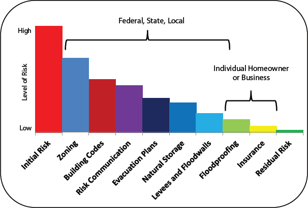
FIGURE 6-1 Examples of tools and measures to reduce and transfer flood risk in flood-prone areas. The remaining risk after these techniques are employed is the residual risk. The bar on the far left indicates the initial, unmitigated risk that is faced by a community. Actions taken through the methods indicated in the subsequent bars, which are illustrative, reduce the unmitigated risk. Some of these actions are taken at the federal, state, and local levels, whereas others are taken by the homeowners and businesses at risk. The risk that remains after these actions are taken (bar on the far right) is the residual risk.
SOURCE: Modified from USACE (2006).
in many cases they face significant risks. As Figure 6-2 illustrates, a structure whose first-floor elevation is at the one percent annual chance level, might suffer only minor consequences should a greater than one percent annual chance flood occur, whereas those behind a one percent annual chance levee might suffer significant consequences. Because there are no federal requirements for land-use restrictions or mitigation in the non-SFHA area, many owners and public officials erroneously assume that the absence of requirements for action can be equated with absence of risk, when in reality, the risk may actually be greater in some areas of the SFHA.
All NFIP communities, because of the land-use regulation provisions for the SFHA, have given some attention to the development of risk management strategies. However, once a levee is accredited, the area behind that levee is considered by most communities to be outside the floodplain and not subject to land-use regulation or requirement for communities to consider the consequences of failure or overtopping. Depending on the topography of the area behind the levee, these strategies consider interior drainage systems to ensure that water “trapped” behind the levee during a storm will not create internal flooding and a SFHA.1
One measure of the potential risk behind levees is measured by the number of structures protected by levees. FEMA currently estimates that 8.6 million housing units (6.5 percent of units in the United States) are located in SFHAs (FEMA, 2012a). The U.S. Army Corps of Engineers (USACE) estimates that there are 14 million structures behind the 14,000 miles of levees for which it has oversight; many of these levees are also accredited under the NFIP (Chapter 8) (Bryan Baker, USACE, personal communication, January 10, 2013). USACE is currently
_______________
1 See 44 CFR §65.10 (b)(6).
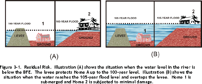
FIGURE 6-2 Scenarios of residual risk. In scenario (A), the levee protects the home up to the one percent annual chance flood. In scenario (B) the water is higher and the one percent annual chance flood overtops the levee. The consequences to Home 1 are more significant than to Home 2: Home 1 is submerged; Home 2 is flooded.
SOURCE: FEMA (2006).
developing a Levee Safety Action Classification (LSAC) for use in screening the results of its inspection of levees under its oversight. Information from the LSAC will be provided to levee owners (USACE, 2012a).
MITIGATION AND RISK TRANSFER MEASURES
Mitigation is defined by the Federal Emergency Management Administration (FEMA) as “sustained action taken to reduce or eliminate long-term risks to people and property from hazards” (FEMA, 2010b). Traditionally, mitigation is divided into structural and nonstructural options. USACE, n.d.a defines structural and nonstructural mitigation measures as follows:
Structural measures such as dams, levees, and floodwalls alter the characteristics of the flood and reduce the probability of flooding in the location of interest. Nonstructural measures alter the impact or consequences of flooding and have little to no impact on the characteristics of the flood.
A portfolio of structural and nonstructural mitigation measures can reduce the likelihood and/or impact of flooding (Table 6-1). For nearly two centuries, the nation relied principally on structural measures to control floods.
TABLE 6-1 Examples of Structural and Nonstructural Flood Mitigation and Risk Transfer Measures
| Structural | Nonstructural |
| Levees | Structure elevation |
| Floodwalls | Natural systems |
| Seawalls | Risk mapping |
| Dams | Hazard forecasting, early warning systems, and emergency plans |
| Floodways and spillways | Dry and wet floodproofing |
| Channels | Land-use planning and zoning |
| Controlled overtopping | Construction standards and building codes |
| Levee armoring | Acquisition and relocation |
| Seepage control | Insurance |
In the mid-20th century, in recognition that even with significant use of structural approaches, flood damages were still on the rise, governments initiated multifaceted floodplain management and expanded use of nonstructural means and risk transfer (flood insurance) mechanisms (Sayers et al., in press).
Structural Mitigation Measures
A brief description of the structural measures most often used in flood control follows, along with discussion about how each of these measures relates to levees. This discussion was adapted, in part, from NRC (2012b).
Levees, Floodwalls, Seawalls, and Other Appurtenant Structures
These structures are designed to prevent floodwaters and storm surges from reaching areas that are at risk. Consequences of failure can be catastrophic because those behind the structure can be subject to rapid inundation and flooding conditions more severe than if the floodwaters had risen gradually.
Dams
Barriers that impound hydrologic flows, dams retain floodwaters before they reach areas at risk. For example, during high-precipitation periods, dams hold upstream floodwaters that are released gradually to minimize the likelihood of damage to downstream communities. However, during exceptionally large events, the storage capacity of a dam can be exceeded and uncontrolled flood flows are passed downstream. Under these circumstances, downstream levees may not be able to contain floodwaters and will fail. This condition occurred in 2011 during spring floods on the Missouri River (USACE, 2012b). Under exceptional circumstances, dams can fail and send significant quantities of water downstream, resulting in damage or destruction of levees and communities below the dams.
Floodways, Spillways, and Channels
Floodways, spillways, and channels are constructed to carry floodwaters around a community or region where the capacity of a river to pass a large volume of floodwaters past a critical location is limited. Under some circumstances, river channels can be modified to increase their flood carrying capacity. During the 2011 flooding of the Mississippi River, USACE opened floodways near New Madrid Missouri to take the pressure off upstream and downstream levees in Illinois, Kentucky, and other locations in Missouri, and three floodways in Louisiana to relieve pressure on structures in the New Orleans area. A similar floodway provides relief when needed to relieve pressure on levees surrounding Sacramento, California.
Structural Mitigation Through Improved Levee Design or Modification
During a flood, levees are under continuous stress that threatens their integrity. The most serious challenges result from wave action against a levee face, the erosion of the land side of a levee as the levee is overtopped or subject to waves breaking over its top, and seepage under the levee that destroys the levee from within. Forms of these occurred during Hurricane Katrina and caused the failure of levees in the New Orleans region in 2005. Use of controlled overtopping, armoring, and underseepage control can greatly reduce the potential for catastrophic failure.
Controlled Overtopping and Breaching of Levees
During a flood event, the risk of a levee overtopping can be significant and the consequences can be catastrophic. Controlled overtopping of levees or engineered overtopping involves designing a levee to force overtopping in the least hazardous location (USACE, 1986). This can be done by using different levee heights, known as superiority, or notches or openings in a desired location (Figure 6-3).
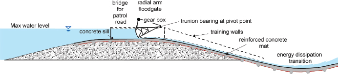
FIGURE 6-3 A gated overflow spillway that would control flows into a desired area.
SOURCE: Courtesy of Jae-won Chung.
The advantages of controlled overtopping in a designated area are (1) reducing the impact of overtopping failure in the selected area and in other parts of the levee system, (2) reducing the likelihood of overtopping in less desirable areas (i.e., areas with more development), and (3) reducing levee maintenance and repair costs after the flood event.
Controlled breaching of levees is occasionally carried out during sustained high flow events (floods), when the benefit of the intentional diversion is deemed to be justified, economically, to mitigate more extensive damage that would likely otherwise occur. Controlled breaches are relatively rare, but have been used in most major flood events since 1927 as a last ditch means to lower flood stages threatening high-value areas, such as New Orleans (in 1927), Cairo, Illinois, and the St. Francis Basin in Missouri and Arkansas 1937 and 2011 along the Mississippi River, or historic towns such as Prairie du Rocher, Illinois, during the 1993 Missouri-Middle Mississippi River flood. These are not to be confused with so-called “forced breaches,” which are routinely employed during floods, usually to help drain flooded tracts of urban or agricultural land. Forced breaches are necessary if there is no other ready means of draining flooded lands that are ringed by intact levees about their lower, or “downstream” perimeters. Forced breaches are usually made using tracked backhoe excavators and are commonly employed whenever a diked tract of land is compromised by flooding. The natural breaches and forced breaches must then be repaired before the succeeding flood season. Since records began being tabulated within the NFIP in 1969, forced breaches have historically accounted for 40 to 50 percent of the post-flooding repair costs sustained by local agencies (Storesund et al., 2009).
Levee Armoring
Armoring a levee involves making a levee less susceptible to erosion induced by floodwaters and overtopping. It involves the use of a variety of materials, from concrete to vegetation. Three key factors in determining levee survival in a significant flood event and overtopping are depth and duration of flow, flow velocity (a function of slope inclination, height of the drop, and flow friction), and the erosive resistance of the vegetation mat and underlying soils (Briaud et al., 2008; Storesund et al., 2009).
The earliest methods of armoring employed in the 1800s, involved timbers reinforcing the submerged wall of the levee. Today, particularly after levees failed in Hurricanes Katrina and Rita in 2005, considerable attention is being given to new methods and technologies that might make earthen levees more survivable during short-term overtopping, as occurs during hurricane-whipped storm surges. These concepts include the use of embedded soil reinforcement (high-density polyethylene mesh and fiber reinforcement), turf reinforcement, and paving land-side slopes with soil admixtures, such as clay, soil cement, and other forms of tensile reinforcement (Rogers, 2009; Xu et al., 2012). An example of one such armored levee is shown in Figure 6-4.
Seepage Berms and Cutoff Walls
Depending on the nature of the material used in the construction of the levee and the foundation of the levee, water may flow through or under a levee creating the potential for collapse of the levee or its foundation (Figure 6-5,
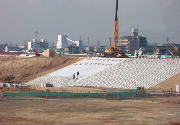
FIGURE 6-4 Example of an armored levee in Japan.
SOURCE: Courtesy of Gerald E. Galloway.
Top). Cutoff walls and trenches can be used to stop the flow through and below a levee (Figure 6-5, Lower Left). Construction of land-side seepage berms can add sufficient weight to counteract the upward seepage forces (Figure 6-5, Lower Right). Pressure relief wells can be placed on the land side of the levee to deal with seepage and are part of the levee repair effort for the East St. Louis, Illinois levees mentioned in Chapter 5.
Nonstructural Mitigation Measures
Nonstructural measures vary in cost and effectiveness and the physical and political effort required to implement them. The selection of which measure to use is a function of the location in which it will be employed (topography, expected flood levels, etc.), the availability of funds, and public acceptance of use.
Structure Elevation
By raising a structure above the expected flood level, flood damages can be prevented (Figure 6-6). Behind an accredited levee, if a flood greater than the one percent annual chance flood occurs, there could be some damage to such elevated properties but considerably less than if the structures had been at the base flood elevation (BFE). In the SFHA, buildings are elevated to the BFE in the case of new construction, substantial improvements are made to existing buildings, and repairs are made to substantially damaged buildings to comply with the NFIP (FEMA, 2000). NFIP insurance rates for structures in the SFHA are discounted for elevations above the BFE, providing that supporting documentation (i.e. an elevation certificate) is provided.
Elevation includes moving key or essential equipment from low-lying elevations within a structure to areas that would not be subject to flooding. Having building support systems such as computers, heating and air-conditioning units, and electrical stations located in the basement areas puts the functionality of the entire building
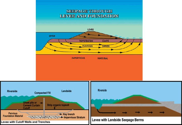
FIGURE 6-5 Levee seepage and control methods. (Top ) Seepage paths under and through a levee. (Lower Left) Use of cutoff walls and trenches to block seepage. (Lower Right) construction of a land-side seepage berm to provide additional weight and length to counteract upward seepage forces.
SOURCE: USACE Management Measures Digital Library. Available online at http://www.iwr.usace.army.mil/docs/MMDL/FLD/Feature.cfm?ID=5, accessed January 25, 2013.
at risk during a flood event. In 2006, a heavy storm in downtown Washington, D.C. flooded much of the federal triangle including the National Archives, the Federal Bureau of Investigation Headquarters, and the basement of the Internal Revenue Service (IRS), damaging essential mechanical and electrical equipment. The IRS was closed for 6 months to allow for repairs (GAO, 2007; National Capital Planning Commission, 2008).
When building a structure on the floodplain, the cost of incorporating freeboard in a pile or a masonry pier foundation averages approximately 1 to 2 percent of the at-BFE building cost for 4 feet of added freeboard. For a masonry wall with interior pier (crawlspace) foundation, the cost averages 3 to 6 percent of the at-BFE building cost (Jones et al., 2006). Jones and colleagues (2006) concluded that it is financially reasonable to spend between 103 to 106 percent of the at-BFE building cost to elevate a structure, depending on local circumstances.
Challenges in elevating structures do exist. For example, properties that service people with disabilities may require either an elevator or a long ramp, the cost of which could make elevation economically infeasible. In addition, there is growing concern that having an entire community elevated creates the potential for small islands (houses) in a flood sea that cannot be accessed during the flood event. In the case of fire or a medical emergency, first responders would find it very difficult to reach many of these homes. If flooding were to last for an extended period, the elevated homes would rapidly become uninhabitable.

FIGURE 6-6 Elevated homes behind levees in New Orleans, Louisiana.
SOURCE: Courtesy of Gerald E. Galloway.
Natural Systems
Naturally existing, restored, or developed wetlands, as well as land in periodic cultivation, can store overflow waters from riverine flooding and help reduce downstream impacts. Wetlands also provide a natural barrier to storm surge inundation. Coastal sand dunes protect structures built behind them and help slow down coastal erosion and also the immediate impact of rising storm surge. Floodways built to relieve flood pressure can also provide ecosystem benefits. These natural systems can be effective in reducing flooding behind levees with interior drainage problems (Galloway et al., 2009; Opperman et al., 2009). Use of natural systems typically requires some form of real estate acquisition (fee simple, easement, payment for use, etc.) because the benefits from such measures normally do not accrue to the individual who may own the property required. In some cases, there will be a need for construction of appropriate inlet and outlet works to permit the entry and exit of stored waters.
Risk Mapping
Accurate mapping of risks provides those living or working in flood-prone areas, in front of or behind levees, with the information necessary to make rational decisions in developing their personal or corporate flood risk management strategies. Risk mapping is discussed further in Chapter 7.
Combining the natural hazard risk assessment with quantitative consideration of mitigation measures yields expected outcomes that can be graphically portrayed in a manner that facilitates public understanding of the risk and its implications for them.
NRC (2012b)
Hazard Forecasting, Early Warning Systems, and Emergency Plans
Detailed weather forecasts of the path and severity of a tropical storm, and accurate predictions of stages (heights) of flooding rivers enable government officials and the public to make decisions to evacuate or move valuable property from high-hazard areas. Advance information about potential failures of levees or dams can significantly reduce the consequences should failures occur. Preparation of emergency action and evacuation plans can similarly reduce or eliminate casualties and property losses.
Dry and Wet Floodproofing
Damage to structures in the SFHA and behind levees can be greatly reduced through effective dry and wet floodproofing. Dry floodproofing seals structures to prevent floodwaters from entering; wet floodproofing makes uninhabited portions of a structure resistant to floods by allowing water to enter and flow through the structure during a flood. FEMA defines floodproofing as
a combination of adjustments and/or additions of features to buildings that eliminate or reduce the potential for flood damage. Examples of such adjustments and additions include anchoring of the building to resist flotation, collapse, and lateral movement; installation of watertight closures for doors and windows; reinforcement of walls to withstand floodwater pressures and impact forces generated by floating debris; use of membranes and other sealants to reduce seepage of floodwater through walls and wall penetrations; installation of pumps to control interior water levels; installation of check valves to prevent the entrance of floodwater or sewage flows through utilities; and the location of electrical, mechanical, utility, and other valuable damageable equipment and contents above the expected flood level (FEMA, n.d.a).
The Federal Alliance for Safe Homes (FLASH) indicates that dry floodproofing can be accomplished by measures such as
• Applying a waterproof coating or membrane to the exterior walls of the building;
• Installing watertight shields over doors, windows and other openings;
• Anchoring the building as necessary so that it can resist floatation;
• Installing backflow valves in sanitary and storm sewer lines;
• Raising utility system components, machinery and other pieces of equipment above the flood level;
• Anchoring fuel tanks and other storage tanks to prevent flotation;
• Installing a sump pump and foundation drain system;
• Strengthening walls so that they can withstand the pressures of floodwaters and the impacts of flood borne debris;
• Construct nonsupporting, break-a-way walls designed to collapse under the force of water without causing damage to the house or its foundation.2
Wet floodproofing includes construction of veneers to seal potential water entry into or under a structure, installation of vents to allow water to move through crawl spaces under homes (avoiding different water levels outside and under a home).3 Floodproofing can also include permanent or temporary installation of barriers such as modular dams and small levees designed to keep floodwaters away from one or more structures for limited periods of time (Figure 6-7).
There is an increasing demand for products and techniques that can be used in existing properties to reduce the potential damage when flooding occurs. To ensure that floodproofing products are well designed and manufac-
_______________
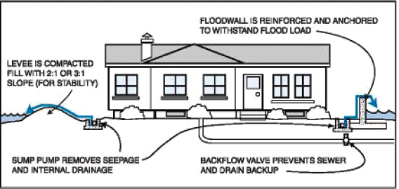
FIGURE 6-7 Barriers and small levees floodproof a home from low-level flooding.
SOURCE: FEMA (2007).
tured to perform the task for which they are being developed, both the Association of State Floodplain Managers (ASFPM) and FM Global have developed certification standards to support this need (FM Global, 2006, n.d.).4
Land-Use Planning and Zoning
Wise land use is at the center of nonstructural flood mitigation activity and is an effective tool for reducing risk at the community level. Land-use planning implements public policy to direct how land in a given area is used. It is executed through zoning ordinances and takes place on multiple levels of government, from national policy to local policy where there may be designation of parcels for a specific use at the local level. When appropriate, wise land use may mean a lack of investment in a particular area (Box 6-1).
Few issues have gained attention and controversy like land-use planning. The tension between promoting development in order to foster growth in the community and the potential long-term liabilities (i.e., flood risk) is significant. Unfortunately, when individuals or businesses develop an area that may be subject to flooding and are unaware of the potential risk, these individuals suffer when a flood event occurs. Although the NFIP requires regulation of the land within the SFHA, it does not require flood-prone communities to regulate areas beyond the one percent annual chance flood level or areas behind levees even though both areas face flood risks. When a community’s land-use plans treat all areas behind a levee the same way even though some areas are substantially below the BFE and would be fully inundated in the event of a major levee failure, these land-use plans ignore the risk in placing occupants of the lower areas at an economic and safety disadvantage.
Construction Standards and Building Codes
Construction standards and building codes can be developed at any level of government but they are enforced at the local level. While codes provide for public safety, they also prescribe practices and measures that directly address known causes of disaster damages. Damages can be significantly reduced by attention to modern construction standards and building codes. Kunreuther (1996) found that one-third of the damages associated with the 1992 Hurricane Andrew could have been avoided had Florida enforced its building codes.
_______________
4 See http://www.floods.org/index.asp?menuid=421&firstlevelmenuid=183&siteid=1.
BOX 6-1
The Coastal Barriers Resources Act
Coastal barriers possess many characteristics that make them attractive building sites. These include their rich biological diversity, their status as popular vacation destinations, and their role as large drivers to local economies. However, these areas pose substantial risks to both developers and homeowners. They are often the location of first landfall by tropical storms, bearing the full force of storm surges and hurricane winds, and are the victim of a constantly fluctuating landscape due to chronic coastal erosion (FWS, 2002). The federal government historically subsidized and encouraged development in these coastal areas until the late 1970s and early 1980s, when it was realized that this subsidization and encouragement had been resulting in the loss of natural resources; presented a threat to human life, health, and property; and cost American taxpayers millions of dollars each year (FWS, 2012).
In an effort to remove any federal incentive to develop on coastal barriers, Congress passed the Coastal Barrier Resources Act (CBRA) in 1982. Reauthorized in 1990, the CBRA designated relatively undeveloped coastal barriers along the Atlantic and Gulf coasts, the Florida Keys, the Great Lakes, Puerto Rico, and the U.S. Virgin Islands as part of the newly created John H. Chafee Coastal Barrier Resources System. This designation renders these coastal barriers ineligible for most new federal expenditures and financial assistance, including, most significantly, access to federal flood insurance through the NFIP (FWS, 2012). Although no longer encouraged by the federal government, development in these hazardprone areas is not prohibited, provided any work and investment is made by private developers and other nonfederal parties. In return for a lack of restrictions on development, any individual or developer choosing to live and invest in these areas agrees that they will bear the full cost of development and rebuilding (in the case of a flooding event or other natural disaster) instead of relying upon federal funding for roads, wastewater systems, potable water supply, and disaster relief (FWS, 2012). This approach has saved over $1 billion in federal dollars between 1982 and 2010 and is expected to continue saving federal dollars in the future (FWS, 2012).
Acquisition and Relocation
Acquisition or relocation of properties that are repetitively flooded, substantially damaged, or need flood-related project construction have been supported by FEMA and USACE, allowing many communities to deal with the challenges of these frequent flood losses. When land is not suitable or only marginally suitable for development or agricultural activity, that land can be acquired and placed into public use for either environmental or recreational purposes to enhance the overall quality of life in the community. Buyouts of properties that are repetitively flooded have been supported by FEMA and have allowed many communities to deal with frequent flood losses.
Although a few sections of communities have been relocated, more relocations or removals usually take place where specific parcels are identified as being at risk. When property is acquired for environmental purposes. this land can frequently be used during flood periods for off-river storage of floodwaters. This flood storage reduces the downstream impact of the flood and the area is restored after the flood to its previous condition. During the 2011 Mississippi River floods, over 500,000 acres of land in the lower Mississippi Valley was used for flood storage, which dramatically reduced river stages that otherwise would have affected large communities such as New Orleans and smaller ones such as Cairo, Illinois.
Insurance
Through the purchase of insurance, some of the financial risk of living on a floodplain in or outside the SFHA or behind a levee is transferred, for a premium, from the individual to the entities that provide insurance. Floodplain managers tend to consider this a mitigation technique, when in fact unlike physical measures that reduce damages,
insurance does not reduce damages but simply compensates the affected parties for these losses. In most floodprone areas in the United States, this insurance is provided to residential properties and small businesses through the NFIP. Commercial flood insurance is available and is issued by numerous major insurers and is issued by a worldwide network of reinsurance organizations, providing coverage for property value in excess of the NFIP maximum of $250,000 for residential property and $500,000 for businesses. However, unlike the NFIP, commercial insurance rates and rates for homeowner coverage in excess of the NFIP cap are based on more detailed analysis of properties as they apply for coverage and may reflect more sophisticated risk analysis and requirements for mitigation measures (Chapter 5).
When property owners take steps to mitigate potential losses through use of mitigation measures, commercial insurers typically will reduce the premiums to reflect the risk mitigation. The NFIP provides premium reductions in the SFHA in two cases, for elevation of property higher than the BFE and some types of commercial property floodproofing. However, the NFIP does not provide premium reductions in areas behind levees (preferred risk policies). When risk-based pricing is implemented, discounts for mitigation measures behind levees need to be considered because it is likely that, in many cases over the life of a mortgage, the premium discounts could exceed the costs of the mitigation and would be beneficial to the mortgage holder and the mortgagee.
The perception exists that flood insurance is unnecessary for individual homeowners in the floodplain because, after a flood event, government and private agencies assist the property owners in getting back on their feet. Media statements and political rhetoric regarding disaster aid imply generous aid to repair and replace property. Analysis has indicated that this is not necessarily the case (Kousky and Shabman, 2012). Possession of an insurance policy provides rapid payment to the owner of claims for property damage and gives those with insurance the ability to recover much faster than those seeking to piece together other forms of assistance, which, in the long run, will not make up the entirety of losses.
DEVELOPING COMMUNITY STRATEGIES FOR AREAS BEHIND LEVEES
Circumstances produce a variety of flood risk scenarios behind levees. These circumstances can include anything from proximity to the coast or river, local weather patterns, existing infrastructure, and community preparedness. Some risk scenarios are associated with long time horizons, such as flooding associated with climate change, and might be less perceptible to the at-risk community compared with, for example, a design deficiency in a levee discovered during the Map Modernization process. Complicated scenarios arise as communities grapple with unique situations (Box 6-2). A mix of flood risk management measures tailored to the risk of a particular
BOX 6-2
Challenges to Mitigation and Flood Management: Norfolk, Virginia
Living in an area that is vulnerable to flooding, the community of Norfolk, Virginia, has spent years wrestling with flood risk. Home to the world’s largest naval base and 1.7 million people, even high tides or heavy rains can cause problems for this low-lying port at the mouth of the Chesapeake Bay. Challenging issues such as the combination of sea level rise and subsidence dramatically changing the level of the ocean in Norfolk face this community (Figure 6-8; Boon et al., 2010).
The current flood management system of Norfolk consists of pumping stations and floodwalls. Each year, the city invests in improving drainage and elevating roads. Norfolk has taken additional steps to prepare for flooding, including hiring a Dutch coastal engineering firm to conduct a vulnerability analysis to enhance mitigation and inform development. This new strategy includes, for example, new floodgates, pumping stations, and floodwalls at an estimated cost of $1 billion dollars (NPR, 2012). This strategy also includes something called “managed retreat” by Mayor Paul Fraim, saying that the cost of flood mitigation is sometimes too steep and giving up homes makes more sense (NPR, 2012).
community paired with an appropriate communication strategy is the most effective flood risk reduction strategy (Burby and Dalton, 1994; Brody et al., 2007; Sayers et al., in press; see also Figure 3-3 in Chapter 3).
Flood Risk Management Strategy: Goals at the Local Level
To successfully develop a flood risk management strategy, a community, in collaboration with those entities that may be called upon to assist in the implementation of the strategy, needs to first establish the goals of the strategy. This collaboration requires the community to synchronize planning with relevant regional bodies and ensure its conformance with state and federal guidelines and regulations when they exist. A critical part of the goals of the strategy is to define the relative levels of protection both in front of and behind levees and then to lay out the appropriate combination of mitigation measures (structural, nonstructural, or insurance) to achieve those levels.
Today, there is no national standard for level or degree of protection for flood-prone communities, except for those choosing to participate in the NFIP. Under the NFIP, those in the SFHA must take action to mitigate against the one percent annual chance flood. Those behind levees must ensure that the levees protect against the one percent flood. However, this criterion is a standard for participation in the insurance program, not a life-safety or property protection standard. Since the decision was made in the 1970s to use this one percent standard for NFIP accreditation, the predominance of the written reports concerning levees have argued for a minimum standard of 0.2 percent annual chance for levees protecting urban areas (see Chapter 2 and Appendix F).
As indicated in Chapter 2, when the federal government began to build levees under its flood control authorities, it began with relatively high standards. Urban area levees and those protecting the Lower Mississippi Valley were to be built to pass a standard project flood or higher level flood. Agricultural areas were typically protected to near the 2-3 percent annual chance level. Executive Order 11988, March 1977, directed federal agencies supporting activity in the floodplain to require critical facilities to be located outside the 0.2 percent floodplain or be elevated above that level, but few similar requirements were imposed by state governments.
In 1973, the U.S. Water Resources Council issued Principles and Standards (WRC, 1973), which established national and regional economic development, environmental quality, and other social effects as criteria for evaluation of federal water resource projects. These standards permitted a variety of justifications for level of protection to be considered. In 1983, the WRC established, in Principles and Guidelines, national economic development as the single objective (WRC 1983) and it quickly became apparent that the optimum level of protection for a levee given the economic benefits was at or near the one percent level because reaching that level created the “benefit” of not having to buy insurance when located behind such levees. Life safety was not a consideration in the calculus.5
In 2007, the State of California legislated that new urban levees would have to be constructed at the 0.5 percent (200-year) level as a result of evaluation of the flood risks facing the state and the lessons learned from Hurricane Katrina. This represents a critical evolution in thinking—that it is appropriate to tailor flood risk management strategies to individual communities, geographic areas, or watersheds by carefully selecting a level of protection that reflects the life safety and economic assets in a given area. This includes recognition that the one percent annual chance flood standard of the NFIP might not serve as an appropriate life safety or property protection standard. Also critical to evaluating flood risk management strategies at the local level is the ability to acquire the resources it will need to carry out the floodplain management strategy.
Development of a flood risk management strategy focused solely on protection of areas behind levees would be neglecting the comprehensive nature of the flood risk challenge. It is critical to coordinate efforts to deal with one part of the floodplain with planning and other areas. Also critical is the consideration of all types of development and activity in local land-use plans, including residential, commercial, industrial, and agricultural needs of the community, placement of these components in a community, and an economic analysis of the costs and benefits of the flood risk management strategies being examined. Do the benefits to be gained merit the commitment of the
_______________
5 In the 2007 Water Resources Development Act, Congress directed the revision of Principles and Guidelines to include “(1) seeking to maximize sustainable economic development; (2) seeking to avoid the unwise use of floodplains and flood-prone areas and minimizing adverse impacts and vulnerabilities in any case in which a floodplain or flood-prone area must be used; and (3) protecting and restoring the functions of natural systems and mitigating any unavoidable damage to natural systems.” To date the revision has not occurred.
resources needed to carry out the floodplain management strategy? However, approval of community participation in the NFIP and accreditation of levees in these communities is not dependent on the cost-effectiveness of the levee or other mitigation measures incorporated in the community flood risk management strategy. Economic decisions are more closely tied to the analyses conducted by federal or state agencies to meet the criteria for participation in or construction of flood-related infrastructure under other government programs.
Future Conditions and Climate Change
Actions to shape flooding in one location can have impacts on flood stages (i.e., flood risk scenarios) at other locations, a realization that first surfaced in the late 1800s and early 1900s in the Sacramento River Basin, California. At the time, ad hoc levee construction generated significant, unintended hydrologic impacts at both the local and regional levels, driving the state to eventually implement statewide flood control measures through a State Reclamation Board. Today, this issue still plagues the Sacramento-San Joaquin Delta area, and a Central Valley Flood Protection Plan was adopted in June 2012. This plan promotes integrated, systemwide wise flood management, a key implication of which is that flood management investments (e.g., levees) will not result in an increased risk of flooding in other areas (CVFPP, 2012).
Community flood risk scenarios will continue to evolve as change occurs. Climate change will have a variety of regional impacts, and the geographic location of a community will affect how changing conditions affect risk. Some areas will have more droughts, some will have more frequent floods, and others will have more intense floods. Research to understand these hydrologic changes is ongoing (NRC, 2011, 2012a). A recent special report of the Intergovernmental Panel on Climate Change (IPCC, 2012) indicates a likely increase in many regions of the frequency of heavy precipitation events, and when coupled with increasing vulnerability presents a myriad of challenges for coping with climate-related disastersIPCC. Galloway (2009) cites 11 major international studies conducted from 1987 to 2002 that all predict significant climate change-induced hazards, including increased flooding, higher mean atmospheric temperatures, higher global mean sea levels, increased precipitation, increased strength of storms, more energetic waves, storm surges that reach further inland, undercapacity of urban sewerage and drainage systems, increased vulnerability of port cities, and disproportionate impacts on disadvantaged population segments (Galloway, 2009). The rise in sea level and the increase in storm surge due to climate change puts many coastal areas at risk from intensified flooding (NRC, 2010).
Hirsch and Ryberg (2012), in examining trends in annual floods at 200 stream-gauge sites in the United States, found that, while there appeared to be no strong statistical evidence for flood magnitudes increasing with increasing global mean carbon dioxide concentration, there were differences in flood magnitudes among the four quadrants of the conterminous United States (Figure 6-8). They indicate that the attention should be paid to the effects of changes in the relative “importance of the role of snowpack and rain on snow events.” Raff (2013) suggests that the increase in magnitude of floods in the northeastern and midwestern United States (Figure 6-9, upper Right), may have consequences in the Upper Mississippi, Ohio, and Missouri watersheds (Hirsch and Ryberg, 2012; Raff, 2013).
The Draft National Climate Assessment, issued in January 2013 by the National Climate Assessment Development Advisory Committee, begins with the statement:
Climate change is already affecting the American people. Certain types of weather events have become more frequent and/or intense, including heat waves, heavy downpours, and, in some regions, floods and droughts…. The largest increases have occurred in the Northeast, Midwest, and Great Plains, where heavy downpours have exceeded the capacity of infrastructure such as storm drains, and have led to flooding events and accelerated erosion.
The report goes on to point out the increasing vulnerability to flooding of those in floodplains and coastal areas (Figure 6-10; NOAA, 2013). For example, prior to Hurricane Sandy, FEMA, as part of its continuous updating of FIRMs had begun revision of FIRMs for the New York Metropolitan Area and had planned to deliver them to state and local officials in mid-2013 for comment. When Hurricane Sandy hit New York, FEMA accelerated the release of information about the BFEs that would be seen on the new maps so that individuals and community officials could plan the recovery and reconstruction accordingly. These advisory BFEs for A and V zones, now in the hands of officials and the public, reflect the anthropogenic and physical changes that have taken place in the
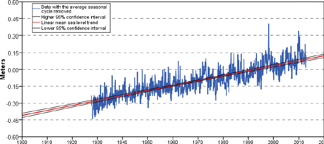
FIGURE 6-8 Average sea level trend at Seawells Point, Virginia, recording a 4.44-mm/year rise with a 95 percent confidence interval of ±0.27 mm/year based on data from 1927 through 2006. This is equivalent to 1.46 feet in 100 years. Data from NOAA’s Seawells Point monitoring station.
SOURCE: http://tidesandcurrents.noaa.gov/sltrends/sltrends_station.shtml?stnid=8638610 Sewells Point, VA.
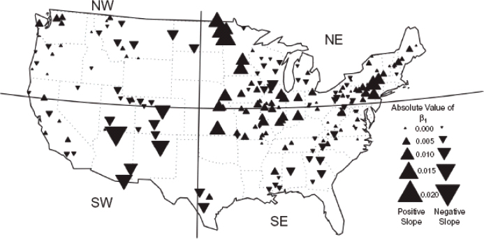
FIGURE 6-9 Areas of increases and decreases in flood magnitude trends at 200 U.S. Geological Survey stream gauge stations. Upward pointing triangles represent increases in the magnitude; downward pointing triangles, decreases.
SOURCE: Hirsch and Ryberg (2012).
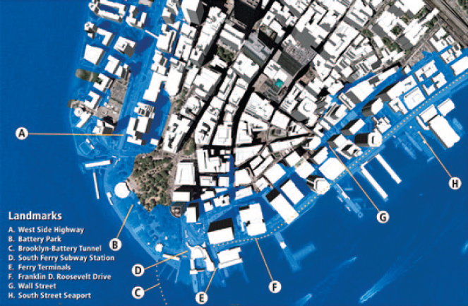
FIGURE 6-10 The challenge of rising sea level and the expansion of the one percent annual chance floodplain to New York City. The light blue area represents a 2012 depiction of the one percent annual chance floodplain of Lower Manhattan, New York City. With sea-level rise, a far larger area would be flooded in the event of a one percent annual chance flood event. (Note that flooding during Hurricane Sandy (2012) exceeded the one percent annual chance flood.) With sea-level rise, the one percent annual chance flood will inundate a larger area of New York City (not pictured here).
SOURCE: USGCRP (2009).
over 25 years since many of the maps had been developed; the new BFEs range from 2 to more than 10 feet higher than previously depicted on FIRMs. Attention to these new elevations will ensure that those who were damaged by Sandy will be able to rebuild or relocate knowing more about the 2013 hazard they face (FEMA, 2013; Jeffrey Woodward, FEMA, personal communication, February 27, 2013).
A soon-to-be-released FEMA study of the impacts of climate change and population growth on the NFIP indicates that the size of the nation’s floodplains will grow between 40 and 45 percent over the next 90 years and double the number of needed flood policies by the end of the century (Figure 6-11). It is speculated that this will require FEMA to incorporate the effects of climate change in the operation of the NFIP (Lehmann, 2011). Under current regulations, FEMA does not include consideration of future conditions in development of FIRMs.
The 2012 Biggert-Waters Act established a Technical Mapping Advisory Council to serve as an advisory body dealing with map modernization issues.6 The legislation directs the Council to:
consult with scientists and technical experts, other Federal agencies, States, and local communities to (A) develop recommendations on how to (i) ensure that flood insurance rate maps incorporate the best available climate science to assess flood risks; and (ii) ensure that the Federal Emergency Management Agency uses the best available methodology to consider the impact of (I) the rise in the sea level; and (II) future development on flood risk; and (B) not
_______________
6 Section 100215.
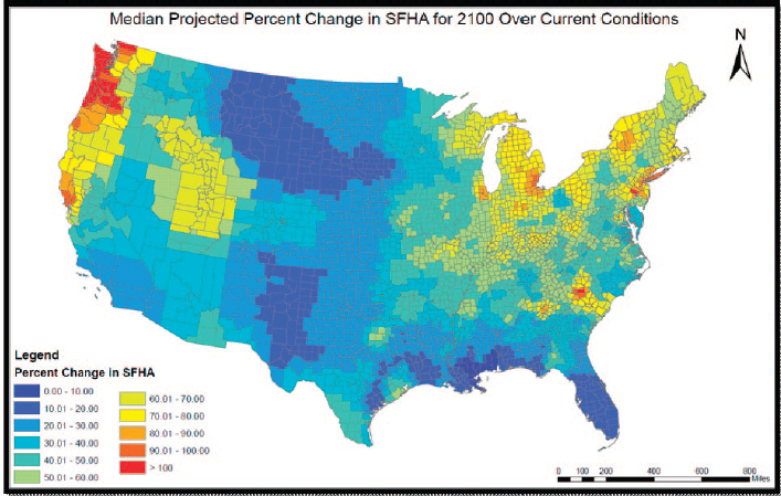
FIGURE 6-11 The average projected percent change in the size of the Special Flood Hazard Area by the year 2100 as a result of climate change and demographic change, in counties across the United States.
SOURCE: Crowell (2010).
later than 1 year after the date of enactment of this Act, prepare written recommendations in a future conditions risk assessment and modeling report and to submit such recommendations to the Administrator.
The Biggert-Waters Act further charges the Administrator to review and update NFIP rate maps and to incorporate any future risk assessment submitted by the Technical Mapping Advisory Council in any such revision or update.7
Implementing Flood Risk Management
Flood risk management begins with goal and policy development, identification of the hazard, analysis that includes assessment of the hazard’s potential impact, and development of flood risk management strategies, representing the amalgamation of the various measures discussed in this chapter and Chapter 7 available to deal with the flood challenge (Figure 3-3). Flood risk management strategies are represented by portfolios of mitigation measures. A structural approach—that is, construction of a levee—is immediately visible and for many flood events provides adequate mitigation of the effects of rising waters. Implementation of nonstructural mitigation approaches is not always well received. Efforts to promote wise development or enhance building codes are sometimes seen as efforts to limit growth and reduce economic vitality in the affected area. Requiring communities to elevate homes can be seen as creating visual blight and similarly reducing the economic utility of the property. Less thought is given to the potential economic consequences should a flood actually occur. Federal project development guidance makes structural projects more feasible and requires less contribution from local governments for their execution
_______________
7 Section 100216.
than would be expected of nonstructural efforts. Simply looking at an economic balance sheet tilts decision making toward structural approaches.
Successful flood risk management strategies are developed through a bottom-up process that is supported from the top down. Development of flood risk strategies by the community is critical, as is support from and collaboration with FEMA (Box 6-3) and other federal and state agencies. FEMA supports mitigation projects through a variety of hazard mitigation assistance (HMA) grants, administered through several programs that provide funding for eligible activities that reduce disaster loss and protect life and property from future damages. For example, FEMA supports mitigation projects through the Hazard Mitigation Grant Program (HMGP), a program that provides state and local government with grants for projects that reduce or eliminate losses of life and property from future disasters. Projects include elevation of a home, purchase of property subject to repetitive damage, and retrofitting, etc. HMGP grants may address a variety of risks and are not limited to flood risk; grants are only available to those in a presidentially declared disaster area and can be significant. FEMA also issues flood mitigation assistance (FMA) grants, severe repetitive loss (SRL) grants, and repetitive flood claim mitigation (RFC) grants, and pre-disaster mitigation (PDM) grants. FMA, SRL, and RFC grants are designed to, over time, reduce flood losses to the NFIP by mitigating insured properties with particular attention to repetitive loss and severe repetitive loss properties. PDM grants provide support for multihazard mitigation (planning and project implementation) prior to a disaster event (FEMA, n.d.b).
Mitigation projects that are eligible for HMA assistance include, for example, property acquisition, structure elevation, dry floodproofing, and minor flood control projects, such as the installation or modification of culverts, and stormwater management activities such as creating retention and detention basins. Ineligible projects generally include major flood control projects such as “construction, demolition, or repair of dams, dikes, levees, floodwalls, seawalls, groins, jetties, breakwaters, and erosion projects related to beach nourishment or re-nourishment,” that is, projects where catastrophic failure is a possibility and the potential for loss of life and property is too great (FEMA, 2010a; Ryan Janda, FEMA, personal communication, January 29, 2013). Collectively, these grant programs become important parts of the risk management portfolio.
Communities behind levees are diverse in their physical and social characteristics. They have different types of flood risk that require a combination of risk management measures targeted at households, neighborhoods, and regions. They face a rapidly changing future, and a one-size-fits-all solution is not sufficient to adequately manage risk for all communities across the nation. The National Research Council report, Disaster Resilience: A National Imperative (NRC, 2012b), points out that informed decision making is key to managing risk. The development of information using a modern risk analysis tools will allow communities to utilize specific information in designing risk reduction strategies specific to that community and to visualize the risk throughout the communities over time.
BOX 6-3
Project Impact
Initiated in 1997, FEMA’s Project Impact provided training and funding for disaster mitigation activities (flood, earthquake, fire, etc.) and facilitated the establishment of local partnerships in the community to mitigate the impacts of these disasters. The program established responsibility and authority for disaster mitigation at the community level. The program goals were accomplished by establishing responsibility and authority for mitigation at the community level. The actions were organized into four phases: (1) building partnerships, (2) identifying hazards and community vulnerability, (3) identifying and prioritizing risk reduction actions for the community, and (4) communicating success (FEMA, 1997).
Project Impact was discontinued at the federal level in 2001. However, some communities continued partnerships and mitigation activities where Project Impact was the catalyst for a long-term disaster management approach. Project Impact remains today a good model for encouraging and implementing community resilience.
Sayers et al. (in press) point out that risk-based methods enable uncertainty to be explicitly recognized and data collection prioritized to address areas where the lack of uncertainty is material to the choices being made. With science as the foundation of flood management measures, “better information leads to better decision-making and better flood management” (Schropp and Soong, 2006). With better knowledge, decisions makers can make land-use and other decisions that lead to reductions in loss of life and property damages (Brody et al., 2011).
Most communities participating in the NFIP focus their attention on those areas within the SFHA and overlook the risk to those outside the SFHA, especially those areas behind levees. There is a clear need for a comprehensive, tailored approach to risk management behind levees that (1) is designed and implemented at the local level; (2) involves federal and state agencies, communities, and households; (3) takes into account possible future conditions; and (4) relies on an effective portfolio of structural measures, nonstructural measures, and insurance to reduce the risk to those behind levees.
To reduce the flood risk to those behind levees, FEMA should encourage communities to develop and implement multimeasure risk management strategies for areas behind accredited levees. This strategy would contemplate the full range of foreseeable flood scenarios including levee overtopping or failure. The development of new risk management analysis tools will facilitate the identification of risks and suggest feasible approaches to dealing with the risks to those behind levees.
EFFECTIVE FLOOD RISK MANAGEMENT: ADMINISTRATION OF LEVEES
Development and maintenance of appropriate supporting policies and data affecting the portfolio of mitigation measures are both critical effective floodplain management strategies. For example, managing the inclusion of levees in the NFIP is an important mission of the Federal Insurance and Mitigation Administration and requires the development of policies and procedures as well as regulatory instruments. Furthermore, data on the extent and status of the nation’s levees are critical to informing all stakeholders of the extent of flood risk and developing appropriate floodplain management strategies. This section addresses both the current status of and the need for revision to the principal regulatory document establishing procedures for inclusion of levees in the NFIP and efforts to develop and maintain a national inventory of levees.
Levee-Related Federal Regulations
Title 44 of the Code of Federal Regulations (CFR) contains several sections pertaining to levees in the NFIP including:
• 44 CFR §59.1, Definitions;
• 44 CFR §64.3, Flood Insurance Maps; and
• 44 CFR §65.10, Mapping of Areas Protected by Levee Systems.
Section 65.10 describes the “types of information FEMA needs to recognize, on NFIP maps, that a levee system provides protection from the base flood,” and serves as the principal guidance document for levee development and certification.
The committee considered the three aforementioned sections of the CFR during the course of deliberations. The committee was asked specifically for advice on “Existing requirements for levee accreditation under 44 CFR §65.10” (Box 1-4). All three sections are relevant to the charge of this committee in the sense that Section 65.10 relies on the information contained in Sections 64.3 and 59.1. As indicated in Chapter 2 and Appendix F, the 2006 Interagency Levee Policy Review Committee (ILPRC) report to FEMA also addressed these three sections of Title 44, and the committee’s advice generally supports the recommendations of the ILPRC.8
_______________
8 The changes to Title 44 recommended by the ILPRC have yet to be acted upon by FEMA.
44 CFR §59.1, Definitions
In the past, existing roads and railroads, that is, embankments, were assumed to be included in the definition of a levee system and its accreditation even though the information concerning the integrity of the structures was unknown. As defined in 44 CFR §59.1, a levee system is: “a flood protection system which consists of a levee, or levees, and associated structures, such as closure and drainage devices, which are constructed and operated in accordance with sound engineering practices” (emphasis added). Although such embankments can provide a degree of flood protection, they can also be the source of catastrophic failures. If embankments are to be included in a levee system, they need to be subject to the same examination as levees designed specifically for flood protection purposes or the definition modified to exclude them because they were not designed to provide risk reduction from flood damages (ILPRC, 2006).
44 CFR §64.3 Flood Insurance Maps
Under current procedures, areas behind accredited levees are normally shown as Zone X or a shaded Zone X with the latter frequently indicating the presence of a levee. Section 64.3 identifies Zone X as either an area “of moderate flood hazards or areas of future-conditions flood hazard” or an area “of minimal hazards.” FEMA’s Map Service Center indicates that a shaded Zone X is an “Area of moderate flood hazard, usually the area between the limits of the 100-year and 500-year floods. Are also used to designate base floodplains of lesser hazards, such as areas protected by levees from 100-year flood, or shallow flooding areas with average depths of less than one foot or drainage areas less than 1 square mile” (Appendix E). Neither of these definitions adequately identifies areas behind accredited levees. Establishing a unique zone designation for areas behind levees would more clearly distinguish areas behind accredited levees from the 0.2 percent annual chance floodplain and the one percent annual chance floodplain and would provide clarity and assist in risk communication (ILPRC, 2006).
44 CFR §65.10, Mapping of Areas Protected by Levee Systems
If the definition of a levee system in 44 CFR §59.1 is modified to specifically exclude embankments, such as roads and railroads that were not engineered to provide risk reduction from flooding, similar modification of 44 CFR §65.10 is necessary (ILPRC, 2006). This would ensure that nonengineered levee systems are not certified as providing protection from the base flood.
As part of periodic update of FRIMs (map modernization), all levees are being subjected to analysis as they are mapped. Even though the map modernization program has a high priority, at current resource levels, the period between updates may be lengthy. It is important that, independent of the mapping of levees, FEMA maintain some degree of surveillance over the integrity of levees in the NFIP (ILPRC, 2006). At present, once accredited, a levee maintains this status until the next update. Rather than allowing accreditation to remain in effect until the FIRM is revised, periodic submission of operation and maintenance records as well as a written assessment of the levee systems performance in any flood events that have occurred to FEMA is needed. Furthermore, periodic recertification of the engineering and geotechnical aspects of the levee is critical. These continued actions verifying to FEMA that an accredited levee maintains its integrity would require modification of 44 CFR §65.10.
The design of levee systems is based on conditions at the time of the design including the flow and channel carrying capacity. As a result of upstream activity or normal geomorphic processes, the flow can be increased and the carrying capacity of these channels can be significantly reduced, thereby increasing the elevation of the base flood and reducing or eliminating the capability of an accredited levee to pass the base flood. Attention to the maintenance of these channels is an important part of maintaining the integrity of the levee system. Assurance that the flood carrying capacity of the main river channel is maintained is critical. Channel maintenance preserves the required level of protection, ensures that encroachments are controlled, and that an increased flow does not affect the integrity of the levee or the ability of the levee sponsor to maintain the levee and fight floods, when necessary (ILPRC, 2006).
To ensure that levees are designed to meet widely recognized standards, FEMA, in the past, has included references to the appropriate USACE manuals.9 During the establishment of the NFIP and the inclusion of levees in the program, FEMA worked in close coordination with USACE to determine the appropriate design guidance to be used in construction of levees and in their evaluation and ceded to USACE the lead in several areas. The above recommendations reflect the 2006 documents available but need to be adjusted to reflect more recent publications.
An Inventory of the Nation’s Levees
The first step in properly dealing with levee risk and developing flood risk management strategies is to identify the location, condition, and ownership of levees, as well as the extent of the areas protected by the levee and the consequence of failure or overtopping (i.e., assets and lives), if it should occur. Compiling this information and making it readily available is fundamental to ensuring public safety and reducing flood losses. Because levees can alter natural hydrologic flows, knowledge of their location, properties, and conditions is essential to understanding, quantifying, and mitigating flood hazards, including working to increase public awareness of vulnerability during a flood event. Although some responsibilities have been assigned by Congress to FEMA and USACE for developing and maintaining levee information, several states and communities also are working to develop and maintain this information.
The U.S. Army Corps of Engineer’s National Levee Database
The biggest single resource for levee data in the United States is the National Levee Database (NLD). Administered and populated by the USACE, the NLD was authorized by Congress in the 2007 Water Resources Development Act. Congress directed the Secretary of the Army to establish and maintain a database with an inventory of the nation’s levees; the database was to include:
(A) location information of all Federal levees in the Nation (including global information system information) and, for non-Federal levees, such information on levee location as is provided to the Secretary by State and local governmental agencies; (B) utilizing such information as is available, the general condition of each levee; and (C) an estimate of the number of structures and population at risk and protected by each levee that would be adversely impacted if the levee fails or water levels exceed the height of the levee. (WRDA, 2007)
Appropriations for the database since 2007 have been insufficient to carry out the charge (Eric Halpin, USACE, personal communication, November 7, 2011). The NLD currently includes the more than 2,500 levees and associated structures (together known as “levee systems”) that total more than 14,500 miles in length, cataloged in digital format. This includes levees that were built by USACE and are still operated and maintained by USACE (2,800 miles), built by USACE and turned over to local sponsors to operate and maintain (9,500 miles), or are under USACE oversight under Public Law 84-9910 program that permits USACE to provide pre-and post-disaster assistance to nonfederal levees that meet certain standards of performance (2,200 miles) (Bryan Baker, USACE, personal communication, January 13, 2013; USACE, n.d.b). All data except information that could be considered to affect national security are accessible to both official data users and partners such as federal, state, and local governments, sponsors, and the general public (USACE, 2012c).11 It should be emphasized that levee data are
_______________
9 Reference USACE Engineer Manual EM 1110-2-1413, Engineering and Design, Hydrologic Analysis of Interior Areas as the acceptable/ preferred methodology for interior drainage analysis. [65.10(b) (6]. Reference the USACE Levee Owners Manual for Non-Federal Flood Control Works as required for operation, maintenance, and inspection guidance and procedures for non-Federal levees and floodwalls [65.10(c) and 65.10(d)].
10 Under Public Law 84-99, Flood Control and Coastal Emergency Act, USACE is authorized to undertake activities including disaster preparedness, advance measures, emergency operations (flood response and post-flood response), rehabilitation of flood control works threatened or destroyed by flood, protection or repair of federally authorized shore protective works threatened or damaged by coastal storm, and provisions of emergency water due to drought or contaminated source.
11 See http://nld.usace.army.mil/egis/f?p=471:1:0::NO for additional information.
currently being collected from a variety of sources. Based on discussions with FEMA and USACE staff, the committee expects that the accuracy of the NLD and FEMA levee data will improve over time.
Currently, any data provided to USACE for inclusion in the NLD on levees that do not fall under the auspices of USACE and its national portfolio are collected on a voluntary basis. Efforts are under way to integrate the levee data collected on the communities that participate in the NFIP into the NLD, which will improve the information in the levee database (NRC, 2012b). Though USACE is working closely with other federal agencies and nonfederal levee owners to incorporate their data into the NLD on a voluntary basis, this current effort is not likely to yield the desired results (e.g., the building of a comprehensive national levee inventory) because of its voluntary nature (Eric Halpin, USACE, personal communication, 2011). Additionally, information collected and information voluntarily supplied are not likely to be in a format consistent across states, tribes, and local and regional entities, challenging the development of a comprehensive understanding.
FEMA Mid-Term Levee Inventory
FEMA has long maintained an inventory of NFIP-accredited levees; however, in 2006 the ILPRC reported that “various levee databases have been developed, but for the most part they are not geospatially referenced, are incomplete, and lack usable information concerning the condition of the levees and attendant supporting structures” (ILPRC, 2006). As a result, in FY 2007, FEMA funded and developed the FEMA Mid-Term Levee Inventory (MLI) database, which was designed to complement the NLD and uses a data model extracted from the NLD’s database. Whereas the NLD inventories levees of all protection levels, the MLI gathered levee data for structures designed to provide protection from a base (one percent annual chance) flood, to better to support the production of countywide flood insurance studies and Flood Insurance Rate Maps (FIRMs) and any other levees that were located in the area covered by FIRMs (FEMA, 2012b; Figure 6-12).
Maintenance of the MLI data is performed at FEMA’s regional level and additional levee data is added as it becomes available (FEMA, 2012b). As of November 2012, the inventory identified approximately 29,800 miles of levees. Of those, approximately 5,100 miles have been or are accredited or in Provisionally Accredited Levee (PAL) status (i.e., NFIP levees) and 22,000 miles are not part of the NFIP but are located on FIRMs and could affect hydraulics in those areas or provide protection at less than the one percent annual chance flood level (FEMA, 2012b). These latter levees were identified by FEMA’s Production and Technical Services contractors in counties covered by FIRMs.
Overlaps
There is currently no method for determining whether a levee in the NLD is also in the FEMA MLI except through a one-by-one comparison of certain levee characteristics. Because some data elements in the two inventories are different, USACE and FEMA have been attempting to manually look for overlaps, but have yet to complete the effort. A preliminary analysis by both agencies indicates that approximately 3,400 miles of accredited or PAL levees (66 percent of NFIP levee miles) may be operating under oversight of both agencies (Figure 6-13). Because the 2012 Flood Insurance Reform and Modernization Act requires the two agencies to synchronize their analytical methodologies where both agencies inspect the same levee, FEMA and USACE have accelerated their efforts to define overlaps (David Bascom, FEMA, personal communication, November 1, 2012; Bryan Baker, USACE, personal communication, December 9, 2012).
Total Miles of Levees in the United States
The National Committee on Levee Safety (NCLS), a group of federal, state, local, and private-sector members with expertise in representing national interests in levee safety, was convened in 2008 to prepare recommendations and a strategic implementation plan on a National Levee Safety Program with direction from Congress under the Water Resources Development Act of 2007 (NCLS, 2009). The draft NCLS report was issued in 2009 (ASFPM, 2012).
Acknowledging the fact that little was currently known about the specific size of the national levee portfolio outside efforts at the federal level, the NCLS formulated an estimate of the number of privately owned and state levees by extrapolating data entered by the state of California into their levee inventory database and then applying that ratio of USACE program and other federal levees to private and nonfederally owned levees across the nation. The NCLS estimated that there may be 100,000 or more miles of levees (including thousands of miles of irrigation and water-supply canal embankments) that were built by federal, public, or private entities and operated by nonfederal, public, or private organizations. The current inventories in the NLD and MLI have identified less than 32,000 miles of levees. Mapping under the NFIP covers areas containing 92 percent of the U.S. population and more than 21,000 communities with flood-prone areas, logically the areas in need of levees. Analysis, discussions with members of the NCLS, and site visits by this committee indicate that levees not contained in the NLD and MLI probably represent small individually owned levees, private levees used to protect industrial assets, and roads and railroads that act as levees. It is also likely that the NCLS estimate, based on the California inventory, overestimated the number of levees, given that the California levee population is one of the densest in the nation and is not reflective of the nation as a whole (Figure 6-10). Based on the judgment of the committee, the total mileage of significant levees in the United States, excluding embankments, is estimated to be under 50,000 if not under 40,000 miles.
The NCLS report recommended that Congress grant USACE the authority and appropriation to expand and maintain the National Levee Database by conducting a one-time inventory and assessment of all nonfederal levees and canal embankments12 in the United States (NCLS, 2009). Such an action would allow for baseline information on levee performance to be collected for the entirety of the nation’s levee systems, resulting in an accurate, cost-effective, and efficient decision-making process when it comes to managing the nation’s levee portfolio. Upon completion of this one-time inventory, the responsibility for periodic inventory and inspection updates to the NLD would fall to the states where these levees are located. Congressional action has yet to be taken on this recommendation.
State Levee Inventory Efforts
As of 2006, only Wisconsin and North Dakota had geospatial inventories of levees; Illinois, Mississippi, North Dakota, Ohio, and California had some levee database efforts under way (ILPRC, 2006). Today, the majority of states still do not have levee inventories (Larry Larson, ASFPM, personal communication, September 2012). As an example of what can be accomplished, the California Department of Water Resources (CA DWR) has created the California Levee Database (CLD), a “statewide central repository for levee and flood control structures for use by public agencies for flood risk assessments and emergency response” (Rod Mayer, CA DWR, personal communication, 2012). Using data from sources such as the NLD, FEMA’s Mid-Term Levee Inventory, CA DWR, and the California Emergency Management Agency, as well as local agencies and publicly available maps, the CLD includes more than 13,725 miles of levees and levee-like structures within the state. Currently, the inventory includes 92 percent of all state-federal State Plan of Flood Control (SPFC) levees13 in the state, 85 percent of all non-SPFC levees, and 71 percent of all local levees.
Washington State has also taken steps to create a levee inventory. In the absence of a comprehensive national levee inventory, the state, well aware of its status as being one of the more flood-prone states in the nation, commissioned and conducted the Statewide Levee Inventory and Flood Protection Study to better understand the current status of accredited levees within its borders. This study was divided into two parts: the Washington State Final Report on Levee Certification and Accreditation, which summarized current levee policies and practices, and the development of a statewide inventory that includes the location, level of protection, and certification/
_______________
12 Canal embankments, although not designed to protect areas from flooding, can pose threats to some communities. When embankment walls are aboveground, the water they contain can break through and flood nearby areas. In 2008, over 300 homes in Fernley, Nevada, flooded when the walls of an irrigation canal collapsed. In 2012, the first court settlement of numerous lawsuits awarded $10 million to 600 local residents for damages.
13 SPFC levees are federally authorized levees located in California’s Central Valley for which the state has provided assurances of cooperation with the federal government (CA DWR, 2010).
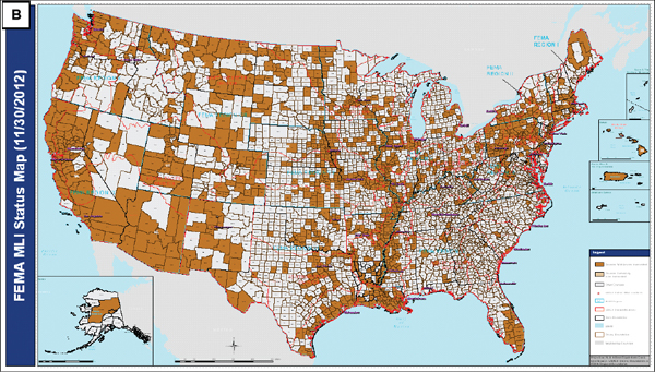
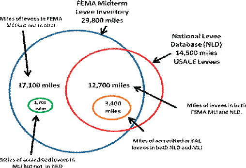
FIGURE 6-13 Overlap between USACE NLD inventory of USACE levees and levees identified in FEMA’s MLI. FEMA’s MLI includes 29,800 miles of levees, and USACE’s NLD identifies 14,500 miles of levees; 17,100 miles of levees in FEMA’s MLI are not included in USACE’s NLD, approximately 1,700 of which are accredited; 12,700 miles of levees in FEMA’s MLI are included in the USACE’s NLD, approximately 3,400 of which are accredited or PAL. This represents a 66 percent overlap. All values are approximate.
accreditation status of all currently known levees14 at the statewide level (Resilience Institute, 2010). Of the 697 miles of identified levees found within the state, 18 percent (approximately 125 miles) were found to currently be accredited, provisionally accredited, or de-accredited. Only 9 percent (approximately 62 miles) of all levee miles were found to be accredited. The long-term goal is that the Washington inventory will be strengthened to the point where it will be a useful tool in developing a prioritized list of levees needing site-specific attention (such as repair, certification and accreditation, and/or removal) and in the prioritization of state support for such levees (Resilience Institute, 2010).
ASFPM (Association of State Floodplain Managers). 2012. National Committee on Levee Safety (NCLS). Available online at http://www.floods.org/index.asp?menuID=338. Accessed August 7, 2012.
Boon, J. D., J. M. Brubaker, and D. R. Forrest. 2010. Chesapeake Bay Land Subsidence and Sea Level Change: An Evaluation of Past and Present Trends and Future Outlook. Available online at http://web.vims.edu/GreyLit/VIMS/sramsoe425.pdf?svr=www. Accessed February 21, 2013.
Briaud, J. L., H. C. Chen, A. V. Govindasamy, and R. Storesund. 2008. Levee erosion by overtopping in New Orleans during the Katrina hurricane. Journal of Geotechnical and Geoenvironmental Engineering 134(5): 618-632.
Brody, S. D., S. Zahran, P. Maghelal, H. Grover, and W. E. Highfield. 2007. The rising costs of floods: Examining the impact of planning and development decisions on property damage in Florida. Journal of the American Planning Association 73(5): 330-345.
_______________
14 The State of Washington defines a levee as a “fabricated barrier along rivers, streams, channels, sloughs, and other water courses” (Resilience Institute, 2010).
Brody, S. D., W. E. Highfield, and J. E. Kang. 2011. Rising Waters: Causes and Consequences of Flooding in the United States. Cambridge, UK: Cambridge University Press.
Burby, R. J., and L. C. Dalton. 1994. Plans can matter: The role of land use plans and state planning mandates in limiting the development of hazardous areas. Public Administration Review 54(3): 229-238.
CA DWR (California Department of Water Resources). 2010. Draft State Plan of Flood Control Descriptive Document. Available online at: http://www.water.ca.gov/cvfmp/docs/DRAFT_SPFC_Descriptive_Doc_20100115.pdf. Accessed July 31, 2012.
Crowell, M. 2010. Impact of Climate Change on the NFIP. Presentation to the Coastal Engineering Research Board Meeting, June 22. Vicksburg, MS: USACE. Available online at http://chl.erdc.usace.army.mil/dirs/events/319/08%2087th%20CERB%20Crowell.pdf. Accessed March 3, 2013.
CVFPP (Central Valley Flood Protection Plan). 2012. 2012 Central Valley Flood Protection Plan, a Path for Improving Public Safety, Environmental Stewardship, and Long-Term Economic Stability. Available online at http://www.cvfpb.ca.gov/CVFPP/index.cfm. Accessed January 28, 2013.
FEMA (Federal Emergency Management Agency). 1997. Building a disaster-resistant community: Project Impact. The Project Impact Guidebook. Washington, DC: FEMA.
FEMA. 2000. Above the Flood: Elevating Your Floodprone House. Available online at http://www.fema.gov/library/viewRecord.do?id=1424. Accessed November 28, 2012.
FEMA. 2006. The National Levee Challenge: Levees and the FEMA Flood Map Modernization Initiative. Washington, DC: FEMA.
FEMA. 2007. Selecting Appropriate Mitigation Measures for Floodprone Structures. FEMA 551. Available online at http://www.fema.gov/library/viewRecord.do?id=2737. Accessed January 22, 2013.
FEMA. 2010a. Hazard Mitigation Assistance Unified Guidance on the Hazard Mitigation Program, Pre-Disaster Mitigation Program, Flood Mitigation Assistance Program, Repetitive Flood Claims Program, and Severe Repetitive Loss Program. Available online at http://www.fema.gov/library/viewRecord.do?id=4225. Accessed January 29, 2013.
FEMA. 2010b. Mitigation Planning Fact Sheet on Risk MAP. Available online at http://www.fema.gov/library/viewRecord.do?id=2066. Accessed November 14, 2012.
FEMA. 2011. Midterm Levee Inventory Project Summary Report. Available online at: http://www.r3levees.org/wiki/images/0/03/MLI_Summary_Report_20111130_Final.pdf. Accessed August 8, 2012.
FEMA. 2012a. Analysis and Update of National Flood Hazard Layer Demographics and NFIP Policy and Claims Data. Prepared by Risk Assessment, Mapping, and Planning Partners, project report for task order #HSFEHQ-11-J-002. Washington, DC: FEMA.
FEMA. 2012b. Midterm Levee Inventory Project Summary Report: Standard Operations Task Order 4, November. Washington, DC: FEMA.
FEMA. n.d.a. Non-residential Floodproofing Requirements and Certification for Buildings Located in the Special Flood Hazard Areas in Accordance with the National Flood Insurance Program. Technical Bulletin 3-93. Available online at http://www.fema.gov/library/viewRecord.do?id=1716. Accessed February 15, 2013.
FEMA. n.d.b. The Unified Hazard Mitigation Assistance Grant Programs Factsheet. Available online at http://www.fema.gov/library/viewRecord.do?id=3648. Accessed January 29, 2013.
FEMA. 2013. Hurricane Sandy Advisory Base Flood Elevations (ABFEs) in New Jersey and New York. FEMA Region 2. Available online at http://www.region2coastal.com/sandy/abfe, accessed February 27, 2013.
FM Global. 2006. Approval Standard for Flood Abatement Equipment, Class Number 2510. Available online at http://www.fmglobal.com/assets/pdf/fmapprovals/2510.pdf. Accessed December 6, 2012.
FM Global. n.d. Understanding the Benefit, FM Approved Flood Abatement. Available online at http://www.fmglobal.com/assets/pdf/P11204.pdf. Accessed December 6, 2012.
FWS (U.S. Fish and Wildlife Service). 2002. The Coastal Barrier Resources Act: Harnessing the Power of Market Forces to Conserve America’s Coasts and Save Taxpayers Money. Available online at http://www.fws.gov/CBRA/Docs/Taxpayer-SavingsfromCBRA.pdf. Accessed November 28, 2012.
FWS. 2012. Background information on the Coastal Barrier Resource Act. Available online at http://www.fws.gov/CBRA/Act/index.html. Accessed November 28, 2012.
Galloway, G. 2009. Reacting to Climate Change, Floods, and Uncertainty. Available online at http://www.colorado.edu/hazards/. Accessed October 31, 2012.
Galloway, G. E, D. F. Boesch, and R. R. Twilley. 2009. Restoring and protecting coastal Louisiana. Issues in Science and Technology 25(2): 29-38.
GAO (Government Accountability Office). 2007. IRS Emergency Planning, Headquarters Plans Supported Response to 2006 Flooding, but Additional Guidance Could Improve All Hazard Preparedness. GAO-07-579. Washington, DC: GAO.
Hirsch R. M., and K. R. Ryberg. 2012. Has the magnitude of floods across the USA changed with global CO2 levels? Hydrological Sciences Journal 57(1): 1-9.
ILPRC (Interagency Levee Policy Review Committee). 2006. Sharing the Challenge: Floodplain Management into the 21st Century. Washington, DC: ILPRC.
IPCC (Intergovernmental Panel on Climate Change). 2012. Managing the Risks of Extreme Events and Disasters to Advance Climate Change Adaptation. A Special Report of Working Groups I and II, C. B. Field, V. Barros, T. F. Stocker, D. Qin, D. J. Dokken, K. L. Ebi, M. D. Mastrandrea, K. J. Mach, G.-K. Plattner, S. K. Allen, M. Tignor, and P. M. Midgley, eds. Cambridge, UK, and New York: Cambridge University Press.
Jones, C. P., W. L. Coulbourne, J. Marshall, and S. M. Rogers, Jr. 2006. Evaluation of the National Flood Insurance Program’s Building Standards. Washington, DC: American Institutes for Research.
Kousky, C., and L. Shabman. 2012. The Realities of Federal Disaster Aid: The Case of Floods. Issue Brief 12-02. Washington, DC: Resources for the Future.
Kunreuther, H. 1996. Mitigating disaster losses through insurance. Journal of Risk and Uncertainty 12: 171-187.
Lehmann, E. 2011. Flood-Prone Land Likely to Increase by 45%—A Major Challenge to Federal Insurance Program. Available online at http://www.nytimes.com/cwire/2011/07/22/22climatewire-flood-prone-land-likely-to-increase-by-45-a-19117.html?pagewanted=all. Accessed January 28, 2013.
National Capital Planning Commission. 2008. Report of Flooding and Stormwater in Washington, DC. Washington, DC: National Capital Planning Commission.
NCLS (National Committee on Levee Safety). 2009. Draft Report to Congress on Recommendations for a National Levee Safety Program. Available online at http://www.iwr.usace.army.mil/ncls/docs/NCLS-Recommendation-Report_012009_DRAFT.pdf. Accessed August 8, 2012.
NOAA (National Oceanographic and Atmospheric Administration). 2013. 2013 Draft National Climate Assessment Report. Available online at http://ncadac.globalchange.gov/. Accessed January 15, 2013.
NPR (National Public Radio). 2012. Norfolk, Va., Puts Flooding Survival Plan to the Test. November 6, 2012. Available online at: http://www.npr.org/2012/11/06/164362276/norfolk-va-puts-flooding-survival-plan-to-the-test. Accessed November 28, 2012.
NRC (National Research Council). 2010. Adapting to the Impacts of Climate Change. Washington, DC: The National Academies Press.
NRC. 2011. Building Community Disaster Resilience Through Private-Public Collaboration. Washington, DC: The National Academies Press.
NRC. 2012a. Dam and Levee Safety and Community Resilience. Washington, DC: The National Academies Press.
NRC. 2012b. Disaster Resilience: A National Imperative. Washington, DC: The National Academies Press.
Opperman, J. J., G. E. Galloway, J. Fargione, J. F. Mount, B. D. Richter, and S. Secchi. 2009. Sustainable Floodplains Through Large-Scale Reconnection to Rivers. Science 326: 1487-1488.
Raff, D. 2013. The 21st Century River: Changing Hydrology. Presentation to the Lower Mississippi Vision Summit, New Orleans, LA, January 9. Washington, DC: Meridian Institute.
Resilience Institute. 2010. Washington State Statewide Levee Inventory and Flood Protection Study: Report on Certification and Accreditation. Bellingham, WA: Western Washington University.
Rogers, J. D. 2009. We Have to Employ Systems Engineering Concepts in the 21st Century. Presentation at Flood Protection and Ecosystem Restoration Flood Conference, Louisiana State University, January 23. Available online at http://www.laseagrant.org/floodprotection/ppts/3b-Rogers4.pdf. Accessed November 15, 2012.
Sayers, P., G. Galloway, E. Penning-Rowsell, F. Shen, K. Wang, Y. Chen, and T. Le Quesne. In press. Flood Risk Management: A Strategic Approach—Consultation Draft. UNESCO on behalf of World Wildlife Fund—UK/China and the General Institute of Water Design and Planning, China.
Schropp, M. H. E., and T. W. Soong. 2006. Scientific Developments ISFD3. Pp 247-250 in Floods, From Defence to Management, J. van Alphen, E. Van Beek, and M. Taal, eds. London, UK: Taylor and Francis Group.
Storesund, R., R. G. Bea, M. Bernhardt, J.-L. Briaud, D. Franken, A. Govindasamy, S. Gyu, D. Kim, M. Leclair, G. Hempen, N. R. Maerz, J. D. Rogers, and C. M. Watkins. 2009. 2008 Midwest Levee Performance Investigation: Summary of Field Reconnaissance. Arlington, VA: National Science Foundation.
USACE (U.S. Army Corps of Engineers). 1986. Overtopping of Flood Control Levees and Floodwalls. Technical Letter No. 1110-2-299. Washington, DC: USACE.
USACE. 2006. Risk Analysis for Flood Damage Reduction Studies. ER 1105-2-101. Washington, DC: USACE.
USACE. 2012a. Inspection of Completed Works [Levee Safety Program] Factsheet as of February 2012. Baltimore District. Available online at http://www.nab.usace.army.mil/Factsheets/PDFs/Operations/MD-NY-PA-VA-WV-LeveeSafetyProgram-OM&.pdf. Accessed January 25, 2013.
USACE. 2012b. Northwest Division. Missouri River Flood Task Force (MRFTF). Available at http://www.nwd-mr.usace.army.mil/rcc/MRFTF/default.html. Accessed October 2012.
USACE. 2012c. What We Know About USACE Levees. Washington, DC: USACE.
USACE. n.d.a. National Nonstructural Flood Proofing Committee. Available online at http://www.usace.army.mil/Missions/CivilWorks/ProjectPlanning/nfpc.aspx. Accessed November 15, 2012.
USACE. n.d.b. USACE Disaster Operations Public Law 84-99. Available online at http://www.nfrmp.us/docs/PL84-99factsheet.pdf. Accessed February 18, 2013.
USGCRP (U.S. Global Change Research Program). 2009. Global Climate Chance Impacts in the United States. Regional Climate Impacts, Northeast. Available online at http://nca2009.globalchange.gov/. Accessed February 19, 2013.
WRC (Water Resources Council). 1973. Water and Land Related Resources: Establishment of Principles and Standards for Planning. Washington, DC: WRC.
WRC. 1983. Economic and Environmental Principles and Guidelines for Water and Related Land Resources Implementation Studies. Washington, DC: WRC.
WRDA (Water Resources Development Act). 2007. Public Law 110-114. Available online at http://www.evergladesplan.org/wrda2000/wrda_docs/wrda_2007.pdf. Accessed February 27, 2013.
Xu, Y., L. Li, and F. Amini. 2012. Slope stability analysis of earthen levee strengthened by high performance turf reinforcement mat under hurricane overtopping flow conditions. Geotechnical and Geological Engineering 30(4): 893-905.


