
12
Water Erosion and Damage to Coastal Structures
Hsaing Wang, University of Florida, Gainesville
INTRODUCTION
One facet that distinguishes Hugo from other hurricanes in recent years was the severity of water damage to coastal structures. In this context, Hugo could easily be ranked one of the worst storms to hit the U.S. mainland, comparable with Hurricane Camille in 1969, which made landfall along the lowland region of Louisiana and Mississippi at category 5 strength—the only storm to do so this century. Three key factors contributed to the extreme water damage caused by Hugo:
-
The extremely high storm-surge level, second only to that of Hurricane Camille;
-
The high density of old structures constructed before adequate building code and code enforcement; and
-
The high chronic background erosion along these barrier islands (approximately 6 ft per year) (Dolan et al., 1983).
Damage reconnaissance was carried out at selected locations from Seabrook Island to North Myrtle Beach, an arc of about 120 miles, the coastal belt hit hardest by Hugo. Based upon visual inspection, the severity of water damage was determined subjectively. Table 12-1 presents the percentage of destroyed beachfront structures along the barrier coast of South Carolina.
DAMAGE DESCRIPTIONS
Seabrook Island
The most heavily developed portion of Seabrook Island is a planned resort community of town houses and multiunit condominiums. The island is under erosional stress, and a portion of it is heavily armored with a new revetment. Both wind and water damage were light. Structural damage was limited to a few broken
TABLE 12-1 Percentage of Destroyed Beachfront Structures Along the Barrier Coast.*
windows, missing roof shingles, and damaged chimneys. The revetments showed differential settlement at a few locations with torn filters, thus exposing the bank soil.
Damage was light despite the exposed location. This was mainly because the island is located at the southern fringe of the hurricane path. The storm surge never reached the structures. Wave overtopping was also minimal.
Folly Beach
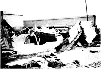
Folly Beach, on the barrier island (Folly Island) south of Charleston, is largely a residential community. The only substantial commercial building fronting the beach is the Holiday Inn at the middle section of the island. The beach is under very heavy erosional stress because of a lack of sand supply from the north. In fact, West Arctic Avenue crumbled into the sea within the last decade. A restaurant built 20 years ago on Arctic Avenue was hanging over water before Hurricane Hugo, and it was completely demolished by the storm (see Figure 11-4). Many houses on the west side of the town still officially have addresses on West Arctic Avenue, which no longer exists. The beach is narrow and low, with many groins and revetments of marginal quality.
The storm-surge measured near the midsection of the island averaged about 12 ft, but was slightly lower toward the east and south ends of the island. The east and central sections of the island sustained severe water damage. Many single-family homes fronting the beach were completely destroyed. First-floor flooding was common in the second tier and to a much lesser extent in the third row and beyond. Damage due both to dynamic force and static buoyancy was evident as some
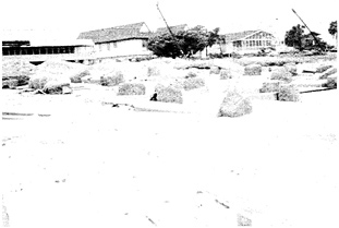
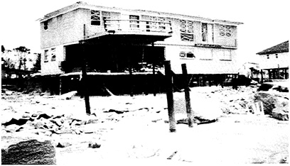
structures were crushed and the others were simply floated off their foundations. The most devastated section was between West 2nd Street and West 7th Street. This was because many structures built 20 years ago were clustered in this section. This section was also eroded heavily in past years and, as mentioned earlier, had lost roads to the ocean. However, amid this devastation, well-constructed dwellings survived well. The house shown in Figure 12-1, for instance, escaped with hardly any visible damage among a row of completely destroyed houses.
Figure 12-1 shows a frame structure with four concrete columns seated on four 14-inch-square piles. After discussions with the design architect and the county building inspector, the investigative team concluded that this structure fared well for five reasons:
-
sufficient elevation (bottom of support beam at elevation 15 ft MWL)
-
deep and strong piles (22-ft plus 5-ft tip)
-
simple and strong connections
-
low profile and low roofline
-
very rigid main columns.
Farther toward the west end of the island, the water damage became progressively lighter, but was still noticeable. The structures in this section (on West 7th Street) were generally newer, with higher elevations and better construction. The western tip of Folly Beach is the county park, where only wind damage was noticeable.
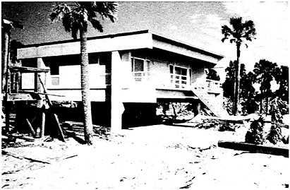
FIGURE 12-1 A concrete residential structure on Folly Island survived with in an area of heavy destruction.
The Holiday Inn is the only substantial commercial building along the open coast. It is a relatively new structure, built about 5 years ago. The building is at an exposed location with receding shorelines on both sides. The front is protected by a retaining wall and heavy revetment. The building, nevertheless, sustained heavy water damage. Practically all the ground-floor facilities were destroyed (Figure 12-2). Erosion behind the retaining wall was significant, causing the concrete deck to collapse and undermining the swimming pool. The seawall cap was partially destroyed by wave impact. The water damage was certainly heavier than one would expect for structures of this type built at such a recent date. The team identified three factors that contributed to the heavy damage:
-
The elevation of the structure and the protective seawall were inadequate for the surge level associated with Hugo.
-
There is no fronting beach to dissipate wave energy, causing heavy wave runup and overtopping.
-
The structure protrudes beyond the adjacent shoreline, and there is no return wall to protect its flanks.
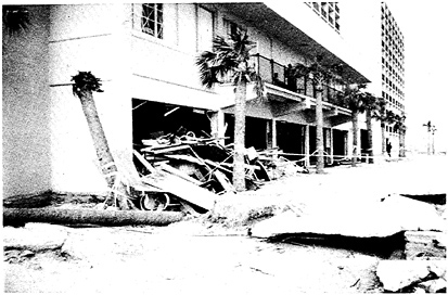
FIGURE 12-2 Water damage to the ground-level units and waterfront amenity facilities at the Holiday Inn on Folly Island. This damage was typical of that suffered by highrise hotels and condominiums.
Charleston and Vicinity
In the city of Charleston and its surrounding areas, including Mt. Pleasant and James Island, water damage to structures related to flooding was minor compared with wind-related damage (including rainwater damage due to broken windows and open roofs). The Battery, along the southern tip of Charleston, provided adequate protection of city streets and riverfront buildings. Hurricane Hugo was a relatively dry hurricane; heavy rainfall did not occur until 2 days later. Thus, river flooding was not a major factor. High water level in the creeks, the intracoastal waterway, and rivers, combined with high wind, did cause extensive damage to boats. Numerous boats were deposited on shore or in streets.
Sullivan's Island and Isle of Palms
Sullivan's Island and Isle of Palms are part of the same barrier island chain, separated by Breach Inlet. They have a combined length of about 11 mi, with the major axis oriented northeast-southwest. The only access to the mainland is Highway 703 via Ben Sawyer Memorial Bridge. This bridge has a rotating (swing) section in the center span for boat traffic. This section was so severely damaged by wind during Hurricane Hugo that the bridge was closed for more than 10 days.
On Sullivan's Island, the storm-surge level was estimated to be about 13 ft above MSL whereas on Isle of Palms the level was as high as 15 ft. The overall water damage was extensive on both islands, but the spatial distribution was uneven. Since the dominant wind direction at the height of the hurricane was northeasterly, the damage was less severe on the western end of Sullivan's Island. This section also benefitted from the wide beach. The sand overwash onto streets was substantial. The damage east of Highway 703 was extensive and became progressively worse toward Breach Inlet. Most older houses on Marshall Boulevard were destroyed; some were crushed by waves, while others were simply floated off their foundations. The majority of these older houses were mostly constructed on shallow piles, piers, or slabs, with elevations around 12 ft or less. After the hurricane, many of the damaged houses were raised to 14 ft or higher. A significant number of houses on the second row across the street were condemned because of water damage. The western end of Breach Inlet sustained erosion, but the bridge that spanned it was not threatened. All of the jetties on Sullivan's Island fared well.
Some of the newer constructions with adequate elevations and pilings did survive, even at very exposed locations east of 29th Street. The types of damage typical for new constructions are:
-
erosion and scouring, causing decks, pools, and slabs to collapse; and
-
collapse of deck structures with access ladders or ramps to the beach front, which causes secondary damage as loosened material slams into the main structure.
Severe damage on Isle of Palms was concentrated in two regions: the commercial strip between 10th Avenue and 14th Avenue, and between 42nd Avenue and 57th Avenue. The damage was less severe west of 9th Avenue and between 14th Avenue and 42nd Avenue. This appeared to be directly related to the beach width in front of the structures.
The Sea Cabin Condominiums at Ocean Boulevard and 14th Avenue sustained heavy water damage. The entire complex was prefabricated modular units seated on a pile foundation. The ground units and the end unit were severely damaged. Inadequate elevation and poor structural member connections were the main reasons for failure. Two exposed structures on Ocean Boulevard (nos. 126 and 912) stood with little visible damage from wind or water. (Figure 12-3 shows the post-storm condition of no. 912.)
Both structures were built by the same contractor, and the structures appeared to exceed the current building code requirement. Class “B” piles (120-inch-diameter from butt end and 14-inch-diameter above ground) with 3/4-inch steel diagonal bracings were used. Frames were connected throughout with 1/2- and 3/4-inch plywood using 16d galvanized nails at 4-inch intervals around corners to ensure shear rigidity. Hurricane clips were properly installed at critical connection points around roof frame and at pile-beam junctions. Roof tiles were properly nailed to 5/8-inch roof plywood. A ridge vent was installed to relieve pressure differences. As a consequence, only a minimal number of roof tiles were missing, uncharacteristic of the general extensive roof damages in this region. Members that are subject to wind-induced lift force were connected by galvanized screws instead of nails.
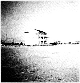
FIGURE 12-3 A well constructed, pile-supported, wooden frame residential structure on Isle of Palms fared very well, even in an exposed location.
Between 14th Avenue and 41st Avenue, there is no spur road south of Highway 703. Therefore, all the structures are set far back from the waterline, with exceptionally wide beach and dunes. Water damage to houses was minimal in this reach. Some washover on the highway was evident. East of 42nd Avenue, roads perpendicular to Highway 703 extend to the south close to the beach. Houses at the end, sometimes to the second and third rows, were damaged primarily by the combined effects of high surge level and proximity to the open water. Unlike some of the devastated areas mentioned earlier, most of the houses here are up-scale, newer structures. Damage was mainly due to dynamic forces rather than to flooding. This section provided a classic example of diminishing damage as a function of increasing distance from the shoreline. On 50th Avenue, there were five houses in a row. The first two were leveled to the ground; the third and fourth sustained progressively less damage, some from being hit by the debris of the destroyed houses. The fifth house, which was farthest from the shore, had no evident water damage.
At the eastern tip of Isle of Palms is the Wild Dune luxury condominium complex, the only highrise community on the island. Water damage was limited to washed-away walkways that were carried off, local scouring near foundations, and ground-level utilities. Since this area bore the frontal assault of Hugo's winds, tree, roof, window, and chimney damages were extensive.
McClellanville and Vicinity
McClellanville is a fishing community with predominantly modest wood frame houses. Mobile homes are also common in this region. The estimated landfall of the hurricane center was Bull Bay, just south of the town, and the highest storm surge was measured here, reaching 20 ft or more. Water damage was very extensive. Unlike the barrier islands, however, damage here was mainly due to flooding.
Northern Coast of South Carolina
The northern coast, known as the Grand Strand area, has developed rapidly in recent years. Nonconforming structures also flourished. Until the last 2 years, building code enforcement was rather lax and relied on individual communities. Now, Horry County, which has jurisdiction over most of the affected areas, has adopted the Standard Building Code and intends to strengthen inspection and enforcement.
Pawleys Island is a relatively old residential community. Houses are located very close to one another. Quality of construction was marginal at best. The storm-surge level was about 13 ft. The beach was very narrow during the posthurricane survey. As an emergency measure, sand was trucked from the south end of the island (near North Inlet) to repair the most eroded part of beach in the north. Water damage to buildings was very severe because of the combined factors stated above.
Garden City is also a residential community, with a few condominiums and a controlled-access planned community at the south end. The main thoroughfare, Waccamaw Avenue, is also the first street parallel to the beach. The road surface is about 8 to 11 ft above MSL. The measured storm surge was about 13 ft, but, local residents claimed the water level to be much higher (over 20 ft) along the coastal front. Salt spray was estimated to reach vertically 200 to 300 ft right after the passage of the hurricane. This observation, the first of this kind, was made by Mr. Carlos Fredes, who is a county building official and lives on the island. He made his estimate based on the mist level as observed against the backdrop of a transmitting tower that has a string of stroboscopic lights.
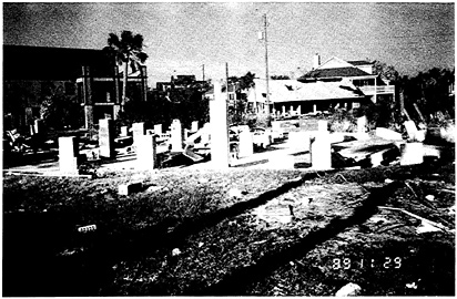
The water damage and sand washover were among the worst of all the areas inspected. Water damage due to flooding can be traced as far back as 1,500 ft, affecting as many as four or five rows of houses along the shore; the sand washover was measured to be higher than 1 ft at the second row of houses north of Waccamaw Avenue (see Figure 12-4). Immediately after the hurricane, debris was piled 20 ft high at intersections, which made passage to the second row impossible from either side.
On the north end of Garden City, south of Atlantic Avenue, destruction of the first row of houses was almost complete for four or five blocks. Many of the houses in the second row of this area were also completely destroyed. Two fishing piers, each 1,000 ft long, disappeared completely. Most of the structures—both commercial or residential—were constructed 10 years ago; a few are 20 or 30 years old or more. Most structures had only shallow pier footings, and others had slab foundations.
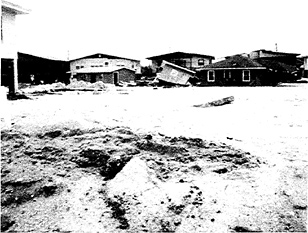
FIGURE 12-4 Sand overwash on second row of houses (north of Waccamaw Avenue), Garden City.
Judging from the crushing pattern and the type of pier breakage, waves might have overtopped the structures.
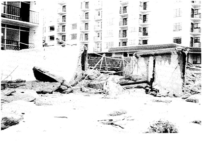
The water damages were very heavy south from this location to a place where Waccamaw Avenue took a dog-leg turn toward the north. In this reach, the structures were a mixture of old (20 years or more) and new (5 years or less). As in the north reach, the older structures were practically wiped out. The newer ones, particularly those built within the last 2 years, appeared to have largely survived despite varying degrees of minor damage. However, not all the new structures survived. One exception, a concrete two-story structure built 5 years ago by an architect collapsed completely (Figure 12-5). This structure had heavy reinforced concrete roof beams and precast concrete walls. But it was supported by cinderblock piers and bearing walls on a poured-concrete shallow footing. Waves must have hit the structure, causing the concrete front walls to collapse and the piers on the back to buckle. This concrete structure provided a drastic contrast to the concrete structure on Folly Beach discussed earlier.
The loss of beach and scouring around foundations were among the severest witnessed along the entire coast affected by Hugo. Beach loss of up to 6 ft of sand around structural piles was common. An additional 1 to 1 1/2 ft of scouring was measured around some large piles.
Farther south on Waccamaw Avenue, water damage became considerably less severe. South of no. 336 (the junction of a dog-leg turn), only three houses were destroyed. The houses here are all relatively new. The beach is also wider than in the north because of the dog-leg turn inland.
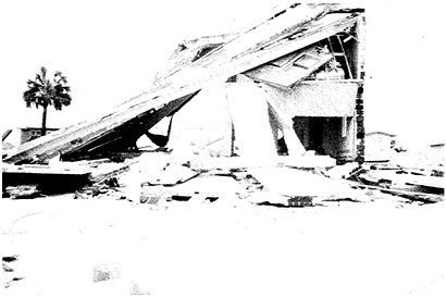
FIGURE 12-5 A two-story concrete residential structure collapsed under its own weight because of weak foundation (Garden City).
Surfside is connected to Garden City on the north. Unlike Garden City, there are predominantly commercial structures along the beach, mainly condominiums and highrises. Some of the older commercial buildings just north of Atlantic Avenue sustained considerable damage. The first floor of the Ocean View Motel was a total loss. Water damage became less severe farther north, although a few condominiums sustained considerable wind damage. The nature of the water damage was quite different than that which occurred in other regions. Septic tanks, drain fields, and sewer lines were the most common components experiencing damage because of erosion. Swimming pools, spas, decks, and other waterfront auxiliary structures protected by seawalls and/or revetments also suffered heavy damage from undermining. Seawalls, new or old, were found to be of insufficient elevation. Most of the return walls were too short and structurally inadequate.
Myrtle Beach and North Myrtle Beach were on the northern fringe of the hurricane influence. Surge level was established to be about 13 ft. However, water damage, however, was much lighter compared with that at Garden City or Surfside. Exposed septic tanks and sewer lines were visible at a number of locations, particularly between buildings, where the sand losses were more severe than in the front of the structures. Unlike Surfside, many waterfront swimming pools and spas survived structurally, although the quality of protective seawall structures was found to be similarly poor. This difference might be partially attributed to the recent beach nourishment along Myrtle Beach.
PERFORMANCE ASSESSMENT
Based upon damage surveys, the factors that critically affect the structural performance against water loads are discussed here.
Foundations
In assessing water damage to coastal structures, the main focal point is the foundation, and how the superstructure is connected. A great variety of foundations was found along this coast. Generally, they fall into one of three categories: slab-on-grade or poured footings, piers of various material and construction, and piles.
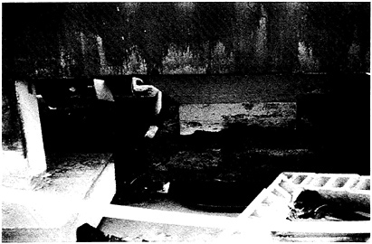
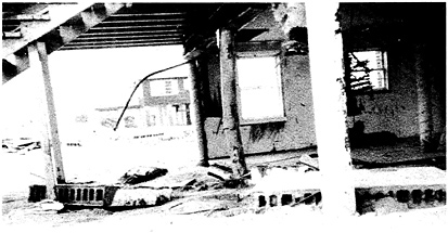
Slab-on-grade and poured footings were repeatedly found to be unfit for coastal application. This type of foundation is particularly vulnerable to hurricanes such as Hugo that generate high storm surges. Structures on such foundations have very little chance to escape severe damage if the water level is higher than the foundation. Two common modes of structural failure were observed: total destruction by dynamic forces (Figure 12-6) or separation and transportation by flood waters (Figure 12-7a and Figure 12-7b).
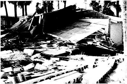
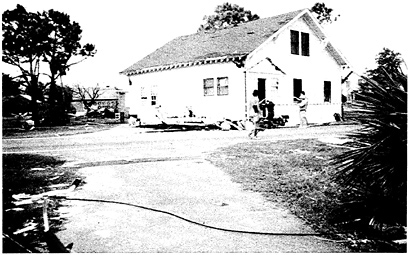
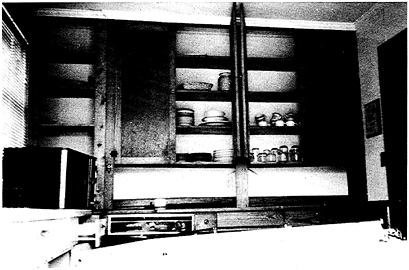
FIGURE 12-7b The arrangement inside the kitchen of the same structure remained undisturbed.
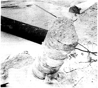
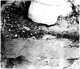
FEMA's guidelines and most building codes permit pier foundations for residential buildings. The Hugo experience showed that this type of foundation is very vulnerable in the dynamic water force zone. The inherent problem of this type of foundation is the shallowness of the footings that are typically dug and poured in place. As the overburden material began to erode, the footings simply toppled, as shown in Figure 12-8. Bulky shallow footings fared the worst, as they often promoted local scouring of up to 1 to 1.5 ft (Figure 12-9).
Above ground, masonry piers are inferior to wood or poured concrete piers. Masonry piers often failed because of inadequate reinforcement, poor workmanship on masonry fills, and weak joints between blocks (Figure 12-10). Poured concrete piers often failed because of inadequate or improper placement of reinforcing bars (Figure 12-11). The joint between the pier and the footing was also a common place of failure (Figure 12-12). Poor construction practice was prevalent among older structures.
Pile foundation is becoming the standard in modern construction. Properly sized and installed piles invariably performed well. It should be the only type of foundation allowed in the dynamic zone. Failures were mainly due to rot. Failures attributed to inadequate penetration and pile size were also found on a few occasions. Both concrete and wooden piles were found to be effective. Concrete piles usually showed good rigidity and required simpler connections. Corrosion of rebars and their subsequent expansion was the main cause of pile weakening and led to eventual failures. For piles of inadequate sizes, brittle failure was also evident. Wooden piles require more lateral bracings and closer attention to connections, as they are more flexible. Steel rod bracing appeared to perform better than wood board bracing.
Wood-board bracings were susceptible to breakage or buckling by wave forces, and tended to separate or rotate from the main members. The latter was because many of them were secured by nails rather than nuts and bolts, which are commonly used in metal bracings. Round wooden piles appeared to perform better than square piles, which are often considered more aesthetically pleasing. The hardened outer layer of square piles were often partially sawed off, exposing the younger, softer inner fibers.
Elevation
Elevation undoubtedly was a dominant factor. Practically all residential structures sustained major damage, if not complete destruction, if the elevation was inadequate. Several modes of failure were observed. Structures collapsed under wave force; structures floated away from foundations; water went through the structures and washed away everything; and building interiors were damaged by flooding.
Setback
There was a definite correlation between the extent of water damage and the setback of the structure. Wider beaches clearly provided better protection by dissipating wave energy and retarding erosion when the storm-surge level was not excessive. When the storm-surge level significantly exceeded the dune crest, such beneficial effects appeared to diminish rapidly; that is, under high storm surge, wider beaches tend to create a false sense of security.
Appurtenant Structures
A surprising amount of damage was caused by failures of appurtenant structures. Decks with access ladders or ramps to the beach were extremely vulnerable. They were not designed to resist water forces, yet most of them were secured to the main structures. Water forces would most certainly destroy them, puncturing or tearing apart that portion of the main structure connected to them (Figure 12-13). Structural accessories such as ground floor garage doors, air conditioners, water tanks, and nonbreakaway walls contributed to additional damage to the main structures. Revetment armor units sometimes behaved like missiles powered by waves, as discussed earlier.
Structural Member Connections
Adequate connection of structural members plays a greater role in preventing wind, as opposed to water, damage. However, there were many cases in which
improper connections between floor beams and foundations allowed structures to float away, collapse, lean, or shift. Figure 12-14 shows an example of a modular unit completely separated from the foundation piles. Improper nailing practice or inadequate nail size were the prevailing cause of member separations under minor shift (Figure 12-15). Missing or inadequate hurricane clips was also problem. Mobile home tiedowns were found to be common. Very few mobile home units were found near the coast. One small mobile home park south of Myrtle Beach did suffer heavy damage, but this was mainly because of low elevation, rather than inadequate tiedowns.
Coastal Structures
Seawalls
Seawalls are numerous in the affected region. Most of them can be more accurately characterized as landscaping retaining walls, and did little to protect upland structures from water damage. Scouring behind seawalls due to overtopping was the most common damage observed, and led to failures of decks and pools or collapsed the seawalls themselves (Figure 12-16). In addition, most of the return walls were underdesigned, resulting in numerous failures (Figure 12-17). Once the
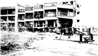
FIGURE 12-14a Modular unit construction with poor connections.
return walls failed, water quickly rushed in from behind as in a breached dam, causing rapid losses of material.
Revetments, Groins, and Jetties
Like seawalls, revetments are common in the affected area. They are particularly common on Folly Beach, Sullivan's Island, and Pawleys Island. Most of them are not engineered works. Instead, they are constructed by local contractors or even the individual property owners. The quality is evidently poor, with insufficient height and inadequate armor size. Some were a single layer on bare soil. Those structures should not be expected to serve their intended function, and they certainly did not. The armor units on the revetment slope, owing to insufficient height, often became missiles, hitting structures from behind, thus causing more harm than good. Some did perform marginally in retarding erosion behind the structure.
Along Folly Beach, Sullivan's Island, Isle of Palms, Pawleys Island, and Garden City, groins are interspersed, with a few areas of high density. Damage to them was surprisingly light, possibly because the high surge level simply submerged them. Jetties at a number of inlet entrances also appeared to fare well, possibly for the same reason.
Piers
Practically all the piers along this coast sustained severe damage or were totally destroyed. The few surviving had their midsections across the surf zone destroyed (Figure 12-18), which seemed to indicate where the most destructive water force had occurred. However, the extent of damage to these piers may make salvage efforts uneconomical.
CONCLUSIONS
Hurricane Hugo inflicted very severe water damage on structures near the coast. The consensus was that in the zones subject to water forces, the overall water damage far exceeded that caused by wind. However, under such circumstances, attempts to separate wind and water damage were often superfluous. This was quite different from some of the recent hurricanes, such as Alicia and Diana, where wind was clearly the dominant destructive force.
Damage assessment relied on visual inspection and personal interviews. The important findings are summarized below:
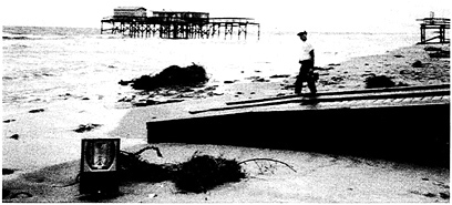
FIGURE 12-18 Piers with midsection missing revealed the location of maximum dynamic force to be in surf zone.
-
Water damage was extensive, but damage spatial distribution was very uneven.
-
Most of the well-engineered and well-constructed structures survived, some with very little damage. Both concrete and wood structures demonstrated their survivability. Wood structures usually require much more attention to detail; that is, there were are components and joints that could fail than for concrete structures.
-
Wide beaches and high dunes contribute significantly to abating storm surges. However, extremely high surges will overcome any beach or dune obstruction. In these circumstances, it is unclear whether wide beaches provide any additional protection.
-
Adequate elevation is a prerequisite for the structure to escape severe water damage.
-
Of the variety of foundation types, only deep piles of sufficient size (over 9 inches in diameter) performed consistently well.
-
Appurtenant structures were a significant factor contributing to damage.
-
Most of the “protective” structures were ineffective, owing to lack of proper engineering.
-
Structures, buildings, and protective structures appeared to retard local beach erosion.
RECOMMENDATIONS
Structures built on the open coast should be designed to avoid water force rather than resist it. Deep pile foundations are the only structural element that should be used, within reasonable cost, to resist hurricane-induced water forces. Other structural elements, if exposed in this water force zone, should be designed to break away under loading. Structural setback is important for a number of reasons: it reduces the cost of construction, it reduces the vulnerability of being exposed to dynamic water forces, and it reduces damage. Clearly, closer to the water line, higher structures and deeper and stronger foundations are required. Both the water crest line and the scouring line should be respected in coastal construction.
Further research should be conducted to simplify structural member connections. In the meantime, connections should be designed and constructed that exceed the Standard Design Code to minimize repair cost.
Protective structures should be engineered by personnel with special expertise. These structures, owing to their important function, should be regulated much the same as buildings in terms of engineering, code enforcement, and inspections. The large number of inadequate structures along the Carolina coast was the consequence of prolonged unregulated construction activities. Poorly designed, nonengineered structures create a false sense of security among owners of upland property, and could cause damage to surrounding structures. Furthermore, those “homemade” protective structures serve only to reinforce the public's perception that coastal structures are uniformly harmful. As a consequence, it is becoming increasingly difficult to gain public approval for coastal structures with legitimate purposes.
Finally, it must be emphasized that, in the coastal zone, meeting the Standard Building Code does not guarantee that damage will be completely avoided. Certain acceptable risks and levels of damage should be expected. Major revision of building codes to meet a stricter standard is not warranted. The experience of Hurricane Hugo suggests that enforcement of modern building codes and better construction inspection could drastically reduce hurricane-induced damage in the future.
REFERENCES
Dolan, R., B. Haydan, and S. May. 1983. Erosion of the United States shoreline. Pp. 285-300 in Handbook of Coastal Processes and Erosion, P.D. Komar, ed. Boca Raton, Florida : CRC Press.
U.S. Department of Commerce. 1980. Tropical Cyclones of the North Atlantic Ocean, 1871-1980. Asheville, North Carolina: National Climatic Center.


