
3
Emergency Planning and Response in Puerto Rico
Benigno E. Aguirre, Texas A&M University, College Station
INTRODUCTION
This chapter presents a preliminary assessment of a set of processes that the reconnaissance team characterized as the organized disaster response to Hurricane Hugo in Puerto Rico. Recommendations are included in the hope that they will improve the disaster-response system on the island. The operation of the NWS/WSFO is described and the reasons for its success identified. The SLOSH model, which was effectively used to plan and execute evacuations, is described. The similarities between these two successful programs are noted. Finally, elements in the disaster-response system that did not work well—i.e., sheltering, long-term emergency housing, and lifeline protection—are analyzed.
OPERATIONS OF THE WEATHER SERVICE FORECAST OFFICE IN SAN JUAN
Local WSFO operations during Hurricane Hugo were successful (NOAA, 1989). Working in close cooperation with the NHC, the office alerted the population in time to take necessary precautions. Table 3-1 documents the timing and characteristics of the numerous products issued by the local office during the emergency. As shown in this figure, the hurricane warning began at 1515 AST on September 16. A hurricane watch had started several hours earlier, on September 15 at 2100 AST. This timing represents an approximate watch lead time of 63 hours and a warning lead time of 42 hours, well in excess of the average lead times for hurricane watches and warnings (Don Wernly, NOAA/NWS, personal communication; NOAA, 1989, p. 50). As a result of these WSFO efforts, the Civil Defense Office of the Commonwealth of Puerto Rico activated the island's Disaster Interagency Committee (DIC) on September 15. The DIC is composed of 26 agencies. The Civil Defense Office alerted people living near the coast of the need to evacuate. Moreover, the Puerto Rican Consumer Protection Agency, DACO, froze the prices of key consumer goods.
TABLE 3-1 Timing and Characteristics of Selected San Juan WSFO Weather Announcements During Hurricane Hugo, September 15-22, 1989
|
Date |
Product |
Location |
Direction of Movement |
Maximum Sustained Winds |
Expected Storm Surge |
Total Height of Sea |
Effects |
|
9 pm Sept. 15 (Friday) |
Hurricane watch |
14.8 N latitude 56.3 W longitude 700 mi SE, San Juan |
westward 15 mph |
150 mph |
6′-10′ |
8′-12′ |
Effects will begin in South Central Puerto Rico Sunday evening. Beach erosion likely, flooded coastal roads |
|
12 am Sept. 16 (Saturday) |
watch |
15.0 N latitude 56.9 W longitude 650 mi E SE, San Juan |
same |
same |
10′ |
Heavy rains and tropical storm force winds will begin by Sunday morning in eastern Puerto Rico. Severe flooding. |
|
|
6 am Sept. 16 |
watch |
15.3 N latitude 58.3 W longitude 550 mi E SE, San Juan |
same |
same |
same |
Hurricane will reach south coast, Puerto Rico, Sunday night. Effect will begin Sunday morning flooding |
|
|
9:15 am Sept. 16 |
watch |
15.4 N latitude 58.7 W longitude 530 mi E SE, San Juan |
same |
140 mph |
same |
Effects will begin by midday Sunday. Heavy rains possible, some flooding. |
|
|
12:15 pm Sept. 16 |
watch |
15.6 N latitude 59.0 W longitude 500 mi E SE, San Juan |
same |
same |
same |
Heavy rains and tropical storm winds will begin in eastern Puerto Rico Sunday midday. |
|
|
3:15 pm Sept. 16 |
watch |
15.8 N latitude 59.5 W longitude 420 mi E SE, San Juan |
westward 12 mph |
130 mph |
same |
same |
|
|
6:15 pm Sept. 16 |
Hurricane warning |
16 N latitude 60 W longitude 435 E SE, San Juan |
W NW 12 mph |
140 mph |
8′-10′ |
same |
|
|
9:15 pm Sept. 16 |
warning |
16.1 N latitude 60.4 W longitude 400 mi E SE, San Juan |
same |
140 mph |
same |
Hugo will reach the northeast coast of Puerto Rico early Monday morning. Heavy rains and tropical storm force winds will begin early Sunday morning. |
|
|
12:05 am Sept. 17 (Sunday) |
warning |
16.3 N latitude 61.1 W longitude 310 mi E SE, San Juan |
same |
same |
same |
Same and flooding, rains up to 10″ (5″-10″) |
|
3 am Sept. 17 |
warning |
16.4 N latitude 61.8 W longitude 310 mi E SE, San Juan |
same |
same |
same |
hurricane expected to arrive late Sunday, 5″-10″ rains to be expected: flash flood warning and coastal flood watch. |
|
|
6 am Sept. 17 |
warning, coastal flood watch, flash flood watch, Puerto Rico |
16.5 N latitude 62.2 W longitude 285 mi E SE, San Juan |
same |
same |
same |
same |
|
|
9 am Sept. 17 |
same |
16.6 N latitude 62.7 W longitude 260 mi E SE, San Juan |
same |
same |
same |
Rapidly deteriorating conditions in the evening. Heavy rains and thunderstorms to occur in late afternoon and evening. Exposed coastal areas will be flooded. 5″-10″ rain to be expected. |
|
|
12 pm Sept. 17 |
same |
16.8 N latitude 63.3 W longitude 210 mi E SE, San Juan |
westward 12 mph |
140 mph |
8″-10″ |
Storm surge will decimate the coastal section where it comes on shore. Severe coastal flood and5″-10″ of rains to be expected with very strong winds. |
|
|
3 pm Sept. 17 |
warning, coastal flood watch, heavy surf advisory, flash flood watch |
17 N latitude 63.6 longitude 190 mi E SE, San Juan |
same |
same |
same |
Expect a 50 mile wide path of damage, extensive to extreme to occur; expect 5″-10″ rains in storm path in high accumulations in mountains of Puerto Rico. |
|
|
6 pm Sept. 17 |
warning, coastal flood warning, heavy surf advisory, flash flood watch |
17.1 N latitude 64.1 W longitude 170 mi E SE, San Juan |
same |
same |
same |
Same and heading for southwest coast of Puerto Rico. Hurricane expected to hit a little center tonight. |
|
|
7 pm Sept. 17 |
same |
17.1 N latitude 64.1 W longitude 155 mi E SE, San Juan |
same |
same |
same |
Same and severe coastal flooding to be expected. |
|
|
9 pm Sept. 17 |
same |
17.2 N latitude 64.3 N longitude 140 mi E SE, San Juan |
westward, NW, 10 mph |
same |
same |
Same and heavy rains and thunderstorms to be expected by 10 pm. |
|
|
1:30 am Sept. 18 (Monday) |
warning, coastal flood warning, flash flood watch |
over St. Croix in U.S. Virgin Islands |
W NW 9 mph |
8′-10′ |
Will move into large island of Puerto Rico monday morning; intense rains probably over 10″ will affect Puerto Rico, Extremely dangerous weather conditions . . . possibility of a fatal high tide over eastern Puerto Rico will occur shortly after 11 am monday morning. |
||
|
3 am Sept. 18 |
warning, coastal flood warning, flash flood warning |
17.6 N latitude 64.7 W longitude |
W NW 9 mph |
same |
Same |
||
|
4:30 am Sept. 18 |
warning, coastal flood warning, flash flood warning E Puerto Rico |
N NW of St. Croix |
W NW 9 mph |
same |
Same and landfall in Puerto Rico should occur mid-morning; heavy rains now cover eastern Puerto Rico. In western Puerto Rico, mudslides will occur later today, especially in interior Puerto Rico where mudslides are common. |
||
|
6 am Sept. 18 |
same |
17.9 N latitude 45.1 W longitude |
W NW 8 mph |
75 mph |
10′ |
Same and subsided winds will suddenly regain hurricane strength from opposite direction. Torrential rain continues over eastern Puerto Rico with higher gusts in most locations. Once landfall occurs, it will slowly move across Puerto Rico with hurricane force sinds continuing to affect Puerto Rico until 2 am tuesday morning, severe damage will occur. |
|
|
7:30 am Sept. 18 |
warnign, coastal flood warning, flood warning |
over Vieques Islands |
W NW 8 mph |
75 mph and gusts up to 110 mph |
astronomical high tide 10′ |
Same and severe damage can be expected in these coastal areas of eastern Puerto Rico; torrential rains to be expected. Sea water already reported to be entering the coastal sections of eastern Puerto Tico municipalities combined with actions of huge pounding waves. |
|
|
9 am Sept. 18 |
warning, coastal flood warning, flood warning, flash flood warning, central & western Puerto Rico |
eastern puerto Rico near Celba |
same |
Same and up to 15″ rains predicted. |
|||
|
10:30 am Sept. 18 |
same |
N of Rio Grande |
100 mph |
Same and extremely dangerous effects of the eyewall are pounding the northeast coast, indlucing the San Juan metro area. Since Hugo is west-northwest direction an eye tends to wobble in motion, destruction continues to skirt along most northern municipalities of Puerto Rico. |
|||
|
12 pm Sept. 18 |
same |
offshore 20 mi N, San Juan |
W NW |
41 mph gusts to 79 mph |
Same and winds shifting around to SW over Virgin Islands and eastern Puerto Rico as hurricane slowly pulls away to the west-northwest. |
||
|
1:30 pm Sept. 18 |
same |
44 mi to N of Vega Baja, Puerto Rico |
W NW |
decrease in sustained wind speed over northern Puerto Rico |
Moderate rainfall; still moving in a general westnorthwest direction, and if continues, threat of damaging winds to the municipalities in northern Puerto Rico is considerably lessened. Storm force winds will continue tonight. |
||
|
4:30 pm Sept. 18 |
hurricane warning, coastal flood warning, flash flood warning |
19.2 N latitude 66 W longitude 60 mi N NW of San Juan |
Decrease in major threat to local area with some lingering gale force winds and continuous light to moderate rain will prevail through early evening hours over Puerto Rico. It will take about 48 hours before weather conditions begin to return to their normality. |
||||
|
6 pm Sept. 18 |
same |
19.5 N latitude 67 W longitude 90 min N NW, San Juan |
NW 13 mph |
Same and light to moderate rain will prevail through midnight over Puerto Rico. Hugo has resumed a more NW track near 13 mph, motion is expected to continue into tuesday. |
|||
|
9 pm Sept. 18 |
NW, San Juan, moving away from Puerto Rico coastal flood warning, flash flood warning |
19.8 N latitude 67.1 W longitude 110 min NW, San Juan |
NW 12 mph |
115 mph |
Hurricane will resume a more northwest track near 12 mph motion that is expected to continue into tuesday. Hurricane warnings have been discontinued for Puerto Rico and surrounding areas. |
||
The dissemination of WSFO's weather information by the mass media in Puerto Rico was extremely effective. All of the major news dailies in San Juan published in their September 16 and 17 editions information about the location of the storm, the beginning of high winds by the afternoon of September 17, the probability of landfall on the morning of September 18, and the suggested preparations before and after impact (e.g., El Vocero, September 15, 1989, p. 8; and El Mundo, September 16, 1989, p. 6). According to the San Juan MIC, the use of visual satellite images by newspapers and television stations increased the credibility of the potential hazard in the eyes of the public. Broadcasters from two radio stations stayed at the WSFO throughout the event, broadcasting live every half hour and at more frequent intervals as new information became available. Their broadcasts were very helpful. For example, they calmed the fears of the residents of Skytower when the building began to rock because of the high winds (El Nuevo Dia, September 21, 1989, p. 55). Reportedly, there were more than 200 live broadcasts and interviews at WSFO. WKAQ, a powerful radio station received throughout the island, is the station that originated the EBS in Puerto Rico. The EBS was activated 10 times during the emergency period. The transmissions were broadcast in Spanish and English and were used by the governor on September 17 to warn people about the storm. These transmissions were also used by the Civil Defense Director of the Commonwealth of Puerto Rico and by WSFO personnel to alert the public (NOAA, 1989, pp. 25, 75).
Television stations in the San Juan metropolitan area also participated in the dissemination of the severe weather information. On September 17, the main television stations—Channels 2, 4, and 11—along with some radio stations, conducted live broadcasts from the WSFO San Juan office until around 1900 AST, as well as top-of-the-hour special reports. Station WKAQ-TV (Channel 2) transmitted directly from the headquarters of WSFO at San Juan's Luis Munoz Marin International Airport throughout the period of the emergency until 1900 AST on September 17. Other local TV stations—Channels 4, 11, and 24—also did top-of-the-hour special reports on Hurricane Hugo.
Reasons for WSFO Success/Effectiveness
Besides the technical proficiency of the staff, there are other important reasons for the success of the local WSFO. The station made the dissemination of weather products, not just their generation, a central part of its operation. For example, the office has a telephone line dedicated for the exclusive use of mass media personnel on the island, and it has an effective and talented media focal point staff (El Mundo, October 1, 1989, p. 22; and El Nuevo Dia, September 24, 1989, p. 9). San Juan WSFO conducted extensive public preparedness work with the mass media, including scores of visits, letters to radio and television station managers, participation in conferences, workshops for the media, and group meetings (see Table 3-1). Indeed, according to the MIC, they had been quite active from May through July, conducting hundreds of warning coordination and hazard preparedness programs, a hurricane
drill for the commonwealth in May, and three conferences for radio broadcasters and the EBS.
The WSFO personnel are friendly and accessible, and most are bilingual. The reconnaissance team was told by a newspaper editor how much he appreciated the fact that when he called the WSFO during the emergency, the native-English-speaking WSFO staff member who answered his call spoke with him in Spanish. Even though the officer was not a native speaker, it demonstrated to the editor the desire to serve the Puerto Rican public. This service- and consumer-oriented attitude pervades the operation of the WSFO in San Juan and is one of the most important reasons for its effectiveness during the crisis.
The WSFO is also effectively linked to other disaster-related agencies in the San Juan area. For example, it worked closely with the civil defense offices of the commonwealth and the San Juan metropolitan area in determining the evacuation times and local areas at risk of high winds and flooding. The WSFO and these two civil defense offices (in addition to at least two other municipalities adjacent to San Juan that the reconnaissance team visited) used the SLOSH “decision-arc” methodology developed by Techniques Development Lab for the U.S. Army Corps of Engineers (NOAA/NWS) to provide general evacuation times for threatened populations. They used the SLOSH model to plan the evacuation of municipalities threatened by the storm. The openness of the WSFO was appreciated by the civil defense directors. In the view of the civil defense authorities, NWS's openness contributed to their successful evacuations (e.g., El Mundo, November 7, 1989, p. 10). The SLOSH model provided a common tool that linked the WSFO and the municipal civil defense officials, one that had been found wanting in the aftermath of the October 1985 landslide on the island (Federal Emergency Management Agency, 1985, p. 9).
According to the MIC of San Juan, once the evacuation started on the morning of September 17, coordination calls with commonwealth civil defense occurred every 90 minutes. A month earlier, Puerto Rico had gone through a hurricane warning for Hurricane Dean, which had given this network of agencies and the people of Puerto Rico an opportunity to prepare for such an emergency. Fortunately, Hurricane Hugo occurred during a weekend, freeing people from their ordinary workweek responsibilities to prepare for the storm better. Approximately 30,000 people evacuated to safe areas (NOAA, 1989, p. 25).
U.S. ARMY CORPS OF ENGINEERS DECISION-ARC METHODOLOGY
This service was developed to facilitate evacuation, thus ameliorating the coastal impacts of hurricanes affecting the San Juan metropolitan area, from the town of Dorado in the west Rio Grande in the east (see Table 3-1). The area includes the municipalities of Loiza, Carolina, San Juan, Guaynabo, Catano, Toa Baja, and Dorado. The model excludes the effects of rainfall/runoff and riverine flooding brought about by hurricanes.
The SLOSH model takes into consideration the tracks of hurricanes that impacted San Juan in the past and the possible effects of category 2 through category 5 storms. It provides decision-arcs that use the distances of municipalities from eastward islands, such as Guadeloupe, to locate hurricanes and to indicate the “must start evacuation” and “must finish evacuation” zones for clearance times of 4 to 12 hours. The model provides localized time estimates for evacuations appropriate for a range of hurricane speeds, locations, and other relevant characteristics. It includes a written statement in Spanish, detailing the vulnerabilities of specific municipal areas to maximum still-water elevation, sea surge, wave set-up and run-up, and risk of high winds. It also includes preliminary assessments of the appropriateness of local shelters and transportation routes for use during various natural disasters.
Perhaps one of the best contributions of the SLOSH model during Hurricane Hugo was the advanced preparation and increased awareness and understanding of risk gained by the municipal authorities. Clearly, this work by the Corps of Engineers was successful and, as recommended by NOAA, it should be extended to the other 78 municipalities on the island. Currently, there is no comprehensive study of flooding and appropriate evacuation measures for Puerto Rico. The SLOSH product and the service provided by the local WSFO are two positive lessons emerging from the study team's analysis of Hurricane Hugo on Puerto Rico.
The SLOSH product was of significant help to the commonwealth and municipal civil defense directors contacted during the team's field visit. Analysis of the evacuation decisions of civil defense directors showed that they were aware of the details of the recommendations made by the Corps of Engineers; therefore, they began evacuating and sheltering people while taking into account the local lead time estimates recommended in the plan. The decision to evacuate was made by the Commonwealth Civil Defense Office and communicated to the civil defense offices of the municipalities at risk.
EVACUATIONS
The evacuation began at daybreak on September 17 and was completed 8 hours later. In the municipality of Catano, and in the San Juan area from Loiza west to Dorado, most of the evacuation had been completed early in the day on September 17. In San Juan, civil defense officials encountered initial resistance from the residents in the coastal area of Las Perlas, near El Morro Castle, and from close to 1,000 members of a religious sect called Los Mitas. These people eventually evacuated during the afternoon and evening of September 17 as the weather conditions deteriorated. In Catano, a municipality chronically exposed to a high risk of flooding, the local hospital had to be evacuated because of its proximity to the coast. Subsequently, this hospital was severely damaged by the storm.
The evacuation proceeded as planned, using the SLOSH model. Thus, the Municipio de Toa Baja evacuated the Palo Seco community and the Municipio de Catano evacuated the Puerto Catano community. Partial evacuations of the coastal
communities between Loiza Aldea and Rio Grande, and of La Torre and Pinones, also took place.
Detailed analysis of the preventive evacuation that took place along the coastline in the San Juan metropolitan area indicates that the Office of Civil Defense evacuated about 300 persons from Las Perlas. Close to 30 were evacuated from the Ocean Park area to the Parroquia de Santa Teresita. Further to the east, close to 100 persons were evacuated from the Puntas Las Marias area. Inland evacuations also took place, mainly near rivers, creeks, sewers, and lagoons. Thus, 70 persons were evacuated from the shores of Rio Puerto Nuevo to the Francisco Hernandez School, and to the south, 150 persons were evacuated from the Canal Margarita area to the Escuela E. M. de Hostos. About 175 residents of Sorbona Street, in the University Garden District, were also evacuated. To the east, close to 450 persons were evacuated from the west shore of Laguna Los Corozos, and 300 from the west shore of Laguna San Jose, in the San Jose area. About 150 persons were also evacuated from Los Penas because of fear of high winds.
In the municipality of Catano, the majority of the evacuations performed by civil defense occurred on the western shores of Bahia de San Juan, in an area from Bay View to Puerto Catano. Inland, the lower part of the town of Catano was also evacuated because of earlier experiences with the limited drainage in the area. Also evacuated were people living in houses near the Cano de San Fernando and in the Barriada Juana Matos. To the southwest of this area, the more significant evacuations occurred on the western side of Tuberias and in the Cucharillas area.
In the municipality of Carolina, parts of urban areas to the west (Jardin Country Club, Sabana Gardens, Valle Arriba Heights, and Villa Fontana) and east (villas Carolina, Esperanza I and II, Caridad, and Justicia) of Canal Blasina were evacuated. Other evacuations took place to the south of Canal Blasina, in Carolina Housing, Roberto Clemente, Loma Alta, and El Coral. The study team did not have sufficient time to document the evacuation activities, if any, of civil defense on the extensive coastline of Carolina.
FATALITIES AND HOMELESSNESS
According to the National Center for Disease Control, only two persons drowned during the storm. Seven persons died of other causes after the storm had passed. Most were public utility Autoridad de Energia Electrica (AEE), workers electrocuted by improperly connected electric generators (El Vocero, October 16, 1989, p. 5; and San Juan Star, November 10, 1989, p. 9). This low number of fatalities occurred even as tens of thousands of people lost their homes, especially in the municipalities of Vieques, Culebra, Ceiba, Fajardo, Naguabo, Humacao, Yabucoa, Loiza, Luquillo, Rio Grande, Canovanas, Carolina, and San Juan. Mass media reports (e.g., El Mundo, September 21, 1989, p. 3; and El Nuevo Dia, September 21, 1989, p. 6) calculated that 80 percent of the residents of Culebra and 1,000 families
in Vieques lost their homes, and that in the aftermath of the destruction more than 25,000 people were in shelters.
DAMAGE AND ECONOMIC EFFECTS
Hurricane Hugo caused widespread destruction to lifelines in Puerto Rico and had a significant adverse effect on the economy of the commonwealth. Thirty-five municipalities were left without electric power, and the San Juan metropolitan area suffered from lack of water for 9 days. The president of Puerto Rico Management and Economic Consultants, Inc., in general agreement with independent estimates provided by commonwealth officials, established the total losses to households, industrial plants, commercial and service establishments, and the government infrastructure at $2 billion (reported in San Juan Star, October 29, 1989, p. B-5; Table 3-2).
COMPARISON OF WSFO AND SLOSH METHODOLOGIES
There are significant similarities between the WSFO and SLOSH success stories. The two programs delivered a circumscribed product. The WSFO produced information about severe weather. The SLOSH project produced evacuation plans for the municipalities, as well as risk probabilities associated with threatening events, such as high winds, sea surge, and severe flooding. The two programs are part of federal bureaucracies staffed by career professionals who are embedded in Puerto Rican society because of either their own ethnicity or their willingness to include Puerto Rican officials in their program development and implementation. The two programs took into consideration the needs of Puerto Rican officials. Both made their services available in Spanish. The WSFO informed local officials about weather products and kept them apprised of unfolding events to assist with evacuation decisions. The U.S. Army Corps of Engineers developed their output with the active participation and assistance of Puerto Rican engineers and civil defense personnel, taking into consideration the local history and needs.
Both programs were able to serve local officials and the Puerto Rican people directly, without having to depend on complex intermediary local systems. In both cases, the native social organization existing between the producer and the consumer was rudimentary. In the first case, the intermediary was the mass media and the relevant civil defense managers. In the case of SLOSH, the intermediaries were WSFO and commonwealth and municipal civil defense officials. The intermediaries cooperated in each case, knew what to expect, and knew what needed to be done to make the operation a success. They were not forced to adopt extensive new technologies or changes in their social organization.
The services provided by WSFO and SLOSH did not allow profit at the margin. They could not be used for private gain other than normal career advances
TABLE 3-2 Puerto Rico's Balance Sheet: Hugo Losses (in millions of dollars)
|
Private Sector Losses |
|
|
Plants and equipment |
150 |
|
Business sector capital stock |
320 |
|
Agricultural sector |
100 |
|
Public Sector |
|
|
Airport, port, highways, roads |
100 |
|
Electric Power Authority |
50 |
|
Aqueduct & Sewer Authority, others |
200 |
|
Losses to Flora and Fauna |
150 |
|
Household Losses |
|
|
(200,000 households, averaging $1,000 each) |
200 |
|
TOTAL LOSSES |
2,000 |
|
Source: San Juan Star, October 29, 1989, p. B-5. |
|
associated with effective performance of official responsibilities. Also, the change in Puerto Rican society was limited to the operational arrangements of agencies, compared with the amount of change required by other disaster-related programs and services, such as coastal management and flood and earthquake risk prevention.
Quarantelli (personal communication, May 6, 1991) argues, with considerable merit, that the failure to carry out disaster mitigation and preparedness programs is primarily derived from the conservative nature of social systems; it is difficult to bring about change in any social system, especially preparing for low-frequency occasions such as disasters. The author would add the corollary that the lack of programmatic attention to the social and cultural dynamics of societies increases the difficulties in the international transfer of disaster programs.
It is hypothesized that the variables implied in the aforementioned similarities (nature of the program, extent of goals, nature of the bureaucracy managing the program, professionalism of staff, sociocultural embeddedness, extent and type of local participation, complexity of intermediary systems existing between consumers and producers of the products, extent of marginal utility, extent to which the program requires changing the social organization of important aspects of Puerto Rican society) can be generalized to other disaster programs not included in this research, and are important determinants of the extent to which programs can be successfully transferred and implemented from one society to another. U.S.-originated disaster-related programs and products in Puerto Rico, irrespective of differences in specific products, founding agencies, or branches of government service, can be assumed to have distinct sets of scores in these variables. Their sets of distinct characteristics
determine the extent to which programs perform effectively in protecting lives and property on the island or, conversely, in determining their failure.
DISASTER-RELATED PROGRAMS
Not all disaster-related programs in Puerto Rico are equally effective. Do the characteristics of the above-cited successful programs, such as the nature of the bureaucracy creating and managing the efforts, local participation, lack of marginal profit, and social implications for Puerto Rican society apply generally to other disaster-related program successes in Puerto Rico? This merits further study.
By way of contrast, there were two obvious failures of the disaster-preparedness system in Puerto Rico during Hurricane Hugo. Based on the information collected during reconnaissance work by the study team, as well as subsequent content analysis of the major dailies in Puerto Rico during the 6 months that followed, it can be determined that sheltering of evacuees and lifeline protection were inadequate.
Sheltering
All municipal civil defense directors contacted during field work indicated that they had difficulties opening shelters on time and making certain that they were operating satisfactorily. Part of the problem was that the personnel responsible for operating the shelters did not arrive on time. This meant that civil defense officials and volunteers had to spend resources and manpower at a critical time —when it could least be afforded. Subsequent newspaper reports indicate a substantial lack of planning and organization of the shelters in the municipalities impacted by Hugo. This involved a lack of and delay in obtaining essential services and resources; for example, sanitary facilities, beds, food, water, prescription drugs, and health services (El Vocero, September 23, 1989, p. 4).
In contrast to the organization of civil defense functions, which are consolidated at the municipal level, sheltering functions were performed by the Red Cross and commonwealth governmental agencies in charge of housing, education, and public health. This means that the sheltering function depended on effective cooperation and coordination between the municipal civil defense officials, commonwealth agencies, and a private organization; unfortunately, it was not effective in this case. An indication of the failure of this part of the disaster-preparedness program was the well-publicized intervention of the governor on behalf of the occupants of the shelters in which he ordered the shelters fumigated, obtained water and other provisions from various commonwealth agencies, and threatened to fire commonwealth officials if they did not perform their assigned responsibilities (El Vocero, September 22, pp. 8-11 and September 23, 1989, p. 31). In the future, given the importance of sheltering for an adequate disaster response, the control of the sheltering function must be the unambiguous responsibility of specific government
agencies. Moreover, these commonwealth agencies must be assisted so that they will be adequately prepared and coordinated to perform the sheltering function. Part of this preparation should involve the establishment of satisfactory working relationships with the municipal civil defense offices. Other alternatives, such as giving the municipalities full responsibility for the operation of shelters and jurisdiction over support personnel, have been voiced in the mass media in the aftermath of the crisis (El Mundo, September 30, 1989, p. 4) and would need to be considered in a comprehensive assessment of this problem.
Some schools now being used as shelters are not safe, as documented in Figure 3-1 and Figure 3-2a and Figure 3-2b. For example, evacuees to a school in Catano had to be moved by civil defense authorities during the storm when its windows gave way. Hurricane Hugo seriously damaged the Rosendo Matienzo Cintron school in Luquillo; large trees damaged the roof and outside walls of the Carlos Rivera Ufret middle school (El Nuevo Dia, September 21, 1989, p. 11; and El Vocero, September 20, 1989, p. 10).
A technical summary of the San Juan evacuation study and the experiences with Hurricane Hugo mentions that the practice of using school buildings as shelters may work for riverine floods, but would be less appropriate during intense storms accompanied by high winds. The summary also documents that, in the few municipalities included in the SLOSH program, there is great diversity in the shelters available, ranging from relatively safe new schools with second floors and located near potential evacuees to older school buildings probably incapable of withstanding the effects of high winds.
Apparently, there is no arrangement worked out among municipal governments for the distribution and sheltering of evacuees from outside their municipalities. The absence of preplanning among municipal governments for the distribution of evacuees must be rectified, as it will continue to expose people to danger during future crises in the face of space and resource scarcities in municipalities and the subsequent overflow of evacuees.
In the aftermath of Hurricane Hugo, there was also very little planning for the long-term housing of shelter residents that would permit the prompt reestablishment of schooling throughout the island (El Mundo, October 17, 1989, p. 8; and San Juan Star, November 9, 1989, p. 24). This lack of planning and programs constituted an enormous problem both for the evacuees and for the school system. Weeks after impact, more than 500 schools were still closed, and more than 150,000 students were affected (El Mundo, September 30, 1989, p. 9). Even months after impact, a chronic complaint of parents was that their children could not go back to school because their schools were being used as shelters (El Vocero, October 16, 1989, p. 18). The absence of privacy and other essentials of family life in the schools that were being used as shelters, and which had not been designed for long-term housing purposes, was also a source of stress among the evacuees. The use of Fomento cabins and other housing for the long-term housing of evacuees was discussed in the press, but the idea was never implemented (El Vocero, September 23, 1989, p. 31). Nor did anything come out of the commonwealth 's announced program to build tens of
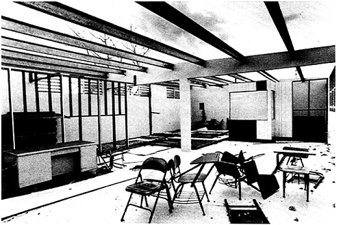
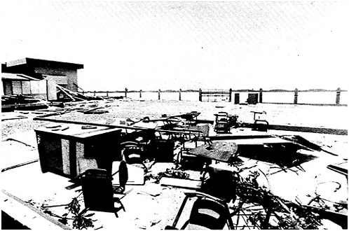
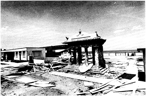
FIGURE 3-2b A second view of the Rosendo Matienzo Cintron School in Luquillo, Puerto Rico, used as a shelter during Hurricane Hugo.
thousands of prefabricated housing units for the families who had lost their homes (El Mundo, October 17, 1989, p. 8; and San Juan Star, November 9, 1989, p. 24).
As stated above (p. 76), the effective sheltering of evacuees depended on cooperation and coordination among municipal civil defense officers, commonwealth agencies, and a private organization. It did not occur, in part because of the links of this disaster-preparedness subsystem with the political system of Puerto Rico.
Civil defense officials, in trying to explain to the reconnaissance team their problems with sheltering evacuees, mentioned that commonwealth officials discriminated against their municipalities because the current governor's political party did not carry their municipalities during the last general elections. While the accuracy of these statements cannot be verified, they represent a definition of the situation that is widespread on the island, namely, the assumption that the receipt of government services is linked to partisan voting. An alternative —to give the municipalities entire operational responsibility for the shelters—was voiced in the Puerto Rican Congress in the aftermath of the crisis (El Mundo, September 30, 1989, p. 4), but was firmly resisted by the commonwealth government.
WATER AND POWER SUPPLIES AFTER HUGO LANDFALL
El Carraizo Dam
The failure of El Carraizo Dam—operated by the Commonwealth Aqueduct and Sewer Authority (Autoridad de Acueducto y Alcontarillado, AAA)—to provide water after the occurrence of Hurricane Hugo is described more completely in Chapter 4.
As is not unexpected in the aftermath of a disaster, the efforts by the Puerto Rican government and congress centered on the identification of the AAA officials responsible for the lack of upkeep of El Carraizo Dam. A more systematic understanding of the causes of the problems with the dam and elsewhere in Puerto Rico is in order (FEMA, 1985). Such an approach would encourage focusing on longer-term solutions; for example, to strengthen the disaster preparedness system and the emergency response capability of Puerto Rico.
Political factionalism weakens professionalism among public employees and distorts hiring and promotion decisions in the public bureaucracies. Recent mass media accounts of public employment in Puerto Rico indicate possible widespread violation of the principle of merit based on technical proficiency, and professionalism (El Mundo, October 15, 1989, pp. 2-5). Reportedly, the practice of using temporary workers, who are not required to take entrance examinations, often circumvents the registers of qualified applicants.
Another concern is the inconsistent enforcement of existing land-use pattern regulations. Unregulated residential and commercial development on Puerto Rico is placing many residents at risk.
A satisfactory analysis of these and other problems and how they impact disaster preparedness is needed. The analysis should examine the chronic inability of the Puerto Rican economy to provide opportunities for social mobility for a sizeable proportion of the population and how this creates the structural conditions leading to an overriding dependence on the government bureaucracies as sources of employment. The economic, cultural, and social assumptions of disaster programs and policies designed for mainland communities should be carefully reviewed before they are applied to Puerto Rico.
Autoridad de Energia Electrica
The failure of El Carraizo Dam and the subsequent disarray of the AAA stands in sharp contrast to the rapid reestablishment of electrical power by the AEE. The AEE response began on September 19, after a long planning session a day earlier (El Vocero, October 14, 1989, p. 24). The quick response by AEE to solve the problems caused by Hurricane Hugo is commendable; the electricity generating capacity was never curtailed by the storm. Instead, the problem AEE confronted was one of distribution (El Nuevo Dia, September 21, 1989, p. 15). It should be pointed out,
however, that AEE's operational practices overloaded electric poles and made the system vulnerable to the effects of high winds. Many failures of transmission lines were documented (Rodriguez et al., 1990, p. 8). Clearly, there is a need to stop the practice of running excess electrical lines, as well as to harden the electric distribution system on the island.
More than 30 towns were initially without electricity, half of them in the eastern zone. Severe damage to the electricity distribution system occurred in San Juan and in the areas of Canovanas, Luquillo, Fajardo, Naguabo, Ceiba, San Lorenzo, Vieques, and Culebra (El Mundo, September 21, 1989, p. 3). By September 24, newspaper reports indicated that power had been reestablished to more than 60 percent of the metropolitan area, although five towns—Fajardo, Ceiba, Rio Grande, Vieques, and Culebra—were still without electricity (El Nuevo Dia, September 24, 1989, p. 6; and El Mundo, September 27, 1989, p. 9). Rapid improvements occurred during the next few days, so that by the week of November 9, only 10 to 30 percent of the houses in 17 towns still lacked electricity (San Juan Star, November 9, 1989, p. 24).
RECOMMENDATIONS
-
While EBS worked well, it needs to be strengthened by the inclusion of more radio stations in the opinion of some of the team's respondents.
-
The study team supports NOAA's recommendation that the upgraded NOAA Weather Wire be implemented in Puerto Rico and the Virgin Islands as soon as practicable. The NWS should work with FEMA to explore funding of the system for critical outlets (NOAA, 1989, p. 103).
-
One remaining question is the extent to which the San Juan WSFO is connected with civil defense offices in municipalities from the San Juan metropolitan area. More and better quality communication equipment is necessary to strengthen these links. In Puerto Rico, NOAA Weather Wire is still dependent on a landline system (NOAA, 1989, pp. 38-39). Moreover, its weather products are fed into the Commonwealth Civil Defense Office, which in turn distributes them to other civil defense offices throughout Puerto Rico and to the mass media via radio link. With the exception of the city of Ponce, most “municipio CDs do not have a drop on the weather wire nor on NOAA Weather Radio” (NOAA, 1989, p. 79). The lack of hardcopy weather products for use by the civil defense officials in these municipalities creates a potentially inefficient process that should be corrected. While Hurricane Hugo did not test this part of the disaster-preparedness system, a future hurricane could.
-
The SLOSH model service, used for the analysis of hazards in San Juan, was extremely effective in the case of Hugo and should be extended to serve other coastal municipalities on the island.
-
There is a pressing need for a social science comparative study of disaster-related programs and emergency services in Puerto Rico to determine their relative effectiveness and opportunities for improvement.
-
There is a clear need for a systematic assessment of (1) the engineering readiness of buildings used for shelters in Puerto Rico and their appropriateness for a variety of natural hazards, (2) the relative accessibility and potential demands for shelters in different areas, and (3) public opinion about shelters, their location, and their desirability and safety, to serve as the basis for effective educational and public policy that would strengthen the shelter readiness of the commonwealth.
-
The municipal governments of the Commonwealth of Puerto Rico should formulate formal agreements among themselves for the planned and orderly distribution of evacuees when disasters occur.
-
There is a need for a multidisciplinary study to determine the most efficacious program to provide long-term temporary housing for shelter residents.
-
The lack of maintenance of El Carraizo Dam (see Chapter 4) requires more detailed analysis of all dams and water supply systems in Puerto Rico.
-
The electrical distribution system should be modified to reduce its vulnerability to high winds and earthquakes.
REFERENCES
Commonwealth of Puerto Rico. 1987. Puerto Rico Flood Hazard Mitigation Plan. Department of Natural Resources, Resources Planning Area.
FEMA. 1985. Federal Interagency Flood Hazard Mitigation Team Report for Puerto Rico, In Response to the October 10, 1985, Disaster Declaration. FEMA-746-DR-Puerto Rico, FEMA Region II. 1985. Washington, D.C.: Federal Emergency Management Agency.
National Oceanic and Atmospheric Administration. 1989. NOAA Disaster Survey Report. Hurricane Hugo September 15-22, 1989. December 1, 1989.


