
1
Radio Frequency Regulation for the Scientific Services
1.1 FREQUENCY PROTECTION GOALS FOR THE SCIENTIFIC SERVICES
Preservation and promotion of frequency allocations for scientific services have a significant societal impact. For example, the international frequency allocations for the Earth Exploration Satellite Service (EESS) enable scientific studies of the entire Earth’s biosphere, including global measures of soil and water content. These EESS studies provide critical information on issues impacting the global economy, including essential economic sectors such as food, transportation, and energy. The international frequency allocations for Radio Astronomy Service (RAS) enable a wide range of scientific studies, including exploration of the origin of our solar system and the detection of radio emission originating from the edge of the observable universe. The results of RAS studies provide context for our place in the universe and inspire the next generation of scientists. Preserving interference free access to the radio spectrum for scientific use is thus crucial both to provide information on the conditions of our planet Earth that have global consequences and to enable discoveries that will lead to a better understanding of the natural world.
Scientific research that uses the radio spectrum benefits from U.S. radio-frequency managers who work with national and international regulatory bodies to improve spectrum access for the scientific services throughout the world. This includes working with radio-frequency managers of other Administrations1 at World Radiocommunication Conferences (WRCs) to preserve and promote both federal and international allocations for scientific uses. For example, it is important to protect bands allocated to the science services from emissions spilling over from adjacent bands in order to ensure the efficacy of scientific research. Of the several scientific services (see Table 1.1), the passive-use allocations to the RAS and the EESS are particularly vulnerable to interference because noise levels must be extremely low in order to detect the faint signals generated by natural phenomena and processes. In this context, it is important that regulatory actions do not change the radio regulations in ways that would be deleterious to RAS and EESS, even when these services are not considered explicitly.
_____________
1 An “administration” is any governmental department or service responsible for international telecommunications regulation.
TABLE 1.1 Scientifically Relevant Services
| Service | Abbreviation | Description of Service |
| Earth Exploration Satellite Service | EESS | Remote sensing from orbit, both active and passive, and the data downlinks from these satellites |
| International Global Navigation Satellite System (GNSS) Service | IGS | Accurate position and timing data |
| Meteorological Aids Service | MetAids | Radio communications for meteorology, e.g., weather balloons |
| Meteorological Satellite Service | MetSat | Weather satellites |
| Radio Astronomy Service | RAS | Passive ground-based observations for the reception of radio waves of cosmic origin |
| Space Operations Service | SOS | Radio communications concerned exclusively with the operation of spacecraft—in particular, space tracking, space telemetry, and space telecommand |
| Space Research Service | SRS | Science satellite telemetry and data downlinks, space-based radio astronomy, and other services |
NOTE: Chapters 2, 3, and Section 1.5 describe how these services contribute to scientific endeavors.
The science services are protected both by frequency allocations and by some special geographic restrictions on other users, such as the geographic restriction in the National Radio Quiet Zone that includes the National Radio Astronomy Observatory’s facility in Green Bank, West Virginia. However, in practice, most spectral allocations are shared with active services and, with the introduction of higher-powered space transmitters and the use of spread spectrum modulation techniques, both EESS and RAS are increasingly vulnerable to interference, even in their protected bands. Thus, while spectral sharing of the passive service allocations with compatible active service allocations are possible in some circumstances, special care must be taken to provide protection for scientifically critical spectral windows and for geographic regions where radio telescopes are located. Of particular concern are those radio emissions that exist very close to the atomic and molecular spectral line frequencies reserved for the scientific services. For example, for many years, RAS allocations for observations of hydroxyl (OH) between 1610.6 and 1613.8 MHz have been impacted negatively by interference from the sidebands of spaceborne transmitters, even though their central transmitting frequencies lie outside the radio astronomy bands. It is particularly difficult to avoid interference from airborne and spaceborne transmitters, because radio telescopes are directed upward and terrain shielding (the use of geographical features to block radio signals) cannot be utilized to block transmission originating from high altitude. Novel approaches for effective spectral sharing need to be developed to enable efficient use of the radio spectrum for scientific and other applications.
Radio regulations are formulated at several levels and involve a plethora of acronyms (see Appendix H). At the international level, regulations for use of the radio spectrum that will become treaty obligations of members of the International Telecommunication Union (ITU) are formulated at World Radiocommunication Conferences. The ITU Radiocommunications Sector (ITU-R) prepares material for these conferences and drafts recommendations that may be incorporated into regulations or, at the very least, are influential documents for telecommunications regulators and spectrum users around the world.
Much of the work of the ITU-R takes place through its Study Groups, which are further organized into working parties and task groups. These deal with specific areas or problems and provide studies of questions concerning technical and procedural aspects of radio communications. Study Group 7 has responsibility for use of the spectrum for scientific research (the science services): remote sensing systems are the concern of Working Party 7C (WP7C), and radio astronomy is the concern of Working Party 7D (WP7D). The other services under Study Group 7 are WP7A, time and frequency standards, and WP7B, space research and EESS (mostly communications). In the past, the communications aspects of the EESS had been assigned to WP7C rather than WP7B. However, WP7B is now concerned with communications between spacecraft as well as from the spacecraft to the ground. Indeed, without the communications protected by WP7B, it would be almost impossible to conduct science from space.
Additional input from the scientific community comes from the Scientific Committee on Frequency Allocations for Radio Astronomy and Space Science (IUCAF), which operates under the auspices of the International Council of Scientific Unions (ICSU) that operates under the aegis of the United Nations Educational, Scientific, and Cultural Organization (UNESCO). IUCAF is sponsored by three international scientific unions: the International Astronomical Union (IAU), the International Union of Radio Science (URSI), and the Committee on Space Research (COSPAR).
The work of the ITU-R results in an extensive system of formal documents that includes the following:
- Questions—which specify the subjects to be studied within the study groups;
- Recommendations and reports—which record the conclusions from these studies; and
- Regulations—which are adopted by adhering administrations and have treaty status. Footnotes may provide additional information, and often provide protection to particular services on a primary or secondary basis.
ITU Study Groups (SGs) can elaborate on Recommendations that may be approved between WRCs or at a Radiocommunication Assembly, which is held just before a WRC. WRCs are large, diplomatic meetings that now take place approximately every 3 to 5 years. Even though Recommendations are not mandatory, most administrations abide by them. WRCs revise the Radio Regulations, and once accepted by administrations, the Radio Regulations become part of a treaty and thereby become mandatory. The SGs contribute to a WRC through their input to the draft Conference Preparatory Meeting (CPM) Report.
The relationship among national and international radio regulatory and advisory bodies with respect to RAS and EESS is complicated. See Figures 1.1 and 1.2, which depict the connections among many of these agencies and their relationship to one another both nationally and internationally.
Within the United States, non-federal-government use of the spectrum is regulated by the Federal Communications Commission (FCC). Federal government use is regulated by the National Telecommunications and Information Administration (NTIA), which is part of the U.S. Department of Commerce. Most, if not all, spectrum use for scientific research is under shared federal government/non-federal-government jurisdiction. Many federal agencies have spectrum-management offices—for example, the Department of Defense (DOD), National Aeronautics and Space Administration (NASA), and the National Science Foundation (NSF). The Inter-department Radio Advisory Committee (IRAC) is a standing committee that advises NTIA with respect to the spectrum needs and use by departments and agencies of the U.S. government. In practice, NTIA and IRAC see every pending FCC frequency allocation that could impact federal government allocations—including the scientific services. NTIA, with advice from IRAC, then interacts with the FCC to determine the final outcomes.
The U.S. administration has set up national-level study groups, working parties and task groups that mirror those that operate within the ITU-R. For example, U.S. WP7C, part of U.S. Study Group 7,

FIGURE 1.1 This Radio Astronomy Service (RAS) diagram depicts the complex relationship among the national and international radio regulatory bodies for RAS. The color coding is designed to highlight similar agencies and connections between the international and domestic (U.S.) organizations. For example, yellow and orange colors indicate ITU- and U.S.-based study groups. U.S. federal agencies are highlighted in shades of blue, green, and red, while international and domestic science committees and communities are denoted in beige.
develops U.S. positions and draft documents concerning remote sensing (U.S. WP7D does so for RAS, and U.S. WP7B does so for the Space Operations Service [SOS] and Space Research Service [SRS]). These documents are reviewed by the U.S. International Telecommunication Advisory Committee (ITAC) and, if approved, are forwarded by the U.S. Department of State to the ITU-R as input for international meetings.
In the United States, radio astronomers, remote sensing scientists, and others who use the passive and active bands for scientific research can interact with the system of spectrum management through the Committee on Radio Frequencies2 (CORF) of the National Academies of Sciences, Engineering,
_____________
2 CORF is a standing committee of the National Academies of Sciences, Engineering, and Medicine operating under the auspices of the Board on Physics and Astronomy. For more information on CORF, see its website at http://sites.nationalacademies.edu/bpa/bpa_048819.
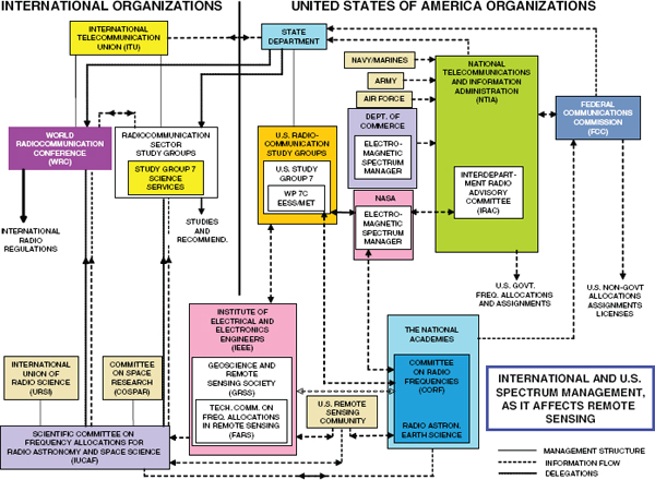
FIGURE 1.2 This Earth Exploration Satellite Service (EESS) diagram depicts the complex relationship among the national and international radio regulatory bodies for the EESS. The color coding is designed to highlight similar agencies and connections between the international and domestic (U.S.) organizations. For example, yellow and orange colors indicate ITU and U.S.-based study groups. U.S. federal agencies are highlighted in shades of blue, green, and red, while international and domestic science committees and communities are denoted in beige.
and Medicine, and U.S. WP7A, WP7B, WP7C, and WP7D, all of which hold meetings that are open to the public. They can also communicate with the spectrum-management offices of the NSF and NASA, the FCC (through public proceedings and ex parte comments, described at https://www.fcc.gov/exparte) and NTIA, and with members of IUCAF.
As indicated above, CORF is a committee of the Academies, which are private, nonprofit institutions that provide expert advice on some of the most pressing challenges facing the nation and the world. CORF serves as a link between the radio astronomy and remote sensing communities and the spectrum-management offices at the NSF, NASA, and the National Oceanic and Atmospheric Administration (NOAA). CORF participates in public proceedings of the FCC.
The scientific needs of radio astronomers for the allocation of frequencies were first addressed at the World Administrative Radio Conference (predecessor of the WRC) held in 1959 (WARC-59). Astronomers proposed the following:
- That the science of radio astronomy should be recognized as a service in the radio regulations of the ITU,
- That a series of bands of frequencies should be set aside internationally for radio astronomy—these should lie at approximately octave intervals above 10 MHz and should have bandwidths of about 1 percent of the center frequency, and
- That special international protection should be afforded to the hydrogen (H) line (1.400-1.427 GHz) and to the predicted deuterium (D) line (0.322-0.3286 GHz).
By the end of WARC-59, considerable action had been taken to meet these needs. RAS was established, and the first frequency allocations were made for this new service. At subsequent conferences, growing scientific needs were recognized and further steps were taken to meet them. For example, the discovery of many new interstellar molecular lines in the radio spectrum led to new frequency allocations and footnote protection. Radio astronomy research now extends into the millimeter and submillimeter wavelength bands, which are now recognized in new allocations and footnotes to the allocation table. At the WRC in 2000 (WRC-2000), the spectrum allocations above 71 GHz were revised, and a number of new allocations to RAS were made. Following WRC-2007, additional protections of the 1.400-1.427 GHz passive band were implemented to reduce unwanted emissions from the neighboring Amateur Service (AMT), Fixed Service (FS), and Mobile Service (MS). In addition, Resolution 739 (Rev. WRC-07) set unwanted emission thresholds for emission from satellite services in adjacent and nearby RAS allocated bands. WRC-2012 increased the upper end of the frequency range under consideration for allocations by the ITU from 1 to 3 THz and identified spectral windows where active service applications should take all practicable steps to protect the passive services from harmful interference, but did not impose mandatory protection criteria for passive services within the 275-1000 GHz frequency range.
An extensive discussion of the science enabled by RAS allocations is presented in Chapter 2 and the frequency bands allocated to RAS are listed in Chapter 5.
1.4 EARTH EXPLORATION SATELLITE SERVICE
Since many scientific programs require mapping of the entire Earth, regardless of geo-political boundaries, international cooperation is a critical requirement for EESS. Indeed, EESS is by its nature a global endeavor that relies on mutual cooperation among nations and their compliance with agreed-upon rules for access to the radio-frequency spectrum. Portions of the radio spectrum must be set aside to achieve the science goals of Earth-observing satellites, and their allocation must be respected globally. Thus, in sharp contrast to RAS, where protection of a few specific geographic locations may be sufficient, EESS requires global enforcement of the radio regulations.
EESS was established at WARC-71. Frequencies were allocated for the transmission of environmental data from space to Earth in order to accommodate the needs of satellite programs such as Landsat, which utilizes passive sensors operating in the visible part of the electromagnetic spectrum. EESS includes both active and passive uses and must use radio frequencies to send its data to Earth. Frequencies were first allocated to EESS and SRS for use by spaceborne active and passive microwave
sensors at WARC-79. That WARC made more than 50 allocations for spaceborne microwave sensors: 10 for active sensors and more than 40 for passive sensors.
By 1997, there was a need to improve the regulatory environment for spaceborne microwave sensors. Spectrum requirements for passive sensors had been refined in the 18-year interval between 1979 and 1997, particularly in the unique 50-70 GHz region where measurements in the vicinity of oxygen absorption lines are used to determine atmospheric temperature profiles for use in weather forecasts and climate studies. Also, time had shown that the secondary footnote allocations made for active microwave sensors in 1979 were of little use in preventing new allocations from being made to other services—allocations that could (and did) cause active sensors to be unusable owing to interference.
At WRC-97, passive remote sensing bands between 50 and 60 GHz were realigned. Most active remote sensing bands were upgraded to primary allocations. In the EESS communications area, the 8025-8400 MHz band was upgraded to a primary allocation, and a new wider-bandwidth space-to-Earth allocation was obtained at 26 GHz.
At WRC-2000, the passive bands above 71 GHz were realigned, and the top of the range was extended from 275 GHz to 1 THz via a footnote. The 18.7 GHz passive band gained protection, as did civilian Global Positioning System (GPS) bands.
At WRC-2003, an active band at 437 MHz was allocated, and the active sensing band at 5.3 GHz was expanded in bandwidth from 210 MHz to 320 MHz, but at the cost of losing protection against outdoor radio local area networks at the low end. Of particular concern, up/down communication links near the 1.400-1.427 GHz passive band were given a provisional secondary allocation pending further study and a report to WRC-2007. Note that any emissions in this band are explicitly prohibited by international footnote 5.340. Following WRC-2007, additional protections of the 1.400-1.427 GHz passive band were implemented to reduce unwanted emissions from neighboring AMT, FS, and MS services. In addition, mandatory unwanted emissions limits were adopted for FS in bands neighboring the EESS allocations at 10.6-10.68, 31.3-31.5, 50.2-50.4, and 52.6-54.25 GHz. WRC-2012 adopted additional protections for the 86-92 GHz band.
An extensive discussion of the science enabled by EESS allocations is presented in Chapter 3, and the frequency bands allocated to EESS are listed in Chapter 5.
Other frequency allocations support scientific research, and many are, in fact, essential to the operation of spacecraft, observation, and the retrieval of data. While some of these services (i.e., radionavigation and communications) are incorporated within the science services, they are clearly indispensable, and their importance should be recognized.
1.5.1 The Meteorological Satellite Service and Meteorological Aids Service
Earth science studies of climate and weather often rely on information gathered from weather satellites and weather balloons. The Meteorological Satellite Service (MetSat) and the Meteorological Aids Service (MetAids) provide communication to weather satellites and weather balloons, respectively. Thus, while not used to collect or generate scientific data directly, the more than 1900 radiosonde stations located worldwide, which support nearly 1 million launches of weather balloons per year, provide measures of pressure, temperature, humidity, and vertically sampled wind profiles that are critical to the interpretation and analysis of EESS scientific research, and thus are included in the broad list of scientific services.
1.5.2 The Space Research and Space Operations Services
SRS and SOS need to be protected and managed in order to enable the scientific community to operate spacecraft and to retrieve data taken by them. Without these bands, spaceborne science cannot be carried out.
SRS covers the communications services necessary for spacecraft launch and for data communications with spacecraft. The major network supporting space exploration and space science is the NASA Deep Space Network (DSN), an international network of antennas operated by the Jet Propulsion Laboratory for NASA. The DSN supports interplanetary spacecraft missions and radio and radar astronomy observations for the exploration of the solar system and the universe. The network also supports some Earth-orbiting missions.
The majority of Earth-orbiting missions are supported by Earth stations located throughout the globe. At present, more than 100 Earth stations have the capability of receiving high rate (more than 100 Mb/s) stored data from low Earth-orbiting EESS satellites using the 8025-8400 MHz EESS communications band. An additional 130 Earth stations can receive medium rate (20 Mb/s) real-time data directly from some EESS satellites when such data are needed for immediate use. The EESS tracking telemetry, and command functions, generally use S-band (around 2 GHz) and a subset of the EESS Earth stations.
EESS Earth stations may be dedicated to individual missions (e.g., NOAA’s meteorological satellite ground stations and the International Ground Station Network operated by the U.S. Geological Survey to support Landsat). Other Earth stations may work in concert to service many missions (e.g., NASA’s Near Earth Network). Earth stations located at very high latitudes are particularly effective at servicing polar, or near-polar, orbiting satellites because only two Earth stations (e.g., Fairbanks, Alaska, and Svalbard, Spitzbergen, Norway) are needed to contact the satellite and collect data at least once each orbit. At one time, NASA operated a “picket fence” of 12 Earth stations, spread from North to South to obtain one contact per orbit with equatorial-orbiting spacecraft.
Another communications path is via a data relay satellite, such as NASA’s Tracking and Data Relay Satellite System (TDRSS). The data relay satellite then forwards the data from another satellite to the ground via a K-band link, and forwards commands in the reverse direction to the satellite. The TDRSS uniquely provides 24-hour uninterrupted communications when mission operations require it (e.g., the inhabited International Space Station).
SRS also includes communications for space radio astronomy (space-based very long baseline interferometry) using antennas in Earth orbit. The spacecraft transmit the data to ground stations for processing and analysis.
1.5.3 Frequency, Time, and Position Systems
The Standard Frequency and Time Signal-Satellite Service, as well as navigational systems used by the scientific community, provide position data needed for measurements of motions of Earth’s crust and glaciers as well as for spacecraft navigation. They also sometimes support intrinsic scientific uses in addition to navigational purposes—for example, measurements of general relativity.
These systems provide timing measurements orders of magnitude more accurate than any other system. GPS provides timing with an accuracy that can be exceeded only by having an atomic clock located in a laboratory.
The International Global Navigation Satellite System (IGS), formerly the International GPS System, is a voluntary federation of more than 200 worldwide agencies that pool resources and permanent navigation satellite station data to provide the highest-quality data and products in support of Earth
science research, multidisciplinary applications, and education. Currently the IGS includes two Global Navigation Satellite Systems (GNSSs)—GPS and the Russian Global Navigation Satellite System (GLONASS)—and intends to incorporate future GNSSs, such as Europe’s Galileo system. While the IGS is primarily used by the EESS for spacecraft position and timing information in support of remote sensing, occultation of IGS transmissions through the limb of the atmosphere provide high-quality data used for temperature and humidity profile with exceptional vertical resolution. These data are assimilated into numerical weather forecast models. There are also experimental scientific uses of IGS for radio science and bistatic radar. NASA has funded the Cyclone GNSS (CyGNSS) mission to study tropical cyclone winds using the reflected IGS from ocean waves. This technique has the potential to observe oceanic winds in all conditions.
1.6 THE ECONOMIC VALUE OF THE SCIENCE SERVICES
1.6.1 Investments in Infrastructure
Radio astronomy and Earth science require the operation of many facilities with different instruments and locations, including the vantage point of space. Countries around the world that have made major investments in the development of radio astronomy and Earth science include Argentina, Australia, Brazil, Canada, China, Germany, France, India, Italy, Japan, The Netherlands, Russia, Sweden, the United Kingdom, and the United States. As a return on those investments, radio astronomy and Earth remote sensing have, over the past decades, made fundamental new discoveries and have brought us closer to understanding both the nature of the universe and our immediate environment. The rapid rate of important discoveries in radio astronomy and Earth science will surely continue if the radio-frequency bands for the passive services are protected.
1.6.2 Technologies and Techniques Developed from Radio Astronomy
Because scientific discoveries are usually made at the limits of instrumental sensitivity, radio astronomy and remote sensing have contributed significantly to the development of new technology for medical, commercial, industrial, and defense purposes. Radio astronomy has been a copious source of transferable technology, algorithms, and trained individuals interested in applying remote sensing and receiver expertise in a variety of sectors, and especially in telecommunications.3 Some examples are listed below:
- Originally developed as a radio astronomical technique for the high-resolution imaging of astronomical objects, very long baseline interferometry (VLBI) is used for applications in Earth science—for example, the determination of geophysical parameters used in studying plate tectonics, polar wandering, latitude measurements, and variations in Earth’s rotation, and the identification of potential earthquake zones through the precise measurement of fault motion.
- The VLBI reference frame of celestial coordinates, based on extremely distant radio sources, is basic to the periodic calibration of the GPS reference clocks.
_____________
3 National Research Council, Spectrum Management for Science in the 21st Century, The National Academies Press, Washington, D.C., 2010, p. 130; International Telecommunication Union, ITU Handbook on Radio Astronomy, 2nd ed., Geneva, Switzerland, 2013, p. 4.
- Pulsar and VLBI observations are used to examine and test Einstein’s general theory of relativity; timekeeping, precision navigation, and geodesy—including that of spacecraft—require consideration of general relativistic effects.
- VLBI instrumentation is the source of the technology used to locate interference to commercial satellite uplinks.
- John O’Sullivan and collaborators at the Commonwealth Scientific and Industrial Research Organisation were working on improving the quality of radio images made using interferometry and patented a related technique for reducing multipath interference in network radio transmissions, a critical component of wireless networks (WiFi).
- Using radio astronomy and laboratory experiments, Sir Harold Kroto made the surprising discovery that long linear carbon chain molecules existed in interstellar space and also in stars. During laboratory attempts to understand how these species came to be so abundant, fullerene molecules were discovered. Kroto shared the Nobel Prize in chemistry in 1996 with Richard Smalley and Robert Curl.
- Astronomers played a significant role in refining the hydrogen maser clock, which is now an important frequency standard in applications requiring high-precision (1 part in 1015) frequency stability over periods of ~1000 seconds.
- Computerized x-ray tomography employs software and methods originally developed for mapping radio sources. The data-intensive computing and storage systems that are developed for signal processing in areas such as pulsar searches have wide applications elsewhere.
- Extremely sensitive, low-noise receiver technology developed for radio astronomy has been used in implementing the Enhanced 911 emergency service.
- Amplifiers developed for millimeter-wave and THz local oscillators are finding their way into point-to-point wireless systems.
Radio astronomers have adapted their methods of measuring microwave temperature for the noninvasive detection of tumors and other regions of vascular insufficiency. Microwaves have poorer angular resolution than infrared has but are more sensitive to deep-tissue temperatures. Astronomers were also the first to employ conical (circularly polarized) feed horns, which later became popular on satellite transmitters because both polarizations could be transmitted by the same feed horn. Linear polarizations require spatially separated crossed rectangular feeds.
1.6.3 The Value of Satellite Remote Sensing
Satellite remote sensing is one of the cornerstones of meteorology, oceanography, and environmental science, supporting analysis and research that provide assessments, predictions, and warnings to the public.4 Weather- and climate-sensitive industries account for about one-quarter of the U.S. gross domestic product. Droughts, severe storms, and floods account for more than $20 billion in damage annually in the United States. The impact of El Niño events on the U.S. economy is estimated at $25 billion.5 Without satellite remote sensing, the ability of the atmospheric and oceanic science community to monitor, analyze, and predict environmental conditions would be drastically diminished. Satellites provide the only means of providing accurate assessments of land- and sea-surface and atmospheric conditions on a global scale and are a critical component for better understanding and predicting the trajectory of Earth’s
_____________
4 ITU-R Report RS.2178 (10/2010).
5 Stanley A. Changnon, Gerald D. Bell, David Changnon, Vernon E. Kousky, Roger A. Pielke, Jr., Lee Wilkins, El Niño, 1997-1998: The Climate Event of the Century, Oxford University Press, New York, 2000.
climate. Remotely sensed information from passive and active microwave sensors is increasingly being used to provide guidelines for environmental policy decisions.
Satellite remote sensing has long been used to estimate sea-surface temperature through passive radiometry. Sea-surface temperature impacts the atmosphere as a forcing field, coupling between the ocean and atmosphere through sensible and latent heat and freshwater fluxes. Until recently, cloud cover severely limited sea-surface temperature retrievals, but microwave techniques are now routinely used to see through clouds to provide accurate sea-surface temperature retrievals under almost all weather conditions. The availability of complete coverage with relatively fine temporal and spatial resolution is crucial to models of ocean and atmosphere coupling and variability. It has also provided new insights into the mechanism of transport of moisture over the globe, for example, the identification of intense trans-Pacific jets of moisture (“atmospheric rivers”) that facilitate most of the meridional transport of water vapor from the tropics to the middle latitudes, along with the production of devastating winter storms along the western U.S. coast.
Satellite remote sensing contributes greatly to surface-oriented science. Examples include the Shuttle Radar Topology Mission, which provided a consistent, near-worldwide, digital elevation model for the first time and the breakthrough glacial observations made with Radarsat, which mapped the entirety of Antarctica. Radarsat, along with in situ GPS-based measurements, is providing the first large-scale measurement of glacial motions, critical for climate studies. Further, interferometric synthetic aperture radar (InSAR) and differential InSAR are providing new tools used to measure subtle movements in Earth’s crust, for example, the subsidence areas exhibiting soil compaction or water table retreat or the buildup of surface strain along crustal fault lines.
Some examples of valuable microwave satellite remote sensing applications are listed below:
- The geographic delineation of forest fire extent through smoke by their microwave radiation;
- The measurement by passive remote sensing techniques of the temperature of Earth’s atmosphere; surface properties including soil moisture, snow cover, and sea ice; the distribution of water vapor, cloud water, precipitation, and impurities such as carbon monoxide; and vegetation biomass properties;
- The monitoring of trace gases, such as ozone, important to atmospheric chemistry, air quality, and greenhouse warming;
- Early and accurate warnings of natural land-related disasters, and the mitigation of such events;
- Systematic environmental monitoring and the generation of information relevant to better management of natural resources, including forests, agricultural lands, wetlands, and freshwater;
- The mapping of conditions with potential for malaria outbreaks and other disease vectors;
- Studies of human impact on the environment—for example, urban development, deforestation, and diversion of natural waterways; and
- The measurement, using the newly allocated EESS secondary active band at 432-438 MHz (via footnote 5.279A), of Amazonian biomass (in conjunction with higher-frequency radar measurements of the top of the vegetation), as well as allowing measurements of soil, underlying brush cover, and soil prone to landslides in the western United States.
The potential loss of any critical band for EESS could be expected to result in significant costs to society, resulting from reduced ability to forecast weather and the environment, manage resources, and predict disruptive climate changes.
The costs of severe weather events alone are often in the hundreds of millions of dollars per event. NOAA’s National Weather Service forecasts, warnings, and the associated emergency responses result in a $3 billion savings in a typical hurricane season. Two-thirds of this savings, $2 billion, is attributed
to the reduction in hurricane-related deaths, and one-third of this savings, $1 billion, is attributed to a reduction in property-related damage because of preparedness actions. Errors in temperature and precipitation forecasting for even benign meteorological events such as local or regional heat or cold waves can cost U.S. utilities approximately $1 million per degree Fahrenheit daily as a result of an impaired ability to match energy supplies with demand.6 Although it is difficult to ascribe forecast errors to interference occurring within any specific microwave band, it is noted that undetected interference in any passive microwave band can seed the growth of large errors in numerical weather-prediction models. The costs of such forecasting errors are typically largest in areas of highest population density and thus of greatest spectral demand.
Although the key predictors of climate events remain a subject of debate, measurements of global moisture, cloud, snow, ice, and thermal distribution remain key values that are connected to regional weather patterns. Furthermore, the prediction of climate changes on all timescales shows increasing promise as global modes of oscillation, such as the El Niño-Southern Oscillation, Pacific Decadal Oscillation, and North Atlantic Oscillation, the teleconnections of these modes to regional climate, and the coupling of major large-scale climate subsystems are better understood. Indeed, as the ability to predict short-term climate improves, the utility of such measurements in making accurate climate predictions on both the short (monthly) and long (annual to decadal) timescales is anticipated to increase. Benefits to U.S. agriculture by altering planting decisions based on improved El Niño forecasts have been estimated at $265 million to $300 million annually, throughout El Niño, normal, and La Niña years. Costs associated with errors in predicting the onset of regional climate changes could thus easily amount to hundreds of millions of dollars per year.7
1.6.4 Education for Scientific Literacy
Both RAS and EESS science programs provide training and educational opportunities for students of all ages. Astronomy is a compelling subject, as shown by public attendance at planetariums, the number of astronomy and space magazines, and the very large number of astronomy clubs and amateur astronomers. This interest and involvement serves as an effective basis for using astronomy in the curriculum for kindergarten through grade 12 to improve the scientific literacy of tomorrow’s leaders and managers. Indeed, although at first glance they would seem too esoteric for such a purpose, radio telescopes have in fact proven very effective in education. For example, the Massachusetts Institute of Technology’s Haystack Observatory staff developed a Small Radio Telescope (SRT) and high school lesson plans as a tool to introduce students to the basics of radio astronomy. More than 100 SRTs were built from the original kits; as of 2012, the SRT has been re-designed so that it can be assembled from commercially available equipment, providing further educational opportunities as students build the telescope themselves.
The Angel Ramos Foundation Visitor and Educational Facility at the National Astronomy and Ionosphere Center (NAIC) in Arecibo, Puerto Rico, receives 100,000 visitors per year and conducts a number of training programs for students and teachers alike. Likewise, the National Radio Astronomy Observatory has visitor centers at the Very Large Array headquarters in Socorro, New Mexico, and at the Robert C. Byrd Green Bank Telescope in Green Bank, West Virginia. The Green Bank NRAO facility hosts many educational programs. Research at the National Radio Astronomy Observatory (NRAO) and NAIC has provided data for many Ph.D.s granted in the past 50 years, and both NRAO and NAIC run
_____________
6 National Oceanic and Atmospheric Administration, Economic Statistics for NOAA, 5th ed., April 2006.
7 National Oceanic and Atmospheric Administration, Economic Statistics for NOAA, 5th ed., April 2006.
summer Research Experience for Undergraduates programs. University radio observatories also provide hands-on training for the next generation of engineers and instrument builders as well as astronomers.
Earth remote sensing data are made publicly available at low cost or no cost via the Internet for use in schools. Landsat imagery, weather data, and most data from NASA and NOAA’s Earth Observing Satellite system are provided free of charge to U.S. researchers.8 For instance, digital elevation models from NASA’s February 11-22, 2000, Shuttle Radar Topography Mission that operated at 5.3 GHz is the most downloaded NASA data set of all time. Within the framework of the Global Earth Observation System of Systems, Earth remote sensing data are readily and rapidly distributed on a worldwide basis to support a wide range of activities by scores of countries within a number of societal benefit areas. The enhanced degree of awareness of Earth as a system stemming from such data use provides a myriad of educational benefits to all students around the globe.
_____________
8 National Research Council, Utilization of Operational Environmental Satellite Data: Ensuring Readiness for 2010 and Beyond, The National Academies Press, Washington, D.C., 2004; and National Research Council, Satellite Observations of the Earth’s Environment: Accelerating the Transition of Research to Operations, The National Academies Press, Washington, D.C., 2003.


