


Below is the uncorrected machine-read text of this chapter, intended to provide our own search engines and external engines with highly rich, chapter-representative searchable text of each book. Because it is UNCORRECTED material, please consider the following text as a useful but insufficient proxy for the authoritative book pages.
TransporTaTion research Board Washington, D.C. 2008 www.tRB.org N a t i o N a l c o o p e r a t i v e H i g H w a y r e s e a r c H p r o g r a m NCHRP SyntheSiS 384 Research sponsored by the american association of state highway and transportation officials in Cooperation with the Federal highway administration Subject AreAS Planning and administration, and Freight transportation Forecasting Metropolitan Commercial and Freight Travel A Synthesis of Highway Practice conSultAnt J. RiChaRD KUZMYaK silver spring, Maryland
NATIONAL COOPERATIVE HIGHWAY RESEARCH PROGRAM Systematic, well-designed research provides the most effective approach to the solution of many problems facing highway ad ministrators and engineers. Often, highway problems are of local interest and can best be studied by highway departments indi- vidually or in cooperation with their state universities and others. However, the accelerating growth of highway transportation devel- ops increasingly complex problems of wide interest to highway authorities. These problems are best studied through a coordinated program of cooperative research. In recognition of these needs, the highway administrators of the American Association of State Highway and Transportation Officials initiated in 1962 an objective national highway research program employing modern scientific techniques. This program is supported on a continuing basis by funds from participating member states of the Association and it receives the full coopera- tion and support of the Federal Highway Administration, United States Department of Transportation. The Transportation Research Board of the National Research Council was requested by the Association to administer the research program because of the Boardâs recognized objectiv- ity and understanding of modern research practices. The Board is uniquely suited for this purpose as it maintains an extensive committee structure from which authorities on any highway transportation subject may be drawn; it possesses avenues of communication and cooperation with federal, state, and local governmental agencies, universities, and industry; its relationship to the National Research Council is an insurance of objectivity; it maintains a full-time research correlation staff of specialists in highway transportation matters to bring the findings of research directly to those who are in a position to use them. The program is developed on the basis of research needs iden- tified by chief administrators of the highway and transportation departments and by committees of AASHTO. Each year, specific areas of research needs to be included in the program are proposed to the National Research Council and the Board by the Ameri- can Association of State Highway and Transportation Officials. Research projects to fulfill these needs are defined by the Board, and qualified research agencies are selected from those that have submitted proposals. Administration and surveillance of research contracts are the responsibilities of the National Research Council and the Transportation Research Board. The needs for highway research are many, and the National Cooperative Highway Research Program can make significant contributions to the solution of highway transportation problems of mutual concern to many responsible groups. The program, however, is intended to complement rather than to substitute for or duplicate other highway research programs. NOTE: The Transportation Research Board of the National Academies, the National Research Council, the Federal Highway Administration, the American Association of State Highway and Transportation Officials, and the individual states participating in the National Cooperative Highway Research Program do not endorse products or manufacturers. Trade or manufacturersâ names appear herein solely because they are consid- ered essential to the object of this report. nchrp sYnThesis 384 Project 20-5 (Topic 38-07) ISSN 0547-5570 ISBN 978-0-309-09814-4 Library of Congress Control No. 2008907265 © 2008 Transportation Research Board copYriGhT perMission Authors herein are responsible for the authenticity of their manuscripts and for obtaining written permissions from publishers or persons who own the copyright to any previously published or copyrighted material used herein. Cooperative Research Programs (CRP) grants permission to reproduce material in this publication for classroom and not-for-profit purposes. Per- mission is given with the understanding that non of the material will be used to imply TRB, AASHTO, FAA, FHWA, FMSCA, FTA, or Transit development Corporation endorsement of a particular product, method, or practice. It is expected that those reproducing the material in this docu- ment for educational and not-for-profit uses will give appropriate ac- knowledgment of the source of any development or reproduced material. For other uses of the material, request permission from CRP. noTice The project that is the subject of this report was a part of the National Co-operative Highway Research Program conducted by the Trans- portation Research Board with the approval of the Governing Board of the National Research Council. Such approval reflects the Governing Boardâs judgment that the program concerned is of national importance and appro- priate with respect to both the purposes and resources of the National Research Council. The members of the technical committee selected to monitor this proj- ect and to review this report were chosen for recognized scholarly compe- tence and with due consideration for the balance of disciplines appropri- ate to the project. The opinions and conclusions expressed or implied are those of the research agency that performed the research, and, while they have been accepted as appropriate by the technical committee, they are not necessarily those of the Transportation Research Board, the National Research Council, the American Association of State Highway and Transpor- tation Officials, or the Federal Highway Administration of the U.S. Depart- ment of Transportation. Each report is reviewed and accepted for publication by the techni- cal committee according to procedures established and monitored by the Transportation Research Board Executive Committee and the Governing Board of the National Research Council. Published reports of the naTionaL cooperaTiVe hiGhWaY research proGraM are available from: Transportation Research Board Business Office 500 Fifth Street, NW Washington, DC 20001 and can be ordered through the Internet at: http://www.national-academies.org/trb/bookstore Printed in the United States of America
thE nationaL aCaDEMiEs Advisers to the Nation on Science, Engineering, and Medicine The National Academy of Sciences is a private, nonprofit, self-perpetuating society of distinguished schol- ars engaged in scientific and engineering research, dedicated to the furtherance of science and technology and to their use for the general welfare. On the authority of the charter granted to it by the Congress in 1863, the Academy has a mandate that requires it to advise the federal government on scientific and technical matters. Dr. Ralph J. Cicerone is president of the National Academy of Sciences. The National Academy of Engineering was established in 1964, under the charter of the National Acad- emy of Sciences, as a parallel organization of outstanding engineers. It is autonomous in its administration and in the selection of its members, sharing with the National Academy of Sciences the responsibility for advising the federal government. The National Academy of Engineering also sponsors engineering programs aimed at meeting national needs, encourages education and research, and recognizes the superior achievements of engineers. Dr. Charles M. Vest is president of the National Academy of Engineering. The Institute of Medicine was established in 1970 by the National Academy of Sciences to secure the services of eminent members of appropriate professions in the examination of policy matters pertaining to the health of the public. The Institute acts under the responsibility given to the National Academy of Sciences by its congressional charter to be an adviser to the federal government and, on its own initia- tive, to identify issues of medical care, research, and education. Dr. Harvey V. Fineberg is president of the Institute of Medicine. The National Research Council was organized by the National Academy of Sciences in 1916 to associate the broad community of science and technology with the Academyâs purposes of furthering knowledge and advising the federal government. Functioning in accordance with general policies determined by the Academy, the Council has become the principal operating agency of both the National Academy of Sci- ences and the National Academy of Engineering in providing services to the government, the public, and the scientific and engineering communities. The Council is administered jointly by both Academies and the Institute of Medicine. Dr. Ralph J. Cicerone and Dr. Charles M. Vest are chair and vice chair, respectively, of the National Research Council. The Transportation Research Board is one of six major divisions of the National Research Council. The mission of the Transportation Research Board is to provide leadership in transportation innovation and prog- ress through research and information exchange, conducted within a setting that is objective, interdis- ciplinary, and multimodal. The Boardâs varied activities annually engage about 7,000 engineers, scientists, and other transportation researchers and practitioners from the public and private sectors and academia, all of whom contribute their expertise in the public interest. The program is supported by state transportation depart- ments, federal agencies including the component administrations of the U.S. Department of Transportation, and other organizations and individuals interested in the development of transportation. www.TRB.org www.national-academies.org
nchrp coMMiTTee For proJecT 20-5 chair CATHERINE NELSON, Oregon DOT MeMBers KATHLEEN S. AMES, Illinois DOT STUART D. ANDERSON, Texas A&M University CYNTHIA J. BURBANK, PB Americas, Inc. LISA FREESE, Scoot County (MN) Public Works Division MALCOLM T. KERLEY, Virginia DOT RICHARD D. LAND, California DOT JAMES W. MARCH, Federal Highway Administration MARK A. MAREK, Texas DOT JOHN M. MASON, JR., Auburn University ANANTH PRASAD, HNTB Corporation ROBERT L. SACK, New York State DOT FRANCINE SHAW-WHITSON, Federal Highway Administration LARRY VELASQUEZ, New Mexico DOT FhWa Liaison WILLIAM ZACCAGNINO TrB Liaison STEPHEN F. MAHER Cover photo: Hudson Yards, used by the Long Island Railroad and NJ Transit. cooperaTiVe research proGraMs sTaFF CHRISTOPHER W. JENKS, Director, Cooperative Research Programs CRAWFORD F. JENCKS, Deputy Director, Cooperative Research Programs NANDA SRINIVASAN, Senior Program Officer EILEEN DELANEY, Director of Publications nchrp sYnThesis sTaFF STEPHEN R. GODWIN, Director for Studies and Special Programs JON M. WILLIAMS, Associate Director, IDEA and Synthesis Studies GAIL STABA, Senior Program Officer DONNA L. VLASAK, Senior Program Officer DON TIPPMAN, Editor CHERYL KEITH, Senior Program Assistant Topic paneL CHARLES M. BABER, Baltimore Metropolitan Council KUO-ANN CHIAO, New York Metropolitan Council ALAN HOROWITZ, University of WisconsinâMilwaukee ELAINE KING, Transportation Research Board MARK SCHLAPPI, Phoenix, Arizona HUI WEI SHEN, Florida Department of Transportation FRANKLIN L. SPIELBERG, Vanesse Hangen Brustlin LINDA TURNQUIST, California Department of Transportation BRIAN GARDNER, Federal Highway Administration (Liaison) EDWARD L. STROCKO, Federal Highway Administration (Liaison)
This synthesis report identifies methods of freight and commercial vehicle forecasting currently in professional practice, along with promising methods emerging from ongoing research. The primary focus is on metropolitan-level forecasting, although some consid- eration is given to statewide freight models. The report finds that metropolitan freight and commercial vehicle forecasting is being performed through the use of traditional four-step models, which have inherent limitations for this purpose. A critical gap continues to be the inability to collect data from shippers or carriers that are reluctant to divulge confidential business information. Information to perform the synthesis was gathered by literature review, including advanced international practice. In addition, a survey and interviews were conducted of nine selected North American metropolitan planning organizations to ascertain their expe- rience in the development and application of freight and commercial forecasting tools. J. Richard Kuzmyak, consultant, Silver Spring, Maryland, collected and synthesized the information and wrote the report. The members of the topic panel overseeing this project are acknowledged on the preceding page. This synthesis is an immediately useful docu- ment that records the practices that were acceptable within the limitations of the knowledge available at the time of its preparation. As progress in research and practice continues, new knowledge will be added to that now at hand. Highway administrators, engineers, and researchers often face problems for which infor- mation already exists, either in documented form or as undocumented experience and prac- tice. This information may be fragmented, scattered, and unevaluated. As a consequence, full knowledge of what has been learned about a problem may not be brought to bear on its solution. Costly research findings may go unused, valuable experience may be overlooked, and due consideration may not be given to recommended practices for solving or alleviat- ing the problem. There is information on nearly every subject of concern to highway administrators and engineers. Much of it derives from research or from the work of practitioners faced with problems in their day-to-day work. To provide a systematic means for assembling and evaluating such useful information and to make it available to the entire highway commu- nity, the American Association of State Highway and Transportation Officialsâthrough the mechanism of the National Cooperative Highway Research Programâauthorized the Transportation Research Board to undertake a continuing study. This study, NCHRP Proj- ect 20-5, âSynthesis of Information Related to Highway Problems,â searches out and syn- thesizes useful knowledge from all available sources and prepares concise, documented reports on specific topics. Reports from this endeavor constitute an NCHRP report series, Synthesis of Highway Practice. ForeWord preFace By Jon M. Williams Program Director Transportation Research Board
conTenTs 1 SUMMARY 5 CHAPTER ONE INTRODUCTION Purpose of Study, 5 Organization of the Report, 5 7 CHAPTER TWO RATIONALE FOR AND CHALLENGES IN MODELING FREIGHT AND COMMERCIAL VEHICLE TRAVEL Compelling Circumstances, 7 Freight Modeling Challenges, 8 Important Trends, 9 10 CHAPTER THREE FREIGHT MODELING CONCEPTS AND OPPORTUNITIES Desirable Model Characteristics, 10 A Modeling Hierarchy, 11 Application of the Four-Step Model Process to Freight, 15 25 CHAPTER FOUR PLANNING RESOURCES, RESEARCH, AND DATA Major Sources of Information Relevant to Metropolitan Freight and Commercial Vehicle Forecasting, 25 International Experience, 29 Emerging Methods, 32 Data Needs, Issues, Resources, and Collection Techniques, 38 Urban Freight Data, 40 42 CHAPTER FIVE SURVEY OF METROPOLITAN PLANNING ORGANIzATION PRACTICE Purpose And Approach, 42 Overview of Findings, 43 67 CHAPTER SIX CASE STUDIES Case Study 1: Use of Ohio Statewide Freight Model to Improve Metropolitan Freight Planning, 67 Case Study 2: Oregon Travel and Land Use Integration Program Commercial Travel Model, 68 Case Study 3: Los Angeles Countyâs Cube Cargo Model, 69 Case Study 4: Calgary Tour-Based Commercial Vehicle Model, 70 76 CHAPTER SEVEN CONCLUSIONS AND RESEARCH SUGGESTIONS Lessons Learned, 76 Research Suggestions, 77 79 REFERENCES 84 BIBLIOGRAPHY 89 GLOSSARY OF TERMS AND ACRONYMS Acronyms, 92 93 APPENDIX A MPO SURVEY/INTERVIEW GUIDE Survey of MPO Freight and Commercial Vehicle Practice, 93
96 APPENDIX B PROFILES OF MPO FREIGHT MODELING PRACTICE Atlanta Regional Commission, 96 Baltimore, 101 Chicago, 106 Detroit, 107 Los Angeles, 112 New York, 117 Philadelphia, 121 Phoenix, 123 Portland, 127
sUMMarY ForecasTinG MeTropoLiTan coMMerciaL and FreiGhT TraVeL Trip-making characteristics for commercial (e.g., service-related) and freight travel are very different from person travel, and are often not well represented in metropolitan travel models. Metropolitan travel forecasts, therefore, may underpredict commercial and freight travel because of lack of data, or overpredict other components of travel, such as nonâ home-based trips to compensate and match traffic counts. Trucks have special impacts on traffic, pavements, and air quality and truck travel may be affected by climate and security events. Finally, the level of transport service afforded to commercial and freight travel has significant bearing on the overall costs of doing business in a metropolitan area, and studies to evaluate the economic development of transportation or land use alternatives must be advised by accurate forecasts of commercial and freight travel. This synthesis project has been conducted to identify methods of freight and commer- cial vehicle forecasting currently in professional practice, along with promising methods emerging from ongoing research. The methods are described in relation to data collec- tion, model estimation, and model validation, accompanied by applications case studies. Information to perform the synthesis has been gathered by literature review, including advanced international practice. In addition, a survey was conducted of nine selected North American metropolitan planning organizations (MPOs) to ascertain their experience in the development and application of freight and commercial forecasting tools. An increasing number of MPOs are attempting to model freight and commercial vehicle travel. However, as recently as 2006, a national survey revealed that only slightly more than half (55%) of all MPOs had a procedure currently in place, although large MPOs were much more frequently involved in freight modeling (79%) than those in medium (55%) or small (46%) metropolitan areas. MPOs that do model freight are actually modeling heavy trucks, and in some instances, light commercial vehicles, using a variation of the conventional four-step process involving trip generation, distribution, and assignment. A formal mode choice step is not employed because alternatives to truck (e.g., rail) are not considered in the urban transportation realm. Distinction among the different truck classes is done for trip generation, distribu- tion, and assignment, but conventional urban truck models do not compute âchoiceâ among types of truck. Focusing on trucks is a defensible limitation for MPOs because trucks account for more than 80% of freight movement in most metropolitan areas, and trucks are at the core of numerous metropolitan transportation planning concerns, including Truck volumes on crowded regional roadways, visibly contributing to traffic conges-⢠tion, delay, and breakdowns; Involvement of heavy trucks in a high percentage of fatal crashes;⢠Contribution of heavy, diesel-powered trucks to emissions of regulated pollutants ⢠such as nitrogen oxide (NOx) and fine particulate matter (PM-2.5);
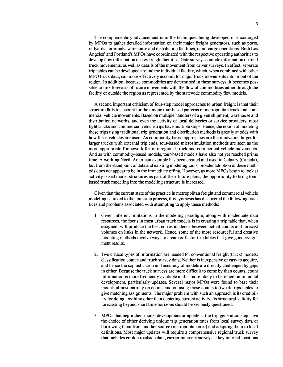
2 Noise impacts; and⢠Accelerated wear of pavements and intensified stress on bridges.⢠Weighing against these negative impacts is the acknowledged importance of efficient freight flow to the local economy. Efforts to improve the ability of trucks to move within and through the region must be judged in relation to the impacts associated with those move- ments. These are complex issues, the tradeoffs among which demand capable planning tools and reliable data. Critics of the four-step process being applied to truck travelâincluding MPOs them- selvesâgenerally point to commodity-based approaches as structurally superior. Freight activity levels reflect a âderived demandâ for freight transportation, the product of goods and services moving through the economy. These goods and services take the form of com- modities, whose production levels and distribution are directly tied to the functioning of the regional, national, and global economy. Commodity-based freight models on the other hand first concern themselves with accurately representing the flow of goods through the economy, and second with the translation of those flows to freight movements by particular modes. Many MPOs are aware of these methods and their benefits, but none have attempted to completely shift to a full commodity-based framework. There are numerous reasons for this. First, there are no working prototypes that can be evaluated or copied, so the concept at the metropolitan area is still untested and out of the mainstream. Second, data on commodity flows are not readily availableâmeaning they must be purchased from private sourcesâand are typically presented at too high a level of aggregation (i.e., county) to be directly useful in an MPO model. Third, these models have a structure (spatial equilibrium inputâoutput) that is foreign to most MPOs, whose expertise, plans, and programs have been meticulously built around the four-step process. The exception may be those areas that possess integrated transportationâland use models, such as PECAS or UrbanSim, which have such a structure and theoretically can be used for freight modeling. However, none of the MPOs surveyed in this project were found to employ such an approach for freight planning. In the absence of an explicit tie to commodities, MPO models are obliged to represent activity outside their borders with truck volumes at external stations. This is problematic in two ways. First, accurate statistical measurement of flows at the regional cordon requires substantial classification counts to determine the number and types of vehicles moving, but must also obtain originâdestination data from the trucks themselves to ascertain the orienta- tion of these trips into, out of, or directly through the region. The expense and difficulty of obtaining these data limit their collection or quality and, correspondingly, the accuracy of the simulation. Second, external flows determined in such a fashion have virtually no con- nection with economic market determinants that explain their current or future levels. Two important opportunities were observed in this synthesis that offer to fill this gap. The first is the steady advancement of statewide models with viable freight components. The second is the growing practice among MPOs to focus more energy and resources on understanding flows at major regional freight generators. Statewide models offer a natural basis for a commodity-based connection for MPO regional models. Their structure is at a sufficiently high level of aggregation that they can make use of both public and private commodity flow data, which can then be linked with economic forecasts for future plan- ning. These models also generally include more than one freight mode (truck), and hence can address issues of policies or investments to shift freight from one mode to another (e.g., truck to rail). Michigan, Ohio, and Oregon are all examples of states where methods have been developed to link the outputs and geography of the statewide network with the traffic analysis zone network of the MPO models.
3 The complementary advancement is in the techniques being developed or encouraged by MPOs to gather detailed information on their major freight generators, such as ports, railyards, terminals, warehouse and distribution facilities, or air cargo operations. Both Los Angelesâ and Portlandâs MPOs have coordinated with the respective operating authorities to develop flow information on key freight facilities. Gate surveys compile information on total truck movements, as well as details of the movement from driver surveys. In effect, separate trip tables can be developed around the individual facility, which, when combined with other MPO truck data, can more effectively account for major truck movements into or out of the region. In addition, because commodities are determined in these surveys, it becomes pos- sible to link forecasts of future movements with the flow of commodities either through the facility or outside the region as represented by the statewide commodity flow models. A second important criticism of four-step model approaches to urban freight is that their structure fails to account for the unique tour-based patterns of metropolitan truck and com- mercial vehicle movements. Based on multiple handlers of a given shipment, warehouse and distribution networks, and even the activity of local deliveries or service providers, most light trucks and commercial vehicle trips have multiple stops. Hence, the notion of modeling these trips using traditional trip generation and distribution methods is greatly at odds with how these vehicles are used. As commodity-based approaches are the innovation target for larger trucks with external trip ends, tour-based microsimulation methods are seen as the more appropriate framework for intraregional truck and commercial vehicle movements. And as with commodity-based models, tour-based models have also not yet reached prime time. A working North American example has been created and used in Calgary (Canada), but from the standpoint of data and existing modeling tools, broader adoption of these meth- ods does not appear to be in the immediate offing. However, as more MPOs begin to look at activity-based model structures as part of their future plans, the opportunity to bring tour- based truck modeling into the modeling structure is increased. Given that the current state of the practice in metropolitan freight and commercial vehicle modeling is linked to the four-step process, this synthesis has discovered the following prac- tices and problems associated with attempting to apply these methods: Given inherent limitations in the modeling paradigm, along with inadequate data 1. resources, the focus in most urban truck models is in creating a trip table that, when assigned, will produce the best correspondence between actual counts and forecast volumes on links in the network. Hence, some of the more resourceful and creative modeling methods involve ways to create or factor trip tables that give good assign- ment results. Two critical types of information are needed for conventional freight (truck) models: 2. classification counts and truck survey data. Neither is inexpensive or easy to acquire, and hence the sophistication and accuracy of models are directly challenged by gaps in either. Because the truck surveys are more difficult to come by than counts, count information is more frequently available and is more likely to be relied on in model development, particularly updates. Several major MPOs were found to base their models almost entirely on counts and on using those counts to tweak trips tables to give matching assignments. The major problem with such an approach is its credibil- ity for doing anything other than depicting current activity. Its structural validity for forecasting beyond short time horizons should be seriously questioned. MPOs that begin their model development or update at the trip generation step have 3. the choice of either deriving unique trip generation rates from local survey data or borrowing them from another source (metropolitan area) and adapting them to local definitions. Most major updates will require a comprehensive regional truck survey that includes cordon roadside data, carrier intercept surveys at key internal locations
4 (terminals, warehouses, distribution facilities), and possibly establishment surveys. It is believed that the relationship between the employment and household variables in the trip generation equations and the economic sectors that relate to those variables allows the model to be used for forecasting. However, this use requires the assump- tion that productivity relationships between the given employment type and freight movements will remain constant over time. There is no substitute for good, current data on freight movements. A critical gap 4. continues to be the ability to collect data from shippers or carriers that are reluctant to divulge confidential business information. The only substitute to date has been to pur- chase private data that have been cleaned and protected in such a manner as to mini- mize disclosure. Many states and MPOs contacted in this synthesis have acquired the private TRANSEARCH database to assist in model development or updates, and some MPOs (Southern California Association of Governments or Portland Metro) have conducted supplemental local data collections to leverage the information from TRANSEARCH. Technology may also begin to provide some assistance, particularly in the use of videography to aid in classification counts and the use of geographic information system and Global Positioning System methods to assist in the collection, processing, and validation of originâdestination survey data. These are the primary findings and conclusions from this synthesis review of metropoli- tan freight and commercial vehicle forecasting. The review raises concerns about potentially inadequate processes and data, but it also offers encouragement on areas where innovative new approaches or better data could greatly enhance the current state of the practice. The final chapter of this report offers recommendations for additional investigations that can be useful in propagating the development and implementation of some of these new methods to improve MPO freight and commercial vehicle forecasting.
5 Although some information was known to exist on specific areasâ experience with freight modeling, that information was sufficiently uncoordinated that a special effort was made to contact a sample of metropolitan planning organizations (MPOs) and systematically investigate their experience with and approaches to modeling freight. This report is neither a best practices guide nor a com- prehensive state-of-the-practice assessment of metropolitan freight modeling. Rather, it offers a systematic and in-depth review of the issues that are being faced and approaches that are being taken to model freight movements at a cross section of major MPOs whose regions are known to have significant freight activity. The goal is to draw the connection between the types of demands being placed on the planning process by local freight issues, explain the process by which the respec- tive MPO chose the particular approach, and in so doing pro- vide practical insights on current practice as well as on those areas offering the greatest opportunity for improvement. orGanizaTion oF The reporT Following this introduction, the remainder of this report is structured as follows: Chapter two sets the context for metropolitan involve- ment in freight and commercial vehicle forecasting. It begins with a discussion of the motivations encouraging MPOs to develop freight planning tools, and then discusses the basic challenges in attempting to model freight activity. A critical aspect of this challenge lies in essential differences between person travel and commercial vehicle movements. The most salient of these characteristics in terms of the makeup of the freight industry and key trends that affect freight transporta- tion decisions are then presented. Chapter three provides an overview of freight modeling concepts and practice. The characteristics that are desired in freight models are contrasted with what is actually being done. A framework is presented that suggests a hierarchy in the aspects of freight that are modeled at different levels of spatial aggregationâglobal, national, state, regional, and localâand how these techniques attempt to correspond with the types of information that are available versus the types of planning and forecasting issues that are of greatest concern. Model- CHAPTER ONE inTrodUcTion pUrpose oF sTUdY The level of importance attached to freight transporta- tion activity in metropolitan areas has grown steadily over the past 10 to 15 years. Federal mandates are responsible for some of this attention, requiring freight to be formally included in the transportation planning and funding process and air quality conformity requirements that underscore sig- nificant contributions from diesel-powered freight vehicles. However, more immediate concerns have taken hold in the metropolitan areas themselves, reflecting the rapid growth of commercial vehicle traffic, competition for increasingly scarce road capacity, conflicts with smaller passenger vehi- cles, accelerated wear rates for pavements and bridges, and concerns about congestion impacts on both economic pro- ductivity and quality of life. At the same time, metropolitan areas keenly recognize the importance of good commercial access to a healthy, growing, and diversified economy; hence, they need better tools for assessing the inherent tradeoffs. From a technical perspective, however, efforts to incorpo- rate freight into metropolitan transportation planning mod- els have lagged noticeably behind the attention accorded to person travel. Partly this has to do with the greater size and visibility of the passenger travel segment, and partly to the need for improved tools for facility planning and traffic man- agement largely linked to passenger movements, and par- ticularly to peak period congestion issues. However, it also because freight transportation is different in nature from person travel, and neither existing data sources nor modeling approaches neatly conform to the special characteristics of freight. Faced with limited budgets and competing priorities, freight has historically not commanded the highest attention from planning agencies. Moreover, no one in either in the federal government or the academic or research community has ever proposed a âbest practicesâ approach for metropoli- tan freight modeling and forecasting. In that light, the purpose of this project has been to pro- vide an overview of the methods that are being used to fore- cast freight and commercial vehicle travel in metropolitan areas. It has identified and reviewed relevant studies, papers, reports, and planning guides that help explain the setting in which metropolitan freight planning occurs, the available tools and data with insights on their use, and new concepts that are emerging from research and advanced application.
6 Chapter six offers a set of case studies intended to illus- trate or explore tools, applications, and methods that are exemplary in some fashion, and provide insights to planning agencies that are currently confronting or will be confront- ing similar issues. The case studies are: Use of Ohio Statewide Freight Model to Improve ⢠Metropolitan Freight Planning Oregon Travel and Land Use Model Integration ⢠Program Commercial Travel Model Los Angeles Countyâs Cube Cargo Model⢠Calgary Tour-Based Commercial Model⢠Chapter seven concludes the report with a summary of the studyâs findings and major lessons learned. It includes recommendations for future research and other measures to improve the tools and data available to MPOs for forecasting freight and commercial vehicle travel. References and a Glossary of Terms, Abbreviations, and Acronyms are provided at the end of the report narrative. Also included are the following appendices: Appendix A provides a copy of the questionnaire used in the survey of MPOs. Appendix B contains the profiles of current practice as derived from the survey of MPOs. ing approaches at each level of this hierarchy are reviewed, supplemented with examples where available. A key discus- sion focuses on the potential benefits of integrating state and metropolitan modeling capabilities as opposed to attempting to reshape metropolitan models to be commodity based. Chapter four provides an overview of technical resources, research, and data. It starts with a summary of key studies, reports, and planning guides that were identified in the litera- ture review. This is followed by a review of the international experience in modeling freight, particularly at the regional and urban levels. There is then a discussion of emerging methods that are coming out of domestic or international research or that are being developed and tested in a number of areas. The chapter concludes with a discussion of freight data needs, sources, and collection methods. Chapter five summarizes the findings from the survey of MPOs. An overview of the survey process and data items obtained is followed by a cross-comparative analysis of how the motivations and resources differed across the sample of MPOs and the linkage with the modeling approaches used. Detailed profiles prepared for each MPO surveyed document circumstances with regard to setting, issues, and customer base that are driving the interest in freight modeling. This is then accompanied by a review of the methods in use, procedures, and data used for their development, data resources and chal- lenges, capabilities, and plans for future modeling approaches or enhancements. These profiles are provided in Appendix B.
7 late emissions, at levels far beyond their proportion in the regional traffic stream. Internally, metropolitan areas discovered other important reasons to be more active and thorough in their treatment of freight. Among the many issues involving freight transpor- tation are Congestion:⢠Roadway congestion is at critical levels in many U.S. metropolitan areas, with levels of vehi- cle-miles of travel (VMT) increasing faster than new capacity can be provided. Commercial truck volumes have been growing at a much faster rate than those for automobiles, and projections from the FHWA Freight Analysis Framework (FAF) suggest that freight flows will double in the nation over the next 20 years. Environmental Impact: ⢠Of particular interest is the effect of heavy-duty diesels on NOx, fine particulate matter (PM-2.5), and greenhouse gas emissions. Safety⢠: Mixing of heavy trucks with smaller passenger vehicles on crowded highways raises the risks of colli- sions, with a high percentage of such collisions result- ing in fatalities for occupants of the smaller vehicle. Noise:⢠Heavy trucks significantly increase noise levels in the vicinity of urban highways, frequently requiring intervention. Economic Sustainability⢠: Freight access and effi- ciency are tied to current and future business location decisions and investment. Regional economic health also relies on efficient and reliable access to manufac- turers, suppliers, ports, terminals, warehouses, and customersâboth inside and outside the region. In attempting to address these issues with appropriate mitigation strategies, MPOs find they need better informa- tion and tools to assess the performance and effectiveness of such strategies as Air quality mitigation/emission reduction strategies ⢠aimed at heavy-duty vehicles (HDVs); Channeling truck flows onto or away from specific ⢠facilities, such as discouraging through trucks from a metropolitan areaâs radial freeways and arterials; Tolls and congestion pricing measures;⢠The ability to conduct freight movement, facility loca-⢠tion, or access studies in relation to the local economy, coMpeLLinG circUMsTances As noted in the Introduction, the heightened interest in understanding freight activity and attempting to better incorporate it in both state and regional planning is the result of both external and internal factors. Externally, pres- sure to consider freight in transportation planning appeared in the early 1990s with passage of the 1991 Intermodal Sur- face Transportation Efficiency Act (ISTEA) and the 1990 Clean Air Act Amendments (CAAA). ISTEA introduced the term âintermodalâ into contemporary planning jargon and practice, suggesting that transportation demand should be viewed from the perspective of the user rather than the transportation provider. Instead of focusing piecemeal on individual links and modes in the transportation network, ISTEA (and its successors TEA-21 and SAFTEA-LU) stressed the importance of planning for the âtotal trip,â causing greater emphasis to be placed on balance and con- nectivity in the transportation system. ISTEA also matched major new funding for transportation with new require- ments for monitoring the condition and performance of the transportation system and making upkeep and preservation of the existing system a first priority when identifying sys- tem financial needs. In the specific case of freight, it was keenly recognized that the shipment of goods had become increasingly âmultimodal,â that is, involving handling by more than one mode or carrier in transport from shipper to consumer. In relation to the management and preservation of system âassets,â the impact of increased pavement and bridge wear from growing volumes of heavy truck use was also made apparent. Air quality also created a clear motivation for includ- ing freight in transportation plans and programs. Not only did the 1990 CAAA establish stringent new standards for ambient air quality that affected many U.S. metropolitan areas, but through its âtransportation conformityâ provision required transportation plans and programs to conform to an agreed-on timetable for achieving the national standards as set forth in the state implementation plan. Whereas off- road freight modes such as rail, water, and air did not fall under the provision for transportation conformity, meaning that MPOs were not responsible for their emission contri- butions, trucks were included in regional mobile source air quality budgets. Diesel power in many of these trucks con- tributed substantially to nitrogen oxide (NOx) and particu- CHAPTER TWO raTionaLe For and chaLLenGes in ModeLinG FreiGhT and coMMerciaL VehicLe TraVeL
8 Many goods found in retail stores are now delivered ⢠from distribution centers, rather than their manufac- turer. Delivery patterns that are optimal for distribu- tion centers and other intermediaries are different from when they were shipped by the producer. Such move- ments are often made by truck fleets whose travel is organized into tours with many more stops than person travel and have different sensitivities to travel time and network delay. These characteristics call for different analytical approaches than are used for person travel, as well as specialized data. One question is whether truck travel can be effectively modeledâand, in particular, forecastâwithout a direct linkage to the economic activity that is creating the demand for the movement of particular commodities. Another ques- tion is whether truck travel can be simplistically represented through standard trip generationâtrip attraction methods or whether the basis for truck travel is rooted in unique tours. Truck travel is also likely to be governed by entirely different values of travel time and cost than person travel, which are again likely to vary by commodity. To begin to understand and attempt to create a framework for simulating freight transportation in general and truck travel in particular, special data are needed. Chief among these are vehicle classification counts and data on actual freight movements. The former are necessary to establish utilization levels of different classes of commercial vehicles on particular facility types, at particular locations, and at par- ticular times of day. Because traffic volume counts naively register only total vehicles crossing a reference line, it is necessary to visually record the composition of the vehicle stream, requiring either human involvement or use of tech- nology, either of which quickly raises costs. Data on actual freight movements are the source for key âbehavioralâ data such as type of commodity being moved, vehicle type, origin and destination, and nature of stops. These data can be obtained by indirect means, such as mail-back surveys, but are most accurate when there is human intervention in collecting the information. Typically, roadside surveys are used for this purpose, generally at the metropolitan cordon (boundary) in order to also gather criti- cal information on the number and nature of trips where the origin, destination, or both are located outside the region. Similar surveys might be conducted at major freight activity sites, such as ports or terminals. In any case, large samples are generally needed to deal with the high degree of vari- ability found in this type of data. The type, amount, and quality of these data have major implications for the types of modeling approaches that can be considered and the accuracy of the eventual methods. Many freight specialists believe that it is impossible to have a model that is credible for freight forecasting unless it is somehow future development plans, or changes in market condi- tions; and Projecting the volume of trucks on key facilities in ⢠relation to congestion, safety, noise, rates of wear, and so forth. FreiGhT ModeLinG chaLLenGes Although the level of interest in modeling freight activ- ity in metropolitan areas has been high, the challenges to developing effective models have been many. Chief among these challenges are the paradigm for modeling freight behavior and appropriate data to create reliable models. Most transportation planners and planning agencies have historically focused on analyzing person travel, almost uni- versally through application of some variation on the four- step modeling process. Given that framework, it has been a natural tendency to try to incorporate freight into the same behavioral paradigm. However, even given a constrained definition of freight as truck travel in metropolitan models, trucks and other commercial vehicles operate much dif- ferently than the passenger vehicles with which they share the roads. In his freight modeling action plan for Atlanta (Donnelly 2005), Donnelly notes that despite an increased emphasis on freight at the federal level, there has been little federal guid- ance about exactly how to integrate freight into the planning process. He argues that it is neither simple nor appropriate to simply lump freight into the same paradigm with person travel, and cites the following reasons for that argument: Major changes in technology and markets, which have ⢠a direct bearing on freight demand, occur in much shorter cycles than the 20-year horizon often used in highway and transit planning. Many of the key factors influencing the growth in ⢠freight are not included in the socioeconomic fore- casting done by states and MPOs. Among these are changes in markets attributable to globalization of trade and continued competitive growth in intermodal rail, which are trends beyond the ability of most urban areas to analyze and forecast. Freight distribution patterns are decidedly differ-⢠ent from those for person travel. Although people may organize their travel around tours, rather than independent trips, the tour is still anchored around a primary purpose (e.g., shopping or travel to work). Freight movements, in contrast, are influenced by multiple âagents,â which often do not share the same goals or information. They include shippers, consum- ers, carriers, and intermediaries (distribution centers, warehouses, intermodal terminals, freight forwarders, customs brokers, breakbulk facilities, and third-party logistics firms).
9 providers that specialize in optimizing the distribution process. Centralized warehousing reduces the need to maintain inventories, which influences space require- ments, storage costs, and shelf loss, but translates to increases in transportation demand. In a paper prepared for the 2006 TRB freight conference, Turnquist (2006) emphasizes the role of improved logistics in evolving patterns of freight movement. He cites as one of the most important trends over the past 20 years the change in transportation and inventory costs as a share of Gross Domestic Product (GDP). Data are presented that show how combined inventory and transportation costs have steadily declined from more than 12% of GDP in 1985 to about 9% in 2004, or about 30%, with the biggest reason for this decline being the fall in inventory costs (from 6% to about 2%). These trends lead Turnquist to suggest three core ideas about how shippers and carriers operate that should be reflected in a good freight model: Shippers increasingly focus on total logistics cost 1. (transportation plus inventory) when they make deci- sions about how to ship materials across the supply chain. Paying more for faster, more reliable trans- portation is a key means to reduce inventory require- ments and, hence, logistics and production costs. The inventoryâtransportation cost evaluation is not 2. done in isolation, but has significant implications for location decisions and service quality as firms design their supply networks and product distribution net- works. The desire to provide faster delivery of prod- ucts to customers, using smaller and more frequent shipments, means that the outbound costs from distri- bution centers are relatively high. This in turn creates an incentive to locate distribution centers near major customers. As shippers have decreased shipment sizes in exchange 3. for increased frequency, carriers have responded by getting better at combining shipments in vehicles using cross-dock operations, special vehicle routing software to optimize routes with multiple stops, and reducing empty equipment repositioning costs. based on economic flows. Such a connection greatly raises the bar, however, in terms of data acquisition and handling, and introduces a new level of complexity to the modeling process that most MPOs have not seen as achievable, at least in the near term. iMporTanT Trends The freight industry has undergone tremendous change and upheaval over the past two decades because of multiple fac- tors, including technology, shifting of markets, industry practices, fuel prices, and others. Each of these trends speaks to a characteristic of freight transportation that adds further challenge to the goal of realistically modeling it. The follow- ing is a brief listing of key trends influencing freight trans- portation, as found in the original Quick Response Freight Manual (QRFM; Cambridge Systematics 1996): Globalization of Trade:⢠Not only are developing countries producing more and varied items for export, but domestic firms are increasingly shifting production facilities or purchasing components from overseas. Most worldwide freight flows are intermodal, involv- ing more than one mode and terminal exchange. The Economy:⢠The volume, types, and values of commodities produced and consumed reflect the con- dition of the economy; hence, freight flows and their distribution among modes are heavily determined by production and consumption cycles and the types of commodities that are in greatest demand (e.g., bulk vs. high value). Just-in-Time Inventory Practices:⢠Firms save costs by keeping inventory levels at minimum levels and coordinating delivery of supplies with production schedules. This results in more frequent inbound ship- ments, decreases the size of these shipments, and also places great importance on the timely receipt of these shipments. The impact is on the number of truck trips being made and possible shifts in the types of vehicles used for the deliveries and their distribution patterns. Centralized Warehousing:⢠As transportation systems have become more efficient and reliable, manufactur- ing firms are increasing their use of third-party logistics
10 represent these demands on the regionâs infrastructure and also have the sensitivity in its structure to evalu- ate actions to accommodate or mitigate the impacts of these demands. Turnquist (2006) also offers suggestions for characteris- tics that are important for effective freight models. The four characteristics he identifies are The model produces an output someone actually 1. wants and knows how to use. Freight models may be built with different ideas in mind about who will use the results and aim different types of models at dif- ferent users. Often, the user is an organization whose ability to use a model is constrained by its culture and knowledge. It is important to know who the eventual model users will be, the applications to which the model will be put, and that practitioners are properly trained in the use of the model. The model includes important variables that describe 2. how the system works and represents their interac- tions clearly and correctly. The freight system is com- plex, making it difficult to describe concisely what elements of the system are most important to repre- sent in the model. NCHRP Report 388 (Cambridge Systematics Inc. 1997) is recommended as an excel- lent guide in this process. A particular facet of freight transportation that is highlighted is the critical role of logistics (discussed in the previous chapter), which has significantly affected urban freight distribution patterns over the past 20 years. The model operates in a way that is understandable 3. and verifiable. Because model users are usually not model builders, they may fail to appreciate the elegant mathematical and statistical methods used to develop a model as opposed to the modelâs versatility, consis- tency, and transparency. It must produce results that are reasonable, defensible, and relevant. The model is based on data that can be provided so 4. that it can be calibrated and tested. The issue of sup- porting models with appropriate data is particularly relevant in the case of public sector freight forecast- ing. If models are to reflect the practical logistics CHAPTER THREE FreiGhT ModeLinG concepTs and opporTUniTies desiraBLe ModeL characTerisTics Given the special nature of freight transportation, there are a number of attributes that good freight models might be expected to incorporate. The Atlanta freight modeling action plan (Donnelly 2005) suggests the following features and capabilities: Ability to Depict Local Characteristics:⢠The model should be capable of depicting the unique characteris- tics of the metropolitan area for which it is developed. It should incorporate the areaâs major freight facilities and activity generators, communicate network con- nectivity and restrictions (which may be unique to the areaâs geography), and be able to represent those com- modities and activities that drive the local economy. Link with National and Regional Databases and ⢠Models: It should be possible to establish the context of the modeled metropolitan area within the overarch- ing state, national, and global economy, as depicted in state, national, or international databases and forecast- ing models. Freight flows into, out of, or through the region should have a tangible relationship with the out- side world, and the model should be able to distinguish between external trips that serve the region from those that are purely through trips. Link to Economic Trends and Forecasts:⢠Freight flows are economic flows carried on transportation networks. They are much more sensitive to changes in market structure and economic activity than per- son travel. This underscores the importance of relating freight trends to economic trends. An important impli- cation is that commodity flows, rather than vehicle flows, are the starting point for communicating these trends. Assumptions About Technological Change:⢠Because the effect of new technologies on shipping and dis- tribution patterns is so critical and changes in such short cycles, the modeling framework must be flex- ible enough to reflect these changes in a transparent manner. Ability to Examine Local Effects:⢠The principal driv- ers of freight demand are regional in nature, reflecting the metropolitan areaâs own production and consump- tion of goods, as well as its import and export of goods with the outside world. Thus, the model must be able to
11 network, which is both a familiar process and one that is closely tied to meeting regulatory requirements. Data:⢠Information for analyzing truck travel is already limited itself because of data collection costs and dif- ficulty, and obtaining information on commodities and tracking vehicles would add unrealistically to this bur- den. Public or private sources of commodity flow data are not sufficiently disaggregated for use at the metro- politan planning level. Relevance:⢠Trucks have a real and immediate signifi- cance to regional planning organizations given their visible role in traffic congestion, highway safety, air pollution, noise, and other issues to which the public and elected officials are sensitive. In addition to these reasons, a major factor cited in this projectâs MPO survey was the lack of evidence of an exist- ing, working version of such models. The related concern was that MPOs had limited resources and needed to be convinced that the additional time and effort for such a tool would be worth it in terms of additional accuracy or capability. Commodity flow-based freight models do exist, however, at the state and national level. The reasons for a greater pro- liferation at this level are that, first, commodity flow data are more available and at an appropriate level of aggregation for state models. Second, states are more likely than metropoli- tan areas to be concerned about economic competitiveness and efficiency and on the economic interchanges that accom- pany freight movements. Models incorporating logistics and distribution tours also have been developed, although with their acknowledged special data requirements and minimal testing to date. This separation of policy interests, modeling tools, and data availability suggests the existence of an effective âmodeling hierarchy,â where different levels of geography coincide with models of different structure and aggregation. A simple depiction of this might be as shown in Figure 1, ranging from models at the national or international level, state or corridor level, metropolitan area, and down to the distribution networks of shippers and carriers. In this hier- archy, the model at the top level addresses major national concerns of shippers and the ever-improving ability of carriers to optimize distribution with technology, having access to appropriate data for capturing such behavior is critical. However, these types of data are typically private and closely held because of their competitive nature. Turnquistâs conclusions following this assessment sug- gest an approach to freight flow forecasting that is quite dif- ferent from past practice. Such an approach would start with the decisions made by representative firms as they design their supply and distribution networks, including decisions on facility location, transportation and inventory levels, and service characteristics to their customer base. For specific movements in this network, a more detailed analysis of inven- tory and transportation costs would be done to create rep- resentative shipment sizes, frequencies, and mode choices. Then on the carrier side, these shipments would be translated into vehicle movements on an originâdestination basis. The data challenges in following such an approach are acknowl- edged, but moving in this general direction is described as critical if the profession is to seek greater understanding of freight movements and increase its ability to make effective public policy. a ModeLinG hierarchY The logical conclusion that is reached from the observations of Donnelly, Turnquist, and numerous other freight model- ing specialists is that a proper model of freight transporta- tion should be ultimately linked to the flow of commodities in the economy and also be capable of simulating real-world distribution patterns. This is not the situation one observes at the metropolitan planning level, however. Virtually all MPOs that model âfreightâ transportation are actually modeling âtrucks,â to varying degrees of speci- ficity and sophistication in terms of the classes of vehicles and the simulation methodology. There are several reasons that explain why MPOs limit their attention to trucks when modeling freight: Evolution:⢠Many MPOs have only become serious about trying to model freight within the past few years. The freight sector is sufficiently daunting in its com- plexity that it may be expected to take a while for local planners and decision makers to come up to speed with freight issues and relationships and develop comfort with simpler methods before pushing to advanced concepts. History:⢠Most MPOs conduct transportation planning through some variation of the four-step process, based on a long history of modeling person travel. Limiting the focus to trucks retains consistency with the genera- tion and assignment of vehicle trips to a transportation High-level economic flows and trade activity National/International Metropolitan/Urban Shipper/Carrier Truck tours between modes, on distribution centers, and customer Commodity flows by mode Truck flows by vehicle type metropolitan roadways State/Intercity Corridor FigURE 1 Freight modeling hierarchy.
12 gateways. The 2002 estimate is based on the 2002 Com- modity Flow Survey and other components of the Economic Census, for which data are collected every 5 years. Recog- nizing that goods movement shifts significantly during the years between each Economic Census, FHWA produces a provisional estimate of goods movement by origin, destina- tion, and mode for the most recent calendar year. The FAF estimates commodity movements by truck and the volume of long-distance trucks over specific highways. Models are used to disaggregate interregional flows from the commod- ity originâdestination database into flows among individual counties and assign the detailed flows to individual high- ways. The models are based on geographic distributions of economic activity rather than a detailed understanding of local conditions; hence, FHWA cautions that FAF estimates should not be seen as a substitute for local data to support local planning and project development. FAF relies extensively on existing data. The original model combined data from two principal sources: The TRANSEARCH database, a private database of ⢠county-to-county flows by commodity and mode pre- pared by Global Insight, and U.S. foreign trade data, consisting of monthly sum-⢠maries of imports and exports by commodity, mode of transportation, and trip end within the United States. Synthetic techniques were developed to allocate the for- eign trade data from the state to county level. Inputâoutput âmake and useâ coefficients for each industry were used to associate shipments with likely origins and destina- tions within each state. These flows were arrayed on a geo- graphic information system (GIS)-based representation of the national transportation system using minimum distance paths through the network. Forecasts of flows by origin, destination, and commodity were generated by Wharton Econometric Forecasting Associates (now part of Global Insight). A series of growth factors for each commodity was developed on the basis of detailed economic forecasts for each region of the country. The commodity growth rates in each region were constrained on the basis of a single national forecast. A similar methodology was used to esti- mate import and export flows within the United States, and exogenous forecasts of trade with other countries were used to forecast the growth in trade outside the United States. As with the domestic estimates, the trade forecasts were constrained to existing forecasts by gateway, commodity, and region of origin and destination. These growth rates were applied to base year flows to arrive at the forecasts. The baseline forecasts were supplemented by alternative domestic and trade forecasts that embodied assumptions about stronger and slower growth over the forecast period. The forecasts for international trade turned out to be 25% to 40% higher than those for domestic flows, varying by world region. and international economic flows, providing a system of control totals for states and economic regions to gauge over- all activity levels inspired by economic trends occurring nationally, but also reflecting global trade influence. The second tier of model is of the type developed by states and applied at a statewide level, or within intercity corridors. This model is more likely to be based on commodity flows, whose levels are linked to national economic trends, and then translating those commodity flows to freight flows on the basis of allocation to appropriate modes of carriage. The metropolitan model can then focus more specifically on the movement of trucks as one freight mode transporting goods within and across its boundaries. It can rely on the state model to provide it with commodity-based control totals for trucks at its boundaries, and then concentrate on meld- ing trips with one or more ends outside the metropolitan area with those trips generated and retained internally and distributing them across its highway network. At the finest level of detail in the hierarchy are the activities of shippers and carriers involved in goods distribution, engaged in the optimization of tours to maximize efficiency and minimize logistics costs. In a framework such as this, it might not be necessary for individual metropolitan areas to undertake development of fully integrated and commodity-based freight models. If a state model exists with the right characteristics, it would be possible and probably more efficient for the state and MPO to coordinate efforts. However, much depends on the rela- tionship between the MPO and the state, the existence and structure of the stateâs model, and other factors of compati- bility between models and data, including projected volumes at the metropolitan cordon line. national and international Models The FAF was developed by FHWA for use in policy and legislative analyses and, in particular, to address the need for comprehensive forecasts of intercity freight flow to help rationalize various Interstate highway corridor projects being advanced by local interests (Donnelly 2005). The FAF integrates data from a variety of sources to estimate commodity flows and related freight transportation activity among states, regions, and major international gateways. An original prototype of the FAF provided estimates of flows for 1998 and forecasts for 2010 and 2030, and a new version, FAF2, provides estimates for 2002 and the most recent year plus forecasts through 2035. More information on the FAF can be found at FHWAâs website: www.ops.fhwa.dot.gov/ freight/freight_analysis/faf/index.htm. In the FAF, a commodity originâdestination database estimates tonnage and value of goods shipped by type of commodity and mode of transportation among and within 114 areas, as well as to and from 7 international trading regions through the 114 areas plus 17 additional international
13 destination choice models and microsimulation of multistop âtours.â Some even account for commercial vehicles that are not carrying a commodity. However, perhaps the biggest difference between state and MPO models is the focus on commodity flows versus truck trips. Of those 15 states with freight models, 12 mod- els are based on forecasts of commodities. State four-step commodity models are truly multimodal in nature. They are generally calibrated from commodity flows, and the first forecasts in the modeling process are annual flows in tonsâa measure that is common across modes. The primary source used for this commodity flow data is the TRANSEARCH database, which may be teamed with data from other state and national sources, FHWAâs FAF model, and special road- side or establishment surveys. Most freight models that use commodities have many commodity categories. Among the states investigated in NCHRP Synthesis 358, the number of commodities contained in models ranged from 6 to 32, with 25 to 28 commodities being typical, generally based on relevance to the stateâs economy. Flows are then modeled geographically through application of an economic inputâ output type model that links flows to land use and employ- ment activity in traffic analysis zone (TAzs). Most models then allocate the resultant tonnage flows among the modes, including truck, rail, water, and air, even though the network assignment step usually deals only with trucks. Conversion of tonnage to vehicle flows requires knowledge of the typical vehicle âpayloadâ (tons per vehicle), obtained from either national public data (e.g., vehicle inventory and use survey or railcar load waybill sample) or special studies or data col- lections by the state. Because of the ready availability of freight originâdestina- tion data for the entire United States, a majority of statewide freight models cover most or all of the continental United States rather than relying on external stations at the state bor- ders. Half of the statewide freight components cover parts of either Canada or Mexico. For the out-of-state portions of freight models, none of the states chose to use national transportation analysis regions. Some used multiple types of zones, depending on how far the area is from the state border. Six of the states used counties or groups of coun- ties for these external areas, six used business economic area regions, six used states or groups of states, two used trans- portation analysis zones, one used external stations, and one used multistate regions. State-level freight models use spe- cial generators sparingly, and most models do not have any. These include railyards, airports, seaports, truck terminals, warehouses, distribution centers, and even regional shopping malls. An interesting exception is Florida, where the Florida DOT developed a heavy truck freight model for the stateâs ports (Cohen et al. 2008). The state was aware that its ports generated far more vehicle traffic than would be predicted by standard trip generation rates applied to the number of facil- ity employees. This approach is detailed later in this section. state and intercity corridor Models The next tier of models that may be of strategic assistance to metropolitan area efforts to model freight are the state, large region, and intercity corridor models. These models potentially represent a âstepping stoneâ from the large-area economic activity databases such as TRANSEARCH and commodity flow models such as FAF to freight flows and truck movements at a metropolitan level. Ideally, models at this level of the hierarchy would be fairly specific to the eco- nomic makeup, commodity base, transportation system, and special quirks indigenous to the state or economic region. Such models might also be expected to provide a translation from commodities to actual freight flows and truck volumes impinging on the respective metropolitan area. This would provide the metropolitan area with the ability to link its mod- eling process realistically with the economic forces driving the flow of freight into and through its borders, and to be able to focus on refining its internal modeling process while hav- ing a context with the world outside its borders. Statewide models, typically developed by state depart- ments of transportation (DOTs), have increased in number over the past decade, both for regulatory reasons and because more states are acknowledging complex transportation sys- tem performance, maintenance, and investment needs. In some states, freight issues are sometimes more important than person travel issues, particularly in states with high-vol- ume international border crossings, infrastructure deteriora- tion issues, or significant port facilities. Increased motivation notwithstanding, a recent NCHRP review of statewide travel forecasting models (Horowitz 2006) found that only 19 of 50 states and the District of Columbia currently have opera- tional statewide models, and only 15 of these have active freight components in those models: Florida, Georgia, Indi- ana, Kentucky, Louisiana, Michigan, Montana, New Jersey Ohio, Oregon, Tennessee, Texas, Vermont, Virginia, and. Wisconsin. The Montana and New Jersey statewide models are actually freight only. As these models increase in num- ber and sophistication, the opportunities presented for use of these models to complement MPO freight modeling efforts will also grow. This is particularly true for those MPOs where freight traffic into, out of, or through the region has major implications for transportation system performance and facility planning. As pointed out in the NCHRP Synthesis 358 (p. 28), the freight components of statewide models do more than sim- ply complement passenger modeling, as is typical for MPO models. Whereas most statewide models are a variant of the four-step process used almost exclusively by metropolitan areas, many have evolved to a level of sophistication well beyond what is seen in MPO models. For example, many statewide models employ linkages with inputâoutput models that match employment with commodities, and others are moving away from simple gravity models toward logit-based
14 sion of the TLUMIP effort is provided as a case study in chapter six. A high potential opportunity for state and MPO coordi- nation on freight modeling may reside in state corridor mod- els. NCHRP Report 606 profiles several examples of where states have developed truck models for interurban corridors that might present a specific venue for coordinated freight planning: Minnesotaâs Highway 10 Truck Trip Forecasting ⢠Model: To support a study of seven major intercity corridors, the Minnesota DOT developed a truck fore- casting methodology centered on Trunk Highway 10 (TH-10). The methodology applied direct flow fac- toring methods to historic truck count data to proj- ect future truck volumes. Trip generation rates taken from the QRFM were applied to regional employment forecasts to arrive at the estimate of future daily truck trips. No external market data, travel demand models, or intermodal terminal activity measures were used in the TH-10 procedure. Florida Heavy Truck Freight Model for Ports: The ⢠Florida DOT sponsored research intended to pro- vide planners with a tool for developing forecasts of freight traffic in the vicinity of Floridaâs major sea- ports, including Miami, Tampa, Jacksonville, and Port Everglades. Initial model development focused on the Port of Miami (a large container port) to estimate inbound and outbound heavy truck traffic. Similar to Minnesotaâs TH-10 model, the Florida port model is a direct facility flow factoring approach. Equations were developed using linear and autoregressive inte- grated moving average regressions of time series data to forecast future truck volumes. The model is a port- generated cargo truck estimation model and is not part of any larger demand model. However, it can be used to estimate productions and attractions from the port for inclusion as part of a statewide or regional model. Cross-Cascades Corridor Model: In 2001, the ⢠Washington State DOT (WSDOT) reached an agree- ment with state MPOs to develop a new planning and forecasting model that would integrate economic, land use, and transportation decisions and produce inter- regional forecasts across the full length of the Cross- Cascades corridor between Seattle and Spokane. WSDOT now uses this model to test the effects of transportation system changes on mode and route choice for passenger and freight, to forecast demand, and analyze issues statewide. The model was designed to be interfaced with the metropolitan models and is able to provide accurate estimates of external trips passing through the respective metropolitan areas in the corridor. The Cross-Cascades model is a spatial inputâoutput model (linked to a MEPLAN integrated land use model) that considers not only the level of Although the commodity-based models used by the states tend to be more complex, they also tend to have a greater sensitivity to economic trends and conditions and to state policies toward industrial development. What is perhaps of greatest relevance to the possible metropolitanâ state freight model connection is the manner and detail in which truck trips are projected from the state model. The first consideration in mating these modeling systems is in the presumed accuracy of the stateâs methodology and forecasts. Techniques for freight modal split in state models range from sophisticated logit models to the simple appli- cation of fixed shares with little or no sensitivity to reflect market- or policy-induced changes in shipping cost or other factors. A second consideration has to do with the compat- ibility of networks, vehicle types, time-of-day breakdowns, and similar issues. All 15 states in the NCHRP Synthesis 358 survey with freight model components generated estimates of truck flows. None of the models dealt directly with intermodal truck movements or industry-related distinctions among truck categories such as for-hire versus private truck. All had coded highway networks that were either truck specific or that had been modified for trucks, and almost all states combined all classes of trucks together, or dealt exclusively with heavy trucks. Only Michigan and Ohio divided trucks into heavy, medium, and light categories, consistent with how they are typically specified in MPO truck models. All states with a freight component do a 24-h forecast for trucks, although 5 states reported the ability to do a peak-period truck forecast. All truck networks have links that are coded to the same highway functional classes as passenger car net- works. These are all factors that would have to be taken into consideration in a coordinated modeling effort. The number of actual cases in which MPOs and states appear to be joining forces in their freight modeling capabil- ity at the time of this study was quite limited. Although Flor- ida, Ohio, Virginia, and Wisconsin have accomplished major advances in their freight models, no evidence of the type of formal coordination of the type suggested here appears to have yet occurred. This is a situation in itself that deserves additional research and exploration. In Oregon, the DOT is sponsoring development of a suite of integrated land useâtransport models under its Travel and Land Use Model Integration Program, or TLUMIP. This sophisticated statewide modeling tool is rooted in the PECAS software, whose underlying structure is that of an economic inputâoutput model. Metro, the MPO for the Portland area, has recently revised its truck model to make better use of new high-level information on activity at its port and railyards, and uses state commodity flow data to help in the quantification of external trip activity. Metro is anticipating a more formal linkage with the statewide model when it reaches a satisfactory stage of completion. A discus-
15 transportation and economic activities but also their interaction across the state. For models such as these to be useful to and welcomed by MPOs, there must be sufficient agreement on both sides that the modelâs structure, data, and forecasts are sound. Mod- els such as Minnesotaâs or Floridaâs might not necessarily be fully embraced by the respective MPOs because it is not clear that the MPOs were involved in its assumptions and develop- ment. These models base their forecasts more on trends than underlying forces in the economy, and hence could have their validity for forecasting questioned, particularly if they pro- duce a forecast that is notably higher or lower than what the local planners are anticipating. Models such as the example in Washington State (and also Oregon and Ohio) appear less likely to provoke such caution because those models are based on a much more comprehensive paradigm and appear to have involved MPOs in the design and development process. Metropolitan and Urban Freight Models In contrast to states, very few MPOs attempt to model freight. Instead, efforts to model urban freight movements have typically focused solely on truck flows and their impact on the roadway system. This is not surprising given that trucks are the most prominent, economically viable, and efficient means to move goods within an urban area. Early efforts to model trucks in the United States date back as far as efforts to model person travel, and many of these efforts have attempted to adapt the concepts of person travel fore- casting to truck travel. In a recent national survey of 198 MPOs conducted as part of an assessment of the state of the practice in travel forecast- ing (Vanasse Hangen Brustlin 2007), it was determined that 108, or slightly more than half (54.6%), had some process for modeling freight (Figure 2). However, only 6 MPOs claimed to actually model âfreight,â with the remaining 102 modeling only trucks. Not surprisingly, the survey showed a greater likelihood for larger MPOs to attempt to model freight/trucks, with 27 (79.4%) of the 34 âlargeâ MPOs hav- ing a process, compared with 36 of 65 (55.4%) âmediumâ MPOs and only 45 of 99 (45.5%) âsmallâ MPOs. Larger MPOs were also more likely to attempt to model âfreight,â comprising 4 of the 6 cases. The TRB committee study also found that a variety of techniques were being used by these MPOs in constructing, updating, or enhancing their freight models. Most of these techniques are rooted in the four-step process, which has been institutionalized as the accepted approach for metro- politan transportation modeling in the United States. This means that these areas used some combination of proce- dures to create or modify originâdestination trip tables and to assign these trips to a travel network in such a manner as to match observed counts on links or at travel screen- lines. Generic categorization of these methods is provided in Figure 3. About 24% of the responding MPOs reported using a factoring procedure (including growth factors and Fratar) to revise their trip tables, 21% used a synthetic trip table, and the remaining 55% reported using some âotherâ method, generally involving a gravity model. Unfortunately, the TRB survey was too broad to get into the more essential details of these approaches, but the following sections attempt to describe these approaches in a more general fashion. The MPO survey conducted as part of the present study did, how- ever, get into the particular details of these modeling meth- ods and provides a detailed accounting in chapter six. An important question concerns those MPOs that did not indicate a formal effort to âmodelâ freight, or even truck. This group numbered 7 of 34 large MPOs, 29 of 65 medium MPOs, and 54 of 99 small MPOsâin other words, almost half of all MPOs did not indicate a capability to model freight or truck. Although the data in the TRB committee survey did not permit an assessment of what circumstances these MPOs faced, or what techniques they may have used to represent truck flows on their networks, it is likely that many have used very simple factoring methods. Fischer and Han (2001) found as recently as 2001 that to the extent truck traffic is estimated in existing models, these estimates are mostly calculated as fixed percentages of total daily flows. appLicaTion oF The FoUr-sTep ModeL process To FreiGhT Although a growing number of MPOs are considering alter- native approaches to modeling freight, including commod- ity-based methods, most still base their freight components FigURE 2 number of MPos that model freight, by metropolitan area size. (Source: Vanasse hangen Brustlin, inc. June 2007.)
16 on the four-step process. And because virtually all MPOs limit their modeling of freight to truck trips, this vehicle- based approach is consistent with the format of the four-step planning process, long the staple for regional transportation modeling. Although this paradigm, developed and refined primarily for forecasting person travel, is at odds with the characteristics of freight transportation articulated in chap- ter two, it offers a familiar platform to MPO planners and the opportunity to share existing networks and basic algo- rithms. In short, it is the current paradigm for metropolitan planning, so it is no surprise that it has been extended for use by freight, and it probably will remain the choice plat- form until superior approachesâwith available dataâprove themselves in wider use. Figure 4 provides a simple sketch of the four-step plan- ning process. Although most planners are highly familiar with its structure and characteristics, a description is pro- vided briefly here to set the stage for illustrating how freight is introduced into the process. The process starts with trip generation, in which the number of trip âendsââconsisting of either productions or attractionsâis estimated for each TAz. These estimates may be developed through several approaches, ranging from average rates developed from travel survey data to more complex regression models that may incorporate social, economic, or land use relationships. These trip potentials are then converted to actual trips with an origin and destination in the trip distribution step. The universe of TAz-level trip productions is matched with FigURE 3 Methods used by MPos to model freight. (Source: Vanasse hangen Brustlin, inc., June 2007.) FigURE 4 Four-step transportation planning model structure.
17 the universe of trip attractions, and productionâattraction matches are made on the basis of the size of the production and attraction and the ease of access between the two loca- tions (TAzs). A gravity model is generally used to perform this mathematical distribution and balancing, with the trans- portation accessibility function represented through friction factors, or F factors. Frequently, separate trip tables will be developed for distinct time-of-day periods (e.g., a.m. or p.m. peak period, midday, or off-peak). Once the number of trips between zones has been estimated, they are assigned to the available transportation modes on the basis of the modeâs existence for that originâdestination and its comparative level of service (LOS) (time, cost) to other modes. This function is performed in the modal split step, resulting in a set of trip tables for each mode. In the final step, traffic assignment, the vehicle trip tables are assigned to the high- way network in an iterative process of allocation and real- location to links based on levels of service and travel time. The process is repeated until equilibrium is reached, where no traveler can find a more efficient path for a particular trip. There may be times in this assignment process when it is necessary to finesse the modelâs allocations to accurately match forecast link volumes (or volumes by type of vehicle) with actual count data. When truck is introduced to the four-step process, sev- eral differences occur, as highlighted in Figure 5. The big- gest difference occurs early, between trip generation and distribution, where a special step is necessary to estimate external trips. Although a significant number of truck dis- tribution and service trips may remain entirely within the metropolitan area, many heavy trucks on metropolitan roadways will have one end outside the metropolitan area, or in the case of pass-through trips, both ends outside the metropolitan area. Specific efforts are made to measure and characterize the number and type of trips that have external elements. These internal and external trips are then com- bined in the trip distribution step, which again allocates trips among zones on the basis of zone-to-zone attraction and transportation impedance reflected in F factors spe- cific to particular truck types. Mode split is eliminated as a formal choice in truck models given that there really is no other mode besides truck in metropolitan freight mod- els. Distribution of trips across the different size or weight classes of truck is handled through individual trip tables and not a formal mode selection process. Finally, traffic assign- ment is similar to passenger travel, except that passenger car equivalence (PCE) factors are often applied to trucks to try to compensate for their extra size and capacity impact on the highway system. Also, special efforts are frequently made to match truck type (classification) counts on key links and at external stations. Methods of application of Four-step approach to Freight Travel A great variety of methods have been developed and used to build, update, or enhance a truck model using the four- step process as the framework. These methods range from full model development, beginning with trip generation and going all the way to assignment, to updates or enhancements at any step based on new data becoming available or the need to reflect important changes in the region. In virtually all of these cases, the type and scale of model development or enhancement depend heavily on dataâ either in existing form or through a substan- tive pledge of resources for its collection. A âfullâ model development for an area that currently does not have a truck model would begin with trip generation and the estimation of external trips. Doing this from scratch requires significant data resources, including survey data from which to develop truck trip generation rates and classification counts to capture truck volumes and per- centages at key locations. Trip distribution is then performed to develop the necessary trip tables, requiring the development of F factors that are relevant to the given metro- politan area. Trips are then assigned to the network and the assignments finessed as necessary to match counts. Few MPOs have the data, budget, or even staff resources to develop an origi- nal freight/truck model. Hence, most truck model development efforts rely on derivative FigURE 5 adaptation of the four-step process to truck.
18 Truck Classification Trip generation is generally done for different truck types or size classes. A common distinction is among heavy, medium, and light trucks, although there are differences in how these classes are defined. Some areas classify trucks using a configuration basis tied to number of axles, tires, and body type on the basis of FHWAâs FS-13 criteria, whereas others employ a weight-based approach, linked to gross vehicle weight (GVW). The definitions of heavy, medium, and light truck using these two groupings methods are as follows: Truck Class Configuration-Based Weight-Based Heavy Combinations, 3+ axles >28,000 lb Medium 2 axles, 6 tires 8,000â28,000 lb Light 4 tires <8,000 lb The reasons for adhering to one method or another are largely tied to source data. Those using the configuration basis generally tie their truck estimates to physical counts, whereas those using a weight basis have relied on registra- tion data. Compatibility with regulatory emissions models is also a consideration, as the emissions factors embedded in those models are categorized by vehicle weight class. Commercial Vehicles Whereas most MPOs model heavy truck, some model only certain subsets of the other two groups. Some model medium truck but not light truck, whereas others combine the two into a single âmediumâ category. A further com- plication in truck type definition is the existence of a sepa- rate class of vehicles, termed âcommercial,â which consists of pickups, vans, sports utility vehicles (SUVs), and even cars that are engaged in business or service activity. These vehicles include craftsmen, utility, service, repair, courier, and a wide variety of other activities that are more closely related to economic and trade activity than the activities of households. Typically, the ownership and use of these vehicles will not be captured in household travel surveys, and their number and VMT exceed that of the formally clas- sified âtrucks.â MPOs deal with commercial vehicles in a variety of ways, from ignoring them (and just carrying them as ânoiseâ in the model), to accounting for them as an explicit class, to including themâin whole or subsetâin the light truck category. Their trip generation characteristics and operating patterns are likely quite different from larger truck classes, and hence call for a variation of approach over the truck methods. Obviously, whether a separate class of âcommercial vehiclesâ is included in the model, and how it is defined, depends both on the analytic needs of the respec- tive MPO and the availability of appropriate data on their number and activity. methods that make the most strategic and leveraged use of their respective data and analytic resources. Included among these derivative methods are: Borrowed Models:⢠A model structure, including its trip generation relationships (rates or equations), external trip rates, gravity model (F factors), and vehicle type distributions on different facility types, is borrowed from one area and adapted to another with local data. Trip Table Factoring:⢠In perhaps the most common method, an existing trip table is factored to reflect changes in volumes and distribution of trips seen in new counts or surveys. Some MPOs will develop growth factors on the basis of measured traffic growth or linked to underlying economic activity. The rows or columns in the trip table are changed to reflect the growth information, and the table is rebalanced using a gravity model or Fratar approach. Synthetic Trip Tables: ⢠If the area has good count data, it may try to manipulate its trip table in a manner that produces an assignment that looks like the counts on key interchanges. In this approach, the modeler works back and forth between the assignment results and trip table to finesse a reasonable correspondence. Of course, there are many variations on these basic themes, but these are the principal approaches used when adapting the freight modeling approach to the four-step pro- cess. The following sections provide detail on the application of particular aspects of the four-step process to freight mod- eling, along with identification of methods used to fit these steps to a particular site application. Trip Generation Trip generation estimates the number of truck trips expected to be produced in and attracted to individual geographically defined analysis zones. The forecasts are keyed to zonal eco- nomic characteristics reflected by employment in particular economic sectors and by number of households. The con- version from economic activity variable to productions and attractions may be through annual or daily trip ârates,â or more reliably through equations. The trip generation rates or equations are either devel- oped for the area directly using existing commodity flow data or local vehicle surveys or they may be borrowed from some other source. The level of geographic disaggregation of the economic source data generally dictates the level of aggregation for the freight model. Most freight models use the same system of TAzs as in passenger modeling, but in some cases it is desirable to opt for a different basisâfor example, counties or special âfreightâ zonesâto achieve better consistency with the economic activity source data.
19 descriptive sketch planning approach used in the QRFM. For those practitioners who are either looking for basic rates from scratch, who want to compare their rates with those developed by others, or who are looking for rates for particular types of commodity, the QRFM, Edition I has an extensive compilation of truck trip generation rates in an appendix. More recently (2001 vs. 1996), NCHRP Synthesis 298 was conducted with a focus entirely on the subject of truck trip generation rates, and also includes a substantial compendium of rate relation- ships in its appendix. Additional rates discovered during this studyâs MPO survey are also presented in chapter four. It is perhaps worth noting that there is a not a great deal of uniformity in the estimation of truck trip rates. Whereas it is possible to refer to the ITE Trip Generation Manual for fairly specific rates linked to land use and other contextual factors for passenger travel, the same is not true for truck. Planners are currently resigned to borrowing rates from one or more other regions if they lack the resources to conduct surveys and develop their own. More assistance in this area would be of great utility to local freight planners. Special Generators Trip generation equations offer acceptable accuracy in esti- mating truck trips for âstandardâ situations where the equa- tion reasonably fits what is going on in the zone. However, when a situation is encountered that varies substantially from the normâsay where a TAz includes an intermodal terminalâit may be necessary to do a more focused assess- ment of the truck trip activity at those sites. There are a num- ber of examples discussed in chapter five (Baltimore, Los Angeles, Portland, and Philadelphia) where the MPO either commissioned additional data collections around such sites or entered into partnership with the site manager/author- ity to use its data. In some cases, this information is fairly sophisticated, and may even be in the form of a model that projects truck trips on the basis of commodity movements (e.g., QuickTrips in Los Angeles), or it may be as simple as the analyst applying judgment and making estimates of how much the standard rates should be increased or decreased. Developing Truck Trip Generation Rates Estimating truck trip generation is most often done using equations, with rates estimated from regression analysis. These equations are estimated using data from truck travel surveys, with the number of truck or commercial vehicle trips regressed on the number of employees in various indus- tries and household population. Although the same trip rate equations have often been used to predict both productions and attractions, which differ from person travel modeling practice, there has been an increasing tendency to develop separate rates for productions and attractions (referred to as production and consumption for freight). These regres- sion equations are either developed by commodity group or by truck type, as illustrated in the example in Table 1 taken from the QRFM, Edition I. These trip generation rates were developed in Phoenix as part of the MPOâs major model development project in 1990â 1992, and were derived from extensive new data obtained through truck surveys. They estimate truck trip rates on the basis of four commodity groupings, plus households. More accurate estimates of commercial vehicle trip rates can be obtained using trip generation rates that correspond to spe- cific land use or industrial classification if the employment data as well as the trip generation rates exist for the specific employment category. Borrowed Trip Rates Some MPOs have also undertaken development of their own trip generation rates or have collected new data to update existing rates. Many MPOs, however, may not have access to the necessary data to create their own rates and so may simply âborrowâ rates from other studies or areas. This was the procedure used by the Baltimore and Atlanta MPOs in the recent update of their truck models and is discussed in chapter five. Both the Baltimore and Atlanta efforts used the Phoenix trip rates in Table 1 to initiate their process. The Phoenix rates are regarded as a good starting base, given the thoroughness with which they were developed, and form the basis of the TABLE 1 TRIP GENERATION RATES BY TRUCK CLASS Activity Generator Commercial Vehicle Trip Destinations (or Origins) per Unit per Day Heavy (combinations) Medium (6-tire) Light (4-tire) Total Agriculture, mining, construction employees 0.174 0.289 1.110 1.573 Manufacturing, transportation, communications, utilities, and wholesale trade employees 0.104 0.242 0.938 1.284 Retail trade employees 0.065 0.253 0.888 1.206 Office and services employees 0.009 0.068 0.437 0.514 Households 0.038 0.099 0.251 0.388 Source: Quick Response Freight Manual, Edition I (1996).
20 included classification counts that detail the proportions of the different truck classes. A special effort was made to get classification counts conducted at a sample of the external stations to compensate. The counts were then analyzed in relation to such factors as facility type, location, total traffic, and time of day, and models were developed to estimate the truck proportions at all of the other external stations. To ascertain the split between internal and through trips at external stations, the preferred method is to survey a sample of trucksâusually through a roadside survey, ide- ally at the same time the classification counts are being takenâand determine the proportion of trips that are inter- nal, external, or through. Ideally, the sample size is large enough that it is also possible to get a distribution of origins and destinations for these trips, both to guide allocation of trip ends inside the study region and to get information on trip lengths for trip distribution. QRFM, Edition I, suggests that new counts should be performed at major external sta- tions, whose data are old, missing, or suspect. It was also suggested that if data were available for a broad representa- tion of lane and highway classifications, it would be pos- sible to expand the data to lanes and highways that were not sampled. The QRFM also provides default values (Table 4.2 of the 1996 edition) for estimating the share of total traffic on roadways by functional class comprising combination, single unit, and four-tire commercial vehicles. In our sur- vey of MPOs, we found relatively few cases where enough resources were available to obtain adequate size samples of these data, either counts or truck trip originâdestination. As a result, we found considerable use of factoring methods or applications of judgment. In Baltimore, for example, there was no existing survey information on external truck trips. Hence, other than know- ing that a given trip was either entering or leaving the region, there was no information on where the trip was coming from or going to in the region, or which of the trips were through versus having an internal trip end. To affect a solution, an estimate was first made of the percentage of through trips at each station on the basis of posted year 2000 total week- day volumes and a preliminary year 2000 through trip table provided by the MPO. This was used to first calculate the percentage of through trips at each external station, and then split them into classes of heavy and medium truck on the basis of a system of factors keyed to 14 different road types. Trip distribution Trip distribution is the process of converting the produc- tion and consumption estimates from trip generation into trip flows, either between zones or between external sta- tions. The product of this step is a trip table for each truck or commercial vehicle type being modeled. Essentially, this amounts to balancing a matrix that resembles the following schematic: External Stations A critically important part of modeling truck and com- mercial vehicle travel with a four-step modeling process is having reliable measurement of external trips; that is, those where one or both ends of the trip fall outside the metro- politan areaâs boundaries. Most metropolitan regional travel forecasting networks include external stations through which these external trips are loaded onto the network. Trips through external stations include Internalâexternal (I-X) trips that begin in a TAz and ⢠end outside the region; Externalâinternal (X-I) trips that begin outside the ⢠region and end in a TAz; and Externalâexternal (X-X) trips that are âthroughâ trips ⢠that both begin and end outside the region. To estimate the number and category (truck class) of truck trips that occur at each of these external stations, it would ideally be necessary to know the number of such trips by truck class, by time of day, and with enough informa- tion on origin and destination to place it in one of the three categoriesâI-X, X-I, or X-X. However, such ideal informa- tion does not exist, and so it must be approximated with count data and travel survey information. This is often an area where data are most limited in sample size or reliabil- ity, or are not current. The most common sources for these data are roadside truck intercept surveys, where drivers are queried about key elements of their trip, and classifi- cation counts to ascertain the number of trucks and com- mercial vehicles passing the reference point in a given time period. Unfortunately, these data are difficult (particularly the driver surveys) and costly to conduct, and hence the model development effort has far less information than it should have to describe these movements accurately. Some analysts have argued that failure to obtain good estimates of external trips is one of the most critical deficiencies in four-step truck models. Certainly, if freight activity is to be more functionally connected to trends in the economy and the flow of commodities, it is vital to have good informa- tion on external trips and to represent external trips well in metropolitan freight models. It is particularly important to account for through trips, which may constitute the majority of heavy truck trips in many regions. The QRFM offers procedures for filling the gaps with these data, ranging from fairly simplistic default parameters keyed to highway functional class to more involved approaches requiring new count data and survey information. A vari- ety of approaches was observed among the MPOs that were surveyed in this project and are recounted in some detail in chapter five. Some reasonably clever and statistically valid approaches were seen, such as the efforts in Baltimore and Atlanta. Although current traffic volume counts were avail- able at most of the external stations, unfortunately few also
21 where: Fij = value of the friction factor for travel between zones i and j, e = exponential function, à = estimated coefficient, and tij = Generalized cost for travel between zone i and zone j. The F factors that are presented in the QRFM, Edition I are also derived from the Phoenix truck model, with the general- ized cost, tij, being travel time. A different F factor is devel- oped for each truck type. The values of the coefficient à were estimated at 0.03 for heavy (combination) trucks, 0.10 for medium (six-tire) trucks, and 0.08 for light trucks (four-tire commercial vehicles). The travel times used to calibrate the friction factors were taken from the MPOâs model network. These times, costs, or distances can be modified to reflect truck prohibitions that prevent use of particular facilities or costs to reflect presence of tolls. When the trip distribution equation is applied for each zone pair, an initial trip table almost always results in the total number of trips ending in a given zone differing sig- nificantly from the desired number of destinations (Dj). To address this problem, the gravity model is generally applied in an iterative manner, where after an initial allocation the adjusted destination total is used to guide the next iteration using the following equation: where: = adjusted destination factor for destination analysis area (column) j, iteration q; when q = 1; = destination (column) total for analysis area j, resulting from the previous iteration; = original and desired destination total for destination analysis area j, developed from trip generation; j = destination analysis area, j = 1, 2, ⦠n; n = number of analysis areas; and Destination Zone ( j) Z1 Z2 Z2 S1 S2 S3 S4 Total Oi O ri gi n Z on e (i ) Z1 ? ? ? ? ? ? ? Z2 ? ? ? ? ? ? ? Z3 ? ? ? ? ? ? ? S1 ? ? ? ? ? ? ? S2 ? ? ? ? ? ? ? S3 ? ? ? ? ? ? ? S4 ? ? ? ? ? ? ? Total Dj The Zs in this matrix represent internal zones and the Ss are external stations, treated as zones in the context of devel- oping a regional trip table. The starting row and column totals for each Z and S are knownâthey are the total productions and attractions for those zones, respectively. The question marks (?) in the cells represent eventual trips moving from i to j, accomplished by performing a methodical allocation of the row and column totals among each other. The most common method for performing this alloca- tion is the gravity model, which essentially assumes that the proportion of trips that will be made from an origin i to a destination j will be based on the scale of activity (produc- tions or attractions) on either end reduced by the degree of impedance in traveling between those two points, all this in comparison with all other destinations those trips could go to (qualified by their respective travel impedances). Mathematically, this is expressed by the following equation: where: Vij = trips originating at TAz i and destined to TAz j, Oi = total trips originating at i, Dj = total trips destined to j, Fij = friction factor for trip interchange ij, and n = number of analysis areas. The impedances (F factors) in this process are normally a function of travel time, distance, and sometimes cost or other factors that affect the desirability of travel. Their func- tional form is the standard mathematical representation of impedance, which is
22 QRFM provides default average trip lengths, and summaries are also provided in chapter five based on this projectâs MPO survey. However, given the rapid changes in technology, the economy, fuel prices, land use shifts, business practices, etc., that affect freight transportation, it would appear that this key parameter should be estimated and validated in the most robust possible manner before using it confidently to balance a trip table. other Methods for Modifying Trip Tables The techniques described previously largely characterize the conventional approach to developing or updating a trip table, even in circumstances where data resources may not be ideal. There are other methods that have been used to create a set of truck and commercial trip tables that are then incorporated into the regional travel model for assignment. Some of these methods were introduced earlier in discuss- ing the recent TRB committee survey of MPO model prac- tices (Vanasse Hangen Brustlin 2007). Others are described by the QRFM, and still others are identified in this projectâs survey of MPO freight modeling practice. These are some examples of those other methods. Fratar Factoring: ⢠Growth factors may be used to alter the row or column totals in an existing trip table, perhaps based on new counts at external sta- tions or an attempt to match forecasts of commodi- ties. The overall table is then rebalanced to reflect the incremental changes to row and column totals using Fratar, which is essentially a method for redistributing the initial allocation of trips by originâdestination in proportion to the change in the number of trips in the origin and destination. It may be thought of as a grav- ity model approach where the F factors are equal to 1; in other words, trips are distributed and balanced on the basis of row and column proportions only, and not optimized in relation to a âconstraintâ-such as impedance. In this projectâs MPO investigations, it was found that Chicagoâs MPO (CMAP) adjusts its trip tables by applying growth factors derived from changes in the truck population as determined through registration data, followed by balancing using Fratar methods. This technique was deemed reasonable until the basic structure of the 1986 base model came into question because of the age of the data from which it was developed. CMAP currently uses a completely synthetic approach, allocating their commercial vehi- cle trips to geographically match the distribution of non-home-based person trips. Factoring Around Special Generators:⢠Some areas recognize that the biggest influence on their critical freight traffic trends are caused by a definable number of major freight generators. These may be ocean or river ports, airports, rail intermodal terminals, or major warehouse and distribution facilities. A concerted effort q = iteration number. Generally, iterations are performed until a 5% to 10% dif- ference between corresponding origins and destinations is achieved. Chapter four of the QRFM gives an excellent illus- tration of how a set of trip tables would be developed through a hypothetical example. Externalâinternal trips are balanced in the trip table through this process because the external stations are treated as zones, although it is necessary to have estimates of the trip length of these trips for calculation of F factors. Default estimates of the length of these trips outside the region can be estimated from external truck survey data; default values are provided in the QRFM. In Baltimore, the methodology assumed that the trip generation model would estimate total trip ends, both internal (I-I) and external (I-X and X-I), and then estimated the external share of total trip ends (produc- tions or attractions) as a function of the zoneâs proximity to the regional cordon. This was done using a model developed in Berks County, Pennsylvania, from actual survey data (Allen 2002a). The X-X trips, however, present a separate distribution problem. In effect they will appear as trips from external station to external station in the trip table, but will not be derived as part of the preceding distribution process. Rather, a trip table for X-X trips is developed separately and then added to the base trip table. The process of creating this X-X trip table is often made challenging by the lack of good data that give clues as to cordon entry and exit points. Often it is necessary for the model developer to allocate the entry and exit station of trips not just by proportionate volumes but also by supplying information on âprobableâ paths. Not knowing the ultimate origin or destination of these trips, it is impos- sible to tell their heading through the region (barring license match or similar tracking techniques), and hence travel time impedances have little relevance. Often the analyst must examine the pattern of external stations and flows and make assumptions about which paths are likely or unlikely. These observations can be used in the subsequent distribution pro- cess if used as constraint factors. Chapter 8 of the QRFM deals with this particular issue, and the Baltimore or Atlanta profiles in chapter five also provide insight into techniques that have been used. To check the validity of a âbalancedâ trip table, the tradi- tional test is to see whether the distribution of trips produces a distribution of trip lengths and an average trip length for the particular truck class that are consistent with observed pat- terns. This is often a test that is challenged by data. In most of the cases reviewed, average trip lengths are used, not the more definitive trip length distributions. And those statistics are frequently old estimates. The Baltimore validation, for example, was obliged to use average trip length estimates from 1996âalmost 10 years prior to the model update. The
23 down to essentially two approachesâfixed or dynamic path assignment (QRFM, Edition II 2007, pp. 4â24). In a fixed assignment, trucks are assigned to existing fixed paths. In a dynamic assignment, a computer program builds the paths. Key factors that go into building the paths include infrastructure or cargo restrictions, although specific rout- ings are usually selected as a function of cost, travel time, and quality of service. Section 4.2.9 of the QRFM, Edi- tion II, provides an in-depth discussion of the differences between and comparative advantages of these two assign- ment methods. The most common assignment methodâand that used by all of the MPOs in this studyâs surveyâis multiclass equilibrium assignment. In this process, the trip tables for all modesâauto, auto passenger, truck (by class)âare assigned to the network concurrently. Multiple iterations of path assignment are made using measures of travel imped- ance until equilibrium is reached in the system to where no traveler can improve the travel time over the assigned route; that is, there is no faster path for the same originâdestination movement. By assigning trucks at the same time as autos, a more realistic environment is simulated given that trucksâpar- ticularly the largest and heaviestâtend to occupy âmore spaceâ on the travel network because of their size and dif- ferent speed and acceleration characteristics. To make this impact even more realistic, many MPOs make use of PCEs to reflect the larger size and space needs of heavy trucks. Guidance from the Highway Capacity Manual suggests that the PCE values for heavy combination trucks might be on the order of 1.5 to 2.0, with values above that level occur- ring under special conditions such as steep grades or dif- ficult geometry. All but one of the studied MPOs used PCE factors when assigning truck trip tables. Assignments are also frequently done by time-of-day period and not just for a single 24-hour period. Common divisions of time periods are a.m. and p.m. peak, midday, and evening. The total truck trip tables are converted to respective time-of-day periods using either data obtained within the respective metropolitan area (counts and surveys) or default distributions from national data, such as are pro- vided in QRFM, Edition I. Time-of-day assignment provides much more realistic assessments of the impact of trucks on congested highway networks and the converse. However, the only modeling approach that attempts to account for the effect of congestion or cost on truck choice of time of day is the Calgary tour-based model, profiled as a case study in chapter six. Truck traffic assignment also generally makes allow- ances for prohibitions that may occur as trucks of certain types or sizes that are not permitted to use certain facili- ties. Generally, this is handled by inserting codes in the link is made to obtain detailed data on the generation of trips from these sites, including volumes, counts, time dis- tribution, commodity, vehicle type, and even originâ destination. In a case such as Portland, Oregon, data collected on activity at the Port of Portland and Portland International Airport (PDX) were used to develop a pair of independent trip tables for these facilities, giving a fairly reliable estimate of I-X and X-I freight move- ments. The X-X trip table was developed from state commodity flow information (from the state model- ing process) and recent roadside surveys and counts. Accepting the X-X and the two special generator trip tables with reasonable confidence, it was then possible to work backward to develop the trip tables for inter- nal travel without necessitating a formal trip generation estimate. This both increases Metroâs confidence in its overall trip table for trucks and provides an interface to relate to economic forces outside the region through the stateâs commodity-based model and forecasts. Synthetic Trip Tables: ⢠A third type of approach seen is in the development of a synthetic trip table, which consists of trying to back figure the shape of the trip table by interrelating other elements of the modeling process. Although the quality and quantity of classifi- cation counts vary from region to region, some areas have access to a large number of current and reliable counts from which to estimate a matrix. Some of these areas start with an existing outdated truck matrix as the seed, whereas others have used the QRFM to develop a seed matrix. A good illustration is the application of an âadaptable assignmentâ approach seen in the Baltimore and Atlanta examples. This is explained in more detail in the chapter five site profiles, but in sum- mary, a new (synthetic) vehicle trip table is produced with the objective of better matching counts. A starting trip table is developed through conventional means, but it is then compared with the synthetic table to examine differences. Because the synthetic trip table is able to match actual link counts more accurately, the two trip tables are compared to highlight where the critical dif- ferences might lie. These differences are used as clues to adjust the original trip table to look and behave more like the one developed from counts. As noted in the QRFM, these adjustments to improve âfitâ can involve modification to the commercial vehicle volumes at external stations, greater allowance for special gen- erators, adjustments to the F factors to influence trip length distribution, or revisions to the trip generation rates or estimates. After these adjustments, the two trip tables should look fairly comparable. Traffic assignment The final step of the modeling process is where the calibrated trip tables are assigned to the highway network. There are a variety of ways in which this can be done, but it comes
24 by establishment type for each of five time-of-day periods for each model zone. The number of tours and the number of stops and the location and duration of stop at each tour destination are all estimated through Monte Carlo sampling and selection probabilities determined through logit mod- els, applied at each selection step. The model is then cali- brated through an iterative process to match selected targets. Good success was achieved in matching link volumes and observed travel patterns, and the model is able to estimate the impact of such variables as population and employment growth and distribution, network capacity and connectivity, truck route policy, and various tolls, taxes, and fees. A more complete description of this method is provided as a case study in chapter six. Another type of freight modeling need at this level of the hierarchy is for network operations studies. In concentrated industrial or commercial districts, for example, key issues have to do with truck access facilities, local roadway net- works, and limiting geometrics, all compounded by higher volumes and congestion. Planning concerns such as this are less about net truck volumes into or out of the area and more about how the network itself can be better designed and man- aged to accommodate existing and future flows. An example of such a planning process can be found in Los Angelesâ Goods Movement Improvement Program. This program was started with a joint effort by Southern Califor- nia Association of Governments (SCAG), the city, and the California Trucking Association to improve truck access to the Los Angeles Intermodal Center in the Central City North area. Chicagoâs MPO, CATS, performed similar stud- ies under its Project Green Light program in 1991. In Phase I of its study, SCAG focused on a major truck activity area, which extends from the Port of Los Angeles north to the city of Los Angeles and from the Harbor Freeway to the eastern boundary of the city. This area is characterized by older, nar- row streets that, in the industrial portions, are in poor repair because of extensive heavy truck usage. The area contains the Port of Los Angeles, portions of the Alameda Corridor, the Los Angeles Intermodal Center, a large manufacturing base, and numerous truck distribution centers as well as the Hobart and East LA intermodal yards, which lie adjacent to the city. Among the conditions investigated was a doubling of average tractorâtrailer length, which rendered the narrow streets and the traffic control devices as impediments, result- ing in freeway access problems, site access problems, and en route delays. Detailed fieldwork identified 43 separate prob- lem locations in this 6 square mile area, as well as a typol- ogy of solutions, including operational, traffic engineering, capital improvement, and programmatic/policy measures to ease truck access. SCAG did not make use of computer mod- eling or local network simulation for this study; however, the availability of microsimulation software and GIS now makes it possible to conduct detailed planning, flow management studies for areas such as this. information to prevent trucks from being assigned to those links. Some models attempt to incorporate the effects of congestion or pricing disincentives as well in the impedance functions used. shipper and carrier Models The fourth class of freight model in the hierarchy is in the genre of operations or logistics models. As earlier noted, a major source of truck and commercial vehicle travel activ- ity in metropolitan areas is associated with goods distribu- tion, linked to such market trends as just-in-time deliveries, e-commerce, courier and package express, and warehouse- to-customer distribution networks. Although large trucks moving in and out of urban ports and industrial centers often draw blame for traffic congestion, the sheer number of vehicles making urban deliveries dwarfs this larger class of vehicles (Holguin-Veras et al. 2007). The principal challenge in trying to account for such travel activity in metropolitan truck models is that these vehicles do not correspond well or at all to the travel paradigms in the four-step model. Light truck and commercial vehicles engaged in perform- ing distribution functions tend to travel in multistop tours, rather than a simple originâdestination trip movement. As characterized by Turnquist (2006), the number and location of stops in these tours are guided by numerous consider- ations as to type of commodity, type of distribution func- tion, and logistics criteria of the shippers. Hence, shifts in business trends, costs of transportation versus inventory, and even more advanced tracking technology and logistics algorithms for scheduling and optimizing trip tours can alter this behavior in a fairly short time frame. Tour planning has traditionally been the domain of the private sector, the work of logistics firms and transportation providers with the deci- sions of shippers also factoring in. Data on these decisions are closely held by the respective businesses, making these types of modeling approaches largely outside the reach of public sector planning agencies. One seemingly credible effort to deal with this special characteristic of metropolitan commercial vehicle move- ment is a tour-based simulation method developed for metropolitan Calgary, by Hunt et al. (2006). As part of the development of a commercial vehicle model (CVM) component to Calgaryâs regional travel model, interviews were conducted at more than 3,100 businesses in the Cal- gary region that gathered travel diary-type information on all fleet movements occurring over a 24-hour period. This information captured origin, destination, and purpose, along with fleet and commodity information on more than 64,000 commercial vehicle trips. The data were expanded by industry, size, and location to represent the population of commercial enterprises in the region. A sequential Monte Carlo-based procedure was then used to sample from the distribution of trips and generate tours. Tours are generated
25 CHAPTER FOUR pLanninG resoUrces, research, and daTa ropolitan freight modeling are the QRFM, Edition I (Cam- bridge Systematics et al. 1996a ) and its most recent Edition II update (Beagan et al. 2007). Both provide fundamental insight into freight issues, industry behavior, methods, and data, with primary emphasis on the metropolitan planning arena but excellent interfacing with the broader concepts and techniques. This synthesis is also fortunate to have access to two timely supplemental sources of information: the papers and presentations of a September 2006 TRB-sponsored confer- ence on freight demand modeling, and an August 2007 draft circular on innovations in freight transportation modeling. There are many insights to be found in these two sources. They have been heavily used in the preparation of this syn- thesis and are highly recommended as reading for practitio- ners in this planning area. Quick Response Freight Manualâeditions i and ii This is perhaps the most comprehensive and basic guide for planners who are attempting to address freight planning or policy issues, and who lack either appropriate knowledge of freight concepts or data and modeling tools to engage in analysis. The QRFM is intended to help planners get oriented to freight concepts and issues, applicable analysis methods, locate available data or forecasts, and produce reasonable analyses. Even though many agencies that are likely to con- sult the QRFM either have existing models and databases or are planning to develop such tools, the QRFM is an excellent base for understanding the processes that are used to model freight, particularly in the urban and metropolitan con- text. Simple methods that assume little or no resources are stepped up for agencies that want to improve their approach. Guidance on methods is accompanied by examples and case studies, as well as details on data requirements. Extensive appendices serve as an encyclopedia for default data and parameters, as well as a guide to data sources and organiza- tions involved in key aspects of freight transportation. The first-generation QRFM has enjoyed widespread use and acceptance across the planning profession since its pub- lication in 1996, and a second generation has been devel- oped and was released at the time of development of this synthesis report. The second-generation QRFM is more than a simple update. Rather, it is a comprehensive remastering of Metropolitan planning agencies looking to either begin development of a freight model component or to update or improve on an existing process have a variety of resources at their disposal. This chapter identifies some of the most relevant research studies, reports, planning guides, and pro- fessional papers that should be of value to organizations and individuals engaging in metropolitan freight modeling. It also includes a presentation on freight modeling concepts being used outside the United States and a section on emerg- ing methods, both within and outside the United States. The final portion of this chapter deals with the critical issue of data for freight modeling and forecasting. Key national and private sources are identified and described, along with a dis- cussion of special information items that must be obtained locally through surveys or traffic counts. The need for these data is described, along with protocols and techniques com- monly used for their collection, as well as new methods that are being attempted to improve the efficiency and accuracy or reduce the cost of acquiring these data. Primary information sources cited here are detailed in the References section at the end of this report. Various second- ary resources are provided for the readerâs convenience in the Bibliography. MaJor soUrces oF inForMaTion reLeVanT To MeTropoLiTan FreiGhT and coMMerciaL VehicLe ForecasTinG To assess the state of the practice and evolution of metro- politan freight planning methods, we identified a variety of studies and reports. The content and relevance of these are described in the section that follows. With some important exceptions, many of these studies and reports deal with the subject of freight modeling more broadly than simply met- ropolitan truck models. Rather than being a distraction of attempting to distinguish between urban modeling practice and statewide techniques, this melding gives substance to the position that freight activity transcends metropolitan bound- aries. It speaks to the importance and relevance of viewing metropolitan freight modeling within a broader context that extends outward to the national and global economy, as well as inward to the complex patterns of supply chains and logis- tics decisions made by shippers and receivers. Perhaps the most directly relevant resources to support urban and met-
26 innovative methods for aiding these efforts and is described later in this chapter under Data Issues and Resources. Tavasszy, L.A., Freight ModelingâAn Overview of International Experience, TNO National Institute for Applied Scientific Research, Delft, the Netherlands, 2006: This paper, summarized later in this chapter under Interna- tional Experience, describes freight modeling advances and practice developed and in use in Europe. Hunt, J.D., Calgary Tour-Based Microsimulation of Urban Commercial Vehicle Movements, University of Calgary, 2006: The Calgary model is perhaps the only known working example of a tour-based truck model in practical use. This model incorporates many of the characteristics that have been described as desirable in a metropolitan freight model. Although it is not formerly a commodity-based model that originates with commodity flows, it does differentiate not just trip generation rates but tour types across five different activity types. The distinguishing feature of the model is that it attempts to capture the aspect of freight travel behavior that is classically missed in traditional four-step urban models, wherein trucksâparticularly those involved in urban goods distribution and servicesâare deployed into representative tours with a variable number of stops, purposes, locations, and stop times. This modeling effort is described as a case study in chapter six. Hunt, J.D. and B.J. Gregor, Oregon Generation 1 Land Use Transport Economic Model Treatment of Commercial Movements, University of Calgary, 2006: Oregon is one of the first states in which an active effort is being made to coordinate and integrate state and regional modeling pro- cesses. The Portland metropolitan area has recently updated its truck model to be more sensitive to external influences and the behavior of major freight generators, while the state is completing a multiyear effort to incorporate a version of the PECAS integrated land use and transportation model within its statewide modeling process. Although the state and regional models will not be combined, there is an active effort for the state model to be able to âinformâ the metropol- itan model on statewide trends. This work is also described as a case study in chapter six. innovations in Freight Transportation Modeling This document, being developed as a transportation research circular under auspices of TRBâs Freight Data committee, was still being finalized at the time of this report; therefore, it is being cited provisionally here as a draft. In its present form, this circular is a compendium of papers on the general subject of freight modeling innovations. The papers were authored by individuals who were also substantially involved in TRBâs September 2006 freight conference. A summary of the topics included in this compendium and respective authors follows: the original, and assumes that fewer users will be interested mainly in shortcut and parametric methods. Hence, it goes into much more detail on modeling steps and modifications, and also delves into new areas of interest and tools that have come into play since the original manual was published. This includes coverage of intermodal considerations in fore- casting, commodity models, economic activity models, and hybrid approaches. The special data needs associated with both the conventional and the more advanced approaches are treated, and a broad new set of case studies is provided to illustrate application of the methods. The QRFM, in its original form and the new second ver- sion, serves as a comprehensive resource for any planning agency attempting to embark on or improve its freight fore- casting models. TrB conference on Freight demand Modeling: Tools for public sector decision Making In September 2006, TRB sponsored a 3-day conference on freight demand modeling. The goal of the conference was to bring together practitioners, researchers, and industry experts in the field of freight transportation to comprehen- sively address freight issues and the challenges posed to public agencies to account for the impacts of freight on the transportation system. A set of five background papers was commissioned for the conference, all of which are avail- able on the conferenceâs website, along with recordings and copies of presentations as e-sessions. Topics covered by the conference included national freight policy directions, why freight demand modeling is important, state of the prac- tice in freight modeling, gaps and shortcomings in current practice, defining future modeling and data needs, emerg- ing techniques and international practices in freight demand modeling, and critical needs to achieve the state of the art. More information on this conference can be found at www. trb.org/Conferences/2006/FDM/background.asp. The five background papers are described here, each of which has been used in the development of this report: Turnquist, M., Characteristics of Effective Freight Models, Cornell University, Ithaca, N.Y., 2006: This paper describes the characteristics of good freight models from the stand- point of what practitioners need and can understand versus what aspects of freight make it difficult to model. Key ideas from this paper are featured in chapter two of this report. Sureshan, S., Ontario Commercial Vehicle SurveyâUse of GIS for Data Collection, Processing, Analysis and Dissem- ination, Ontario Ministry of Transportation, 2006: Data are perhaps the single biggest factor limiting more diligent and creative efforts to model freight. Essential data that are noto- riously hard to find and are expensive to collect are counts and originâdestination information. This paper describes
27 of a more fully integrated, comprehensive approach that incorporates linkages to economic forecasts and commodity flows, deals with more than one mode, and is sensitive to a wide range of policy and planning issues. This staging plan is treated as a case study in chapter six. NCHRP Synthesis 358: Statewide Travel Forecasting Models (Horowitz 2006) Although primarily oriented to the characteristics and capabilities of statewide travel models, this recent report is valuable to urban freight forecasting for several reasons. First, it provides insight into how freight transportation has been incorporated into statewide models, which is relevant because these models have some of the characteristics that have been suggested for âidealâ metropolitan freight and CVMs. Most of these models are commodity based, hence tying freight movement to larger economic trends. A sec- ond reason is because statewide models have the potential for providing a linkage between economic forces that drive freight movement in the state (and national and interna- tional) economy and the truck movements that occur in and around the metropolitan area. In addition to the concept that they deal with truck travel only, a common deficiency in metropolitan freight models is in accurately portraying and being sensitive to the major trends outside their borders. The external trip element is typically the most uncertain step of metropolitan truck and CVMs. NCHRP Report 606: Forecasting Statewide Freight Toolkit (Cohen et al. 2008) As with NCHRP Synthesis 358, this report is also oriented to practices in statewide freight modeling, but it is much more of a planning guidebook than a research report. Seen as a comprehensive reference on the state of the practice in statewide freight forecasting models, it describes several approaches to model building. The approaches, which are explained in relation to project needs and data availability, include direct facility flow factoring, originâdestination factoring, truck models, four-step commodity models, and economic activity models. Perhaps of greatest interest to metropolitan modelers are 10 case studies that help illus- trate the nature and potential compatibility of the various approaches with metropolitan modeling efforts. These case studies include Development of a corridor truck forecasting model by ⢠the Minnesota DOT to assess current and future truck travel demand in seven major highway corridors; Florida DOTâs development of a heavy truck model to ⢠analyze freight traffic to and from Floridaâs ports, and also an intermodal statewide highway freight model; Ohioâs interim freight model, applied to analyze ⢠truck movements in several intercity and Interstate corridors; Donnelly, R., S. Lahsene, R. Walker, and M. Turnquist, Policy Context for Freight Planning, 2007: Provides an over- view of the context for freight planning, desired character- istics of freight models, and types of issues facing decision makers. Holguin-Veras, J., et al. Critical Issues for Freight Mod- els to Address, 2007: Describes the types of questions that freight models may be expected to address and functions they might perform. Major needs are defined in three categories: increasing understanding of freight activities and patterns among a broader community of stakeholders; understanding future trends in relation to freight activity and transportation needs; and the ability to assess a growing list of policy ques- tions and alternatives. Southworth, F. and z. Patterson, Emerging Methodolo- gies in Freight Demand Modeling, 2007: Describes recent progress in six methodological areasâtime series model- ing of freight traffic growth, behaviorally focused demand models, commodity-based forecasts and inputâoutput models, forecasting flows over multimodal networks, microsimulation and agent-based modeling (ABT) tech- niques, and incorporating supply chain and logistics chain considerations. Fischer, M., B. Lambert, and S. Drumm, Implementation Issues, 2007: Outlines the critical issues that will need to be addressed for the innovative methods to move forward into common practice. These issues include challenging the long- held modeling structures used by MPOs with new methods and concepts; data needs; broadening of institutional rela- tionships (e.g., states and MPOs); and methods of diffusion, education, and training to prepare agencies and practitioners for using new concepts. A Freight Modeling Action Plan for the Atlanta Regional Commission (Donnelly 2005) This paper, prepared for the Atlanta Regional Commission, is an excellent resource in several respects. First, it pro- vides a good overview of freight issues and the importance of freight modeling, as well as the challenges and caveats in attempting to do so. It presents a good discussion of key trends and relationships in freight transportation, many of which have been borrowed for chapter two of this report. It then provides an overview of the practice of freight modeling in the United States, distinguishing between freight (com- modity) and truck models and their respective prevalence in state versus MPO models. Numerous examples of each are given. The second aspect of the report that makes it a valuable resource is its development of a staging plan for freight modeling in Atlanta. Recognizing present limitations in data, but a need to move forward with a freight procedure, a near-term plan focused on synthetic matrix techniques is articulated. This is then teamed with a longer term vision
28 with data availability and model complexity, remain detrac- tors to this day. NCHRP Report 535: Predicting Air Quality Effects of Traffic Flow Improvements: Final Report and Userâs Guide (Dowling et al. 2005) This report is one of several that deal with the critical issue of trucks and air quality. Because diesel-powered heavy trucks are a major source of NOx and PM-2.5 emissions, the level of their contribution in relation to their comparatively small share of the vehicle stream makes them an important con- sideration in metropolitan areas attempting to demonstrate air quality conformity. This report performs a fairly detailed review of the methodologies used and issues associated with estimating the impact of traffic flow improvement projects as air quality mitigation strategies. The reportâs primary bene- fit is in its coverage of the relationship between various types of flow improvements and how they affect vehicle movement in relation to determining emissions effects. Unfortunately, the report does not offer direct assistance on methodologies for estimating freight impacts, suggesting that most truck models have been developed at a statewide level, and those developed for urban areas operate independently with lim- ited interfaces to the regionâs existing conventional travel model. Two reasons are given for not performing a more for- mal treatment of heavy-duty vehicle emissions: (1) Modal emissions data anticipated from a parallel research effort were not available in time, and (2) the presumption that the majority of urban area travel demand models do not explic- itly model HDVs separately from light-duty vehicles. Brief summaries of leading-edge commodity-based modeling efforts in Portland and Los Angeles are provided. NCHRP Project 25-14: Heavy-Duty Vehicle Emissions (Cambridge Systematics et al. 2002) This NCHRP project was commissioned in specific response to a recognized need for better information on the emissions characteristics of HDVs, and most particularly diesel-pow- ered heavy-duty trucks. Intensified National Ambient Air Quality Standards (NAAQS) for ozone and PM-2.5 sharp- ened the focus on the role and importance of heavy trucks in regional emissions inventories and attainment efforts. The studyâs primary objective was to improve access to reliable information on emissions for HDVs, but at the same time, gather such additional information on their operating charac- teristics as to be able to identify effective control strategies. Historically, emissions rates used in the EPA-sanctioned MOBILE models [or EMFAC (EMission FACtors) in Cali- fornia] have been based on âdrive cycles,â where average emissions are derived from total emissions generated over a âtypicalâ pattern of operation, including acceleration and deceleration events as well as steady-state operation. The relevance of a drive cycle approach to HDV emissions is particularly questionable in light of such variables as config- The New Jersey statewide truck model, which is used ⢠to produce aggregate-level VMT statistics by facility and area type for use in planning and air quality stud- ies; and SCAGâs heavy-duty truck (HDT) model.⢠NCHRP Synthesis 298: Truck Trip Generation Data (Fischer and Han 2001) Most urban truck models begin with trip generation, in which the number of truck trips likely to be produced or demanded by a particular pattern and intensity of land uses is estimated. This report identifies and assesses the proce- dures and data sources currently being used for truck trip generation. The review concedes that the state of the practice in truck trip generation is greatly limited by the quality of the necessary data. However, considerable data are compiled on sources for truck trip generation data, and parameters from numerous studies and models are provided for reference and use. Both commodity and truck trip generation approaches, data, and rates are presented. Trip rates are also provided for major freight generators. NCHRP Synthesis 230: Freight Transportation Planning Practices in the Public Sector (Coogan 1996) This NCHRP synthesis project provides a good founda- tion for understanding the emergence of freight planning by states and MPOs in response to federal mandates. It explains the effect of two key âmanagement systemsâ requirements imposed by the 1991 ISTEA that had major bearing on freight planning: the Intermodal System (IMS) and Congestion Management System (CMS). These man- agement systems introduced freight transportation consid- erations into the planning process in three key ways: (1) by requiring identification of those facilities to be included in the freight networks for IMS and CMS, (2) the develop- ment of measures and criteria to monitor and evaluate the performance of the freight system, and (3) the use of freight forecasting methods to calculate future flows of freight demand on the network for planning and management purposes. The management systemsâ requirements were subsequently made âvoluntaryâ by Congress, except for the CMS, which continues to be a requirement for MPOs. However, the impact of these requirements in raising con- sciousness toward freight in the state and regional plan- ning processes was lasting. The study was one of the first to acknowledge and attempt to distinguish between two fundamentally different frameworks for freight forecast- ing: a structured approach, which focuses on commodities and economic forces, versus a direct forecasting approach, where the emphasis is on predicting truck flows on network links. Many of the reasons identified among MPOs for preferring the direct forecasting approaches, such as their planning and regulatory requirements being more closely tied to link volumes and congestion levels, as well as issues
29 of this guidebook was to introduce the mechanics of freight movement to regional transportation planners and decision makers. The overall objective was to improve basic under- standing of freight issues and then introduce tools and data capable of assisting in evaluation of potential congestion or emissions reduction strategies. A methodology was devel- oped, presented in form of worksheets and look-up tables, to allow planners to quantify a baseline problem condition and then work through a range of mitigation strategies to ascertain their effects on travel and emissions. Emissions factor tables for HDVs are provided with the methodology. Case study applications of the method were conducted in three major freight regionsâChicago, Los Angeles, and Philadelphiaâthat serve to illustrate key issues in each location, quantify freightâs contribution to regional VMT and emissions, and identify and evaluate a range of mitiga- tion strategies. inTernaTionaL experience In a paper prepared for TRBâs September 2006 Conference on Freight Demand Modeling, Lorant Tavasszy offered a summary of the international state of the practice in freight modeling, primarily focusing on developments in Europe (Tavasszy 2006). He summarizes techniques being devel- oped and used in three areas of freight modeling: (1) freightâ economic linkages, (2) logistics behavior modeling, and (3) freight trips and networks. In addition to a summary of cur- rent practices and ongoing development activity in each of these three areas, the paper also includes an extensive bibli- ography that may be of interest to those readers who wish to delve more deeply into these research areas. Although the author acknowledges that the policies dic- tating freight priorities may be somewhat different in Europe than in the United States and that the focus of the paper is on the European experience, the context for most cases is argued to be relevant for U.S. freight policy and modeling efforts as well. The discussion is centered on a tabulation of key freight policy issues and the modeling needs associated with addressing those policies, which has been summarized in Table 2. From this taxonomy of policy issues and corresponding modeling needs, Tavasszy notes that the current emphasis in freight modeling in Europe is toward more detail in types of vehicles, logistics, and location, and a more deliberate extension of freight into the broader transportation system and its link with the economy. As background, he further provides that the existence of the European Union (EU) and its Common Transport Policy has had a major influence on freight modeling. The policy has led to the creation of con- tinental models in which domestic and global freight are intertwined, all modes of transport are relevant, and borders play a critical role. Priorities in individual countries have uration of the trip, weight and load, technology, vehicle con- figuration, speed and gearing, steep climbing grades, and prolonged periods of idling. An innovative approach was taken in attempting to marry information on operating pro- files for a fleet of electronically monitored vehicles operating in California with extensive vehicle dynamometer emissions testing data assembled at the University of West Virginia. Unfortunately, the research approach was upset by the dis- covery that vehicles tested in the West Virginia University labs were diesel-powered heavy-duty trucks equipped with electronic engine controls designed to modify injection tim- ing under certain driving conditions to improve fuel econ- omy. These controls, described by EPA as âdefeat devices,â cause large increases in NOx emissions (two to three times normal levels) when activatedâan effect that dwarfs the impact of speed variation, which was a major focus of the study. To address this deficiency, new data were obtained from vehicles without these controls. There are some very interesting findings from this research as to which operat- ing characteristics are most important in rates of emission of particular pollutants. For MPOs interested in gauging emissions from HDVs, there is significant information in this report and its appen- dices in the form of tables and charts that depict emissions rates in relation to vehicle type, loading, speeds, acceleration and deceleration, operating environment, and type of pollut- ant. There is also detailed information on operating patterns for different types of heavy-duty trucks in terms of typical speed ranges and idling time for single-unit and combination trucks. Air Quality Issues in Intercity Freight: A Guidebook for Estimating the Travel and Emissions Impact of Intercity Freight Activity and Effects of Improvement or Control Strategies (Cambridge Systematics et al. 1996b) Similar to and a precursor to the NCHRP 25-14 project described earlier, this study was jointly sponsored by the three agenciesâEPA, FHWA, and FRAâin recognition of the importance of intercity freight in both air quality plan- ning and congestion management. Although the focus on âintercityâ freight suggests a state or national perspective, the primary audience targeted with the methods was MPO planners. The reason for this is that intercity freight move- ments have perhaps the most substantial impacts within the respective metropolitan areas, where the goods are received, sorted, and sent on to their final destinations. Rapid growth in containerized cargo was found to entail significant truck activity in the exchange of containers between modes in metropolitan areas, particularly port to rail and rail to rail. These dray trucks clearly contributed to congestion and diesel emissions by their use of the roads during primarily prime travel hours, as well as in sustained idling periods at intermodal yards waiting for transactions to occur. As with the QRFM and the TRB Freight Toolkit, an important goal
30 tem. Game theory is also introduced, leading to models able to focus on freight exchange markets and address both public and private decision making. The new capa- bility is to be able to describe actors in detail, but the accompanying challenge is calibration and validation. Following this chronology, Tavasszy describes post-2000 modeling activity and development in three categorical areas: Improving the representation of freightâeconomy 1. forward linkages: Freight benefitâcost studies are increasingly considering the link between improve- ments in accessibility and growth in productivity. These âforward linkagesâ within the economy require models that incorporate transportation in the produc- tion function. Logistics behavior: This area of interest involves 2. explicit modeling of the tradeoffs between transpor- tation and inventory holding. Accounting for this set of relationships is key to determining the spatial pat- subsequently developed in close parallel with the EU policy and EU-level research. Tavasszy paints a timeline of freight modeling activity in Europe that roughly characterizes the following stages of evolution: 1970s:⢠First major national attempts to describe freight transport flows, focusing on relationships in trade and using gravity modeling as a main tool. By the late 1970s, inputâoutput and land useâtransport interaction models were introduced to do a better job of linking the economy with transport. The first freight mode choice models also appeared in this decade. 1980s:⢠High interest in network modeling, and extended network or hyper-network models capable of simulta- neously explaining trip generation, trade, modal split, and route choice. 1990s:⢠Wrapping of models into a multicommodity context, improved probabilistic choice and inventory considerations, and the emergence of microsimulation to describe the behavior of multiple agents in the sys- TABLE 2 KEY POLICY ISSUES AND ASSOCIATED MODELING NEEDS Policy Issue Modeling Needs A doubling of freight flows worldwide by 2050 Forecasting international freight growth⢠Decoupling freight and the economy⢠Sensitivity to cost changes⢠Growing volumes and shares of freight traffic on roads, due to both increased flows and greater numbers of smaller trucks Truck traffic behavior⢠Influence of greater freight shares on car drivers⢠Creation of seamless multimodal networks Linking sea, inland waterway, and land transport models⢠Concerns about international economic competitiveness; relation between worldwide networks and global trade; determining the costs and benefits of freight investments Suitable worldwide and continental models⢠Improved relation between SCGE (freightâeconomy) and ⢠network models Pricing Response to cost changes by truck type, road type, time of day⢠Ascertaining the performance of advancing logistics concepts such as hybrid supply chains, collaborative networks, e-logistics (business-to-consumers and business-to-business), and return logistics Differentiating between goods with different logistics ⢠characteristics Making detailed statistics available⢠Changes in vehicle type/mixâlight vehicle growth is surpassing all other categories and appears more difficult to capture in measurement or policy Forecasting choice of vehicle type, as well as causes and ⢠impacts Noise and emissions regulations, environmental damage, investments in new technology More accurate prediction of freight impacts and level of detail⢠24-hour economyâspreading out operations to deal with congestion Explaining shift of flows to different time-of-day periods⢠New concepts for urban goods distribution Forecasting of tours at urban level⢠Sensitivity to time of day⢠Safety and security Modeling of critical commodity movements by contents and ⢠origin SCGE = spatial computable general equilibrium. SourCE: Tavasszy (2006).
31 Policy. Despite the concern that these models are data-hun- gry and tedious to calibrate, many countries have started to investigate them. The major challenge, however, relates to the preparation of national statistics (a detailed social accounting matrix or multiregional I-O matrix) on which to base the models. Models of Freight Logistics Tavasszyâs review describes several logistics-based freight models in use or under development in Europe, and he also acknowledges the development of a freight model for Los Angeles County in the United States (Tavasszy 2006): The Strategic Model for Integrated Logistics and ⢠Evaluations (SMILE): Developed by Tavasszy and Bergman in the Netherlands in 1998 this is thought to be the first aggregate freight model to account for the routing of flows through distribution centers. The model enumerates alternative distribution channels, takes into account freight consolidation possibilities, and calculates the usage of alternatives using a logit choice model. The model has been used for numerous policy studies since its introduction, and is credited with helping to initiate a stream of new survey and modeling work in this area. The GoodTrip Model:⢠Developed by Boerkamps and van Binsbergen at the Delft University of Technology in 1999, this model builds logistical chains by linking activities of consumers, supermarkets, hypermarkets, distribution centers, and producers. Based on consumer demand, the model calculates the volume of goods by type in every zone. The flow of goods in the logisti- cal chain is determined by the spatial distribution of activities and market shares of each activity type (supermarkets, hypermarkets, etc.). This attraction constraint calculation starts with consumers and ends at the producers or at the city border. A vehicle load- ing algorithm then assigns the goods flows to vehicles. A shortest route algorithm assigns all tours of each transportation model to the corresponding infrastruc- ture network, resulting in logistical indicators, vehicle mileage, network loads, emissions, and energy use of urban freight distribution. The Spatial Logistics Appended Module (SLAM):⢠This model was an EU-level spinoff of the SMILE model and is appended to the EU-level SCENES trans- port model. It obtains trade flows between producing and consuming regions as an input from SCENES, and produces transport originâdestination matrices for the 200+ zone system in SCENES. A chain is defined as the combination of distribution centers and transport relations for interregional trade flows. This second ori- ginâdestination tableâthe output of SLAMâis then fed back into a European freight network model that uses the modified originâdestination table to deter- terns for goods flows, the cost of freight movements, and the economic impact of freight policies. Freight trips and networks: There has been consider-3. able progress in developing procedures for multimodal network assignment of freight, with models that oper- ate at the EU or national level at various degrees of refinement. However, at the more detailed scale of a city or region, such models are virtually nonexistent because difficulties in disentangling light from heavy goods movement vehicles and service sectors from freight-only movements. Linkage Between the economy and Freight Spatial economic models are being developed that integrate the first two steps in the framework linking trade and pro- duction or consumption. The latest addition to this family of models is the spatial computable general equilibrium (SCGE) models. SCGE models are based on a microeco- nomic general equilibrium framework that allows for sub- stitution possibilities at the production or consumption side of the economy, using an endogenous price system. Numer- ous European examples are identified, beginning with a CGEurope model developed by Brocker in 1998, cover- ing the entire European space (1,300 regions) and used to quantify regional welfare effects of transport-related and financialâeconomic policies (such as the Trans-European Network investments and transport pricing). National eco- nomic research institutes in the United Kingdom and the Netherlands have collaborated on a government-authorized research program to assess the economic impact of infra- structure, resulting in the Dutch SCGE model RAEM (Knaap and Oosterhaven 2000). Models of this genre have also been developed in Denmark (BROBISSE by Caspersen et al. 2000), Sweden (Hussain and Westin 1997; Nordman 1998; Sundberg 2002), Norway (PINGO by Ivanova et al. 2002), Italy (Roson 1995), as well as in the United States (Lofgren and Robinson 1999) and Japan (Koike et al. 2000; Ueda et al. 2001). A logical next step seen in the advancement of these SCGE models is to connect them to a model of the rest of the freight system, replacing conventional inputâoutput (I-O) and gravity type approaches. Although this concept raises various consistency problems with regard to measurement units, time scales, study area, spatial resolution, functional forms, etc., the desired primary benefit is a major gain in consistency within the freight modeling environment. A second benefit is an improved ability to assess the indirect welfare effects of freight policy. Thus far, only a few appli- cations of this type have been attempted. The Dutch SCGE model was applied to several benefitâcost studies of long- term port and rail development, and the CGEurope model was used to advise the European Commission during its assessment of the EU White Paper on Common Transport
32 commodity type. Even once shipment sizes are known, it is difficult to develop models because of data difficulties, espe- cially as both service and product sectors generate freight movements and as vans carry both passengers and freight. Another problem area has been the ability to model empty trips. Overall, Tavasszy suggests that the general state of the art in urban goods modeling is such that local models are not much different from regional or global models. Especially at the urban level, hardly any transport statistics are available to help with developing freight transport demand models. eMerGinG MeThods As part of a draft TRB research circular on innovations in freight transportation modeling, Southworth and Patterson (2007) prepared a comprehensive summary of emerging methods in freight demand modeling. The paper offers evi- dence that suggests that the state-of-the-art freight modeling is moving away from the traditional four-step process and starting to produce practical and innovative solutions for relating the determinants of freight demand to their physical expression as traffic flows. Southworth and Patterson suggest that a combination of different methods will be required to meet the range of appli- cations for which planners and decision makers need answers. They assert that the four-step process is overly simplistic for freight planning and that researchers are looking into ways to link freight demand forecasts more directly to the factors that determine the volumes and the spatial patterns of freight movements. At the same time, they acknowledge that freight modeling is proving to be much more complex than its pas- senger counterpart because of (1) the number of different agents that influence freight shipment decisions and (2) the variety in the number and type of commodities and the size and composition of the entities that create and receive them. The challenge that the modeler faces is to reduce this com- plexity to manageable proportions without overlooking key determining factors. Six methodological areas are identified as holding key importance in improved modeling of freight, either through more realistic treatment of real-world practices or through more statistically robust methods and a wider range of explanatory variables: Time series modeling of freight traffic growth;⢠Behaviorally focused demand models;⢠Commodity-based forecasts, including interregional ⢠I-O models; Forecasting flows over multimodal networks; ⢠Microsimulation and ABT techniques; and⢠Incorporating supply chain/logistics chain considera-⢠tions. mine modal split and routing of flows. This logistics module was adopted as part of the new standard EU transport modeling suite, TRANSTOOLS. SAMGODS: ⢠This is an advanced logistics module proposed for the national Swedish freight model that is being implemented as a joint NorwegianâSwedish initiative (Tavasszy 2006). In contrast to the preced- ing aggregate approaches, this model entails a mixed aggregateâdisaggregate approach. Aggregate data on trade flows between regions are distributed over pairs of individual firms on the basis of various attributes such as sector affiliation and size. The resulting aggre- gated flows are then spread over different distribution channels, and possibly modes, using a microsimulation approach. In a final step, these flows are reaggregated to form interregional transport flows. United Kingdom:⢠Following a 2004 review of the U.K. freight model, a recommendation was made to distinguish between trade and transport interactions in the freight modeling framework. Data describing the trade interactions were termed productionâcon- sumption matrices, and those for freight were termed originâdestination matrices. The bridge between these two matrices is provided by a logistics module. The first practical application of this recommendation was a logistics model for the Trans-Pennine corridor. Freight Trips and networks Tavasszyâs review of the European experience also describes columns in modeling freight networks (Tavasszy 2006). Researchers in Belgium (Beuthe et al. 2001), the Netherlands (Tavasszy et al. 2003), the United Kingdom (Department for Transport), Finland (Florian), and Sweden (Swahn 2001) have developed national-level hypernetwork approaches for freight network modeling that simultaneously model mode and route choice. The Dutch model also includes choice of vehicle type. Other countries usually treat mode choice and route choice separately. Both revealed preference (RP) and stated preference (SP) data are used to develop mode choice models. Recent freight mode choice model development work is identified in Italy (Danelis 2002), the United Kingdom (Shinghal and Fowkes 2002), and the Netherlands (de Jong 2004). Network assign- ment has received relatively little attention, although multi-user class assignment for road networks is becoming increasingly important as truck shares on the roads are growing. Identified work in development of multi-user class assignment routines for freight is attributed to Bliemer and Bovy (2003) for roads and Lindveld et al. (2003) for inland waterways. The link between mode and route choice is proclaimed to be a weak one, with the usual approach being to use fac- tors to covert tonnage to vehicles (or carrying vessel) for each mode of transportation, occasionally differentiated by
33 Although most of these advancements pertain to choice of mode, which is less relevant in metropolitan areas, some of these efforts appear relevant. Among the challenges ham- pering application of disaggregate freight demand models in urban and regional planning studies is the cost of obtain- ing information from a sufficiently large and representa- tive sample of freight shippers, carriers, and receivers. To address this issue, several studies have experimented with a combination of SP and RP survey approaches. Questionnaire designs allow use of innovative econometric approaches to extract the maximum information from the collected data (Shinghal and Fowkes 2002; Bergantino and Bolis 2006). These approaches also blur traditional questions about frequency, mode, and destination choice (Train and Wil- son 2004, 2005, 2006) by, for example, asking shippers to identify their most likely response to a given situation, such as a loss of modal service or an increase in the freight rate. Possible answers may run the gamut from route or mode switching to shipping to other markets, to reducing or even ceasing production. Developments in data collectionâ demand modeling such as these should help to replace the somewhat artificial treatment of choices within the tradi- tional four-step modeling process, leading to a more accu- rate representation of the choice environments faced by freight shippers and receivers. Significant improvements in survey-based data collection have also been made recently in Alberta (Stefan et al. 2005; Hunt et al. 2005). These are within the context of intra-urban freight modeling, with establishment survey instruments built expressly to capture the commercial vehicle movements that have been largely missing from the urban transportation planning process to date. The modeling of intra-urban truck freight movements has begun to draw greater attention (Southworth 1982; Holguin- Veras and Thorson 2002; Wigan et al. 2002; Hunt et al. 2004a; Holguin-Veras and Patil 2005; Figliozzi 2006; Outwater et al. 2007). The challenge has been to develop methods that translate the originâdestination demand for commodities into the multiple-stop daily truck tours that reflect the typi- cal operations of light-duty commercial vehicles. Modeling these tours effectively requires proper accounting of the role now being played by real-time information and communica- tions technologies (Golob and Regan 2002; Lin et al. 2002; Xu et al. 2003; Figliozzi 2006). commodity-Based Forecasts and interregional i-o Models Most researchers contend that the most realistic way to model freight is to first model the movement of commodities themselves. Spatial I-O models generally supply this frame- work, and most industrialized nations now maintain detailed I-O tables that describe how the inputs from one industrial Although each of these areas of development has some relevance to improved modeling of freight in the urban or metropolitan area context, in some cases the relevance is more direct than others. An emphasis has been placed on presenting those concepts with the most direct relationship to urban freight, although many of the methods that appear indirect still carry interest because of the ultimate vision of comprehensive, integrated, economic-based models. Time series Modeling of Freight Traffic Growth When attempting to forecast future freight flows, the accu- racy of the methods used to forecast the future values of the key freight determinants is critically important. National freight activity forecasts exist in most developed countries, and similar forecasts are now being required by state and some large planning agencies. FHWAâs FAF is one such key resource, in which commodity flow survey (CFS) data were supplemented with other data sources, and special modeling and data factoring were performed to create flow matrices containing more than 5.7 million data cells. Other recent stud- ies have used time series data to forecast freight activity for smaller geographic areas, notably corridor-level studies that examine freight demands associated with special generators such as seaports. These models are noteworthy in drawing on large volumes of carrier-supplied shipment records and creative application of robust statistical methods to establish key relationships. Evolving characteristics of these modeling efforts offer potential for improved short- to medium-term operational or tactical freight planning models, as well as greater policy sensitivity if the models incorporate the rel- evant spatial and temporal components of freight demand. Behaviorally Focused demand Models A strong case is made for understanding the underlying ele- ments of behavior in shipping decisions as essential to creat- ing realistic demand models. In investigating disaggregate forms of cross-sectional, survey-based demand models on several continents, some of the promising features observed included: Innovations permitting a wider range of explanatory ⢠variables, with evolution from generalized cost-based formulations to broader explanations of how firms select modes and markets; Modeling the demand-impacting decisions of freight ⢠receivers, intermediary distributors, and brokers as well as freight shippers and carriers; Modeling freight service choices such as combined ⢠mode/route/market/frequency and/or shipment size options that better reflect business decision making; and Improved econometric methods, including the use of ⢠both RP and SP data for getting the most out of costly surveys.
34 It should be noted that not all freight activity is easily fore- cast through commodity-based methods. Notable exceptions are special freight generators, such as seaports, airports, and large intermodal transfer hubs. These transportation facili- ties often require direct assessment of their vehicle activity levels. Truck trip regression models estimating container movements are receiving more attention (Al-Deek et al. 2000; Holguin-Veras et al. 2002). These findings suggest that techniques that draw from both IâO-based and trip-or vessel-based freight generation and attraction models are likely to be required at some point by state and metropolitan planning agencies. demandâsupply Modeling on Multimodal networks Observed volumes and spatial patterns of freight movements can be seen as the result of a balancing of demand against supply, with the costs of supply closely associated with what freight shippers and receivers view as an acceptable LOS. Important components of LOS include freight rate, in-transit time, and the reliability of on-time (and still intact) deliv- ery. Receivers in the short term may be forced to live with less than optimal service levels. But over the longer term, freight demand would be expected to be sensitive to such LOS concerns and, hence, should be reflected in forecasts. Modern network analysis tools provide an efficient method for handling this balancing act, with linkânode network rep- resentations proving to be among the most computationally efficient means for generating flow-based optima and for deriving demandâsupply equilibrium. Recent technical developments in this area fall under two broad headings: Advances in the representation of multimodal net-⢠works and their supporting capacity and logistics cost functions; and Advances in the treatment of the different freight ⢠agents (shippers, carriers, warehousers, freight bro- kers) within supplyâdemand balancing network equi- librium models. Network-based models may offer a long-term strategy for forecasting freight demand while taking LOS into consider- ation. A number of different representations of multimodal networks now exist, including approaches developed both in North America and Europe. These models differ somewhat in their linkânode treatment of modes, capacities, and cost functions. Most simulate flows over large regions, includ- ing continent-wide freight movement systems with an eye to forecasting traffic movements for strategic plan genera- tion. Software packages such as STAN (Crainic and Laporte 1997) and NODUS (Jourquin and Beuthe 1996, 2001) have been used in a number of national, regional, and corridor freight demand modeling exercises in Europe and South America in recent years (ME&P-WSP 2002). In these mod- sector are provided to another. Interregional versions of I-O models are now used to estimate not only freight traf- fic generation and attraction, but also flows between regions and industries. By linking interregional, commodity-based versions of such I-O models to estimates of industrial sec- tor growth, it is then possible to generate forecasts of future interregional and dollar-valued commodity flows. Recent efforts to use commodity-driven I-O models to estimate freight demands have led to practical advances in at least three general areas: The treatment of spatial resolution, notably the appli-⢠cation of flexible round-by-round computations to produce highly disaggregated spatial as well as indus- try- or commodity-specific forecasts; The treatment of temporal changes in the underlying ⢠interindustry coefficients; and The integration of I-O models within broader land ⢠useâtransportation modeling frameworks. Typically, the use of I-O analysis for freight modeling involves building an I-O component into a larger freight modeling âsystem.â The most prominent examples of this come from Europe and North America. In Europe, this modeling has tended to concentrate on either the national or international scale, with regions made up of large sub- national or even national economies. In North America, a number of substate or cross-state corridor applications have also been reported in recent years. These include the Cross- Cascades Corridor model in Washington State (2002), the Puget Sound region (2003), the Greater Springfield region in Massachusetts (1999), and Southern California (2000). The U.S. Department of Agriculture (2005) has also produced a national, multiregional I-O model that offers an innovative treatment of the role played by the freight transportation sec- tor when estimating interstate commodity flows. A number of IâO-based freight generation and distribution models have migrated into the broader realm of integrated land useâtransportation modeling. The Cross-Cascades Corridor Project takes this sort of integrated transporta- tionâland use approach, the basis of which is a spatial I-O table, as does the Oregon integrated land useâtransportation model. Kockelman et al. (2005) and Ruiz-Juri and Kockel- man (2006) merge an I-O approach with a logit-based utility maximizing procedure to examine spatial interactions in the Trans-Texas Corridor. Their model goes beyond traditional I-O modeling to consider land use intensities, floor space supply and rents, and worker locations. This and the work by Rey and Dev (1999), among others, is moving such mod- eling away from the traditional linear production functions implied by classic I-O modeling to consider more realistic (and unfortunately more data-hungry) linkages between the production and consumption technologies that lead to freight demands.
35 lation, in the form of a simulated 100% sample of shipments, by selecting from various probability distributions. To select the shipmentâs frequency, mode, route, destination, or ship- ment size, the simulator draws from a set of probabilities that has already been modeled using one of the logit regression or econometric models of the type discussed earlier. The result is a representative set of shipments that would otherwise be far too costly to piece together from data collection alone. Given the flexibility and transparent nature of micro- simulation, one may wonder why it has not been a more popular tool for modeling freight demand. Increasing gains in computation power in recent years are making it easier to generate large and detailed synthetic freight shipment popu- lations. To be useful, however, this capability needs to be tied to an appropriate understanding of how freight moves. This requires finding ways of using microsimulation to draw the most information possible out of econometric demand models that are in turn set within behaviorally accurate cause-and-effect frameworks. An important role for micro- simulation here is as a practical method both for aggregating this information and for providing a means of representing the system dynamics involved. Some of the most promising opportunities are associated with recent advances in freight data collection where vehicle and cargo tracking technolo- gies using global positioning system (GPS) satellites or radio frequency identification devices are bringing much-needed visibility to the step-by-step movement of goods through the economy. This includes the digital recording and storage of detailed electronic freight data manifests, creating a new opportunity to establish both the realism and statistical reli- ability of microsimulation methods. Microsimulation is an especially efficient method for rep- resenting sequential events, including the generation of the multistop vehicle pickup-and-drop tours common to many urban truck movements that are otherwise difficult to repro- duce as part of traditional demand models. Such methods are now proving to be useful in the modeling of freight through complete multistage product supply chains (Boerkamps et al. 2001 in the Netherlands; Wisenjindawat et al. 2006 in Japan). Some of the most promising new freight demand models combine microsimulation with other modeling techniques. For example, Klodzinski and Al-Deek (2003) merged truck trip generation models based on the application of artificial neural networks with a microscopic network simulation model to reproduce heavy truck traffic movements at sea- ports and their adjacent road networks. Microsimulation was also an important component of the Oregon statewide com- mercial vehicle travel model. A bilevel model consisting of an upper level commodity flow model and a lower level micro- scopic model of truck flows was developed. This two-stage approach allows originâdestination commodity flows to be associated with a detailed physical representation of truck els, cost minimization routines are used to determine the optimal paths though multimodal networks with simultane- ous selection of modes and routes based on a combination of travel cost and time components, including transshipment costs where intermodal routes are involved. A benefit of such approaches is that the optimization routine underlying the mode and route selections eliminates the need to define alternative choice sets. Spatial price equilibrium models provide a well-studied approach to the long-range prediction of interregional and intercity freight demand. Linked to network-based âcom- putable general equilibriumâ methods (Miller et al. 1996; Nagurney 2004), this provides a powerful theoretical and computational approach to predicting freight demand in the context of transportation supplyâdemand balancing, or net- work âequilibrium.â By representing not only freight flows and their associated transportation costs, but also commod- ity prices, producer inventories, and consumer demands as link- or node-based network elements, it has proved possible to derive an economically rational balance of commodity flows between producing and consuming regions, as well as a balance between the selling and buying prices that give rise to such trades. This line of research has produced increas- ingly elaborate and comprehensive modeling of flowâcost equilibria on transport networks by, among others, Friesz (2000), Chang et al. (2001), Kim et al. (2002), Nagurney (2004), Ham et al. (2005), and Agrawal and ziliaskopoulos (2006). The result is that we now have computable model formulations that link the demand for commodities to the activities, and interactions, between not just producers and their customers but also in some instances between shippers and carriers, and even among shippers, customers, and inter- mediate distributors, each with its own business objectives. Recent practical advances in solution techniques can now draw on variational inequality formulations (Nagurney 1999) among other mathematical programming methods, while recent advances in computer science make it possible for the algorithms underlying these models to handle tens of thousands of links and nodes in relatively short order. To date, however, the relative complexity of the more inclusive spatial price equilibrium-based model formulations, along with significant data requirements, has limited their practi- cal application. Microsimulation and agent-Based Modeling Microsimulation applied to freight demand modeling usu- ally refers to the simulation of large numbers of individual freight shipments, along with their many attributes. The most common method for associating specific attribute values with a given shipment is through a Monte Carlo pseudo-ran- dom selection procedure, although cellular automata-based simulation methods have also been used. Whichever method is used, the microsimulation model creates a synthetic popu-
36 above reasons, further applications of ABM as a companion to microsimulation should be expected. incorporating supply chain Logistics considerations Better forecasts of freight demand call for better represen- tations of the business processes that create the need for freight deliveries. This highlights the role played by supply chain logistics in the formation of freight shipments, where the number of different companies and agents making deci- sions about shipment details all affect the ultimate nature of the shipment. Most manufactured items require a number of freight movements before the final product reaches the customer. Figure 6 illustrates this chain, with freight move- ments occurring between raw materials producers, manu- facturing plants, distribution centers, and final consumers (such as retail outlets or households). To date, freight demand models have focused on separately estimating the demands for and commodity flow patterns associated with the prod- ucts in each link in such supply chains. What supply chain modeling does for freight demand forecasting is to capture the effects of changes in one link, or stage, in the supply chain on the volumes and patterns of freight moved in other stages. The value of being able to do this is considerable, and is likely to grow significantly over coming decades as more companies draw on global supply chains and logistics com- panies become more sophisticated in their tools. The challenge to the modeler is capturing the effects of these rapidly evolving business dynamics through tractable, and data supportable, freight demand model formulations. Early efforts to do so have drawn on several of the method- ological advances discussed earlier, including microsimula- tion, ABM, network optimization, and I-O analysis. Examples of such models include the SMILE and the GoodTrip models, both from the Netherlands and introduced in the preceding section of this chapter under International Experience. Supply chain modeling of urban freight has also recently become popular in Japan (Hosoya et al. 2001, 2003; Wisetjindawat and Sano 2003; Wisetjindawat et al. 2005, 2006). In ongoing work, Wisetjindawat et al. (2005) uses microsimulation along with logistic demand, inventory theory, and optimal vehicle routing algorithms to develop day-to-day simulations of the agents involved in Tokyoâs food freight supply chain. This involves product acquisi- tion, production and distribution activities, with âsuppliers, manufacturers, wholesalers, retailers and carriersâ acting as rational, cost-minimizing agents at each stage in the supply chain. The activities of each microagent are simulated using a linked set of six sale, production, purchasing, inventory, transportation (carrier or vehicle choice and vehicle rout- ing), and feedback modules. The feedback module allows the firm represented to adjust its demand forecast, which in turn affects its inventory decisions, and so on. Useful fea- tures of the approach are its use of this feedback step to rep- tours, including the generation of truck shipments, the allo- cation of trips to carrier and vehicle types and transshipment points, and even to individual organizations. Tours can then be broken down into individual originâdestination vehicle movements that can be summed over all simulated tours for the purposes of traffic assignment. In Alabama, a freight planning framework was devised, which is based on FHWAâs FAF Version 2 data, that uses freight analysis zones for data aggregation, urban transpor- tation planning software for distribution, and a microsimu- lation model for final data analysis (Harris and Anderson 2007). In Massachusetts, Xu et al. (2002) used microsim- ulation to model the routing of trucks over transportation networks as part of a much broader approach to freight mod- eling that incorporates a freight traffic simulator, a supply chain decision-making simulator, and a pseudoâreal-time information simulator, in what is an early effort to simulate the dynamics inherent in complete freight supply chains. ABM, sometimes termed multiagent modeling, has emerged in recent years as a promising practical means of applying the ideas behind complex adaptive systems theory. ABM appears to be a natural adjunct to microsimulation in that it takes a bottom-up approach to estimating freight activ- ity by first defining the potential actors (agents) involved in freight transportation. Given a set of allowable actions and possible strategies for action, ABM allows a population of autonomous agents to interact among themselves to deter- mine the nature and amount of freight to be moved. The challenge is to define an appropriate set of individual agent behaviors based on each agentâs current status, its objec- tive, and history of past actions. The technique appears well suited to activities such as freight transportation in which large numbers of individuals interact in complex ways, and in particular to systems whose emergent properties arise from the interactions of agents. Such approaches illuminate interactions that cannot be deduced simply by aggregating over the properties of the agents involved (Axelrod and Tes- fatsion 2006). Although the number of agent-based applications in freight modeling has been growing in recent years, there has been limited application to freight demand forecasting to date. Early efforts include the use of ABM of commercial freight movements within the Oregon statewide transporta- tion model (Hunt et al. 2001) and experiments with various types of freight agents and their decision-making rules (Ven- kat and Wakeland 2006). In their review of the Great Britain freight model, ME&P-WSP et al. (2002) found considerable merit in a modeling approach based on agent-based micro- simulation, noting that in terms of reflecting freight logistics practices, the most important missing stage was the current modelâs âinability to reflect the way that agents organize the supply chain, transforming a production-consumption pat- tern into a set of distinct trips or consignments.â For all of the
37 ing in Calgary and the modeling of logistics chains as dem- onstrated in the SMILE and GoodTrip models. They too describe an approach that seeks a practical means of applying current data sources to estimating the demands for different classes of commodity and at the level that urban planners can make use of. Under this framework, some commodity classes (e.g., agriculture and mining) are seen as amenable to supply chain tracking because of their relatively simple sup- ply chain structures, possibly using choice models at each stage of the chain to allocate flows to shipment sizes, modes, and alternative transshipment points. Other commodities (e.g., retail trades and services, electronic equipment, and glass products) might be better represented by tour-based demand models. Some commodity classes (e.g., food, bev- erage, and tobacco product manufacturing) may require a combination of logistics chain-based modeling up to the dis- tribution center and tour-based modeling from that point on. resent agent-based learning and the need to track not only the physical movements of freight but also the movements of information within such a system. In the United States, the analysis of freight movements associated with supply chains is in its formative stages, with recent advances in both practical and theoretical aspects of the problem as yet to find expression in empirical analysis. In Los Angeles, Fischer et al. (2005) and Citilabs (2004) describe frameworks capturing the physical impacts of sup- ply chain logistics. To accomplish this, a multimodal freight forecasting model partitions its commodity flow matrices into long-haul and short-haul (truck only) flows that are transported either directly between origin and destination or by means of a transportation chain that is based on freight moving through âtransportation logistics nodesâ (TLNs), such as freight distribution centers. Fischer et al. then draw on Huntâs (2006) work with tour-based urban freight model- FigURE 6 Berks County, Pennsylvania, external truck model. (Source: Berks County travel Model, technical Memorandum, Calibration of the travel Demand Model. Prepared by garmen associates for Pennsylvania Department of transportation and Berks County Planning Commission, July 30, 1996.)
38 purposes, the quality of information on truck movements is generally inadequate. And given that the vast majority of all freight at some point moves by truckâparticularly in metropolitan areasâthe deficiencies in these data are par- ticularly consequential. The preceding section on modeling approaches distin- guishes between the comprehensive modeling of âfreightâ based on commodity flows and the more typical modeling of âtruckâ in metropolitan areas. This is largely explained by the formerâs preoccupation with economic development issues and the latterâs focus on truck flows on congested road- ways, and also explains the respective priorities in collected data. If the direction in improving metropolitan commercial vehicle forecasting models is to make them more sensitive to commodity flows, then it will be increasingly important that quality data exist at both of these levels and that their use can be coordinated. In the ideal, an MPO might consider developing a comprehensive model that incorporates state, national, and global economic activity through commodity flows; however, it is more likely that this capability in metro- politan models will be arrived at through connection with a fully functional, commodity-based statewide model. commodity Flow data sources Forgetting for the moment the question of which entity sup- plies the upper level commodity information for a metropoli- tan freight model, the following are the principal sources of data for freight flows (commodities) and vehicle utilization relationships that would be used: The Freight Analysis Framework:⢠The FAF was developed by FHWA to address the need for estimates of commodity flows and related freight transporta- tion activity among states, regions, and major interna- tional gateways. An original prototype, FAV, provided estimates for 1998 and forecasts for 2010 and 2030, and a new version, FAF (A Freight Modeling Action Plan⦠2005) provides estimates for 2002 and the most recent year plus forecasts through 2035. A commod- ity originâdestination database estimates tonnage and value of goods shipped by type of commodity and mode of transportation among and within 114 areas, as well as to and from 7 international trading regions through the 114 areas, plus 17 additional international gateways. The 2002 estimate is based on the 2002 Commodity Flow Survey and other components of the Economic Census, for which data are collected every 5 years. Recognizing that goods movement shifts sig- nificantly during the years between each Economic Census, FHWA produces a provisional estimate of goods movement by origin, destination, and mode for the most recent calendar year. The FAF estimates com- modity movements by truck and the volume of long- distance trucks over specific highways. Models are Dealing with mixed freight shipments is noted as a problem still to be faced. Even more comprehensive in its conceptual approach, Nagurney et al. (2002) demonstrated a theoretical model for simulating freight movements through complete supply chains. These movements are subject to optimization and balancing of both commodity flows and their costs across all of the different stages in the chain, from producers through distributors to final consumers. Given a set of customer demands, a set of supplier and retailer or distributor pro- duction functions, and a set of transportation costs for each physical movement of freight within the supply chain, com- modity flows and prices are iterated to a spatial demandâ supply equilibrium. Broadening the scope still further, this market-driven equilibration of freight flows and their financial costs are linked to a microsimulation model for the purposes of computing the over-the-highway, physical transaction costs of these freight movements, as described by Southworth (2002) and demonstrated by Xu et al. (2002, 2003) and Xu and Hancock (2003). daTa needs, issUes, resoUrces, and coLLecTion TechniqUes Perhaps the biggest single issue challenging the development of more accurate or comprehensive CVMsâeither at the metropolitan or state levelâis data. There are many reasons for this, but perhaps the chief reasons are cost and confiden- tiality issues. As revealed by the information requirements of the various forecasting techniques discussed in the preceding section, various specialized data are needed for even basic modeling approaches, and they must be acquired in suffi- cient sample sizes to deal with the many sources of variation. The costs associated with collecting these data are frequently beyond the budgets of many MPOs, particularly in relation to other planning needs. And attempting to acquire informa- tion associated with the movement of goods either interferes with the limited time availability of workers or poses the risk of divulging proprietary business information. As pointed out in the QRFM (Cambridge Systemat- ics et al. 1996a, p. 6-2), âthe political, technological, and operating changes within the transportation industry have also rendered many traditional data collection approaches inappropriate for intermodal and multimodal planning purposes.â Whereas there are few simple one-stop/one- purpose trips in personal travel, they are a rarity in com- mercial vehicle movements. Multiple stops influenced by numerous factors characterize the typical urban commercial vehicle trip, not just manufacturer to user, but increasingly first to distribution centers and then to final user. Whereas the freight movement and originâdestination data available from federal and commercial sources for rail, water, and air modes may be adequate for typical state and local planning
39 potential for use in metropolitan freight modeling (A Freight Modeling Action Plan⦠2005). The VIUS data include information on the physical and operat- ing characteristics of the national truck fleet, collected from a stratified random sample of all licensed com- mercial vehicles in the country. Data available from the VIUS include typical commodities carried, average daily miles of travel, vehicle type, and ownership. It does not include originâdestination data or informa- tion about individual shipments, which means that it lacks the trip orientation that the CFS and other data provide. However, the VIUS data can provide highly useful target data for model validation, including total VMT by vehicle type and commodity. Because the VIUS data are available in microdata format, the user is free to develop customized summaries of the data and to examine the underlying statistical distribution of the data. The VIUS has been conducted since 1963, with the 1997 and 2002 surveys being the most recent products available and in a format usable by modelers. At the time of writing of this synthesis report, fund- ing availability for the next VIUS survey had not been assured. Chapter 9 of the second edition of the QRFM provides a detailed description of the characteristics of the VIUS. Vehicle Travel Information System (VTRIS): ⢠FHWAâs VTRIS software is widely used for the analy- sis of data collected by weigh-in-motion systems. The information is designed to provide a standard format for presenting the outcome of vehicle weighing and classification efforts at truck weigh sites. Tables list the characteristics of each weigh station as well as sum- maries of vehicles counted, vehicles weighed, average weight, and truck classification, among other things, based on user input regarding state, year, and station or roadway classification. The VTRIS database and documentation can be accessed online at www.fhwa. dog.gov/ohim/ohimvtis.htm. Carload Waybill Sample: ⢠Less relevant perhaps in the urban setting, the Waybill Sample of the Surface Transportation Board is a stratified sample of carload waybills for terminated shipments by rail carriers. The waybill document is issued by a carrier and gives details and instructions relating to the shipment of a consign- ment of goods. Typically, it will show the names of the shipper and receiver, origin and destination, method of shipment, and shipping charge. More information on this resource can be found in Chapter 9 of the second edition of the QRFM. Waterborne Commerce Statistics Database:⢠The U.S. Army Corps of Engineers publishes the Waterborne Databanks and Preliminary Waterborne Cargo sum- mary reports every year. These contain foreign cargo summaries, including value and weight informa- tion by type of service on U.S. waterborne imports and exports. These statistics are based on Bureau of used to disaggregate interregional flows from the com- modity originâdestination database into flows among individual counties and assign the detailed flows to individual highways. The models are based on geo- graphic distributions of economic activity rather than a detailed understanding of local conditions. FHWA cautions that the FAF estimates are not a substitute for local data to support local planning and project devel- opment. Chapter 9 of the second edition of the QRFM provides a detailed description of the characteristics of the FAF. More information on the FAF can be found on the FHWA website at www.ops.fhwa.dot.gov/freight/ freight_analysis/faf/index.htm. Commodity Flow Survey: ⢠The CFS provides the most complete view of freight transportation modes and originating shipments from selected mining, manu- facturing, and warehousing establishments (A Freight Modeling Action Plan⦠2005). The CFS is performed by the U.S. Census Bureau as part of the Economic Census, and has been conducted five times since 1977. The most recent CFS was conducted in 2002, with results just becoming available in 2005. Because the results are reported at the state level and for selected metropolitan areasâbut not areas or subdivisions within themâthese data have proven more useful for statewide or national modeling, and it is unlikely that they will ever become available at a level of geography relevant to MPO modelers because of confidentiality rules. Chapter 9 of the second edition of the QRFM provides a detailed description of the characteristics of the CFS. TRANSEARCH Database:⢠The proprietary TRANSEARCH database, developed and marketed by Global Insight (formerly Reebie Associates), fills many of the gaps left by the CFS. Many transportation agencies featured in this synthesis have used TRANSEARCH to get a more complete picture of freight movements. The TRANSEARCH data are available at the county level and can be aggregated to larger areas as appropriate. Data from several public sources are combined with trade and industry data and a sample of motor carri- ers to present a more complete picture of freight move- ments than the CFS. County employment trends by industry are thought to be the factor used to allocate statewide flows to individual counties, which when combined match the state-level values reported in the CFS. Thus, the TRANSEARCH data represent the best approximation of county-level flows available from the highly aggregated CFS. Forecasts of commodity flows up to 25 years are available. Chapter 9 of the second edition of the QRFM provides a detailed description of the characteristics of TRANSEARCH. Vehicle Inventory and Use Survey (VIUS):⢠Formerly the Truck Inventory and Use Survey, the VIUS is another national data source compiled by the U.S. Census Bureau as part of the Economic Census, with
40 counts at selected locations with visual observation as to the number of vehicles that are of the various subject types. This can be a labor-intensive procedure, and more areas are exper- imenting with video technology to assist in these counts. Determination of âotherâ light commercial vehicles (vans, pickups, cars) is typically done using distinguishing visual cues such as equipment or logos on the vehicle. Chapter 10, Section 10.2 of the second edition of the QRFM present in- depth information on methods for conducting classification counts, sampling parameters, site selection criteria, costs, and data variability and quality issues associated with sam- pling rates and collection methods. originâdestination surveys Classification counts alone provide no information as to where observed trucks are coming from, going to, or what they are carrying. This information is of particular value when calculating trip generation rates, developing originâ destination trip tables, ascertaining trip length and VMT characteristics, and understanding time-of-day patterns. Although they may naturally focus on trip movements inter- nal to the modeling region, originâdestination surveys are also the principal mechanism for ascertaining commercial trips that have one or both ends external to the model region. There are a variety of ways in which this information may be collected, each with its own strengths and weaknesses with regard to costs and accuracy. Again, the reader is strongly urged to consult Chapter 10 of the second edition of the QRFM for a detailed description of each of these techniques and guidance with regard to sampling strategies and survey methods, strengths and weaknesses, and costs. Roadside Intercept Surveys:⢠This method entails stopping trucks moving in the traffic stream and ques- tioning the driver about the origin, destination, and commodity carried during the trip. The key limitations of the intercept approach include the need to âinterfereâ with a trip in progress, issues of traffic obstruction and safety, and the relatively small amount of data that can be collected in the limited interview time. These fac- tors limit the locations where intercept surveys can be conducted and work against obtaining information on multiple stops, which is particularly important if the modeling approach is to account for trip tours. Because of the need for adequate space to pull over vehicles, intercept surveys are often conducted on major high- way links or at weigh stations, toll plazas, or rest areas. If they are conducted at metropolitan cordon locations, they can serve a valuable purpose by providing infor- mation on external trip movements. Mail and Telephone Surveys:⢠Mail and telephone surveys are sometimes used as an alternative to inter- cept surveys as both a cost-saving measure and to avoid physically stopping trucks, which is not permitted in some states. Many mail and telephone surveys use state Census trade data matched to the U.S. Customs vessel entrances and clearances. The waterborne commerce data set presents detailed data on the movements of vessels and commodities at ports and harbors and on the waterways and canals of the United States and its territories. Statistics are aggregated by region, state, port, and waterway for comparative purposes. More information on this database can be found in Chapter 9 of the second edition of the QRFM. UrBan FreiGhT daTa At the metropolitan level, interest in freight movement typi- cally shifts to a focus on trucks. Again, this is primarily because mode split among freight modes is not considered an issue at the urban or metropolitan level, both because the metropolitan planning agencies perceive little influence over the major intercity and international modes of commerce and because trucks constitute such a large share of goods move- ment in urban areas. Hence, the dominant interest is on the patterns associated with truck and other commercial on-road vehicles. As represented in the previous sectionâs discussion of metropolitan commercial vehicle modeling approaches, the most important data for both the conventional, as well as the more advanced approaches, are classification counts and truck originâdestination surveys. Classification counts provide both volumes and vehicle type identification, and originâdestination surveys communicate information about trip patterns, commodity, vehicle type, and trip length. Ori- ginâdestination surveys are critical for trip generation and distribution and, particularly, for understanding external trip movements; classification counts are essential for calibrat- ing and validating trip distribution and assignment forecasts. The following are descriptions of these data resources, their uses and methods of collection, and issues and challenges associated with their collection and use. Vehicle classification counts Probably the most fundamental data need for commercial vehicle modeling is to know the number and type (class) of commercial vehicles that are traveling on key system links, their proportion of total travel volumes, and also the distri- bution of those patterns by time of day (particularly when different time periods are modeled). A common practice of factoring gross volume (axle) counts to approximate the number of vehicles that are likely to be trucks is inadequate for the accuracy requirements of commercial vehicle model- ing. Such a process not only misses accurate counts of the number of vehicles at critical count locations that are heavy, medium, or light truck vehiclesâuseful later in comparing forecast to observed volumesâbut also fails to distinguish other âlightâ commercial vehicles (vans, pickups, SUVs, and cars) from similar vehicles engaged in personal travel. Classification counts typically combine mechanical volume
41 data, such as the use of videography in the collection of clas- sification counts. A more difficult application is obtaining information on originâdestination such as would be obtained in roadside or carrier surveys. Modelers are increasingly recognizing the importance of trying to better replicate the behavior associated with trip chains that is very typical for urban goods and services movements. Microsimulation tech- niques, such as those developed by Hunt in Calgary (Hunt 2006), offer an analytical framework for addressing truck and commercial vehicle trip tours. However, a stumbling block continues to be the difficulty and cost of obtaining the necessary data to develop one of these models. The Ontario Transport Ministry has been successfully experimenting with use of GIS tools and electronic data entry to both simplify and increase the accuracy of data obtained on multistop truck tours (Sureshan 2006). An acknowledged issue with roadside surveys is the difficultyâbased on pull- ing the vehicle out of the stream of trafficâin obtaining elaborate detail on multistop trips. Time is limited, raising the likelihood that not all of the information was obtained or that portions of it may not be accurate. Beginning in its 1999â2001 National Roadside Survey, Transport Canada started collecting data automatically through use of tablet computers. Data were subsequently checked and validated with GIS routing tools. In the most recent 2005â2007 survey, the survey software includes a GIS-based routing compo- nent that allows the surveyor to confirm the route with the driver and modify it on the spot, if necessary, to get an accu- rate profile of the highways used on the trip. The respondent receives real-time confirmation when entering data on the trip that the stop locations and routes used are correct. This both increases accuracy and reduces validation effort, plus speeds access to the collected data. The data in this format can be processed in a variety of ways, including creation of tours, originâdestination matrices, select link analyses, and assignment. Other innovative commercial vehicle tracking methods that are being investigated by Transport Canada include the use of noninvasive GPS data to supplement and eventually replace data collected from roadside surveys. The number of trucks equipped with GPS receivers, which record the location of the vehicle every few seconds, has been steadily increasing. In addition to providing detailed originâdestina- tion information, the GPS provides other benefits, including coverage of urban freight movement with detailed originsâ destinations, link-level congestion conditions (time, speed), border transit times, impacts owing to incident delays, and fuel consumption and pollution impacts. vehicle registration files as their sampling universe, although samples may also be identified by recording vehicle license information at particular survey loca- tions. Although telephone or mail-back surveys may be less geographically restricted than roadside surveys, if the sample is drawn from local registration data, the survey will tend to capture primarily local trips. The major drawback of a mail-back approach is the low response rate (typically less than 20%) and virtually no control over response bias, although this can be improved with addition of a telephone contact. More data can be requested from a mail-back or telephone survey than a roadside survey, although greater length will also adversely affect response rate. Establishment Surveys:⢠More of a complement to rather than an alternative to the roadside or mail-back survey are surveys of individual workplace locations. During such surveys, the number of visitors, employ- ees, and truck trips are counted, with travel data col- lected from a subset of them. Daily travel diaries are often used, which allow a more complete picture of daily truck travel than possible through intercept sur- veys. The amount of variability between establish- ments, even within the same industrial classification, is often high in such surveys; hence, the number of sur- veys required is often beyond the resources of the plan- ning agency. This is a technique that has been used for obtaining better information on âspecial generators,â and is essential information for development of any tour-based modeling approach. Carrier Surveys:⢠This is a variant of the establish- ment survey, in which trucking and logistics firms or ownerâoperators rather than shippers are targeted. Some surveys target all of the vehicles at a randomly chosen carrier firm, whereas others randomly select vehicles from a registration database. In either case, the respondent is typically asked to record daily trips into a diary that is collected by telephone, mail-back response, or personal retrieval. Carrier surveys are thought to be more efficient than an establishment sur- vey of the same size, in that some of the latter might have only a small number or no trucks at all. Also, establishment surveys typically record information only from the trip serving that place, rather than the entire itinerary of the truck. The disadvantage of this approach is that carriers tend to be more difficult and costly to recruit than establishments. Technology has already been mentioned as a likely future aid in the collection or compilation of vehicle movement
42 tions to being referred to model documentation reports or similar internal studies. survey sample and questions Based primarily on guidance from the review panel, nine MPOs were selected for the freight modeling survey. The MPOs along with the principal contacts can be found in Table 3. A copy of the questionnaire/interview guide used for the survey is provided in Appendix A. A summary of the infor- mation sought by this survey is as follows: Characteristics of area: size, growth rates, composition ⢠of freight system, key freight generators, freight gen- erating activities, commodities moved, and air quality status. Audience:⢠freight issues, and customers for freight analysis and information. Freight model characteristics: freight (commodity) ⢠or truck, truck size classes/definition, commercial vehicles modeled separately, integration with regional travel model, and integration with statewide or corri- dor models. Development history: age of current model, time since ⢠last update, reasons for change in approach, and alter- native approaches considered. Methods and protocols used to develop model: trip ⢠generation, distribution, time of day, assignment, accounting for special freight activity nodes (ports, terminals, etc.), estimating external and through trips, truck prohibitions, and PCE assumptions. Data resources and gaps: truck survey data, commod-⢠ity flow data, classification counts, and establishment surveys. Other resources: planning guides, external sources ⢠for trip generation rates/equations, models or factors borrowed from other areas, consultants, and special software. Model capabilities: types of applications can or cannot ⢠do, reliability of model for forecasting, future model change or enhancements. The answers to these questions have been compiled into a series of tables, which are discussed in the following section. pUrpose and approach An essential part of this synthesis was contacting a cross section of MPOs in the United States to explore in some detail their experience with modeling freight. The goal was not just to learn about each areaâs modeling procedures and technical issues, but to understand the context in which those modeling efforts were taking place, such as The scale and visibility of freight transportation as part ⢠of the local economy; The scale of public attention to freight issues, such as ⢠congestion, air pollution, and noise; Regulatory requirements, such as air quality confor-⢠mity, in which freight might play a major role; Nature and complexity of the respective freight sys-⢠tem; and Customers for freight-related information and types of ⢠information desired. A typical NCHRP synthesis project such as this might undertake a nationwide canvass of subject organizations by means of a large-scale survey, with the intent of character- izing the âstate of the practice.â However, that was not the stated intent of this review of metropolitan freight forecast- ing methods. Rather, it was desired to delve more substan- tively into the context, practices, and reasoning of a select group of large MPOs where freight was expected to be an important issue. Hence, in addition to identifying the tools and procedures used, this approach allowed for an investiga- tion of the reasons for adopting the current methods, includ- ing regional travel model structure, data resources, budgets, planning priorities, and regulatory motives. A hybrid survey approach was used in which a question- naire was still developed but was viewed more as an âinter- view guide.â This questionnaire was sent out electronically to the respective MPOs by TRB. The recipient, typically a person in a management position, was asked to fill out as much of the survey as possible themselves and then call on other staff for key details. On review of the initial informa- tion submitted by means of the questionnaire by the 38-07 study investigator, various methods of follow-up were pur- sued to fill in gaps or embellish key elements. This process resulted in numerous back-and-forth exchanges with most of the participating MPOs, ranging from telephone conversa- CHAPTER FIVE sUrVeY oF MeTropoLiTan pLanninG orGanizaTion pracTice
43 Chicago, Detroit, Los Angeles, New York, and Philadelphia have long been areas whose high levels of regulated pollut- ants, particularly ozone and carbon monoxide, have required extra efforts to meet or stay in attainment. The change in the ozone standard from 1 hour to 8 hour has put a number of areas back into nonattainment. In addition, the designa- tion of PM-2.5 as a regulated pollutant has put many areas into nonattainment, placing a new interest in the emissions impacts of freight activity. Freight system characteristics Each of these major areas has a large and multidimen- sional freight infrastructure. All are served by one or more national Class I railroad and often one or more regional line, and all have at least one major international airport and one or more regional airport with substantial air cargo activity. A major differentiating factor among these sites is whether they are also a port located on major water body. Five areas are active seaports engaged in vigorous international com- merce: New York and Los Angeles are immediately on the ocean and are the two largest ports in the nation; Baltimore, Portland, and Philadelphia have ports that require lengthy bay and river access but are also among the countryâs busi- est ports. Being an international seaport has a strong influ- ence on the configuration of the respective freight systems and the composition of activity, with the ocean port areas having a much higher proportion of activity associated with the transshipment of goods through the region itself. Chi- cago and Detroit are major Great Lakes ports, which tends to make their waterborne commerce more focused on the In addition, a comprehensive profile has been developed on each area, describing the answers to these questions in more detail, along with equations, models, and various rates and parameters used in their model development or application. These profiles are presented in Appendix B. oVerVieW oF FindinGs characteristics of Metropolitan planning organization sample The surveyed MPOs represent an interesting cross section with regard to size, freight characteristics, and modeling capability. Table 4 shows that, although there are no small or medium size MPOs in the sample, there is still a wide range in size characteristics, from Portland with 1.8 mil- lion people to Los Angeles with 16.4 million people. They also represent very different economies and rates of growth, with those in the South and West (Atlanta, Phoenix, Los Angeles, Portland) expected to increase their size by half or more over the next 30 years, whereas those in the North and East (New York, Philadelphia, Baltimore, Detroit, Chicago) are anticipating much more modest trends. The growth in freight traffic in all of these areas, however, tends to tran- scend local economic highs and lows, given the many global and logistics trends that are propelling freight movement (as discussed in chapter two). Air pollution and efforts to attain or maintain NAAQS are common in most of the studied areas. Atlanta, Baltimore, TABLE 3 MPOS SELECTED FOR FREIGHT MODELING SURVEY AND PRINCIPAL CONTACTS Metropolitan Planning Organization Persons Supplying Information Atlanta Regional Commission (ARC) Guy Rousseau, Modeling Manager Baltimore Metropolitan Council (BMC) Charles Baber, Senior Transportation Planner Vimal Kumar, Transportation Planner Chicago Metropolitan Agency for Planning (CMAP) Kermit Wies, Transportation Modeling Group Southeast Michigan Association of Governments (SEMCOG) Li-yang Feng, Modeling Coordinator Alex Borgeau, Intermodal Transportation Coordinator Saima Masud, Engineer, Transportation Programs New York Metropolitan Transportation Commission (NYMTC) Ali Mohseni, Manager, Model Development Group Kuo-Ann Chiao, Technical Group Director Southern California Association of Governments (SCAG) Michael Ainsworth, Freight Modeling Program Manager Keith Killough, Director, Data Services Delaware Valley Regional Planning Commission (DVRPC) Ted Dahlberg, Manager, Freight Planning Tom Walker, Manager, Office of System Planning Maricopa Association of Governments (MAG) Vladimir Livshits, Systems Analysis Program Manager Haidong zhu, Modeling Staff Portland, Oregon: Metro Richard Walker, Modeling Manager Kyung-Hwa Kim, Principal Modeler Deena Platman, Freight Planner
44 T A B L E 4 C H A R A C T E R IS T IC S O F S U R V E Y E D M E T R O P O L IT A N A R E A S A tl an ta B al ti m or e C hi ca go D et ro it L os A ng el es N ew Y or k P hi la de lp hi a P ho en ix Po rt la nd R E G IO N C H A R A C T E R IS T IC S D es ig na te d M PO A tla nt a R eg io na l C om m is si on B al tim or e M et ro po lit an C ou nc il C hi ca go M et ro po lit an A ge nc y fo r Pl an ni ng So ut he as t M ic hi ga n C ou nc il of G ov er nm en ts So ut he rn C al if or ni a A ss oc ia tio n of G ov er nm en ts N ew Y or k M et ro T ra ns po rt at io n C om m is si on D el aw ar e V al le y R eg io na l P la nn in g C om m is si on M ar ic op a A ss oc ia tio n of G ov er nm en ts M et ro M PO P la nn in g R eg io n M od el in g R eg io n 10 c ou nt ie s 20 c ou nt ie s 5 co un tie s 8 co un tie s 7 co un tie s 7 co un tie s 6 co un tie s 10 c ou nt ie s 28 c ou nt ie s 9 co un tie s 2 co un tie s 3 co un tie s Po pu la tio n 20 00 3. 4 m il 2. 5 m il 9. 2 m il 5. 5 m il 16 .4 m il 12 .1 m il 5. 4 m il 3. 2 m il 1. 8 m il 19 80 1. 9 m il 2. 2 m il 7. 9 m il 4. 8 m il 11 .5 m il 10 .9 m il 5. 7 m il 1. 5 m il 1. 3 m il 20 30 5. 3 m il 2. 9 m il 10 m il 5. 4 m il 22 .9 m il 14 .3 m il 6. 0 m il 7. 6 m il 2. 9 m il FR E IG H T S Y ST E M C H A R A C T E R IS T IC S M aj or m od es R ai l, H ig hw ay , A ir Po rt , R ai l, A ir , H ig hw ay , Po rt , R ai l, A ir , H ig hw ay Po rt , R ai l, A ir , H ig hw ay Po rt , R ai l, A ir , H ig hw ay Po rt , R ai l, A ir , H ig hw ay Po rt , R ai l, A ir , H ig hw ay R ai l, A ir , H ig hw ay Po rt , R ai l, A ir , H ig hw ay Pr im ar y m ar ke t or ie nt at io n N at io na l In te rn at io na l N at io na l In te rn at io na l (C an ad a) In te rn at io na l In te rn at io na l In te rn at io na l R eg io na l N at io na l Pr in ci pa l c om m od iti es Fo od , L um be r, N on m et al lic Pr od uc ts A ut os , S te el , C he m ic al s, M in er al s M an uf ac tu re d go od s M ot or v eh ic le s, M ac hi ne ry , C oa l, Pe tr ol eu m Pe tr ol eu m ; V eh ic le s; C on ta in er s M an uf ac tu ri ng ; C he m ic al s; Pe tr ol eu m ; Fo od p ro du ct s; P ap er ; C ru de o il; C on ta in er s Pr im ar ily a r ec ip ie nt of c on su m er it em s Fo od p ro du ct s; L um be r & w oo d pr od uc ts ; M in er al s Fr ei gh t g en er at in g ac tiv iti es In to p 3 of d om es tic in la nd d is tr ib ut io n ce nt er s; 4 th la rg es t fr ei gh t h ub in co un tr y M an uf ac tu ri ng , w ho le sa le & re ta il tr ad e; in te rn at io na l tr ad e N at io na l r ai l h ub ; G re at L ak es sh ip pi ng ; m an uf ac tu ri ng ; l ar ge co ns um er p op ul at io n M an uf ac tu ri ng ; M aj or m ar in e po rt ; C ro ss -b or de r tr ad e flo w s w ith C an ad a In te rn at io na l p or t; N at io na l & r eg io na l di st ri bu tio n hu b In te rn at io na l p or t; N at io na l & r eg io na l di st ri bu tio n hu b R efi ne ri es , sh ip b ui ld in g, ch em ic al s, p ha rm a- ce ut ic al s, q ua rr ie s, ag ri cu ltu re , s cr ap m et al W ar eh ou se s, w ho le sa le f ac ili tie s, m an uf ac tu ri ng , a ir co ur ie rs , p os ta l se rv ic e M aj or p or t & di st ri bu tio n ce nt er fo r fo od , l um be r & m in er al s K ey f re ig ht te rm in al s Fu lto n In du st . B lv d. , A us te ll & Fa ir bu rn in te rm od al ra il te rm in al s; H ar ts fie ld A ir po rt Po rt o f B al tim or e; B W I A ir po rt ; J es su p fo od d is tr ib ut io n ce nt er Il lin oi s In te rn at io na l Po rt ; m an y in te rm od al r ai l a nd tr uc ki ng te rm in al s; O âH ar e A ir po rt Po rt o f D et ro it; M et ro & W ill ow s R un A ir po rt s Po rt s of L os A ng el es an d L on g B ea ch ; L A X ; m an y la rg e in te rm od al f ac ili tie s M ar in e te rm in al s in E liz ab et h & B ro ok ly n JF K A ir po rt ; m an y tr uc k & r ai l t er m in al s Po rt o f Ph ila de lp hi a; Ph ila I nt er n A ir po rt ; 11 in te rm od al f ac ili tie s w / > 10 0 tr uc ks /d ay 8 in te rm od al r ai l te rm in al s; S ky H ar bo r & W ill ia m s A ir po rt s; nu m er ou s tr uc ki ng fir m s/ w ar eh ou se s Po rt o f Po rt la nd ; Po rt o f V an co uv er ; B N SF & U P ra ily ar ds ; P D X A ir po rt FR E IG H T I SS U E S, C U ST O M E R S, A PP L IC A T IO N S R eg io na l f re ig ht re la te d is su es A ir q ua lit y; T hr ou gh tr uc ks a re 43 % o f al l r eg io na l tr uc k tr ip s A ir q ua lit y; A cc es s to p or t an d sp ec ia l ge ne ra to rs A ir q ua lit y H ig hw ay m ai nt en an ce , t ru ck on ly la ne s; tr uc ks an d cr as he s; de fic ie nt b ri dg es ; po rt a cc es s A ir q ua lit y; d ie se l PM e m is si on s & he al th ; A ir q ua lit y; co ng es tio n & tr uc k do m in an ce ; p or t & te rm in al a cc es s; th e ec on om y; ne tw or k co nt in ui ty A ir q ua lit y; co ng es tio n; in te rm od al te rm in al a cc es s; ov er ni gh t t ru ck pa rk in g N ee d to f ac ili ta te tr uc k m ov em en ts du e to d om in an t r ol e in r eg io na l f re ig ht sy st em L an d us e pl an ni ng & g oo ds m ov em en t; th e E co no m y; T ru ck r ou te s; N oi se U se rs /c us to m er s fo r m od el in fo rm at io n Fr ei gh t c om m un ity , ca rr ie rs & s hi pp er s, lo ca l e le ct ed of fic ia ls , r eg io na l pl an ne rs & p ol ic y m ak er s St at e D O T a nd tr an sp or ta tio n au th or ity ( tr uc k vo lu m es ) Pr im ar ily in te rn al (p as se ng er fo re ca st in g ge ts pr im ar y at te nt io n) L oc al e le ct ed s, go ve rn m en t s ta ff , fa cl ity o pe ra to rs , pr iv at e se ct or r ep s, C an ad ia n of fic ia ls Fo ur o f SC A G âs re gi on al co m m is si on s; T ru ck / fr ei gh t p la nn in g an d em is si on s ar e to p re gi on al is su es V ar ie ty o f pu bl ic ag en ci es a nd pr iv at e fr ei gh t co m pa ni es N J & P A D ep ts o f T ra ns po rt at io n & T ur np ik e A ut ho ri tie s; in te rn al p la nn in g st af f C on su lta nt s, m em be rs of th e pu bl ic , m em be r ag en ci es o f M A G Pa rt ne r ag en ci es ; el ec te d of fic ia ls ; fr ei gh t a dv oc at es ; ca rr ie rs A ir q ua lit y st at us N on at ta in m en t f or 8- ho ur o zo ne a nd PM -2 .5 M ar gi na l 8 -h ou r oz on e, P M -2 .5 no na tta in m en t; C O m ai nt en an ce N on at ta in m en t f or V O C a nd N O x M ar gi na l no na tta in m en t 8- ho ur o zo ne ; no na tta in m en t f or PM -2 .5 M aj or p or tio ns o f SC A G r eg io n no na tta in m en t f or 8- ho ur o zo ne & PM -2 .5 N on at ta in m en t f or C O , V O C s, N O x, PM -1 0 an d PM -2 .5 N on at ta in m en t f or 8- ho ur o zo ne a nd PM -2 .5 M ai nt en an ce a re a fo r C O , o zo ne ca pp ed a t 2 00 2 le ve ls ; n on at ta in m en t fo r PM -1 0 M ai ne na nc e ar ea fo r oz on e an d C O ; w ill h av e to d o co nf or m ity f or PM -2 .5 T yp es o f ap pl ic at io ns A ir q ua lit y co nf or m ity ; al te rn at iv e ro ut es fo r th ro ug h tr uc ks A ir q ua lit y co nf or m ity ; R T P de ve lo pm en t A ir q ua lit y co nf or m ity ; tr uc k po lic ie s fo r ex pr es sw ay s A ir q ua lit y co nf or m ity , co ng es tio n A ir q ua lit y co nf or m ity ; r el ia bl e fo re ca st s fo r co rr id or s; tr uc k on ly la ne s & p ri ci ng A ir q ua lit y co nf or m ity ; co ng es tio n A ir q ua lit y co nf or m ity ; tr uc k vo lu m es f or hi gh w ay p la nn in g & pa ve m en t d es ig n âP ar t o f re gi on al tr av el f or ec as tin g an d pl an ni ng p ro ce ss â T ru ck V M T , co ng es tio n po in ts fo r tr uc ks , t ru ck co rr id or s
45 only issue where there was unanimity was air quality, and this essentially was because of the explicit federal require- ment of transportation conformity. Air quality conformity was in many cases âtheâ issue driving the development of freight modeling capability to account for the impacts of truck in regional transportation plans (RTPs). The air qual- ity issue is described separately in greater detail in the fol- lowing subsection. Table 5 lists the issues that were mentioned in the sur- vey and the frequency with which they were cited. These summaries are taken from the information tabulated for individual MPOs in Table 4. Following air quality, the next most common issue was the interest in routing heavy trucks: either restricting them from particular facilities or direct- ing them to dedicated facilities or acceptable truck routes. MPOs in Atlanta, Chicago, Detroit, Los Angeles, and Port- land mentioned this as an important issue area, and three of these also cited underlying concerns about the volume of through trucks (Atlanta, Portland, and New York). Closely related was the issue of congestion as contributed by heavy trucks. Although this concern is evident in materials from all MPO sites, it was specifically mentioned by Philadelphia, Portland, New York, and Detroit. Another set of popular issues was access to port, terminal, or intermodal facilities, mentioned by three MPOs, closely linked to issues of network gaps, geometrics, size, or capac- ity limitations (two MPOs). Other issues less frequently mentioned included health impacts from diesel emissions (Los Angeles), noise (Portland), importance of freight to the economy (Portland and New York), heavy truck involvement in serious highway crashes (Detroit), desire to shift more northeastern United States and Canada. The remaining two areas, Atlanta and Phoenix, are inland freight hubs. Chicago and Atlanta are also national rail hubs, with high volumes of freight moving through the region to other parts of the coun- try, much of it changing carriers at one of many rail freight yards before moving on to final destination. Each of these areas is home to major national, regional, and local trucking companies, which also conduct terminal operations within the metropolitan area. Truck is by far the dominant freight mode in each of the areas, typically account- ing for more than 80% of all urban freight movement. This not only consists of movements into, out of, or through the region, but also local distribution and intermodal transfer. The inter- change of goods between carriers in these freight centersâ either between modes, such as rail to ship, or between carriers, especially rail to railâfrequently involves intermediate han- dling by truck. Another important characteristic is that most of these regions experience heavy amounts of through truck travel, frequently with more than half of all trucks crossing the regional cordon not having an origin or destination within the region. In the Atlanta region, for example, through trucks make up 73% of all external truck trips. There are special characteristics in each of the areasâ freight transportation systems that contribute challenges to managing freight transportation impacts. Examples of these include In the New York region, the largest concentrations of ⢠ports, terminals, and warehouses are located in New Jersey, which means that all goods must be transferred to truck for final delivery in the region. The regionâs roads are heavily congested, and the situation is not helped by critical network discontinuities. In Chicago, the nationâs rail hub, extremely large ⢠numbers of containers are exchanged among the many rail intermodal yards. All these exchanges are made by truck, contributing substantial truck traffic onto congested roadways in the core of the metro- politan area. Detroit must deal with the peculiar geography of lying ⢠north of Windsor, Canada, and hence a significant amount of rail traffic passes between the United States and Canada, requiring international coordination and cooperation on freight planning. Freight issues, customers, and analysis applications Freight-Related Issues Attempting to ascertain the important issues of concern to MPOs linked to freight activity did not always yield intui- tive results. The survey did not choose to probe for specific issues, but rather to see what ideas were furnished openly or cited in current freight studies or modeling plans. The TABLE 5 ISSUES MENTIONED IN THE SURVEY AND FREQUENCY OF CITINGS Issue or Conce rn No. of MPOs Citing Meeting air quality standards, conformity 9 Alternative truck routes, truck only routes, prohibitions, managed lanes 5 Congestion 4 Port or intermodal terminal access 3 Through truck traffic volumes 3 Importance to the economy 2 Bridge or pavement wear or maintenance 2 Network gaps, design or capacity deficiencies 2 Truck parking and rest facilities 2 Health impacts 1 Noise 1 Crashes involving heavy trucks 1 Shifting freight from truck to rail 1 Planning for freight facilities and locations 1
46 demands for freight-related information. All MPOs indicated that their primary âcustomerâ for freight information of the type generated by data collection and models was defined by internal activities that needed measures of freight activity or impacts for plans or programs. Closely linked to this audience were partner agencies (local government, planning, or transportation agencies) and state DOTs and transportation authorities that desire information on current or future truck volumes for pave- ment design or highway planning. Members of the freight community are also frequently cited as customers, although it is not clear whether the type of information or capability that these groups desire (particular movements or projects) is readily provided by MPOs, especially if detailed informa- tion on operations and micromovements is part of the anal- ysis. However, freight planning committees or task forces (convened under federal guidance) in virtually all MPOs are populated with many of these interest groups and, hence, issues they raise or strategies they would suggest implic- itly make them customers for freight information. Local elected officials and the general public typically want help in addressing visible issues, such as noise or accident rates. It is interesting that, despite the top-level importance accorded to air quality, environmental agencies were not cited as con- sumers for MPO freight data. Freight and Air Quality A common concern across all of the surveyed MPOs is air quality attainment and the critical role of freight. Most of the regions represented in this MPO sample were at one time severe air quality nonattainment areas for 1-hour ozone, with the sole exception of Portland. Time, improvements in technologies and fuels, and new NAAQS, have changed the playing field somewhat; however, most of these areas are still facing challenges with air quality conformity. The switch from a maximum 1-hour to an 8-hour average stan- dard for ozone aided some areas with ozone problems but raised the bar for others. And the recent issuance of stan- dards for PM-2.5 has put many areas under new conformity burdens. Freight has a very significant role in regional air quality. Diesel engines are major sources of NOx, sulfur oxides, and PM, especially fine PM (PM-2.5), in regional inventories. Although technology is gradually taking effect through improved fuels and engine standards, the replace- ment cycle for heavy-duty dieselsâeither in trucks, which are regulated mobile sources, or trains, ships, or construc- tion equipment, which have not been heavily regulatedâis very long and slow. Each of the surveyed MPOs indicated that air quality conformity was a major planning and policy issue, and saw freight operations as a major element in the solution. In Los Angeles, for example, it was recently esti- mated that more than 80% of the entire stateâs PM-2.5 expo- sure, and more than half of the entire countryâs, is occurring in the Los Angeles regionâprimarily as the result of the freight from truck to rail (Portland), planning for the loca- tion of freight generating facilities (Portland), and provid- ing locations for truck facilities such as parking or rest areas (Philadelphia and New York). It is likely that with explicit probing, the number of MPOs indicating that they shared the concerns in the table would be much greater. Customers A concerted effort was made to try to determine who the âcustomersâ were for the types of information that might be generated by a freight or commercial vehicle modeling tool. The reason why this was thought to be an important ques- tion is that it helps explain the base of support for developing or improving on freight models. MPOs are known to have many model-related demands and priorities given to them by their various constituents, of which freight is just one, and quite possibly not one of the top priorities. Indeed, for several of the MPOs, freight issues did not have an obvious constituency, and hence, freight model enhancements, data, and applications were not a top priority. CMAP in Chicago had such limited data to update its 1986 freight model that it had to resort to an entirely synthetic approach because there continues to be much more interest in passenger modelingâ owing to federal requirements and funding programsârein- forced by the opinion that freight is a largely private business affair. The Baltimore Metropolitan Council (BMC), which has recently updated its truck model, has had very little inter- est expressed by its constituents in freight issues despite the considerable growth and investment associated with the Port of Baltimore and BWI Airport. In direct contrast, freight is such a hot issue in Los Angelesâowing to congestion and air qualityâthat freight is one of the top-funded programs at SCAG (some programs try to demonstrate a freight connec- tion in order to improve funding prospects). The range of customers described by the sample of MPOs is summarized in Table 6 and shown in more detail in Table 4. In order of frequency mentioned, most MPOs indicated that internal planning needs provided the most compelling TABLE 6 RANGE OF CUSTOMERS AND FREQUENCY MENTIONED Customers for Freight Information No. of MPOs Citing Internal agency needs and activities 9 Shippers, carriers, facility operators 4 Partner agencies 3 Local elected officials 3 State departments of transportation 3 Transportation authorities 2 Freight advocates 2 MPO committees/boards 1 Public 1 Environmental agencies 0
47 GVW. Although the primary reason for using weight-based definitions is correspondence to state vehicle registration data, SCAG indicates that its choice of categories is also tied to state air quality guidelines. In Phoenix, for example, it was necessary to try to develop a correspondence procedure and factors to interrelate the two classification systems to take advantage of both registration data and counts. Although all of the sites model the heaviest truck category (three+ axles or > 28,000 lb), there is a bit more variation in what occurs at the levels below heavy truck. All but one site, Philadelphia, model a medium truck category. Philadelphia models only heavy and light truck, and its light truck cat- egory includes all vehicles that would otherwise be classed as medium, light, and commercial. Commercial Vehicles A definitional difference that appears to be growing in impor- tance is between commercial vehicles and other âtrucks.â Com- mercial vehicles are defined as those vans, pickups, SUVs, and even cars that are commercially registered and primarily used for nonpersonal activity, such as craftsmen, service, utility, or delivery. All but two of the sampled MPOsâLos Angeles and Portlandâacknowledge and attempt to incorporate such vehicle activity in their models. However, in all cases where they are considered, commercial vehicles are incorporated with the light truck class. In terms of comparable activity, this is probably not an inaccurate association. The important thing is that the lighter vehicles are captured in the classification counts used to develop the model, which was explicitly done in Baltimore and Atlanta. Los Angeles and Portland basically acknowledge that commercial vehicle trips are embedded in other trip purposes in their models. Model Structure All of the metropolitan freight models studied in this review are three-step variations of the traditional four-step process, involving trip generation, distribution, and assignment. Because the freight models are truck-only, mode split is not employed. The major differences among the models in this group have to do with the detail and sophistication of partic- ular steps, which are largely predicated on the particular data resources available to the given MPO. These aspects that differentiate the various models are discussed in subsequent sections. Although none of the MPOs surveyed employed a true commodity-based process as their model structure, Portland and Los Angeles substantially drew on commodity flow information in developing their trip tables. Special Generators Portland and Los Angeles also incorporated detailed infor- mation from âspecial generatorsâ to strengthen their models, particularly with regard to external trips. This information intense port and intermodal activities focused around the ports of Los Angeles and Long Beach and the massive move- ments inland through the Alameda Corridor. A number of these MPOs are pursuing freight-system strategies for air quality, although for many of the strategies, current model- ing tools offer limited help in quantifying impacts or ben- efits. It is probably fair to say that the activity of freight and heavy-duty trucks is probably the single biggest reason that these MPOs have endeavored to incorporate freight in their regional modeling. Types of Applications Building off the issues and customers described previously, it comes as no surprise that the number one modeling appli- cation for freight information is air quality conformity, cited by all the MPOs. However, in many areas this is the only application where the freight model outputs are used directly or officially. The next most common application is for accu- rately forecasting truck volumes for highway congestion analyses or pavement design. The ability to model truck reaction to transportation network changesâtruck-only lanes, special truck routes, truck exclusions, pricingâis also an area of rapidly growing interest. Types of Freight Modeling As shown in Table 7, all of the nine MPOs surveyed model truck. Seven of the nine model only truck, whereas twoâ Portland and Los Angelesâemploy a hybrid approach that partially incorporates commodity flow information. Detroit is something of a hybrid also in that it obtains its information on external trip activity from the Michigan statewide model. Truck Class Definitions Given the universal modeling of heavy truck by this group, there are some differences in what truck classes are mod- eled and how they are defined. About half the sites define heavy-duty trucks by configuration and half by weight class. The configuration approach draws from FHWAâs FS-13 clas- sification, in which heavy trucks (heavyâheavy) are those with three or more axles, medium truck (mediumâheavy) are vehicles with two axles but six tires, and light trucks (lightâ heavy) are basically other commercial trucks and vans. Atlanta, Baltimore, Detroit, Philadelphia, and Portland use this functional classification for trucks, primarily because this definition corresponds most closely with classification count data. The remaining sitesâChicago, Los Angeles, New York, and Phoenixâuse a weight-based approach keyed to state vehicle registration categories. In this approach, heavy trucks are defined as those with GVWs greater than 28,000 lb, medium as weights between 8,000 and 28,000 lb, and light as less than 8,000 lb. Los Angeles uses slightly different weight ranges, with heavy as greater than 33,000 lb GVW, medium as 14,000 to 33,000, and light as 8,500 to 14,000 lb
48 T A B L E 7 N A T U R E A N D E V O L U T IO N O F F R E IG H T M O D E L IN G A tl an ta B al ti m or e C hi ca go D et ro it L os A ng el es N ew Y or k P hi la de lp hi a P ho en ix Po rt la nd F R E IG H T M O D E L S T R U C T U R E T ru ck c at eg or ie s m od el ed H ea vy 3- pl us a xl es 3- pl us a xl es > 2 8, 00 0 lb 3- pl us a xl es > 33 ,0 00 lb G V W > 2 8, 00 0 lb 3- pl us a xl es > 2 8, 00 0 lb 3- pl us a xl es M ed iu m 2 ax le s/ 6 ti re s 2 ax le s/ 6 ti re s 8, 00 0â 28 ,0 00 lb 2 ax le s/ 6 ti re s 14 ,0 00 â3 3, 00 0 G V W 8, 00 0â 28 ,0 00 lb In cl ud ed in L T 8, 00 0â 28 ,0 00 lb 2 ax le s/ 6 ti re s L ig ht P ar t o f co m m er ci al P ar t o f co m m er ci al < 8 ,0 00 lb P ar t o f co m m er ci al 8, 50 0â 14 ,0 00 G V W < 8 ,0 00 lb 2 ax le s < 8 ,0 00 lb M od el c om m er ci al ve hi cl es ? Y es Y es Y es Y es N o In cl ud ed in L T In cl ud ed in L T Y es N o D efi ni ti on A ll li gh t d ut y ve hi cl es ( tr uc k, v an an d ca r) u se d fo r bu si ne ss p ur po se s A ll li gh t d ut y ve hi cl es ( tr uc k, v an an d ca r) u se d fo r bu si ne ss p ur po se s L ig ht d ut y pi ck up tr uc ks w it h st at e as si gn ed â b- pl at es â P ic ku p tr uc ks , va ns , S U V s, li m ou si ne s, co m m er ci al s ed an s C om m er ci al de li ve ry v eh ic le s (â va ns â) P ic ku ps o r va ns re gi st er ed to a bu si ne ss a nd u se d fo r co m m er ci al pu rp V eh ic le s de si gn ed / us ed f or c ar ry in g fr ei gh t/m er ch an - di se , o r > 8 pa ss en - ge rs b ut n ot v an - po ol s/ sh ut tle s N ot d ir ec tl y m od el ed , em be dd ed in o th er tr ip p ur po se s V ar ia ti on o f fo ur -s te p pr oc es s? Y es Y es Y es Y es Y es Y es Y es Y es Y es In te rf ac e w it h st at ew id e or co rr id or m od el ? G eo rg ia c ur re nt ly w or ki ng o n st at ew id e fr ei gh t m od el M ar yl an d w or ki ng on s ta te w id e m od el â w il l ev en tu al ly s up pl y ex te rn al v ol um es N o Y es â C on ve rt tr ip s fr om s ta te w id e m od el to S E M C O G zo ne s ys te m L A C ou nt y de ve lo pi ng C ub e C ar go m od el â co m m od it y ba se d Y es â ta ps tr ip ta bl es f ro m N Y a nd C T s ta te w id e m od el s; tr uc k zo ne s ar e co un ty le ve l P en ns yl va ni a no w de ve lo pi ng a st at ew id e m od el N o W il l i nt er fa ce w it h O re go n st at ew id e m od el w he n co m pl et ed M od el tr uc k to ur s? N o N o N o N o A ll L T L tr ip s m ov e th ro ug h di st ri b fa ci l N o N o N o A cc ou nt f or r el oa d ac ti vi ty M O D E L H IS T O R Y L at es t u pd at e 20 05 20 06 20 04 20 00 20 07 20 02 20 05 20 04 U nd er w ay P re vi ou s up da te 19 96 20 03 n ew m od el 19 90 s N /A 19 99 19 96 N /A 19 92 20 05 P re vi ou s m et ho do lo gy H ea vy tr uc k on ly â co m bi na ti on o f H ea vy & M ed iu m , no L ig ht o r C om m er ci al 19 96 u pd at e of 19 60 s m od el 19 86 a pp ro ac h es ti m at ed ge ne ra ti on & di st ri bu ti on f ro m di ar y su rv ey ; fr at ar ed u pd at e un ti l b as e in fo ou td at ed N /A G ro w th f ac to rs N /A M et ho do lo gy in u se si nc e 19 70 s, va li da te d as n ew da ta b ec om es av ai la bl e M et ho do lo gy in u se si nc e co m pr eh en si ve de ve lo pm en t i n 19 92 P re vi ou s ap pr oa ch as su m ed di st ri bu ti on p at te rn s fo r go od s us in g pr of es si on al ju dg em en t C U R R E N T M O D E L D E V E L O P M E N T O V E R V IE W G en er al f ea tu es o f m od el de ve lo pm en t/ up da te p ro ce ss N ew m od el s fo r he av y, m ed iu m , & li gh t t ru ck / co m m er ci al ve hi cl es N ew m od el s fo r he av y, m ed iu m , & li gh t t ru ck / co m m er ci al ve hi cl es N ee de d to g o en ti re ly s yn th et ic in up da te d ue to la ck of o bs er ve d da ta M aj or u pd at e bu il di ng o n a 19 99 C om m er ci al V eh ic le S ur ve y M aj or u pd at e in vo lv in g tr ip ge ne ra ti on , di st ri bu ti on w it h la te st so ci oe co no m ic & em pl oy m en t d at a; us e of c om m od it y da ta f or e xt er na l tr ip s; tr ip ta bl es f or sp ec ia l g en er at or s D o no t h av e a fo rm al tr uc k m od el â cu rr en t tr uc k m od el is re su lt of s yn th et ic m at ri x es tim at io n w hi ch u se s a lin ea r pr og ra m m in g so lu tio n to m in i- m iz e de vi at io ns fr om th e ob se rv ed va lu es w hi le co ns er vi ng fl ow s in a s ee d m at ri x T ri p ge ne ra ti on , di st ri bu ti on a nd as si gn m en t f or in te rn al tr uc k tr ip s 19 92 m od el de ve lo pe d w it h ex te ns iv e ne w d at a; la te r up da te s us in g fa ct or in g da ta f ro m 19 92 v eh ic le âo cc up an cy â st ud y, ne w z on e sy st em (1 99 8) , c on ge st io n st ud y co un ts (1 99 8) , n ew c ou nt s (1 99 9) , n ew su rv ey s & c ou nt s (2 00 4) N ew co m pr eh en si ve ap pr oa ch r ec en tl y co m pl et ed A da pt ab le as si gn m en t ap pr oa ch to fi ne ss e tr ip ta bl e fr om co un ts A da pt ab le as si gn m en t ap pr oa ch to fi ne ss e tr ip ta bl e fr om co un ts C om m er ci al ve hi cl e po pu la ti on al lo ca te d to m at ch di st ri bu ti on o f N H B p er so n tr ip s D ev el op ed n ew tr ip ge ne ra ti on m od el s, re -d o di st ri bu ti on S yn th et ic tr ip ta bl es fo r ex te rn aâ in te rn al an d ex te rn al â ex te rn al tr ip s, F ra ta re d to m at ch co un ts S ig ni fi ca nt n ew in fo rm at io n us ed fr om c ou nt s as w el l as s ur ve ys a t p or ts , ra il ya rd s U se d Q R F M to de ve lo p se ed m at ri ce s U se d Q R F M to de ve lo p se ed m at ri ce s E xt er na l t ri ps de te rm in ed th ro ug h st at ew id e m od el N O T E : N /A = no t a va il ab le
49 However, prior to the late 1990s, both areas essentially used judgment methods to forecast truck activity. Detroit and Phoenix undertook significant truck model development in the early 1990s. Detroit performed a comprehensive over- haul in 1999 based on new truck survey data, and Phoe- nix is in the process of such an update based on new truck surveys. Chicagoâs original truck model was created from extensive truck travel diary survey data collected in 1986. These data were eventually determined to be too old to be reliable, and since the late 1990s, an entirely synthetic approach has been used. Baltimore and Atlanta recently had major updates that primarily resulted from new counts and the development of synthetic trip tables. Philadelphia has employed essentially the same modeling approach since the 1970s, with regular updates when new data have become available. A major regional cordon survey using roadside interviews and a general truck survey using trip diaries was conducted in 2001, with the results used to update trip gen- eration and distribution. Model characteristics and development Methods This section describes the methods used to develop or update specific elements of each MPOsâ truck and CVMs. As noted earlier, each of the surveyed sites is in a different place with its model, based on data, resources, and priority to make improvements on the basis of demand for the information. Two distinct types of approaches are evident: Comprehensive Update: Based on major new sources ⢠of truck trip data gathered from roadside, major gen- erator, or systemwide truck surveys, a systematic approach is undertaken to redo trip generation, distri- bution, and assignment. Trip Table Factoring: The best available data on truck ⢠activity are from counts, with either no new truck sur- vey data or survey data that are insufficient for a more comprehensive update. The sites that fall into either of these categories may be seen in Table 7. The approaches of Detroit, Los Angeles, Philadelphia, and Portland are examples of comprehensive updates, as each had access to fairly recent originâdestina- tion data from which to recompute trip generation. Phoenix is in the process of performing such an update, pending com- pletion of an ongoing set of truck surveys. Meanwhile, Balti- more, Atlanta, Chicago, and New York are examples of the factoring approach, in varying degrees of sophistication. A third factor that may differentiate these sites and their approaches is the degree of attention applied to external trips. This aspect of metropolitan truck models is extremely impor- tant as it quantifies the number of truck trips that are merely passing through the region as opposed to having a trip purpose (origin or destination) within the region. Knowing the origin or destination of internalâexternal or externalâinternal trips was taken from facility originâdestination surveys, con- ducted by or in cooperation with the facility operators. Link with Statewide or Corridor Models Both Detroit and New Yorkâs freight models are informed by existing statewide models. In Detroit, county-level truck trip tables produced by Michiganâs statewide model are linked to the Southeast Michigan Council of Governments (SEMCOG) zone system and used as the primary information source for external truck trips, as well as the internal origin or destina- tion of those trips. The New York Metropolitan Transporta- tion Commission (NYMTC) in New York City has a similar connection to trip tables from the statewide models of Con- necticut and New Jersey. The New Jersey statewide model is essentially a freight-only model and, as with Michigan, is driven by commodity flows. Portland Metro expects to link with the PECAS-based Oregon statewide model within the next year, and Atlanta, Baltimore, and Philadelphia are monitoring development of state models in their respective states, which they anticipate will provide them with greatly improved information on external trips. Truck Trip Tours Much has been made of the importance of the aspect of freight supply and distribution networks in dictating truck activity levels and patterns in urbanized areas. Trucks and commercial vehicles engaged in deliveries, performance of services, or distributing goods from warehouses to custom- ers make up the substantial share of urban truck travel. Four- step models are notoriously ill-equipped to deal with these trip patterns that are shaped by multistop/multipurpose trip chains, or âtours,â which more closely resemble dispatcher algorithms than production and attraction of individual trips. None of the observed models has such a capability, with the only known functioning model in North America being the Calgary tour-based model, featured as a case study in chapter six. Most sites are aware of this issue, and severalâDetroit, Los Angeles, New York, Philadelphia, and Portlandâobtain data from truck surveys that would support multistop analy- sis. A minor variation in current practice is SCAG, whose heavy truck model currently accounts for a certain percent- age of all less-than-truckload shipments moving through a distribution or consolidation facility. Model History and Development Overview All sites surveyed have fairly recent truck models. For most areas, the current models simply reflect updates to incorpo- rate new counts, new demographic forecasts, or changes in the transportation network, rather than structural changes to the models. Portland and Los Angeles have only recently completed fairly major updates of their truck models, in which critical new data on freight movements obtained from truck surveys at major freight generators were incorporated.
50 Philadelphiaâs truck model has maintained the same basic structure since the 1970s. It incorporates trip generation, distribution, and assignment for two truck classesâheavy, which are those with three or more axles, and light, which includes all two-axle trucks and commercial vehicles. The trip generation and distribution steps are redone whenever new truck survey data are obtained, with the most recent sur- vey conducted in 2001. External trips are modeled through use of cordon survey data, which are Fratared to estimate through trips, and a synthetic trip table is formed to estimate internalâexternal and externalâinternal trips. Los Angeles has a new HDT model that includes light, medium, and heavy truck. It resulted from a comprehensive update, involving trip generation and distribution, the use of commodity flow data to estimate external trips, and the incorporation of truck trip tables created for special genera- tors, including the Port of Los Angeles. Portland Metro also has a new truck model for both heavy and medium truck; light trucks and commercial vehicles are not modeled at this time. The new model was developed through a comprehensive process, with trip tables derived from commodity flows. The commodity flows were the result of a 1999 regional CFS, which were eventually converted to zone-to-zone truck trips and trip totals at each external station. New commodity data were compared with the 1999 base, and growth factors were developed to increase the trip counts at the external sta- tions. These external station totals were then distributed into I-X, X-I, and X-X on the basis of cordon roadside survey information. The resultant I-X and X-I totals were regarded as control totals, and their internal trip ends were subsequently distributed to internal distribution sites on the basis of survey findings and to other internal locations as a function of warehouse employment and acres. Special gen- erator surveys were used to develop stand-alone truck trip tables for the Port of Portland and its associated railyards and for PDX Airport. Ultimately, matrices for the follow- ing five trip markets were combined into a single trip table: internalâexternal, externalâexternal, internalâports and railyards, internalâPDX, and internalâinternal. Phoenix is in the process of a major update to its exist- ing truck model, developed as part of a nationally sponsored research study in 1992. The methodology itself has not changed since 1992; however, a suite of new surveys will allow the Maricopa Association of Governments (MAG) to perform a comprehensive update extending from trip gen- eration to assignment. Model components Table 8 summarizes the individual components and the par- ticular methods used in the model development or update process for each of the freight modeling tools described pre- is also crucial to developing accurate trip tables. And finally, depending on the manner in which these external trips are identified, if the external trips are linked to economic or com- modity flow criteria, a strong basis is provided for forecasting changes in activity levels linked to trends and policies outside the region. In this regard, the models of Portland, Detroit, and New York are strengthened by external truck relationships linked to statewide, commodity-based models. The following is a brief description of each siteâs approach, details of which may be reviewed in Table 8. Baltimore and Atlanta use a factoring approach termed âadaptable assignment.â Neither site had access to suf- ficient or reliable truck survey information but had recent and fairly comprehensive classification counts. Trip genera- tion and distribution were performed, resulting in trip tables for heavy, medium, and light truck/commercial vehicles using equations originally developed in Phoenix as part of its comprehensive, federally assisted 1992 model develop- ment project. Trips were then assigned to the travel network and link volumes obtained. A set of synthetic trip tables was then developed by working backwards from count data. The synthetic tables that, by design, better represent the actual counts were then compared with the original trip tables, and adjustments were made in the originals until they better rep- licated the performance of the synthetic tables. Chicagoâs truck model is a fully synthetic approach. Extensive truck survey data obtained in 1986 were adjusted periodically using growth factors to update the model to match current truck activity levels. However, by the late 1990s, the source data were deemed too old to still be reli- able. Lacking resources or the priority to obtain new survey data, CMAP modelers have been obliged to massage the existing trip tables to match forecast counts at external sta- tions. Truck and commercial vehicle trips are assumed to obey the same distribution of nonâhome-based person trips, and entropy factors are used to balance the matrix. New York has a freight modeling procedure that is simi- larly challenged by lack of data and a very complex freight network. NYMTCâs person modelâtermed the best prac- tices model (BPM)âwas developed in 1996 and is regarded as state of the art, but the emphasis in developing the BPM was clearly on the person travel side. The current truck models are the result of a factoring approach that tries to blend classification counts and miscellaneous truck originâ destination data from a variety of sources and time periods. A linear programming approach is used to develop a set of synthetic trip tables. Activity outside the 10-county metro- politan area is addressed partly by cordon survey and count information and significantly by the extension of the mod- eling area to 28 counties. This extension allows NYMTC to substantially incorporate trip table information from the Connecticut and New Jersey statewide models.
51 T A B L E 8 M O D E L C O M P O N E N T S A N D D E V E L O P M E N T M E T H O D S A tl an ta B al ti m or e C hi ca go D et ro it L os A ng el es N ew Y or k P hi la de lp hi a P ho en ix Po rt la nd T ri p G en er at io n In te rn al B or ro w ed e qu at io ns fr om Q R FM ; a dj us te d pa ra m et er s fo r A tla nt a B or ro w ed e qu at io ns fr om Q R FM ; re du ce d ra te s by 25 % f or M T , in cr ea se d 5% f or H T N on e N ew tr ip g en er at io n eq ua tio ns d ev el op ed us in g 19 99 s ur ve y da ta B y tr uc k cl as s fr om cr os s- cl as s m od el us in g ho us eh ol ds a nd 8 em pl oy m en t t yp es O D fl ow s es ti- m at ed o n th e ba si s of in co m pl et e in fo rm at io n fr om a nu m be r of s ou rc es C ro ss -c la ss ifi ca tio n us in g tr ip r at es f ro m D V R PC tr uc k su rv ey M od el f or s in gl e ca te go ry o f in te r- na l t ru ck tr ip s re pr es en tin g al l w ei gh t c la ss es T ru ck tr ip ta bl es de ri ve d fr om c om m od - ity fl ow s; fl ow s co n- ve rt ed to tr uc k tr ip s w ith p ay lo ad f ac to rs Fr ei gh t a ct iv ity no de s 46 d es ig na te d ât ru ck zo ne sâ w ith m ul tip lie rs fo r 7 ac tiv ity ty pe s 11 3 de si gn at ed ât ru ck z on es â w ith m ul tip lie rs f or 6 ac tiv ity ty pe s So m e re se ar ch bu t n o im pl em en ta tio n N on e N ew d at a co lle ct ed o n w ar eh ou se & d is tr ib u- tio n ce nt er s Fu tu re p la n N o sp ec ia l ad ju st m en ts N on e Su rv ey o n flo w s in & o ut o f Po rt a nd ra il ya rd s; P D X co m m od ity fl ow s E xt er na lâ in te rn al M od el e st im at es in te rn al z on es b as ed o n di st an ce f ro m c or do n M od el e st im at es in te rn al z on es b as ed on d is ta nc e fr om co rd on V ol um es f or 12 e xt er na l st at io ns a re di st ri bu te d us in g sa m e en tr op y ap pr oa ch as f or tr uc k di st ri bu tio n E xt er na l t ri ps f ro m M ic hi ga n st at ew id e m od el m at ch ed to SE M C O G z on es E xt er na l t ri ps ge ne ra te d fr om T R A N SE A R C H , us in g co un ty le ve l co m m od ity fl ow a nd 2- di gi t e m pl oy m en t da ta to a llo ca te to T A z s; X -X d ev el op ed by a dj us tin g 20 01 tr uc k ta bl es T ak en f ro m N ew Je rs ey a nd C on - ne ct ic ut s ta te w id e m od el s D at a fr om r eg io na l co rd on s ur ve y Fr a- ta re d to e st im at e th ro ug h tr uc k tr av el an d sy nt he tic tr ip ta bl e to e st im at e I- X an d X -I tr av el E st im at ed f ro m re ce nt e xt er na l ve hi cl e tr ip su rv ey Fl ow s w ith e xt er na l O or D a llo ca te d to s pe - ci fic e nt ry /e xi t p oi nt an d to in te rn al z on es ba se d on in du st ry / em pl oy m en t; X -X is di ff er en ce o f co m m od - ity fl ow a nd c ou nt s E xt er na lâ ex te rn al Se ed m at ri x Fr at ar ed to m at ch c ou nt s Se ed m at ri x Fr at ar ed to m at ch c ou nt s T ru ck tr ip ta bl e G ra vi ty m od el u si ng ga m m a fu nc tio n to ca lc ul at e fr ic tio n fa ct or s G ra vi ty m od el u si ng ga m m a fu nc tio n to ca lc ul at e fr ic tio n fa ct or s C om m er ci al v eh i- cl e po pu l g eo - gr ap hi ca lly a llo - ca te d to m at ch no nâ ho m e- ba se d pe rs on tr ip s. E nt ro py p ar am e- te rs e st im at ed to re su lt in 1 0â 13 m ile a vg tr ip le ng th s (1 98 6) G ra vi ty m od el w ith se pa ra te F f ac to rs f or ea ch v eh ic le c la ss G ra vi ty m od el u si ng tr ip le ng th s of 5 .9 m i fo r L H T , 1 3. 1 fo r M H T , a nd 2 4. 1 fo r H H T G ro w th f ac to rs ap pl ie d to b as e ye ar tr uc k in te rn al O D s; g ra vi ty m od el f or c om - m er ci al v an s w ith zo ne /z on e K -f ac - to r m at ri x; g ra vi ty m od el a pp lie d w ith f or ec as t y ea r im pe da nc es T ri p ta bl es f or b ot h tr uc k ty pe s; F f ac to rs de te rm v ia T R A N - PL A N â gr av ity m od el c al ib ra tio nâ ; tr ip le ng th d is tr ib u- tio ns d ri ve d fr om tr uc k (i nt er na l) a nd co rd on s ur ve ys G ra vi ty m od el tr an sf er re d fr om D et ro it us in g Ph oe ni x da ta (> 15 y rs o ld ); F fa ct or s ca lc ul at ed fr om o ff -p ea k tr av el ti m e T ri p ta bl es d ev el op ed fo r 5 tr uc k m ar ke t s eg - m en ts : I -I , I -X âX -I , X -X , I -p or t, I- PD X ; ba la nc e to e ns ur e sy m - m et ry a nd m at ch c on - tr ol to ta ls a t e xt er na l st at io ns , p or t, ra ily ar d an d PD X s ite s A ve ra ge tr ip le ng th s (2 2. 8 m i f or H T , 19 .9 f or M T ) fr om A R C tr uc k su rv ey U se 1 99 6 av er ag e tr ip le ng th s (3 4 m i fo r H T , 1 7. 5 fo r M T ) T ri p le ng th s de ri ve d fr om 1 99 9 su rv ey ; us ed to a dj us t F fa ct or s Sp ec ia l t ru ck tr ip ta bl es d ev el op ed f or m aj or g en er at or u si ng fa ci lit y m od el s/ da ta A ss ig nm en t M ul tic la ss e qu ili br iu m as si gn m en t b y tim e pe ri od ; t ru ck pr oh ib iti on s co de d M ul tic la ss e qu ili b- ri um a ss ig nm en t; tr uc k pr oh ib iti on s co de d M ul tic la ss , m ul ti- pa th e qu ili br iu m fo r ea ch ti m e pe ri od , w ith tr uc k pr oh ib iti on s M ul tic la ss , m ul tip at h eq ui lib ri um f or e ac h tim e pe ri od , w ith tr uc k pr oh ib iti on s M ul tic la ss e qu ili br iu m by ti m e pe ri od T ru ck n et w or k im pe da nc e in cl ud es ti m e, to ll co st , d is ta nc e, tr uc k pe na lty M ul tic la ss e qu ili b- ri um a ss ig nm en t f or 3 tim e pe ri od s; n o tr uc k fa ci lit y pr oh ib iti on s M ul tic la ss e qu i- lib ri um a ss ig n- m en t b y tim e pe ri od M ul tic la ss e qu ili br iu m fo r 2 tr uc k an d 2 au to tr ip ta bl es ; t ru ck im pe da nc e va lu es f or sl op e & g eo m et ry PC E a ss um pt io ns H T : 2 .0 M T : 1 .5 H T : 2 .0 M T : 1 .5 H T : 3 .0 M T : 2 .0 N /A N /A Pr od uc t o f gr ad e & co ng es tio n fo r L , M , H N on e N ot s ee n as b en efi - ci al in u rb an iz ed a re a N on e N on e T im e of d ay Fo ur p er io ds ( m ul ti- so ur ce s yn th es is ): a. m . p ea k (6 :0 0â 10 :0 0) , m id da y (1 0: 00 a .m .â 3: 00 p .m .) , p .m . p ea k (3 :0 0â 7: 00 ), n ig ht (7 :0 0 p. m .â 6: 00 a .m .) Fo ur p er io ds ( Q R FM di st ri bu tio n) : a. m . p ea k (6 :3 0â 9: 30 ), m id da y (9 :3 0 a. m .â 3: 30 p .m .) , p ea k (3 :3 0â 6: 30 ), n ig ht (6 :3 0 p. m .â 6: 30 a .m .) E ig ht ti m e pe ri - od s: a .m . & p .m . pe ak ( ea ch w ith 2 sh ou ld er s) , m id - da y, a nd ov er ni gh t Fo ur ti m e pe ri od s: a. m . & p .m . p ea k, m id da y, a nd e ve ni ng (s ep ar at e fo r ea ch tr uc k cl as s) T ru ck s pe ci fic ti m e al lo ca tio n fa ct or s de ri ve d fr om s ta te w ei gh -i n- m ot io n da ta Fo ur p er io ds : a. m . p ea k (6 :0 0â 10 :0 0) , m id da y (1 0: 00 a .m .â 4: 00 p. m .) , p .m . p ea k (4 :0 0â 8: 00 ), n ig ht (8 :0 0 p. m .â 6: 00 a. m .) T hr ee ti m e pe ri od s: pe ak ( a. m . & p .m . co m bi ne d) , m id da y, an d ev en in g Fo ur ti m e pe ri - od s: a .m . & p .m . pe ak , m id da y, an d ev en in g (s ep - ar at e fo r ea ch tr uc k cl as s) Fo ur ti m e pe ri od s: a .m . & p .m . p ea k, m id da y, an d ev en in g (s ep ar at e fo r ea ch tr uc k cl as s) V al id at io n/ ca lib ra tio n A da pt ab le a ss ig nm en t: sy nt he tic tr ip ta bl e fr om co un ts u se d to a dj us t or ig in al ta bl e; â de lta sâ re ta in ed f or fi na l ad ju st m en t A da pt ab le a ss ig n- m en t: sy nt he tic tr ip ta bl e fr om c ou nt s us ed to a dj us t o ri gi - na l t ab le ; â de lta sâ re ta in ed f or fi na l ad ju st m en t H D V d is tr ib ut io n is a dj us te d to m at ch b as e ye ar gr ou nd c ou nt s (n o co un ts f or M D V s, so th ey a re n ot ad ju st ed ) C al cu la te d tr ip le ng th fr eq ue nc y co in ci - de nc e ra tio s fo r g oo d- ne ss o f fit f or a ll 3 tr uc k cl as se s V al id at ed a ga in st y ea r 20 03 tr uc k m ov em en ts ac ro ss 2 3 re gi on al sc re en lin es ; a ls o co n- tr ol o n to ta l V M T V al id at ed a ga in st cl as si fic at io n co un ts o n m aj or lin ks a nd a t m aj or tr af fic g en er at or s V al id at ed a ga in st co un ts M at ch li nk c ou nt s an d al so r eg io na l V M T ; n ee de d to co nv er t t ru ck r eg - is tr at io n cl as si f (w ei gh t b as ed ) to ax le s M at ch H PM S an d tr uc k co un ts ; a cc ur ac y at c ut li ne s, a dj us t flo w s by m od if yi ng I /I tr ip s (s in ce w or st d at a) N O T E : N /A = n ot a va ila bl e
52 TABLE 9 SAMPLE TRIP GENERATION RATES FROM MPO SAMPLE Atlanta (2004) and Baltimore (2002) Truck Trip Generation Models Variable Light Truck Medium Truck Heavy Truck Atlanta Coefficient Baltimore Coefficient Atlanta Coefficient Baltimore Coefficient Atlanta Coefficient Baltimore Coefficient Constant N/A â â 0.75 â 1.05 Total households N/A 0.146 0.058 0.069 0.053 0.068 Industrial employment N/A 0.454 0.104 0.178 0.095 0.199 Office employment N/A 0.454 0.030 0.048 0.028 0.029 Retail employment N/A 0.501 0.178 0.177 0.081 0.141 Phoenix (1992) Truck Trip Generation Models Gross Vehicle Weight Independent Variable 0â8,000 lb 8â28,000 lb 28â64,000 lb >64,000 lb Total Total households 0.15433 0.06859 0.00671 0.0059 0.01260 Resident households 0.04004 â 0.00288 â 0.00288 Group quarter households â 7.52348 â â â Industrial employment 0.64087 0.09972 0.0321 0.01781 0.04991 Office employment 0.30925 0.02119 0.00225 0.00095 0.00320 Public employment 0.29491 0.00596 0.01349 0.01049 0.02398 Retail employment 0.59091 0.13253 0.03075 0.00609 0.03685 Other employment 0.76348 0.10567 0.04026 0.0350 0.07527 Total area (acres à 100) â â â 0.00062 0.00062 Los Angeles (2005) Truck Trip Generation Models LightâHeavy MediumâHeavy HeavyâHeavy Employment Category 8,500â14,000 lb 14,000â33,000 lb >33,000 lb Households 0.0390 0.0087 0.0023 Agricultural/mining/construction 0.0513 0.0836 0.0569 Retail 0.0605 0.0962 0.0359 Government 0.0080 0.0022 0.0430 Manufacturing 0.0353 0.0575 0.0391 Transportation/utility 0.2043 0.4570 0.1578 Wholesale 0.0393 0.0650 0.0633 Other 0.0091 0.0141 0.0030 Detroit (1999) Truck Trip Generation Models Variable Light Truck Medium Truck Heavy Truck Households 0.1703 0.0195 0.0076 Total acres â â 0.0131 Employment acres 0.8724 0.3176 0.4513 Basic employment 0.3717 0.1113 0.1408 Retail employment 0.8101 0.0413 â Wholesale employment 1.3104 0.2842 0.7590 NotE: N/A = not available.
53 tion and method of application of each of these tools can be found in QRFM, Edition II, Section 4.2.5. In Baltimore and Atlanta, a less direct approach was used. Major freight generators, per se, were not identified and separately modeled, but rather a number of zones were identified as truck zones, and trip generation was handled differently for these areas. These were zones in which the MPOâs planning staff believed that the type of freight gen- erating activity was sufficiently different in character that its trip production or attraction would be much greater than the estimates of the trip generation models applied to the respec- tive employment data. In Baltimore, 113 of BMCâs regional total 1,326 zones were designated as truck zones, falling into one of six categories: business district, warehouse/manufac- turing, intermodal transfer facilities, airport, institutional, and delivery (see Table 10). A set of adjustment factors was developed for each of the six activity types to approximate the additional trips likely to occur in each type of zone. As shown in the table, different factors were assumed for light, medium, and heavy truck, and by âscaleâ of the activity in the zone. A threshold of 300 truck trips per day was used to distinguish smaller from larger scale facilities. These fac- tors are multiplied by the basic trip generation that would be calculated for the respective zone to reflect the expected larger activity volume. Although no data were cited to validate these assump- tions for trip increases, the âadaptable assignmentâ process in which these data would be used essentially treats starting trip estimates in the trip tables as part of the seed matrix and subject to adjustment in the next step. A nearly identical adjustment process for truck zones was developed (by the same consultant) for the subsequent update of the Atlanta model. However, only 46 zones were designated in the Atlanta Regional Commission (ARC) area. viously. In many instances, the reader may wish to consult the respective profile in Appendix B for greater detail. Only a portion of the surveyed sites performed a new trip generation step as part of the model development or update. Detroit, Los Angeles, and Philadelphia performed trip gen- eration with rates derived from recent travel surveys. Atlanta and Baltimore also performed trip generation, but borrowed rates from the QRFM (originally sourced from Phoenix) because they had no current travel surveys from which to develop their own rates. The QRFM rates were then adjusted to match the respective MPOâs truck definitions and employ- ment categories. Tables illustrating the various trip genera- tion rates used by these sites are grouped for comparison in Table 9. Rates for Philadelphia were not available for the comparison. Portlandâs generation of truck trips was done indirectly through commodity flows, which were subse- quently converted to truck trips using payload factors. Freight activity nodes and special Generators Two sites, Portland and Los Angeles, made special efforts to incorporate the high rates of trip generation associated with major freight generators. In the case of Portland, truck volumes and originâdestination patterns between the port/ railyards and internal sites and external stations were deter- mined through a combination of commodity flow factoring and driver surveys, and a similar effort was performed for PDX Airport, but without the driver surveys. This informa- tion was used to create special trip tables for these sites to explain the significant activity associated with these facili- ties over and above all other truck travel within the region. In Los Angeles, special new data were collected from a set of warehouse and distribution centers and used in a man- ner similar to Portland. Truck trips associated with whole- sale are now generated with the following new relationships instead of the trip rates shown in Table 9: Productions: Warehouse Trips = exp[0.8350 * ln(Wholesale Employment)]. Attractions: Warehouse Trips = exp[0.2453 * ln(Manufacturing Employment) + 0.2233 * ln(Retail Employment) + 0.3647 * ln(Wholesale Employment)]. In addition, special activity trip tables were developed for air cargo using the regional airport demand allocation model (RADAM) for port-related trips using the Port of Long Beachâs QuickTrip model and the Los Angeles County Metropolitan Transportation Authorityâs Cube Cargo model rail intermodal facilities. More information on the composi- TABLE 10 BALTIMORE TRIP GENERATION ADJUSTMENT FACTORS FOR USE IN TRUCK zONES Larger Scale Smaller Scale Activity Type Light Medium Heavy Light Medium Heavy Business districts 2.0 2.0 2.0 1.5 1.5 1.5 Warehouse/ manufacturing 1.2 1.2 3.0 1.1 1.1 2.0 Intermodal terminals 1.2 1.2 3.0 1.1 1.1 2.0 Airport 3.0 3.0 3.0 N/A N/A N/A Institutional/ other 1.2 1.2 3.0 1.1 1.1 2.0 Delivery/ medium truck 4.0 4.0 2.0 2.0 2.0 1.5 NOTE: N/A = not available.
54 used to create a seed matrix, which was then Fratared to match the estimated number of daily X-X truck trips at each station, by truck type. The resulting tables were subsequently checked for reasonableness by assigning them to the network. Chicago: A fairly simple approach is used, keeping ⢠with an overall approach that is greatly limited by the lack of current data. External trip volumes for 12 external stations were distributed using the entropy approach employed for internal truck distribution. The external volumes leaving the region at the external sta- tions were weighted differently from internal stations to achieve the proper volume. Philadelphia: Data from the regional cordon survey ⢠along with recent counts were Fratared to estimate through truck travel and develop a synthetic trip table to estimate I-X and X-I flows. Los Angeles: External trips were generated using ⢠commodity flow information from TRANSEARCH, using county-level commodity flow estimates and two- digit employment data to allocate the flows to TAzs. Through trips for medium truck (MT) and heavy truck (HT) were estimated by adjusting 2001 truck trip tables: Percentage External (MT) = 0.919 * Dâ1.2, Percentage External (HT) = 0.602 * Dâ0.5, where D = distance to nearest external station (via highway net) in miles (Allen 200b). Portland: Flows with an external origin or destination ⢠are allocated to specific entry or exit cordon stations on the basis of employment shares by industry. X-X trips are computed as the difference between the volume of I-X and X-I trips predicted from the commodity flow data and the actual counts at the station. Detroit: A correspondence table was established ⢠between a 560-zone truck trip table from the state- wide model for the SEMCOG region and SEMCOGâs external stations. This was done by coding the entry points as zones in the statewide subnetwork. A corre- spondence between the SEMCOG internal zones and the statewide model zones was also developed using zone allocation fractions. These fractions were devel- oped using the percentage of regional heavy truck trip ends (established during trip generation) for all internal zones. The fractions represent the percentage of each statewide internal zone that is represented by each SEMCOG internal zone. zone allocation frac- tions for external zones were developed using the base year truck counts at the external stations. These fractions represent the percentage of each statewide external Trips Perhaps one of the most challenging and critical aspects of a truck model is accounting for external trips, which are of course further subdivided into those trips that have either an origin (I-X) or destination (X-I) inside the metropolitan area versus those that pass totally through the region (X-X). To model these trips properly would require extensive counts and roadside surveys at all key cordon points to the metro- politan region. Because such data resources are difficult and expensive to come by, fallback approximation techniques of various types are used. The most fortunate areas will have access to statewide models that will give them truck volumes at their external stations, an estimate of the percentage that is through (X-X) and for those with a trip end inside the metropolitan area, and a sense of the location of the respective origin or des- tination. Detroit has such an option available to it and uses the Michigan statewide model to obtain this information, and NYMTC in New York has a similar opportunity in access to the New Jersey and Connecticut statewide mod- els. The profiles for both Detroit and NYMTC in Appendix B offer additional detail on how this coordination is done. In Portland and Los Angeles, the use of commodity flow information also provides a means to a solution by virtue of being able to discern flows to, from, and through the region. However, a reasonable amount of blending and factoring is still necessary. The following is a brief summary of how the various sites handle the challenge of modeling external trips: Baltimore and Atlanta: Discussed together because ⢠they have taken virtually the same approach, both have reasonable count data but neither has adequate cor- don survey information. It was assumed that the trip generation model would estimate total trip ends, both internalâinternal (I-I) and internalâexternal (I-X and X-I). The external share of total trip ends is then mod- eled as a function of the zoneâs proximity to the cordon, with zones closer to the cordon gaining a higher share of external trips, based on a model developed in Berks County, Pennsylvania (see illustration in Figure 6). In addition, external trip ends at the internal zones are balanced to match the total external trip ends at the external stations. At the external stations, trips are split by type into external versus through on the basis of a preliminary through trip table developed from cordon survey data. First, the percentage of through trips is calculated at each station. The through trip percent- ages of heavy and medium truck are then estimated as a share of total external trips using a system of fac- tors developed by the consultant keyed to 14 different road types. To estimate through trips, the population of external stations was studied to ascertain likely and unlikely X-X patterns. A pattern file was developed and
55 wide models that greatly improve the credibility of estimates of these two key travel markets. The use of internal trip gen- erator surveys or models to create supplemental trip tables is also of great value in better defining the nature of both internalâexternal trips as well as internalâinternal trips created by these major traffic sources. In essence, the more sources of variance that are accounted for in regional truck movements, the less uncertainty remains in completing the regional truck trip table. If a trip table is not being generated from scratch, a common approach is to use growth factors to increase base year row and column totals, and then rebalance the matrix using Fratar or one of several other allocation methods such as entropy factors or linear programming. In New York, NYMTC develops growth factors for internal truck and applies them to the base year number of internal truck trip origins and destinations, and then uses a linear program- ming approach to balance the matrix. CMAP in Chicago uses state vehicle registration data and count data to begin its trip table update, which it then balances using entropy factors. Portland Metro uses changes in commodity flows between the base year and the current model year to esti- mate the growth in truck trip ends. Metro does as much of its trip table development as it can from its freight activ- ity center data and roadside survey to create the I-X, X-I, X-X, I-port and I-PDX Airport trip tables, but then deter- mines the remaining I-I residual from growth-factored link volumes. For those MPOs that do create new trip tables, their pri- mary information needs are for F factors and truck trip length distributions to use in applying the gravity model. These F factors are a measure of the relative difficulty, or impedance, in traveling between zones i and j calculated by the following relationship (QRFM, Edition II 2007, p. 11-6): where the k coefficient in the exponential function is, by def- inition, the inverse of the average trip length expressed in the travel units, usually time or distance, measured by tij. Thus, in an urban truck model, when the travel unit is in minutes and the k coefficient for a particular trip purpose is 0.08, the implied average travel time is 12.5 minutes (12.5 = 1/0.08). If the travel unit is distance, then the k coefficient will reflect average minutes of travel time. F factors are fairly unique to a particular region because different land use patterns and transportation networks lead to different average trip lengths and travel times. QRFM offers default F factors, again based on the original Phoenix truck model, in which the k coefficient values in the imped- ance model above are 0.08 for light trucks, 0.10 for medium trucks, and 0.03 for heavy trucks. In this case, the F factors external entry point zone that is represented by each SEMCOG external zone, which was necessary because the SEMCOG network includes roadways that do not appear in the statewide network. The internal and external fractions were used to expand the statewide truck trip table to the SEMCOG zone system, result- ing in an expanded table of truck trips between pairs of SEMCOGâs 1,505 zones. Total truck trip ends at each SEMCOG external station were compared with actual truck counts, and factors for productions and attractions at each external station were developed by dividing the count by the trip ends from the expanded trip table. Each row and column of the X-I and I-X portion of the trip table corresponding to an external zone was multiplied by the production and attraction factors. For each external zone, the total production and attraction trip ends of the X-I and I-X portion of the trip table were subtracted from the counts, with the remainders representing the target numbers of X-X trips. For each external zone, the target was divided by the total X-X trip ends from the developed truck trip table. The resulting quotients were used as factors in a Fratar adjustment of the X-X portion of the trip table. The X-I and I-X portions of the trip table were then combined with the X-X trip table to create the total external truck trip table for the SEMCOG model. Trip Tables All MPOs develop and use trip tables for each of the truck classes they model as a necessary prestep to performing traf- fic assignment and computing link volumes. The differences among the sample in how the trip tables are created or revised are considerable. Those sites with adequate data from recent truck surveys will have probably performed trip generation with new trip rates and then used these zonal productions and attractions to prepare a new trip table, typically using a gravity model that accounts for interzonal travel impedance. At the other extreme, factoring methods are used to âgrowâ an existing trip table to match new counts or to adjust for discrete system changes on which there is specific knowl- edge about how travel may be affected. And then there are hybrid sites such as Baltimore and Atlanta that converge on a proper trip table by working forward from trip generation and backward from trip assignment. Another important factor impinging on the method used to develop a trip table is the type of information that is available on external trips and for special generators, both of which were discussed in the previous section. Whereas externalâexternal trips are not an issue in the development of a truck trip table, internalâexternal and externalâinternal trips are. Hence, MPOs such as SEMCOG, SCAG, Metro, and perhaps even NYMTC have the advantage of supple- mental information based on commodity flow data or state-
56 The same F factors were applied to internalâinternal and external trips, and the resulting tables were then summed to determine the overall average trip length. F factors were computed for travel times from 1 to 120 minutes. Figure 7 shows the resulting F factor curves. (It should be noted that a gamma value of zero converts the equation to the basic exponential form of the model.) In Atlanta, the conventional exponential impedance form of the F factor was used for internal trips, although this approach was not found to produce reasonable-looking aver- age trip lengths for external trips. Hence, the gamma func- tion was used to calculate the F factors for external trips. The final F factors resulted in estimated average trip lengths of 15.0 miles for medium truck and 25.4 miles for heavy truck found in Table 11. Once again, it should be noted that a gamma value of zero means that the equation reverts to the basic exponen- tial form. F factors were computed for travel times from 1 to 180 minutes, and the resulting F factor curves are shown in Figure 8. It can be seen that the curves for external trips have a shape that is quite different from those for internal trips. Although average trip length or average travel time is a well-accepted method of balancing a trip table with F factors, are based on travel time, so the coefficients represent average travel times of 40 minutes for light truck, 30 minutes for medium truck, and 200 minutes for heavy truck. In Baltimore and Atlanta, the modeling consultant opted for an alternative form of F factor based on the gamma func- tion, for the claimed reason that it has the proper shape and is easy to calibrate. The equation is as follows: where t = travel time in minutes, and α, Ã, γ = calibrated coefficients. Various coefficient values were tested until coefficients were found that produced a trip table that yielded the target average trip lengths of 17.4 minutes for medium truck and 33.8 minutes for heavy truck. These coefficient values were as follows: α β γ Medium truck exp(14.0000) â2.95 0.0 Heavy truck exp(15.0000) â1.32 0.0 FigURE 7 F factors calculated for Baltimore truck model.
57 time. Changes in land use development patterns, transporta- tion network configuration, transportation LOS, etc., would also affect the distribution of trips and correspondingly trip length or travel time. Nevertheless, this is the common practice for balancing trip tables. Examples of average trip lengths or travel times used by the sample of MPOs, and the date of their origin if known, are summarized in Table 12. In New York, NYMTC does not use a gravity model to develop and balance its trip table, but rather applies a linear programming approach. The matrix estimation model is a linear programming solution that minimizes the deviations from the observed values while conserving flows in a seed matrix. Use of a linear programming approach allows an objective function with several constraints to be optimized, rather than the singular constraint in maximum likelihood techniques. More information may be obtained on this approach in Holguin-Veras et al. (2001). a potential drawback is that these measures are frequently old, casting doubt on their validity. Given the dramatic and rapid changes that have occurred in the freight indus- try, as described in chapter two, it is reasonable to believe that average trip lengths or travel time would change over FigURE 8 F factors calculated for atlanta truck model. TABLE 11 FINAL F FACTORS FOR MEDIUM AND HEAVY TRUCKS Truck α β γ Commercial I-I 1,750,000 â0.107 Medium truck I-I 1,750,000 â0.08 Heavy truck I-I 1,750,000 â0.06 Commercial external 1,750,000 â3.00 Medium truck external 1,750,000 â2.55 Heavy truck external 1,750,000 â2.40 TABLE 12 AVERAGE TRIP LENGTHS OR TRAVEL TIMES USED BY SAMPLE OF MPOS Truck Type Atlanta (1996) Baltimore (1996) Chicago (1983) Detroit (1999) Los Angeles (2000) Phoenix (1992) Heavy 22.8 min. 34.0 min. 10â3 miles 20.1 min 24.1 miles 16.2â3.1 min. Medium 19.9 min. 17.5 min. â 20.5 min 13.1 miles 11.9 min. Light â 16.2 min. â 18.3 min 5.9 miles 16.4 min.
58 model from QRFM, with local adjustments to trip rate equa- tions and F factors and use of local trip length distributions. These trip tables were then assigned to the network and preliminary estimates of link volumes determined. At that point, the analysis shifts to the development of a second set of trip tables by âworking backwardsâ from detailed count data. The result is a synthetic trip table that, by definition, replicates actual counts fairly accurately. This synthetic trip table is then compared with the original (interim) trip table, and adjustments are made to the original to reflect key dif- ferences between it and the synthetic. This is believed to help make up for activities and behaviors in truck travel that are simply outside the ability of the standard model and data, and often involves going back to investigate disparate ori- gins and destinations to try to explain the reason for the dif- ference. The original table is modified and reassigned, then recompared and readjusted until a satisfactory compromise is reached. The remaining unexplained differences between the trip tables are retained as a separate âdelta table,â which are then added to future model runs or forecasts as residuals. The approaches used by Portland and Los Angeles are distinct in several respects from the other MPOs, but an important difference is in the use of activity data from major freight generators or ânodes.â Because much of the regionâs freight activity is presumed to be linked to these major gen- erators, scarce data collection resources are directed toward compiling the most significant information on activity lev- els and patterns at these locations. Generally, the data col- lection also involves a significant collaborative effort with the centers themselves or the agency that presides over the centers. In Los Angeles, extensive truck activity data are compiled by the ports of Long Beach and Los Angeles, and have been used to create a special modelââQuickTripsââ that predicts truck trip volumes and orientation in relation to economic variables. In Portland, a major survey of both truck volumes and originâdestination was conducted at the Port of Portland and key railyards, as well as truck activ- ity levels at PDX. This information is then combined with current count data (updated with commodity-based growth factors) to develop new trip tables. In the case of Portland, the most reliable data are the port and railyard activity and count data and the measurement of external trip activity sup- ported by roadside surveys. Ironically, the internalâinternal trip estimates, which are normally the core of most standard model approaches, are weakest in the Portland model. This is by design, with no attempt to actually perform internal trip generation given skepticism about the accuracy and real- ism of available methods and data to do that. Therefore, the internalâinternal trip table is developed largely as a residual of the other trip tables (externalâinternal, externalâfreight activity site, externalâexternal). As SCAG and Los Ange- les move closer toward combining resources with the Cube Cargo model, the linking of truck (freight) activity to more of the regionâs major freight traffic generators will be for- In Detroit, SEMCOG calibrates its trip table with a tech- nique that starts with skimming its highway network to obtain base year congested highway travel times. This travel time was attached to each trip record from the commercial vehicle survey on the basis of originâdestination information provided. Travel times for all records were then tabulated to obtain trip length distributions and average trip times by vehicle type. The distributions were smoothed to overcome the lumpiness associated with small sample sizes, and a sub- routine in the modeling software was then used to develop initial F factors. These initial F factors were used to provide the best fit for the average trip length and trip length fre- quency distributions, using the gravity model application in the modeling software package. Validation of the trip distri- bution then consisted of comparing average trip lengths and trip length frequency distributions for the three commercial vehicles types with the observed values from the commer- cial vehicle survey database. The estimated gravity models were found to work well, using the coincidence ratio as the goodness of fit measure. This ratio is computed as the sum of the lower values for the percentage of total trips at each time interval divided by the sum of the higher values. The value range is 0 to 1 (1 is optimal), and values of 0.85, 0.83, and 0.80 were achieved for the light, medium, and heavy truck trip tables, respectively. Chicago (CMAP) applies an unusual approach to creating a truck trip table. It creates a synthetic trip table from counts and state truck registration data, and then distributes the row and column totals using entropy factors with the objective of matching the distribution of non-home-based person trips. The difference between a standard gravity model approach and entropy models is in the use of observed link flows instead of trips to estimate the originâdestination matrix. There are minimum and maximum information versions of the entropy approach. In the information minimization approach, an attempt is made to add as little knowledge as possible to the information contained in the general equa- tion for the trip table estimation from the link counts. In the maximum entropy models, the probability of a particular trip distribution occurring is assumed to be proportional to the number of states (entropy or disorder) of the system. Thus, the most likely trip matrix is defined as the one hav- ing the greatest number of microstates associated with it. The derived originâdestination table can be seen as the most likely one that is consistent with observed information, such as length and free speed of the links contained in the link flows. More information on this approach may also be obtained in Holguin-Veras et al. (2001). Another unique approach for balancing a trip table is the âadaptable assignmentâ methodology used in Baltimore and Atlanta. In this approach, an interim set of truck trip tables is estimated through the conventional steps of trip generation and distribution. Absence of truck survey data or an existing believable trip table caused both efforts to borrow a starting
59 essentially breaking the a.m. and p.m. peaks into a peak hour and two shoulders. The distribution of trucks into time-of- day periods is done by individual class. The source for these data ranges from counts, truck surveys, weigh-in-motion data (California), and adaptations from other sources, such as the QRFM (Baltimore). Sample time-of-day allocation factors used in Atlanta, Baltimore, Detroit, and Phoenix are provided in Table 14. Model Validation Truck flows on links of the transportation network should match reasonably well to the observed volumes on those links. The QRFM (Section 8.5.1) advises three levels of validation tests for truck assignments: systemwide, cor- ridor, and link specific. Aggregate validation checks are generally made on daily volumes, but it is prudent to also make the checks on volumes by time of day as well. Sys- temwide checks include VMT, cordon volume summaries, and screenline summaries. Based on accepted standards for model validation, modeled regional VMT should generally be within 5% of observed VMT. When regional models are used to track for air quality, the EPA requires that estimates be within 3%; however, given that commercial vehicles rep- resent only about 13% of total VMT, if an estimate of com- mercial VMT fell within 5% of observed values, it would be consistent with the overall evaluation standards. At the cor- ridor or screenline level, validation targets are set by screen- line, with the maximum desirable deviation being inversely proportional to total screenline volume. At the link level, validation frequently makes use of two statisticsâthe cor- relation coefficient and percentage root-mean-square error, or RMSE. RMSE will vary by facility type, and may be as small as 5% for freeways and as large as 40% to 50% on local roads. The validation procedures used by the surveyed MPOs for their freight models may be compared on the bottom row of Table 14. In Atlanta and Baltimore, a high level of cor- respondence between predicted link volumes and observed should be expected on the basis of the methods used, which essentially tweak the trip tables until predicted and observed values are closely matched. Assigned volumes from the adjusted trip tables were compared with recent medium and heavy trip counts and assignment errors computed by type of facility. In Atlanta, a total error of +7% for medium trucks and +15% for heavy trucks was realized, and the RMSE values were 37% and 64%, respectively. The new modelâs combined error rate of +14% and RMSE of 49% for medium and heavy trucks combined were considerably bet- ter than the existing modelâs values of â27% and 117%. In Baltimore, the total error was â0.4% for medium trucks and +4.3% for heavy trucks, and the RMSE values were 24% and 33%, respectively. These were found to be substantially better than the previous 1996 model, where the RMSE for all vehicles was calculated as 59% for the BMC region. mally accomplished through the identification and quantifi- cation of activity at TLNs. Network Assignment Each of the surveyed MPOs performs multiclass equilib- rium assignment in which trucks and commercial vehicles are loaded onto the travel network concurrently with passen- ger and noncommercial vehicles and allocated among links until equilibrium is reached. Each area also performs sepa- rate multiclass assignments by time-of-day period. Truck prohibitions for using certain facilities are made part of the assignment process for most of the MPOs. Philadelphia clearly does not apply truck prohibitions, and Los Angeles, New York, Phoenix, and Portland also apparently do not. Traffic assignment is generally guided by the use of impedance factors, which in some cases are based on chang- ing speed or travel time, whereas in others a more âgen- eralized costâ approach embodying costs and potentially other factors is used. In these latter models, examples of which are New York and Philadelphia, the inclusion of cost in the impedance function ostensibly makes it possible to examine the effects of pricing policies (such as congestion or toll pricing) on trucks. Portland uses truck impedance factors that incorporate slope and geometry in its assign- ment process. PCE Factors PCE factors are adjustments made to truck trips usually at the time of assignment to adjust for the effects of their larger size and slower speeds on the effective capacity they use compared with smaller vehicles. Factors used are gen- erally as recommended by the Highway Capacity Manual, which suggests values of 1.5 to 2.0 for six-tire or combina- tion trucks, allowing for values of up to 6.0 in mountainous areas. However, individual agencies experiment and choose the values that provide the most reasonable results. Atlanta, Baltimore, Chicago, and Los Angeles use PCE adjustment factors, with the values shown in Table 13. Los Angeles uses factors that are a combination of grade, geometry, and congestion. Detroit, Portland, Phoenix, New York, and Phil- adelphia do not use PCE factors in assignment. In Philadel- phia, the Delaware Valley Regional Planning Commission (DVRPC) explicitly noted that its reason for not using PCEs is that it felt they were not relevant in an urban setting. Time of Day All of the MPOs surveyed perform separate assignments by time of day. Most have four standard time-of-day peri- ods: a.m. peak, p.m. peak, midday, and evening. The time cuts designating the periods differ slightly among the areas. Philadelphia consolidates its two peaks into a single peak time-of-day period. Chicago uses eight time-of-day periods,
60 T A B L E 1 3 D A T A R E S O U R C E S A N D N E E D S A tl an ta B al ti m or e C hi ca go D et ro it L os A ng el es N ew Y or k P hi la de lp hi a P ho en ix Po rt la nd S oc io ec on om ic & E m pl oy m en t Y ea r 20 00 T A z da ta : h ou se ho ld s, of fi ce , r et ai l, an d in du st ri al em pl oy m en t Y ea r 20 00 T A z da ta : h ou se ho ld s, of fi ce , r et ai l, an d in du st ri al em pl oy m en t C om m er ci al v eh i- cl e po pu la ti on dr iv en o ff o f no n- ho m e ba se d pe rs on tr ip s S E M C O G T A z da ta f or 2 00 0 20 03 S C A G T A z da ta B as ed o n T A z d at a & s oc io ec on om ic fo re ca st s T A z le ve l s oc io - ec on om ic f or ec as ts E le ve n la nd u se ca te go ri es n ee de d by tr ip g en er at io n m od el E m pl oy m en t b y in du st ry g ro up to al lo ca te in te rn al en d of I -X o r X -I tr ip s C la ss ifi ca ti on C ou nt s L ev er ag ed y ea r 20 00 c ou nt s at 2, 80 0 lo ca ti on s w it h su pp le m en ta l cl as si fi ca ti on co un ts a t 1 65 lo ca ti on s F ul l c ur re nt v ol um e & c la ss ifi ca ti on co un ts a t 5 50 lo ca ti on s S up pl em en ta l co m m er ci al v eh ic le co un ts a t 1 13 lo ca ti on s S ta te w id e re gi st ra - ti on a nd c ou nt d at a V er y li m it ed â re li ed m ai nl y on ex te rn al c ou nt s fr om s ta te m od el 20 0 co un ts o n ar te ri al s ys te m , 2 30 co un ts f or s cr ee n- li ne a na ly si s, tr uc k co un ts f or s ta te hi gh w ay s E xt en si ve 1 99 7â 19 98 v eh ic le c la ss i- fi ca ti on c ou nt s N ew J er se y an d C on ne ct ic ut tr ip ta bl es A bo ut 2 00 p er y ea r; te am ed w it h H P M S an d ve hi cl e re gi s- tr at io n da ta N ew c ou nt s ob ta in ed in 2 00 6 10 6 co un ts , c ou pl ed w it h H P M S d at a O ri gi n- D es ti na ti on In fo rm at io n 19 96 tr uc k su rv ey , bu t d id n ot s ep ar at e tr uc k cl as se sâ no t us ab le Jo in t B M C / M W C O G s ur ve y in 19 96 ( 40 0 lo ca - ti on s, 1 ,8 00 c om - pl et ed s ur ve ys ) N on e (l as t d on e in 19 86 , n o lo ng er us ab le ) 19 99 C om m er ci al V eh ic le S ur ve y (6 ,3 61 tr uc ks , 4 ,5 37 tr ip r ec or ds ) F ro m p or ts ; a ls o re ce nt w ar eh ou se an d di st ri bu ti on ce nt er s ur ve y R ec en t r eg io na l go od s m ov em en t st ud ie s; P or t A ut ho ri ty d oe s re g- ul ar O D s ur ve ys 3, 10 0 tr uc ks s ur - ve ye d in 2 00 1 re gi on al C or do n S ur ve y; 2 00 1 T ru ck S ur ve y (1 55 di ar ie s) O ng oi ng tr uc k an d ex te rn al v eh ic le tr ip su rv ey ( ta rg et o f 65 0 tr ip d ia ri es ) R oa ds id e in te rc ep t su rv ey s (c or do n) ; m ot or c ar ri er su rv ey s S pe ci al G en er at or s S pe ci al f re ig ht no de s id en ti fi ed , bu t n o ac tu al in fo r- m at io n co ll ec te d S pe ci al f re ig ht no de s id en ti fi ed , bu t n o ac tu al in fo r- m at io n co ll ec te d S om e pr el im in ar y re se ar ch , b ut n o im pl em en ta ti on N on e (t ho ug h m ay be im pl ic it f ro m st at ew id e m od el ) D at a fr om p or ts , co m m od it y fl ow s (M T A ), in te rm od al su rv ey F ut ur e pl an s D er iv ed a r eg io na l 20 02 c om m od it y fl ow p ro fi le u si ng F H W A âs F re ig ht A na ly si s F ra m e- w or k (F A F ) N ot e xp li ci tl y co v- er ed in la te st s ur - ve ys ; o ve ra ll M A G m od el d oe s ha ve ai rp or ts a s sp ec ia l ge ne ra to rs P or t s it e an d ra il ya rd g at e su rv ey s K ey I nf or m at io n S ou rc es Q ui ck R es po ns e F re ig ht M an ua l B er ks C o. P A F re ig ht S tu dy Q ui ck R es po ns e F re ig ht M an ua l B er ks C o. P A F re ig ht S tu dy N C H R P R ep or t 29 8 T R R s 14 30 & 1 99 4 S ta te tr uc k re gi st ra ti on & c ou nt d at a S ta te w id e m od el tr ip ta bl es T ra ns ea rc h da ta ba se Q ui ck R es po ns e F re ig ht M an ua l T ra ns ea rc h da ta ba se F M IP w eb si te A ss es sm en t o f A lt er na ti ve s fo r a re gi on al f re ig ht m od el in N Y M T C re gi on ( V er as ) Q ui ck R es po ns e F re ig ht M an ua l F re ig ht A na ly si s F ra m ew or k O th er r eg io ns f or tr ip r at e co m pa ri so n Q ui ck R es po ns e F re ig ht M an ua l 19 99 r eg io na l c om fl ow s ur ve y H P M S d at a D at a G ap s N ee d go od , a cc u- ra te c om m od it y an d ve hi cl e O D d at a N o us ab le s ur ve y da ta o n fr ei gh t m ov em en t; u nc er - ta in ty o n ex te rn al - ex te rn al tr ip s T ru ck O D S ur ve y da ta C la ss ifi ca ti on co un ts a nd c om - m od it y fl ow d at a M or e da ta o n m ov em en ts a t d is - tr ib ut io n ce nt er s D at a to d ev el op a nd im pr ov e m od el , t o va li da te , t o ru n ba se , a nd f ut ur e ye ar s N on e m en ti on ed N on e m en ti on ed D at a at w ar eh ou se , m an uf ac tu ri ng & re lo ad s it es ( tr ie d bu t c ou ld n ot g et pe rm is si on ) S pe ci al S tu di es do ne R eg io na l F re ig ht M ob il it y P la n; F re ig ht M od el in g A ct io n P la n S up po rt in g st at e in po rt d ev el op m en t an d ac ce ss p la nn in g C R E A T E -- -m aj or M & O a nd c ap it al pr og ra m to a ll ev i- at e ra il b ot tl en ec ks N on e m en ti on ed A ss es sm en t o f al te rn at iv es f or a re gi on al f re ig ht m od el in N Y M T C R eg io n (H ol qu in - V er as ) N on e m en ti on ed R eg io na l F re ig ht A ss es sm en t ( 20 04 ) P or tl an d F re ig ht D at a C ol le ct io n P ha se I I (M ar ch 20 07 )
61 data resources and needs Table 15 lists the various data and other resources that were used by the MPOs in development of their truck models, as well as key identified gaps. Availability, quality, and time- liness of data are perhaps the biggest issues dictating the approaches taken in freight modeling and the capability of those approaches. Socioeconomic Data All MPOs were found to have access to good socioeconomic and employment data from the cooperative forecasting pro- cess. These data are available at the TAz level and are used to provide the inputs to trip generation. The primary con- cerns in this area would be in needing data for a year that was not available through the cooperative forecasts (gener- ally 5-year increments) or for employment categories that the MPO either does not currently tabulate or forecast. None of the surveyed sites appeared to have a truck modeling prob- lem associated with socioeconomic data. Classification Counts All areas had access to classification counts, with the prin- cipal caveat being the age, number, and coverage of those counts. Counts are critical to model development, particu- larly for assignment and model calibration and validation, and they are particularly important in relation to gauging external travel. Unfortunately, their numbers and timeli- ness are frequently limited given the additional effort required to discern the composition of the traffic stream in addition to simply recording total vehicle trip volumes. As can be seen in Table 15, most sites indicated a relatively modest number of classification counts, and only Phila- delphia suggests that it obtains a reasonable number of counts on a regular basis (200 per year). Some MPOs, such as NYMTC, have access to large reserves of count data, although they come from many different sources and time periods and must somehow be synthesized. SEMCOG had few of its own counts for its model development, but was able to make up for this substantially through the infor- mation in the statewide model. Portland and Los Angeles, with their special generator data sources, could lessen their need somewhat for count data. Because its approach was so significantly tied to match- ing predictions and counts, BMC (and Atlanta) made excep- tional efforts to improve its access to counts. This was done both by performing supplemental counts at existing traffic volume recording stations and also coming up with a for- mulaic method of projecting classification distributions at other locations where there were no count data. This is a clever approach that may help others in a similar bind, but it should be stressed that such approximation methods are not a perfect substitute for actual counts. In Detroit, SEMCOG validated its models using the coin- cidence ratio, described previously, and found values of 85%, 83%, and 80% for its light, medium, and heavy truck models, respectively. It also found a strong match with base year counts at external stations, with the trip ends for each station being within 2% or five trips of the actual counts. SCAGâs validation of its new truck model included several tests. It was first determined that model-estimated truck vol- umes were within 5.8% of matching counts at 23 screenlines (all screenlines combined). All differences at individual screenlines were found to be within allowable tolerances for the regional model. In addition, estimated daily truck VMT was satisfactorily compared with truck VMT estimates from other statistical sources. NYMTC validates its model against classification counts on major links and at major traffic generators. Phoenix compares matches on links and also regional VMT. Port- land attempts to match both counts and highway perfor- mance monitoring system totals. Metro especially checks for accuracy at cut lines and adjusts flows by modifying internalâinternal trips, which are the least reliable flows based on the methodology used to develop the regional truck trip tables. TABLE 14 EXAMPLE TIME-OF-DAY ALLOCATION FACTORS FOR SELECT MPOS Time Period Light Truck Medium Truck Heavy Truck All Detroit a.m. Peak 0.307 0.299 0.299 â Midday 0.457 0.491 0.491 â p.m. Peak 0.174 0.160 0.160 â Evening 0.062 0.051 0.051 â Baltimore a.m. Peak 0.251 0.273 0.225 â Midday 0.289 0.360 0.326 â p.m. Peak 0.294 0.229 0.183 â Evening 0.121 0.073 0.133 â Detroit a.m. Peak 0.131 0.160 0.157 0.139 Midday 0.642 0.630 0.594 0.632 p.m. Peak 0.167 0.155 0.155 0.164 Evening 0.059 0.055 0.094 0.065 Phoenix a.m. Peak 0.19 0.27 0.37 0.23 Midday 0.55 0.52 0.45 0.55 p.m. Peak 0.18 0.15 0.11 0.18 Evening 0.06 0.05 0.07 0.06
62 T A B L E 1 5 D A T A R E S O U R C E S A N D N E E D S A tl an ta B al ti m or e C hi ca go D et ro it L os A ng el es N ew Y or k P hi la de lp hi a P ho en ix Po rt la nd S oc io ec on om ic & em pl oy m en t Y ea r 20 00 T A z da ta : h ou se ho ld s, of fi ce , r et ai l & in du st ri al em pl oy m en t Y ea r 20 00 T A z da ta : h ou se ho ld s, of fi ce , r et ai l & in du st ri al em pl oy m en t C om m er ci al ve hi cl e po pu la ti on dr iv en o ff o f no nâ ho m e- ba se d pe rs on tr ip s S E M C O G T A z da ta f or 2 00 0 20 03 S C A G T A z da ta B as ed o n T A z da ta & s oc io ec o- no m ic f or ec as ts T A z le ve l s oc io - ec on om ic fo re ca st s E le ve n la nd u se ca te go ri es n ee de d by tr ip g en er at io n m od el E m pl oy m en t b y in du st ry g ro up to al lo ca te in te rn al en d of I -X o r X -I tr ip s C la ss ifi ca ti on co un ts L ev er ag ed y ea r 20 00 c ou nt s at 2, 80 0 lo ca ti on s w it h su pp le m en ta l c la s- si fi ca ti on c ou nt s at 16 5 lo ca ti on s F ul l c ur re nt v ol - um e & c la ss ifi ca - ti on c ou nt s at 5 50 lo ca ti on s S up pl em en ta l co m m er ci al v eh i- cl e co un ts a t 1 13 lo ca ti on s S ta te w id e re gi st ra - ti on a nd c ou nt da ta V er y li m it ed â re li ed m ai nl y on ex te rn al c ou nt s fr om s ta te m od el 20 0 co un ts o n ar te ri al s ys te m , 23 0 co un ts f or sc re en li ne a na ly - si s, tr uc k co un ts fo r st at e hi gh w ay s E xt en si ve 1 99 7â 19 98 v eh ic le cl as si fi ca ti on co un ts N ew J er se y & C on n tr ip ta bl es A bo ut 2 00 p er ye ar , t ea m ed w it h H P M S a nd v eh ic le re gi st ra ti on d at a N ew c ou nt s ob ta in ed in 2 00 6 10 6 co un ts , c ou - pl ed w it h H P M S da ta O ri gi nâ de st in a- ti on in fo rm at io n 19 96 tr uc k su rv ey , bu t d id n ot s ep a- ra te tr uc k cl as s- es â no t u sa bl e Jo in t B M C / M W C O G s ur ve y in 1 99 6 (4 00 lo ca ti on s, 1 ,8 00 co m pl et ed su rv ey s) N on e (l as t d on e in 19 86 , n o lo ng er us ab le ) 19 99 C om m er ci al V eh ic le S ur ve y (6 ,3 61 tr uc ks , 4, 53 7 tr ip r ec or ds ) F ro m p or ts ; a ls o re ce nt w ar eh ou se & d is tr ib ut io n ce nt er s ur ve y R ec en t r eg io na l go od s m ov em en t st ud ie s; P or t A ut ho ri ty d oe s re gu la r O D su rv ey s 3, 10 0 tr uc ks s ur - ve ye d in 2 00 1 re gi on al c or do n su rv ey ; 2 00 1 tr uc k su rv ey ( 15 5 di ar ie s) O ng oi ng tr uc k an d ex te rn al v eh ic le tr ip s ur ve y (t ar ge t of 6 50 tr ip d ia ri es ) R oa ds id e in te rc ep t su rv ey s (c or do n) ; m ot or c ar ri er su rv ey s S pe ci al ge ne ra to rs S pe ci al f re ig ht no de s id en ti fi ed , bu t n o ac tu al in fo rm at io n co ll ec te d S pe ci al f re ig ht no de s id en ti fi ed , bu t n o ac tu al in fo rm at io n co ll ec te d S om e pr el im in ar y re se ar ch , b ut n o im pl em en ta ti on N on e (t ho ug h m ay be im pl ic it f ro m st at ew id e m od el ) D at a fr om p or ts , co m m od it y fl ow s (M T A ), in te r- m od al s ur ve y F ut ur e pl an s D er iv ed a r eg io na l 20 02 c om m od it y fl ow p ro fi le u si ng F H W A âs F re ig ht A na ly si s F ra m e- w or k (F A F ) N ot e xp li ci tl y co ve re d in la te st su rv ey s; o ve ra ll M A G m od el d oe s ha ve a ir po rt s as sp ec ia l g en er at or s P or t s it e an d ra il - ya rd g at e su rv ey s K ey in fo rm at io n so ur ce s Q ui ck R es po ns e F re ig ht M an ua l B er ks C o. , P A , F re ig ht S tu dy Q ui ck R es po ns e F re ig ht M an ua l B er ks C o. , P A , F re ig ht S tu dy N C H R P R ep or t 29 8 T R R s 14 30 & 19 94 S ta te tr uc k re gi st ra ti on & c ou nt d at a S ta te w id e m od el tr ip ta bl es T R A N S E A R C H da ta ba se Q ui ck R es po ns e F re ig ht M an ua l T R A N S E A R C H da ta ba se F M IP w eb si te A ss es sm en t o f al te rn at iv es f or a re gi on al f re ig ht m od el in N Y M T C re gi on ( V er as ) Q ui ck R es po ns e F re ig ht M an ua l F A F O th er r eg io ns f or tr ip r at e co m pa ri so n Q ui ck R es po ns e F re ig ht M an ua l 19 99 r eg io na l c om fl ow s ur ve y H P M S d at a D at a ga ps N ee d go od , a cc u- ra te c om m od it y an d ve hi cl e O D da ta ; N o us ab le s ur ve y da ta o n fr ei gh t m ov em en t; u nc er - ta in ty o n ex te rn al - ex te rn al tr ip s T ru ck O D s ur ve y da ta C la ss ifi ca ti on co un ts a nd c om - m od it y fl ow d at a M or e da ta o n m ov em en ts a t d is - tr ib ut io n ce nt er s D at a to d ev el op & im pr ov e m od el , t o va li da te , t o ru n ba se a nd f ut ur e ye ar s N on e m en ti on ed N on e m en ti on ed D at a at w ar e- ho us e, m an uf ac - tu ri ng & r el oa d si te s (t ri ed b ut co ul d no t g et pe rm is si on ) S pe ci al s tu di es do ne R eg io na l F re ig ht M ob il it y P la n; F re ig ht M od ei ng A ct io n P la n S up po rt in g st at e in p or t d ev el op - m en t a nd a cc es s pl an ni ng C R E A T E â m aj or M & O a nd c ap it al pr og ra m to a ll ev i- at e ra il bo tt le ne ck s N on e m en ti on ed A ss es sm en t o f al te rn at iv es f or a re gi on al f re ig ht m od el in N Y M T C re gi on ( H ol qu in - V er as ) N on e m en ti on ed R eg io na l F re ig ht A ss es sm en t (2 00 4) P or tl an d F re ig ht D at a C ol le ct io n P ha se I I (M ar ch 20 07 )
63 unlikely to capture enough of the underlying process to be credible. A particular problem discouraging truck survey efforts is the difficulty in gaining cooperation of drivers or shippers in either taking the time to properly complete a survey or being unwilling to divulge confidential infor- mation. No easy solutions exist to dispel these arguments, although new data collection methods that make use of GIS and GPS technology offer to reduce the cost and improve the accuracy of truck travel information (see Sureshan 2006 in chapter four). Special Freight Generators An area for optimism is the increasing emphasis on obtain- ing detailed information on special generators, such as sea- ports, railyards, airports, and intermodal terminals. SCAG conducted a special study of truck activity at warehouses and distribution centers in the Los Angeles region as part of its most recent update, where it believed that existing infor- mation on truck operations was most deficient. This was combined with information already available from the Port of Long Beach, the airport authority, and rail intermodal terminals being modeled by the Los Angeles County Met- ropolitan Transportation Authority (LACMTA) with Cube Cargo. Similarly, Portland Metro makes direct use of count and originâdestination information obtained at its port, rail- yards, and PDX Airport. If areas know more about their pri- mary freight generating activities, these are major building blocks in understanding the system as a whole and in con- structing a regional freight model. Moreover, because flows through these facilities can more readily be tied to the move- ment of particular commodities, forecasting future activity levels becomes more tractable. Key Information Sources Most MPOs in the survey were familiar with and had made use of the QRFM, Edition I. The second edition was too new to attempt to gather any reaction to its new format and content. Most of the MPOs were also either aware of Global Insightâs TRANSEARCH database of commod- ity flows, and several (Portland, Philadelphia, New York, Los Angeles, and Detroit) were users. A similar pattern of agencies was familiar with and had made use of the FHWAâs FAF. Data Gaps Almost all of the surveyed MPOs listed accurate commod- ity and originâdestination truck survey data as their most essential need. Next important was the need for more classi- fication counts. Both Portland and Los Angeles indicated an interest in obtaining more data on the operations of special generators, building on the base that they had already suc- cessfully constructed in their modeling process. Truck Surveys Truck surveys are the critical link in most areas to under- standing the types of commodities that are being moved, the types of vehicles used, origin and destination, time of day, and increasingly, number and location of stops in trip tours. It is virtually impossible to perform a comprehen- sive model updateâinvolving trip generation and distribu- tionâwithout adequate truck survey data. And, because the data are difficult and costly to obtain, these surveys are infrequently done or their sample sizes are too small (or otherwise biased) to make them fully useable. The typical approaches used to obtain these data are roadside surveys, typically done at cordon stations, truck surveys adminis- tered by mail or phone, or gate or establishment surveys where the carrier and sometimes the shipper can be inter- viewed in some detail. Generally, these surveys are con- ducted at the same time or in locations where counts are also occurring, so that the two sources can be coordinated to complement each other. Each of the MPOs with major model development or comprehensive update projects built those efforts around recent survey data. This was the case in Detroit (1999), Phoenix (1992 and current), Portland (current), and Phil- adelphia (1999), where surveys are done about every 10 years. Chicago developed its original truck model around a truck diary survey, but that was in 1986, and the lack of an update to this information has pushed CMAP to revert to a completely synthetic process in recent years. The vir- tual absence of truck survey data in Baltimore and Atlanta is the principal reason why their model update focused on thorough massaging of new count data. Los Angeles and Portland have good data from their special generator sur- veys, described here, although Metro recently engaged in a program of roadside surveys, carrier surveys, and âgateâ surveys to greatly enrich its data trove. Although some MPOs and analysts express a degree of skepticism over just how valuable truck survey data are, most generally agree thatâproperly doneâthey are extremely useful. The biggest issue appears to center on cost. It is suf- ficiently difficult to obtain these data accurately and in suf- ficient number that their eventual usefulness is called into question. BMC, for example, attempted a truck survey in 1996 in a cooperative effort with the Metropolitan Wash- ington (D.C.) Council of Governments, and issued travel diaries from 400 different locations. Only 1,800 completed surveys were received, however, and BMC was greatly dis- satisfied with the reasonableness of the results. Ultimately, the agency chose not to use the results in their new truck model. Some MPOs and analysts have also questioned the value of truck surveys given the nature of freight transpor- tation: With so many factors underlying a freight trip, the concern is that simple originâdestination type surveys are
64 Most of the current models are able to deal with hard truck prohibitions, but few have the behavioral structure to exam- ine the effect of policies, such as pricing. Strengths The capabilities of the current truck modeling efforts reported here appear to be strongest in performing regional or large-area studies with a reasonably short time horizon. They should be reasonably reliable for representing truck volumes by class on given facilities, even by time of day, along with service levels. They can do a reasonably good job of reflecting change in route choice on the basis of âhardâ prohibitions; that is, the facility does not permit trucks of the given type or at particular times of day. If information is provided on changes in population and employment, the structure of most of these models allows them to furnish estimates of the additional number of truck trips that would be generated and the direction of their travel. Limitations Most MPOs and practicing planners recognize the major limitations of the current generation of truck models. Although truck trip rates are generated from âland useâ data; that is, development conveyed in terms of households and employment, the stability of the trip generation coef- ficients over time is in serious question. Although those relationships may make sense in representing industry and business protocols for today, the rapid changes seen in freight and the overall economy over the past 10 to 20 years leave little reason to believe that these relationships will be valid 20 or even 10 years from now. Even if the trip rate relationships stayed constant, shifts in distribution pat- terns and logistics associated with technology and factor costs would challenge the predictions of todayâs models. Most MPOs recognize the structural limitations of their current models, and are dubious about their credibility for long-term forecasts (beyond 5 years), although that is often what they are used for (e.g., for air quality analyses in long- range plans). There are also behavioral deficiencies in the current generation models in that they lack sensitivity to predict response of freight to either policy actions (conges- tion pricing) or exogenous events (fuel cost and availability, congestion). A major weakness in most of the current models is the absence of a realistic connection between the urban area and the outside world. The location of an area such as Baltimore, Philadelphia, or New York in a major national commercial corridor would be expected to have significant implications for current and future freight volumes, both linked to the respective urban area as well as in relation to the world at large, and the impact on through travel volumes by mode. Some MPOs are attempting to capture this broader context by either coordinating with adjacent statewide or corridor Special Studies The MPOs were asked whether there were any special stud- ies or unique data sources that were instrumental in their model planning or development activities. It appears note- worthy that several of the organizations had earlier commis- sioned freight model feasibility studies that substantially set the stage for the programs now in progress. These studies are generally very thorough in identifying both local freight planning issues and needs as well as setting the historical and future context. The studies done for Atlanta, New York, and Portland lay out the respective regionâs modeling options for the near and long term in relation to current tools, data needs, and key desired modeling capabilities. These studies are recommended reading for others embarking on model development or update. applications, Limitations, and Future enhancement plans Table 16 concludes the review of current MPO freight modeling experience with an overview of how models are currently being used, their acknowledged strengths and weaknesses, and where the agencies are planning to go with the freight modeling in the future. Current Applications Almost universally, the surveyed MPOs indicated that the primary reason for attempting to model freight has to do with air quality. Most in the sample are currently in nonat- tainment of at least one regulated pollutant, which causes them to routinely address the conformity of transportation plans with air quality targets. Others are maintenance areas that have demonstrated attainment, but continue to need to stay abreast of travel growth trends to ensure that they stay in attainment. As a mobile source, trucks must be part of the travel and air quality assessment. And because diesel- powered freight modes such as truck are disproportionate contributors of problem pollutants such as NOx and PM-2.5, it is both necessary and desirable to include truck activity in the regional transportation modeling process. Only one or two of the MPOs, however, indicated that they were using their modeling capabilities to examine specific freight strat- egies designed to reduce emissions. For most, the current need was simply to be able to estimate freight travel levels in regional inventories. Also, for most, use of the truck model for air quality conformity was the only official use it had in the agenciesâ planning and programs. Several MPOs made it clear that they used their truck model capability for other routine planning tasks, such as RTPs, corridor studies, high- way design, and miscellaneous project planning. A growing need at most of the MPOs was for models to help in examining truck restrictions, such as truck-only routes, route prohibitions, and even toll pricing strategies.
65 T A B L E 1 6 M O D E L IN G A P P L IC A T IO N S , L IM IT A T IO N S , A N D F U T U R E E N H A N C E M E N T P L A N S A tl an ta B al ti m or e C hi ca go D et ro it L os A ng el es N ew Y or k P hi la de lp hi a P ho en ix Po rt la nd M os t c om m on ap pl ic at io ns A ir q ua li ty co nf or m it y A ir q ua li ty co nf or m it y A ir q ua li ty co nf or m it y A ir q ua li ty co nf or m it y A ir q ua li ty a na ly si s, re gi on al & p ro je ct pl an ni ng C M S , M IS , A ir q ua l- it y co nf or m it y, re gi on al tr an sp pl an ni ng A ir q ua li ty c on fo r- m it y; p ro du ct io n of hi gh w ay d es ig n da ta âR eg io na l t ra ve l fo re ca st in g pr oc es sâ R eg io na l p la n; co rr id or s tu di es S tr en gt hs U p- to -d at e tr uc k an d co m m er ci al v eh ic le m od el s; a cc ur at e at re pr es en ti ng c ur re nt tr av el S tr uc tu re s en si ti ve to ch an ge s in p op ul a- ti on & e m pl oy m en t U p- to -d at e tr uc k an d co m m er ci al v eh ic le m od el s; a cc ur at e at re pr es en ti ng c ur re nt tr av el S tr uc tu re s en si ti ve to ch an ge s in p op ul a- ti on & e m pl oy m en t C om m er ci al v eh ic le tr ip le ve ls & d is tr i- bu ti on s en si ti ve to em pl oy m en t fo re ca st s R ea so na bl y so li d ba se f or f or ec as ti ng : O D s ur ve y ti ed to so ci od em og ra ph ic s an d la nd u se E xt er na ls ti ed to st at ew id e m od el w it h co m m od it y ba si s M od el is ti ed to un de rl yi ng la nd u se (p op & e m pl oy - m en t) ; h av e de ce nt O D a nd v ol um e in fo f ro m p or ts N /A A ny is su es in vo lv in g ch an ge s in la nd u se ca n be a na ly ze d; co ng es ti on a nd to ll s ar e in te gr al p ar t o f tr af fi c as si gn m en t an d tr ip d is tr ib ut io n th ro ug h ge ne ra li ze d co st O ri gi na l ( 19 92 ) m od el w as r ig or - ou sl y de ri ve d us in g ex te ns iv e or ig in al da ta R el ia bl e fo r sh or t- ra ng e (~ 5 yr ) fo re ca st s C om m od it y ba si s pr ov id es s om e fl ex ib il it y fo r fo re ca st in g L im it at io ns R el ia bi li ty o f st ru c- tu re f or lo ng -r an ge fo re ca st in g qu es ti on ab le In co rp or at e fr ei gh t no de s in m od el , b ut no t s en si ti ve to ch an ge s in a ct iv it y C an ât d o in te rm od e tr ad eo ff s; in se ns it iv e to f ac to rs a ff ec ti ng th ro ug h tr af fi c R el ia bi li ty o f st ru c- tu re f or lo ng -r an ge fo re ca st in g qu es ti on ab le In co rp or at e fr ei gh t no de s in m od el , b ut no t s en si ti ve to ch an ge s in a ct iv it y C an ât d o in te rm od e tr ad eo ff s; in se ns it iv e to f ac to rs a ff ec ti ng th ro ug h tr af fi c C an ât d o lo ng -r an ge fo re ca st in g C an ât p ar ti ci pa te in op er at io ns s tu di es (o f m os t i nt er es t t o fr ei gh t o pe ra to rs ) D oe s no t d ir ec tl y m od el c om m od it y fl ow s, f re ig ht , t ou rs O nl y co nfi de nt f or 5â 10 y ea r fo re ca st in g Q ue st io ns a bo ut ca pa bi li ty f or lo ng - ra ng e fo re ca st in g S ec on da ry d is tr ib u- ti on f ro m in te r- m od al f ac il it ie s a bi g pr ob le m ; d at a fr om p or ts o nl y ta ke s go od s fr om po rt to te rm in al , n ot fi na l d es ti na ti on B es t a t r eg io na l le ve l, no t a cc ep ta bl y ac cu ra te a t c ou nt y sc al e M an y pl an ni ng is su es in vo lv in g fr ei gh t c it ed th at ca nn ot p er fo rm a de - qu at el y be ca us e tr uc k- on ly m od el A lt ho ug h st ru ct ur e is ke ye d to la nd u se , st an da rd q ue st io ns ab ou t c ap ab il it y to do lo ng -r an ge f or e- ca st in g w he re m ar - ke t s tr uc tu re is ch an gi ng O ff -m od el in it ia ti ve s li ke r eg io na l t ru ck st op e le ct ri fi ca ti on a s A Q s tr at eg y M A G is c on ce rn ed ab ou t i ts a bi li ty to pr ed ic t i m pa ct s as so - ci at ed w it h ch an ge s in th e ex te rn al ec on om y T he s ta te o f th e pr ac - ti ce m od el in g pr o- ce ss d oe s no t a lw ay s al lo w a cc ou nt in g fo r ra pi d ch an ge s in e co - no m ic e nv ir on m en t an d te ch nl oo gi es , b ut M A G is lo ok in g in to th is is su e. T ru ck r ea ct io n to pr ic in g; ti m e- of -d ay sh ip pi ng d ec is io ns ; tr uc k co m m od it y co nt en ts L on g- ra ng e fo re ca st - in g ju st n ot c re di bl e fo r co nv en ti on al tr uc k m od el s A lt er na ti ve ap pr oa ch es co ns id er ed D ev el op ed f re ig ht m od ei ng a ct io n pl an in 2 00 5, la ys o ut p la n fo r ev ol ut io n of fr ei gh t m od el in g ca pa bi li ty ; c ur re nt ap pr oa ch is a 5 -y ea r in te ri m c ap ab il it y. E xt en si ve r ev ie w o f ot he r m od el s an d al te rn at iv e ap pr oa ch es C on tin ue to m on ito r ot he r M PO e ff or ts ; be lie ve c om m od ity ba se d m od el s m ay of fe r m or e ca pa bi lit y, bu t c on ce rn s ab ou t co m pl ex ity a nd d at a ne ed s; B M C c ur re nt ly im pl em en tin g th e PE C A S m od el , w hi ch ha s a so lid e co no m ic in pu t/o ut pu t s tr uc tu re S ho ul d us e ec on o- m et ri c ba se d co m - m od it y fl ow m od - el â 4- st ep pa ra di gm n ot ap pr op ri at e fo r fr ei gh t N on e P re se nt ly c oo rd in at - in g w it h L A C M T A in d ev el op m en t o f C ub e C ar go m od el , w hi ch w ou ld p ro - vi de b as is f or a m or e co m m od it y ba se d ap pr oa ch to m od el in g fr ei gh t. 20 01 s tu dy b y H ol - gu in -V er as e t a l., ex te ns iv el y co ns id - er ed w id e ra ng e of to ol s an d ap pl ic a- ti on s ke ye d to ty pe s of is su es f ac ed . R ec og ni ze th at s om e M P O s an d st at es a re us in g co m m od it y fl ow -b as ed ap pr oa ch es . A c on - ce rn is th at th e co m - m od it y fl ow d at a is ge ne ra ll y fo r sa le b y pr iv at e ve nd or s an d ca n be v er y ex pe ns iv e. T he tr uc k m od el s ha ve b ee n re fi ne d in pr ev io us y ea rs a nd w il l c on ti nu e to b e im po rv ed in th e fu tu re . C om m od it y- ba se d ap pr oa ch is am on g th e co ns id er at io ns . N ot c le ar th at a ny m od el s fu nc tio na lly ca pt ur e en tir e su pp ly ch ai n; p lu s, a m od el ca nn ot b e to o da ta o r la bo r in te ns iv eâ hi gh er m ai nt en an ce co st m us t b e ba l- an ce d ag ai ns t g re at er co nfi de nc e in an sw er , a nd n ot c le ar th at d eg re e of e xt ra ef fo rt is w or th it . P la nn ed en ha nc em en ts B el ie ve s st at e of pr ac ti ce h as n ot ev ol ve d be yo nd in te ri m m od el , b ut w il l c on ti nu e to m on - it or . S ee e vo lu ti on in to tw o- le ve l m od el , w it h st at ew id e m od el pr ov id in g th e ec o- no m ic f ra m ew or k fo r fr ei gh t fl ow s N on e cu rr en tl y pl an ne d; I nt en d to in cr ea se n um be r of fu tu re r oa ds id e su r- ve ys , i nc or po ra te vi de o te ch no lo gy , co or di na te w it h cl as - si fi ca ti on c ou nt s N on e cu rr en tl y pl an ne d: m uc h ef fo rt s pe nt o n pa s- se ng er m od el s be ca us e of r eg ul a- to ry a nd f un di ng pr og ra m sâ no s im i- la r in ce nt iv e fo r fr ei gh t D ev el op in g a ne xt - ge ne ra ti on m od el de ve lo pm en t p la n; aw ai ti ng s ys te m o f ne w c la ss ifi ca ti on co un ts , w il l t he n re ca li br at e m od el L oo ki ng to im pr ov e ex is ti ng tr uc k m od el in u pc om in g w or k- pl an s; p os si bl y go in g to a f re ig ht m od el in g ap pr oa ch an d im pr ov in g th e po rt tr ip m od el In te nd s to in cl ud e tr uc k, r ai l, m ar in e an d lo gi st ic c om po - ne nt s in a f ac il it y- le ve l m od el to de sc ri be tr ip g en er a- ti on & a tt ra ct io n at fr ei gh t f ac il it ie s; lo ca ti on , a cc es si bi l- it y, s er vi ce , p ar ki ng w il l b e fa ct or s O ve r ne xt 1 5 ye ar s, re gi on al s cr ee nl in es , tr av el ti m es , t ru ck an d ex te rn al tr av el su rv ey s ar e pl an ne d N ew tr uc k su rv ey is on go in g; O th er ap pr oa ch es r ev ie w ed bu t n at ur e an d ou t- co m e un cl ea r T ie in to s ta te w id e P E C A S m od el w he n it is c om pl et ed N O T E : N /A : n ot a va il ab le
66 structure that can begin to deal with the myriad intricacies of freight movement, the general sense among the MPOs is that these methodsâperhaps such as activity-based person travel modelingâhave not yet made it to âprime time.â Filled with such uncertainty and foreboding, some agenciesâsuch as CMAP in Chicagoâhave elected to minimize the time and resources for freight modeling in deference to other more pressing planning and regulatory priorities. Some, such as Portland and Los Angeles, are planning to eventually tie in with a more global commodity-based process, although they sense that the state or a broader authority (e.g., LACTMA in Los Angeles) will be the entity that supplies that structure. Among those agencies attempting to do a better job with the resources they have, two types of interim approaches appear to be getting attention: (1) a synthetic trip table approach that works most extensively with count data and focuses on accurate depictions of truck volumes on facilities, and (2) a pronounced focus on linking freight activity to major freight producing nodes. Indeed, the foreseeable freight model enhancement plans for those MPOs responding was to do a better job with the tools they have, starting with securing better count data and better information on trips entering or leaving the region. Added to this is a new perspective about collecting better information and having better modeling tools for dealing with major freight generators and transfer nodes. models or by basing their vehicle trip estimates on com- modity flows. Alternative Approaches Most of the MPOs surveyed indicated that they were skeptical about the validity of their models for long-range forecasting, and several confessed that the traditional four-step process used for modeling person travel was ill-suited to model- ing freight or truck. Most believed that a commodity-based approach keyed to economic activity appeared to be a more appropriate structure for modeling freightâand truckâbut no one indicated a clear intention to adopt such an approach in the foreseeable future. The closest associations are in Portland and Los Angeles, where Portland is intending to tie in with the statewide PECAS model and SCAG is intend- ing to coordinate its truck modeling tools with the state and regional Cube Cargo model. Neither appears willing or inter- ested in taking on the complexity of such models in-house, but appreciates the additional help those tools will provide to the accuracy of their future efforts. It appears that MPOs would like to stick with trucks if they must model freight, and leave the more complex economic analyses to others with the appropriate expertise and resources to deal with them. Although commodity-based approaches appear to be admired by most MPOs, and appear to possess the type of
67 An interim study was undertaken with the new model involving four applications case studies, each addressing a different aspect of freight movement. In one of the case studies, the specific objective was to evaluate how statewide freightâtruck information might be applied in improving the travel demand models at a regional and metropolitan level. MPO-supported travel demand models in Ohio gener- ally forecast truck trips at external stations by extending the trend of observed historical growth. This method of fore- casting the externalâexternal truck trips passing through the metropolitan area or the externalâinternal trips between the metropolitan area and areas outside the region were viewed to suffer an important weakness in not being sensitive to economic changes outside the region. The TRANSEARCH database was examined to determine whether the forecasts of truck traffic in that database could be used to improve the modelâs forecasts of truck trips. The investigation was con- ducted in cooperation with the Mid-Ohio Regional Plan- ning Commission (MORPC), the MPO for the Columbus metropolitan area. The assessment determined that freightâtruck trip tables can be converted to a standard travel demand fore- casting package such as the one used by MORPC and the information can be extracted for a specific region. Expan- sion factors can be developed to convert the county-level trip table in the statewide model to the TAz system of the MPO. The truck forecast from the statewide model was determined to be particularly valuable for external stations, which are generally problematic in regional forecasting exercises, and are often forecast on the basis of historical trends. However, because the number of external stations that have substantial volumes in the subarea freightâtruck table is fairly limited, the most appropriate use of the truck forecasts may be to qualitatively guide the adjustment of the MPO modelâs external forecasts. The converted truck trip table was found to be valuable in identifying and plan- ning for major regional freight corridors and terminals. In addition, the complete statewide freight model can identify routing and demand for regional trucks on the entire Ohio system, implying that the relative importance of I-71 in Cleveland to trucking in the MORPC region can be quanti- fied. The MORPC assessment also acknowledged that the state freightâtruck trip table and assignment represented only a small portion of the total truck movement in the region. Local delivery, construction truck, service trucks, CHAPTER SIX case sTUdies case sTUdY 1: Use oF ohio sTaTeWide FreiGhT ModeL To iMproVe MeTropoLiTan FreiGhT pLanninG Acknowledging federal regulations calling for specific con- sideration of freight in the development of statewide plans and programs as a condition of federal funding, the Ohio DOT initiated development of a freight forecasting compo- nent to its statewide model in 2002 (Cambridge Systematics 2005). The model was primarily developed to address truck movements on major highways, but includes water, air, and two rail submodesâcarload rail and intermodal containers. The developed model produces estimates of freight truck volumes that match the pattern and magnitude of all exist- ing truck volumes in Ohio, but with the additional ability to identify the characteristics of those movements (origin, destination, commodities carried, payload, value, etc.). The model is compatible with the forecasts of FHWAâs FAF. Its forecasts of truck traffic developed from an annual survey of shippers produce a broader distribution of truck traffic than is typically obtained through a factored roadside intercept survey. Ohio DOTâs objectives in developing the freight model were to Provide a clear picture of existing and future freight ⢠movements in the stateâs most critical highway corridors; Be able to forecast freight flows and assess the impact ⢠that future changes in the freight system and freight movements might have on the stateâs roadways; and Make recommendations to meet those demands while ⢠maintaining the stateâs strong economic growth. The Ohio freight model developed facility freight flows by directly obtaining and factoring an originâdestination table of commodity freight flows. The flows were split into modes on the basis of existing shares and market segmentation diver- sion methods, with the subsequent modal originâdestination tables assigned to the respective modal networks using fixed paths. The TRANSEARCH database was acquired from Global Insight to support the model development, providing detailed information on freight shipments traveling to, from, or through Ohio. The model includes information on the top 13 truck commodities moved in the state.
68 of employees), and point location within the origin and destination TAzs are selected as the exact origin and destination of the shipment. Weights are assigned to establishments on the basis of the likelihood of pro- ducing or consuming the commodity, and a Monte Carlo process is used to select specific establishments (which include households on the destination end) within that range. Transshipment allocation: A percentage of the inter-3. urban trips are allocated to transshipment facilities, which include transportation terminals, warehouses, and distribution centers. The probability of stopping at such facilities differs by commodity and is taken from observed field data. Itinerary generation: The shipment list with the afore-4. mentioned attributes is sorted by origin establishment. For each commodity generated at an origin, a carrier and vehicle type are selected using a Monte Carlo pro- cess conditioned with observed choice data. When a private carrier is selected, successive trucks are filled to their observed average load weight until all ship- ments are accommodated. A more complex process is used for for-hire trucks, where nearby trucks with available capacity are used before a new for-hire truck is generated. For-hire trucks not filled to capacity are left at the origin to possibly accept additional loads from nearby establishments. Itinerary optimization: A traveling salesman problem 5. solution is used to sort the destinations on each itiner- ary so as to reduce total distance traveled on the net- work and return the truck to its origin after all stops have been completed. The resulting optimized itineraries are packaged for network assignment. At the present time, the assignment is carried out in another part of the TLUMIP suite, where the commercial flows are combined with passenger flows in a multiclass equilibrium assignment. The simulation makes extensive use of observed data from a variety of sources, to include nationwide commodity flow and vehicle utilization surveys. Data from truck inter- cept surveys in Oregon and Canada were also used. Some of the data not observable in the field, such as the operation of transshipment points, have been synthesized from a variety of secondary data sources. The Oregon DOT maintains a database of geocoded business locations, including freight terminals and distribution centers, which are used to anchor the flows to individual establishments in the model. The model has been validated in tests in Portland, and further development work is ongoing. A variety of model validation criteria have been suggested for the model. These etc., were not accounted for and still needed to be forecast at the regional level. case sTUdY 2: oreGon TraVeL and Land Use inTeGraTion proGraM coMMerciaL TraVeL ModeL The Oregon DOT is sponsoring the development of a suite of integrated land useâtransport models under TLUMIP. One component of the suite is a commercial travel model for the Portland region, described by Donnelly (2005). The model is a bilevel hybrid simulation, consisting of an upper level regional commodity flow model and a lower level micro- scopic model of truck flows. At the upper level, commod- ity flows are modeled across the state at a coarse level of geography. The economy is represented by approximately 35 sectors. An interregional inputâoutput model is linked to a structural econometric model of the region. Together they simulate the growth in the Oregon economy over time that is allocated to the major sectors within the economy. Other components in the TLUMIP framework link these flows to estimates of production and consumption in TAzs. When passed to the upper level of the commercial travel model, these flows are represented as annual originâ destination flows between different sectors of the economy, expressed in current dollar terms. The upper level of the model transforms these estimates into tonnage flows by commodity and mode of transport. The mapping from economic sector to commodities is carried out using the make and use coef- ficients from an inputâoutput model of the state. These coef- ficients describe the factors of production or consumption of commodities by economic sector. The result is an originâ destination matrix for each of 40 different commodities. The lower part of the model is an agent-based microsimu- lation of goods movement in the region. The model gener- ates discrete shipments from the commodity flow matrices, which are attributed to individual firms in the region. In most instances, the process is sampling from observed dis- tributions of operation freight behavior, which are gathered from a variety of sources. The major steps in the model are Generation of discrete shipments: A Monte Carlo 1. process is used to sample from observed distributions of shipment sizes by commodity group, up to the total tons shipped between each originâ destination pair in each commodity flow matrix. The sum of the individual shipment weights are scaled to the originâ destination interchange in the commodity matrix. This process is carried out in turn for each of 40 dif- ferent commodities. Microsimulation of trip ends: Specific establish-2. ments, identified by industry type and size (number
69 Cargo was designed for use on urban, regional, and long- distance applications. It estimates originâdestination matri- ces of annual tons of goods by commodity class and mode, as well as originâdestination matrices of truck trips by truck type. It also generates matrices of urban service trips to pro- vide a complete estimate of truck flows. The Cube Cargo model requires as inputs zone-level socioeconomic and employment data, zone-to-zone modal travel times and costs, and matrices of existing commodity flows as a base for projection. A trip generation step esti- mates annual tons of commodities produced and consumed by zone using regression models with locally adjusted param- eters. Special generators are used to represent externally generated commodities; for example, ports by location and commodity class. User-specified values direct the amount of production exported to external zones and the amount to internal zones by commodity class. Trend rates are used to represent production efficiencies and other factors not repre- sented in the base regression models, as well as trends in the level of imports and exports (e.g., based on observed level of imports coming into a port). Goods produced by commodity class are allocated to originâdestination matrices through a trip distribution step. In this process, the model makes assumptions about the per- centage of goods considered to be short haul versus long haul by commodity class. This is a key assumption given that goods considered to be short haul are assumed to go by truck (and do not go through the mode choice model). Trend rates are used to represent changes in short- versus long- haul percentages by commodity class over time. The model then assumes that the long-haul flows can be segmented into flows that will be attracted to the internal and external areas. For example, in this application, the state of California was considered to be the âinternalâ area and the rest of the United States, Mexico, and Canada were considered to be âexter- nal.â These assumptions provide a mechanism for constrain- ing the model, and trend rates are used to adjust the internal and external fractions. Finally, gravity-model parameters are are summarized in Table 17, which shows the outcomes to date. The model performs better than the conventional truck model it replaced, and incorporates several important dynamics present in urban and regional freight movements (most notably transshipment and trip chaining). case sTUdY 3: Los anGeLes coUnTYâs cUBe carGo ModeL Two separate processes are being developed for freight fore- casting in the Los Angeles regionâone is at a macro level and commodity based, the other at a more typical regional level involving heavy truck modeling. LACMTA, which has purview over the regionâs ports and airports, undertook development of a new model to provide it with better infor- mation and tools for understanding the regionâs freight sys- tem operations and needs in relation to the state, national, and global marketplace. The platform chosen for this proce- dure is Cube Cargo, a commodity-based inputâoutput type model that is expected to do a much better job of predict- ing freight demand and freight movements in and through the Los Angeles region from the perspective of Los Angeles County. Meanwhile, SCAG, the MPO for the region, main- tains and has recently completed an update of an HDT model that is integrated within the regionâs travel forecasting model and used for all planning and regulatory (e.g., air quality conformity) analyses. The two processes are being coordi- nated, with the expectation that they will eventually be for- mally joined. More information on the regional context of these efforts and the planned coordination can be found in the MPO profile for Los Angeles in Appendix B. cube cargo Model Cube Cargo is a freight forecasting model that was initially developed through research undertaken as part of the Ger- man National Freight Forecasting Model. The underlying methodology and parameters were subsequently adapted in urban and regional applications in other countries. Cube TABLE 17 TLUMIP COMMERCIAL VEHICLE MODEL VALIDATION TARGETS Measure Target Outcome Conserves InputâOriginâDestination Flows Matches zonal totals Always achieved Matches Modal Shares by Commodity Coincidence ratio (CR) > 0.9 Always achieved Matches Average Trip Distance by Commodity ± 10% Usually achieved Matches Percent Trans-Shipment ± 10% Always achieved Distribution of Carrier Type by Commodity CR > 0.9 Always achieved Distribution of Vehicle Type by Commodity CR > 0.9 Usually achieved Matches Payload Weight Distribution CR > 0.9 Usually achieved Matches Known Portland Control Totals ± 10% Exogenous constraint Matches Observed Daily Truck Counts Percent RMSE < 40% Always achieved
70 tionally intensive, its use is frequently limited to TLNs and zones selected by the user. A service model is used to esti- mate all other truck traffic not represented by the commodity flow/truck model. These trips are normally characterized as urban service truck trips. The service model is used directly on the fine zone system, performing trip generation using regression models based on zone type and socioeconomic data. Trips are then distributed using gravity models. Phase I of the Cube Cargo project was completed in June 2004 (Citilabs 2004), and resulted in a framework and a pre- liminary model based on readily available data. Phase II, which is developing a functional tool capable of analyzing congestion impacts of future infrastructure projects such as rail intermodal facility capacity improvements, truck-only lanes, or policy or operational changes at the port, has been underway in the period since. Major Phase II activity has focused on gathering all of the necessary specialized data, both from existing studies and databases, as well as obtaining new information on activity at TLNs. Phase II was scheduled to be completed by August 2005 (Cambridge Systematics 2004), but various difficulties have delayed its completion. The model is currently undergoing application and valida- tion testing, with completion expected in June 2008. case sTUdY 4: caLGarY ToUr-Based coMMerciaL VehicLe ModeL Perhaps the most advanced âurbanâ freight model currently in existence is the one developed for the city of Calgary in Alberta, Canada. It was developed by J. Douglas Hunt of the University of Calgary and Kevin Stefan and J.D.P. McMillan of the city of Calgary as an additional element to the regional travel model (RTM) (Stefan et al. 2005; Hunt 2006). The commercial vehicle model, or CVM, uses a âtour-basedâ approach to simulate the multistop nature of urban commer- cial movements, and employs a series of Monte Carlo simu- lation steps to assign these commercial trips with respect to tour purpose, vehicle type, next stop purpose, location, and duration. The system is referred to as an agent-based micro- simulation framework, reflecting the disaggregate level of the analysis on the âagentâ making the trip. The Calgary RTM covers the entire Calgary region, which includes the city and the area within a radius of approxi- mately 80 km (50 miles). Much of this area is agricultural land, dotted with satellite towns and smaller market centers. The 2001 population of this region was a little more than 1 million. Although not a particularly large, dense metropoli- tan area, Calgary nevertheless is a key hub for shipping in western Canada, with key strategic highway and rail routes for commercial traffic. The RTM was initially developed with a focus on per- sonal travel, and the treatment of commercial vehicle move- calibrated by commodity class for long-haul and short-haul flows, with the impedance being a generalized cost linear combination of time, distance, and cost by mode, weighted by the mode choice coefficients. The results of this process are originâdestination matrices of goods by commodity type segmented into short and long haul. A mode choice model then splits the matrices of long- haul flows by commodity class into modesâin this case, truck, rail, and air. The models are multinomial logit choice models, stratified by commodity and distance class. The models are applied on long-haul flows onlyâshort-haul flows are considered to move by truck. The mode choice models use travel time, travel cost, and constants, are cali- brated using observed data (defaults are provided), and may be segmented by distance class to provide improved sensi- tivity by range. An important feature of Cube Cargo is a TLN model, which partitions the long-haul matrices into direct flows and transport chain flows. Transport chain flows are those that do not go directly from zone of production to zone of consumption, but rather pass through a transport logistic node, or TLN. These TLNs are defined and located by the model user, as are the areas that are served by the TLN. The TLN model then produces a series of originâdestination flow matricesâlong-haul direct flows by mode and commodity, long-haul flows to and from TLNs by mode and commodity, and short-haul flows to and from TLNs, also by mode and commodity class. A fine distribution model then redistributes each of the short- and long-haul flow matrices from âcoarseâ zones to âfineâ zones. A coarse zone system is used until this point in the process because many of the data are only available for large zones (e.g., county level). However, to obtain truck matrices that can be assigned to the roadway network, the geographic resolution must be refined to the same level as the auto matrices, that is, TAzs. This is done through a nest- ing and weighting process in which the coarse zones are mappable onto the fine zones. The origins and destinations within each coarse zone are determined using socioeconom- ic-derived weights; the flows are then allocated with gravity models. Finally, vehicle models convert the estimated annual commodity flow by truck into number of heavy and light trucks. Cube Cargo has two vehicle modelsâstandard and touring. The standard model represents direct originâdes- tination-style delivery, although the model can represent trucks traveling out of their way to find a return load. The user can specify the size of the zone in which return loads can be found. The touring vehicle model estimates delivery tours (dropoffs and pickups). Vehicles are assumed to have the same starting and ending zone but make intermediate stops to load and unload. Because this model is computa-
71 consists of a set of singly constrained gravity models that consider exogenously forecast vehicle flows passing cordon entry and exit points. This procedure generates additional vehicle trip tables for each of the light, medium, and heavy commercial vehicle categories for each time period, and they are combined with the personal and commercial vehicle trip tables before assignment. The CVM itself is a disaggregate microsimulation model. It attempts to represent tours generated by five categories of industrial activity on each of five different land use types. The individual trips on each separate tour are simulated, providing a vehicle type, an origin, a destination, a time of trip, and various other attributes. The microsimulation pro- cess is pictured in Figure 9. The number of tours based in each zone is first estab- lished using an aggregate trip generation model. This ânum- berâ determines the length of the list of tours whose specific attributes are identified in a sequential fashion as the micro- simulation progresses. Each tour in the list is then assigned a vehicle type and trip purpose using a Monte Carlo process, followed by a projection of the specific start time and the characteristics for each stop on the tour, iterating stop by stop until the tour is completed. This is repeated for each tour in the listâone at a time. The tours are grown incrementally, by having a âreturn homeâ alternative within the next stop purpose allocation. If the next stop purpose is not âreturn home,â then the tour extends by one more stop. This approach is believed to more realistically portray the nature of urban commercial move- ments, where there are a comparatively large number of equally important stops in many tours. The selection probabilities used in the microsimulation are established from logit models estimated from a special commercial vehicle travel survey. Interviews were con- ducted at more than 3,100 businesses in the Calgary region that used an approach similar to household travel diaries to collect information on tours made on a typical weekday in 2001. The sampled businesses provided information on the movements of their entire fleet over a 24-hour period, including origin, destination, and purpose, along with fleet and commodity information. The resulting sample provided detailed information on just over 64,000 commercial vehicle trips. These data were expanded by industry, size, and loca- tion to represent the total population of commercial enter- prises in the region. Three categories of vehicle are considered in the CVM: Heavy: multiunit trucks with more than six tires;⢠Medium: single-unit trucks with six tires; and⢠Light: small, four-tire vehicles, including vans, pick-⢠ups, cars, and SUVs. ments before the CVM was limited to the scaling of truck flows derived from count data. Various special character- istics and impacts of commercial vehicle travel were noted to be sufficiently different from those of person travel as to deserve a separate methodology to account for them within the regional travel model. Among those characteristics and resultant impacts were Higher concentrations of commercial vehicles, par-⢠ticularly heavy trucks, in industrial and commercial areas; A higher concentration of activity in the middle of the ⢠workday than the peaks; Because of the large size, more significant impacts on ⢠congestion and traffic flow, emissions, and pavement wear; and A higher value of time associated with commercial ⢠transportation, compelling separate consideration of travel time savings. âCommercialâ vehicles in the Calgary CVM model include not only light-, medium-, and heavy-duty trucks, but also all other four-tire, two-axle vehicles such as pickup trucks, vans, and even passenger cars involved in commer- cial service. This latter group of âLCVsâ (light commercial vehicles) was shown to make up more than 50% of urban commercial trips in the region. Whereas almost all inter- urban transport is goods hauling, Calgary surveys revealed that about 50% of all business stops were made to provide a service. This finding led to the conclusion that properly mod- eling urban commercial vehicle movement required consid- eration beyond freight hauling and needed to include service deliveries within the urban area. The overall RTM has three basic components: a person travel model, the CVM, and a joint vehicle assignment pro- cess. The person travel model is an aggregate, equilibrium model (traffic zones, trip tables, and equilibrium assign- ment), including 25 travel segments based on person category and movement type. Walking and cycling are considered as modes, along with various private vehicle modes and transit. The joint vehicle assignment component loads the trip tables generated by the person and CVMs to the coded highway network, establishing a network equilibrium loading that accounts for congestion on links. Assignment is done for five time periods: the busiest ½ hour and remaining 1½ hour shoulders of both the a.m. and p.m. peak periods and the off-peak period covering the remainder of the day. Network travel times for each period are fed back to the respective models to account for congestion, with multiple iterations until equilibrium is achieved. A fourth component to the RTM is a procedure for deal- ing with external trips; that is, those having at least one end outside the region. External flows account for about 6% of total vehicle trips in the Calgary region. The procedure
72 step 1: Tour Generation First, the aggregate number of tours for each category of establishment is determined for each time period in each zone. The tour generation rate (tours per employee in an industry) is determined for the entire day for each zone using an exponential regression equation with zonal attributes such as land use and accessibility as independent variables. This rate is multiplied by the number of employees in the respec- tive industries in the zone to produce a total number of tours generated. These tours are then split among the five time-of- day periods using a logit model with utility functions con- taining the same types of zonal-level attributes used in the tour generation models. In each case, the resulting number of tours in each time period by type of establishment in each zone becomes the length of the list of discrete tours to be further defined in the next step. step 2: Tour purpose and Vehicle Type allocation Next, each tour in the list is assigned both a primary purpose and a vehicle type (light, medium, or heavy). A Monte Carlo process is used to assign both simultaneously. The selec- tion probabilities in this process are determined from logit models based on establishment type, with utility functions that include zone-level land use, establishment location, and accessibility. Alternatives for the primary purpose are goods, service, other, and fleet allocator. The first three of these are consistent with the stop purpose definitions introduced ear- lier; the fleet allocator purpose includes tours by vehicles in which the activity of the tour is more of a continuous nature, such as delivering papers or refuse collection, and not some finite number of stops. Four stop purposes are considered: Goods: goods delivery and pickup, including goods ⢠handling and transport activities; Services: service delivery, including an incidental ⢠materials handling (such as an electrician picking up supplies); Others: all nondirect goods and service activities ⢠not included in the above, or at the point where the tour started (including meal breaks, refueling, etc.); and Return to Establishment: returning to the starting point ⢠of the tour, either at the end of the day, during the day, or for any reason. The business establishments are segregated into five categories, based on two-digit North American Industrial Classification System (NAICS). These are Industrial⢠Wholesale⢠Retail⢠Transport⢠Services⢠Each of these five categories is handled separately throughout the microsimulation, with a unique set of coef- ficients, so the results show different behaviors and reactions to policy changes by category. Among these categories, the transport category is somewhat different in that it includes private âfor-hireâ carriers, in essence trucking companies that sell transportation services. These are different in that the âgoods and servicesâ stop and tour purpose categories are combined into a single âbusinessâ purpose, recognizing that transport establishments provide the definition-blurring service of handling goods. Each of the zones in the model is also classified into one of five land use types on the basis of specific attributes: Low density⢠Residential⢠Retail and commercial⢠Industrial⢠Employment node⢠These land use types are used to differentiate coefficient values and resulting modelsâ sensitivities at various points in the microsimulation. In particular, they work in combina- tion with the establishment categories to separate blue-collar and white-collar components of given industries, which the microsimulation distinguishes between in determining the patterns of commercial movements. The actual step-by-step process for applying the CVM model is described here: FigURE 9 tour-based microsimulation framework.
73 S-I-MH: Service tours by industrial establishments 7. using medium or heavy vehicles. G-I-LMH: Goods tours by industrial establishments 8. using any vehicle type. S-W-LMH: Service tours by wholesale establish-9. ments using any vehicle type. G-W-L: Goods tours by wholesale establishments 10. using light vehicles. G-W-MH: Goods tours by wholesale establishments 11. using medium or heavy vehicles. B-T-LMH: Business tours by transport establish-12. ments using any vehicle type. O-X-LMH: Other tours by any establishment type 13. using any vehicle type. The utility functions in the logit models for ânext stop purposeâ alternatives include the following attributes: Number of stops for business purposes made previ-⢠ously in the tour, Number of stops for other purposes made previously ⢠in the tour, Number of stops for any purpose made previously in ⢠the tour, Elapsed total time for the tour to that point (including ⢠travel and stop time), Elapsed travel time (only) for the tour to that point, ⢠Travel utility associated with making the trip from the ⢠current location zone to the zone where the tour began, and Accessibility for the current location zone to all ⢠categories of employment in all zones for the vehicle type being used. step 5: next stop Location After the next stop purpose is assigned, the next stop location is assigned, assuming the next stop purpose is not âreturn to establishment.â Any of the 1,447 model zones are available alternatives for the location of the next stop. A Monte Carlo process is used again, with the selection probabilities deter- mined from logit models on the basis of 13 âsegmentâ catego- ries, similar to those used for selection of next stop purpose (Step 4). In this case, the 13 segment categories are based on combinations of industry category, vehicle type, and next stop purpose, with the goods, service, and other categories still being used, but in this case for the assigned next stop pur- pose rather than the assigned tour primary purpose. There- fore, the 13 category definitions remain the same, except for using stop purpose rather than tour primary purpose. step 3: Tour start Time In this step, each tour in the list for each time-of-day period is assigned a precise start time, again through use of a Monte Carlo process with sampling distributions based on the weighted sample of observed start times differentiated by type of establishment and time period. Because the sampling distributions are static, there is the implication that changes in the distribution of start times established by the micro- simulation are limited to the given time period. However, there is potential for travel conditions to influence the times for the rest of the tour, and to the extent that travel times on the network are changes in response to policy or other fac- tors, arrival times at subsequent stops can be expected to change. This can lead to changes in the decision regarding the next stop purpose, and at the extreme, can cause the tours to cross into the next time period, where different conditions in that period can further influence the characteristics of the rest of the tour. step 4: next stop purpose After the tour start time has been assigned, the microsimu- lation begins the iterative process of âgrowing the tour,â as diagrammed in Figure 9, by assigning the purpose, location, and duration of each additional stop in the tour until the ânext stop purposeâ is âreturn to establishment.â The purpose of each new stop is assigned from the original set of purposes, including goods, services, other, and return to establish- ment. Again, Monte Carlo is used to assign the next stop purpose, with the selection probabilities determined from logit models on the basis of a âsegmentâ category (i.e., an intermediate trip). With the survey data presenting so many observations of ânext stopâ possibilities, utility function coefficients were estimated for 13 different types of com- mercial movement segments on the basis of combinations of industry type, vehicle type, and tour primary purpose. These 13 segment types are S-S-L: Service tours by service establishments using 1. light vehicles. S-S-MH: Service tours by service establishments 2. using medium or heavy vehicles. G-S-LMH: Goods tours by service establishments 3. using any vehicle type. S-R-LMH: Service tours by retail establishments 4. using any vehicle type. G-R-LMH: Goods tours by retail establishments 5. using any vehicle type. S-I-L: Service tours by industrial establishments 6. using light vehicles.
74 showed that averaging more than 10 runs provided highly stable results, with variations on the order of 1% relative to the respective targets. Because the elements of the microsimulation are interde- pendent, adjustments to the values of the coefficients in one element are able to alter the output values for other elements (e.g., if tour generation is adjusted, establishment locations are changed, which affects the decision to return to estab- lishment and therefore tour lengths). This led to a calibra- tion approach where the matches to different sets of targets were considered consecutively over a series of iterations, until the adjustments to the coefficients and the resulting changes in the output values were small enough to be of no consequence. The calibrated CVM was found to produce link-level flows that compared well with observed patterns, both closely matching observed volumes and showing a focus on industrial areas and an adherence to truck routes. Together with the other calibrated components of the Calgary RTM, CVM provides a representation of the regional transporta- tion system that can be used both in forecasting and policy analysis. Application for forecasting requires inputs of population, employment, and transport supply conditions similar to those required for person travel forecasting, along with information regarding truck route prohibitions and vehicle-specific values of time and distance-based operat- ing costs. For analysis of policy impacts, CVM runs within the full RTM are seen as competent for predicting commercial vehi- cle response to changes in Road network capacity and connectivity;⢠Truck route policy;⢠Road tolls;⢠Fuel taxes;⢠Household travel (and its affect on roadway ⢠congestion); Population level and spatial distribution; and⢠Employment level, composition, and spatial ⢠distribution. The responses to these policy variables can occur in multiple elements of the model: Tour generation, start time period, tour purpose, vehicle type choice, and next stop location or purpose are all sensitive to changes in travel conditions. Hence, if travel conditions become more oner- ous, then commercial vehicles will not just travel shorter distances; they will make fewer stops and more tours to meet demand. A key advantage of the CVM approach is that it does not rely on explicit representation of shipments or related trans- actions. Translating from commodity flows to shipment sizes The utility functions for the next stop location alterna- tives in the logit models include the following attributes: Land use type for the possible next zone;⢠Accessibility to all categories of population for the pos-⢠sible next zone, for the vehicle type being used; Accessibility to all categories of employment for the ⢠possible next zone, for the vehicle type being used; Relative attractiveness (numerical score) of the pos-⢠sible next zone for stops made during tours generated by transport establishments; and The âenclosed angleâ for the possible next zone: the ⢠angle enclosed by a straight line from the current zone to the zone containing the establishment and the straight line from the current zone to the possible next zone. This angle measurement communicates whether the next stop is generally in the direction of the tour to date or is directing back toward the establishment (starting point). step 6: stop duration Model In this step, the proposed stop is assigned a precise stop time. This is another Monte Carlo procedure, with sampling dis- tributions based on the weighted sample of observed stop durations differentiated by the 13 segments. The microsimu- lation uses the assigned stop time to advance the clock, keep- ing track of the start and end times, and then begins another iteration for the next stop. step 7: calibration After all the elements of the microsimulation process are assembled and the values of the various coefficients estab- lished, the entire process is calibrated to appropriately match various aggregate targets. The targets, listed in the order in which they are considered, are Tour generation by industry and geographic area;⢠Proportions of tours starting in the various time-of-day ⢠periods; Vehicle type and tour purpose proportions;⢠Number of stops per tour, by 13 segments;⢠Total trip destinations in each of 13 geographic areas ⢠(super zones) by vehicle type; Intrazonal proportions of trips within each of the 13 ⢠super zones by vehicle type; and Total trips by vehicle type and industry.⢠The calibration process involves iterations, matching the output values from the process with the selected tar- gets, and adjusting the various category-specific constants to improve the match. With Monte Carlo processes, the results are different with each run, so multiple runs were performed and the results averaged to get values indicative of the central tendencies of the outputs. Experimentation
75 allocations is seen as likely to provide a model with more robust policy sensitivity, in a practical setting, the CVM is felt to yield a more realistic solution in many cases. It is being used in practical planning and policy analysis work and for planning by the city of Calgary and the province of Alberta Transportation Department. to vehicle allocations is seen as introducing major complexi- ties. This approach bypasses that complexity by focusing on vehicles, using generation rates and vehicle allocation mod- els that implicitly take much of this background detail into account. Although a modeling framework that would include a full translation from commodities to shipments to vehicle
76 as the best that can be done with current data and model structures. Knowing this, most MPOs choose to just do the best with what they have, wondering if a substantial increase in commitment to more data and more rigorous model development methods will result in measurably bet- ter modeling tools. As evidence, some of the most ambitious and clever modeling activities observed and documented in this synthesis involve creative ways of factoring trip tables to produce optimal assignments. This leaves the question of what factors and behaviors cause trucks to move in the manner they do to be largely placed on hold. There are at least two primary areas where current gen- eration metropolitan freightâtruck models are challenged: External forces:⢠National, global, and local economic forces, as well as exogenous variables such as the cost of fuel or regulatory policies, determine the amount and type of freight activity that will be experienced by a metropolitan area. However, the modeling uni- verse for most MPO freight models is their regional boundary, with all of these complex determinants of current and future freight activity reduced to traffic volumes at a network of external stations. Internal distribution:⢠Some person travel reflects a simple âorigin-to-destination-back-to-originâ pattern, and such trip patterns are not very common in truck and commercial vehicle travel. The rapid growth in intermodal freight movement means that goods are changing hands numerous times in the journey from production to consumption. This process ranges from heavy containers being transferred from ships to rail- cars to package express deliveries to businesses and homes. What is common in each are trip itineraries that involve multiple stops from an original starting location through a workday before returning to the starting location. The number of stops, the location, the time of day, and the proximity of stops to each other are determined by many factors, including time sensitivity and other characteristics of the commod- ity, logistics decisions, and routing algorithms used by carriers and shippers. Add to this the presence of an entirely different class of vehiclesââcommercial vehiclesââconsisting of vans, pickups, and cars engaged in service, repair, or retail trade, and the num- ber of trips making complex tours for nonpassenger CHAPTER SEVEN concLUsions and research sUGGesTions Lessons Learned This synthesis project has found that an increasing num- ber of metropolitan planning organizations (MPOs) are showing greater interest in better understanding and plan- ning for the movement of freight. This interest is obviously greater among large MPOs, and particularly those where freight has a major role in the makeup of the local economy or has a dominating presence in the transportation system. Large cities with seaports, major river or lake ports, inter- secting national rail lines, a strong manufacturing base, or a location at the nexus of major Interstate highways are likely to have a keen awareness of and avid interest in freight activity. Areas with pronounced traffic congestion or air pollution are likely to have an even greater interest. The majority of large MPOs currently have a procedure to account for freight movement in their transportation planning process. Given the almost universal use of four- step planning models for regional travel forecasting, it is no surprise that the methods used for freight travel are pat- terned after and integrated into this process. Questions, of course, arise as to the appropriateness of extending an approach and framework developed to model the move- ment of people to the movement of freight. Virtually all MPOs that model freight actually model truck. This is reasonable given that well over 80% of all freight in metropolitan areas is moved by truck. Trucks are the primary concern in relation to effects on high- way capacity, congestion, and mobile source emission, and MPOs have virtually no influence on the balance of freight moved by truck or some other mode. Keeping with the four-step paradigm, truck modeling procedures consist of developing trip tables of truck movements by originâ destination and then assigning those trips to the highway network. A primary goal is to produce estimates of link volumes by type or size of truck that match observed vol- umes as closely as possible. Most of the MPO approaches studied take that bottom- line objective to heart. Indeed, there is such an emphasis on bottom-line âaccuracyââstrongly linked to federal regu- latory guidelinesâthat behavioral sensitivity and realism in the preceding steps is a much lesser concern. Hence, structural weaknesses in the overall approach are accepted
77 A specific study that identifies the number of MPOâ⢠state model coordination efforts that are currently tak- ing place, with details on the nature and composition of the respective models, the methods used to enable their interaction, and the perceived benefits from the coordinated approach; A more current census of the number of states that ⢠are actively coordinating with their MPOs on needs for support in freight modeling, along with details of what each party desires from the modeling collaboration; A review of the structure and development of the ⢠statewide freight models, along with an assessment of the degree to which their characteristics support key metropolitan freight issues; A review of the concerns of both MPOs and states ⢠about joint modeling programs, in particular, as to flexibility or authority that each believes may be lost in such a collaboration; An assessment of why particular states do not have ⢠statewide models, or freight capability in those mod- els, and what incentives might be provided from the federal level to develop such capability, including technical assistance, guidelines, or help with data acquisition; and An assessment of whether any of the procedures ⢠being used in Europe or Asia have applicability in the domestic environment. internal distribution Balancing the need for a better connection with economic forces and decision making outside the metropolitan area is the desire to have a better grasp on what is happening inside the area. This is particularly to address the domi- nant trends in intermodal freight handling, warehousing and distribution centers, and the activities of numerous commercial vehicles. Two primary ways in which this need might be addressed are (1) through focused data collection efforts at freight nodes and special generators, as well as through establishment and carrier surveys; and (2) looking into the applicability of activity or tour-based microsim- ulation methods as a replacement or addition to existing models. In terms of data, areas such as Portland and Los Ange- les have found value in targeted data collection activities at major generators, including ports, rail terminals, and cargo airport facilities. Truck surveys gathering informa- tion on origin or destination, commodity, truck type, time of day, etc., are combined with extensive volume and clas- sification counts at the gates. Models can be fitted to these data (e.g., the Port of Long Beachâs QuickTrips model) that can greatly aid in the development of the overall regional modeling system. The origin, destination, and commodity information in these data collections can also be used to reasons becomes large indeed. And the likelihood of being able to estimate the number of such trips and their movement in the network seriously challenges the validity of conventional trip generation and distri- bution methods. research sUGGesTions Amidst the weaknesses seen in the current state of freight modeling practice are a number of opportunities for improving the practice. Additional research and testing are suggested for these concepts. economic Linkages The practice of attempting to represent external and through truck trips exclusively through cordon counts and roadside surveys is a major limitation in conventional mod- els. Considerably larger sample sizes will still not make up for the absence of a link to the economic forces that dictate current and future truck volumes and patterns. Most MPOs recognize that the next level of accuracy and capability in their freight modeling will require some method of accom- modating commodity flow information. Although Portland and Los Angeles have attempted broadening their approach to incorporate commodities, the general sense is that a leap to a full commodity-based approach is not within the sights of most MPOsâ model development programs. However, a very real option is to foster a better link between the multimodal and commodity-based approach of statewide models and regional efforts. The state mod- els are best able to accommodate the aggregation level of existing commodity flow data, tie into national and interna- tional flow networks, and deal with macroscale economic development, economic trends, and strategies directed at individual modes. Truck versus rail, for example, is an issue best suited to state-level modeling tools or activity levels at metropolitan ports or airports. Examples already exist of where state and regional model coordination is occurring, including Michigan, Ohio, and Oregon, as dis- cussed in this synthesis. Many more states are now moving forcefully toward development or completion of statewide models, certainly more than the number that was identi- fied in NCHRP Report 358: Statewide Travel Forecast- ing Models in 2006. The Baltimore Metropolitan Council in Maryland and the Delaware Valley Regional Planning Commission in Pennsylvania are anticipating connections with their respective state department of transportation models in the near future as the source for their external trip estimates. Additional studies and perhaps demonstration projects of this opportunity for coordination should be considered, focusing on the following:
78 In terms of better methods of dealing with truck tours, the tour-based approach employed in Calgary bears fur- ther study. Assuming that the approach is determined to be credible and realistic by the broader planning profes- sion, the question is how it can be tapped in the existing modeling environment. MPOs that are moving toward an activity-based platform for their overall regional model- ing needs might not see great difficulty in incorporating such an approach for freight. For the majority of MPOs that either do not have an activity-based model or are not planning to consider such an approach in the near future, the question is whether a hybrid approach is possible. This would mean perhaps developing a submodel that has the specific function of simulating the trip activity associated with tours, and then finding a way to use that informa- tion to inform the estimates in the conventional four-step model. Research into the applicability of these microsimu- lation methods is therefore recommended. forge a better connection with external commodity flow data and potential links with statewide models. Additional research and study recommended for this area include Development of guidelines on what constitutes a good ⢠special generator survey, along with methods of sample design, size and observation intervals, questionnaire design and interview methods, costs, and other factors; Case studies on how the data from these surveys have ⢠been used, including the development of facility-based models and incorporation in regional models; and Investigation of techniques for obtaining better coop-⢠eration and willingness from shippers and carriers to participate in surveys, including potential use of tech- nological methods and ways to prepare or use the data to ensure confidentiality.
79 Cambridge Systematics, Calibrate and Validate Phase I Cube Cargo and Cube Dynasim Models, Work Program and Management Plan, Cambridge Systematics, Cam- bridge, Mass., 2004. Cambridge Systematics et al., Quick Response Freight Man- ual, Final Report, DOT-T-97-10, Prepared for Travel Model Improvement Program, Technical Support Ser- vices for Planning Research, Office of Planning and Environment, Federal Highway Administration, Wash- ington, D.C., Sept. 1996a. Cambridge Systematics, Inc., Jack Faucett Associates, and Sierra Research, Air Quality Issues in Intercity FreightâA Guidebook for Estimating the Travel and Emissions Impact of Intercity Freight Activity and Effects of Improvement or Control Strategies, Final Report and Appendices, Prepared for U.S. Environmental Protection Agency, Federal Highway Administration and Federal Railroad Administration, Washington, D.C., 1996b. Cambridge Systematics Inc., NCHRP Report 388: A Guide- book for Forecasting Freight Transportation Demand, Transportation Research Board, National Research Council, Washington, D.C., 1997, 169 pp. Cambridge Systematics, Inc, Battelle, Sierra Research, and West Virginia University. Heavy-Duty Vehicle Emis- sions, Final Report, Prepared for National Cooperative Highway Research ProgramâProject 25-14, Transporta- tion Research Board, National Research Council, Wash- ington, D.C., Oct. 2002. Caspersen, S., L. Eriksen, and M. Marott Larsen, The BRO- BISSE ModelâA Spatial General Equilibrium Model to Evaluate the Great Belt link in Denmark, AFK, Institute of Local Government Studies, Copenhagen, Denmark, 2000. Chang, E., A. ziliaskopoulos, D.E. Boyce, and S.T. Waller, âSolution Algorithm for Combined Interregional Com- modity Flow and Transportation Network Model with Link Capacity Constraints,â Transportation Research Record 1771, Transportation Research Board, National Research Council, Washington, D.C., 2001, pp. 114â123. Citilabs, Developing a Truck/Freight Model for the Los Angeles Metropolitan Area, Phase I report, San Fran- cisco, June 2004. Cohen, H., A. Horowitz, and R. Pendyala, NCHRP Report 606: Forecasting Statewide Freight Toolkit, Transporta- tion Research Board, National Research Council, Wash- ington, D.C., Jan. 2008, 166 pp. Coogan, M.A., NCHRP Synthesis Report 230: Freight Transportation Planning Practices in the Public Sector, Agrawal, B. and A. ziliaskopolous, âShipperâCarrier Dynamic Freight Assignment Model Using a Variational Inequality Approach,â In Transportation Research Record: Journal of the Transportation Research Board, No. 1966, Transportation Research Board of the National Academies, Washington, D.C., 2006, pp. 60â70. Al-Deek, H.M., G. Johnson, A. Mohamed, and A. El- Maghraby, âTruck Trip Generation for Seaports with Container/Trailer Operations,â Transportation Research Record 1719, Transportation Research Board, National Research Council, Washington, D.C., 2000, pp. 1â9. Allen, W.G. and P. Agnello, Development of Commercial Vehicle Travel Model. Consultant Report 02-9, prepared for Baltimore Metropolitan Council, Baltimore, Md. June 2002a. Allen, W.G., J. Jones, and P. Agnello, Development of Truck Models. Consultant Report 02-8, prepared for Baltimore Metropolitan Council, Baltimore, Md., June 2002b. Axelrod, R. and L. Tesfatsion, âA Guide for Newcomers to Agent-Based Modeling in the Social Sciences,â In Hand- book of Computational Economics, Vol. 2. Agent-Based Computational Economics, L. Tesfatsion and K.L. Judd, Eds., Elsevier/North-Holland, Amsterdam, the Nether- lands, 2006. Beagan, D., M. Fischer, and A. Kuppam, Quick Response Freight Manual II, Federal Highway Administration, Washington, D.C., 2007, 298 pp. Bergantino, A. and S. Bolis, âAn Adaptive Conjoint Analysis of Freight Service Alternatives. Evaluating the Maritime Option,â In Methods and Models of Transport and Tele- communications: Cross-Atlantic Perspectives, A. Reg- giani and L.A. Schintler, Eds., Springer, Berlin, 2006. Beuthe, M., B. Jourquin, J.-F. Geerts, and C. Koul à NdjangâHa, âFreight Transportation Demand Elasticities: A Geo- graphic Multimodal Transportation Network Analysis,â Transportation Research 37E, No. 4, 2001, pp. 253â266. Bliemer, M.C. and P.H. Bovy, âQuasi-Variational Inequality Formulation of the Multiclass Dynamic Traffic Assign- ment Problem,â Transportation Research Part B, Vol. 37, No. 6, 2003, pp. 501â519. Boerkamps, J.H.K. and A. van Binsbergen, GoodTripâ A New Approach for and Evaluation of Urban Goods Distribution, Presented at the Urban Transport Systems 2nd KFBâResearch Conference, Lund, Sweden, 1999. Brocker, J., âOperational Spatial Computable General Equi- librium Models,â Annals of Regional Science, Vol. 32, 1998, pp. 367â387. reFerences
80 Fischer, M.J., M.L. Outwater, L.L. Cheng, D.N. Ahanotu, and R. Calix, âInnovative Framework for Modeling Freight Transportation in Los Angeles County,â In Trans- portation Research Record: Journal of the Transporta- tion Research Board, No. 1906, Transportation Research Board of the National Academies, Washington, D.C., 2005, pp. 105â112. Fischer, M.J. and M. Han, NCHRP Synthesis Report 298: Truck Trip Generation Data, Transportation Research Board, National Research Council, Washington, D.C., 2001, 81 pp. Friesz, T., âStrategic Freight Network Planning Models,â In Handbook of Transport Modelling, D.A. Hensher and K.J Button, Eds., Pergamon Press, New York, 2000, pp. 527â537. Golob, T.F. and A.C. Regan, âTrucking Industry Demand for Information Technologies, a Multivariate Discrete Choice Model,â Transportation Research, Part C, Emerging Technologies, 2002, pp. 205â228. Ham, H., T.J. Kim, and D.E. Boyce, âImplementation and Estimation of a Combined Model of Interregional, Mul- timodal Commodity Shipments and Transportation Net- work Flows,â Transportation Research 39B, 2005, pp. 65â79. Harris, G.A. and M.D. Anderson, âA Freight Planning Framework,â Submitted for presentation at the 2008 Transportation Research Board Annual Meeting and publication in the Journal of the Transportation Research Board, in press. Holguin-Veras, J. and G.R. Patil, âObserved Trip Chain Behavior of Commercial Vehicles,â In Transportation Research Record: Journal of the Transportation Research Board, No. 1906, Transportation Research Board of the National Academies, Washington, D.C., 2005, pp. 74â80. Holguin-Veras, J. and E. Thorson, âModeling Commercial Vehicle Empty Trips with a First Order Trip Chain Model,â Transportation Research 37B, No. 2, 2002, pp. 129â148. Holguin-Veras, J., G.F. List, A.H. Meyburg, K. Ozbay, Hg Teng, and S. Yahalom, An Assessment of Methodological Alternatives for a Regional Freight Model in the NYMTC Region, Prepared for NYMTC, University Transporta- tion Research Center; Federal Highway Administration, Washington, D.C., May 2001, 82 pp. Holguin-Veras, J., Y. Lopez-Genao, and A. Salam, âTruck Trip Generation at Container Terminals: Results from a Nationwide Survey,â In Transportation Research Record: Journal of the Transportation Research Board, No. 1790, Transportation Research Board of the National Acade- mies, Washington, D.C., 2002, pp. 89â96. Transportation Research Board, National Research Council, Washington, D.C., 1996, 47 pp. Crainic, T.G., A Survey of Optimization Models for Long- Haul Freight Transportation, CRT 2002-05, Centre de recherche sur les transports, University of Montreal, QC, Canada, 2002 [Online]. Available: www.crt.umontreal. ca/~theo/cours/longhaul.pdf. Crainic, T.G. and G. Laporte, âPlanning Models for Freight Transportation,â European Journal of Operational Research, Vol. 97, No. 3, 1997, pp. 409â438. Danielis, R., Freight Transport Demand and Stated Prefer- ence Experiments, Franco Angeli, Milan, Italy, 2002. de Jong, G., âNational and International Freight Transporta- tion Models: An Overview and Ideas for Future Develop- ment,â Transportation Reviews, Vol. 24, No. 1, 2004, pp. 103â124. Donnelly, R., A Freight Modeling Action Plan for the Atlanta Regional Commission, PB Consult for the Atlanta Regional Commission, Atlanta, Ga., Apr. 2005. Donnelly, R., S. Lahsene, R. Walker, and M. Turnquist, Draft TRB Research Circular: Innovations in Freight Trans- portation Modeling: Policy Context for Freight Planning, Transportation Research Board, National Research Council, Washington, D.C., Aug. 2007. Dowling, R., R. Ireson, A. Skabardonis, D. Gillen, and P. Stopher, NCHRP Report 535: Predicting Air Quality Effects of Traffic Flow Improvements, Transportation Research Board, National Research Council, Academies, Washington, D.C., 2005, 242 pp. Figliozzi, M.A., âModeling the Impact of Technological Changes on Urban Commercial Trips by Commercial Activity Routing Type,â Transportation Research Record 1964, Transportation Research Board, National Research Council, Academies, Washington, D.C., 2006, pp. 118â126. Figliozzi, M.A., âAnalysis and Evaluation of Incentive Compatible Dynamic Mechanisms for Carrier Collabo- ration,â Transportation Research Record 1966, Trans- portation Research Board, National Research Council, Academies, Washington, D.C., 2006, pp. 34â40. Figliozzi, M.A., H. Mahmassani, and P. Jaillet, âQuantifying Opportunity Costs in Sequential Transportation Auc- tions for Truckload Acquisition,â Transportation Research Record 1964, Transportation Research Board, National Research Council, Academies, Washington, D.C., 2006, pp. 247â252. Fischer, M., B. Lambert, and S. Drumm, Draft TRB Research Circular: Innovations in Freight Transportation Model- ing: Implementation Issues, Transportation Research Board, National Research Council, Academies, Wash- ington, D.C., Aug. 2007.
81 Jourquin, B. and M. Beuthe, âMultimodal Freight Network Analysis with Nodus, a Survey of Several Applications,â Transportation Planning and Technology, Vol. 4, No. 3, 2001. Kim, T.J., H. Ham, and D.E. Boyce, âEconomic Impacts of Transportation Network Changes: Implementation of a Combined Transportation Network and InputâOutput Model,â Papers in Regional Science, Vol. 81, 2002, pp. 223â246. Klodzinski, J. and H.M. Al-Deek, âTransferability of an Intermodal Freight Transportation Forecasting Model to Major Florida Seaports,â In Transportation Research Record: Journal of the Transportation Research Board. No. 1820, Transportation Research Board of the National Academies, Washington, D.C., 2003, pp. 36â45. Knaap, T. and J. Oosterhaven, The Welfare Effects of New Infrastructure: An Economic Geography Approach to Evaluating a New Dutch Railway Link, Presented at the North American RSAAI meeting, Chicago, Ill., Nov. 9â12, 2000. Koike, A., T. Ueda, and M. Miyashita, Spatial Computable General Equilibrium Model for Passenger Transport Improvement: Evaluation of Japanese New Shinkansen Project, Presented at World Conference of Regional Sci- ence Association International, Lugano, Switzerland, May 2000. Kockelman, K., L. Jin, Y. zhao, and N. Ruiz-Juri, âTracking Land Use, Transport and Industrial Production Using Random-Utility Multizonal InputâOutput Models: Applications for Texas Trade,â Journal of Transport Geography, Vol. 13, No. 3, 2005, pp. 275â286. Lin, I.I., H.S. Mahmassani, P. Jaillet, and C.M. Walton, âElectronic Marketplaces for Transportation Services: Shipper Considerations,â In Transportation Research Record: Journal of the Transportation Research Board, No. 1790, Transportation Research Board of the National Academies, Washington, D.C., 2002, pp. 1â9. Lindveld, C., et al., âSupernetwork Approach Toward Multi- modal Route Choice Modeling,â In Proceedings of the 82nd Annual Meeting of Transportation Research Board, Washington, D.C., 2003. Lofgren, H. and S. Robinson, Spatial Networks in Multi-re- gion Computable General Equilibrium Models, TMD Discussion Paper No. 35, International Food Policy Research Institute, Washington, D.C., 1999. ME&P-WSP, et al, Review of Freight Modeling, DfT Inte- grated Transport and Economic Appraisal, Report B2âReview of Models in Continental Eurpoe and Else- where, 2002. Miller, T.C., T.L. Friesz, and R.L. Tobin, Equilibrium Facil- ity Location on Networks, Springer, New York, 1996. Holguin-Veras, J., N. Erlbaum, and J. Gosnell, Draft TRB Research Circular: Innovations in Freight Transporta- tion Modeling: Critical Issues for Freight Models to Address, Transportation Research Board, National Research Council, Washington, D.C., Aug. 2007. Horowitz, A., NCHRP Synthesis 358: Statewide Travel Fore- casting Models, Transportation Research Board, National Research Council, Washington, D.C., 2006, 116 pp. Hosoya, R., K. Sano, H. Jato, H. Ieda, and A. Fukuda, âA Model for an Evaluation of Logistics Policies in a Metro- politan Area Considering Firmsâ Behavior,â Infrastruc- ture Planning Review, Vol. 20, No. 3, 2001, pp. 759â770. Hosoya, R., K. Sano, H. Jato, H. Ieda, and A. Fukuda, âEval- uation of Logistic Policies in the Tokyo Metropolitan Area Using a Micro-Simulation Model for Urban Goods Movement,â Eastern Asia Society for Transportation Studies, Vol. 5, 2003, pp. 3097â3110. Hunt, J.D., et al., âDesign of a Land Use Transportation Interaction Model for Oregon,â World Congress on Trans- portation Research, 2001 [Online]. Available: www. oregon .gov / ODOT/ T D / T P/docs / T M R / GEN2 / OG2D_WCTR.pdf. Hunt, J.D., K.J. Stefan, and A.T. Brownlee, âAn Establish- ment Based Survey of Urban Commercial Vehicles in Alberta. Part 2: Results,â Presented at the 2005 Transpor- tation Research Board Annual Meeting, Washington, D.C., Jan. 9â13, 2005. Hunt, J.D., Calgary Tour-Based Microsimulation of Urban Commercial Vehicle Movements, Case Example Resource Paper, Prepared for TRB Conference on Freight Demand Modeling: Tools for Public-Sector Decision Making, Washington, D.C., Sept. 25â27, 2006. Hunt, J.D. and B.J. Gregor, Oregon Generation 1 Land Use Transport Economic Model Treatment of Commercial Movements, Case Example Resource Paper Prepared for TRB Conference on Freight Demand Modeling, Wash- ington D.C., Sept. 25â27, 2006. Hussain, I. and L. Westin, Network Benefits from Transport Investments Under Increasing Returns to Scale: A SCGE Analysis, Umea Economic Studies, Paper No. 432, Cen- tre for Regional Science (CERUM), Umea, Sweden, 1997. Ivanova, O., A. Vold, and V. Jean-Hansen, PINGO a Model for Prediction of Regional and Interregional Freight Transport, TOI Report 578/2002, Institute of Transport Economics, Oslo, Norway, 2002. Jourquin, B. and M. Beuthe, âTransportation Policy Analy- sis with a Geographic Information System: The Virtual Network of Freight Transportation in Europe,â Transpor- tation Research Part C: Emerging Technologies, Vol. 4, No. 6, pp. 359â371.
82 Southworth, F., âLogistic Demand Models for Urban Goods Movements,â In Goods Movements in Urban Areas, UMTA-NY-06-0087-82-2, Urban Mass Transportation Administration, Washington, D.C., 1982, pp. 189â204. Southworth, F., âFreight Transportation Planning: Models and Methods,â In Transportation Systems Planning: Methods and Applications, K.G. Goulias, Ed., CRC Press, Boca Raton, Fla., 2002, 29 pp. Southworth, F. and z. Patterson, Draft TRB Research Circu- lar: Innovations in Freight Transportation Modeling: Emerging Methodologies in Freight Demand Modeling, Transportation Research Board, National Research Council, Washington, D.C., Aug. 2007. Stefan, K.J., J.D.P. McMillan, and J.D. Hunt, âAn Urban Commercial Vehicle Movement Model for Calgary,â In Transportation Research Record: Journal of the Trans- portation Research Board, No. 1921, Transportation Research Board of the National Academies, Washington, D.C., 2005, pp. 1â10. Sundberg, M., Development of a Spatial Computable Gen- eral Equilibrium Model for Analysis of Regional Eco- nomic Impacts of the Oresund Bridge, Royal Institute of Technology (KTH), Stockholm, Sweden, 2002. Sureshan, S., Ontario Commercial Vehicle SurveyâUse of GIS for Data Collection, Processing, Analysis, and Dis- semination, Ontario Ministry of Transportation, Pre- sented at TRB Freight Modeling Conference, Washington D.C., Sept. 25â27, 2006. Swahn, H., The Swedish National Model system for Goods Transport: A Brief Introductory Overview, SIKA report 2001, 2001. Tavasszy, L.A., C. Ruijgrok, and M.P.J.M. Thissen, âEmerg- ing Gloval Logistics Networks: Implications for Trans- port Systems and Policies,â Urban Growth and Change, Fall Issue, 2003. Tavasszy, L.A., Freight ModelingâAn Overview of Inter- national Experiences, Prepared for the TRB Conference on Freight Demand Modeling: Tools for Public Sector Decision Making, Washington D.C., Sept. 25â27, 2006. Train, K. and W.W. Wilson, Transportation Demand for Grain Shipments: A Revealed and Stated Preference Approach, IWR Report-04-NETS-P-07, U.S. Army Corps Engineers, Alexandria, Va., 2004. Train, K. and W.W. Wilson, Shippersâ Responses to Changes in Transportation Rates and Times. The Mid-American Grain Study, IWR Report-04-NETS-P-07, U.S. Army Corps Engineers, Alexandria, Va., 2005. Train, K.E. and W.W. Wilson, âSpatial Demand Decisions in the Pacific Northwest: Mode Choices and Market Areas,â In Transportation Research Record: Journal of the Trans- portation Research Board, No. 1963, Transportation Nagurney, A., Network Economics: A Variational Inequality Approach, Kluwer, Dordrecht, the Netherlands, 1999. Nagurney, A., K. Ke, J. Cruz, K. Hancock, and F. South- worth, âDynamics of Supply Chains: A Multilevel (Logis- tical/Information/Financial) Network Perspective,â Environment and Planning 29B, 2002, pp. 795â818. Nagurney, A., âSpatial Equilibrium in Transportation Net- works,â In Handbook of Transportation Geography and Spatial Systems, D.A. Hensher, K.J. Button, K.E. Haynes, and P.R. Stopher, eds., Elsevier, Amsterdam, the Nether- lands, 2004, pp. 583â606. Nordman, N., Increasing Returns to Scale and Benefits to Traffic: A Spatial General Equilibrium Analysis in the Case of Two Primary Inputs, Centre for Regional Science (CERUM), Umea, Sweden, 1998. Outwater, M.L., N. Islam, and B.D. Spear, âAccounting for Commercial Vehicles in Urban Transportation Planning Models: Identifying Their Magnitude and Distributionâ CD-ROM, 86th Annual Transportation Research Board Meetings, Jan. 21â25, 2007. Rey, S. and B. Dev, âIntegrating Econometric and Inputâ Output Models in a Multiregional Context,â Growth and Change, Vol. 28, 1999, pp. 222â243. Roson, R., âA General Equilibrium Analysis of the Italian Transport System,â In European Transport and Commu- nications Network: Policy Evaluation and Change, D. Banister, R. Capello, and P. Nijkamp, Eds., John Wiley & Sons, New York, 1995. Ruiter, E.R. Development of an Urban Truck Travel Model for the Phoenix Metropolitan Area, Report No. FHWA- Az92-314, Cambridge Systematics for Arizona Depart- ment of Transportation, Phoenix, Ariz., in cooperation with Federal Highway Administration, Washington, D.C., Feb. 1992. Ruiz-Juri, N. and K.A. Kockelman, âEvaluation of the Trans- Texas Corridor Proposal: Application and Enhancement of the RUBMRIO Model,â Journal of Transportation Engineering, Vol. 132, No. 7, 2006, pp. 513â539. Shinghal, N. and A.S. Fowkes, âFreight Mode Choice and Adaptive Stated Preferences,â Transportation Research E, Logistics and Transportation Review, 2002, Vol. 38, No. 5, pp. 367â378. Southern California Association of Governments and City of Los Angeles Department of Transportation, Improving Truck Movements in Urban Industrial Districts, Phase I Study: City of Los Angeles Goods Movement Improve- ment Program, Oct. 1999. Southern California Association of Governments, Regional Transportation Modelâ2003 Model Validation and Sum- mary, Draft Report, Southern California Association of Governments, Los Angeles, May 2007.
83 Eastern Asia Society for Transportation Studies, Vol. 5, 2003, pp. 2193â2208. Wisetjindawat, W., K. Sano, and S. Matsumoto, âSupply Chain Simulation for Modeling the Interactions in Freight Movement,â Journal of the East Asia Society for Trans- portation Studies, Vol. 6, 2005, pp. 2991â3004. Wisetjindawat, W., K. Sano, and S. Matsumoto, âCommod- ity Distribution Model Incorporating Spatial Interactions for Urban Freight Movement,â In Transportation Research Record: Journal of the Transportation Research Board, No. 1966, Transportation Research Board of the National Academies, Washington, D.C., 2006, pp. 41â50. Xu, J. and K.L. Hancock, âEnterprise-Wide Freight Simula- tion in an Integrated Logistics and Transportation Sys- tem: Intelligent Transportation Systems,â IEEE Transactions, Vol. 5, No. 4, 2003, pp. 342â346. Xu, J., K.L. Hancock, and F. Southworth, âSimulation of Regional Freight Movement with Trade and Transporta- tion Multi-networks,â In Transportation Research Record: Journal of the Transportation Research Board, No. 1854, Transportation Research Board of the National Academies, Washington, D.C., 2002, pp. 152â161. Xu, J., K.L. Hancock, and F. Southworth, âDynamic Freight Traffic Simulation Providing Real-Time Information,â In Proceedings 2003 Winter Simulation Conference. Insti- tute of Electrical and Electronics Engineers, Piscataway, N.J., 2003. Research Board of the National Academies, Washington, D.C., pp. 9â14, 2006. Turnquist, M.A., Characteristics of Effective Freight Mod- els, Presented at TRB Freight Modeling Conference, Washington, D.C., Sept. 25â27, 2006. Ueda, T., A. Koike, and K. Iwakami, Economic Damage Assessment of Catastrophe in High Speed Rail Network, 2001 [Online]. Available: www.sse.tottori-u-ac.jb/ keiaku_source/berkeley20-01/koi2001.pdf. Vanasse Hangen Brustlin, Inc., Determination of the State of the Practice in Metropolitan Area Travel Forecasting: Findings of the Surveys of Metropolitan Planning Orga- nizations, Prepared for Committee B0090, Transporta- tion Research Board, National Research Council, Washington, D.C., June 2007. Venkat, K. and W.W. Wakeland, An Agent-Based Model of Trade with Distance-Based Transaction Costs, Presented at Summer Computer Simulation Multiconference, Cal- gary, AB, Canada, 2006. Wigan, M., M. Browne, J. Allen, and S. Anderson, Under- standing the Growth in Service Trips and Developing Transport Modeling Approaches to Commercial, Service and Light Goods Movements, Presented at the European Transport Conference, Cambridge, England, Sept. 9â11, 2002. Wisetjindawat, W. and K. Sano, âA Behavioral Model in Micro-simulation for Urban Freight Transportation,â
84 Accounts, Economic Research Service, U.S. Department of Agriculture, Washington, D.C., 2004. Cascetta, E., A. Nuzzolo, F. Russo, and A. Vitetta, âA Modi- fied Logit Route Choice Model Overcoming Path Over- lapping Problems. Specification and Some Calibration Results for Interurban Networks,â In Proceedings of the 13th International Symposium on Transportation and Traffic Theory, Pergamon Press, Oxford, U.K., 1996, pp. 697â711. Clark, C., H.T. Naughton, B. Proulx, and P. Thoma, A Survey of the Freight Transportation Demand Literature and a Comparison of Elasticity Estimates. IWR Report 05-NETS-R-01, U.S. Army Corps of Engineers, Alexan- dria, Va., 2005. Computerworld, Agents of Change, Jan. 23, 2003 [Online]. Available: www.computerworld.com/printthis/ 2003/ 0,4814,77855,00.html. Crainic, T.G., M. Florian, J. Guelat, and H. Spiess, âStrategic Planning of Freight Transportation: STAN, an Interac- tive-Graphic System,â Transportation Research Record 1283, Transportation Research Board, National Research Council, Washington, D.C., 1990, pp. 97â124. Crainic, T.G., M. Florian, and J. Leal, âA Model for the Stra- tegic Planning of National Freight Transportation by Rail,â Transportation Science, Vol. 24, 1990, pp. 1â24. Dager, C.A., L.G. Bray, C.M. Murphree, and C.A. Leibrock, âElasticity of Demand for Barged Corn Shipments on the Upper Mississippi RiverâIllinois Waterway,â In Trans- portation Research Record: Journal of the Transporta- tion Research Board, No. 1909, Transportation Research Board of the National Academies, Washington, D.C., 2005, pp. 1â7. de Jong, G., H. Gunn, W. Walker, and J. Widell, Study on Ideas for a New National Freight Model for Sweden. RAND Europe, 2002 [Online]. Available: www.rand. org/pubs/monograph_reports/2005/MR1663.pdf. de Jong, G.H. Gunn, W. Walker, and J. Widell, âNational and International Freight Transport Models: An Overview and Ideas for Future Development,â Transport Reviews, Vol. 24, No. 1, 2004, pp. 103â124. Donnelly, R., Development of the TLUMIP Commercial Travel (CTG) Component, Working paper prepared by Parsons Brinckerhoff for the Oregon Department of Transportation, 2002 [Online]. Available: www.odot. state.or.us/tddtpau/modeling.html. Fischer, M., J. Ang-Olson, and A. La, âExternal Urban Truck Trips Based on Commodity Flows,â Transportation Abdelwahab, W.M., âElasticities of Model Choice Probabili- ties and Market Elasticities of Demand: Evidence from a Simultaneous Mode Choice/Shipment Size Freight Transport Model,â Transportation Research Part E 34, No. 4, 1988, pp. 257â266. Albino, V., C. Izzo, and S. Kühtz, âInputâOutput Models for the Analysis of a Local/Global Supply Chain,â Interna- tional Journal of Production Economics, Vol. 78, No. 2, 2002, pp. 119â131. ASTRA, ASTRA Methodology. Deliverable D4, ASTRA Consortium, Karlsruhe, Germany. Babcock, M.W. and X. Lu, âForecasting Inland Waterway Grain Traffic,â Transportation Research Part E: Logis- tics and Transportation Review, Vol. 48, No. 1, 2002, pp. 65â74. Beuthe, M., Ch. Bouffioux, J. De Maeyer, G. Santamaria, E. Vandaele, and M. Vandresse, âA Multicriteria Analysis of Stated Preferences Among Freight Transport Alterna- tives,â In Methods and Models of Transport and Tele- communications: Cross-Atlantic Perspectives, A. Reggiani and L.A. Schintler, Eds., Springer, Berlin, 2006, pp. 163â179. Boerkamps, J.H.K., A.J. van Binsbergen, and P.H.L. Bovy, âModelling Behavioral Aspects of Urban Freight Move- ments in Supply Chains,â Transportation Research Record 1725, Transportation Research Board, National Research Council, Washington, D.C., 2000, pp. 17â25. Boyer, K.D. and W.W. Wilson, Seasonality in Geographic Trends in Grain Shipment on the Upper Mississippi River and Illinois Waterway, IWR Report 04-NETS- P-04, U.S. Army Corps of Engineers, Alexandria, Va. [Online]. Available: www.nets.iwr.usace.army.mil/ docs/RevealedChoiceEstimateBarges/04-NETS-P-04. pdf. Brander, J.R.G. and F.R. Wilson, âRegional Intermodal Freight Transport Flows and Projections,â Transporta- tion Research Record 1763, Transportation Research Board, National Research Council, Washington, D.C., 2001, pp. 20â26. Brewer, A.M., K.J. Button, and D.A. Hensher, Eds., Hand- book of Logistics and Supply Chain Management, Perga- mon Press, New York, N.Y., 2001. Cambridge Systematics Inc., and Urban Analytics Inc., PSRC Travel Model Improvements: Final Report, Cam- bridge Systematics, Cambridge, Mass., 2003. Canning, P. and z. Wang, A Flexible Mathematical Pro- gramming Model to Estimate Interregional InputâOutput BiBLioGraphY
85 Brewer, K.J. Button, and D.A. Hensher, Eds., Pergamon Press, New York, N.Y., 2001, pp. 81â98. Harker, P., Predicting Intercity Freight Flows. VNU Science Press, Utrecht, the Netherlands, 1987. Harker, P. and T.L. Friesz, âPrediction of Intercity Freight Flows: I Theory and II Mathematical Formulations,â Transportation Research 20B, No. 2, 1986, pp. 139â153 and 155â174. HDR Engineering, Inc., J. D. Hunt, J. Abraham, Transys- tems Corporation, and Berk & Associates, Inc., Cross- Cascades Corridor Analysis Project, Washington State Department of Transportation, Olympia, 2002. Hendrickson, K.E. and W.W. Wilson, Patterns in Geographic Elasticity Estimates of Barge Demand on the Upper Mis- sissippi and Illinois Rivers. IWR Report NETS-05-P-03. U.S. Army Corps of Engineers, Alexandria, Va., 2006. Holguin-Veras, J., A Framework for an Integrative Freight Market Simulation, Presented at the IEEE 3rd Annual Intelligent Transportation Systems Conference ITSC, Dearborn, Mich., 2000, pp. 476â481. Holguin-Veras, J., âRevealed Preference Analysis of the Commercial Vehicle Choice Process,â Journal of Trans- portation Engineering, Vol. 128, No. 4, 2002, pp. 336â346. Hunt, J.D., Calgary Tour-Based Microsimulation of Urban Commercial Vehicle Movements, Presented at the TRB Conference on Freight Demand Modeling: Tools for Pub- lic Sector Decision-Making, Washington D.C., Sept. 25â27, 2006. Hunt, J.D., et al., âA Commercial Movement Modeling Strat- egy for Albertaâs Major Cities,â In Proceedings of the 2004 Annual Conference of the Transportation Associa- tion of Canada, Quebec City, QC, 2004a. Hunt, J.D., et al., Design of a Statewide Land Use Transport Interaction Model for Oregon, 2004b. Hunt, J.D., K.J. Stefan, and J.E. Abraham, Modeling the Retail and Service Delivery Commercial Movement Choice Behavior in Calgary, Presented at the 10th Inter- national Conference on Travel Behavior Research, Lucerne, Switzerland, Aug. 2003. Hunt, U., âForecasting of Rail Freight Volume: Approach of Estonian Railway to Raise Efficiency,â Transport, Vol. 18, No. 6, 2003, pp. 255â258. Inaba, F.S. and N.E. Wallace, âSpatial Price Competition and the Demand for Freight Transportation,â Review of Economic and Statistics, Vol. 71, No. 4, 1989, pp. 614â625. Inamura, H. and V. Srisurapanon, Freight Flow Forecasting Model Using a Rectangular InputâOutput System, Research Record 1707, Transportation Research Board, National Research Council, Washington, D.C., 2000, pp. 73â80. Freight Facts and Figures, Federal Highway Administra- tion, Washington, D.C., 2006 [Online]. Available: www. ops.fhwa.dot.gov/freight/freight_analysis/nat_freight_ stats/docs/06factsfigures/index.htm. Friedrich, M., T. Haupt, and K. Nokel, Freight Modeling: Data Issues, Survey Methods, Demand and Network Models, Presented at the 10th International Conference on Travel Behavior Issues, Lucerne, Aug. 2003 [Online]. Available: www.ivt.baug.ethz.ch/allgemein/pdf/friedrich. pdf. Friesz, T.L., D. Bernstein, and z. Sou, âDynamic Disequi- librium Interregional Commodity Flow Model,â Trans- portation Research 32B, 1998, pp. 467â483. Friesz, T. and J. Holguin-Veras, âDynamic Game-Theoretic Model of Urban Freight: Formulation and Solution Approach,â In Methods and Models of Transportation and Telecommunications. Cross-Atlantic Perspectives, A. Regianni and L.A. Schintler, Eds., Springer, Berlin, 2005, pp. 143â161. Fuller, T., N.R. Rockliffe, M.R. Wigan, D. Tsoliakis, and T.R.L. Thoresen, Economic Evaluation of Road Invest- ment Proposals: Valuing Travel Time Savings for Freight, Report AP-R230/03, AUSTROADS, Sydney, Australia, 2003. Garrido, R.A., âSpatial Interaction Between the Truck Flows Through the MexicoâTexas Border,â Transportation Research Part A, Vol. 34, No. 1, 2000, pp. 23â33. Garrido, R.A. and H.S. Mahmassani, âForecasting Freight Transportation Demand with the Space-Time Multino- mial Probit Model,â Transportation Research Part B, Vol. 34, No. 5, 2000, pp. 403â418. Garrido, R.A. and H.S. Mahmassani, âForecasting Short- Term Freight Transportation Demand: Poisson Starma Model,â Transportation Research Record 1645, Trans- portation Research Board, National Research Council, Washington, D.C., 1998, pp. 8â16. Geerts, J.-F., and B. Jourquin, âFreight Transportation Plan- ning on the European Multimodal Network: The Case of the Walloon Region,â European Journal of Transporta- tion Infrastructure Research, Vol. 1, No. 1, 2001, pp. 91â106. Guelat, J., M. Florian, and T.G. Crainic, âA Multimodal, Multiproduct Network Assignment Model for Strategic Planning of Freight Flows,â Transportation Science, Vol. 24, 1990, pp. 25â39. Hall, D. and A. Braithwaite, âThe Development of Thinking in Supply Chain and Logistics Management,â In Hand- book of Logistics and Supply Chain Management, A.M.
86 Flow Survey Accuracy Tests,â Journal of Transportation and Statistics, Vol. 7, No. 1, 2004, pp. 23â37. McFadden, D.C., âConditional Logit Analysis of Qualitative Choice Behavior,â In Frontiers in Econometrics, P. zarembka, Ed., North-Holland, Amsterdam, 1973. McGinnis, M.A., âA Comparative Evaluation of Freight Transportation Choice Models,â Transportation Journal, Vol. 29, No. 2, 1989, pp. 37â45. MDS Transmodal Ltd., The GB Freight Model. Document 1 Methodology, Chester, England, 2003. MDS Transmodal Ltd., Great Britain Freight Model Meth- odology, Chester, England, 2004 [Online]. Available: www.mdst.co.uk/gbfm_doc_d10.pdf. Mendoza, A., C.z. Gil, and J.M. Trero, âMultiproduct Net- work Analysis of Freight Land Transport Between Mex- ico and the United States,â Transportation Research Record 1653, Transportation Research Board, National Research Council, Washington, D.C., 1999, pp. 69â78. ME&P, DfT Integrated Transport and Economic Appraisal: Review of Freight ModellingâFinal Report, ME&P and WSP, Cambridge, England, 2002. Middendorf, D.P., M. Jelavich, and R.H. Ellis, âDevelopment and Application of Statewide, Multimodal Freight Fore- casting Procedure for Florida,â Transportation Research Record 889, Transportation Research Board, National Research Council, Washington, D.C., 1982, pp. 7â14. Miller, R.E. and P.D. Blair, InputâOutput Analysis: Founda- tions and Extensions, Prentice-Hall, Inc., Englewood Cliffs, N.J., 1985. Miller, R.E. and G. Shao, âSpatial and Sectoral Aggregation in the CommodityâIndustry Multiregional InputâOutput Model,â Environment and Planning A, Vol. 22, 1990, pp. 1637â1656. Nijkamp, P., A. Regianni, and W.F. Tsang, Comparative Modeling of Interregional Transport Flows. Applications to Multimodal European Freight Transport, Research Memorandum 1999-2. Free University of Amsterdam, the Netherlands, 1999. Norojono, O. and W. Young, âA Stated Preference Freight Mode Choice Model,â Transportation Planning and Technology, Vol. 26, No. 2, 2003, pp. 1â11. Oppenheim, N., Urban Travel Demand Modeling: From Individual Choices to General Equilibrium, John Wiley & Sons, New York, N.Y., 1995. Ortuzar, J. de Dios and L.G. Willumsen, Chapter 5 in Model- ling Transport, 2nd ed., 1994. Pendyala, R.M., V.N. Shankar, and R.G. McCullough, âFreight Travel Demand Modeling. Synthesis of Approaches and Development of a Framework,â Trans- Presented at the 8th World Congress on Transportation Research, Antwerp, Belgium, 1998. Isard, W., âInterregional and Regional InputâOutput Analy- sis: A Model of a Space-Economy,â Review of Economics and Statistics, Vol. 33, No. 4, 1951, pp. 318â328. Jackson, R.W., et al., A Method for Constructing Commodity by Industry Flow Matrices, Research Paper 2004-5, Regional Research Institute, West Virginia University, Morgantown, 2004. Jonnalagadda, N., J. Freedman, W.A. Davidson, and J.D. Hunt, âDevelopment of a Microsimulation Activity- Based Model for San Francisco: Destination Mode Choice Models,â Transportation Research Record 1777, Trans- portation Research Board, National Research Council, Washington, D.C., 2001, pp. 25â35. Jourquin B., M. Beuthe, and L. Demilie, âFreight Bundling Network Models: Methodology and Application,â Trans- portation Planning and Technology, Vol. 23, No. 2, 1999, pp. 157â177. Jiang, F., P. Johnson, and C. Calzada, âFreight Demand Characteristics and Mode Choice: An Analysis of the Results of Modeling with Disaggregate Revealed Prefer- ence Data,â Journal of Transportation and Statistics, Vol. 2, No. 2, 1999, pp. 149â158. Klodzinski, J. and H.M. Al-Deek, âMethodology for Model- ing a Road Network with High Truck Volumes Generated by Vessel Freight Activity from an Intermodal Facility,â In Transportation Research Record: Journal of the Trans- portation Research Board, No. 1873, Transportation Research Board of the National Academies, Washington, D.C., 2004, pp. 35â44. Lam, W.H.K., P.L.P. Ng, W. Seabrooke, and E.C.M. Hui, âForecasts and Reliability of Port Cargo Throughput in Hong Kong,â Journal of Urban Planning and Develop- ment, Vol. 130, No. 3, Sept. 2004, pp. 133â144. Leontief, W., The Structure of the American Economy, 1919â 1929, Harvard University Press, Cambridge, Mass., 1941. Leontief, W., InputâOutput Economics, Oxford University Press, New York, N.Y., 1966. Liew, C.K. and C.J. Liew, âMulti-modal, Multi-output, Multi-regional Variable Input Output Model, Regional Science and Urban Economics, Vol. 14, 1984, pp. 265â281. List, G.F. and M.A. Turnquist, âEstimating Truck Travel Patterns in Urban Areas,â Transportation Research Record 1430, Transportation Research Board, National Research Council, Washington, D.C., 1994, pp. 1â9. Liu, N.L. and P. Vilain, âEstimating Commodity Inflows to a Substate Region Using InputâOutput Data: Commodity
87 Artificial Intelligence in Transportation: Information for Application. Transportation Research Board, National Research Council, Washington, D.C., 2007, pp. 72â80. Sheffi, Y., B. Easkandari, and H.N. Koutsopoulos, âTrans- portation Mode Choice Based on Total Logistics Costs,â Journal of Business Logistics, Vol. 9, 1988, pp. 137â154. Sorratini, J.A., âEstimating Statewide Truck Trips Using Commodity Flows and InputâOutput Coefficients,â Jour- nal of Transportation and Statistics, Vol. 3, No. 1, 2000, pp. 53â67. Sorratini, J.A. and R.L. Smith, Jr., âDevelopment of a State- wide Truck Trip Forecasting Model Based on Commod- ity Flows and InputâOutput Coefficients,â Transportation Research Record 1707, Transportation Research Board, National Research Council, Washington, D.C., 2002, pp. 49â55. Southworth, F. and B.E. Peterson, âIntermodal and Interna- tional Freight Network Modeling,â Transportation Research 8C, 2000, pp.147â166. Tang, X., âTime Series Forecasting of Quarterly Barge Ton- nage on the McLellan-Kerr Arkansas Navigation Sys- tem,â Journal of the Transportation Research Forum, Vol. 40, 2001, pp. 91â108. Taniguchi, E. and R.G. Thompson, Eds., Recent Advances in City Logistics. Proceedings of the 4th International Conference on City Logistics, Langkawa, Malaysia, July 2005. Tatineni, V.C. and M.J. Demetsky, Supply Chain Models for Freight Transport, Research Report UVACTS-14-0, Cen- ter for Transportation Studies, University of Virginia, Charlottesville, 2005. Tavasszy, L.A., âCharacteristics and Capabilities of Dutch Freight Transportation System Models,â RAND, Santa Monica, Calif., 1994. Tavasszy, L.A., Freight ModelingâAn Overview of Inter- national Experiences, Presented at TRB Conference on Freight Demand Modeling: Tools for Public Sector Deci- sion-Making, Washington, D.C., Sept. 2006. Tavasszy, L.A., B. Groothedde, and C. Ruijgrok, Aggregate Models of Spatial Logistics, Les Troisièmes Rencontres Internationales de la Recherche en Logistique, Trois- Rivières, Québec, 2000. Tavasszy, L.A., B. Smeenk, and C.J. Ruijgrok, âA DSS for Modeling Logistics Chains in Freight Transportation Policy Analysis,â In Proceedings of the 7th International Special Conference of IFORS: Information Systems in Logistic and Transportation, Gothenburg, Sweden, June 1997. Tavasszy, L.A., M.J.M. van der Vlis, C.J. Ruijgrok, and J. van der Rest, Scenario Analysis of Transport and Logistics portation Research Record 1725, Transportation Research Board, National Research Council, Washington, D.C., 2000, pp. 9â18. Polenske, K.R., The Implementation of a Multiregional InputâOutput Model for the United States, in InputâOut- put Techniques, A. Bródy and A.P. Carter, Eds., North- Holland, Amsterdam, the Netherlands, 1972, pp. 171â189. Regan, A.C. and R. Garrido, âFreight Demand and Shipper Behavior Modeling: State of the Art, Directions for the Future,â In The Leading Edge of Travel Behavior Research, D.A. Hensher and J. King, Eds., Pergamon Press, New York, N.Y., 2001. Regianni A., P. Nijkamp, and W.F. Tsang, Models and Sce- narios for European Freight Transport Based on Neural Networks and Logit Analysis, No 35, Serie Research Memoranda from Free University of Amsterdam, the Netherlands, 1997. Report Number 3: Generation of a U.S. Commodity Flows Matrix Using Log-Linear Modeling and Iterative Pro- portional Fitting, Freight Analysis Framework, Office of Freight Operations and Management, Federal Highway Administration, Washington, D.C.,2006 [Online]. Avail- able: ops.fhwa.dot.gov/freight/freight_analysis/faf/faf2_ tech_document.htm. Rizet, C., M. Guilbauly, J.C. van Merijeren, E. Bjister, and M. Houee, Tracking Along the Transport Chain via the Shippers Survey, Presented at the International Confer- ence on Transport Survey Quality and Innovation, 2003 [Online]. Available: www.its.usyd.edu.au/. Roberts, P.O., R. Nanda, and B. Smalley, T-RR-T: A Multi- modal Freight Diversion Model for Policy Analysis, Pre- sented at the 75th Annual Meeting of the Transportation Research Board, Washington D.C., 1996. Rose, A., âTechnical Change in Input Output Analysis: An Appraisal,â Socio-Economic Planning Science, Vol. 18, No. 5, 1984, pp. 305â318. Russo, F. and A. Comi, âDemand Models for City Logistics: A State of the Art and a Proposed Integrated System,â In Recent Advances in City Logistics, Proceedings of the 4th International Conference on City Logistics, Langkawa, Malaysia, July 2005, pp. 91â106. Russo, F. and A. Carteni, âApplication of a Tour-Based Model to Simulate Freight Distribution in a Large Urban- ized Area,â In Recent Advances in City Logistics, Pro- ceedings of the 4th International Conference on City Logistics, Langkawa, Malaysia, July 2005, pp. 31â46. SAMPLANâThe Swedish Model for Goods Transport SAM- GODS, 2001:1. SAMPLAN AB, Boras, Sweden, 2001. Sanford Bernhardt, K.L., âAgent-Based Modeling in Trans- portation,â In Transportation Research Circular E-C113:
88 Vogt, D.P., F. Southworth, B.E. Peterson, and C. Rizy, Esti- mation of Regional Economic Benefits from Improve- ments in Great Lakes/St. Lawrence Seaway Navigation, Report prepared by Oak Ridge National Laboratory for the Ohio River Division, U.S. Army Corps of Engineers, Huntington, W.V., 2002. Wigan, M.R. and F. Southworth, âWhatâs Wrong with Freight Models?â In Proceedings of the European Transport Conference, Strasbourg, France, Oct. 2005. Association of European Transport, 2005. Wilson, A.G., Entropy in Urban and Regional Modeling, Pion, London, U.K., 1971. Wilson, A.G., Optimization in Locational and Transport Analysis, John Wiley & Sons, Chichester, England, 1981. Wilson, M.A. and P.E. Sandor, âForecast of Canadian Grain Shipments Through the St. Lawrence Seaway 1985â 2000,â In Proceedings of the Transportation Research Forum 23, pp. 578â588. Wilson, W.W., E. DeVuyst, W. Koo, B. Dahl, and S. Taylor, Longer-Term Forecasting of Commodity Flows on the Mississippi River: Application to Grains and World Trade, North Dakota State University, Fargo, 2005. Yu, T., J. zhang, and S. Fuller, âFreight Transportation Demands on the Upper Mississippi and Illinois Rivers,â Journal of the Transportation Research Forum, Vol. 4, No. 2, 2006, pp. 119â136. Yu, T. and S.W. Fuller, âThe Measurement of Grain Barge Demand on Inland Waterways: A Study of the Upper Mississippi River,â In Proceedings of the Transportation Research Forum 44, 2005, pp. 27â39. zhao, Y. and K.M. Kockelman, âSpatial InputâOutput Mod- els: Formulations and Solution Uniqueness,â Transporta- tion Research 38B, No. 9, 2004, pp. 789â807. Systems with a SMILE, TNO Inro, Delft, the Netherlands, 2001. Tolliver, D., A. Dybing, and S. Mitra, âTrip Generation Rates for Large Elevators: A North Dakota Case Study,â In Transportation Research Record: Journal of the Trans- portation Research Board, No. 1966, Transportation Research Board of the National Academies, Washington, D.C., 2006, pp. 88â95. U.S. Army Corps of Engineers, Navigation Economics Tech- nologies (NETS), Institute for Water Resources, U.S. Army Corps of Engineers, Fort Belvoir, Va., 2006 [Online]. Available: www.nets.iwr.usace.army.mil/. Vanasse Hangen Brustlin, Inc., Determination of the State of the Practice in Metropolitan Area Travel Forecasting: Findings of the Surveys of Metropolitan Planning Orga- nizations, Prepared for Committee B0090, Transporta- tion Research Board, National Research Council, Washington, D.C., 2007. Veenstra, A.W. and H.E. Haralambides, âMultivariate Autoregressive Models for Forecasting Seaborne Trade Flows,â Transportation Research E. Logistics and Trans- portation Review, Vol. 37, 2001, pp. 311â319. Vilain, P., L.N. Liu, and D. Aimen, âEstimation of Commod- ity Inflows to a Substate Region: An InputâOutput Based Approach,â Transportation Research Record 1653, Trans- portation Research Board, National Research Council, Washington, D.C., 1999, pp. 17â26. Virginia Department of Transportation, I-81 Tier 1 Final Environmental Impact Statement: Transportation, Vir- ginia Department of Transportation, Richmond, 2007 [Online]. Available: www.virginiadot.org/projects/ resources/81FEIS/Freight.pdf. Vold, A., et al., NEMO, Nettverksmodell for godstransport innen Norge og mellom Norge og utlandet Versjon 2. 581/2002. Norwegian Centre for Transport Research, 2002.
89 Combination truckâtruck that includes a separate power unit (usually referred to as a tractor) and one or more cargo carrying units (trailers). Commodityâitem that is traded in commerce and gener- ally transported as freight. Commodity classificationâcoding scheme used to identify commodities. Some commonly used are the Standard Transportation Commodity Classification (STCC) used by railroads, the Standard Transportation Commodity Classification used by the Bureau of Transportation Sta- tistics (BTS), and the Harmonized Series used by Cus- toms. Commodity flowâquantity of a specified commodity moving between a specified origin and des- tination region. Commodity-based truck modelâmodels that estimate truck trip generation and distribution using data from commodity flow databases. Commodity flows are gener- ally converted from annual tonnage flows to daily truck trips. Common carrierâany carrier engaged in the interstate transportation of persons or property on a regular sched- ule at published rates, whose services are for hire to the general public. Containerââboxââ typically 10 to 40 ft long, which is used primarily for ocean freight shipment. For travel to and from ports, containers are loaded onto truck chassis or railroad flatcars. Container on flatcar (COFC)âcontainers resting on rail- way flatcars without a chassis underneath. Containerized cargoâcargo that is transported in contain- ers that can be transferred easily from one transporta- tion mode to another. Contract carrierâcarrier that does not serve the general public but provides transportation for hire for one or a limited number of shippers under a specific contract. Deadheadâreturn of an empty transportation container back to a transportation facility. Commonly used description of an empty backhaul. Direct to storeâprocess of shipping direct from a manu- facturerâs plant or distribution center to the customerâs retail store, thus bypassing the customerâs distribution center. Dispatcherâindividual tasked to assign available transpor- tation loads to available carriers. Average annual daily truck traffic (AADTT)âtotal volume of truck traffic on a highway segment for 1 year, divided by the number of days in the year. Backhaulâprocess of a transportation vehicle (typically a truck) returning from the original destination point to the point of origin. A backhaul can be with a full or par- tially loaded trailer. Bottleneckâsection of a highway or rail network that expe- riences operational problems such as congestion. Bottle- necks may result from factors such as reduced roadway width or steep freeway grades that can slow trucks. Breakbulk cargoâcargo of nonuniform sizes, often trans- ported on pallets, sacks, drums, or bags. These cargoes require labor-intensive loading and unloading processes. Examples of breakbulk cargo include coffee beans, logs, or pulp. Brokerâperson whose business it is to prepare shipping and customs documents for international shipments. Brokers often have offices at major freight gateways, including border crossings, seaports, and airports. Bulk cargoâcargo that is unbound as loaded; it is without count in a loose unpackaged form. Examples of bulk cargo include coal, grain, and petroleum products. Capacityâ physical facilities, personnel, and process avail- able to meet the product of service needs of the custom- ers. Capacity generally refers to the maximum output or producing ability of a machine, a person, a process, a factory, a product, or a service. Cargo rampâdedicated load/unload facility for cargo aircraft. Carloadâquantity of freight (in tons) required to fill a rail- car; amount normally required to qualify for a carload rate. Carrierâfirm that transports goods or people by means of land, sea, or air. Centralized dispatchingâorganization of the dispatching function into one central location. This structure often involves the use of data collection devices for communi- cation between the centralized dispatching function, which usually reports to the production control depart- ment and the shop manufacturing departments. Class I railroadârailroads that have annual gross operat- ing revenues greater than $266.7 million. GLossarY oF TerMs and acronYMs
90 spoke,â which is common in the airline and trucking industry. Intelligent transportation systems (ITS)âadvanced trans- portation systems that incorporate information and con- trol technologies to provide traveler information and improve vehicle flow. Intermodal terminalâlocation where links between differ- ent transportation modes and networks connect and shipments change hands from one carrier or mode to another. Inputâoutput modelâeconomic analysis method to sys- tematically quantify the interrelationships among vari- ous sectors of an economic system. Inventoryânumber of units or value of the stock of goods a company holds. Just-in-time (JIT)âcargo or components that must be at a destination at the exact time needed. The container or vehicle is the movable warehouse. Less-than-containerload/less-than-truckload (LCL/ LTL)âcontainer or trailer loaded with cargo from more than one shipper; loads that do not by themselves meet the container load or truckload requirements. Level of service (LOS)âqualitative assessment of a roadâs operating conditions. For local government comprehen- sive planning purposes, level of service means an indi- cator of the extent or degree of service provided by, or proposed to be provided by, a facility based on and related to the operational characteristics of the facility. Level of service indicates the capacity per unit of demand for each public facility. Line haulâmovement of freight over the road or rail from origin terminal to destination terminal, usually over long distances. Linked tripsâseries of truck trips in which several pickup or delivery stops are made before the truck returns to home base. Logisticsâall activities involved in the management of product movement; delivering the right product from the right origin to the right destination, with the right qual- ity and quantity, at the right schedule and price. Nitrogen oxide (NOx) emissionsâterm used to describe the sum of nitric oxide (NO), nitrogen dioxide (NO2), and other oxides of nitrogen that play a major role in the formation of ozone. The major sources of man-made NOx emissions are high-temperature combustion pro- cesses, such as those occurring in automobiles and power plants. Distribution center (DC)âwarehouse facility that holds inventory from manufacturing pending distribution to the appropriate stores. Distribution trafficâtruck traffic moving from a ware- house or regional distribution center to retail outlets or final customers. Dockâspace used for receiving merchandise at a freight terminal. Double-stackârailcar movement of containers stacked two high. Drayageâtransporting of rail or ocean freight by truck to an intermediate or final destination; typically a charge for pickup or delivery of goods moving short distances (e.g., from marine terminal to warehouse). External tripsâtrips for which one end occurs outside the region in question. For-hire carrierâcarrier that provides transportation ser- vice to the public on a fee basis. Four-step modelâstandard methodology for estimating urban travel demand and predicting flows on a highway network. The steps include trip generation, trip distribu- tion, mode choice, and trip assignment. Freight brokerâperson whose business it is to prepare shipping and customs documents for international ship- ments. Brokers often have offices at major freight gate- ways, including border crossings, seaports, and airports. Freight forwarderâperson whose business is to act as an agent on behalf of a shipper. A freight forwarder fre- quently consolidates shipments from several shippers and coordinates booking reservations. Gross domestic product (GDP)âfinal market value of goods and services produced by labor and property located in the nation. Gross vehicle weight (GVW)âcombined total weight of a vehicle and its freight. Gross vehicle weight rating (GVWR)âmanufacturer rat- ing that indicates the maximum rated weight of the vehi- cles including all cargo. Hazardous materialâsubstance or material that the U.S.DOT has determined to be capable of posing a risk to health, safety, and property when stored or trans- ported in commerce. Hubâcommon connection point for devices in a network. Referenced for a transportation network as in âhub and
91 Seasonalityârepetitive pattern of demand from year to year (or other repeating time interval) with some periods considerably higher than others. Seasonality explains the fluctuation in demand for various recreational prod- ucts, which are used during different seasons. Secondary trafficâfreight flows to and from distribution centers or through intermodal facilities. Shipperâparty that tenders goods for transportation. Short-line railroadâfreight railroads that are not Class I or regional railroads that operate less than 350 miles of track and earn less than $40 million. Single-unit truckâtruck in which the power unit and cargo carrying unity are combined on a single chassis. Strategic Highway Network (STRAHNET)ânetwork of highways that is important to the United Statesâ strategic defense policy and provides defense access, continuity, and emergency capabilities for defense purposes. Strategic Rail Corridor Network (STRACNET)âintercon- nected and continuous rail line network consisting of more than 38,000 miles of track serving more than 170 defense installations. Supply chainâstarting with unprocessed raw materials and ending with final customer using the finished goods. Third-party logistics (3PL) providerâspecialist in logistics who may provide a variety of transportation, warehous- ing, and logistics-related services to buyers or sellers. These tasks were previously performed in-house by the customer. Throughputâtotal amount of freight imported or exported through a seaport measured in tons or TEUs. Ton-mileâmeasure of output for freight transportation; reflects weight of shipment and the distance it is hauled; a multiplication of tons hauled by the distance traveled. Tourâset of linked trips beginning and ending at home base. Traffic analysis zone (TAz)âgeographical analysis unit used in four-step urban travel demand models, designat- ing where trips originate or terminate. Trailer-on-flatcar (TOFC)âtransport of trailers with their loads on specially designed railcars. Transit timeâtotal time that elapses between a shipmentâs delivery and pickup. Nodeâfixed point in a firmâs logistics system where goods come to rest; includes plants, warehouses, supply sources, and markets. Ownerâoperatorâtrucking operation in which the owner of the truck is also the driver. Particulate matter (PM) emissionsâgeneral term used for a mixture of solid particles and liquid droplets found in the air. They originate from many different stationary and mobile sources as well as from natural sources, including fuel combustion from motor vehicles, power generation, industrial facilities, and residential fire- places and wood stoves. Fine particles are most closely associated with such health effects as increased hospital admissions and emergency room visits for heart and lung disease, increased respiratory symptoms and dis- ease, decreased lung function, and even premature death. Payloadâ cargo carried by a truck. Piggybackârail or truck service. A shipper loads a high- way trailer, and a carrier drives it to a rail terminal and loads it on a flatcar; the railroad moves the trailer-on- flatcar combination to the destination terminal, where the carrier offloads the trailer and delivers it to the consignee. Port authorityâstate or local government that owns, operates, or otherwise provides wharf, dock, and other terminal investments at ports. Private carrierâcarrier that provides transportation ser- vice to the firm that owns or leases the vehicles and does not charge a fee. Private warehouseâcompany-owned warehouse. Regional railroadârailroad defined as line-haul railroad operating at least 350 miles of track or earns revenue between $40 million and $266.7 million. Reliabilityâdegree of certainty and predictability in travel times on the transportation system. Reliable transporta- tion systems offer some assurance of attaining a given destination within a reasonable range of an expected time. An unreliable transportation system is subject to unexpected delays, increasing costs for system users. Reload facilitiesâsites at which cargo is transferred to another mode or stored temporarily before final deliv- ery; typical sites are terminals and warehouses. Roll-on/roll-off (ro/ro ) cargoâwheeled cargo, such as automobiles, or cargo carried on chassis that can be rolled on or off vehicles without using cargo-handling equipment.
92 acronYMs BTSâBureau of Transportation Statistics CFSâCommodity flow survey CMAQâCongestion mitigation and air quality CMVâCommercial motor vehicle CVISNâCommercial vehicle information systems and networks CVOâCommercial vehicle operations DODâDepartment of Defense GISâGeographic information system GPSâGlobal Positioning System ITSâIntelligent transportation system MPGâMiles per gallon MPOâMetropolitan planning organization MUTCDâManual on Uniform Traffic Control Devices NAICSâNorth American Industrial Classification System NHSâNational Highway System SICâStandard industrial classification STCCâStandard transportation commodity classification STBâSurface Transportation Board TRANSCADâTransportation computer-assisted design Transloadingâtransferring bulk shipments from the vehi- cle or container of one mode to that of another at a ter- minal interchange point. Truckload (TL)âquantity of freight required to fill a truck or, at a minimum, the amount required to qualify for a truckload rate. Vehicle classificationâsystem used to classify motor vehi- cles, primarily trucks. The most commonly used classi- fication system is based on 13 different axle and body types used by FHWA and state DOTs. Vehicle classification countsâtraffic counts that classify the kinds of vehicles being counted; usually distin- guishes trucks from cars, and may distinguish trucks on the basis of axle configuration or vehicle type. Vehicle inventory and use survey (VIUS)âsurvey of truck owners conducted every 5 years as part of the U.S. Eco- nomic Census; collects information about the equipment and activity characteristics of the U.S. trucking fleet. Vehicle-miles of travel (VMT)âunit to measure vehicle travel made by a private vehicle, such as an automobile, van, pickup truck, or motorcycle. Warehouseâstorage place for products. Principal ware- house activities include receipt of product, storage, ship- ment, and order picking. Weigh-in-motionâdefined by ASTM as âthe process of measuring the dynamic tire forces of a moving vehicle and estimating the corresponding tire loads of the static vehicle.â It allows truck weights to be determined without requiring the vehicle to stop.
93 sUrVeY oF Mpo FreiGhT and coMMerciaL VehicLe pracTice The following set of questions is designed to help us understand what your organizationâs process is for modeling freight and commercial vehicle activity. Please attempt to answer each question to the extent of your knowledge in advance of a telephone interview with a member of the NCHRP Topic 38-07 study team. It is recommended that you actually attempt to fill out the form as though it were an electronic questionnaire, and e-mail your response to the study manager Rich Kuzmyak at rich.kuzmyak@starpower.net in advance of your phone interview. Please feel free to ask others either within your organization who have knowledge of particular question items to comment as well, as well as consultants or others who may have worked with you on the model. Note these supporting respondents in the boxes below. Respondents (if answers are provided by persons other than the primary respondent, please indicate which questions were addressed by these additional respondents): Respondent 1: Respondent 3: Organization: Organization: Role/specialty: Role/specialty: Years in position: Years in position: Questions answered: Questions answered: Date: Date: Respondent 2: Respondent 4: Organization: Organization: Role/specialty: Role/specialty: Years in position: Years in position: Questions answered: Questions answered: Date: Date: Does your organization model truck and/or freight travel as part of the RTP process? 1. c Yes c No Which? c Truck c Freight c Commodity c Flows c Other (Check all that apply.) If Freight/commodities:2. Which commodities are modeled? Model used: Modal allocation method: appendix a Mpo sUrVeY/inTerVieW GUide
94 If Truck, what categories do you model?3. c Heavyâhow defined? c Mediumâhow defined? c Light/otherâhow defined? Do you model commercial vehicles separately? 4. c Yes c No If Yes, how do you define âcommercial vehicles,â and what is your procedure for modeling? If No, how do you account for commercial vehicles in traffic flows and assignments? Through what process do you model (forecast?) Truck travel? Also, describe the degree of integration with the overall 5. regional travel forecasting model. c Growth factors c Fratar methods c Synthetic trip table c Other (specify): Describe the methodology How long have you been using this method? Has the model ever been updated, and if so when, for what reasons, and what 6. essential changes occurred in the update? Was some other type of approach previously used to model Truck travel? What was that approach? What factors led to 7. the change in approach? What resources were required to develop the current model or perform its update?8. Data: Software: Consultants or other outside specialists: New/special staff expertise: Time required and approximate cost: What are your protocols/procedures for the following Truck modeling elements?9. Truck Trip Generation (productions and attractions): Trip Distribution and Creation of O-D Trip Table: Accounting for Freight Activity Nodes: Estimating External and Through Trips: Accounting for Tours and/or Intermodal Transfers: PCE Assumptions: Time-of-Day Assumptions: Traffic Assignment Procedures: Does your model interface with a statewide or corridor model? If so, describe the process: 10.
95 How confident are you in your modelâs ability to forecast to a 20-year planning horizon? In particular, how well does the 11. structure account for shifts in markets, production and delivery processes, land use, congestion, prices? For what types of tasks and applications is your model used? Who are the users/customers for this information? 12. What outputs are used and what types of decisions or planning analysis do they support? Are there applications that you cannot do (or do not trust for reasons of accuracy or structure) with the current model? 13. What are specific limitations? What are your sources for the data used in your Truck/Freight model? What are the shortages or gaps, and how are these 14. being addressed? To what extent are these limitations a result of data issues versus a commitment to a particular modeling approach? If you have done a regional truck (or freight or commercial vehicle) survey, when was the survey done and how many 15. observations were obtained? How many actual classification counts did you have for the region that you used in develop- ing your model? Are there other models or approaches that you are aware ofâeither in practice or still in developmentâthat would improve 16. your ability to perform the types of analyses described above (or that are anticipated)? What factors would preclude your organization from considering adoption of those methods? Can you identify/recommend key literature sources or practitioner guides that have been helpful to you or your organiza-17. tion in developing your freight planning tools or in conducting freight analyses? Are you aware of and have you used the 18. Quick Response Freight Manual? Are there particular ways in which you found it helpful or not helpful? Finally, we would like some descriptive information about your MPO planning region: 19. Counties/jurisdictions included in planning region: ⢠Current size of planning region (population, households, jobs): ⢠Also size 20 years ago: ⢠Projected size in 20 years: ⢠Characteristics of regional freight transportation system (modes and major carriers): ⢠Major types of goods received/shipped: ⢠Role of area in national and international transportation system: ⢠Key freight terminals: ⢠Principal local freight-generating activities: ⢠Proportion of current VMT that is truck (heavy, medium) and commercialâby roadway functional class if ⢠available): Air quality attainment status (by type of pollutant) and role of freight in current emissions inventories and ⢠attainment plans: Date of last RTP: ⢠Key issues involving freight: ⢠Date of last regional transportation model update: â¢
96 in the region. HartsfieldâJackson International Airport is the worldâs busiest passenger airport, and nationally it ranks 10th and 15th among U.S. airports in the volume of air cargo ton- nage handled. The impact of continued rapid growth in air cargo on the regionâs transportation system is in the demand for more truck and intermodal services. The airport is pro- vided access via Interstate Highways 75, 85, 285, and 20, and more than 100 motor carriers provide expedited ground transportation for air cargo shipments at the airport. There are several key freight nodes that generate a high concentration of freight activities in the region. In addition to the Norfolk Southern Austell intermodal yard and Harts- fieldâJackson Airport, these include Fulton Industrial Bou- levard; the Fairburn, Hulsley, and Tilford CSX intermodal yards; and the Forest Park, Industry, South, Armour, and Inman yards of Norfolk Southern. Freight planning capability ARC recently (April 2005) developed a new set of regional truck and commercial vehicle travel forecasting models [Atlanta Regional Commission, Chapter 6: Atlanta (ARC) Commercial Vehicle and Truck Models (other details on source unknown)]. Although these models are primarily an update of models that had been developed originally from travel survey data in the mid-1990s, there were some changes in how trucks are defined in the new models. The term âtruck modelâ now refers to two separate modelsâ one for heavy and one for medium trucks. Heavy trucks are defined as vehicles with a single or multiple trailer combina- tions (F8âF12 in the FHWA âF-13â classification system), and medium trucks include buses (F4), vehicles with two axles and six tires (F5), and single-unit vehicles with three or four axles (F6 and F7). The previous model also had a category called light trucks, the terminology for which is no longer used to avoid confusion with the more commonly used definition of light trucks as pickups, vans, and SUVs. The light truck category has been replaced with a com- mercial category, which refers to those trips made by light trucks, vans, pickups, sports utility vehicles (SUVs), and even passenger cars that are mainly business oriented (but do not involve a medium or heavy truck). The model development process for ARC is virtually iden- tical to the one undertaken at Baltimore Metropolitan Coun- appendix B proFiLes oF Mpo FreiGhT ModeLinG pracTice aTLanTa reGionaL coMMission The Atlanta Regional Commission (ARC) is the metropoli- tan planning organization (MPO) for the 10-county Atlanta, Georgia, region. Atlanta has been one of the fastest growing regions in the United States, growing from 1.9 million in 1980 to 3.4 million in 2000, and it is projected to reach 5.3 million by 2030. In terms of goods movement, the Atlanta region is the fourth largest freight and goods movement hub in the nation behind New York, Los Angeles, and Chicago. More than 2,000 logistics firms provide over 84,000 jobs in the local economy. In 2005, total freight volume moved in the region by all modes exceeded 953,000 tons. The region has one of the highest concentrations of workers in wholesale and transportation services of any in the country, with more than 520,000 employees. Atlantaâs freight network comprises three main ele- mentsâsurface roads, railroads, and air and intermodal facilities. Most of the freight in the region moves by truck, rail, and air, with trucks accounting for the greatest vol- ume. In 2001, trucks moved more than 90% of the regionâs freight and goods. Atlantaâs location is strategic for truck operations because 80% of the U.S. market can be reached within 1 dayâs travel by truck. Trucks also play a critical role in the regionâs intermodal freight movement, serving as the main source of transport for hauling containers to and from trains at the regionâs several intermodal yards. The region also contains numerous truck terminals and distri- bution facilities. Atlanta is served by two Class I railroadsâCSX and Norfolk Southern. The Norfolk Southern intermodal yard at Austell is the largest in the southeastern United States. It receives more than 25 freight trains a day, generates more than 2,000 daily truck trips, and has capacity for more than 3,000 containers. Future plans call for doubling its capac- ity. The region has numerous at-grade rail crossings, causing both vehicular and train congestion and delay. Other impacts include noise vibrations and emissions from both trains and idling motor vehicles. Air cargo is comparatively low volume in the regionâs freight system, comprising about 3% of all freight movement
97 was used with coefficients split 45% medium truck and 55% heavy truck, which represents the ratio of the count totals for those two vehicle types. External trips were estimated as a share of total trip ends in each zone, with that share declining with increasing distance from the cordon; external trip ends at the cordon stations by vehicle type were used as a control total. Trips were distributed using off-peak highway skims with intrazonal and terminal times. F factors were borrowed from the Quick Response Freight Manual (QRFM) report for internalâinternal (I-I) trips and from the Metropolitan Washington Council of Governments (MWCOG) medium truck model for external trips. The medium and heavy truck models were assigned to the highway network using the same protocol as the existing ARC model, except that passenger car equivalence (PCE) values of 1.5 for medium trucks and 2.0 for heavy trucks were used in the volume/capacity cal- culation. Resulting medium and heavy truck link volumes were compared with count data, and adjustments were made to the starting model to better match the counts. Trip Generation Trip generation adjustment factors were incorporated by area type, and the model was modified to reflect 46 specially identified âtruck zones.â The trip generation models used for the starting truck models were Medium Truck Trips = (0.104 * INDEMP + 0.178 * RETEMP + 0.030 * OFFEMP + 0.058 * HH) * AT factor, cil (BMC) in Baltimore. It uses the âadaptable assignmentâ method that relies mainly on roadway volume or classifica- tion counts and not on travel survey data. This approach is described in detail in conjunction with the BMC profile, and so only characteristics unique to its development in Atlanta are highlighted here. Commercial Vehicle Count Data Knowing that an effort was to be made to develop a com- mercial vehicle model, and that the methodology to develop this model would depend heavily on reliable count data, an initial step was to obtain sufficient current commercial vehi- cle counts. Although the Georgia Department of Transporta- tion (DOT) could offer daily vehicle counts at almost 2,800 locations throughout the ARC region, these counts did not permit separation of commercial vehicles given the adopted definition. Using the Baltimore experience, the approach was to conduct new counts at a sample of the existing count stations and then use the relationships between percentage commercial vehicles as characteristics of the count site as means for estimating commercial vehicle trips at the other sites. Using a statistical sampling formula, it was determined that counts should be made at 165 sites. Sites were selected using a stratified sampling plan that ensured coverage by area and facility type. Count Model The modeling consultant tested both cross-classification and econometric approaches for developing the statistical pro- cedure to estimate commercial trip share at the 2,800 count stations. Ultimately, a logit formulation was developed, with percentage commercial vehicles estimated as a function of the number of lanes and total counts, and included area type and facility type bias coefficients: Percentage Commercial = 1/(1 + eu), where U = 0.129 * ln(count) â 0.0655 * lanes + FT/AT bias + county bias, where FT/AT bias = bias constant related to link facility type group and area type County bias = bias constant related to county group. The bias coefficients are shown in Table B1. Truck Model Given that the existing ARC modelâs definition of heavy truck was roughly equivalent to the new modelâs definition of heavy and medium truck, the existing heavy truck model TABLE B1 BIAS COEFFICIENTS Facility Type Area Type Group CBD Urban Suburban Rural 1 2 3 4 1 0.1770 0.0810 -0.0052 0.5626 2 0.20 0.3593 0.1048 â0.4918 11 0.20 0.10 0.0204 0.4811 12 0.20 0.1125 0.1384 0.1092 13 0.1967 0.1195 0.1606 â0.1238 14 0.20 â0.0595 0.0052 â0.13 15 0.20 0.2776 0.0415 â0.1460 17 0.7717 0.2890 â0.0409 â0.15 18 0.75 0.2412 0.2828 â0.15 Note: Values shown in italics were estimated by interpolation/ extrapolation given that no observed data existed for these cells. County Group Group Code Coefficient High density (DeKalb, Fulton) 1 1.2279 Medium density (Clayton, Cobb, Gwinnett) 2 1.2383 Low density (all others) 3 1.1674
98 higher than the medium truck trip length. Therefore, it was assumed that the heavy truck trip length should be in the range of 25 to 26 miles (especially given expansion of the modeled area to 20 counties). These trip lengths were used as target values for the cali- bration of a new set of F factors for internal trips, using the gamma function: F = α * e(γt), where t = travel time, minutes α, γ = calibrated coefficients Various coefficient values were tested, using the newly estimated trip ends, until coefficients were found that pro- duced a trip table that had the target average trip lengths for 2000. For external trips, the negative exponential func- tion did not produce reasonable looking average trip lengths. Thus, a power function was used: F = α * tβ, where t = travel time, minutes α, β = calibrated coefficients F factors were computed for travel times from 1 to 180 minutes. Table B4 shows the final F factor coefficients. The estimated trip lengths were 15.0 miles for medium truck and 25.4 miles for heavy truck. Heavy Truck Trips = (0.095 * INDEMP + 0.081 * RETEMP + 0.028 * OFFEMP + 0.053 * HH) * AT factor, where INDEMP = industrial employment (construction, manu- facturing, TCU, wholesale) RETEMP = retail employment OFFEMP = office employment (FIRE, government, service) HH = households Area type factors are shown in Table B2. If a zone is a truck zone, multiply HTK trips by 3. Through Trips At the external stations, the split of truck trips by type into external versus through was estimated. This analysis was based on 2000 total weekday volumes posted on the network and a preliminary 2000 total through trip table provided by ARC. The percentage of total through trips by station was first calculated. A look-up table was then developed to esti- mate the external trip share (= 100% â through trip share) for each station, as shown in Table B3. Because of the impor- tance of I-75 and I-85 to truck traffic, separate percentages were used for those roadways. Trip Distribution The ARC truck survey suggested that the average trip length for medium truck trips should be about 19.9 miles and for heavy truck trips 22.8 miles. The heavy truck figure appeared low compared with the medium truck figure and with other models in which the heavy truck trip length is considerably TABLE B2 AREA TYPE FACTORS Area Type MTK HTK 1 0.50 0.50 2 0.75 0.70 3 1.00 0.75 4 1.05 0.80 5 1.10 0.90 6 1.20 1.10 7 1.30 1.30 TABLE B3 EXTERNAL SHARES BY ROAD TYPE Facility Type MTK External (%) HTK External (%) COM External (%) Description 1 80 70 93 Interstate/freeway 11 90 75 95 Expressway 12 90 75 95 Principal arterial I 13 95 80 98 Principal arterial II 15 100 100 100 Minor arterial I 17 100 100 100 Major collector 18 100 100 100 Minor collector I-75 80 50 93 I-85 85 60 93
99 Assignment The existing ARC model already incorporated several advanced features relating to the assignment of truck trips, including Separate assignments by time period;⢠Coding of truck-prohibited links;⢠Separate impedance calculation for trucks, incorporat-⢠ing tolls at a higher value of time than for passenger cars; Assigning trucks to their own path and maintaining the ⢠volumes separately on the output network; and Separate loading of through trips.⢠In addition, the assignment method included two atypical features: a special truck penalty on one particular link and a technique to assign some heavy trucks to a path that does not go inside the I-285 perimeter. The only new feature added by this update was to incorporate PCEs to adjust the volume/ capacity calculation to represent the true impact of trucks on capacity. This step improved the accuracy of ARCâs capaci- ty-restrained assignment. Values of 1.5 and 2.0 for medium and heavy trucks, respectively, were taken from the 2000 Highway Capacity Manual. Validation The starting model described previously was applied to year 2000 conditions, and the resulting daily assigned truck volumes were compared with posted network counts for medium and heavy truck (combined). The total error of +19% and RMSE of 89% were not indicative of high accu- racy, although they were better than the existing model for 2000, which had a total error of â27% and a RMSE of 117%. However, it was clear that these results could be improved with the adaptable assignment technique. Adaptable Assignment In this process, a new vehicle trip table is first produced with the objective of better matching the counts. The difference between this table and the starting trip table is called the delta table, which when added to the starting trip table, pro- duces a table that matches the counts fairly closely. The trip end summary of this delta table (separately for medium and heavy trucks) was compared with the land use data to see whether there was a systematic employment or household- based adjustment that could improve the model. The find- ing was that the adjustments were positive in the suburban and rural areas and negative in the downtown areas. This suggested that the trip rate factor on households should be increased and the factor on office employment should be decreased. Next, the delta trip ends were cross-tabulated and compared with the starting model trip ends by truck zone and area type. This analysis indicated that the heavy vehicle Through Trip Synthesis The 2000 total externalâexternal (X-X) daily vehicle trip table was examined and found to be inadequate for describ- ing truck X-X movements. Instead, the external station locations where X-X truck trips should be expected were identified, and assumptions about likely X-X patterns were developed. From this a seed matrix was created, which was then Fratared to match the estimated number of daily X-X truck trip ends at each station, by truck type. The resulting tables were assigned to the network and the loading patterns examined to confirm that they represented a reasonable set of X-X truck volume patterns on the roadways. Time of Day Because truck and commercial counts by time of day were not available, the existing ARC truck time-of-day fractions and those of other similar truck models were reviewed. Although many other models use the same four time periods as the ARC model (a.m. peak, midday, p.m. peak, night), allowances had to be made that some of these other models use slightly different hour definitions. A set of fractions was synthesized from this comparison as follows: ARC Model Time Periods AM 6â10 MD 10aâ3p PM 3â7 NT 7pâ6a Commercial Existing ARC (I-I, Ext LTK) 30.7% 45.7% 17.4% 6.2% Proposed 23% 39% 27% 11% Medium truck Existing ARC (I-I, Ext HTK) 29.9% 49.1% 16.0% 5.1% Proposed 23% 39% 27% 11% Heavy truck Existing ARC (I-I, Ext HTK) 29.9% 49.1% 16.0% 5.1% Proposed 22% 34% 20% 24% TABLE B4 F FACTOR EQUATION COEFFICIENTS α β γ Commercial I-I 1,750,000 â0.107 Medium truck I-I 1,750,000 â0.08 Heavy truck I-I 1,750,000 â0.06 Commercial external 1,750,000 â3.00 Medium truck external 1,750,000 â2.55 Heavy truck external 1,750,000 â2.40
100 Disproportionate heavy truck involvement in fatal ⢠highway accidents, with 78% of fatalities comprising occupants in lighter vehicles involved in a crash with a heavy truck; Impact of trucks on regional congestion and mobilityâ⢠the region owns 3 of the nationâs top 10 worst freight congestion bottlenecks; Impact of freight on emissions and achieving air qual-⢠ity conformity; and Truck restrictions, managed facilities, and congestion ⢠pricing. The principal customers for ARCâs freight information are the freight community, transporters, shippers, local deci- sion makers, regional policy makers, elected officials, and local planners. strengths, Limitations, and Future plans It is important to note that the current truck model is but the first step in plans to develop a much more comprehen- sive freight modeling capability for the Atlanta region. A freight modeling action plan (Donnelly 2005) performed a comprehensive review of ARCâs existing freight modeling requirements, the state of the practice in freight modeling, recommended modeling approaches, and the software and data requirements necessary to implement those models. The current model as reported here is consistent with the interim model delineated by this action plan, envisioned as an acceptable approach and capability for the next 5 years. Opportunities for more sophisticated modeling in the longer term were described as depending on needs unmet by the interim model as well as progress made by federal and state agencies on freight modeling and data opportunities. A review of the freight-related issues facing Atlanta and the capabilities desired of a freight modeling platform con- cluded that achieving all of these capabilities at once would be impractical. Major new data would need to be collected on freight movements, and complementary activities would need to occur at the state and national level. All signs pointed to the need for a framework that would incorporate a higher level economic and commodity focus as well as correspond- ing truck flow patterns. No such ideal model was found to currently exist in practice, although the staged plan emerg- ing from the vision was seen as being consistent with grow- ing toward this long-range capability. The current âinterimâ model is felt to be a significant improvement and update from ARCâs prior capability. Its strengths are in representing current freight patterns fairly accurately in terms of link forecasts matching counts. It also is based structurally on land uses, which are used to estimate trip ends owing to freight demand, differing from a purely synthetic approach that uses growth factors to forecast link trips should be increased in the âtruck zonesâ and that area type-based factors were necessary. After several iterations of this analysis, some adjustments to the initial trip genera- tion model were found necessary. In general, these adjust- ments reduced the number of trips in the more developed areas and increased the trips in the less developed areas. This was seen as logical because the developed areas have more employees, and it would make sense that the truck trip rate per employee might be less in those areas. Although the adaptable assignment can help improve the accuracy of a model with respect to counts, the adapt- able process will always create a non-zero delta table. This final delta table becomes an integral part of the model. It is always added to the trip table output by the starting model to become the final trip table for assignment purposes. The most desirable characteristic of a delta trip table is that it is small, relative to the starting table. For medium trucks, the total delta was 9% of the starting trip table, and for heavy trucks it was 3%; these differences were regarded as acceptable. Accuracy As the final step in the development of the truck model, the truck delta tables were added to the tables from the starting model and the resulting tables were assigned to the ARC 2000 network. The assignment procedure was modified slightly from ARCâs standard process, as mentioned ear- lier, so as to include truck PCEs. The resulting assigned volumes were compared with the new medium and heavy truck counts, and the errors were examined by facility type group. The total error was +7% for medium trucks and +15% for heavy trucks, and the RMSE values were 37% and 64%, respectively. This was a large improvement over the starting model and substantially better than the existing ARC model. For comparison, the combined medium/heavy truck error of the new model is +14%, with a RMSE of 49% versus the existing modelâs total truck error of â27% and RMSE of 117%. data and other resources The current model was developed without extensive new data. Although ARC purchases the TRANSEARCH data- base from Global Insight, it acknowledges major limitations in truck survey (originâdestination) data and counts, par- ticularly in relation to external trips. issues, applications, and Users of Freight Model output The most visible freight-related issues in the Atlanta region are High volumes of through truck traffic on the freeway ⢠system;
101 over a 6-month period at a combined staff and consultant cost of about $60,000 (Allen 2002). Development of the new model involved trip generation, distribution, and assignment for the three vehicle classesâ heavy and medium truck and commercial vehicles. The basic shell of the model was patterned after the Phoenix, Arizona, model, which is also the model that underlies much of the QRFM. Various other components were also derived from the QRFM, including the F factors used in trip distri- bution. A special procedure was used in creating the BMC model, labeled âadaptive assignmentâ by the consultant who devised it. Essentially, this technique involves first devel- oping an âinterimâ model using borrowed trip generation equations along with other supporting procedures. Once trip tables are formed and assigned to the network, the predicted truck volumes are compared with counts, and an attempt is made to adjust the trip table to repair apparent originâ destination flow anomalies. The physical counts are held as being the most reliable data element in the adjustment process. The adjustment process is done iteratively until a new, more accurate trip table has been synthesized. This synthetic trip table is then used to âinformâ and improve the starting model. Remaining unexplained differences between the starting and revised trip tables are retained as a delta table, whose values are used to modify predictions of the final model to maximize accuracy in link-level truck volume estimates. BMC is reasonably pleased with its current model, which is a clear improvement over its previous capability. It is used routinely in the agencyâs planning activities, including any application of the regional travel model, covering such activities as long-range plan development, development of the transportation improvement program (TIP), congestion management, corridor analyses, and project analyses, and of course air quality conformity. The Baltimore region is a âmarginalâ nonattainment area for ozone (8-hour standard) and fine particulate matter (PM-2.5), and a maintenance area for carbon monoxide. Obviously, freight activity is impor- tant to the regionâs conformity determinations and attain- ment efforts. Model elements and development process Trip Generation Base year (2000) heavy and medium truck trips were esti- mated using regression equations taken from the Phoenix freight model, as documented in the QRFM. These equa- tions, as shown here, predict truck trips as a function of industrial, retail, and office employment, and households in the respective traffic analysis zone (TAz): Medium Truck Trips = 0.75 * (0.178 * INDEMP + 0.177 * RETEMP + 0.048 * OFFEMP + 0.069 * HH), volumes. Its weaknesses are in the ability of its structure to project future activity: Use of simple trip generation rates by industry type are unlikely to be stable over time given rapid changes in distribution and logistics concepts, and it must be remembered that the trip generation, distribution, and assignment steps in the original model used adaptive assignment to modify the trip table in relation to observed volumes. It is difficult to replicate this process for future years; hence, it must be assumed that the initial trip table factors will hold up over time. Another important (but common) weakness is the lack of a connection with the world outside the metropolitan area in terms of commodity flows. Georgia DOT is still working on a statewide model that may provide future help here. How- ever, because of time and budget constraints, relationships for external and through trips were estimated without benefit of substantial new data. Counts at 165 stations were used to develop factors that were then applied to estimate commer- cial vehicle shares at 2,800 count stations. BaLTiMore The BMC is the technical body that supports the Baltimore Regional Transportation Board, which is the regionâs official MPO. The Baltimore region includes the city of Baltimore and the counties of Anne Arundel, Baltimore, Carroll, Har- ford, and Howard. The regionâs population was about 2.52 million in 2000, up from 2.17 million in 1980; it is projected to reach 2.87 million by 2020. Baltimore has always had a strong freight orientation, being both a manufacturing econ- omy and a major seaport. Its location along Interstate 95, the spine of the Northeast Corridor, connection with Interstate 70 as a gateway to the western United States, and as a cross- roads for two Class I railroads (CSX and Norfolk Southern) and three regional railroads make it a major multimodal traf- fic hub and freight corridor. Also, BWI Airport has been one of the fastest growing airports in the nation over the past decade and is a major generator for both passenger and air freight activity. For these reasons, it is important that the MPO has a capability to address freight in the metropolitan planning process. Freight planning capability Prior to 2003, BMC used a truck model that was developed in the 1960s. The limitations of the model had become increasingly apparent, and in 2003 an entirely new model was developed. The new model forecasts both heavy truck (three-plus axels) and medium truck (two axels, six tires), and includes a similar but separate procedure for commer- cial vehicles (includes âlight trucksâ as well as emergency vehicles, pickups/vans, and panel trucks displaying com- mercial evidence such as equipment or markings) and taxis. The new model was developed with the help of a consultant
102 able estimate of additional activity could be made and later adjusted in the âadaptable assignmentâ process. External Model An entirely new procedure was developed to estimate external truck trips because the previous model did not estimate truck trip ends directly (an off-model process was used). The new method assumed that the generation model would estimate total trip ends, both internalâinternal (I-I) and external (I-X and X-I). The external share of total trip ends is then modeled as a function of the zoneâs proxim- ity to the modelâs (regional) cordon by means of the road network. zones closer to the cordon are assumed to have a higher share of external trips than other zones. In addition, the external trip ends at the internal zones are balanced to match the total external trip ends at the external stations. The model for estimating external share was adapted from a similar model calibrated from survey data for Berks County, Pennsylvania. At the external stations, truck trips were split by type into external versus through on the basis of 2000 total weekday volumes posted on the network and a preliminary 2000 total through trip table provided by BMC. First, the percentage of total through trips was calculated at each station. The through trip percentages of heavy and medium truck were then estimated as a share of total external truck trips using a system of factors developed by the consultant keyed to 14 different road types. These assumptions were necessary because specific data on through trip percentages from truck surveys were not available. Trip Distribution Lacking more recent informationâor any qualified basis to assume that there had been a changeâthe model team Heavy Truck Trips = 1.05 * (0.199 * INDEMP + 0.141 * RETEMP + 0.029 * OFFEMP + 0.068 * HH), where INDEMP = industrial employment (construction, manufacturing, Transportatons Communication Union, wholesale) RETEMP = retail employment OFFEMP = office employment [FIRE (Finance Insur- ance Real Estate), government, service] HH = households Parameters in the models were adjusted to match BMCâs truck category definitions (axle based vs. weight class) and also to match BMCâs employment categories. As applied to BMCâs new 2000 zonal socioeconomic data, the equations estimated 345,000 daily medium truck trips and 476,000 daily heavy truck trips (with 35,000 and 69,000, respectively, being external). To achieve the targets for BMC, the Phoenix rates were reduced by 25% for medium truck and 5% for heavy truck. Interim Model The pre-existing BMC model (last updated in 1996) was found to predict volumes that differed substantially from recent counts, leading the development team to conclude that it was unsuitable as a starting point for developing a new set of trip tables. Therefore, the consultant recommended that the Phoenix truck model be adapted as an interim âdefault modelâ given that it provided an internally consistent set of rates that were already adjusted to account for survey under- reporting and external travel. The interim model was also augmented by the identifica- tion of âtruck zones,â or TAzs in which the truck trip activity was expected to be higher than the trip rate calculated with the trip generation equations would indicate [the primary reason for this is that the type of activity in the zone is not well represented by the corresponding standard industrial classification (SIC) variable in the equation]. Working with the Freight Movement Task Force, the team designated 113 of BMCâs 1,326 TAzs as special truck zones. Six types of activity areas and a set of factors were developed to approxi- mate the additional trips likely to occur in each type of zone. As shown in Table B5, different factors were assumed for heavy and medium truck and by âsizeâ of the activity in the zone. A threshold of 300 truck trips per day was used to dis- tinguish smaller from larger facilities. Although no data were available to quantify the actual trip increase for such areas, it was assumed that a reason- TABLE B5 ACTIVITY TYPES BY SCALE Activity Type Larger Scale Smaller Scale Medium Heavy Medium Heavy Business districts 2.0 2.0 1.5 1.5 Warehouse/ manufacturing 1.2 3.0 1.1 2.0 Intermodal terminals 1.2 3.0 1.1 2.0 Airport 3.0 3.0 N/A N/A Institutional/ other 1.2 3.0 1.1 2.0 Delivery/ medium truck 4.0 2.0 2.0 1.5 NotE: N/A = not available.
103 Synthetic Trip Table The âadaptable assignmentâ method used in the BMC model development process is based on the premise that if assigned volumes are systematically compared with traffic counts, differences will be observed that can be used to adjust the starting trip table and produce assignments that more closely match the counts. This process involves adjusting the travel volumes for individual originâdestination pairs, although because adjustment of some originâdestination pairs will counteract the adjustment of others, the process must be iterated several times until an acceptable balance is achieved (10 iterations were required for medium truck and 5 for heavy truck). Delta Table The synthetic trip table is then compared with the original table, with the differences between the two tables retained as a delta table. The delta table is seen as an originâdestina- tion matrix of calibration adjustments that, when added to the starting trip table, produce a table that matches counts fairly closely. Analysis of the delta table was also used by the model development team to uncover clues that could be used to modify the original (interim) model to improve its accuracy. As one check, revealed discrepancies in trip ends were compared with the corresponding land use data (employment, households) to see whether a systematic adjustment could be made, but none was found. The trip ends were then cross-tabulated by various factors, including truck zone type, jurisdiction, and density code; the results of this analysis strongly argued for modifications to the truck zone factors (too high), as well as a need for jurisdiction and density code-based (too high in developed areas) adjustment factors. After several iterations of this analysis, the interim trip generation equations were also revised. Although the adaptable assignment process helped iden- tify a number of changes that made the interim model more accurate, the resulting accuracy was still not as good as desired. It was practically conceded that, no matter how accurate the starting model becomes through the adjust- ments, there will always be differences between it and the synthetic table that will result in a ânon-zeroâ delta table. In this instance, the total net difference in the final delta table was 49,042 medium truck trips and 28,724 heavy truck trips, or 17% and 11%, respectively, which was viewed as acceptable. The remaining delta table becomes an integrated part of the model, which is always added to the model output to become the âfinalâ trip table for assign- ment purposes. Several other aspects of the adaptable assignment process as applied in Baltimore produced interesting side findings. First, the relative delta value should be more or less con- sistent across the region, but although this was the case for adopted the average trip lengths of 17.5 minutes for medium truck and 34.0 minutes for heavy truck produced by the 1996 model. Data from a 1996 BaltimoreâWashington truck sur- vey produced an average trip length for I-I heavy tucks of 17.5 minutes, which compared closely with the 1996 modelâs heavy truck I-I trip length of 16.8 minutes, lending support to the acceptance of the existing trip lengths. These were then used as target values for calibrating a new set of F fac- tors for trip distribution. The F factors were calculated using a âgammaâ function (F = α * tβ * eγt, where t = time and α, β, and γ are estimated parameters), with the consultant testing various parameter values until a trip table with the target average trip lengths for 2000 resulted. Through Trips A 2000 X-X total daily vehicle trip table provided by BMC was examined and found inadequate for describing X-X truck movements. As an alternative, the consultant exam- ined the external stations where X-X truck trips would be expected, and by inspecting the geographic characteristics of the external stations, made assumptions about likely and unlikely X-X patterns. An X-X pattern file was developed and used to create a seed matrix, which was then Fratared to match the estimated number of daily X-X truck trip ends at each station, by truck type. The resulting tables were assigned to the network and the loading patterns examined to confirm that they were reasonable. Traffic Assignment PCE factors of 2.0 for heavy truck and 1.5 for medium truck (obtained from the 2000 Highway Capacity Manual) are applied during assignment to the highway network along with the auto and carpool (and commercial vehicle) trip tables. Trucks are not assigned to truck-restricted roadways (e.g., high-occupancy vehicle lanes or parkways) through use of special link coding indicators. An assignment refine- ment was that trucks could be assigned separately from other vehicles and the resulting truck volumes maintained separately on each link. Although BMC performs traffic assignment for five time-of-day periodsânight, a.m. peak, midday, p.m. peak, and eveningâonly a daily assignment procedure was used for the âinterimâ truck model. For the final model, new time-of-day factors are provided. Validation The interim truck trip tables were assigned to the network in a multiclass equilibrium assignment process, and predicted link volumes of heavy and medium truck were compared with actual counts until the total error was â1.2% for medium truck and +94.0% for heavy truck. The RMSE values were 76% and 237%, respectively. Although better than the exist- ing model for 2000, the accuracy was still regarded as unac- ceptable and subject to improvement in the next step.
104 Lacking information from a comprehensive commercial travel survey, the adaptive assignment approach similar to the one used for medium and heavy truck was employed. It was determined that detailed volume and classification counts were available from the Maryland DOT for 550 loca- tions throughout the BMC modeling area for 2000. For this project, BMC staff conducted new counts of commercial traffic at 113 of these locations, defining commercial vehi- cle as any vehicle displaying text, logo, or trademark that was transporting equipment or was of an otherwise obvious commercial nature. This definition was coordinated to avoid duplication with the medium and heavy truck categories. Counts were conducted between 10 a.m. and 3 p.m. on a rep- resentative sample of links (functional class and area type). Total vehicle counts were made at the same time, permit- ting calculation of a âpercentage commercialâ factor on each link. A model was then developed from these data to predict commercial vehicle share for each of the 550 classification count links. The calculated percentage was multiplied by the total weekday count volume to obtain commercial vehicle volumes at each location. An interim model was first developed by borrowing a trip generation model from another location (Lehigh Val- ley, Pennsylvania), and then adapting the F factors from the BMC medium truck distribution model to ensure a fairly short average trip length (assumed 17.5 minutes as per I-I medium truck). Special factors were applied for the ear- lier specified truck zones. Similar methods were used for external trip ends, using proximity to the regional cordon as the determinant. As applied to BMCâs 2000 zonal data, the model estimated 910,000 daily commercial vehicle trips, of which 82,000 were external. Through trips at the exter- nal stations were estimated to occur at the same rate as with medium truck. No roadway prohibitions or PCE corrections were used for commercial vehicle assignment. The interim model was applied to year 2000 conditions, and the assigned commercial volumes were compared with the synthesized counts posted in the network. A total error of 8.7% and RMSE error was 70%, both suggesting a need for refinement. Adjustments were made to the starting trip table to better represent the counts, resulting in a synthetic trip table that was then compared for anomalies with the starting trip table. Similar to the process with the truck trip models, the CVM showed no systematic employment- or household- related factors, but was responsive to truck zone, jurisdic- tion, and density code adjustments. The revised interim model estimated 1,124,000 daily commercial vehicle trips (of which 82,000 are external and 4,000 X-X), with assignment statistics of +21.3% total error and 80% RMSE. Although these results were worse than for the original interim model, it was discovered that the final results were improved if the interim model overestimated the counts. When the delta table was added to the revised interim model and assigned, the statistics were substantially improved, with a total error medium trucks, the heavy truck delta showed a pattern of being small in value for Baltimore City and large for Harf- ord County. A net delta of zero for the external stations was not a coincidence, but a result of the Frataring step that was designed to ensure this outcome. Another trend seen was that the delta values for intrajurisdictional cells were always positive, whereas the values for interjurisdictional cells were primarily negative. This was seen as reflecting the tendency of the adjustment procedure to add more short trips than long trips, which is the mechanical result of factoring the starting trips to match counts and the majority of trips from any zone tend to go to the adjacent zone. The reduction in longer trips suggested that long trip originâdestination pairs were con- tributing disproportionately to the links that were initially overestimated. The average trip length of both types of truck trips was reduced when the delta table was included, from 17.2 to 16.5 minutes (4%) for medium truck and from 35.2 to 28.1 minutes (20%) for heavy truck. Whether such a reduc- tion in trip length for heavy truck was rational could not be ascertained or defended, but it remains a characteristic of the current model. Forecasting The completed model was used to forecast regional truck travel for 2025. The values from the delta table were added to the forecasts from the model to yield an increase in daily medium truck trips from 334,700 in 2000 to 425,300 in 2025 (27%) and from 296,600 to 428,800 for heavy truck (45%). Average trip lengths also increased for both truck types, from 9.1 to 10.3 miles (13%) for medium truck and from 19.6 to 22.3 miles (14%) for heavy truck, resulting in corresponding vehicle-miles of travel (VMT) increases of 44% and 64%, respectively. Typically, the delta values are added to the fore- cast year trip tables, as above. Initially, BMC opted for a multiplicative approach, in which the delta values become the ratio of the final table divided by the starting table. How- ever, through sensitivity testing, the multiplicative approach was found to be far too sensitive to minor changes, and so the additive approach was reinstated. CVM The commercial vehicle category includes a wide range of light-duty vehicles (truck, van, and car) used for business purposes such as mail and package delivery, service and repair workers, craftsmen, utilities, and even taxis. These vehicles make up a substantial share of the daily traffic stream, but are only imperfectly (if at all) included in the regional travel modeling process. Largely, the problem is one of dataâboth classification counts and originâdestination behavior. Given that excluding these trips from the regional modeling process can result in either underestimating traf- fic volumes or incorrectly incorporating their volume within some other category (e.g., non-home-based travel), BMC decided to develop a CVM.
105 that have been identified as special generators. The iden- tification was done by comparing truck counts and truck assignments using the adaptive assignment method. The base year calibration is carried forward to horizon years. The generation of trips is based on demographic data. More explanatory variables such as goods received and shipped are seen as potentially more useful to test policy assump- tions at the port. The truck model only simulates goods and services using heavy and medium trucks. The tradeoffs in mode considered in a true freight model are not present. Through rail freight movement along the East Coast is constrained because of the height limitation of the Howard Street Tun- nel, which prevents double stacking of rail containers. Analysis looking at the investment in improved rail trans- portation compared with highway improvements to facili- tate increasing truck traffic cannot be completed with the existing model. strengths, Limitations, and Future plans Although pleased with its recent model, BMC is understand- ably reserved about its use for certain types of planning applications and for forecasting. Because it is not commod- ity based, freight analysis is limited to truck travel; hence, it is insensitive to tradeoffs between modes, improvements in the rail system, or expansion at the Port of Baltimore or BWI Airport. It is also limited in accounting for changes in through traffic caused by activity and market conditions outside the region. At present, there is no statewide or corridor model that BMC can tie into, so it is limited to approximating through truck activity through historic trends. Maryland DOT is working on its statewide model, however, and BMC expects to use it eventually for external truck flow information. A series of three models are being developed: The first model will use super zones to represent states along the East Coast as the basis for estimating freight and long-distance passen- ger movement. This could potentially replace the existing regional modelâs assumptions at the external stations. The existing urban model uses observed classified counts for the base year to create productions and attractions at the exter- nal stations. BMC believes that commodity-based models can poten- tially serve as better tools to capture the impacts of freight movement on the transportation system in the region and allow for a greater level of analysis, including modal shifts as well as path choice impacts (e.g., in response to tolling schemes). However, it also recognizes that the data needs for such models are quite large and freight data are particularly difficult and expensive to obtain. BMC is in the process of implementing the PECAS model for analyzing long-range land use and growth issues. The inputâoutput structure of of â1.9% and RMSE of 13%. Application of the final model to 2025 conditions resulted in an increase in daily commer- cial vehicle trips of 31%, average trip length of 17%, and daily VMT of 53%, this from a multiplicative application of the delta values. data and other resources A joint effort to conduct a truck survey and develop a new truck model was attempted between Baltimore and Wash- ington, D.C., in 1996. Data were collected at roughly 400 locations in the two areas, resulting in more than 1,800 com- pleted surveys. However, subsequent work with these data showed a high degree of variability in trip rates that, along with discovered errors in geocoding and truck type coding, caused BMC to reject their use for the recent update. It cites the lack of these data as perhaps its principal shortcom- ing given that the trip tables in the current truck table were developed using borrowed trip generation rates and were factored to match counts. BMCâs best information lies in its classified counts, which were current for 550 locations in the Baltimore region. Supplemental classification counts were conducted at 113 of these locations (1/2 hour in each direction) for specific information on commercial vehicle activity. BMC plans to increase the number of hours over which these sur- veys are conducted in the future and potentially use video technology for a 24-hour period at a few locations. It also plans to coordinate roadside surveys with a classified traf- fic count. In terms of technical assistance tools, BMC and its con- sultant made significant use of the QRFM in developing the new truck models. Also cited were NCHRP Synthesis Report 298: Truck Trip Generation Data and Transportation Research Records 1430 and 1994. issues, applications, and Users of Freight Model output BMC reports that it has few âcustomersâ for its freight mod- eling capability. BMC has an MPO freight subcommittee, for which staff prepare analyses on request. However, most of the work activities to date have consisted of intersections issues (problems making left turns), which were responded to by conducting special classification counts. The only offi- cial use of the truck forecast is for air quality conformity. BMC believes that if it had more customers asking for analy- ses on local freight issues, the MPO would probably respond by constructing a stronger freight model. The two biggest freight issues facing the region are access to the Port of Baltimore and the impacts of double-stack trains through Baltimore. Special truck generators, such as the port of Baltimore, are handled in the model by factor- ing up the generated productions and attractions for TAzs
106 and hence has decided to pin its process to the constant con- trolling the âworking populationâ and the established trip lengths. The heavy truck (HDV) distribution is then adjusted to match ground counts, essentially because only HDVs are separately counted. All external station trip volumes are distributed using the same entropy approach used for the truck distribution. External trip volumes at the 12 external (point of entry) stations were weighted differently from internal stations to achieve the proper volume. Traffic assignment used a mul- ticlass, multipath equilibrium procedure. CMAP does sepa- rate assignments for eight time-of-day periods: overnight, a.m. peak with two shoulders; p.m. peak with two shoul- ders, and midday. Each has a separate truck assignment with truck prohibitions coded by time of day. PCE factors of 3 for heavy truck and 2 for medium truck are used during assignment. data and other resources The primary data sources used to update the current CMAP truck model were statewide registration data and counts (exact number, type, time period not known). The last explicit freight data collection was the 1986 trip diary sur- vey, which produced about 1,000 responses. No specific external studies or planning guides were cited. issues, applications, and Users of Freight Model output The principal application is for air quality conformity. The region is in nonattainment for volatile organic compounds and nitrogen oxide (NOx), and HDV forecasts are impor- tant to demonstrating NOx attainment. Proposals are under consideration for providing truck priorities on the express- way system to increase speeds and lower emissions. These are being evaluated along with more conventional measures such as technological improvements to diesel engines. A transportation research firm (Cambridge Systemat- ics) recently took CMAPâs data as the starting point for a truck study, and in the process added an âoriginâdestination estimator,â or ODE. This will be made available to freight operators interested in improving their business models. Because MPO models are mainly long-range planning tools, the operators believe that they do not provide them with the logistical advantages that good research would offer. strengths, Limitations, and Future plans CMAP recognizes that its model is probably challenged for particular applications and forecasting. Other than its tie to employment forecasts, the model does not have a structure that is sensitive to the types of economic factors that influ- this model implicitly incorporates commodity flows, which makes it well suited to incorporate freight issues, although it has not yet been used as such. chicaGo The Chicago Metropolitan Agency for Planning (CMAP) is the designated MPO for the seven-county Chicago region, which includes Cook, DuPage, Kane, Kendall, Lake, McHenry, and Will counties. This region has a current pop- ulation of 9.2 million, up from 7.9 million in 1980, and is expected to exceed 10 million by the year 2030. Chicago has historically been one of the largest hubs in the U.S. transpor- tation system, being both a Great Lakes port and the undis- puted king of national freight rail operations. Rail intermodal activity through Chicago is substantial, with 33 major rail terminals located in the core of the region. The exchange of containers between these railyards is done primarily by truck, and of course, a substantial volume also arrives at or leaves the terminal and port areas by truck or in service to a manufacturing-oriented local economy. Truck terminals dot the Interstate highway system, and new intermodal facilities are planned in exurban locations. Freight planning capability CMAP models truck in its regional transportation plans (RTP) process. Trucks are defined as a single class of âcom- mercial vehiclesâ on the basis of state registration data. These include light trucks (weight of less than 8,000 lb), medium trucks (8,000 to 28,000 lb), and heavy trucks (greater than 28,000 lb). Pickups and SUVs registered with commercial âbâ plates are also included in the commercial vehicle class. The original CVM was developed in 1986, with the aid of travel survey data. The survey data at that time were bro- ken down into individual trips, from which trip generation and distribution parameters were derived. Only the dis- tribution results have carried forward as the original data became stale. Subsequent updates basically consisted of Fratar adjusting the 1986 trip table to match with the current registered commercial vehicle population. The most recent update, however, performed 3 years ago, concluded that the 1986 trip data were no longer valid, and an entirely synthetic approach was taken. In this approach, the commercial vehicle population is geographically allocated to match non-home-based person trips from the person trip model. Entropy parameters are then used to perform the distribution, targeting a 10â13 mile average trip length (observed by class in the 1986 survey). Linking commercial vehicle trips to non-home-based person trips is not a technique that CMAP suggests is being used anywhere else, but it believes that the four-step paradigm is really not relevant for trucks under the best of circumstances,
107 by five Class I railroadsâNorfolk Southern, CN, CSX Transportation, Canadian Pacific, and Conrail. Six short-line railroads also own and operate facilities in the region. Amtrak provides passenger service on some of these lines. There are seven ports in the region linked to the world ⢠market through the Great Lakes/St. Lawrence Seaway. The largest port in the region and the state is the Port of Detroit, which includes seven privately owned termi- nals located on the Detroit and Rouge rivers. Marine- borne freight accounts for a significant amount of total freight moving through Southeast Michigan. There are 35 airports in Southeast Michigan, 18 of ⢠which are considered system airports because of their level of activity. Four of these airports carry the bulk of the regionâs air cargoâDetroit Metropolitan/Wayne County (Detroit Metro), Detroit City, Oakland County International, and Willow Run. There were more than 20 million vehicles crossing ⢠at the Southeast Michigan/Southwest Ontario border in 2006, and an estimated 900,000 rail freight cars travel through rail tunnels at Detroit/Windsor and Port Huron/Sarnia each year. According to 2002 FHWA FAF data, the top five com- modities carried for the state of Michigan by value were motor vehicles, machinery, coal, mixed freight, and plas- tics and rubber; the top five commodities by tonnage were coal, gravel, gasoline, crude petroleum, and waste and scrap. Freight planning capability SEMCOG models heavy, medium, and light truck as part of its RTP process. The current set of models is fairly recent and was developed through a comprehensive survey-based research process. The three commercial vehicle classes mod- eled are defined as follows: Heavy commercial vehiclesâtractors with or without ⢠trailers, dump trucks, mixers, and tank trucks; Medium commercial vehiclesâpanel, stake, or utility ⢠trucks and wreckers; and Light commercial vehiclesâpickup trucks and vans, ⢠SUVs, limousines, and sedans used for commercial service. Trip tables are created for each of these classes and for externalâinternal and externalâexternal trips by time period (a.m. peak, midday, p.m. peak, and off-peak). Truck trip gen- eration and distribution models are used to create the trip tables for internal trips. For external trips, trip tables from the Michigan statewide model are converted to the SEM- COG zone system. All of the truck trip tables are assigned along with auto vehicle trips to the highway network in a multiclass assignment process. ence freight transportation. Although the agency has spent considerable time and effort improving its models of per- son travelâlargely because federal regulations and fund- ing programs demand itâno such direct incentive is seen to exist for freight modeling. Given also the perception that the four-step paradigm is inappropriate for freight, and the region views freight transportation as largely a private busi- ness affair, a significant freight model development effort has not been a priority. If the agency does try to improve its freight forecasting ability, it believes that it would be best advised to move to an econometrics-based commod- ity flow model. In the meantime, it believes that network microsimulation tools can do a better job with management and operations type studies than equilibrium assignment models. deTroiT The Southeast Michigan Council of Governments (SEM- COG) is the designated MPO for the DetroitâAnn Arbor region, which includes all of Livingston, Macomb, Mon- roe, Oakland, St. Clair, Washtenaw, and Wayne counties. This region had a year 2000 population of 5.5 million, up slightly from 5.2 million in 1980, with not much new growth expected by the year 2030. Southeast Michiganâs regional freight system has two primary components: the portion within the region and the connections from the region to Canada. The internal sys- tem is composed of the regionâs highway and rail networks. Key facilities for movements in and out of the region are the DetroitâWindsor Tunnel, Ambassador Bridge, Blue Water Bridge, rail tunnels between Southwest Ontario and South- east Michigan, the Port of Detroit, the expanding Metro and Willow Run Airports and the rest of the regionâs avia- tion system, and the regionâs long-haul rail and Interstate highway systems. Other freight system facts include the following: There are approximately 5,001 miles of regional truck ⢠routes, including 1,696 miles of state and 3,305 miles of county routes. This total does not include the city of Detroit truck routes. Southeast Michigan/Southwest Ontario crossings are ⢠limited to two primary locationsâDetroit/Windsor and Port Huron/Sarnia. In Detroit, access is through the DetroitâWindsor Tunnel, Ambassador Bridge, and Detroit River Tunnel (for rail). In Port Huron, the Blue Water Bridge and a double-stack rail tunnel provide access. On a smaller scale, a freight barge operates on the Detroit River as an alternative for commercial crossings, and passenger/car ferries operate along the St. Clair River. More than 900 miles of active rail line exist in the ⢠region and are primarily privately owned or operated
108 Four different modeling strategies were tested and are described here. With the exception of the first strategy, each involved linear regression on district-level data to obtain equations for estimating truck trip ends by vehicle type as functions of the variables included in the zonal data file. It was necessary to aggregate both survey and zonal data to the district level to remove the lumpiness in truck trip survey data resulting from too few observations at the zonal level. Although the models are developed using district-level data, they are applied at the zonal level in the eventual travel fore- casting process. Region-Wide Trip Rates by Trip Type. This frame-1. work attempted to estimate truck trip rates on the basis of employment data (by type; e.g., wholesale, retail, and manufacturing). Although this strategy was possible in previous truck modeling, truck trips in the 1999 commercial vehicle survey were classified by land use at origin and destination, rather than the employment types represented in SEMCOGâs zonal data. Because the two categories could not be mapped on each other, it was not possible to develop region- wide trip rates by trip type. Linear Regression Using Person Trip Attractions.2. This approach attempted to develop a model to esti- mate truck trips on the basis of person trip attrac- tions. Although truck trip and person trip attractions might be expected to be quite different in any given geographic location, both are related to the same set of underlying employment and population variables. This suggested the possibility of âpiggybackingâ truck trip ends on person trip attractions. Not unexpectedly, this approach proved less statistically reliable than models based directly on corresponding employment, population, and area measures, although it did have value in identifying combinations of key variables to be tested in the other models. Linear Regression of Trip Rate Models. A problem 3. was experienced in trying to estimate models when some of the variables were in the form of totals (e.g., trips or employees) and others were in the form of rates (e.g., employees per acre). In this case, an approach was attempted in which all measures were put into the comparable form of rates; the dependent variable was defined as trips per total employee; and the independent variables were similarly cast as rates of population, households, or particular catego- ries of employment in relation to area (acres) or total employment. One reason for attempting a âtrip rateâ approach was that these models could be estimated with a constant term (representing a basic number of truck trips per employee), and second, only rate models can be estimated using dummy variables, which can be significant in explaining differences Model development process SEMCOGâs existing CVM was developed in 1999. It was the result of a fairly intensive research effort that drew on new truck use data, and involved use of a contractor with spe- cialty skills in freight modeling. Details of that development process are highlighted here. Travel Survey Data The primary source of data for the truck models was a 1999 commercial vehicle survey. This survey obtained establish- ment-related and trip making information from the owners of 6,361 trucks. The survey data set includes 5,274 records, which are mainly trip records, but also includes 737 records for trucks that did not make trips within the region on their survey day. Exact latitude and longitude appended to each trip record, as well as the vehicle companyâs address, allowed for accurate geocoding for 4,355 of 4,537 trip records (repre- senting about 96% of all records). The survey revealed that more than two-thirds of commercial vehicle trips in the SEM- COG region were made by light-duty vehicles, and the split between heavy- and medium-duty vehicles was more skewed toward heavy vehicles, which was believed to be attributable to the prevalence of manufacturing in the regionâs economy. The information collected in the commercial vehicle sur- vey provided roughly 100 variables that could be used to describe the vehicle, the vehicle owner, and the trip. Among those considered or tested for trip generation and trip distri- bution purposes were Origin and destination (TAz, district, county),⢠Vehicle type (light, medium, heavy),⢠Ownerâs type of industry (25 categories),⢠Gross Vehicle Weight (GVW),⢠How vehicle was used (e.g., delivery, towing, catering, ⢠etc.), Number of employees (at ownerâs company),⢠Type of cargo (22 categories),⢠Land use at origin and destination (8 categories),⢠Trip purpose at origin and destination (10 categories), ⢠and Commodities picked up/delivered at origin and ⢠destination. Trip Generation The data from the truck survey were mated with SEM- COGâs zonal data to attempt development of a truck trip generation model. These data include, for each of SEM- COGâs 1,442 internal zones, total population and house- holds, zone area, and employment by five categories (total, basic, non-basic, retail, and wholesale). SEMCOG uses 248 districts to summarize its travel modelâs zonal-related inputs and outputs.
109 mercial vehicle types. The models were estimated using the commercial vehicle survey data, and were applied to the trip ends that were the outputs of the trip generation step above. This is essentially the same trip distribution method used in the auto passenger model. Calibration of the truck trip distri- bution models consisted of the following steps: The SEMCOG model highway network was skimmed 1. to obtain base year highway travel times. Congested daily highway skims were used, including terminal and intrazonal times. Network travel time was attached to each trip record 2. from the commercial vehicle survey using reported originâdestination coordinates. Travel times for all trip records were tabulated to 3. obtain trip length distributions and average trip times by vehicle type. These distributions were smoothed to overcome the lumpiness associated with the relatively small sample size while retaining the observed aver- age travel times. A subroutine in the TRANPLAN model package was 4. used to develop the initial F factors. TRANPLAN, rather than TRANSCADâthe agencyâs modeling platformâwas used to calibrate the gravity model parameters because it was easier to apply with travel time distribution input data rather than observed trip tables. The subsequent models are still applied in TRANSCAD, however. Initial 5. F factors were adjusted to provide the best fit for the average trip length and trip length frequency distribution using the gravity model application in TRANSCAD. These adjustments were relatively minor. Tables containing the final F factors are pro- vided in the model calibration report. such as those related to location (county) that are not captured in the primary variables. Although a number of trip rate models were successfully esti- mated, none proved to predict total trips by district as reliably as the total trip models did. Furthermore, none provided coefficients for the county or area type dummy variables that were consistent with the expected differences. Linear Regression of Total Trip Models.4. The total trip models were found to be the most direct way to rep- resent the relationship of truck trips to the underlying measures of employment, population, and land area at the zone, district, or regional level. These models are not limited by their structure from using rates, frac- tions, or dummy variables as independent variables. Total trip models were successfully estimated for each of the three vehicle types, resulting in the equations for generating truck trips shown in Table B6. Some interesting relationships were observed in the course of developing these models: The ⢠households variable provided a better estimator of residential-based truck trips than population, and this variable is more important for light vehicle trips than it is for heavy or medium vehicle trips. On average, household-related trips account for 29% for light truck, 19% for medium truck, and 5% for heavy truck. The ⢠total acres variable appears only in the model for heavy truck. Given the average values of the total acres and employment acres variables, total acres accounts for about half as many acreage-related heavy trucks as employment acres does. The ⢠employment acres variable, although marginally significant for all but medium trucks, accounts for between 14% and 29% of total truck trips by vehicle type, with the lowest percentage being for light trucks. Basic employment⢠is a significant variable for each vehicle type, accounting for between 17% and 25% of total trips. The percentage is again lowest for light trucks. Retail employment⢠is significant for light trucks, accounting for 29% of trips by this vehicle type. It is not significant for heavy or medium truck, but it was retained in the model because it had the expected sign and magnitude. Wholesale employment⢠is significant for each vehicle type, and accounts for an average of 12% to 28% of trips. The highest percentage is for heavy truck, and is nearly equal for the other two vehicle types. Truck Trip Distribution Internal truck distribution is performed using a gravity model, with separate F factors estimated for the three com- TABLE B6 SEMCOG TRUCK TRIP GENERATION MODELS Light Trucks Medium Trucks Heavy Trucks Variable Coefficient Coefficient Coefficient Households 0.1703 0.0195 0.0076 Total acres â â 0.0131 Employment acres 0.8724 0.3176 0.4513 Basic employment 0.3717 0.1113 0.1408 Retail employment 0.8101 0.0413 â Wholesale employment 1.3104 0.2842 0.7590 Note: Each model predicts total trip ends (origins + destinations) by zone. Origins per zone = half of the model results; destinations per zone = half of the model results.
110 trip ends, as established during truck trip generation, because the truck trips modeled in the statewide model are presumed to be mainly heavy trucks. These fractions represent the percentage of each statewide internal zone that is represented by each SEMCOG internal zone. zone allocation factors for external zones were devel-3. oped using the base year truck counts at the external sta- tions. These fractions represent the percentage of each statewide external entry point zone that is represented by each SEMCOG external zone. This was necessary because the SEMCOG network includes roadways that do not appear in the statewide model network. The fractions from Steps 2 and 3 were used to expand 4. the statewide model truck trip table to the SEMCOG zone system. The expanded table consists of truck trips between pairs of the 1,505 SEMCOG zones. The total truck trip ends at each SEMCOG external 5. station were compared with the actual truck counts. Factors for productions and attractions at each exter- nal station were developed by dividing the count by the trip ends from the table developed in Step 4. Each row and column of the X-I and I-X portions of 6. the trip table developed in Step 4 corresponding to an external zone were multiplied by the production and attraction factors developed in Step 5. For each external zone, the production and attrac-7. tion trip ends for the X-I and I-X portions of the trip table developed in Step 6 were subtracted from the counts. The remainders represented the target num- bers of X-X trips. For each external zone, the target was divided by the total X-X trip ends, from the truck trip table developed in Step 4. The resulting quotients were used as factors in a Fratar adjustment of the X-X portion of the trip table developed in Step 4. The X-I and I-X portions of the trip table developed in 8. Step 6 were combined with the X-X trip table devel- oped in Step 7 to create the total external truck trip table for the SEMCOG model. The trip ends of the final table developed in Step 8 were compared with the base year counts at the external zones. The comparison showed that the trip ends in the final SEM- COG truck trip tables are very close to the truck counts at each external station. The trip ends for all zones were within 2% or five trips of the actual counts. Traffic Assignment Trip tables for each commercial vehicle class and for X-I and X-X trips by time period (a.m. peak, midday, p.m. peak, and Model Validation Validating the trip distribution model entailed comparing average trip lengths and trip length frequency distributions for the three commercial vehicle types with the observed values from the commercial vehicle survey database. The estimated gravity models were found to work well. A statis- tic often used to estimate the goodness of fit of the trip length frequencies is the coincidence ratio, which is computed as the sum of the lower values (either observed or modeled) for the percentage of total trips at each time interval divided by the sum of the higher values. It has a value between 0 and 1, where a higher value represents a better fit between the two distributions. A coincidence ratio of 80% is generally con- sidered to be good. The coincidence ratios for light, medium, and heavy trucks are 85%, 83%, and 80%, respectively. Time of Day Time-of-day factors for commercial vehicle trips were derived from the commercial vehicle survey data. About 97% of the survey trip records included valid start and end times. Using the expansion factors developed for the survey, the 4,388 trip records were expanded to represent approxi- mately 772,000 truck trip ends. Time-of-day assignment factors were developed from these distributions to allocate truck trips to SEMCOGâs four time-of-day assignment peri- ods: a.m. peak (7 to 9 a.m.), midday (9 a.m. to 3 p.m.), p.m. peak (3 to 6 p.m.), and evening (6 p.m. to 7 a.m.). The time period in which a trip falls was determined to be the mid- point of the tripâs starting and ending time taken from the commercial vehicle survey trip record. The time-of-day fac- tors are shown in Table B7. External Trips The base year external truck trip table was estimated from the truck trip table contained in the Michigan statewide model through the following steps: A correspondence table was established between the 1. 560 statewide model zones and the SEMCOG exter- nal stations. zone allocation fractions for all internal zones were 2. developed using the percentage of regional heavy truck TABLE B7 TIME-OF-DAY FACTORS Time Period Light Medium Heavy All Trucks a.m. Peak 0.131 0.160 0.157 0.139 Midday 0.642 0.630 0.594 0.632 p.m. Peak 0.167 0.155 0.155 0.164 Evening 0.059 0.055 0.094 0.065
111 strengths, Limitations, and Future plans SEMCOG believes that its model is best suited to describe commercial vehicle travel because it models truck move- ments and not commodity flows. It is noted, however, that because of SEMCOG modelâs connection with the Michigan statewide model, it has the basis for linking with commod- ity flow information and forecasts from the state model. The agency appears confident using the model for near-term (5 to 10 year) forecasts, but also uses the model for long-range (25 year) planning. SEMCOG desires both classification counts for model calibration, and hopes to perform a commodity flow survey in the near future. This will be covered in detail in the next generation model development plan. List of Freight-related issues in seMcoG region General Issues: Maintenance of freeways and major roadways,⢠Lack of designated truck-only lanes in appropriate ⢠areas, Lack of coordination between counties regarding ⢠designation of truck routes, Michiganâs truck-weight limits are higher than neigh-⢠boring states, and Potential impact of the FMCSAâs revised hours of ⢠service regulations. Safety Issues: A total of 56,444 crashes occurred on county and state ⢠truck routes in 2005. Approximately 98% of all truck-route crashes, regard-⢠less of severity, occurred on state truck routes. Approximately 1.8% of all fatal crashes in the region ⢠occurred on county and state truck routes. Bridge Issues: There are 3,096 highway bridges in southeast Michigan, ⢠of which 2,176 (70%) are on truck routes. Of the bridges located on truck routes, 47% are defi-⢠cient. Of those, 52% are in Wayne County and 16% are in Oakland County. Looking at deficiencies within counties, Wayne ⢠County has the highest percentage of deficient bridges on truck routes (54%); Livingston County has the low- est (29%). Congestion Issues: Of 4,884 miles of state and county truck routes in the ⢠region, 499 miles (10%) are currently congested. Of the 499 congested miles, 167 miles are located on ⢠state truck routes and 331 miles on county truck routes. Congested truck routes are projected to double by 2030, ⢠increasing to 1,034 miles or 21% of total truck routes. off-peak) are assigned along with auto vehicle trips to the highway network in a multiclass assignment process. When the 1999 model was developed, SEMCOG did not have clas- sification counts available. Since then, however, it has devel- oped a traffic count collection program and classification counts are part of the effort. It plans to recalibrate its current E5 model using its recently developed count database in the near future. current Model, data, and other resources SEMCOG has not changed its model since it was devel- oped in 1999. A recalibration is planned when new count data collected in August 2007 become available. SEMC OGâs previous model was a highway-only model based in TRANPLAN, but it converted to a full-scale travel model based in TRANSCAD at the time of the 1999 freight model. In developing its truck model, SEMCOG had access to extensive data from a regional commercial vehicle survey. However, it did not have classification counts. It believes that its freight database, which is both vehicle and goods based, is robust, but sees three critical gaps: Inconsistency between data sets (e.g., value of goods at ⢠the Canada border), Vehicle classification counts on urban freeways, and⢠Identification and availability of key data that can be ⢠used as indicators of goods transport characteristics (modal share, trip distance, route selection, etc.). SEMCOG is comprehensively analyzing its freight data- bases and trying to prioritize future enhancements and identify methods of overcoming inconsistencies and gaps without a major investment of resources. Data at subregional levels (e.g., class counts for corridor projects) are obtained whenever possible. issues, applications, and Users of Freight Model output The primary customers for SEMCOGâs freight-related data and analyses are local elected officials, local government staff, transportation facility operators, private sector repre- sentatives, Canadian officials, and the general public. A long list of freight issues has been provided by SEM- COG planners, summarized in the table at the end of this write-up. However, other than air quality conformity and congestion analysis (systemwide and construction season), SEMCOG indicates that its freight model is not used. SEMCOG believes that one of the best examples of its use of the CVM is the Detroit River International Crossing Study, which builds on the SEMCOG model and includes the southwestern Ontario and Windsor area models.
112 aircraft. There continues to be a loss of privately owned smaller airports, affecting capacity, particularly related to general aviation. Financing of general aviation airports continues to be ⢠a problem. The available revenue base is usually insuf- ficient to support significant capital improvements. Typically, revenues fail to rise at the same rate as oper- ational and maintenance costs. At the same time, land development surrounding airports continues to inten- sify pressure for development of airports. Contributing to this problem is that privately owned airports are not eligible for public funding unless they are designated as reliever airports. Growth in rural and suburban areas may shift air travel ⢠demand to geographic locations farther from existing airport facilities. There is a heavy concentration of residential land uses around the regionâs airports as well as commercial and industrial uses. Residential subdivisions, for example, have sometimes been built too close to airports, which ultimately generates com- plaints about airport operations, especially noise. The near saturation of the existing airport system is a ⢠critical issue. Expansion of Detroit Metro has mitigated congestion there. However, some reliever airports are now experiencing capacity problems as well. Los anGeLes The Southern California Association of Governments (SCAG) is the designated MPO for the five-county Los Angeles metropolitan area, which includes Los Angeles, Orange, Ventura, San Bernardino, and Riverside counties. The area is massive among U.S. metropolitan areas in terms of geographic coverage, population, and growth. This region has grown from a population of 11.5 million in 1980 to 16.4 million by 2000, and is projected to reach 22.9 million by the year 2030. This means that Los Angeles has now sur- passed New York as the largest U.S. metropolitan area, and it has grown to this size largely dependent on its vast system of freeways, which means that it his grown âoutâ consider- ably more than it has grown âup.â Travel distances are very long, historically there have been few choices to driving, and hence the areaâs battles with traffic congestion and air pollu- tion have become almost legendary. Although the auto culture and suburban sprawl are the symbols outsiders most often associate with its congestion problems, few are aware of the major impact of freight on transportation conditions in Los Angeles. Perhaps because Los Angeles is not known as a manufacturing city, the level of freight traffic might come as a surprise; however, not only do the needs of its huge population create a major demand for goods and services, but the ports of Los Angeles and Long Beach are among the largest in the United States. It is the chief gateway to the burgeoning global markets of Asia, Fifty-two percent of the total congested state and ⢠county truck routes in southeast Michigan are in Oakland County, followed by 20% in Macomb County, and 17% in Wayne County. Approximately 200 additional miles of truck routes are ⢠projected to be congested in Oakland County in 2030, 113 additional miles in Wayne County, and 104 addi- tional miles in Macomb County. Marine Transportation Issues: Immediate and long-term infrastructure needs,⢠Uniform data for commercial flows,⢠Cargo security needs at management level for shippers ⢠and carriers, Land use conflicts,⢠Operations of marine facilities,⢠Environmental concerns,⢠Pavement conditions,⢠Access to upper and lower Rouge River ports, and⢠Accessibility for trucks (e.g., tight turning movements ⢠and poor pavement conditions). Rail Issues: The operation and retention of active rails is extremely ⢠costly for private rail companies because of heavy pri- vate capital investment and operating dollars for ongo- ing maintenance of rail infrastructure. There is a lack of understanding on the part of govern-⢠ment agencies toward private railroads and their pro- prietary rights. Existing freight intermodal terminals lack sufficient ⢠land for expansion or growth to handle both current and future demands. There is a lack of passenger rail for intraregional travel. ⢠The only passenger rail serving the region is Amtrak, which runs between Chicago, Detroit, and Port Huron. VIA Rail/Amtrak operating between Chicago and Toronto provides joint service. At-grade crossings can pose a safety problem and cre-⢠ate delays for emergency vehicles, passenger vehicles, and trucks. Airport Issues: There are problems associated with airport ownership, ⢠operation, and maintenance. The 9-11 attacks had a major impact on the aviation ⢠community. A decline in passenger travel has decreased revenues for larger passenger service airports. The required additional security upgrades, as mandated by the Office of Homeland Security, increased operation costs for general aviation facilities and larger passen- ger service airports. Existing airports currently provide enough general ⢠aviation capacity despite growth in based aircraft. However, the closing of a majority of privately owned airports could result in a shortage of space for regional
113 part of the German National Freight Forecasting Model. The underlying methodology and parameters were subsequently adapted in urban and regional applications in other countries. Cube Cargo was designed for use on urban, regional, and long-distance applications. It estimates originâdestination matrices of annual tons of goods by commodity class and mode and also originâdestination matrices of truck trips by truck type. It also generates matrices of urban service trips to provide a complete estimate of truck flows. The Cube Cargo model requires as inputs zone-level socioeconomic and employment data, zone-to-zone modal travel times and costs, and matrices of existing commodity flows as a base for projection. A trip generation step esti- mates annual tons of commodities produced and consumed by zone using regression models with locally adjusted parameters. Special generators are used to represent exter- nally generated commodities; for example, ports by loca- tion and commodity class. User-specified values direct the amount of production exported to external zones and the amount to internal zones by commodity class. Trend rates are used to represent production efficiencies and other fac- tors not represented in the base regression models, and also trends in the level of imports and exports (e.g., based on observed level of imports coming into a port). Goods produced by commodity class are allocated to originâdestination matrices through a trip distribution step. In this process, the model makes assumptions about the percentage of goods considered to be short haul versus long haul by commodity class. This is a key assumption because goods considered to be short haul are assumed to go by truck (and do not go through the mode choice model). Trend rates are used to represent changes in short- versus long-haul percentages by commodity class over time. The model then assumes that the long-haul flows can be seg- mented into flows that will be attracted to the internal and external areas. For example, in this application, the state of California was considered to be the âinternalâ area and the rest of the United States, Mexico, and Canada were considered to be âexternal.â These assumptions provide a mechanism for constraining the model, and trend rates are used to adjust the internal and external fractions. Finally, gravity-model parameters are calibrated by commodity class for long-haul and short-haul flows, with the imped- ance being a generalized cost linear combination of time, distance, and cost by mode, weighted by the mode choice coefficients. The results of this process are originâdestina- tion matrices of goods by commodity type segmented into short and long haul. A mode choice model then splits the matrices of long-haul flows by commodity class into modesâin this case, truck, rail, and air. The models are multinomial logit choice mod- els, stratified by commodity and distance class. The models are applied on long-haul flows onlyâshort-haul flows are and completes the land bridge between these sea lanes and North American markets. The combination of the activity bringing goods to and from the ports creates a steady chain of ships, containers, railroads, and trucks moving through the Los Angeles basin. This traffic and the air pollution it generates have led to a recently declared health crisis for the region, when it was discovered that 82% of the entire state of Californiaâsâand 52% of the entire countryâsâtotal expo- sure to PM-2.5 pollution above the federal health standard occurs in the Los Angeles region (âState of Emergencyâ n.d.). Much of this problem is directly associated with move- ment of goods within and through the region. For these and other reasons, planners and officials in the Los Angeles region recognize the importance of effectively planning for and managing freight activity and, hence, hav- ing the capability to model and forecast freight activity. Freight planning capability Two separate processes are being developed for freight fore- casting in the Los Angeles regionâone is at a macro level and commodity based; the other is at a more typical regional level involving heavy truck modeling. the Los Angeles County Metropolitan Transportation Authority (LACMTA), which has purview over the regionâs ports and airports, undertook development of a modelââCube Cargoââto provide it with better information and tools with which to understand the regionâs freight system operations and needs in relation to the state, national, and global marketplace. Cube Cargo is a commodity-based inputâoutput-type model that, when completed, is hoped to do a better job of predict- ing what overall freight demand will be in and through the Los Angeles region. Meanwhile, SCAG maintains a heavy- duty truck (HDT) model that is integrated within the regionâs travel forecasting model, which is used for all planning and regulatory (e.g., air quality conformity) analyses. The two processes are being coordinated but have not yet been for- mally joined. Each is described briefly here. cube cargo Model LACMTA, with assistance from the California DOT (Cal- trans) and the participation of SCAG, embarked on the devel- opment of a comprehensive modeling system for forecasting the flow of commodities, freight, and trucks in the Los Ange- les region. Begun in 2004, the model is being developed using the Cube transportation software system developed by Citilabs. In addition to the software vendor, Citilabs, the model development team has included Cambridge Systemat- icsâwhich has had the lead role in development of SCAGâs HDT model (described here)âas well as other consultants who have been involved in the regionâs freight activities. Cube Cargo (Citilabs 2004) is a freight forecasting model that was initially developed through research undertaken as
114 based on readily available data. Phase II, which will develop a functional tool capable of analyzing congestion impacts of future infrastructure projects such as rail intermodal facil- ity capacity improvements, truck-only lanes, and policy or operational changes at the port, is underway. The primary initial activity is gathering all of the necessary specialized data, both from existing studies and databases, as well as obtaining new information on activity at TLNs. Phase II of the project is scheduled to be completed by June 2008 (Cam- bridge Systematics n.d.). Heavy-Duty Truck Model SCAG has been modeling HDT travel since May 1999 and recently completed an update to bring the model current with SCAGâs new year 2003 baseline regional model 2003 Model Validation and Summary: Regional Transportation Model 2007. Before 1999, a more simplistic growth factor approach was used, but the increased impact of trucks on congestion and air quality compelled the change. The HDT model estimates trip generation, distribution, and traffic assignment for HDTs. Using definitions from the Califor- nia Air Resources Board, HDTs are all trucks with a gross vehicle weight (GVW) of 8,500 lb or more. SCAG does not attempt to separately model commercial vehicles weighing less than 8,500 lb. Three classes of HDTs are modeled on the basis of weight criteria (again, as a result of air quality considerations): Lightâheavy trucks: 8,500 to 14,000 lb GVW⢠Mediumâheavy trucks: 14,000 to 33,000 lb GVW⢠Heavyâheavy trucks: greater than 33,000 lb GVW⢠Trip tables for each of the three heavy truck classes are assigned simultaneously with those for light- and medium- duty vehicles in the regional model so that the effects of congestion on truck route choice and travel conditions for other vehicles are accurately represented. The model is spe- cifically designed to forecast truck movements in the region for air quality conformity determinations. As such, it pro- duces VMT estimates for each of the three truck weight classes. Trip Generation Internal truck trips are estimated using a trip generation model that incorporates zonal household and employment information. The socioeconomic data used for truck trip generation are consistent with those used for passenger, except that the employment data are stratified into more categories. Doing so is judged to provide more accuracy for truck travel by allowing for a direct relationship between the industrial sectors being represented in the internal trip model and the allocation of trucks generated from these industries to TAzs within the region. The different land considered to move by truck. The mode choice models use travel time, travel cost, and constants, and are calibrated using observed data (defaults are provided), and may be segmented by distance class to provide improved sensitivity by range. An important feature of Cube Cargo is a transportation logistics nodes (TLN) model, which partitions the long- haul matrices into direct flows and transport chain flows. Transport chain flows are those that do not go directly from zone of production to zone of consumption, but rather pass through a TLN. These TLNs are defined and located by the model user, as are the areas that are served by the TLN. The TLN model then produces a series of originâdestination flow matricesâlong-haul direct flows by mode and commodity, long-haul flows to and from TLNs by mode and commodity, and short-haul flows to and from TLNs, also by mode and commodity class. A fine distribution model then redistributes each of the short- and long-haul flow matrices from âcoarseâ zones to âfineâ zones. A coarse zone system is used up until this point in the process because many of the data are available only for large zones (e.g., county level). However, to obtain truck matrices that can be assigned to the roadway network, the geographic resolution must be refined to the same level as the auto matrices, that is, TAzs. This is done through nesting and weighting process in which the coarse zones are mappable onto the fine zones. The origins and destina- tions within each coarse zone are determined using socio- economic-derived weights; the flows are then allocated with gravity models. Finally, vehicle models convert the estimated annual commodity flow by truck into the number of heavy and light trucks. Cube Cargo has two vehicle modelsâstan- dard and touring. The standard model represents direct originâdestination style delivery, although the model can represent trucks traveling out of their way to find a return load. The user can specify the size of the zone in which return loads can be found. The touring vehicle model esti- mates delivery tours (dropoffs and pickups). Vehicles are assumed to have the same starting and ending zone, but make intermediate stops to load and unload. Because this model is computationally intensive, its use is frequently limited to TLNs and zones selected by the user. A service model is used to estimate all other truck traffic not repre- sented by the commodity flow or truck model. These trips are normally characterized as urban service truck trips. The service model is used directly on the fine zone system, performing trip generation using regression models based on zone type and socioeconomic data. Trips are then dis- tributed using gravity models. Phase I of the Cube Cargo projects was completed in June 2004, and resulted in framework and a preliminary model
115 Productions: Warehouse Trips = exp[0.8350 * ln(Wholesale Employment)]. Attractions: Warehouse Trips = exp[0.2453 * ln(Manufacturing Employment) + 0.2233 * ln(Retail Employment) + 0.3647 * ln(Wholesale Employment)]. In developing these equations, a trip table was devel- oped by Global Insight at the zIP code level for the SCAG region and represented annual trips. These were con- verted to average weekday trips using a factor of 264 that excludes weekends and holidays. The models of produc- tion and attraction were then estimated using zIP code level employment data. Once estimated, the models were applied at the TAz level. External Trips External truck trips with an end outside of the SCAG region were generated and distributed to internal TAzs using a combination of commodity flow data at the county level and two-digit SIC employment data for allocating county data to TAzs. External-to-external truck trips were developed on the basis of observed traffic counts at the external stations and the commodity flow data. Special Generator Trips Special truck activity trip tables were developed for special truck trip generators, such as ports and airports. Port-related truck trips were developed by using the Port of Long Beachâs QuickTrip models for trip generation and the new gate surveys that provided information on the distribution (destination) of these trips. Air cargo trip tables for 2003 were developed by another consultant using the proprietary RADAM model. useâemployment categories are agriculture, mining, utili- ties, construction, manufacturing, wholesale trade, retail trade, transportation warehousing, FIRES, education, government, and households. This covers all 22 two-digit NAICS categories. As most of the service industries were very similar to each other in terms of truck trip generation, they are aggregated to 10 distinct categories for modeling purposes. Wanting to obtain some new data on truck trip gen- eration, but having limited resources, the SCAG planners chose to focus on the segment that they believed to be most poorly represented in the existing modelâwarehouse and distribution centers. Supply chain management practices and an increase in transloading of international cargo for domestic distribution contributed to the decision to obtain new data for this segment. The data were obtained through Global Insight/Reebie Associates using a combination of existing annual shipment-level data from a national motor carrier data-exchange program and new interviews and surveys of warehouse and distribution center opera- tors. Results were used to estimate new trip rates for this sector. The data on truck activity at manufacturing facilities were viewed to be the most reliable, so no new survey data were collected on this sector. For two other sectorsâlocal pickup and delivery (urban goods movement) and service truck activityâadditional data were necessary, but data were already being collected through trip diaries in an ongo- ing survey effort. Hence, the existing trip rates were retained for the interim model. Table B8 show the trip generation rates that were used in the new model. Except for the new relationship for wholesale, the other rates are the same as were used in the previous model. Truck trips for warehouse trips are now calculated through the following equations, which are different for pro- ductions and attractions. These calculations are for heavyâ heavy truck only; no trips are assumed for mediumâheavy or lightâheavy trucks. TABLE B8 TRUCK TRIP GENERATION RATES (PRODUCTIONS OR ATTRACTIONS) FOR LIGHT, MEDIUM, AND HEAVY TRUCK Sector Basis Light Medium Heavy Households No. households 0.0390 0.0087 0.0023 Agriculture/mining/construction No. employees 0.0513 0.0836 0.0569 Retail No. employees 0.0605 0.0962 0.0359 Government No. employees 0.0080 0.0022 0.0430 Manufacturing No. employees 0.0353 0.0575 0.0391 Transportation/utility No. employees 0.2043 0.0457 0.1578 Wholesale No. employees New Equation (below) Other No. employees 0.0091 0.0141 0.0030
116 No reliable data were available from which to derive HDT speeds on arterials. So for 2003, a similar equation was applied to adjust HDT speeds on arterials. data and other resources Key data that were needed to perform the truck model update included land use and socioeconomic data for trip generation, truck counts, commodity flow data, port activity data, data from an intermodal survey, and a warehouse survey. SCAG also citesâas limitations in the update processâshortages in counts, commodity flow data, port trips, warehouse loca- tion data, and truck travel survey information. SCAG also conducted a truck survey as part of the model development process. This survey focused on service trips and local pickup and delivery, and was performed through use of travel diaries. As mentioned earlier, new data on truck activity at warehouse and distribution centers were obtained through Global Insight/Reebie Associates, which melded existing national data with some new survey data of local warehouse and distribution center operators. As part of the model development, 200 truck counts were conducted on the arterial system. A total of 230 counts were used for the screenline analysis, and truck counts for state highways were also gathered and compared with model volumes. No specific literature sources were named as being of use in the truck model development or update. Staff was famil- iar with the QRFM, primarily using it to compare locally developed trip rates with those in the report to ensure that they fell within reasonable ranges. Staff also indicated that they periodically reviewed materials on the Federal Model Improvement Program website. It should be noted that a team of consultants (led by Cam- bridge Systematics) was retained to assist SCAG in per- forming the model update. The update effort took about 18 months and was budgeted at $580,000. The new model is based in the TRANSCAD software platform, which is the basis for the new SCAG regional model. issues, applications, and Users of Freight Model output The SCAG HDT truck model is used for general air qual- ity and transportation conformity analysis, goods movement planning, highway planning, grade separations, and truck lane analysis. The main goal in the recent update of the HDT model was to improve the existing first-generation modelâs fore- casts (both mobility and air quality) for the latest (2008) RTP update. The main motivation behind this effort was the need to get better facility-level forecasts for SCAGâs goods Trip Distribution Average internal trip lengths of 5.92 miles for light truck, 13.06 for medium truck, and 24.11 for heavy truck are cited. The trip length for the warehouse sector was 22.40 miles for heavy truck and is calibrated to the observed data collected by Global Insight. Trip Assignment Truck-specific time factors were derived from California weigh-in-motion truck data, and applied to allocate daily truck activity into the four model time periodsâa.m. peak, midday, p.m. peak, and night. Trucks are converted into PCEs during the assignment phase. The trip assignment process simultaneously loads both HDTs and light- and medium-duty autos or trucks so that all vehicle types are accounted for in the traffic stream. Truck PCE is estimated for each link as the product of a grade factor and a conges- tion factor. The grade factors range from 1.2 to 3.6 for light, 1.4 to 4.5 for medium, and 2.0 to 6.0 for heavy trucks. The congestion factors range from 1.0 and 1.3. Validation The HDT model (developed using 1994 data) was vali- dated against a number of specific parameters. First, the model estimated year 2003 truck movements across 23 regional screenlines to within 5.8% of corresponding truck counts (all screenlines combined). All differences on individual screenlines were found to be well within allowable tolerances for the regional model. In addition, year 2003 daily truck VMT was estimated by the model and compared with truck VMT estimates from other sta- tistical sources. Post-Model Speed Adjustment The 2003 model assumes that passenger cars and HDTs will share roadway lanes, except for high-occupancy vehicle lanes, truck-only lanes, or facilities where trucks are prohib- ited. Because both passenger cars and HDTs are loaded on the same segment with no restrictions as to which lanes the HDTs can travel in, the HDTs and cars would have the same model speed, although this would not be likely. To reflect the slower speeds for the trucks, a post-model adjustment of truck speed was made using available Freeway Performance Measurement System (FPMA) data. A regression relation- ship was developed using the FPMS data and the assump- tions that (1) HDTs could only travel on the outside lanes, (2) speeds on the outside lanes are interfered with and thus slowed by incoming and outgoing vehicles, and (3) accelera- tion and deceleration of the HDTs are much slower. Analysis resulted in the following equation: HDT Speed = 0.31 + 0.9657 * average freeway speed.
117 modeling tools. There are projects in the existing work program to begin planning for a new activity-based model, an integrated land useâtransportation model, a weekend model, and a year 2010 travel survey. The current approach for modeling internal truck trips ⢠borrows its methodology from the standard four-step model, which is not regarded as an ideal solution. Some believe that because of a lack of a broad base of organi- zations looking for better freight models, the market of consultants and software developers has not produced better alternatives. neW York The New York metropolitan area is one of the largest and most complex in the country, consisting of 10 counties: 5 in the New York City area (Bronx, Kings, New York, Queens, and Richmond), 2 on Long Island (Nassau and Suffolk), and 3 in upstate New York (Putnam, Rockland, and Westchester). The New York Metropolitan Transportation Commission (NYMTC) is the designated MPO for this region, which had a 2000 population of 12.1 million people. Although it may not be growing as fast as metropolitan areas in the southern and western United States, it is expected to reach 14.3 mil- lion residents by the year 2030. The New York region has a huge freight transportation system driven by its equally huge economy. The NYMTC regionâs gross metropolitan product of $489 million in 2003 ranked it first among the countryâs top 20 metropolitan areas, and it also has the highest volume of freight moved, mea- suring 333 million tons in 1998. This volume is projected to grow by 47%, to 491 annual tons, by 2025. The primary commodities being transported are petroleum, clay/concrete, and food. Although many of the goods moved are either manufactured in or consumed by the region, a substantial portion of the freight flowing though the regionâ21%âhas either a foreign origin or destination. The New YorkâNew Jersey region is the nationâs third ranked marine port based on value and its number one port in terms of exports. It also has the sixth ranked air cargo airport in JFK International by volume and is the nationâs top international freight gateway based on value. The region is served by a multidimensional freight trans- portation system, including marine facilities (e.g., ports and barges), railroad lines, trucking companies, air carriers, and many warehouses and terminals. Seven railroads serve the region, including CSX, New York & Atlantic, Canadian Pacific, New York/New Jersey, and Providence & Worces- ter. Truck freight is moved by thousands of common carriers and truck operators, ranging in size from a single vehicle to national giants such as JB Hunt and Werner. JFK and New- ark are the major regional freight airports, but LaGuardia and Stewart Regional are also significant freight generators. movement initiativesâreliable forecasts for the major goods movement corridors and the ability to model truck lane and truck pricing strategies. Air quality remains a primary con- cern, especially given the current emphasis on reducing die- sel emissions and PM-2.5. Although at some MPOs, deficiencies in freight modeling capability might be linked to lack of critical âcustomers,â SCAG staff does not believe this to be a key factor in their situation. It is pointed out that truckâfreight planning and emissions were among the most visible and hotly debated issues in the recent RTP update. So great is the support for improved freight planning that projects seeking funding attempt to show some relationship to freight issues. strengths, Limitations, and Future plans Planning applications where SCAG is not fully comfortable with its truck model include service and delivery truck travel and port trips. An interesting problem with the information from the port is that the information provided is based on gate activity and does contain information on âfirst destina- tionâ; however in many cases, these truck trips leaving the port are destined to an intermodal facility or terminal where the cargo is transferred to another vehicle or mode to com- plete its trip. Having only this interim destination obfuscates the ultimate time and direction of the trip, and has been a major source of inaccuracy in SCAGâs model forecasts. SCAG is looking to improve the existing truck model in upcoming workplans, possibly by moving to a freight mod- eling approach (including mode choice) and also improving the port trip model. Much of these future plans will probably be determined by the degree of success realized by LAC- MTA in developing its Cube Cargo model. The key challenges SCAG has faced in attempting to improve freight modeling capability include the following: Southern Californiaâs goods movement system is ⢠unusually complex and very difficult to replicate. Surveys are expensive, existing commodity data are ⢠too aggregate, truck counts (published state highway counts are unreliable) are lacking, and there are few warehouse or intermodal data. The trucking industry is reluctant to participate in sur-⢠veys or share data. Obtaining forecast data is also a challenge.⢠SCAG would like to move to a completely freight-⢠based model to look at diversion to rail; however, exist- ing sources of freight and commodity data do not look promising. It has been difficult to find appropriate freight model-⢠ing expertise outside or to develop it in-house. Although freight is a high-priority model improvement ⢠area, there is also pressure to improve all of the agencyâs
118 cle classification counts and originâdestination data in the region. NYMTC has now been using the same modeling approach for truck for about 10 years (1996 was the initial base year analyzed). The model seeks to estimate originâdestination truck flows for the region, albeit on the basis of incomplete information from multiple sources. The truck model was updated in 2002 to incorporate network updates and better traffic counts. Truck trip generation for the original model was done using regional trip generation rates and 1996 NYBPM employment data. In the update, growth factors for internal truck were applied to base year internal truck trip origins and destinations estimated by TFLOWS. Flow observations are defined as any one of the four types of data that can be incorporated in the NYBPMâtruck flow estimat- ing model (TFEM); that is, link volumes, trip productions and attractions by zone, partial observations of the indi- vidual origin-to-destination (OD) flows, and trip length dis- tribution. OD and trip length information is obtained from such instruments as mail-back questionnaires and intercept surveys. Base Year Trip Table estimation Base year truck trip tables were estimated by using the NYBPM-TFEM, also developed as part of NYMTCâs TMDI project. The NYBPM-TFEM is an enhancement of the interim analysis method (IAM)âTFEM, incorporat- ing improvements in software, methodology, and support- ive data sets. IAM was an old-generation three-step model developed for NYMTC to support transportation planning studies in the region, whereas NYBPM was developed under Phase II of the TMDI project. The data updates and method enhancements implemented with the BPM are summarized here. Data Vehicle classification counts at major traffic genera-⢠tors; New York State DOT collects data on federal, state, and selected local roadways; Vehicle classification counts on major links and ori-⢠ginâdestination surveys: 1991 Port Authority of New York and New â Jersey (PANY&NJ) Truck OriginâDestination/ Commodity Survey, 1992 PANY&NJ Regional Truck Regional Cordon â SurveyâPhase 1, 1993â1994 PANY&NJ Truck Regional Cordon â SurveyâPhase 2, 1997 Metropolitan Transit Authority (MTA) Bridges â and Tunnels OD Survey, and 1989 East River Truck Crossing Study; â Recent regional goods movement studies; ⢠New Jersey and Connecticut trip tables:⢠This system is highly integrated, but it is also heavily dependent on trucks for regional goods distribution. Trucks carry more than 80% of regional freight (by tonnage), rail and air carry less than 1% each, and the remainderâlargely bulk commoditiesâare moved by barge. Marine cargo, consist- ing of both ocean vessels with international cargo and barges carrying inter- and intraregional cargo, has been growing at the rate of 8% to 10% per year. Most of the regionâs port ter- minals, warehouses, and distribution centers are located in New Jersey, further emphasizing the role of trucks in mov- ing goods into, from, and through the region. Freight planning capability With such a dominant freight presence and road capacity at a premium, the ability to account for freight activity in regional plans and policies is an important concern for the regionâs planners and transportation agencies. The regional travel demand forecasting modelâNew York Best Practice Model (NYBPM)âwas developed under the Transportation Model and Data Initiative (TMDI). The initial base year for the NYBPM was 1996. NYMTC models truck travelânot freight. The truck model was developed as a part of the NYBPM. Similar to NYBPM, it was designed to provide analysis for a region that covers 28 counties in New York, New Jersey, and Con- necticut. The full NYBPM highway network was used as the basis for developing the truck network. The truck pro- cedures use link distance, travel time, and generalized cost, as well as a truck use flag and travel direction flag. A trip is considered âinternalâ when both origin and destination points are located within the 28-county region. The model employs three classes of trucks plus commercial vehicles. Trucks are classified by weight as heavy (greater than 28,000 lb), medium (8,000 to 28,000 lb), or light (less than 8,000 lb). Trucks are defined as vehicles with at least two axles and six-tire single units. âCommercialâ vehicles are modeled as a separate class, consisting of delivery vehicles (two-axle/ four-tire single units or smaller), sometimes also referred to as âvansâ in NYBPM documentation. Although addressing commercial traffic as part of the overall regional NYBPM was considered essential, the emphasis for the initial NYBPM was clearly on developing an advanced set of private passenger travel models. The model was originally developed in TRANSCAD using a tour-based microsimulation approach. The resources for development of the commercial travel element were sig- nificantly more limited; hence, freight movement was not explicitly incorporated in the NYBPM. Rather than grounding these models in the overall framework of freight or goods movement analysis, the methodology was aimed at an empirically oriented modeling of truck and other commercial traffic that would make maximum use of vehi-
119 TFLOWS. The gravity model is applied using forecast year zone-to-zone highway impedances developed in a manner consistent with the base year impedances used in calibrating this model. The NYBPM study area is divided into 294 internal truck zones, or about 1 for every 11 NYBPM TAzs used in the private (person) travel models and in general network processing. In addition, 111 cordon stations capture the external travel to, from, and through the region, the same as for the main model. This implies that the OD matrix could potentially contain more than 150,000 non-zero truck interchanges and flows. For truck zones, 276 were created for the New York State portion of the study area and 18 were created for the New Jersey and Connecticut portions of the study area. New Jersey and Connecticut intrastate trips are not directly estimated using NYBPM- TFEM but are taken from the New Jersey and Connecticut statewide models. Therefore, truck zones in New Jersey and Connecticut are much less detailed compared with those created for the New York State area. Truck zones in New Jersey and Connecticut are at the county level, with additional detail provided for Hudson and Bergen counties (two zones in each county) to capture effectively the travel patterns for George Washington Bridge, Lincoln Tunnel, and Holland Tunnel. For the New York State portion of the study area, the zone system is based on the MTA âpseudo zIPâ code system. This system provides a compromise between the census tract system that the NYBPM zone sys- tem is based on and the zIP code system to which a many truck OD surveys are geocoded. In the subsequent trip table, the originâdestination data are called âOD observationsâ because, more often than not, they represent lower bounds rather than actual estimates of the flows taking place. Because they are typically derived from surveys conducted at specific locations during certain time periods, such surveys typically capture only a portion of the flows passing from a given origin to a given destina- tion given that multiple paths are usually possible. Conse- quently, such observations capture only a portion of the total flows. An estimate of the total flow is possible only if (1) the survey location lies on the only path between the origin and destination (e.g., a bridge crossing) or (2) the percentage of trips using the facility is already known. data and other resources The primary data used to develop the original truck mod- els consisted of 1996 NYBPM employment data, which were used to develop trip generation rates. Also, substantial counts were available from various sources and locations throughout the region, including 1997 PANY&NJ Tunnels, Bridges, & Terminals ⢠Departmentâ24 hourly vehicle classification counts; The commercial vehicle trip table provided by the â Connecticut DOT captures the originâdestination movements to and from and within the state of Connecticut, Source data from the New Jersey Statewide â Model (SWM) and the North Jersey Regional Transportation Model (NJRTM) were merged to form this portion of the NYBPM truck trip table. Methodology Trip generation and attraction estimates⢠NYBPM employment dataâfor 2002 update, â socio economic demographic data, highway and transit networks, and highway and transit counts were updated; Regional trip generation rates; â Refined zone system. â Trip tables⢠The truck model is based on synthetic matrix esti- â mation techniques. The matrix estimation model is a linear programming solution that minimizes the deviations from the observed values while conserv- ing the flows in the seed matrix. The use of a linear programming approach allows â an objective function with several constrains to be optimized, rather than the singular in maximum likelihood techniques, including an average trip length constraint and screenline constraints. Path choice⢠Multimodal/multiclass equilibrium assignment; â Use of the NYBPM highway network; â Generalized cost function incorporating travel time, â distance, toll cost, and truck penalty); Facility type sensitivity and truck prohibitions: â Truck restrictions and prohibitions were coded into the NYBPM highway network for New York City on the basis of available truck route maps, whereas for Westchester County truck restrictions and pro- hibitions were coded on the basis of information provided by the Westchester DOT. Information received from the various towns and villages in Nassau County reflected truck route sign locations but not the actual limits of the truck route; therefore, the information was not used. In addition, trucks were prohibited from all parkways in New York State, New Jersey, and Connecticut. For all other links, in New York and Connecticut, where truck- related information is not available, it is assumed that trucks are allowed. For commercial vans, a gravity model was developed that consists of an F-factor equation calibrated to the base year commercial van trip table estimated by TFLOWS (allocated to NYBPM zones) and a zone-to-zone matrix of K factors that ensure the forecast year trip table is consistent with the patterns established in the base year trip table estimated by
120 despite the substantial growth in intermodal (containerized) freight and New Yorkâs status as the nationâs top interna- tional port. The NYMTC region currently does not receive goods directly by intermodal rail. The principal reason for this is that the rail intermodal terminals (and the largest con- centration of port terminals, warehousing, and distribution facilities) are located in New Jersey, and from there the con- tainers or trailers are put onto trucks for distribution in or through the NYMTC region. Another reason is that the rail lines themselves are heavily used and shared with extensive passenger operations. With trucks also being the major connection with air cargo movements in and out of the regionâs airport, and with the NYMTC region supporting through movements by virtue of location along the spine of the Northeast Cor- ridor (I-95), it is small wonder that trucks (including com- mercial vehicles) account for an estimated 43% of daily regional VMT. Key corridors such as I-95, I-80, and I-278 are the most heavily traveled and congested corridors in the region. Five key deficiencies have been identified as the primary cause of regional freight-related issues (a more detailed list- ing of these issues appears in Exhibit 1): Lack of coordination in a freight system that has 1. evolved around independent and competing modal networks; Regional dependence on truck and highway infra-2. structure that is congested at all times of the day; Restrictions in movement over both the highway and 3. rail networks that prevent the most logical and expe- dient flow; Lack of continuity in the highway system that ham-4. pers commercial vehicle movement and competition of freight rail operations with extensive rail passenger operations; and Impacts of these deficiencies on the price of goods 5. and services, which influences business profitability, location decisions, and regional economic vitality. The principal uses for NYMTCâs truck model are for CMS, Major Investment Study, air quality conformity, and RTP. The principal customers for this information are NYMTCâs member agencies and their planning consultants. The NYMTC truck model provides truck and other com- mercial vehicle trips from zone to zone (for all NYBPM zones) and volumes on each link for each direction for four time-of-day periods. The truck model is not used separately, but only as a part of the NYBPM, which is used for different 1992â1993 NYSDOT Suffolk County Classification ⢠Countsâ24 hourly vehicle classification counts; 1992â1993 NYSDOT Nassau County Classification ⢠Countsâ24 hourly vehicle classification counts; 1996â1997 Westchester County Department of Public ⢠Worksâ24 hourly vehicle classification counts; 1997 MTA Bridges & Tunnels O&D Surveyâ24 ⢠hourly vehicle classification counts; 1998 Long Island Transportation Plan Cargo ⢠Movementâ24 hourly vehicle classification counts; 1990 Staten Island Arterial Needs Studyâ24 hourly ⢠vehicle classification counts; 1992 PANY&NJ Regional Truck Cordon Survey ⢠(Phase 1)â24 hourly vehicle classification counts; 1993 PANY&NJ Regional Truck Cordon Survey ⢠(Phase 2)â24 hourly vehicle classification counts; 1996 NYCDOT Bridge Traffic Volumeâ12 hourly ⢠vehicle classification counts; 1997 Bronx Arterial Needs Major Investment Studyâ⢠vehicle classification counts for the following time periods: 6â9 a.m., 11 a.m.â2 p.m., 4â7 p.m.; 1996 Hub-bound Vehicle Classificationâhourly counts ⢠between 6 a.m. and 8 p.m.; and Consultant-obtained hourly vehicle classification counts ⢠between 6 a.m. and 9 p.m. and daily truck counts. For the 2002 update, the following source data were also updated: Vehicle classification counts at major traffic generators,⢠Vehicle classification counts on major links and OD ⢠surveys (OD surveys are done by the Port Authority on a regular basis), Recent regional goods movement studies, and⢠New Jersey and Connecticut trip tables.⢠The following source was also cited as being of particular value in the model development: Holguin-Veras et al., An Assessment of Methodological Alternatives for a Regional Freight Model in the NYMTC Region, Prepared for the New York Metropolitan Transpor- tation Council, May 30, 2001. It represents a very comprehensive review and assess- ment of NYMTCâs freight model needs; the options available to it; and associated data, staff, and computing requirements. issues, applications, and Users of Freight Model output Obviously, the heavy reliance on truck in the NYMTC regional freight system is a major issue in a place where road capacity is at such a premium. Whereas nationally rail accounts for 16% of all freight movements, the only region in the United States where rail carries less is Boston,
121 Inefficient rail connections across the Hudson River,⢠Rail facilities disconnected,⢠Rail freight operations conflict with passenger service,⢠Location of terminal facilities limit regional ⢠effectiveness, Limited yard space at current terminals,⢠New York City lacks space for intermodal terminals,⢠Deficient high-tech warehousing in the New York por-⢠tion of region, Truck traffic affected by traffic congestion,⢠Truck traffic affected by physical constraints (e.g. geo-⢠metrics and clearances), Inadequate parking for trucks in New York City,⢠Port access constrained on New York side, ⢠Port of New York needing revitalization,⢠Need to improve efficiency of urban good movements, ⢠and Congestion a major access issue to regional airports ⢠(JFK and LaGuardia). Regional impacts from an inefficient freight transporta- tion system: Degrades infrastructure because of over-reliance on ⢠trucks, Adds to costs of goods,⢠Contributes to traffic congestion and air pollution ⢠problems, and Constrains economic growth and vitality.⢠Impacts on freight transportation because of changes in the economy: Shift from a national market to a global market,⢠Shift from manufacturing economy to a service econ-⢠omy, and The emerging digital economy.⢠Constraints imposed by regional planning practices: Incomplete knowledge base and limited research ⢠capability, Uncoordinated land use and transportation planning, ⢠and Jurisdictional fragmentation.⢠phiLadeLphia DVRPC is the designated MPO for the nine-county, two- state Philadelphia region. This region comprises Bucks, Chester, Delaware, Montgomery, and Philadelphia in Penn- sylvania and Burlington, Camden, Gloucester, and Mercer counties in New Jersey. This region had a year 2000 popula- tion of 5.4 million, down from 5.7 million in 1980, but it is expected to exceed 6 million by the year 2030. transportation studies in the region that have truck elements, including Study of alternatives to the existing Tappan zee ⢠Bridge, The Southern Brooklyn Transportation Investment ⢠Study, Gowanus Expressway and Kosciuszko Bridge Projects, ⢠and Reconstruction of the Bruckner/Sheridan Expressway ⢠Interchange. Air quality is a primary concern for NYMTC given that the region is a severe nonattainment area for ozone, with the exception of Putnam County, which is a moderate nonattain- ment area. Also, New York City, Westchester, and Nassau counties are part of a carbon monoxide maintenance area. Heightened concerns about the environmental effects of increasing freight volumes have prompted public agencies and businesses to focus on ways to control emissions from freight transportation sources, particularly diesel engines. Among these strategies are participation in the voluntary National Clean Diesel Campaign, the Smart Way Transport Partnership (encourages fuel saving measures), value pric- ing tolls on Port Authority interstate crossings, and further consideration of such concepts as a cross-harbor freight tun- nel, truck-only lanes in key freight corridors, and freight vil- lages where freight-dependent land uses can be linked with local transportation access improvements. strengths, Limitations, and Future plans NYMTC acknowledges that its truck model is designed to provide analysis for a 28-county region, whereas at smaller scales (e.g., county level), it does not perform as well as would be desired. NYMTC does not currently account for specialized freight activity nodes when developing truck trip tables, but plans to eventually incorporate truck, rail, marine, and logistic compo- nents, including models describing facility behaviors. These models will be facility-level tools aimed at describing trip generation and attraction of facilities. Location, accessibility, service, parking, and other factors will be used to determine facility utilization. NYMTC also does not currently attempt to account for truck tours or intermodal transfers, but does intend to incorporate intermodal operations, which connect commodity flows across all freight modes and function as the interaction joints between modes in terms of demand and sup- ply, facility service capability, vehicle inventory and capacity, and time of day and scheduling. exhibit 1. key Freight issues in nYMTc region Constraints attributable to a modally imbalanced regional freight transportation system:
122 Truck trips are assigned along with other vehicle classes using an Evans iterative equilibrium model. Assignments are made for three separate time-of-day periodsâpeak, mid- day, and evening; a.m. and p.m. peak periods are combined into a single period. There are no facility use prohibitions for truck coded into the traffic assignment process. Also, DVRPC does not use PCE factors to factor truck trips during the assignment process, which the agencyâs planners believe are most relevant for traffic operations issues. It is argued that because the regional model does not include the same highway network detail as the Highway Capacity Manual (lane and shoulder widths, grades, etc.), and is based on the notion of âdaily capacityâ (which is not the same as 24-hour capacity), they are not dealing with a very precise measure of capacity. Hence, with heavy trucks comprising only about 8% of total VMT, and the region being very urbanized, there was seen to be little benefit to including PCEs. data and other resources The data used to update the current model included socio- economic forecasts by TAz, truck trip rates (a function of area type and socioeconomics), and trip length distributions for light and heavy truck trips. The primary sources of the truck data included the Highway Performance and Monitor- ing System, DVRPCâs traffic classification count database, and regional highway cordon and truck travel surveys. The cordon survey, performed in 2001, obtained survey informa- tion on 3,100 trucks. The truck survey, also performed in 2001, was useful despite receiving only 155 mail-back travel diaries. In 2002, DVRPC also derived a regional commodity flow profile from FHWAâs FAF, although it was not revealed whether or how this information was used in the truck model update. DVRPC modeling staff was aware of the QRFM, but had not yet found occasion to use it for a specific application. No other specific external studies or planning guides were cited, except for the indication that truck trip rates from other regions were reviewed and compared with DVRPCâs new rates for reasonableness. Staff also noted satisfaction with and use of FHWAâs FAF. FAF data enabled DVRPC to develop the 2002 regional commodity flow profile, which directly mimicked the state commodity flow profiles pre- pared by FHWA. The agency is now using the latest FAF to develop commodity flow forecasts. issues, applications, and Users of Freight Model output The primary customers for freight data and analysis from DVRPC are the state DOTs in Pennsylvania and New Jer- sey, as well as the turnpike authorities in both states. For these users, the most important model output is truck traffic volumes, which are used as a key determinant in pavement design. Philadelphia has always been a major freight transporta- tion center, with an active seaport on the Delaware River, position along the busy Northeast Corridor, and a major confluence of railroads. The port is ranked 5th in tonnage among U.S. ports, the Philadelphia International Airport is ranked 14th in tonnage among American airports, and the region is uniquely served by three Class I railroads (CSX, Norfolk Southern, and Canadian Pacific). The region has 11 individual intermodal facilities or clusters of facilities that are served by National Highway System (NHS) connectors, which means that they handle at least 100 one-way truck trips each day. Principal local freight generating activities include refineries, pharmaceuticals, chemicals, ship building, quar- ries, agriculture, and scrap metal operations. Activity at the port is made up of bulk (especially crude oil) and breakbulk (cocoa beans, South American perishables, paper products, steel, and frozen meat) commodities. Currently, container and military cargo volumes are also growing. Freight planning capability DVRPC models two categories of truck: heavy, defined as three or more axles, and light, which is basically everything else commercial, including pickups and vans that are regis- tered to a business, not a household, and are used for work purposes. The agency has been using basically the same methodology for freight forecasting since 1970, performing updates and validations along the way as information from other sources and surveys has become available. At its core is a standard trip generation, distribution, and assignment process for internal truck trips, coupled with a synthetic approach for estimating or adjusting external trips, both externalâinternal and through, from count and survey information. The current model was updated in 2005 and prior to that in 1995. Trip generation for internal truck travel is done through a cross-classification approach, using TAz-level socioeco- nomic forecasts and trip rates derived from a 2001 DVRPC truck survey and a 2001 regional cordon survey. These rates were compared with those used by other regions for reason- ableness, then validated to base year truck VMT. External and through truck trips are linked to counts and survey data. Pennsylvania does not yet have a statewide model to assist in providing external trip information, but has been actively developing one, and when it is available, DVRPC plans to use it for it external trip modeling. Separate trip tables are developed for both truck classes. F factors used in trip distribution were determined using the âcalibrate gravity modelâ program in DVRPCâs TRAN- PLAN modeling software. Trip length distributions used for trip distribution were developed from the truck survey for internal trips and from the cordon survey for externalâinter- nal and externalâexternal trips. Fratar methods are used to estimate through truck travel. Distribution and assignment of truck trips are also integrated into the regional model.
123 modity flow data (generally for sale by private vendors) as a potentially cost-prohibitive issue in that approach. Over the next 15 years, DVRPC does plan to conduct a program of regional screenline, travel time, truck, and external travel originâdestination surveys to improve the current model. phoenix The Maricopa Association of Governments (MAG) serves as the metropolitan planning agency for the Phoenix, Arizona, metropolitan area, which consists of Maricopa and part of Pinal counties and a small part of Yavapai County. The year 2000 population for this fast-growing region was 3.2 mil- lion, up from only 1.5 million in 1980, and is projected to reach 7.5 million by 2030. The freight system in the MAG region is moderately diversified, with waterborne freight obviously not present among the major modes. Warehouses, trucking companies, freight terminals, manufacturers, wholesale facilities, air couriers, and the postal system represent some of the pri- mary freight generators in the region. Other freight genera- tors of significance are the regionâs intermodal facilities and the primary air cargo airports, Sky Harbor International and Williams Gateway. In 2001, 49.9% of all aggregate freight hauled by truck, rail, or air was brought into the region from areas outside Maricopa County. A total of 43.0% of all transported freight in the region was shipped out to destinations throughout Ari- zona and to other areas of the country. When considering all aggregate inbound and outbound freight flows (in tons) for the MAG region, 86.1% take place by truck, 13.3% by rail, and the remaining 0.6% by air (Regional Transportation Plan, 2007 Update, Chapter 13). Of all incoming goods in 2001, 79.3% came from the western region of the United States, with the major trading area for incoming goods being the remaining 14 counties in Arizona. Approximately 35% of all incoming freight was generated from areas inside the state. Indeed, the primary trade area for all incoming and outgoing freight for the MAG region was the state of Arizona. Overall, the MAG region receives more freight than it exports to other areas, and the trucking industry maintains a key role in transporting this freight into, out of, and within the region. The MAG region is served by two Class I railroads, Bur- lington Northern/Santa Fe (BNSF) and Union Pacific (UP), and a short line, Arizona and California Railroad (ARzC). The BNSF line that operates out of the city of Phoenix trav- els northwest to a junction near Flagstaff, and the northern line serves as a link between the ports of California, the Chi- cago area, and several East Coast markets. The UP main line In addition to air quality concerns, typical analysis needs involve regional, corridor, and project alternatives analysis performed by or for DVRPC staff. A major freight-related issue is how trucks affect the local roads system (espe- cially non-NHS routes), such as arterials that for one rea- son or another are experiencing high truck volumes. As an example, PA-41 (which is one lane by direction) traverses the southern corner of Chester County in a fairly rural set- ting, yet it carries high truck volumes because it provides a direct connection between Wilmington, Delaware, and the Lancaster/Harrisburg area. In these cases, modeling exer- cises preformed by DVRPC are useful in developing high- way improvement schemes that both address the truck flows and attempt to mitigate adverse local impacts created by the trucks and total traffic volumes. There are a number of other key issues that involve freight and place an emphasis on DVRPCâs ability to address freight transportation in its planning process. The most pressing from a regulatory perspective is air quality. The region is nonattainment for ozone (moderate under the 8-hour standard) and PM-2.5; it is also a maintenance area for carbon monoxide (in four counties). Improved engine controls, low-sulfur diesel fuel, and other federal and state programs are expected to significantly decrease heavy-duty diesel emission rates over time, but freight will continue to be an important part of attaining air quality standards and demonstrating conformity with transportation plans. Other issues related to freight include finding a way to add new rail freight capacity; deepening of the Delaware River main channel; addressing a long-term shortage of truck parking; reuse of brownfields, along with other land use conflicts and competition; and growth in truck traffic (particularly on local roads). strengths, Limitations, and Future plans DVRPC staff feels reasonably confidant in using their truck model for most regional planning and forecasting tasks. They believe that the data they have employed and models they are using represent the best available. The model parameters are reviewed and, if necessary, re-estimated every 7â10 years during routine model validation exercises. Because of the link between socioeconomic and employment activity and truck trip generation, they believe that their model is reason- ably sensitive to most issues involving land use; for example, reuse of brownfields. And given that congestion and tolls are an integral part of the traffic assignment process, and the F factors used in trip distribution also incorporate time and cost, the modelers believe that their truck model can address a fairly wide range of related issues There are no outstanding future plans to radically change its model approach for truck. Staff acknowledged that some MPOs and states are beginning to use commodity flow-based models, but cite the limited availability of com-
