
6
Types of Coastal Zones: Similarities and Differences
Douglas L. Inman
Scripps Institution of Oceanography
La Jolla, California
INTRODUCTION
Coastal and estuarine waters are the parts of the sea that overwhelmingly dominate our everyday affairs. Our rapidly expanding use of the ocean, increasing excursion upon it, and entry into it are mostly concerned with processes that take place in shallow water. As well, it is mostly within coastal waters that human acts, such as waste discharge, fishing, dredging, mining, drilling, and coastal structures, have their greatest impact on the ocean. Accordingly, coastal waters and the underlying submerged lands are the areas of highest scientific interest and jurisdictional controversy.
This paper provides an overview of the world's five types of coastal zones. Their tectonic origins and shaping processes are compared and contrasted. An understanding of these different types of coasts and their nearshore processes is essential to policy-making efforts.
FACTORS DETERMINING COASTAL ZONE TYPES
The common types of coastal zone are well represented along the shores of the United States. These types range from the ice-push coasts of Alaska to the coral reef coasts of Hawaii and southern Florida. They include, as well, the far more common types, such as the barrier beach coasts of the Atlantic; the steep, cliff-backed coasts of the Pacific; and the marginal-seas-type coast of the Gulf of Mexico. Although there are general processes that apply to all coasts, there are also significant differences among coastal types.
These similarities and differences stem from the influence of various processes. The most important of these processes are
-
tectonics;
-
exposure to waves, winds, and ocean currents;
-
tidal range and intensity of current;
-
supply of sediment and its transport along the coast; and
-
coastal climate.
The position and configuration of the continental shelf and adjacent coast are related to the moving tectonic plates. This geologic setting and the exposure to waves are the two most significant factors in determining nearshore processes. Waves, winds, and currents are the principal driving forces for coastal processes, and have extensively modified the coast by the erosion and deposition of sediment. Coastal climate is mainly dependent upon latitude and the location of the major ocean and atmospheric current systems. Extremes in coastal climate associated with latitude result in the unique aspects characteristic of arctic coasts in the north and coral reef coasts near the equator.
The tectonic and paleoclimatic processes important to the geologic setting of coasts operate over the largest areas and have the longest time scales. Since the large-scale features of a coast are associated with its position relative to plate margins, plate tectonics provides a convenient basis for the first order classification of coasts, that is, longshore dimensions of about 1000 km (Inman and Nordstrom, 1971). Such a classification leads to the definition of three general tectonic types of coasts: (1) collision coasts, (2) trailing-edge coasts, and (3) marginal sea coasts.
Collision coasts are those that occur along active plate margins, where the two plates are in collision or impinging upon each other (Figure 6.1). Tectonically, this is an area of crustal compression and consumption. These coasts are characterized by narrow continental shelves bordered by deep basins and ocean trenches. Submarine canyons cut across the narrow shelves and enter deep water. The shore is often rugged and backed by seacliffs and coastal mountain ranges; earthquakes and volcanism are common. The seacliffs and mountains often contain elevated sea terraces representing former relations between the level of the sea and the land (Figure 6.2). The west coasts of South and Central America are typical examples of collision coasts. Although much of the California coast is now a northward-moving terrain associated with the San Andreas fault, this coast retains most of the characteristics of its collision history.
Trailing-edge coasts occur on the trailing-edge of a land mass that moves with the plate. They are thus situated upon passive continental margins that form the stable portion of the plate, well away from the plate margins. The east coasts of North and South America are examples of mature, trailing-edge coasts. These coasts typically have broad continental shelves that slope into deeper water without a bordering trench. The coastal plain is also typically wide and low-lying and usually contains lagoons and barrier islands, as on the east coasts of the Americas (Figure 6.2).
Marginal sea coasts are those that develop along the shores of seas enclosed by continents and island arcs. Except for the Mediterranean Sea, these coasts do not usually occur along plate margins since the spreading center margins are commonly in ocean basins, while the collision edges of plates face oceans. These coasts are typically bordered by wide shelves and shallow seas with irregular shorelines. The coastal plains of marginal sea coasts vary in width and may be bordered by hills and low mountains. Rivers entering the sea along marginal sea coasts often develop extensive deltas because of the reduced intensity of wave action associated with small bodies of water. Typical marginal sea coasts border the South and East China Seas, the Sea of Okhotsk, and the Gulf of Mexico.

FIGURE 6.1 Schematic illustration of the formation of a collision coast and a trailing-edge coast. Representative of a section from the East Pacific Rise (spreading center) through the Peru-Chile trench off South America at 34 degrees south latitude. (Source: Inman and Nordstrom, 1971). Reprinted with permission from The University of Chicago Press, 1991.

FIGURE 6.2 Definition sketch for coastal zone nomenclature. The type of coast is related to its relative position on the moving plates of the tectosphere; wide-shelf plains coasts (a) and narrow-shelf mountainous coasts (b) are characteristic of the east coast (trailing edge) and west coast (collision edge) of the Americas, respectively. (Source: Inman and Brush, 1973) Reprinted with permission from Science, 1973.
It is apparent that the morphologic counterparts of collision coasts, trailing-edge coasts, and marginal sea coasts be come respectively: narrow-shelf hilly and mountainous coasts, wide-shelf plains coasts, and wide-shelf hilly coasts. A complete classification would also include coasts formed by other agents such as glacial scour, ice-push, and reef-building organisms, adding two other types of coast: cryogenic coasts and biogenic coasts. Common examples of the latter two coastal types described here are arctic coasts and coral reef coasts.
PALEOCLIMATE AND SEA-LEVEL CHANGE
Climate, through its control of glaciation, is the principal factor leading to changes in sea level. The Pleistocene Epoch is characterized by cycles of alternate cold and warm periods producing glacial and interglacial stages.
The last glacial stage, known as the Wisconsinan, had a maximum about 18,000 years BP. Since that time, the climate has warmed causing glaciers to melt and sea level to rise in what is generally known as the Flandrian transgression (Figure 6.3). Tide gauge records indicate that sea level is still rising on a worldwide (eustatic) basis at a rate of about 15 cm per century (Barnett, 1984; National Research Council, 1987), and there is the distinct possibility of an increased rate of rise due to the greenhouse effect of carbon dioxide released by man in coming years (e.g., Emery, 1980). This continuing rise in sea level increases sea cliff erosion and produces a gradual retreat of beaches and barrier islands on a worldwide scale. If all of the ice on earth were to melt, it would raise sea level about 78 meters above present level (Barry, 1981).
Sea-level curves for deglaciated areas show a net emergence due to the glacial rebound associated with the removal of the ice load (Figure 6.4). Viscoelastic models (e.g., Peltier, 1986) show that uplift occurs in the areas of greatest ice loading and that a drawdown (subsidence) can occur in areas marginal to the area of loading. This may explain why portions of the mid-Atlantic coast of the United States show relative sea-level rise of about 30 cm/century; one-half of this may be due to eustatic sea-level rise while the remainder is viscoelastic draw-down (Figure 6.4).
The present, relatively long, near stasis in sea level has produced coastlines that are unique for the Holocene and probably for the entire Pleistocene Epoch. The sea level has been relatively high during the past three thousand to six thousand years, accentuating the broad shelves carved into the continental platform during this and previous high stands. As a consequence, stream valleys cut at lower sea level are filling; streams near the coast are at grade; and coastlines typically have long, continuous beaches of sand.
COASTAL PROCESSES
Similarities and differences in coastal types are most easily understood in terms of nearshore circulation cells and the budget of sediment in littoral cells. Nearshore circulation cells determine the path of wave-driven water circulation on a local scale of about 1 km on ocean beaches, while the
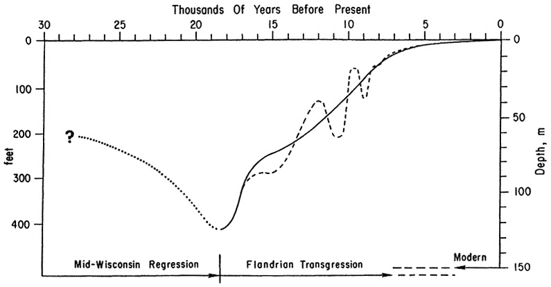
FIGURE 6.3 Late Quaternary fluctuations in sea level. Solid line is the generalized sea level curve (from Curray, 1965); dashed line is detailed curve (from Curray, 1960, 1961). Tree ring and Uranium/Thorium dates give greater age than the radiocarbon ages for these curves. Recent studies (Fairbanks, 1989; Bard, 1990) indicate the glacial maximum was 21,000 (230TH/234U) yearsBP with a sea level lowering of 121 ± 5 m.

budget of sediment concerns the sources, transport paths, and sinks of sediment in a littoral cell of coastal length 10 km to 100 km.
Nearshore Circulation
The interaction of surface waves moving toward the beach with other, trapped waves traveling along the shore produces alternate zones of high and low waves that determine the position of seaward-flowing rip currents. The rip currents are the seaward return flow for the longshore currents that flow parallel to the shore inside of the surf zone. The pattern that results from this flow takes the form of a horizontal eddy or cell, called the nearshore circulation cell (Inman et al., 1971, Figure 6.5). Nearshore circulation cells are ubiquitous wherever waves break along sandy beaches, and the intense, concentrated, seaward flow of their rip currents is the principal cause of drowning for inexperienced swimmers.
The nearshore circulation system produces a continuous interchange between the waters of the surf zone and the shelf, acting as a distributing mechanism for nutrients and as a dispersing mechanism for land runoff. Offshore water is transported into the surf zone by breaking waves, and particulate matter is filtered out on the sands of the beach face. Runoff from land and pollutants introduced into the surf zone are carried along the shore and mixed with the offshore waters by the seaward-flowing rip currents.
Two important mixing mechanisms are operative within the surf zone, each having distinctive length and time, scales determined by the intensity of the waves and the dimensions of the surf zone. The first is associated with the breaking wave and its bore, which produce rapid mixing in an onshore— offshore direction. This mixing gives coefficients of eddy diffusivity of the order of HbXb/T where Hb, and T are the breaker height and period of the waves and Xb is the width of the surf zone. The second process is advective and is associated with the longshore and rip current systems in the nearshore circulation cell. This longshore mixing mechanism gives an apparent eddy-mixing coefficient of the order of ![]() , where
, where ![]() is the longshore current velocity and Y is the longshore spacing between rip currents. Along ocean beaches HbXb/T and
is the longshore current velocity and Y is the longshore spacing between rip currents. Along ocean beaches HbXb/T and ![]() are about 10 m2/s and 100 m2/s respectively (Inman et al., 1971).
are about 10 m2/s and 100 m2/s respectively (Inman et al., 1971).
In addition, coastal circulation cells of large dimension are associated with the submarine canyons that cut across the shallow shelves of the world (Inman et al., 1976). The submarine canyons act as deep, narrow conduits connecting the shallow waters of the shelf with deeper water offshore. At times, strong seaward flows of water occur in the canyons, resembling large-scale rip currents. The canyon currents produce circulation cells having the dimensions of the shelf width and the spacing between the submarine canyons. These strong currents in submarine canyons seem to be caused by a unique combination of air-sea-land interactions consisting of: (1) a pile-up of water along the shoreline caused by strong onshore winds, (2) down-canyon pulses of water caused by the alternate high and low grouping (surf beat) of the incident waves, (3) a shelf seiche excited by the waves and by the pressure fluctuations in the wind field, and (4) the formation of continuous down-canyon

FIGURE 6.5 Schematic diagram of nearshore circulation cell consisting of onshore transport by the breaking wave, longshore transport in the surf zone and offshore transport by seaward flowing rip currents. Floatingand suspended material is deposited on the beach face by (a) wave runup and by (b) water percolating through thebeach sand.
currents as the accumulated weight of the sediment dislodged by the currents overcomes the density stratification of the deeper water.
Littoral Cells and the Budget of Sediment
A basic approach to understanding the relative importance of nearshore processes is to compare the sea's potential to erode the land with the land's potential to supply terrestrial erosion products. Such a comparison ultimately resolves itself in the balance between the budget of power in waves and currents and the budget of sediments available for transport. Of course, this balance varies widely from place to place and, even in the best studied areas, is but poorly understood. However, order of magnitude estimates can be attempted by considering the types of driving forces and the resulting sediment response in terms of the budget of sediment.
Waves move sand on, off, and along the shore. Once an equilibrium beach profile is established, the principal transport is along the coast. Theory and measurements show that the longshore transport rate of sand is proportional to the longshore stress-flux of the waves.1
The budget of sediment for a region is obtained by assessing the sedimentary contributions and losses to the region and their relation to the various sediment sources and transport mechanisms. Determination of the budget of sediment is not a simple matter, since it requires knowledge of the rates of erosion and deposition as well as understanding of the capacity of various transport agents. Studies of the budget of sediment show that coastal areas can be divided into a series of discrete sedimentation compartments called littoral cells. Each cell contains a complete cycle of littoral transportation and sedimentation including transport paths and sources and sinks of sediment. Littoral cells take a variety of forms, but there are two basic types. One is characteristic of collision coasts with submarine canyons, while the other is more typical of trailing-edge coasts where rivers empty into large estuaries as shown in Figure 6.6 (e.g., Inman and Brush, 1973; Inman and Dolan, 1989).
COASTAL ZONE SIMILARITIES AND DIFFERENCES
Mixing and longshore transport of nutrients, pollutants, and sediment occur in the nearshore circulation cells that are ubiquitous to all coastal zones. However, the dimensions and intensities of mixing and sediment transport are determined principally by wave climate. Higher waves produce wider surf zones and more intense mixing and transport. In general, windward coasts like the Pacific coast of the United States are subject to more consistent wave action with seasonal variations in intensity between summer and winter. In contrast, leeward coasts like the mid-Atlantic coast of the United States tend to have lower levels of average wave intensity but episodic interruptions by occasional severe tropical storms in summer and extratropical northeasters in winter (e.g., Inman and

Dolan, 1989). This results in more consistent mixing and transport processes on windward coasts and more episodic processes on leeward coasts.
The elements in the budget of sediment may be significantly different among the coastal types. These differences are associated with the steepness of the continental shelf and with the proximity of coastal mountains and streams that debouch directly into the sea. For example, rivers and streams are generally important sediment sources for collision coasts, whereas shelf and barrier roll-over are generally more important sources along trailing-edge coasts.
Collision Coasts
Collision coasts are erosional features characterized by narrow shelves and beaches backed by wave-cut seacliffs. Along these coasts with their precipitous shelves and submarine canyons, as in California, the principal sources of sediment for each littoral cell were the rivers, which periodically supplied large quantities of sandy material to the coast. The sand is transported along the coast by waves and currents until the river of sand is intercepted by a submarine canyon, which diverts and channels the flow of sand into the adjacent submarine basins and depressions (Figure 6.6a).
In the San Diego region of California, most coastal rivers have dams that trap and retain their sand supply. Studies show that in this area the yield of sediment from small streams and coastal blufflands has become a significant new source of sediment. It was also found that the cluster storms associated with the 1982/83 El Niño-Southern Oscillation phenomena produced beach disequilibrium that resulted in downwelling currents that carried sand onto the shelf (Inman and Masters, 1991). Normal wave action contains sand against the coast and, when sediment sources are available, results in accretion of the shorezone. High, total-energy wave events cause a loss of sand from the shorezone via downwelling currents that deposit sand on the shelf. The downwelled sediment is lost to the shorezone when deposited on a steep shelf such as that off Oceanside, California (Figure 6.6a), or it may be returned gradually from a more gently sloping shelf to the shorezone by wave action. The critical value of slope for onshore transport of sand varies with depth and wave climate but for depths of about 15 to 20 m is about 1.5 percent (1.0 degree).
In all cases where measurements were made just before and after the 1982/83 cluster storm events and the profiles were distant from structures, it was found that these storm events resulted in the lowest level of beach sand in the history of the observations. Using the profiles north of Oceanside Harbor, where conditions are closest to natural and unaffected by harbor effects, it was found that the 38 km of the central Oceanside subcell during 1982/1983 lost an unprecedented 33 million cubic meters of sand from the shorezone! Such a volume represents perhaps a 50-year supply of sediment to the shorezone under normal conditions (Inman and Masters, 1991).
California beaches are narrow and backed by eroding seacliffs that in many places have buildings on their brink. Since a wide beach is the best protection for eroding seacliffs, a major problem for these coasts is finding adequate sources of sand for beach nourishment.
Trailing-Edge and Marginal Sea Coasts
The mid-Atlantic coast of the United States, with its characteristic wide shelf bordered by coastal plains, is a typical trailing-edge coast. This low-lying barrier island coast has large estuaries occupying drowned river valleys. River sand is trapped in the estuaries and cannot reach the open coast. For these coasts, the sediment source is from beach erosion and shelf sediments deposited at a lower stand of the sea, whereas the sinks are sand deposits that tend to close and fill the estuaries (Figure 6.6b). Under the influence of a rise in relative sea level, the barriers are actively migrating landward in a rollover process in which the volume of beach face erosion is balanced by rates of overwash and fill from migrating inlets (e.g., Leatherman, 1979, 1981; Inman and Dolan, 1989). For these coasts, the combination of longshore transport and rollover processes leads to a distinctively braided form for the river of sand.
The Outer Banks of North Carolina, which include the Hatteras and Ocracoke Littoral Cells, extend for 320 kilometers and are the largest barrier island chain in the world. The Outer Banks are barrier islands separating Pamlico, Albemarle, and Currituck Sounds from the Atlantic Ocean. These barriers are transgressing landward, with average rates of shoreline recession of 1.4 m/yr. between False Cape and Cape Hatteras. Oregon Inlet, 63 km north of Cape Hatteras, is the only opening in the nearly 200 km between Cape Henry and Cape Hatteras that bounds the Hatteras Littoral Cell. Oregon Inlet is migrating south at an average rate of 23 m/yr. and landward at a rate of 5 m/yr. The net southerly longshore transport of sand in the vicinity of Oregon Inlet is between one-half million and one million m3/yr.
Averaged over the 160 km from False Cape to Cape Hatteras, sea-level rise accounts for 21 percent of the measured shoreline recession of 1.4 m/yr. Analysis of the budget of sediment indicates that the remaining erosion of 1.1 m/yr. is apportioned among overwash processes (31 percent), longshore transport out of the cell (17 percent), windblown sand transport (14 percent), inlet deposits (8 percent), and removal by dredging at Oregon Inlet (9 percent). This analysis indicates that the barrier system moves as a whole so that the sediment balance is relative to the moving shoreline (Lagrangian grid). Application of a continuity model to the budget suggests that, in places such as the linear shoals off False Cape, the barrier system is supplied with sand from the shelf.
Marginal sea coasts are characterized by more limited fetch and reduced wave energy. Accordingly, river deltas are more important sources of sediment than the area along the mid-Atlantic coast. Otherwise, barrier island rollover processes are quite similar. Along both coasts, offshore mining of sand may become an important source of beach nourishment.
Arctic Coasts
Tectonically, Arctic coasts are of the stable, trailing-edge type, with wide shelves backed by broad coastal plains built from fluvial and glacial deposits. Tidal amplitudes are small, and both ice and water motion are controlled predominantly by the wind. The Coriolis effect of east and west blowing winds results in water-level increases and decreases in excess of 1 meter.
At 70 degrees north latitude, the sun does not rise for seven weeks in winter and does not set for over ten weeks in summer. During the nine months of winter, the coast is frozen fast so that coastal processes are entirely cryogenic and dominated by ice-push phenomena. Wind stress and ocean currents buckle and fracture the frozen pack ice into extensive, grounded, nearshore, pressure-ridge systems known as stamukhi zones. The keels from the individual pressure ridges groove and rake the bottom, plowing sediment toward the outer barrier islands. During the three months of summer, the ice pack withdraws from the Beaufort Sea coast forming a 25-km to 50-km wide coastal waterway.
In contrast to winter, the summer processes are classical nearshore phenomena driven by waves and currents as shown by the beaches and barrier island chain in the vicinity of Prudhoe Bay (Figure 6.7). The sediment sources include river deltas, onshore ice-push across the shelf, and thaw-erosion of the low-lying permafrost seacliffs. Thaw-erosion rates of the shoreline are typically 5 to 10 m/yr. in arctic Russia and, over a 30-year period, averaged 7.5 m/yr. for a 23-km coastal segment of Alaska's Beaufort Sea coast (Reimnitz and Kempema, 1987).
The Flaxman Barrier Island chain extends westward from the delta of the Canning River. It appears to be composed of sand and gravel from the river, supplemented by ice-push sediments from the shelf (Figure 6.7). The prevailing easterly waves move sediment westward from one barrier island to the next. The channels between islands are maintained by setdown and setup currents associated with the Coriolis effect on the wind-driven coastal currents.
Coral Reef Coasts
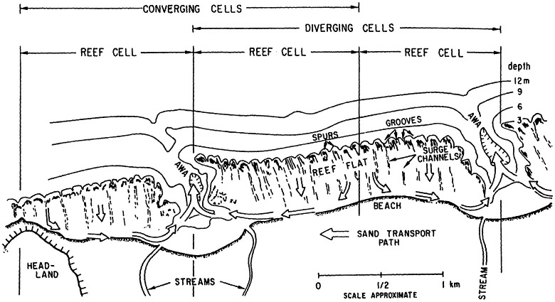
These coasts result from the biogenic activity of the fringing reefs, which, in turn, depend on special latitudinal conditions. The configuration of the reef platforms themselves incorporates the nearshore circulation cell into a unique littoral cell (Figure 6.8). The circulation of water and sediment is onshore over the reef and through the surge channels, along the beach toward the awas (return channels), and offshore out the awas. An awas is equivalent to a rip channel on the sandy beaches of other coasts (Inman et al., 1963).
In the unique situation of coral reef coasts, the corals, foraminifera, and calcareous algae are the sources of sediment. The overall health of the reef community determines the supply of beach material. Critical growth factors are light, ambient temperature, and nutrients. Turbidity and excessive nutrients are deleterious to the primary producers of carbonate sediments. On a healthy reef, grazing reef fishes bioerode the coral and calcareous algae and contribute sand to the transport pathway onto the beach.
The beach acts as a capacitor storing sediment transported onshore by the reef-moderated wave climate. It buffers the shoreline from storm waves, and releases sediment to the awas. In turn, the awas channel runoff and turbidity away from the reef flats and out into deep water. Where the reef is damaged by excessive terrigenous runoff, waste disposal, or overfishing, the beaches are imperiled.

REFERENCES
Bard, E. 1990. Calibration of the 14C timescale over the past 30,000 years using mass spectrometric U-Th ages from Barbados corals. Nature 345:405.
Barnett, T. P. 1984. The estimation of ''global'' sea level changes: a problem of uniqueness. Journal of Geophysical Research 89(C5):7980-88.
Barry, R. G. 1981. Trends in snow and ice research. Elsevier Oceanography Series, 62(46): 1139-44.
Curray, J. R. 1960. Sediments and History of Holocene Transgression, Continental Shelf, Northwest Gulf of Mexico. Pp. 221-266 in F. P. Shepard, F. B. Phleger, and Tj. H. van Angel, eds, Recent Sediments, Northwest Gulf of Mexico, 1951-1958. Tulsa, Oklahoma: American Association of Petroleum Geologists.
Curray, J. R. 1961. Late Quaternary sea level: a discussion. Geological Society of America Bulletin 72:1707-12.
Curray, J. R. 1965. Late Quaternary History; Continental Shelves of the United States, Pp. 623-35 in H.E. Wright, Jr. and D.G. Frey, eds., The Quaternary of the United States. Princeton, New Jersey: Princeton University Press.
Emery, K. O. 1980. Relative sea levels from tide-gauge records. National Academy of Sciences, Proceedings 77(12):6968-72.
Fairbanks, R. G. 1989. A 17,000-year glacio-eustatic sea level record. Nature 342:637-642.
Inman, D. L., and B. M. Brush. 1973. The coastal challenge. Science, 181:20-32.
Inman, D. L., and R. Dolan. 1989. The Outer Banks of North Carolina: Budget of sediment and inlet dynamics along a migrating barrier system. Journal of Coastal Research, 5(2):192-237.
Inman, D. L., and P. M. Masters. 1991. Budget of Sediment and Prediction of the Future State of the Coast. Chapter 9 in State of the Coast Report, San Diego Region Coast of California Storm and Tidal Waves Study, v.1. Final Report, September 1991. U.S. Army Corps of Engineers, Los Angeles District. Chapters 1-10, v. 2, Appen, A-I.
Inman, D. L., and C. E. Nordstrom. 1971. On the tectonic and morphologic classification of coasts, Journal of Geology 79(1):1-21.
Inman, D. L., W. R. Gayman, and D. C. Cox. 1963. Littoral sedimentary processes on Kauai, a sub-tropical high island. Pacific Science 17(1):106-130.
Inman, D. L., R. J. Tait, and C. E. Nordstrom. 1971. Mixing in the surf zone. Journal of Geophysical Research 76(15):3493-3514.
Inman, D. L., C. E. Nordstrom, and R. E. Flick. 1976. Currents in Submarine Canyons: An Air-Sea-Land Interaction. Pp. 275-310 in M. Van Dyke et al., eds., Annual Review of Fluid Mechanics, v. 8.
Leatherman, S. P., ed. 1979. Barrier Islands from the Gulf of St. Lawrence to the Gulf of Mexico. New York, New York: Academic Press.
Leatherman, S. P., ed. 1981. Overwash Processes. Benchmark Papers in Geology, v. 58. Stroudsburg, Pennsylvania: Hutchinson Ross Publishing Company.
National Research Council. 1987. Responding to Changes in Sea Level: Engineering Implications. Marine Board, National Research Council. Washington, D.C.: National Academy Press.
Peltier, W. R. 1986. Deglaciation-induced Vertical Motion of the North American Continent and Transient Lower Mantle Rheology. Journal of Geophysical Research 91(B9):9099-9123.
Reimnitz, E., and E. W. Kempema. 1987. Thirty-Four-Year Shoreface Evolution at a Rapidly Retreating Arctic Coastline. Pp. 161-164 in T. D. Hamilton and J. P. Galloway eds. Geologic Studies in Alaska by the U. S. Geological Survey During 1986: United States Geological Survey Circular 998.


