
C
Earth Science Division Missions
The committee requested data on several NASA Earth science missions. These included Landsat 8; the large strategic Earth Observing System (EOS) missions Terra, Aura, and Aqua; and the small mission Cloud-Aerosol Lidar and Infrared Pathfinder Satellite Observation (CALIPSO) and Gravity Recovery and Climate Experiment (GRACE). In addition, because these missions serve different purposes, it is difficult to make equal comparisons among them. In contrast, the Terra, Aqua, and Aura missions are more science-oriented in their goals, contributing to an understanding of Earth as a system.
EARTH OBSERVING SYSTEM LARGE STRATEGIC MISSIONS
In the late 1980s the Earth Observing System (EOS) was initiated to promote the concept of Earth system science supported by a large database of observations from satellites. The EOS concept spent many years in development and revision due to changes in the external science requirements, technological advancements, and budget environment. Officially initiated in FY1991, EOS was proposed as a series of spacecraft with an operational data collection period of 15 years. The platforms (at 10,000 to 11,000 kilograms each) were the largest ever flown, and they included a larger number of major instruments than previously hosted on a single spacecraft. After recommendations from the National Research Council and the Advisory Committee on the Future of the U.S. Space Program, and in recognition of the constrained fiscal environment, the program revised the payloads to make greater use of smaller platforms and shifted focus to concentrate on global climate change. As a result, the EOS mission set was divided into three large “flagship” missions supported by a state-of-the-art Data Information System (EOSDIS). Terra (initially EOS-AM1) was launched in 1999, followed by Aqua (initially EOS-PM1) in 2002, and Aura (initially CHEM) in 2004. These three missions are described in the following sections. Descriptions across the Terra, Aqua, and Aura entries are not necessarily equal; because Terra was the first in the series, there is more information available about that mission.
Terra
Terra was first of the EOS platforms built and is still operating. It is a large directed mission run out of NASA’s Goddard Space Flight Center (GSFC) and includes both facility and principal investigator (PI)-class instruments from three NASA centers, the National Center for Atmospheric Research (NCAR), and Japanese and Canadian
partners. With an orbit collecting daytime data in the AM (local time), Terra carries a suite of five complementary instruments:
- The Advanced Spaceborne Thermal Emission and Reflection Radiometer (ASTER), contributed by the Japanese Ministry of Economy, Trade, and Industry with a U.S.-led science team at the Jet Propulsion Laboratory (JPL), provides a unique benefit to Terra’s mission as a stereoscopic and high-resolution instrument required to measure and verify processes at fine spatial scales.
- Clouds and the Earth’s Radiant Energy System (CERES), originally a PI-led instrument out of Langley Research Center and now a facility-class instrument with similar sensors on several platforms (a copy of CERES is also flying on Aqua for the PM constellation), investigates the critical role clouds, aerosols, water vapor, and surface properties play in modulating the radiative energy flow within the Earth-atmosphere system.
- The Multi-Angle Imaging Spectroradiometer (MISR), a PI-led instrument out of JPL, characterizes physical structure from microscopic scales (aerosol particle sizes and shapes), to the landscape (ice and vegetation roughness and texture), to the mesoscale (cloud and plume heights and 3-D morphologies).
- The Moderate Resolution Imaging Spectroradiometer (MODIS), a facility-class instrument directed out of GSFC, acquires daily, global, and comprehensive measurements of a broad spectrum of atmospheric, oceanic, and land properties, improving and supplementing heritage measurements needed for processes and climate change studies (a copy of the MODIS instrument was also included on the Aqua platform as part of the PM formation).
- The Measurements of Pollution in the Troposphere (MOPITT) instrument, sponsored by the Canadian Space Agency with a science team at the University Corporation for Atmospheric Research (UCAR), retrieves carbon monoxide total column amounts as well as mixing ratios for seven pressure levels, and its gas correlation approach still produces the best data for studies of horizontal and vertical transport of this important trace gas.
As an individual mission, Terra did not incur serious cost overruns, despite its size. Terra’s Phase B/C/D costs were $1.3 billion, distributed over nearly a decade. Terra expended about 30 percent of its funding and schedule prior to the preliminary design review and experienced only limited cost growth (less than 10 percent). Terra launched successfully, and all five of its instruments operated nominally on-orbit and collected data in its prime mission period from December 1999 through 2004. Terra had its first extended mission review (Senior Review) in 2005. In extended mission phase, costs changed over time as some of the R&D associated with Terra was stripped from the mission core operating budget (prior to the 2007 Senior Review) and returned to the Earth Science Division general research pool supporting the broader community. By the 2007 Senior Review, the baseline operating budget for Terra was $38 million per year, distributed across three NASA centers and NCAR. Approximately 45 percent of those funds supported mission operations, mostly at NASA’s GSFC; 51 percent was allocated for science—primarily data analysis for PI instruments; and the remainder was split between Education and Public Outreach and management. By 2012 the baseline operating budget of Terra was reduced to $30.6 million, with cuts to both the data analysis and mission operations components. Since the Terra platform is aging, and all five instruments rely on mission operations, further reductions in the mission operations budget were becoming problematic. In 2012 the data analysis and mission operations funding split was even. In extended mission phase (FY2012), the Terra core mission funded approximately 155 whole-time equivalents per year, spread across three NASA Centers, NCAR, and academic institutions.
Aqua
Aqua, the second of the EOS missions, obtains information on Earth’s water cycle, including evaporation from the oceans, water vapor in the atmosphere, clouds, precipitation, soil moisture, sea ice, land ice, and snow cover on the land and ice. Aqua instruments also observe radiative energy fluxes, aerosols, vegetation cover on the land, phytoplankton and dissolved organic matter in the oceans, and temperatures of air, land, and water. Aqua carries
six instruments on board and, like Terra, has far exceeded its 6-year design life. Four of the Aqua instruments (Atmospheric Infrared Sounder [AIRS], Advanced Microwave Sounding Unit [AMSU], CERES, and MODIS) continue to operate well. The Advanced Microwave Scanning Radiometer (AMSR-E) for EOS was turned off in May 2016, and the Humidity Sounder for Brazil instrument failed in February 2003.
Aura
Aura, the third of the EOS missions, was designed to provide observations of atmospheric composition from the near surface through the troposphere, stratosphere, and mesosphere in order to address three broad areas of scientific inquiry related to atmospheric composition: (1) recovery of the stratospheric ozone layer as the human created ozone-depleting substances, including chlorofluorocarbons, decline as a result of the Montreal Protocol and its amendments; (2) emission, transport, and chemical transformation of tropospheric pollutants; and (3) the roles of constituents including aerosols, water vapor, and ozone in climate change. Aura carries four PI-led instruments. Two of Aura’s instruments (Microwave Limb Sounder [MLS] and Ozone Measuring Instrument [OMI]) are operating well, and the Tropospheric Emission Spectrometer (TES) is making limited observations at the time of this writing. The High Resolution Dynamics Limb Sounder (HIRDLS) was compromised at launch but obtained a 3-year data set for most of its constituents. HIRDLS ceased operations in 2008.
Scientific Productivity
Understanding Earth’s interdependent planetary-scale physical, biogeochemical, and climate systems requires that a broad set of measurements be made over long time periods—decadal or longer. At 17 years after the launch of the first EOS platform Terra, 15 years after Aqua, and over a decade since the launch of Aura, these large strategic EOS missions have had an enormous impact on the global Earth science community by providing over a decade of observations to the user community spanning all of NASA Earth Science Division’s designated science focus areas. Where relatively little data existed supporting Earth system science prior to EOS, there is now an extensive library of well-calibrated, validated data with the spatial and temporal acquisition characteristics required to make significant advances in Earth system science. The data generated by EOS have been widely used by the global scientific community to garner its own funding for support outside of NASA. In aggregate, by 2016, Terra, Aqua, and Aura produced over 33,000 publications in the refereed literature from over 100 countries, and downloads from the three missions are in the millions of data files per year.
Terra
As of the 2016 Senior Review, Terra produced 81 community-defined, well-calibrated, validated, temporally and geospatially overlapping Earth observations supporting studies in climate variability and change; atmospheric composition; the carbon cycle and ecosystems; the water and energy cycle; weather; Earth’s surface and interior; and applications in agriculture, disaster mitigation, and environmental studies. By the end of 2016 an estimated 14,400 publications using Terra data appeared in the refereed literature from 6,480 unique institutions in 167 countries, with more than 285,000 total citations. More than 3000 of these publications were from the People’s Republic of China, and over 3,800 were from the European Union.
Aqua
Aqua continues to produce 78 data products supporting almost all fields of Earth science, from trace gases and aerosols in the atmosphere, to chlorophyll in the oceans, to fires on land, to the global ice cover, and numerous other geophysical variables. Year-over-year increases in publications and data downloads attest to Aqua’s scientific productivity. By the end of 2016 an estimated 14,400 publications using Aqua data had appeared in the refereed literature. These are from 6,184 unique institutions in 143 countries, with more than 275,000 total citations. More than 3,000 of these publications were from the People’s Republic of China, and over 3,700 were from the Euro-
pean Union. There are many users of Aqua data beyond those supported by NASA-funded investigations (through either core mission or Research Opportunities in Space and Earth Sciences [ROSES]). Download statistics for 2016 show about 23,000 users in the United States, with 222,000 additional users worldwide. The committee did not obtain end-to-end mission cost data for Aqua. Ongoing funding for the extended mission in the 2015 Senior Review proposal cost about $28 million per year, with about 60 percent going to mission operations at GSFC and the remainder supporting science at JPL and GSFC. ROSES solicitations in 2014 (The Science of Terra and Aqua; Terra and Aqua—Algorithms—Existing Data Products) provided opportunities to the broad community interested in atmospheric composition research and also for targeted algorithm development.
Aura
Year-over-year increases in publications and data downloads attest to Aura’s scientific productivity. Operational uses of Aura data have grown rapidly during the past few years, especially for air quality applications. Aura completed prime mission (6-year operations) in July 2006 and has participated in Senior Review every 2 years, beginning in 2009. To date, the 2,330 Aura publications from 1,151 unique institutions in 71 countries have been cited more than 36,000 times.
There are many users of Aura data beyond those supported by NASA-funded investigations (through either core mission or ROSES). Download statistics for 2016 show about 4,000 users in the United States and 37,000 additional users worldwide. The committee did not obtain end-to-end mission cost data. Ongoing funding for the extended mission in the present Senior Review proposal costs about $25 million per year, with about half going to mission operations at GSFC and the remainder to the TES and MLS instruments teams at JPL and to the U.S. OMI science team. A recent ROSES solicitation included the Aura Science team along with the Atmospheric Composition Modeling and Analysis Program (ACMAP), providing a funding opportunity to the broad community interested in atmospheric composition research.
Impact on the Current and Future Health of the Relevant Scientific Communities
As described earlier, the EOS missions Terra, Aqua, and Aura provide the basic library of science data needed by the Earth science community. The importance of these data to the science community can be seen by the request in the 2007 decadal survey that these missions continue to operate for as long as possible. The EOS missions have contributed directly to the health of the science community as well. In 2001, Terra and the EOS missions were directly supporting 159 graduate students and 112 postdoctoral studies, and by 2005, EOS funded more than 770 science investigators in over 330 separate investigations.
Terra
Terra continues to have a robust and positive impact on the current and future health of the Earth science community. Breakthroughs in Earth science not only require specific measurements, but they also require a long baseline over time to detect trends and tease out links between processes. This was recognized in the 2007 decadal survey with the recommendation that “every effort should be made to extend the life of Terra, Aqua, Aura, the Solar Radiation and Climate Experiment (SORCE), and Glory to ensure the longest possible data records and to minimize or eliminate critical data gaps.” Because of the need for multidecadal records, data from Terra and the other EOS missions become more useful over time. This can be shown in the demand records for Terra data. In the first year of full operation (FY2001), the user community downloaded over 2.6 million Terra data files (not including metadata). This steadily grew, and in 2016 more than 284 million files were downloaded, with a mission total of over 1 billion data files being distributed to a growing international user community. In 2016 about half of the downloads were from foreign research organizations, with the rest divided up among U.S. federal, state, and local government agencies; businesses; and educational institutions. In Terra’s post-launch lifetime (up through FY2016), of the more than 1 billion data files downloaded, about 40 percent of those were downloaded by foreign institutions, another 40 percent roughly split equally between U.S. government agencies (federal, state,
local) and U.S. educational institutions, and about 8 percent by U.S. commercial enterprises (the remainder by users outside the tracked domains).
Terra’s impact is also documented in the broader research and applications communities. Besides downloads from archives, Terra data pass through 143 direct broadcast sites with over 1,000 users from these stations. More than 86 million Near Real Time files were delivered to the National Oceanic and Atmospheric Administration (NOAA), the U.S. Department of Defense, the U.S. Department of Agriculture, and other national operational users in FY2013 and FY2014. In 2014 the Office of Science and Technology Policy Committee on the Environment, Natural Resources, and Sustainability rated the Terra satellite among the top 10 of the nation’s high-impact observation systems for its impact on societal benefit areas, which include the following: agriculture and forestry, biodiversity, climate, disasters, ecosystems, energy and mineral resources, human health, ocean and coastal resources and ecosystems, space weather, transportation, water resources, weather, and reference measurements.
Aura
Aura data contribute substantially to several groups within the scientific community. Many MLS stratospheric measurements are unique (since the 2012 demise of European Envisat), and MLS ozone profiles (along with other MLS measurements of other constituents) are necessary to identify and quantify ozone increases that are expected as ozone depleting substances decrease, as mandated by the Montreal Protocol and its amendments. MLS and OMI together provide information needed to detect recovery of the Antarctic ozone hole. These data are critical input to the quadrennial World Meteorological Organization ozone assessments required by the Montreal Protocol. Measurements of ozone and water vapor in the upper troposphere and lower stratosphere are necessary for understanding their contributions to climate change and feedbacks in the climate system. TES data provide insight into the long-range transport of pollutants and the impact of such pollution on air quality worldwide. Health community use of Aura data has grown dramatically since 2015. Applications include exposure to ultraviolet radiation (controlled by stratospheric ozone levels) and exposure to nitrogen dioxide (an industrial pollutant and component of automobile exhaust). Data from Aura and various A-Train sensors are in use to quantify interactions between composition and clouds, chemical compounds and aerosols, upper tropospheric composition and convective processes, and other topics too numerous to list here.
Contributions to Development and Demonstration of Technology Applicable to Future Missions
The large size and cross-disciplinary nature of the EOS missions served as a test bed for demonstrating and testing different technologies and approaches for meeting Earth science goals. As a result many of the instruments on the EOS platforms were state of the art in the development phase and became predecessors for follow-on missions. With 15 instruments on three platforms, describing each one here is not practical. Instead, in this section the committee cites some examples, which are not meant to be ranked or exhaustive.
Terra and Aqua
Terra and Aqua carry versions of two instruments deemed to be of such primary importance that it was desirable to have data collected twice during daylight hours (locally)—CERES and MODIS.
The CERES instrument was a significant advancement over its predecessor, the Earth Radiation Budget Experiment. Advances in the time response of thermistor bolometers increased spatial resolution by a factor of 2 and increased instrument lifetime by a factor of 3 (and counting). The CERES ground calibration facility enabled a factor of 2 improvement in absolute calibration accuracy. The CERES instrument’s innovative azimuthal axis drive system provided the ability to rotate in azimuth as it scans in elevation, which greatly improved the angular sampling needed to convert measured radiances to radiative fluxes. The azimuth axis drive system also enabled CERES to be placed in a programmable mode for intercalibration with other instruments and sample optimization to support field campaigns. CERES demonstrated how multiple instruments (CERES, MODIS, geostationary imagers) can be used synergistically to provide a diurnally complete representation of Earth’s radiation budget
from the top-of-atmosphere to the surface with unprecedented accuracy. The many advances in CERES technology and data processing, and the important lessons learned during over 17 years in orbit, are now being incorporated in the successor to CERES, the Radiation Budget Instrument (RBI).
The closest predecessor to MODIS was the Advanced Very High Resolution Radiometer (AVHRR) that operated on NOAA polar platforms for more than two decades. MODIS improved on the spectral sampling and signal-to-noise ratio over the heritage AVHRR. The prelaunch and onboard calibration of MODIS vastly improved that of AVHRR, which did not have a means of monitoring its absolute calibration. Aqua MODIS is now used by the Global Space-Based Inter-Calibration System as its standard for intercalibration of operational geostationary and low-earth-orbit imagers. MODIS was designed with what is still the most comprehensive onboard calibration systems, including a Spectralon-based solar diffuser approach with a solar diffuser stability monitor (SDSM), a new V-groove blackbody, lamp-based source coupled with a spherical integrator, and spectroradiometric calibration assembly (SRCA). The many advances in MODIS technology and data processing have impacted the design and operation of the Visible Infrared Imaging Radiometer Suite (VIIRS); Operational Land Imager; Thermal Infrared Sensor (TIRS); Climate Absolute Radiance and Refractivity Observatory (CLARREO); Plankton, Aerosol, Cloud, and Ocean Ecosystem; and Advanced Baseline Imager (ABI). The overall success of MODIS led to its design being the basis for the VIIRS sensor on the NOAA polar orbiting platforms. The SRCA gave confidence that new designs of spectral filters were not susceptible to degradation on orbit, meaning that future sensors would not need to include an SRCA and could rely on simplified prelaunch characterization leading to shorter development times, lower sensor weight, and associated cost savings. The success of the design of the MODIS onboard blackbody was implemented for TIRS, simplifying the design and shortening the development time of the onboard calibrator for that mission. The SDSM provided a clear understanding of how the MODIS solar diffuser changed on orbit and how processing of the SDSM data led to a model of the behavior of Spectralon as a function of solar illumination. The Spectralon solar diffuser demonstrated that this material was suitable for use in both operational and research sensors and what manufacturing processes are needed to mitigate changes on orbit. The OLI project used the SDSM data to define an on-orbit operational approach with three diffusers, rather than requiring an SDSM. The CLARREO project used the MODIS results to verify that a diffuser approach would not satisfy requirements leading to a lower-weight, solar irradiance ratio approach for on-orbit calibration. The VIIRS mission required a monitoring system similar to SDSM to achieve their requirements and relied on the SDSM design to shorten development times and define prelaunch characterization. The science from MODIS defined the spectral bands needed for the operational VIIRS and ABI missions. The use of the moon and terrestrial desert scenes for monitoring sensor health has led to the definition of protocols and methods for multiple other missions, allowing the moon and deserts to be lower cost options for on-orbit radiometric calibration. Similarly, the algorithms to process MODIS data to retrieve aerosol properties, locate fires, assess snow/ice, track vegetation changes, and retrieve cloud parameters have been used for the VIIRS project and are being considered for ABI, leading to high-quality data products while leveraging the development time and costs through the Terra and Aqua missions.
Terra: Advanced Spaceborne Thermal Emission and Reflection Radiometer
Composed of three separate instrument subsystems (the visible and near infrared [VNIR], the shortwave infrared [SWIR], and the thermal infrared [TIR]), the Advanced Spaceborne Thermal Emission and Reflection Radiometer (ASTER) pushed the state of the art in multispectral imaging, especially in space-based multispectral stereoscopic imaging and high-resolution multispectral remote sensing in SWIR and TIR. ASTER is the only instrument with high-resolution (90 meters) multispectral TIR imaging bands, and it remains an important contributor to the development of future TIR missions. Throughout its lifetime, researchers demonstrated how the unique information from the TIR benefits many disciplines. Several initiatives have built on ASTER’s technology, data processing, and acquisition strategy. The ECOsystem Spaceborne Thermal Radiometer Experiment on Space Station (ECOSTRESS), a multispectral TIR instrument heavily reliant on ASTER’s heritage, is scheduled to go on the International Space Station in 2018. The Hyper Spectral InfraRed Imager, a decadal survey Tier-2 mission, is planned as the natural follow-on to ASTER.
Terra: Multi-Angle Imaging Spectroradiometer
The Multi-Angle Imaging Spectroradiometer (MISR) demonstrated the use of miniaturized focal plane “butcher block” pushbroom stripe filters; automated photogrammetric image geolocation and co-registration data processing algorithms; and advanced multiangle, multispectral data processing algorithms to improve the ability to measure and map the abundance of different types of airborne particulates. These technologies were subsequently used by the Multi-Angle Imager for Aerosols to investigate the human health impacts of airborne particulate pollution, which was selected in 2016 under the Earth Venture Instruments-3 program and will fly as a hosted payload on a commercial satellite platform. MISR technology was also used to demonstrate a novel, automated multiangle stereophotogrammetric remote sensing and data processing approach for the measurement of accurate, height-resolved atmospheric winds. When combined with recent advances in complementary metal-oxide-semiconductor array detectors flown commercially on SkySat-1 and SkySat-2, this approach will enable the design of a low-cost, compact cloud-tracking wind sensor that can be used to provide global winds from a future low-Earth orbit satellite constellation.
Terra: Measurements of Pollution in the Troposphere
The Measurements of Pollution in the Troposphere (MOPITT) instrument makes use of the principle of correlation spectroscopy whereby a cell of the gas to be measured is used as an optical filter in the infrared to measure the signal from the same gas in the atmosphere. Using this approach, MOPITT first demonstrated the ability of satellites to continuously monitor global sources and transport of carbon monoxide in the troposphere. Retrieval techniques, model evaluation, and data assimilation for remotely sensed trace gas data have all been greatly enhanced through experience with MOPITT data. MOPITT was also the first satellite instrument to demonstrate the use of radiance observations from separate wavelength regions simultaneously for the determination of both near-surface and free troposphere trace gas concentrations. These advances have been applied to later instruments such as AIRS on Aqua, the Scanning Imaging Absorption Spectrometer for Atmospheric Chartography on Envisat, TES on Aura, Infrared Atmospheric Sounding Interferometer on MetOp, and future instruments such as the upcoming Tropospheric Monitoring Instrument on Sentinel-5p.
Aura
Aura provided the opportunity for advancements in technology over predecessor missions. The Aura MLS obtains a more comprehensive suite of constituents with improved vertical range and resolution compared to the MLS instrument that was flown on the Upper Atmosphere Research Satellite (UARS) and included a novel terahertz radiometer to obtain a near daily global 5-year data set for the hydroxyl radical. TES obtained the first simultaneous profile information for tropospheric ozone and precursor gases. HIRDLS obtained profiles of temperature and ozone with about 0.5-km vertical resolution, the best ever achieved with remote sensing. The OMI observed total column ozone and near-surface pollutants, including nitrogen dioxide and sulfur dioxide, with unprecedented horizontal resolution (13 km × 25 km) with a wide swath, obtaining daily global coverage for the first few years of operations and within 2 days at present. Improved algorithms make it possible to estimate emissions of nitrogen dioxide and sulfur dioxide directly from OMI data. The Aura team has combined information from several sensors to improve vertical resolution or horizontal coverage. This includes using more than one Aura sensor (e.g., MLS/TES carbon monoxide, OMI/TES ozone) or including an A-Train sensor (OMI/[Aqua]AIRS ozone).
Conclusions: Terra, Aqua, and Aura
Terra (and the other EOS missions) clearly demonstrates that large strategic missions can successfully serve to focus and galvanize the science community around new and emerging scientific perspectives. As the first of the EOS missions, Terra was referred to as a “flagship mission” in Earth science because it was the first in a series demonstrating the value of a “great observatory” approach for collecting the vast amount of data required to advance Earth system science. At the time of its conception, there was a sense of urgency in the community to
begin collecting the vast amount of daily, global observations needed to test and advance the state-of-the-art physical, biogeochemical, and climate models and better understand the magnitude and direction of critical processes and their linkages. Terra and the other EOS missions did this very well. As large missions, they not only provided the basic data to advance Earth system science in its early phase, but they also continue to provide needed baseline data and the continuity required by the science community to fully realize science goals. Terra also sustained the community by providing a test bed for technological development and financial support with durations that provide stability for learning and career development. The mission funds for Terra (and other EOS missions) were widely distributed across sectors (government, commercial, and educational) and supported personnel in science, engineering, and management of a duration (decadal time line) sufficient to establish and maintain a national capability. Educational time lines, for example, are getting longer, and the average Ph.D. in the sciences takes over 6 years of postgraduate work.1 The Terra mission alone supported the education of a generation of scientists and engineers for nearly 10 years in formulation and another 4 in prime mission, contributing significantly to making the United States a leader in Earth observation science and technology. The large strategic nature of Terra also enabled international cooperation and fostered U.S. leadership. Funding and schedule duration for a large mission better facilitates international collaboration through the availability of personnel and cross-administration stability. Terra (and Aqua and Aura) had broad and deep national and international support including international partners. EOS stimulated the development and formation of numerous Earth system science research centers and enterprises worldwide, and the instruments flown on these missions are emulated by other countries. Data from the EOS series of missions are used globally by many thousands of scientific researchers, investors, policy makers, and commercial enterprises. Also important in the success of Terra and the other EOS missions is the EOSDIS. EOSDIS is the world’s largest Earth satellite data distribution system and has been responsible for making data from NASA’s EOS fleet available to scientists and users worldwide. EOSDIS was built within the concept of large strategic missions and has subsequently benefited missions of all sizes.
Earth science missions have a unique position within NASA, responding to both immediate and long-term societal needs. The current Earth science decadal survey will define balance for the recommended program in the future.
CLOUD-AEROSOL LIDAR AND INFRARED PATHFINDER SATELLITE OBSERVATION
The Cloud-Aerosol Lidar and Infrared Pathfinder Satellite Observation (CALIPSO) mission is an international partnership between NASA and the French Space Agency (CNES). Launched on April 28, 2006, CALIPSO measurements fill a crucial, well-recognized need for high-resolution atmospheric profiling and are proving essential in reducing the uncertainties that limit our understanding of the role of aerosols and clouds in the global climate system. The 3-year nominal mission was completed in April 2009. It was subsequently extended during Earth Science Division Senior Reviews in 2009, 2011, 2013, and 2015. CNES participated in and concurred with all mission extension decisions.
The CALIPSO instrument suite consists of a two-wavelength polarization-sensitive lidar, a three-channel infrared imaging radiometer, and a single-channel wide field-of-view camera.
Since launch, CALIPSO has been acquiring near-continuous observations of the vertical distributions of clouds and aerosols in Earth’s atmosphere. The new information provided by these unique measurements is substantially advancing human understanding of the spatial structures and optical properties of clouds and aerosols, and markedly improving the performance of a variety of models ranging from regional chemical transport and weather forecast models to global circulation models used for climate prediction.
CALIPSO orbits in formation with five other spacecraft in the A-Train satellite constellation and provides complementary, near-simultaneous observations with CloudSat and the many passive sensors in the A-Train.
___________________
1 National Center for Science and Engineering Statistics Directorate for Social, Behavioral, and Economic Sciences, National Science Foundation, December 2015 NSF 16-300, https://www.nsf.gov/statistics/2016/nsf16300/digest/nsf16300.pdf.
Scientific Productivity
CALIPSO observations and data products are widely used throughout the international scientific community. CALIPSO measurements, accumulated over 10+ years of near-continuous global observations, provide new and valuable insights into the distributions and properties of aerosols and clouds and the processes that control them. CALIPSO observations are greatly improving our understanding of radiative forcings and feedbacks, allowing for more powerful evaluations of cloud and aerosol parameterizations in a variety of models, and providing comprehensive validation of other remote sensing techniques. The CALIPSO observational record now captures significant interannual modes of variability, which influence climate on seasonal to decadal scales.
CALIPSO data are used in increasingly sophisticated ways, and there is increasing use of merged data products that combine CALIPSO and CloudSat measurements with A-Train passive sensor data, such as 2B-FLXHR-Lidar and C3M. CALIPSO observations have been widely adopted by the modeling community, particularly by the Cloud Feedback Model Intercomparison Project. CALIPSO observations and data products produced by the CALIPSO project are highly valued by the international scientific community and are used in more than 1,800 publications.2 (See Figures C.1 and C.2.)
___________________
2 A complete bibliography of peer-reviewed CALIPSO publications can be found at NASA, “Bibliographies,” https://www.calipso.larc.nasa.gov/resources/bibliographies.php.
Benefits to Operational Agencies
CALIPSO profile observations provide a valuable source of information for operational forecast centers and application-focused researchers. Expedited products, with a latency of 24 hours or less, are produced for users with time-sensitive applications. Standard products have a latency of several weeks and can be used for off-line evaluations. Additionally, CALIPSO provides a near-real-time expedited aerosol product specifically designed for assimilation by operational centers. This mission demonstrates that science missions can have value to operating agencies that have to make predictions about weather events.
Conclusions
CALIPSO is an example of a mission that both is international and serves an operational purpose. It demonstrates that traditional metrics of evaluating the productivity of a mission, such as published papers, may not capture the full value of a mission. How can the value of a mission that produces benefits to international partners as much as the United States be judged? How can the value of a mission that may provide timely data required for forecasting and decision making be compared to the slower pace, and different impacts, of scientific publications? CALIPSO demonstrates that missions have to be evaluated on individual merit in addition to more traditional metrics such as publications produced over a longer period of time.
GRAVITY RECOVERY AND CLIMATE EXPERIMENT
The Gravity Recovery and Climate Experiment (GRACE) is a collaborative NASA and German Aerospace Agency (DLR) mission launched on March 17, 2002, as the first of the Earth System Science Pathfinder missions. The objective of the GRACE mission is to characterize the spatial and temporal variations in Earth’s mass transport, through accurate measurements of its gravity field. The GRACE mission completed its baseline 5-year mission in 2007 and has received four additional 2-year mission extensions. The GRACE extended mission provides a continuous, multiyear sequence of measurements that characterize the seasonal cycle of mass transport between the oceans, land, and atmosphere; observes its interannual variability; and measures the decadal and secular trends in mass transport.
GRACE provides new insights into the evolution of Earth’s climate system by making mass flux measurements at spatial resolution scales from approximately 200 km to global and timescales from 10 days through the interannual and secular. The GRACE measurements are recognized as a key component of NASA’s capability to observe the Earth system interactions. The mission is characterized by the following: (1) the unique GRACE ability to observe coupled processes within Earth’s land, ocean, atmosphere, and cryosphere subsystems; (2) the consequent multidisciplinary viewpoint of the users of GRACE data products; and (3) a cost-effective mission implementation achieved through cooperation between NASA and DLR.
Examples of new measurements uniquely determined or enabled by GRACE include the following:
- Mass change in the polar ice sheets, continental glaciers, and the permafrost;
- Mass contribution to sea-level rise, the separation of ocean thermal expansion (heat content) from mass changes, and the estimation of deep (>2,000 m) ocean heat content;
- Global measurements of the hydrological cycle including seasonal and interannual river basin water storage changes, human influences on regional water storage changes, large-scale evapotranspiration, land-ocean mass exchange, and regional aquifer changes;
- Changes in the deep ocean currents and mass and energy transport, inter-ocean-basin mass variations, and regional oceanic processes;
- Large-scale post-glacial rebound; and
- Episodic mass displacements and mantle flow associated with large earthquakes.
The twin GRACE satellites have collected science data continuously since commissioning in April 2002. Currently, the satellites are in near-circular, polar orbits at ≈337-km altitude and maintain along-track separation of ≈220 ± 50 km. After 15 years in orbit, the science instrumentation has reduced performance. The declining capability of the power system has forced changes in the science operations since 2011. Near the epochs of sun passage through the orbit plane every 161 days, both the accelerometer and the K-band ranging instruments are turned off, leading to delivery of 8 to 10 monthly gravity field products during recent calendar years.
Scientific Productivity
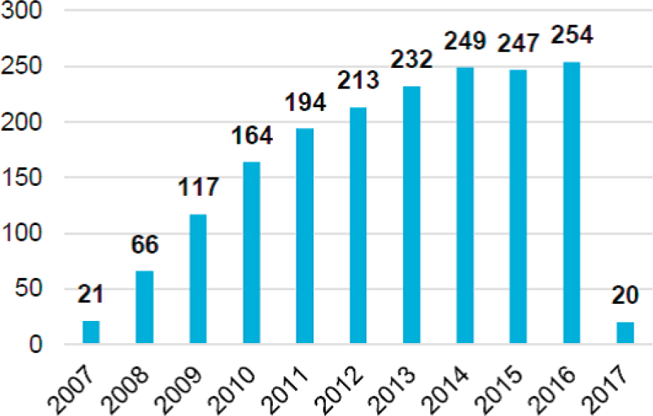
There have been more than 2,000 publications based on the GRACE data during its 15 years on orbit, with an average of 200 publications during the past 6 years. Figure C.3 shows the number of publications per year since the launch of the mission.
Impact on the Current and Future Health of the Relevant Scientific Communities
Since launch in 2002 the GRACE mission has provided unprecedented knowledge about the interactions of the Earth system. Using global measurements of gravity as a sensor of mass change, GRACE has detected and quantified changes in all major components of the water cycle. In particular, the mission provides fundamental insights into polar ice sheet melt and its contribution to sea level change, ocean mass changes as they relate to ocean circulation, sea level variations and ocean heat content, and detailed views of the world’s surface and under-
ground water resources. Based on the significant advances in both the measurement capability and the interpretative framework during the mission’s 15-year life span, GRACE data are now an essential asset for a number of hazard assessment efforts. With the development of the capability to reduce the product latency, it is now an essential input to operational drought forecasting within the framework of the U.S. National Drought Monitor. In 2016 several international efforts were founded on the GRACE gravity data for disaster prevention and forecasting (the multination European Gravity Service for Improved Emergency Management). In addition to drought and water resource assessment, GRACE also provides crucial information for flood prediction, as shown in recent FY2016 publications. Overall, global measurements of regional water storage are capabilities that are uniquely provided by GRACE, and these measurements will be a unique resource for future water management. In a significant accomplishment GRACE data have been ingested by a Land Data Assimilation Model to demonstrate significant improvements in the spatial and temporal resolution of the Total Water Storage Products and to provide a separation of the columnar total water storage into the surface, soil, and groundwater components. The near-real-time provision of these products can support forecast and planning activities related to societal water use for agricultural and consumption purposes. This broad range of applications clearly illustrates the multidisciplinary nature of the GRACE mission and its ability to aggregate scientists from different disciplines in Earth sciences.
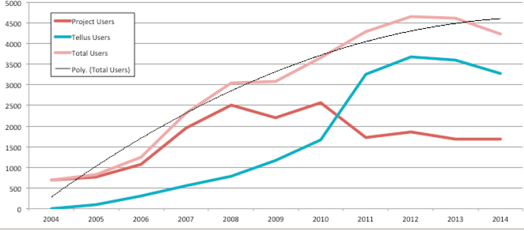
The current number of annual users who extract data from the GRACE data system exceeds 4,500. Figure C.4 shows the evolution of the number of users of GRACE data/products since the beginning of the mission.
A GRACE Follow-on (GRACE-FO) mission is scheduled for launch in 2018. The two GRACE-FO satellites will use the same kind of microwave ranging system as GRACE and so can expect to achieve a similar level of precision. But they will also test an experimental instrument using lasers instead of microwaves, which promises to make the measurement of their separation distance at least 20 times more precise. GRACE-FO is a partnership between NASA and the German Research Centre for Geosciences (GFZ).
Conclusions
Precision gravity measurements by GRACE have enabled global perspectives on large land and ice shifts that would not otherwise have been possible.
Such measurements have provided quantitative data on the loss of mass in the Greenland ice sheet from 2002 to 2016, which has, in turn produced a global rise in sea level at a rate of 0.8 mm per year. In general, GRACE has revealed new details on the ebb and flow of water basin content, for example, in the Amazon, and how Earth’s net water cycle impacts sea level height on a global scale. GRACE also reveals changes in the solid Earth, notably in the mantle and lithosphere during earthquakes and in the isostatic adjustments as land masses rebound following the melting, and subsequent removal via runoff, of ice sheets and glaciers.3 These measurements will be extended to even higher precision using new technology to be implemented on the GRACE-FO mission.
___________________
3 NASA Jet Propulsion Laboratory, “Applications—Overview,” https://grace.jpl.nasa.gov/applications/overview/#solid-earth; NASA Jet Propulsion Laboratory, “Studying Earth’s Gravity,” https://grace.jpl.nasa.gov.


