
CHAPTER 1
Introduction
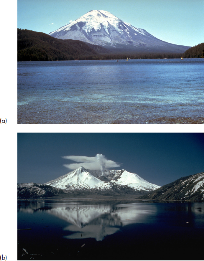
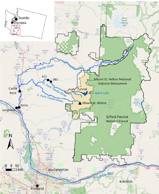
The explosive 1980 eruption of Mount St. Helens in southwest Washington State destroyed the summit of the volcano, resulting in a massive debris avalanche. Debris avalanche material and large volumes of pyroclastic flow deposits were directed north of Mount St. Helens into the North Fork Toutle River valley (see Figures 1.1 and 1.2). Lahars (mudflows consisting primarily of volcanic materials) transported volumes of sediment large enough to cause radical changes to the long-term hydrology of the Toutle River watershed and that of the Cowlitz River into which the Toutle flows. Enough sediment was transported to the Columbia River that 4 miles (6.4 km) of shipping channels approximately 50 miles (80 km) downstream of Portland, Oregon, had to be dredged to allow normal shipping. The headwater of the Toutle River—Spirit Lake, located approximately 4 miles (6.4 km) north of Mount St. Helens—was dammed by debris avalanche deposits with thicknesses in some areas of greater than 400 feet (120 m). That debris blockage remains today as do concerns regarding its possible failure. Failure could result in the release of 314,000 acre-feet (390 million m3) of water and 2.4 billion cubic yards (1.8 billion m3) of sediment into the Toutle, Cowlitz, and Columbia Rivers (Swift and Kresch, 1983), directly impacting 50,000 people living in communities along the Toutle and Cowlitz Rivers.
The Spirit Lake that existed prior to 1980 was essentially eradicated by the landslide and pyroclastic debris from the eruption. The Spirit Lake that replaced it resides in the same basin, but it is larger in aerial extent, greater in volume, and higher in elevation. Whereas the earlier Spirit Lake drained by gravity flow through a natural surface channel to the North Fork Toutle River, the Spirit Lake that replaced it has no natural drainage. Left as it was
following the eruption, the lake would slowly fill and eventually overtop and erode its blockage. The fear is that breaching could lead to a catastrophic flood and associated lahars when a large fraction of the lake volume escapes down the North Fork Toutle, inundating everything in its path. The size and other characteristics of this catastrophic flood were predicted using engineering models in the aftermath of the eruption (Swift and Kresch, 1983), but there is uncertainty associated with those models. Loss of life among residents of communities along the Toutle and Cowlitz Rivers is likely given a worst-case flooding scenario and the number of people residing in flood-prone regions. Impacts of a catastrophic breach, discussed in the literature and described in Chapter 4, would be felt beyond the immediate region; a major highway (Interstate 5) and rail transportation corridor that parallels the Cowlitz River and connects Portland, Oregon, and Seattle, Washington, could be buried. Such catastrophic events are not unprecedented in the area, as geologic evidence indicates breakouts of an ancestral Spirit Lake with lahars of similar magnitudes (Scott, 1988a).
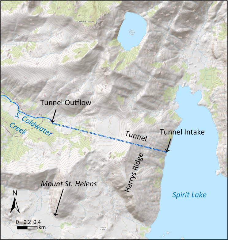
Alternatives for draining the new Spirit Lake and controlling the lake’s water surface elevation were considered (USACE, 1984a), and the decision was ultimately made to construct an 8,600-foot-long (2,600-m), 11-foot-diameter (3.4-m) gravity-fed tunnel to drain water west into South Coldwater Creek and eventually into the North Fork Toutle River (see Figure 1.3). The tunnel was completed in 1985 (details were summarized by Grant et al., 2016a) and is now the sole egress of water from the lake and the sole means of controlling water levels in the lake. It has worked effectively, but the tunnel has required major repairs to prevent its failure at different times during its operation. A 2014 inspection of the tunnel revealed that it was again at risk of failure (Britton et al., 2016a). Whereas failure of the tunnel does not imply immediate failure of the debris blockage, it raises the risk of such failure until the outlet is restored or some other means of controlling water levels is created. Repairs of the tunnel create additional risk because drainage through the tunnel must be stopped to allow access to the tunnel. Prolonged repairs, especially during the region’s rainy season, leave the lake vulnerable to rising water levels.
Members of the U.S. Congress, aware of the increased hazard of a Spirit Lake breakout following the 2014 tunnel inspection, requested immediate corrective action (see Appendix D). The U.S. Forest Service (USFS), in cooperation with U.S. Army Corps of Engineers (USACE) and the U.S. Geological Survey (USGS), were requested to “review and analyze the array of options for a long-term plan that removes the threat of catastrophic failure of the tunnel and takes the unstable nature of the surface geology into account” (Beutler et al., 2015). The three agencies embarked on coordinated and simultaneous efforts to identify long-term management alternatives. This National Academies of Sciences, Engineering, and Medicine (National Academies) report is a response to a request from the USFS to develop a framework for technical decision making regarding management not just of water levels in Spirit Lake but also of coordinated management of water and sediment transport in the entire Spirit Lake and Toutle River system. Managed as a system, decisions could address the risk of catastrophic flooding associated both with failure of the debris blockage and with the management of sediment still transported through the river system today. These sediments result in a river hydrology that is drastically different from that before the 1980 eruption, making the population of the region more vulnerable to chronic flooding associated with annual rainfall events.
In addition to the tunnel, the USACE constructed and manages a sediment retention structure (SRS) on the North Fork Toutle River approximately 8 miles (13 km) downstream of Spirit Lake (see Figure 1.2 for location). Levees near towns have also been modified in response to the increased risk of chronic flooding. The SRS traps sediment before it is transported to the Toutle and Cowlitz Rivers. It therefore limits the amount of dredging necessary to decrease the hazards associated with chronic annual flooding and to keep channels open on the lower Cowlitz River. Sediments trapped above the SRS have changed the upstream landscape, affecting the ecological, cultural, and economic health of the area. As presently configured, the SRS is reaching capacity and decisions must soon be made regarding the future management of the structure and the sedi-
ments behind it. The decision framework presented in this report would allow determination of the objectives, alternatives, consequences, and trade-offs associated with the technical management of the river system as a whole. The framework also supports consideration of the regional economic, cultural, and societal priorities as they relate to the various technical decisions. Sediment and water transport for the region to date has not been a coordinated effort among those with management responsibility in the region, and management decisions have not included much consideration of socioeconomic priorities of interested and affected parties.
THE CHARGE TO THE COMMITTEE
Under the sponsorship of the USFS, the National Academies convened an ad hoc committee of experts to review existing information regarding the Spirit Lake and Toutle River system and to develop a framework for decision making related to management of water and sediment transport. The statement of task provided to the committee is found in Box 1.1. The committee was also asked to identify alternatives for future management and to describe gaps in information needed to inform those decisions. The committee explored the state of the technical knowledge, the concerns of interested and affected parties, and the roles and interests of the USFS, the USACE, the USGS, and other entities with responsibilities for managing water and related land resources in the Spirit Lake and Toutle River region. The report focuses on management in the context of the post-eruption conditions and possible future volcanic and other geologic activity. This report does not discuss issues associated with emergency management nor does it provide details of management alternatives already being considered (available in multiple reports issued by the USACE). Neither does this report recommend specific management actions. Instead, it identifies the types of information necessary to characterize the problems to be addressed, to formulate alternatives to address those problems, and to evaluate and compare those alternatives. The report also offers findings regarding organizational considerations that may factor into the use of the framework.
The USFS intends to use the framework recommended by the National Academies to collaboratively examine the viability of various management alternatives and make informed decisions, first about management of water levels in Spirit Lake—which is within their jurisdiction—and then about the larger system.
COMMITTEE MEMBERSHIP
Members of the ad hoc committee that conducted the study and prepared this report were nominated by their peers and selected by the National Academies based on their professional qualifications and lack of undo bias or conflict of interest. The committee includes researchers and practitioners with expertise in civil, geotechnical, hydraulic, tunnel, and earthquake engineering; waterway infrastructure protection, hydrology, and water resource management; fluvial geomorphology, landscape ecology, and volcanology; and natural resource economics, decision analysis, and disaster resilience. Brief biographies of the committee members can be found in Appendix A.
INSTITUTIONAL SETTING
The USFS has responsibility for management of lands and water within the footprint of the Gifford Pinchot National Forest and the Mount St. Helens National Volcanic Monument (the Monument). Mount St. Helens, Spirit Lake, and the Spirit Lake tunnel are located on USFS land. The broad language that created the Monument instructs the USFS as follows:
The Secretary shall manage the Monument to protect the geologic, ecologic, and cultural resources, in accordance with the provisions of this Act allowing geologic forces and ecological succession to continue substantially unimpeded. (P.L. 97-243, Sec 4. (b)(1))1
A memorandum of understanding between the USFS and the USACE, however, makes the USACE responsible for annual inspections and routine operation and maintenance of the Spirit Lake tunnel, to be performed at the expense of the USFS. Repairs beyond the routine require the USFS to seek additional funding from Congress and for the work to be contracted to the USACE.
The USFS has no authority over land use, flood and sediment control infrastructure investment or management, or fishery and other wildlife
___________________
management decisions outside of USFS lands; nor does it have control of the federal and state funding streams that support all of those. The USFS does recognize, however, that management decisions regarding any of these can have short- and long-term impacts on the whole region. Decisions made about control of water levels at Spirit Lake, for example, can have consequences for sediment management downstream, while decisions made regarding management of the SRS can have implications on the ecology of the region up- and downstream. Any decision made in the region may impact the responsibilities and concerns of federal, state, and local agencies; Native American Tribes; private-sector organizations; and individual citizens and citizen groups. The responsibilities, missions, and interests of those groups sometimes overlap and even conflict. No single entity exists to coordinate their activities. Chapter 3 provides more information about the institutional setting of the region and how that setting affects land management.
NATURAL HAZARDS AFFECTING REGIONAL MANAGEMENT
The Toutle and Cowlitz River basins are similar to other coastal drainages in the Pacific Northwest. They contain bucolic forests and wildlife and a community that, through the years, has made its livelihood from natural resources and recreation. Further downstream the drainages enter the urbanized communities of Kelso and Longview that depend on the Toutle and Cowlitz Rivers for navigation, manufacturing, and other economic activities. These river basins are dominated by the volcanic landscape and activity of Mount St. Helens, however, and also are subject to other natural hazards (e.g., seismic, meteoric, landslide, consequences of fire).
Indigenous peoples have occupied the region around Mount St. Helens for 6,000 years and consider eruption as the mountain’s natural state. Stories of the Cowlitz Indian Tribe are deeply entwined with the landscape. Tribal elders advise people to adopt a philosophy of “living with the mountain” (personal communication with the committee, N. Reynolds, August 1, 2016). Management of the region needs to be mindful of the reality that
Mount St. Helens continues to be active, and volcanic events can be expected to change the landscape. The 1980 eruption of Mount St. Helens resulted in a reshaped landscape, a new regional hydrology, and new hazards for the region’s populations, the risks associated with which can never be completely eliminated. These are now the “new normal” to which the population needs to adjust. Future events may include another catastrophic eruption of the magnitude of the 1980 event, although the probability of such an event in the near future is less likely than that of lahars and smaller eruptions. No level of mitigation or repair can ever result in the elimination of all natural hazard risk. Zero risk is not an option unless residents choose to move elsewhere (and face the risks of living in that location).
The region also is commonly subject, in both human and geologic timescales, to seismic events associated with regional fault zones. Shaking from seismic activity could result in, for example, lahars and mudflows that might increase the sediment loads in the river basins or affect the stability of the debris blockage. The region is subject to annual rainfall typical of the Pacific Northwest, and meteorological events called atmospheric rivers (known colloquially as the “Pineapple Express”) or rain-on-snow events may have major impacts on flooding and sediment transport on the Toutle and Cowlitz Rivers. Chapter 4 describes natural hazards of the region.
A catastrophic threat other than another large-scale eruption of Mount St. Helens hangs over the Toutle and Cowlitz River basins in the form of a major earthquake on the Cascadia Subduction Zone (i.e., of magnitude [M] greater than 9.0). A mega earthquake on the subduction zone would likely be a disaster, with local consequences of similar magnitude to or greater than the 1980 eruption of Mount St. Helens depending on where the earthquake originates. The specific consequences of a mega earthquake on the Spirit Lake and Toutle River region have not been quantified by investigators.
THE CURRENT DECISION LANDSCAPE
Immediately following the eruption, two principal considerations influenced management decisions: the costs of possible management actions
and their impacts on the safety of downstream communities (USACE, 1984a). The tunnel, the SRS, community and federal flood risk management programs (e.g., land use controls, levees, flood insurance), and USACE dredging contracts are measures put in place to manage catastrophic and chronic flood hazards. Many of the original decisions around these measures, however, were made under emergency conditions and were based on limited physical characterization of the region. These measures have been generally adequate in temporarily managing routine flooding and sediment transport given the stresses experienced since the last major eruption, but the measures have also had ecological and socioeconomic consequences. Management decisions resulted in hindering sediment in a mid-reach of the river system (i.e., behind the SRS) in a nonequilibrium position, forestalling the river reaching a natural equilibrium, changing the landscape even further, and potentially creating a different set of anthropogenic risks that need to be assessed and monitored. Moreover, management of the different elements of the Spirit Lake and Toutle River system have not been adaptable or flexible to changing conditions, nor has it encouraged monitoring those conditions to deepen an understanding of how the system might be better managed in the long term.
Input from interested and affected parties other than those with direct management authority has not been incorporated into many of the management decisions made in the region. As a result, there is expressed dissatisfaction with and lack of trust in the management of the various control elements. For instance, interested and affected parties in the region have called for river restoration measures that would enhance recreational benefits and restore natural fish runs and wildlife habitat and populations. Concerns have also been raised about social and economic disruption resulting from increases in routine flooding along the Toutle and Cowlitz Rivers; the environmental and cultural effects of the sediments captured behind the SRS; flooding caused by continued channel infilling; and potential volcanic or seismic activity that may destabilize large quantities of water and sediment behind the SRS.
The USACE anticipates that further major repairs of the tunnel will be necessary (Britton et al., 2016a). The need for a long-term strategy to
manage water levels at Spirit Lake prompted the USFS to request this National Academies report. The immediate decision to be made is whether to continue to repair the current tunnel to keep it operational or to abandon the current tunnel and replace it with a different engineering measure to control Spirit Lake water levels. A different measure might be one that was previously identified (see USACE, 1984a) or it might be some other as-yet unidentified measure. There is opportunity now to better constrain uncertainties associated with various management alternatives. These management alternatives could be studied in ways that allow for a better understanding of the relatonships between objectives and alternatives—for example, through use of an objectives hierarchy (Keeney, 1996; see also the section on objective hierarchies in Chapter 7). This results from more adequate characterization and modeling using improved tools and methods and informed by advances in science. The consequences of those alternatives may also be better anticipated and compared with a complete range of management objectives, including those of regional stakeholders. More informed decisions may be reached that will better serve the region.
DEFINING TERMS IN THE STATEMENT OF TASK
Several terms in the committee’s statement of task (see Box 1.1) may be defined differently by interested and affected parties given their various perspectives. The terms “framework for technical decision making,” “region,” “system,” “stakeholder,” and “long-term” are defined in the next sections as they are used in this report. The exercise of defining these terms helped the committee bound its task and facilitated committee deliberations.
Framework for Technical Decision Making
In this report, a technical decision is that which requires the expertise of trained individuals to analyze available data and inform appropriate management. The expertise may be related, for example, to engineering issues; to the physical, biological, or ecological sciences; to the social sciences (e.g., economic, sociological); or to some combination of these. A
decision framework is a procedural tool to guide users through a decision process. It supports a future-oriented strategy that leads decision makers through assessment of decision objectives, alternatives and their respective consequences, and, ultimately, to a management decision that is mutually supportable by all involved by the decision process. A decision framework helps decision makers define what is to be decided and the processes for getting to decisions. This includes processes for determining who is to be involved and how as well as for gathering input to identify and compare decision objectives and alternatives in light of available information, constraints, and uncertainties. A decision framework guides how input can be used to create and eliminate alternatives in the search for a set of mutually acceptable solutions. The process should help participants reach and justify decisions and clarify the bases of any disagreements to inform future decisions.
The decision framework described in Chapters 6 through 8 is participatory in nature so that stakeholder priorities will both inform and be informed by the different analytical processes and information gathering. The framework is applicable to any technical management decision made for the region under any specific agency’s jurisdiction. The intent of the committee, however, is that the framework be used to coordinate management for the region as a whole.
The “System” and “Region” Under Consideration
A system is a set of interacting or interdependent processes or elements. A region is the geographic area in which the elements of the system are located. There are numerous agencies in the region with often overlapping or conflicting authorities. Their respective missions can be relatively limited in scope, resulting in the ad hoc management of infrastructural elements at Spirit Lake, the North Fork Toutle and Toutle Rivers, and downstream into the Cowlitz River. As already stated, however, few if any elements of the system are truly independent of other elements. The effects of management decisions on one element of the system need to be considered in light of the consequences of those decisions on the system as a whole. Ideally,
management for all elements of the system will be simultaneous and made with the understanding that sediment transport in the Toutle River will be continuous for the foreseeable future.
For the purpose of discussion around developing a decision framework, the committee defined the system as the drainage of Spirit Lake to the Toutle River and to the Toutle River’s confluence with the Cowlitz River. The committee considers the effects of these water bodies to the extent that they derive from or are otherwise related to the drainage of Spirit Lake and the management of sediment transport within the drainage. During future decision making, the system may need to be defined more broadly or narrowly depending on the impacts of concern. With respect to fish migration, for instance, the planning area could extend to the Columbia River or beyond. With respect to flood risk reduction, the planning area may need to extend to the confluence of the Cowlitz and Columbia Rivers. With respect to sediment control, the planning area might be limited mostly to the North Fork Toutle River, or it may need to include the South Fork Toutle River and other tributaries. The extent of the system and region for any set of management decisions depends on the consequences of concern and varies depending on the decisions to be made.
Stakeholders (Interested and Affected Parties)
A stakeholder is typically defined as a person with a particular interest in some decision. In this report, the committee assumes a broader view of those who have an interest in a decision. Traditionally, stakeholders of decisions made about managing water levels in Spirit Lake would include those people in harm’s way, including those whose homes, businesses, or livelihoods might be destroyed or damaged by a catastrophic flood. This report also includes as stakeholders those whose culture or quality of life are affected directly or indirectly. Importantly, stakeholders are those individuals and entities responsible for management of the region; federal, state, and local agencies, then, are considered to be among the region’s stakeholders.
To distinguish the committee’s broader usage from the more traditional definition, the committee adopts the term “interested and affected parties”
in this report. Such parties include federal, tribal, state, and local entities with responsibilities in the region, land and business owners, nongovernmental organizations (e.g., environmental or recreational organizations), residents, and any individual or group with interests about public safety and health, emergency management, wildlife recovery and ecological health, economic development (e.g., forestry, those dependent on navigable channels, ecotourism), cultural preservation, recreation opportunities, and any number of other issues.
The committee attempted to hear from a wide array of interested and affected parties to determine the range of concerns and how they might affect the choice of a decision framework. The groups with whom the committee attempted to communicate during the conduct of this study are listed in Table 1.1. The table does not represent a complete list or scientific sampling of interested and affected parties, but rather lists groups that were readily identified by the committee. Invitations were extended to representatives of all these groups to participate in the committee’s meetings and provide input into the committee process.
Chapter 3 includes more discussion about interested and affected parties. Many of these groups sent representatives to the committee’s open session meetings or provided written input. A number of independent citizens also participated in discussions. Chapter 6 describes how interested and affected parties are identified and how interactions with them can be organized to be most useful.
Long-Term Management
The committee was tasked with developing a framework suitable for decisions made for “long-term management.” When asked, however, the USFS could not quantify “long term.” Formulating, evaluating, and comparing possible alternatives to address problems requires the selection of an appropriate planning period. A common choice among engineers is 50 years, reflecting the economic life of many kinds of investments and the ability to predict with any certainty ecological and socioeconomic conditions in the planning area (if that effort is made). In the case of long-lived infra-
TABLE 1.1 Interested and Affected Organizations Contacted During the Study
| Type of Organization | Organization Name |
|---|---|
| Federal Agencies | U.S. Army Corps of Engineers; U.S. Forest Service; U.S. Geological Survey |
| Tribal Agencies | Cowlitz Indian Tribe; Yakama Nation |
| State Agencies | Washington Department of Archeology and Historical Preservation; Washington Department of Ecology; Washington Department of Fish and Wildlife; Washington Department of Natural Resources; Washington Department of Transportation; Washington State Governor’s Office for Regulatory Innovation and Assistance; Washington State Parks and Recreation Commission |
| Local Agencies | Cowlitz County (Board of Commissioners, Emergency Management, Tourism); Port of Longview |
| Nongovernmental Organizations | Audubon Society (Washington and Willapa Hills); Cascade Forest Conservancy (formerly the Gifford Pinchot Task Force); Conservation Alliance; Conservation Northwest; Cowlitz Game and Anglers; Mount St. Helens Institute; Sierra Club; Toutle Valley Community Association; Washington Environmental Council; Washington Trails Association |
| Private Sector | Axiall Corporation; BNSF Railway; Castle Rock Chamber of Commerce; Chilton Logging; Cowlitz County Tourism; Drew’s Grocery; Ecopark Resort; Kapstone Paper; Kelso-Longview Chamber of Commerce; Washington Forest Product Association; Weyerhaeuser Company |
structure, a longer period (e.g., 100 years or longer) might be selected, although projections of relevant variables become increasingly uncertain for longer periods. On the other hand, the likelihood of various disruptive events (earthquakes, volcanic eruptions) within the planning period suggest a shorter period (e.g., 25 years).
The committee asked individuals who attended the committee’s open session meetings what they interpreted “long-term management” to mean. Representatives of the Cowlitz Indian Tribe often consider the management time frames imposed on natural systems by non–Native Americans as unrealistically short. Management time frames, according to the Cowlitz Indian Tribe ecologist Nathan Reynolds, should be informed by the amount of time human beings can assist nature to restore itself and flush sediments through the system—perhaps 175 years (personal communication to the committee, August 1, 2016). Steve Ogden, a forester for the Washington Department of Natural Resources (WADNR), thinks about planning horizons in terms of the amount of time for a forest to regenerate—approximately 50 to 100 years. He also suggests that management factor intergenerational equity into decisions, reflecting on how decisions today will affect our children and grandchildren (personal communication to the committee, August 1, 2016). Dave Howe of the Washington Department of Fish and Wildlife (WDFW) described the need for making planning horizons long enough to accommodate the reestablishment of dynamic riparian landscapes, but he also mentioned his concern about overengineering infrastructure that will subsequently be destroyed in a catastrophic event (personal communication to the committee, August 1, 2016). Planning horizons need to be chosen with both the understanding that longer time frames increase the likelihood of destructive events (and thus the loss of capital investment) occurring within the planning period and the understanding that longer time frames are necessary for ecosystem regeneration. Many of the interested and affected parties who provided input to the committee expressed concern over what they perceived to be the overly short management time frames for structures like the SRS (discussed further in Chapters 5 and 6).
Rather than provide a definition of long term, this report lays out how those participating in the decision process could choose an appropriate time horizon based on the priorities and objectives of interested and affected parties participating in the decision process. Chapter 6 includes further discussion of considerations for choosing a planning horizon.
COMMITTEE APPROACH TO ITS TASK
There are two distinct but related components of the committee’s task. One is related to the technical aspects of the problems at hand. Geologic, hydrologic, ecological, and meteorological processes, in conjunction with the engineering infrastructure in place, control the flow of water and sediment in the river system. These engineering projects are expected to reduce the risk of property damage and loss of life from flooding and mudflows in the short term. The physical processes and the structures interact in ways not completely understood, and the return of vegetation and wildlife to the plains of debris avalanche deposits are being studied for the first time in modern history.
The second component of the task includes sociopolitical considerations. A large number of interested and affected individuals and groups at local, state, regional, and national levels of society—influenced by the wide array of safety, economic, environmental, and cultural priorities held by those groups—make decisions about the physical system more complex. Conflicting goals of those charged with management of different parts of the physical and social landscapes are not often addressed. The framework for decision making recommended by the committee assumes active collaboration and engagement among interested and affected parties so that both physical and sociopolitical considerations can be addressed fairly.
During the conduct of its study, the committee found either that few new data have been collected and analyzed since initial hazard characterization efforts immediately following the 1980 eruption, or that such data and analyses could not be provided to the committee. There are multiple reasons for the latter: in some cases, a loss of institutional memory associated with turnover in agency leadership means that knowledge of
the characterization efforts has been lost; in other cases, information was withheld from the committee to avoid the need for public disclosure.2 The committee complied with its task by reviewing available information and identifying the types of information and analyses necessary to quantify the viability of the various management options. It will be up to the decision makers to obtain either existing or new information for their own analyses.
Information Gathering
The conclusions and recommendations in this report are based on the assessment of publicly available information and data. The USFS, in collaboration with the USACE and the USGS, provided a compendium of characterization and management data related to the Spirit Lake and Toutle River system. All three agencies provided information upon request during conduct of the study. An important work by USFS and USGS researchers was published late during the conduct of this National Academies study (Grant et al., 2016a). That work provides an excellent description of the physical context associated with decisions related to management of Spirit Lake water levels. The present report includes frequent references to discussions provided by Grant and others (2016a).
Any presentations or discussions with the committee by agencies or members of the public occurred during open sessions of committee meetings. Members of the public were welcomed and could participate either in person or remotely. Meetings were announced widely and in advance through communications mechanisms of both the National Academies and the USFS. Members of the public were also invited to provide input to the committee via links through websites established for that purpose. The committee held three meetings that included information gathering sessions. These were held in Kelso, Washington, a major population center
___________________
2 The National Academies of Sciences, Engineering, and Medicine comply with the Federal Advisory Committee Act (P.L. 92-463) which requires that all information provided to the committee during the conduct of a study be made available to the public. The public can request any of this information through the National Academies’ Public Access Records Office: http://www8.nationalacademies.org/cp/ManageRequest.aspx?key=49785.
in the region affected by conditions and sediments in the Toutle River. Agendas for all open session meetings are provided in Appendix B, which also include the names of individuals who were explicitly invited to make presentations or participate in panel discussions.
The first meeting, held June 21-23, 2016, focused on the state of scientific and technical knowledge about Mount St. Helens, Spirit Lake and its outflow tunnel, and the SRS. Presentations were made by scientists, engineers, and managers from the USGS, the USACE, and the USFS, with substantial time dedicated to questions from and discussions with the public. The meeting was organized to orient the committee to its task. One day of the meeting included visits to points of interest in the Toutle River valley and the Monument, including the Johnston Ridge Observatory, the Spirit Lake tunnel outlet, the SRS, and one of the levees that was improved following the eruption. Scientific and technical experts from the USFS, the USACE, the USGS, and Centralia College in Chehalis, Washington, guided the visits. Members of the public were invited to register to participate in the site visits on a limited basis.3
The committee’s second meeting, held August 1-3, 2016, focused largely on obtaining input from nonfederal interested and affected parties. Panels were organized representing (1) local and regional interests, including the Cowlitz County Board of Commissioners, the Port of Longview, the Cowlitz County Department of Emergency Management, and local business interests; (2) nonprofit organizations, including the Cowlitz Game and Anglers Club, the Mount St. Helens Institute, and the Toutle Valley Community Association; and (3) state and tribal natural resource management agencies, including the Natural Resources Department of the Cowlitz Indian Tribe, the WDFW, and the WADNR. A study committee member moderated each of the panel discussions. Panelists were provided with sets of questions in advance of the meeting and asked to respond verbally and in turn to those questions during the meeting. The questions were intended to identify panelist perceptions and major concerns regarding management of Spirit Lake and Toutle River issues. There was ample
___________________
3 Public participation in the site visits was limited for logistical and safety reasons.
opportunity for discussion between panelists and committee members as well as with observers of the proceedings. Additional panel discussions were organized with sets of USACE experts to discuss lessons learned from a recent interagency potential failure modes analysis of the Spirit Lake blockage and long-term sediment management in the region. To allow broader participation by the public, a town hall–style meeting was held in the evening.
The third meeting, held October 31, 2016, included a presentation and discussion with USFS and USGS experts regarding the recently published report on the geologic, geomorphologic, and hydrological concepts that underlie currently considered options for management of Spirit Lake water levels (Grant et al., 2016a). The committee organized another panel discussion with USACE technical staff to hear their response to the report by Grant and colleagues (2016a).
In addition to this input received from the agencies, experts, and other interested and affected parties, the committee relied on published literature and their own expertise and experience to inform their findings and support the conclusions and recommendations in this report.
REPORT ORGANIZATION
This report provides a technical foundation and organization process for decision making that draws on lessons from risk management decision processes established elsewhere. It is assumed that decisions made using the framework will be grounded in reliable data; that those data will be used in analytically rigorous models of the larger system and system interconnections; that the concerns of the multiple interested and affected parties will be recognized; and that preferred actions will be selected in consideration of the sources and levels of available funding. To that end, the report is organized to first provide a general overview of the physical setting, infrastructure, and implications for assessing risk and long-term management (Chapter 2); the institutional setting of the region, including the land ownership and management setting and other interested and affected parties (Chapter 3); the natural hazards in the region and the adequacy of risk
analyses conducted to date (Chapter 4); and the engineering landscape, including descriptions of risks associated with engineered controls and structural alternatives for engineering management (Chapter 5). Thereafter, the report provides a detailed discussion of the recommended decision framework (Chapters 6-8) and a summary of next steps that could be taken by those with management authority in the region to implement the recommendations found within this report (Chapter 9). Whereas Chapters 6-8 satisfy the requirement in the statement of task to recommend a decision framework, the committee identifies good practices throughout the report. The syntheses of the key requirements for implementing the decision framework are labeled explicitly as “recommendations” and are found in bold typeface in Chapters 3 through 6 and have also been compiled in the report summary. These tend to be general in nature, but they do not reflect common management practices in the region.
This page intentionally left blank.


