
CHAPTER 2
Regional Setting
The regional conditions that contribute to risk must be taken into account in decisions regarding long-term management of the Spirit Lake and Toutle River system. This chapter discusses various aspects of the regional setting that provide the context for decision making: the physical geography of the region; the geologic setting; the groundwater hydrology; the ecological setting; the socio-demographic and economic setting; and other important features within the region, including the debris blockage and built-environment elements such as the drainage tunnel from Spirit Lake, the sediment retention structure (SRS), and levees. This chapter provides only a general overview of the technical information available regarding the region that informed the committee’s deliberation of its statement of task (see Box 1.1). More information is available in materials published by the U.S. Army Corps of Engineers (USACE), the U.S. Geological Survey (USGS), and the U.S. Forest Service (USFS). Greater detail regarding the institutional setting is provided in Chapter 3, and details about hazards and engineering controls to minimize risk is provided in Chapters 4 and 5. Alternatives for controlling water levels in Spirit Lake are also discussed in Chapter 5. A major point emphasized in the concluding section of this chapter is that regional characteristics must not be considered in isolation but instead must be analyzed as interrelated elements within a broader system.
PHYSICAL GEOGRAPHY
Mount St. Helens is located in southwestern Washington, roughly 50 miles (80 km) northeast of Portland, Oregon, and 100 miles (160 km) south of Seattle, Washington. The region that includes Mount St. Helens and the
Toutle River drainage is a volcanic and glaciated terrain that drains into a small number of high-elevation lakes, including Spirit Lake, Coldwater Lake, and Castle Lake, and then into the north and south forks of the Toutle River. Downstream sediment movement through the North Fork Toutle River drainage is affected by the SRS, which was constructed by the USACE in 1989 to limit downstream sediment deposition in areas where it had the potential to increase flood risk and affect shipping. From the SRS, water and untrapped sentiments are transported into the main channel of the Toutle (approximately 33 miles [53 km] downstream of Spirit Lake), then on to the Cowlitz River (another 15 miles [24 km]), and eventually into the Columbia River downstream of Portland (roughly an additional 20 miles [32 km]).
The lateral blast of the 1980 eruption of Mount St. Helens scorched 230 square miles (600 km2) of forest, predominantly to the north of the mountain (see Figure 2.1), and it greatly affected forests, fish and wildlife,
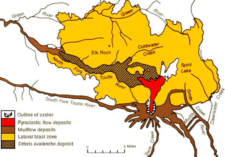
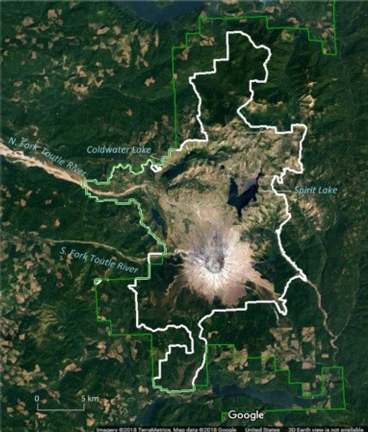
and waters in the blast vicinity. In 1982 the U.S. government created the Mount St. Helens National Volcanic Monument (the Monument), which included much of this devastated land, for purposes of research, recreation, and education (see Figure 2.2). Within the Monument, which is a part of
Gifford Pinchot National Forest and is managed by the USFS, the natural setting of the mountain and its surrounding lands is left free to respond in its own way to the historic disturbance. More detail about management of the Monument is provided in Chapter 3.
Streams that originate on Mount St. Helens are fed by rain and snowmelt and enter three main river systems: the Toutle River to the north and northwest, the Kalama River to the west, and the Lewis River to the south and east. The Monument itself contains Spirit, Coldwater, and Castle Lakes, as well as the headwaters of the North Fork and South Fork Toutle Rivers. It does not include the lower reaches of the North Fork Toutle River, within which the SRS was constructed. Because the current outflow pathway for Spirit Lake is through the North Fork Toutle River system (which was the river most heavily impacted by the eruption), discussions in this report will emphasize that drainage system, but there are management issues related to the decision framework that may involve other river systems in the region.
Spirit Lake
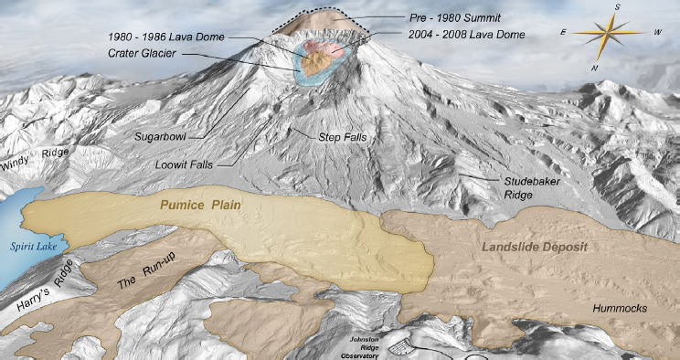
Spirit Lake is an intermittent (from a geologic perspective) subalpine lake that currently contains approximately 275,000 acre-feet (339 million m3) of water. Before the 1980 eruption, the lake had a surface area of 1.9 square miles (5 km2) and a surface elevation of 3,140 feet (975 m) (Meyer and Carpenter, 1983). It was connected to the North Fork Toutle River through a natural outlet stabilized by gravel and boulders, which allowed outflow from the lake to rise and fall within a narrow range in response to seasonal rainfall and snowmelt runoff. The debris avalanche associated with the collapse of the volcanic edifice during the 1980 eruption partly flowed into the lake, and thick avalanche deposits buried the original lake outlet. No rivers flow into the lake, which is fed solely by rainfall and snowmelt. A fraction of water stored in the lake is now released into South Coldwater Creek via the Spirit Lake tunnel (see Figure 1.3 for location of the tunnel). The surface elevation of Spirit Lake now fluctuates seasonally between approximately 3,438 and 3,449 feet (1,048-1,051 m), with a gradual rise in the past decade. Storage as a function of lake elevation is shown in Table 2.1.
TABLE 2.1 Spirit Lake Stage-Storage Relationship
| Elevation (ft., NGVD29) | Storage (ac-ft.)a | Storage (ac-ft.)b |
|---|---|---|
| 3,437.1 | 205,500 | Values from the 1984 Design Memorandum were used for these values. |
| 3,438.2 | 208,300 | |
| 3,440.0 | 213,000 | |
| 3,441.1 | 215,900 | |
| 3,442.6 | 219,920 | |
| 3,443.1 | 221,180 | |
| 3,444.1 | 223,700 | |
| 3,445.0 | 226,000 | |
| 3,446.3 | 229,470 | |
| 3,448.8 | 235,900 | |
| 3,450.0 | 239,300c | 238,840 |
| 3,451.8 | 244,400 | 243,627c |
| 3,454.8 | 252,900 | 251,606c |
| 3,455.1 | 253,481c | 252,138 |
| 3,460.0 | 268,000 | 265,782 |
| 3,470.0 | 297,100 | 294,016 |
aThese values are from the 1984 Design Memorandum.
bThese values were updated using 2009 LIDAR (Light Detection and Ranging) data. The full elevation storage curve was not updated, just values above 3,445.
cThese values were estimated using linear interpolation with immediate elevation-storage information.
NOTE: All information appears exactly as provided by the USACE.
SOURCE: USACE, 2016a.
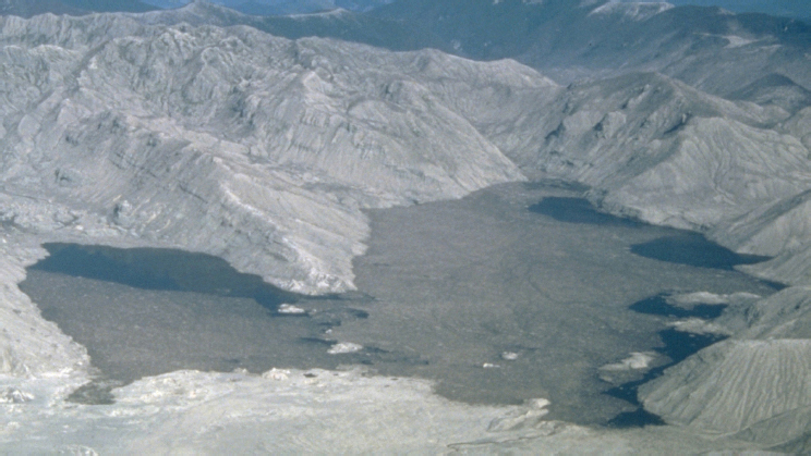
The northward-directed blast and debris avalanche from the 1980 eruption temporarily displaced all the preexisting Spirit Lake from its bed (see Figure 2.3). The debris avalanche deposited roughly 350,000 acre-feet (432 million m3) of debris into Spirit Lake, raising the surface elevation of the lake by about 200 feet (61 m). As a result, the bottom of the lake was filled with avalanche deposits and therefore elevated approximately 400 feet (122 m) above that of the lake prior to the eruption. The bottom elevation of the new Spirit Lake is well above the contact of the debris deposit and
competent bedrock. The lake is assumed to be capable of breaching that blockage at elevation 3,475 feet (1,059 m), which is the interface between the pyroclastic flow and the finer, more erodible ash above (described later in this chapter).
The North Fork Toutle River to the Sediment Retention Structure
Prior to the 1980 eruption of Mount St. Helens, the North Fork Toutle River originated at Spirit Lake, where the debris blockage currently exists. Discharge from Spirit Lake now reaches the North Fork Toutle River via the Spirit Lake tunnel and South Coldwater Creek (see Figures 1.2 and 1.3 for locations). Eventually those waters reach the SRS and the Toutle River (see Figure 1.2). USGS National Water Information System data1 indicate that lake outflow supplies 300-400 cubic feet per second to the North Fork
___________________
1 These data are available at https://maps.waterdata.usgs.gov/mapper/index.html.
Toutle River (depending on the condition of the outlet tunnel), which is approximately one-third of the average river flow at the SRS but only 3-4% of the mean annual flood at that location. Because it emanates from Spirit Lake and traverses Coldwater Lake on its way to the Toutle River, the lake outflow contributes no sediment until it flows across the sediment plain behind the SRS, picking up small amounts of sediment, approximately in proportion to its flow contribution. The rest of the upper Toutle River valley, outside of the Spirit Lake basin, is the source of approximately half of the mean annual flood discharge and of all the sediment arriving at the SRS and being transported to the lower Cowlitz River.
The Toutle and Cowlitz Rivers Downstream of the SRS
The north and south forks of the Toutle River converge approximately 13 miles (21 km) downstream of the SRS to become the upper Toutle River. Much of the coarser, sand-sized particles in the deposits are captured at the SRS, but when sediments reached high enough levels at the SRS and converted to run-of-river functioning in 1999 (before the spillway was raised by the USACE), more of this coarse fraction passed downstream into the Toutle River (USACE, 2011). The Toutle continues to flow westerly approximately 17 miles (27 km) until its confluence with the Cowlitz River, near the town of Castle Rock. From there, water flows to the Columbia River at Longview and Kelso. Flood levees have been constructed along these reaches to reduce flood risk to the communities of Kid Valley, Castle Rock, Lexington, Kelso, and Longview and the unincorporated communities between them. Sediments transported downriver and deposited along these lower reaches decrease the discharge capacity of the lower reaches, making the flood levee system less effective and requiring levee strengthening and river dredging. Sediment deposition also interferes with navigation on the lower Cowlitz River, similarly requiring channel dredging.
The Columbia River
The Cowlitz River flows into the Columbia River at near Kelso and Longview, approximately 65 miles (105 km) upstream of the Pacific Ocean. The Columbia River is navigable by means of a deepwater channel to Portland. Following the 1980 eruption of Mount St. Helens, a sufficient volume of sediment was deposited in the Columbia at Longview to prohibit oceangoing vessels from transiting. This impediment was remediated by dredging the Columbia River channel; but, in principle, a similar blockage could occur again following another major eruption given the infilling of the Mount St. Helens crater with successive dome building events (see Chapter 4). Without such an eruption, the existence of the SRS upstream makes another major blockage of the Columbia channel unlikely.
GEOLOGIC SETTING
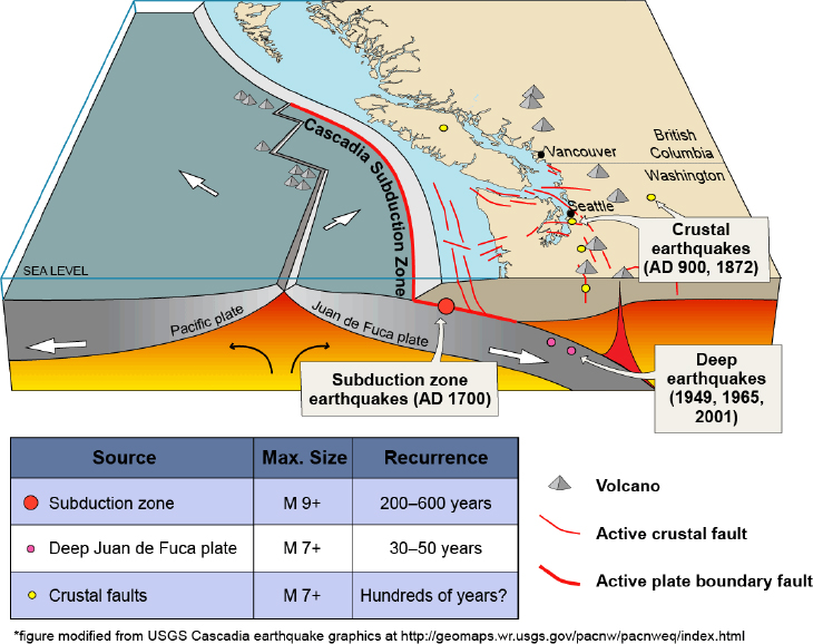
The Spirit Lake and Toutle River region is in an active geologic setting. Understanding its geology and associated hazards is important to understanding the risks associated with management decisions for the region. Mount St. Helens is part of the Cascades volcanic chain that also includes Mount Rainier and Mount Adams in Washington and Mount Hood in Oregon. This chain formed as a result of subduction of oceanic crust (the Juan de Fuca Plate) beneath the northwestern coast of North America (see Figure 2.4). The bedrock of the Spirit Lake area chiefly comprises geologically young but competent volcanic rocks, consisting mostly of andesite, basalt, flow breccias, and tuffs. Overlying these are gravelly well-drained river bottom soils in the main drainage channels and thin soil cover on the hillsides (USACE, 1984a). Subduction processes result in not only volcanic hazards but also those associated with earthquakes.
Regional Volcanism and Hazards
As the subducted oceanic crust, or slab, descends into the mantle beneath the North American Plate, it is heated and subjected to increasing pres-
sure and eventually releases fluids (mainly water). These fluids interact with the overlying mantle, the melting temperature of the slab is reduced, and the slab melts and generates magmas. The magmas ascend toward the surface, with temporary ponding at different depths such as near the base of the continental crust (about 25 miles [40 km]) and at mid-crustal levels. Types of magma are produced (i.e., calc-alkaline mainly of andesitic to dacitic compositions) with two characteristics that influence the type of their eruptions: they are resistant to flow (i.e., have high viscosities) and contain a large percentage of dissolved water.
The high-viscosity magmas can well up and out of the ground in a relatively quiet manner—referred to as “effusive”—and form dome-like structures above the volcanic vent (rather than the “rivers” of lava that occur in lower-viscosity basaltic volcanoes). One of the domes now visible in the crater of Mount St. Helens is the result of an effusive episode in 2004-2008. The large fraction (several percent by weight) of dissolved water in these magmas at depth, however, can also drive highly explosive eruptions. As magma rises and decompresses, water comes out of solution and forms bubbles that are prevented, as a result of the high viscosity, from expanding and coalescing. If the vapor cannot escape the magma (such as by leaking out the sides of the volcanic vent), a large number of small pressurized bubbles are contained within the magma as it nears the surface. Eventually this mixture blows apart, the gas expands and accelerates rapidly, and the fragments of magma that originally enclosed the bubbles are carried upward with that expanding gas, which jets into the atmosphere and feeds high-standing plumes and ground-hugging pyroclastic flows. This is the type of explosive eruption that occurred on May 18, 1980.
The combination of effusive and explosive activity contributes to the construction of composite volcanoes (also called stratovolcanoes) that typify the Cascade chain, specifically Mount St. Helens. These volcanoes are essentially piles of steep-sided lava domes and flows and loose debris deposited during explosive pyroclastic activity. The combination of contrasting materials, abundant loose debris, and steep slopes contributes to additional hazardous processes. The volcanoes themselves are very unstable; large sectors may collapse and spread over surrounding valleys as debris avalanches—mixtures of loose clastic debris and intact blocks of volcanic rock. This is often facilitated by intrusion of new magma into the volcano at the beginning of an eruptive episode. The magma inflates the volcano, steepening its slopes so that they are more prone to failure. In such cases, the ensuing debris avalanche might be accompanied by a lateral blast as the pressurized magma body explosively decompresses; the opening phase of the May 18, 1980, activity at Mount St. Helens is a classic example of this process (Lipman and Mullineaux, 1981). Debris avalanches can occur without any accompanying eruption, however.
Another hazard is a type of mudflow, referred to as lahar, in which slurries of rocks, ash, and water descend from the volcano into surrounding drainages. There are several causes of lahars: lava may melt snow during an eruption or flow from open vents and mix with wet soil and mud on the slope of the volcano; a flood may be caused by a lake breakout; heavy rainfall may occur on unconsolidated pyroclastic deposits; or there may be volcanic landslides. The lahars can grow as they flow and pick up more debris, extending tens of kilometers or more downstream and inundating rivers and valleys.
Ancient Lahars
Geologic evidence interpreted from the extent, height, and sedimentological characteristics of deposits along the Toutle River and its confluence with the Cowlitz River indicates that catastrophic breakouts of a lake in the general vicinity of Spirit Lake have occurred repeatedly during past eruptions (Scott, 1988a,b). The importance of this information for today is that the magnitude of catastrophic flooding predicted by post-1980 analyses (Swift and Kresch, 1983; Kresch, 1992) is consistent with events that happened in the geologic past and thus are plausible.
There is evidence of four lahars having been deposited during the eruptive period circa 2,500 and 3,200 years before present. In each of these events, a large flood of sediment-laden water surged down the North Fork Toutle River, entraining sediment and increasing in volume for up to 12 miles (20 km) before evolving into a lahar several times more voluminous than the original lake volume. The largest of these lahars deposited 35.3 billion cubic feet (1 billion m3) of sediment—10 times the volume of the largest lahar generated in the 1980 eruption—from the North Fork Toutle Valley. Peak discharge was estimated to be between 7.0 and 10.5 million feet3 (200,000-300,000 m3) per second, similar to that of the modern Amazon River. It inundated the site of the town of Castle Rock tens of meters deep and spread at least 6 miles (10 km) upstream and downstream of the Cowlitz River confluence. The evidence for the nature, magnitude, frequency, and age of these lahars was developed and interpreted
mainly by Scott (1988a,b) and is summarized by Grant et al. (2016a). The only imaginable source of the large water volumes needed to trigger these prehistoric lahars is the sudden release of a lake in the general vicinity of the modern Spirit Lake. Hausback and Swanson (1990) identified two large debris avalanche deposits on the northern flank of the volcano that occurred within the same 2,500-3,200 years before present period, and it is likely that these deposits dammed the predecessors of Spirit Lake and provided easily erodible material that could be entrained into water during subsequent catastrophic breaching of the debris blockages.
Region Seismicity
Earthquakes in the region originate from three sources. First, the subduction zone itself is a major fault zone, referred to as the Cascadia Subduction Zone (see Figure 2.4). Subduction is not smooth; rather, the fault system is “locked” when ongoing stresses cause strain to be stored in the system. Eventually a fault (or set of faults) fails catastrophically, releasing the stored strain and causing major earthquakes exceeding magnitude (M) 9.0. Examples of such earthquakes include the March 11, 2011, M 9.0 T![]() hoku, Japan, and the December 26, 2004, M 9.0 Northern Sumatra earthquakes.
hoku, Japan, and the December 26, 2004, M 9.0 Northern Sumatra earthquakes.
The second source of seismicity is smaller but nonetheless significant earthquakes occur along faults in the continental crust (i.e., crustal faults) above the subduction zone (see Figure 2.4). These earthquakes are often closer to the site of interest and can produce stronger shaking intensity than do more distant larger-magnitude subduction zone earthquakes. At the regional scale, the crust experiences compressive forces in the direction of subduction while local settings might also experience faulting due to extensional forces. Mount St. Helens sits atop a north-northwest trending belt of shallow crustal faults known as the Mount St. Helens Seismic Zone. These earthquakes tend to have magnitude 6.0 or less, but larger-magnitude earthquakes might be possible. Both Cascadia Seismic Zone and crustal faults are considered to be of tectonic origin.
The third source of seismicity is volcanic earthquakes caused by intrusion of magma into the solid crust. This results in reactivation of existing
fractures, opening of new fractures, and shifting of rock domains as the intrusions alter the state of stress in their surroundings. These volcanic earthquakes are key components of volcano monitoring because they allow scientists to track the motion of magma that might lead to an eruption. Volcanic earthquakes tend to be of relatively low magnitude, however, with a few reaching magnitudes of 5.0 to 6.0.
Engineering Geology of the Spirit Lake Debris Blockage
The 1980 eruption of Mount St. Helens created three debris dams that reshaped the Toutle River watershed: the Spirit Lake blockage, the Castle Lake blockage, and the Coldwater Lake blockage. The Castle Lake and Coldwater Lake debris blockages have received less attention to date. This report focuses on issues related to the Spirit Lake debris blockage, but management decisions in the region may also need to focus on the other two.
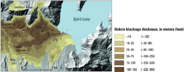
The Spirit Lake debris blockage consists of a poorly characterized (from a geotechnical point of view) chaotic, permeable mixture of sand, gravel, boulders, and organic materials. The boundaries of the blockage do not easily lend themselves to clear definition, or even to identification of exactly where the blockage begins and ends. Unlike an earthen dam, the slope of the blockage is relatively shallow. The northern boundary of the blockage abuts Johnston Ridge, while the southern boundary grades into the surrounding landscape. The materials composing the blockage are described by Grant et al. (2016a). The texture of the materials is highly variable. Little of the original competent rock from the mountain slope remains; instead, it is shattered and interlaced with sands and gravels (Glicken et al., 1989). At its crest the blockage ranges from 200 feet (60 m) to more than 500 feet (150 m) in thickness. Both the avalanche sediment and the overlying pyroclastic sediment are highly erodible.
Over geologic time, Spirit Lake has been dammed repeatedly by volcanic material, filled, and at least partially drained by overtopping failures of the blockage. Those failures caused major floods and mudflows down the North Fork Toutle River in the geological past (Scott, 1989). The surface boundary of the current Spirit Lake debris blockage is highly irregular.
It is approximately 6,400 feet (1,950 m) in length from east to west by 4,800 feet (1,465 m) in width from north to south (Glicken et al., 1989) and varies in depth up to 490 feet (150 m) (Grant et al., 2016a). Figure 2.5 depicts thicknesses of the debris blockage. The blockage is composed of highly heterogeneous materials and includes bedrock of well-lithified Tertiary tuff, andesite-and-basalt, older-dacite, ash cloud, pyroclastic flow, and phreatic deposits (i.e., derived from explosions related to subsurface steam) (Meyer et al., 1985; Glicken et al., 1989; USACE, 2016a). Figure 2.6 is an idealized geotechnical engineering cross-section of the debris blockage based on the original subsurface investigation conducted shortly after the 1980 eruption of Mount St. Helens. This simplified diagram shows three stratigraphic units divided between two basic units: debris avalanche and ash deposits. The stratigraphic units are described by the USACE (2016a) as
- Volcanic ash, which consists of primarily fine-grained deposits, highly erodible, of low unit weight. Generally 0 to 10 feet (0-3 m) in thickness, but may be as thick as 35 feet (11 m). Average standard penetration test values,2 which provide an indication of the density of the sediments, are 11 blows per foot. This value is consistent with what geotechnical engineers call loose to medium dense soils.
- Pyroclastic flow material, which consists of primarily fine-grained with up to 20% gravel. The coarse fraction is of low-density, easily erodible, widely distributed, with thicknesses ranging between 0 and 37 feet (0-11 m) in thickness, except in the pumice plain area where thicknesses are up to 160 feet (49 m) (see Figures 2.5 and 2.7). Pyroclastic flow materials can also be found in outwash areas located away from the crater of Mount St. Helens. Deposits can be 76 feet (23 m) thick. The average standard penetration test value for the material is 23 blows per foot.
___________________
2 The standard penetration test methodology is described in the ASTM International’s ASTM D1586. See https://www.astm.org/Standards/D1586.htm.
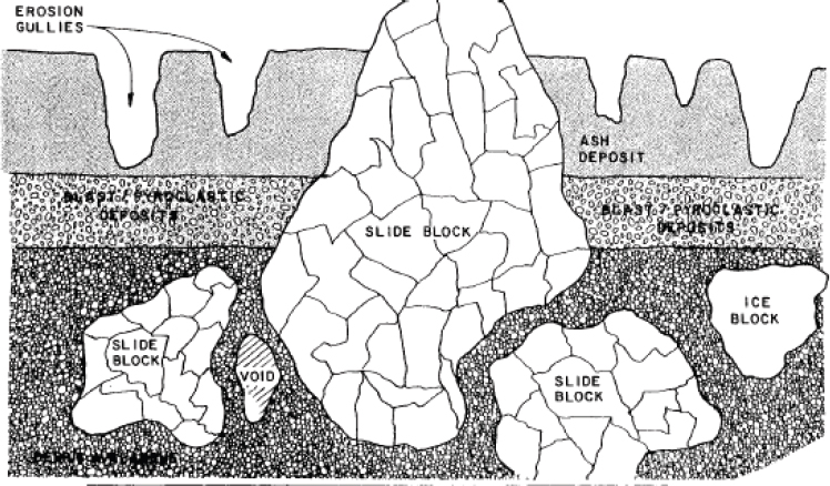
- Blast deposits, which include a wide range of particle sizes—from coarse sand to cobbles—and a variety of rock types. These are less erodible than the ash or pyroclastic flow materials. The aerial extent of blast deposits varies and thicknesses range from 0 to 131 inches (333 cm).
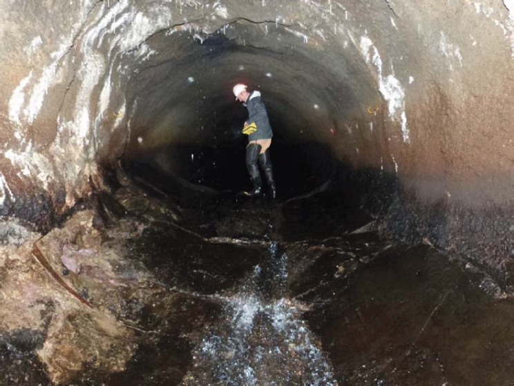
Clays and silts to gravelly sand and clasts up to meters in size can be found within the deposits (Glicken et al., 1989). The surface topography is uneven and mostly covered by the pyroclastic flow and ash cloud deposits. These highly erodible deposits vary in thickness from a few inches (cm) to 43 feet (13 m) (Glicken et al., 1989). Within a few years of the eruption, surface erosion channels and multi-meter scale seepage erosion pipes within the ash cloud deposit were observed (see Figure 2.8).
The limited test results of the geotechnical properties from the sampled materials are shown in Table 2.2 (from USACE, 2016a). In general, these materials are highly permeable, are loose, and have little cohesive
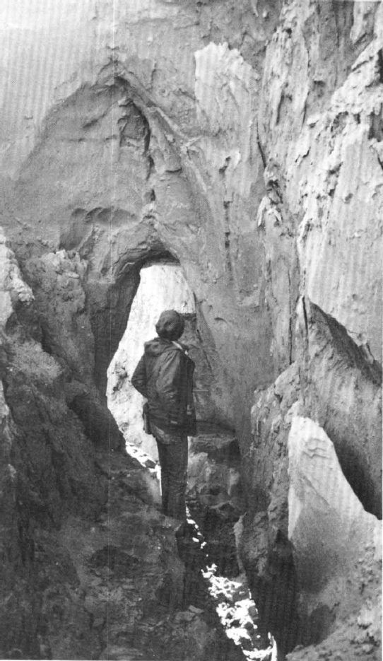
TABLE 2.2 Summary of the Geotechnical Properties of the Spirit Lake Blockage Materials
| Material | Moist Density (pcf) | Saturated Density (pcf) | Internal Friction Angle | % Fine | % Sand | % Coarse | Saturated Hydraulic Conductivity (cm/s) |
|---|---|---|---|---|---|---|---|
| Ash | 84 | 88 | 30-35 | 50-70 | 30-50 | 0-5 | 8 × 10⁻⁴ |
| Blast Deposit | 120 | 125 | 32-45 | 5-20 | 30-50 | 30-55 | 1 × 10⁻¹ |
| Pyroclastic Flow | 92 | 96 | 33-37 | 10-20 | 60-80 | 10-20 | 1 × 10⁻³ |
| Debris Avalanche | 125 | 130 | 30-45 | 5-25 | 20-60 | 30-75 | N/A |
SOURCE: USACE, 2016a.
strength. The high heterogeneity affects the distribution of shear strength and fluid flow properties of the debris blockage.
GROUNDWATER HYDROLOGY
Because the debris blockage consists of unconsolidated sediments from different parts of the original volcanic edifice with differing grain sizes, its hydraulic properties are complex. They also receive infiltrated water from a number of sources, including streams draining the volcano and Johnston Ridge. Given that the materials of the debris blockage are heterogeneous and some have low density, preferential flow paths could well develop within the debris blockage, creating a risk for the development of piping failure if the water level in Spirit Lake rises sufficiently. The groundwater flow that emerges from the avalanche deposit also drives headward erosion of the channels that feed sediment downstream to the SRS and the Toutle and Cowlitz valleys.
Assessments were made of the hydrology and stability of these deposits with respect to piping, liquefaction, failure during seismic load-
ing, and erosion soon after the 1980 eruption (Youd et al., 1981; Glicken et al., 1989), but no follow-up analysis has been conducted to determine how the hydrologic and hydraulic settings have changed, or how such possible changes affect the long-term geotechnical stability of the debris blockage. The USGS has occasionally resurveyed the eroding channels on the debris avalanche deposit to estimate its role as the prime sediment supply to the Toutle River valley (Major et al., in press), and the agency has carried out a low-resolution groundwater survey (Wynn et al., 2016), which documents the presence of a shallow groundwater body in the debris avalanche deposit.
Groundwater Flow in the Spirit Lake Debris Blockage
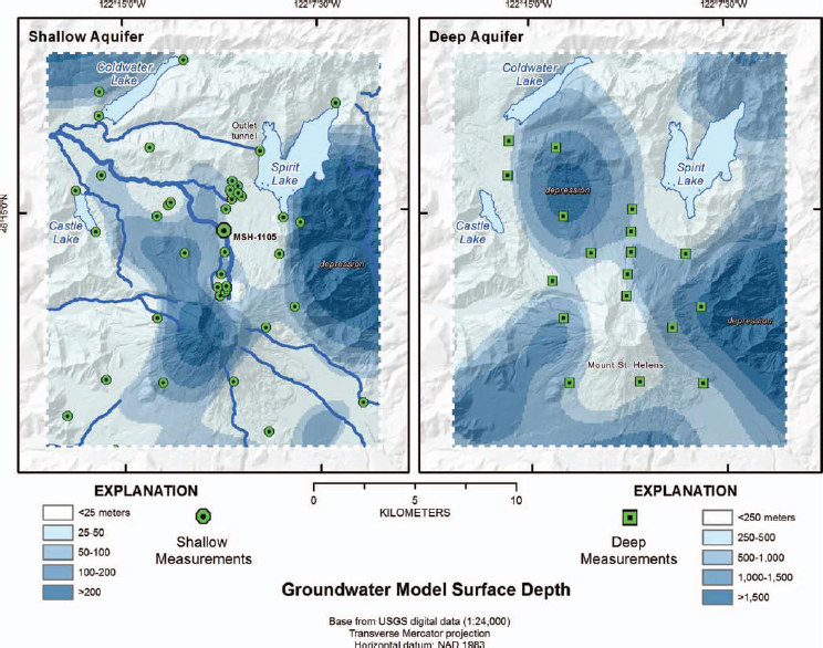
Basin-scale surface and subsurface hydrologic processes, surface erosion rates, and subsurface stability of the debris blockage are governed by precipitation patterns (rain and snow) and geologic and geomorphologic conditions. The sources of groundwater recharge in the debris blockage are the volcano itself, seepage of surface runoff from Johnston Ridge in the north, and seepage from springs near the volcano’s crater in the south (Glicken et al., 1989; Bergfeld et al., 2008; Wynn et al., 2016). Limited studies, conducted prior to 1992, indicate that responses of the groundwater system to geomorphic changes were significant after the eruption (Meyer et al., 1985; Glicken et al., 1989). In the mid-1980s the groundwater in the blockage exhibited a mound producing an easterly flow into the lake and a westerly flow into the north fork of the Toutle. The current state of the groundwater was last probed using a geophysical survey by Wynn et al. (2016) and modeled to interpolate its elevation (see Figure 2.9). Since then, few data on groundwater in the region have been collected. Groundwater recharge processes in the region are complex; approximately 43 inches (110 cm) of rainfall and 79 inches (200 cm) of snow and glacial meltwater seep through young and heterogeneous geologic media and over large varying topographic reliefs and gradients (Lee, 1996). Recharge areas have not been studied in detail, but the principal recharge in the debris blockage may come from direct rainfall.
Piezometers were installed in the debris blockage shortly after the 1980 eruption, but groundwater monitoring was discontinued after only a few years (C. Budai, personal communication, June 22, 2016). Data collected prior to 1992 indicate the water table within the debris blockage “tends to lower between the edge of Spirit Lake and areas downstream” (USACE, 2016a). According to the USACE, and based on those early piezometer readings, groundwater levels seemed to have been influenced by the flow of subsurface waters off Mount St. Helens and the area between Johnston and Harry’s Ridges. Concentrated flow seems to have developed between Spirit
Lake and downstream areas. The USACE presumed this channel “will continue to drain subsurface flows in a safe manner” (USACE, 2016a). The permeabilities of debris blockage materials, determined during post-1980 characterization efforts, indicate that groundwater can pass through debris avalanche materials more quickly than surface water can reach the phreatic surface and create a mounding effect. Permeabilities of material in the blockage typically range from moderate to high (100 to 10-4 cm/sec) and are variable (Grant et al., 2016a).
Groundwater flow within the blockage may have been a dynamic process after the eruption. Analysis (Glicken et al., 1989) indicates that groundwater in the debris blockage initially flowed from Spirit Lake through the blockage toward downstream, but then it reversed direction toward the lake. Limited water level data from within the blockage led to the conclusion that a groundwater mound or divide beneath the topographic crest of the blockage was established within a few years (Glicken et al., 1989). Groundwater flows into Spirit Lake on the east of the divide and discharges at the North Fork Toutle River on the west of the divide. This is not unexpected since this was a period of transition toward a new equilibrium.
Recent controlled-source audio-frequency magnetotelluric (CSAMT) soundings (Wynn et al., 2016) indicate that two distinct aquifer systems separated by a thick unsaturated zone in the debris blockage area may exist: models indicate that one could be 30-165 feet (10-50 m) in depth and less than 3-5 miles (6-8 km) in lateral scale, while the other is approximately 1,640-3,280 feet (500-1,000 m) in depth and more than 6 miles (10 km) in scale. The groundwater discharge rate into Spirit Lake was estimated to be likely less than 1% of the mean annual recharge of Spirit Lake (Glicken et al., 1989). Considering the length of the blockage and the elevation differences between the groundwater divide and discharge locations (Spirit Lake and the North Fork Toutle River), the average groundwater gradient within the blockage should be less than 2%, which implies modest-to-low seepage velocities.
Because groundwater has the potential to differentially erode sediments within the blockage, it is important to understand groundwater
flow within. The debris blockage consists of heterogeneous unconsolidated sediments of varying grain size from different parts of the original volcanic edifice; therefore, its hydraulic properties are complex. Lower-density materials could allow preferential flow paths to develop within the blockage (such as the piping shown in Figure 2.8), elevating a risk of failure associated with piping if water levels in Spirit Lake rise sufficiently. The groundwater flow that emerges from the avalanche deposit also drives headward erosion of the channels that feed sediment downstream to the SRS and the Toutle and Cowlitz River valleys.
Assessments of hydrology and stability of the deposits with respect to piping, liquefaction, failure during seismic loading, and erosion were assessed soon after the 1980 eruption (Youd et al., 1981; Glicken et al., 1989), but no follow-up analysis has been conducted to determine how the hydrologic and hydraulic settings have changed, or how such possible changes affect the long-term geotechnical stability of the debris blockage. The USGS has occasionally resurveyed the eroding channels on the debris blockage deposit to estimate the role of the blockage as the prime sediment supply to the Toutle River valley (Major et al., in press). Groundwater pressures and internal erosion are important factors for the long-term stability of the debris blockage.
ECOLOGICAL SETTING
The characteristics and patterns of terrestrial ecosystems of the Mount St. Helens landscape prior to the 1980 eruption were broadly representative of the Cascade Range in many respects, reflecting the interplay of gradients in soils, topography, climate, and disturbance history. Streams and lakes surrounding the volcano were numerous and diverse, with streams ranging from small, steep, cascade-dominated mountain channels to large floodplain rivers, and with lakes ranging from cool high-elevation subalpine lakes to relatively warm low-elevation lakes (Bisson et al., 2005). Swanson and others (2005: 20-26) provide an overview of the pre-eruption ecological setting, in particular, noting several specific ecological patterns regarding the ecosystems surrounding Mount St. Helens. These include
- A diverse flora predominantly consisting of a small number of coniferous tree species and many non-forest vegetation types that comprised a small, but important proportion of the landscape. Characteristic plant species and communities varied with elevation. The volcanic cone was dominated by alpine and subalpine plant communities, with the lower flanks of the mountain containing species such as western red cedar at the lowest elevations, noble fir and western white pine in mid-elevations between, and mountain hemlock, Pacific silver fir, and Alaska yellow cedar higher. Douglas-fir and western hemlock were common throughout the lower forest zones. The riparian zone was comprised of deciduous trees and shrubs, particularly red alder, black cottonwood, and willow. Patterns of dominant species also varied with time since disturbance, including past volcanic events and infrequent wildfires and, more recently, silvicultural activities, particularly clear cut logging.
- A diverse fauna characteristic of montane, alpine, and riparian habitats characteristic of Western Washington. The presence and distribution of specific habitat types across the Mount St. Helens landscape strongly influenced patterns of terrestrial vertebrates through associated controls on food availability, cover, parasites, predators, microclimate, and weather. The pre-eruption fauna, with the exception of introduced fish species, was comprised of native species, with several regional endemic species. While the invertebrate fauna of the Mount St. Helens landscape was poorly documented at the time of the eruption, it is thought to have comprised thousands of species. The Upper Toutle River watershed contains suitable habitat for several species that are listed as threatened or endangered or as USFS sensitive species. These include the northern spotted owl, peregrine falcon, gray wolf, grizzly bear, wolverine, and mountain goat (USFS, 1997). The area surrounding Mount St. Helens is also home to several regional endemics, including the Larch Mountain salamander, Van Dyke’s salamander, Cascades frog, Cope’s giant salamander, American shrew mole,
-
Cascades golden-mantled ground squirrel, and creeping vole (personal communication, C. Crisafulli to J. Kupfer, August 29, 2017).
- Stream and lake ecosystems that provided habitat for numerous species contributing to landscape biodiversity. Headwater streams were small and shallow, their channels having high gradients and being composed of steep cascades and small pools with boulder, cobble, and bedrock substrates. These streams fed into mid-sized, meandering streams and rivers with localized floodplains and more open plant canopies, which eventually drained into larger rivers with more extensive floodplains, gravel bars, and riffles. The primary river systems draining Mount St. Helens all feed into the Columbia River and, thus, the Pacific Ocean. Most lakes were formed in cirques created by Pleistocene glacial activity, although several (such as Spirit Lake) were formed in lower elevation settings where volcanic debris or lava flows blocked streams. While many lakes contained no fish until active management and fish stocking began, Spirit Lake was connected to the Toutle River system without barriers, allowing the presence of coastal cutthroat trout, winter steelhead, and coho salmon. However, stocking was common to maintain levels of these species sufficient to support a thriving sports fishery industry in the Toutle River system (Swanson et al., 2005: 20-26).
The 1980 eruption had catastrophic effects on ecosystems surrounding Mount St. Helens. The lateral blast destroyed vegetation up to 15 miles (24 km) away, and the high temperatures, debris avalanche, mudflows, and pyroclastic flows killed plants and animals near the blast area. The Washington State Department of Fish and Wildlife estimated that nearly 7,000 big game animals (deer, elk, and bear), all birds, and most small mammals died in the area most affected by the eruption (Tilling et al., 1990). The debris avalanche displaced the water in Spirit Lake, killing all the fish, and buried the upper 15 miles (25 km) of the North Fork Toutle River. Mudflows originating from the deposit extended 75 miles (120 km) down the North Fork Toutle River and main stem Toutle River valleys all
the way to the Columbia River (Swanson and Major, 2005). Catastrophic changes caused by the debris avalanche, mudflow, and pyroclastic flows decimated fish populations and destroyed 135 miles (218 km), or 77%, of the 174 miles (280 km) of the anadromous fish habitat formerly utilized by salmonids (Jones and Salo, 1986). These effects were especially devastating to fish populations in the North Fork Toutle River as they immediately killed many fish outright and modified riparian habitats, especially in the area impacted by the debris avalanche. High concentrations of suspended sediment in the Toutle River resulted in many adult spawners avoiding the river in 1980 and 1981 (Martin et al., 1984).
Management decisions made regarding the Spirit Lake tunnel and the SRS may affect a range of ecological components, a number of which were identified as important by interested and affected parties during the committee’s open session meetings in Kelso, Washington. A commonly discussed ecological concern among those participating was the state of anadromous and resident fish species. Prior to the eruption, the North Fork Toutle River valley was an important recreation area for fishers, hunters, and other users. According to Ellifrit and others (1984), the Toutle River system usually ranked among the top five streams in Washington in total numbers of sport-caught steelhead and was a popular salmon angling stream. They noted that salmon, steelhead, and sea-run coastal cutthroat all spawned naturally within the river system. The system also supported many nongame fish species, which along with the game species were important ecological components of Mount St. Helens aquatic ecosystems (Bisson et al., 2005).
Jones and Salo (1986) echoed that the Toutle River watershed sustained a thriving sport fishery that was consistently viewed as being one of the premier salmon and steelhead areas in the region. They underscored, however, that the success of that fishery had long been dependent on hatchery-raised fish. Specifically, they noted:
The Wildstock Toutle River salmon and steelhead populations, unable to sustain the exploitation rates exerted by commercial and recreational fisheries, have been augmented by artificial propagation for the past
30 years.3 The Toutle River hatchery operated by the Washington Department of Fisheries produced an annual average of 1.4 million coho salmon and 3.2 million fall chinook salmon. Prior to 1969, many Columbia River hatcheries reared and released a strain of coho salmon originating from the Toutle River. Hatchery production of coho salmon, chinook salmon, and steelhead trout produced an annual estimated catch of 251,000 fish valued at more than 12 million dollars. The Washington Department of Game annually released approximately 240,000 winter and summer run steelhead smolts into the Toutle River system. (Jones and Salo, 1986: 1-2)
It was estimated that natural spawning (hatchery and natural-origin) fall Chinook salmon from 1964 to 1979 averaged only 42% (4,517 fish) of the Toutle subbasin spawners, a number that had slipped even further by 2009.4
With respect to recovery of the fisheries since the eruption, Bisson and others (2005: 167) noted: “(M)any fishery managers predicted that recovery of salmon and steelhead populations would take decades because riverine habitats had been so extensively damaged.” In the immediate wake of the eruption, high concentrations of suspended sediment caused large numbers of adult steelhead that had been migrating toward affected tributaries, particularly those in the Toutle River system, to swim into tributaries flowing into the Columbia River upstream of their natal streams for 1 to 3 years after the eruption (Whitman et al., 1982; Leider, 1989). Small numbers of adult salmon and steelhead did navigate the sediment-laden waters of the Toutle River system and returned in 1980 and 1981, but recreational fisheries for salmon and wild steelhead were closed immediately after the eruption and not reopened until 1987 (Bisson et al., 2005). Within 5 years
___________________
3 For example, the North Toutle salmon hatchery was authorized under the Mitchell Act. It began operation in 1951 as part of the Columbia River Fisheries Development Program and was destroyed by the 1980 eruption. Operations resumed in 1985. The hatchery is operated to produce adult fall Chinook and coho salmon for commercial and sport fisheries in the northeast Pacific and Columbia River basin (see http://docs.streamnetlibrary.org/IHOT/NorthToutle-Cohos1997.pdf).
4 See http://www.hatcheryreform.us/hrp_downloads/reports/columbia_river/system-wide/4_appendix_e_population_reports/lower_col-cowlitz-toutle_fall_chinook_01-31-09.pdf.
of the eruption, juvenile salmonids were found in tributaries throughout the South Fork Toutle River watershed and tributaries of the North Fork Toutle River, except those draining the landslide debris flow areas. Nevertheless, an assessment of population viability concluded that health or viability for anadromous species ranged from very low for spring Chinook to low for fall Chinook salmon, coho salmon, and winter steelhead, leading to risks of elimination for local populations of these species (USACE, 2007).
In response to concerns about the viability of anadromous fish populations, the north and south forks of the Toutle River system were both targeted as subbasins for management of fall Chinook salmon, winter steelhead, and coho salmon in the Lower Columbia River Salmon and Steelhead Endangered Species Act (ESA) Recovery Plan (National Marine Fisheries Service, 2013). Returning and reintroduced anadromous salmon populations in the Toutle River system below the SRS have grown in recent years (Liedtke et al., 2013), although populations in the South Fork Toutle River have grown much more quickly. Natural and hatchery-produced fall Chinook and coho salmon as well as winter steelhead have returned in lower reaches of the system, but the North Fork Toutle River above the SRS remains closed to fishing. More detail about the management of fish populations is provided in Chapter 3.
Prior to the eruption, Spirit Lake itself was a popular recreational fishing destination, with steelhead and coho salmon migrating to the lake to spawn and an average of 25,000 rainbow trout stocked in the lake annually (USDA Forest Service, 1997: III-29). The first recorded fish in Spirit Lake after the eruption was a rainbow trout captured in 1993, but populations rose in the late 1990s as ecological conditions within the lake improved in the two decades after the eruption (Bisson et al., 2005). It is unknown how the first fish entered the lake, but there remains a very limited amount of stream habitat available for spawning near Spirit Lake (Bisson et al., 2005), and access to Spirit Lake from the Toutle River system remains blocked by the debris avalanche.
The issue of restoring anadromous fish to the upper North Fork Toutle River is one with not only biophysical challenges related to erosion and sediment movement into the North Fork Toutle River drainage but also
issues of access and fish passage associated with the SRS. A number of individuals at open session meetings held by the committee in Kelso and representing a diverse variety of interested and affected parties expressed interest in improving upstream fish passage and undertaking ecosystem restoration measures in the Toutle River for recreational, economic, and aesthetic reasons (e.g., reintroducing species that were once a part of the North Fork Toutle River ecosystem and economy); cultural reasons (e.g., concerns voiced by the Cowlitz Indian Tribe about the status of salmon and other species in the Toutle River system); and legal reasons (under the auspices of the ESA). Protection of endangered fish species (including issues associated with fish passage both upstream and downstream through the SRS) was a central issue in evaluating USACE plans to raise the SRS spillway up to 23 feet as part of its approach for managing sediment over the next 20 years5 (see also Chapter 3). Even when fish are able to pass the SRS (e.g., through the current trap-and-haul system), they face issues of finding suitable habitat and have no access to Spirit Lake itself because of the debris blockage and the design of the Spirit Lake tunnel.
Beyond anadromous fish species, there may be other management and legal considerations associated with the ESA. Fourteen federally or state-listed threatened or endangered species, federal species of concern, and Washington state sensitive species or state candidate species occur in the area associated with the SRS, and numerous bird species that may occur in the study area are protected under the Migratory Bird Treaty Act (USACE, 2017). The impacts of management options on other species such as elk, which are an important management component in the Mount St. Helens Wildlife Area that is administered by the Washington Department of Fish and Wildlife, may be considered.
Finally, as will be discussed at greater length in the next chapter, the Mount St. Helens National Volcanic Monument was established in 1982 from lands within and adjacent to the Gifford Pinchot National Forest in part to serve as a venue for scientific research on ecological succession as
___________________
5 See http://tdn.com/news/local/to-raise-spillway-army-corps-will-have-to-spend-millions/article_4972f60a-9dce-5089-aae7-bd7a584db181.html.
well as volcanic and seismic risks associated with Mount St. Helens. A key aspect of the Monument’s authorizing legislation (P.L. 97-243) is that the 110,000-acre (445 km2) area would be administered “to allow . . . geologic forces and ecological succession to continue substantially unimpeded,” with specific provisions and limitations regarding scientific study and research, recreational and interpretive facilities, timber harvesting, and hunting and fishing being laid out. The 1980 Mount St. Helens eruption provides the most detailed case study of volcanic impacts on ecological systems ever, with research providing exceptional insights into the survival and reestablishment of both plant and animal communities (see, for example, papers in Dale et al., 2005a), and much of that work has resulted from research conducted within the Monument. Such goals and restrictions may have potential relevance to the decision framework outlined in this report and should thus be considered.
HYDRAULIC INFRASTRUCTURE
Various engineered infrastructure elements have been constructed in the Spirit Lake and Toutle River system to control the transport of water and sediment through the system. The committee considers that these infrastructure elements are now part of the system and regional setting, serving as agents of change for the system. Moreover, the committee considers that the infrastructure elements themselves have hazards associated with them or that they may lessen or exacerbate natural hazards associated with the system. The infrastructure elements are described here and in Chapter 5 from the point of view of engineering a landscape.
Tunnel
As described in Chapter 1, a 1.56-mile (2.6-km) tunnel was constructed in 1984-1985 through Harry’s Ridge, west of Spirit Lake, to regulate lake levels and prevent breaching of the debris blockage (see Figure 1.3). Britton et al. (2016a) review the history of the tunnel, its construction, and the problems experienced with the tunnel in 1996 and again in 2014-
2015. The tunnel alignment crosses five mapped faults or shear zones. In 1992, shotcrete spalling and invert heave were detected along the Julie and Kathy L. shear zone. These required major repair of a 100-foot (30-m) segment in 1996 (see Figure 2.10). Significant distress and heave were again detected in this zone during an annual inspection in 2014 (see Figure 2.11), decreasing the hydraulic capacity of the tunnel below acceptable levels. Uplift of the tunnel floor reduced the tunnel diameter by about 30 inches (80 cm) and constricted water flow. An inspection 6 months later indicated an additional 6 inches (15 cm) of uplift. In early 2016, the tunnel was closed for 10 weeks to allow engineers to rebore a section of tunnel and install more than a dozen steel ribs to stabilize the area where the floor had been rising (Service, 2016). The repeated instances of deformation in this tunnel and subsequent congressional allocations for repair triggered the call by members of Congress for a long-term management solution (Beutler et al., 2015), as described in Chapter 1. During the repairs, completed in March 2016, the lake level rose 20 feet (6 m), only a few meters below where the more erodible deposits could be eroded by lake
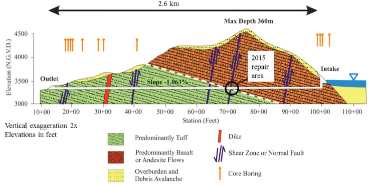
water. Engineering solutions for the control of water levels in Spirit Lake are discussed in Chapter 5.
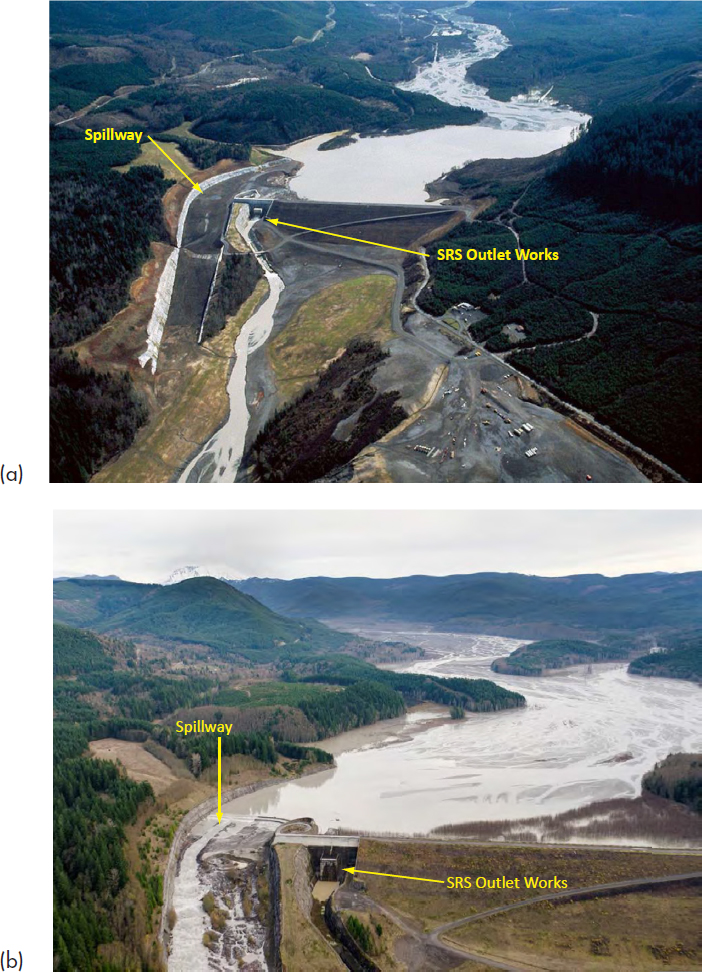
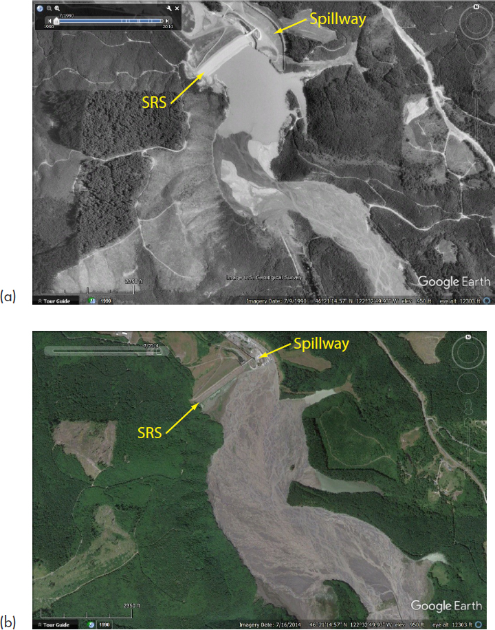
Sediment Retention Structure
The USACE completed construction of the SRS in 1989 both to reduce chronic flood risk and to reduce the need for downstream dredging. The 1,888-foot-long (575-m), 185-foot-high (56-m) structure was constructed to trap medium- to coarse-grained sediment in the basin upstream of the dam until 2035, but greater than expected sediment transport in the North Fork Toutle River resulted in sediments burying the SRS outlet pipes earlier than expected. Flow from the North Fork Toutle River has been diverted to the SRS spillway, and some sediment now passes freely over the spillway.
Based on discussions with interested and affected parties during the committee’s open session meetings in Kelso, the management of sediments in the region represents a controversy. The valley immediately upstream of the SRS, known as the sediment plain, grew rapidly as sediment accumulated (see Figures 2.12 and 2.13) behind the SRS. The landscape of the valley has been radically altered, and residents of the region expressed concerns about the ecological and economic health of the region. Passage of anadromous fish, for example, is negligible (at best) beyond the SRS.
The committee is not aware of a potential failure mode analysis that may have been conducted for the SRS in light of large volcanic, seismic, or atmospheric events for the region. A limited number of numerical simulations have been published that, for example, consider the effects of catastrophic floods and debris flows on the SRS capacity (e.g., Denlinger, 2011). Those studies, however, may assume no ill effects on the structure itself. The management of the SRS is described in Chapter 3. A limited number of alternatives for future management of the alternatives have been considered by the SRS and these are discussed in Chapter 5.
Levees
Communities located along the Toutle and Cowlitz Rivers are protected by flood levees with authorized levels of protection (LOPs) from 118-year (p=0.0085) to 167-year (p=0.006) return periods. Leveed areas along the lower Cowlitz River and property in leveed areas are valued at about $3.65 billion (USACE, 2017); they include portions of Longview, Kelso, Lexington, and Castle Rock (population of approximately 50,000). The most recent comprehensive LOP update was performed in 2009 for the Cowlitz River Levee Systems, 2009 Level of Flood Protection Update Summary (USACE, 2010a). This resulted in updates to the Cowlitz River discharge-frequency curve, stage-discharge relationships, (geotechnical) fragility curves for the levees, and an appraisal of hydraulic and hydrologic uncertainty. Uncertainty in river stage from that study is reported to have a standard deviation of 0.5 to 1.3 feet (0.15 to 0.4 m) along the river comprising natural, model, and sediment (from Mount St. Helens)
contributions. The part of the uncertainty due to sediments effects, which derives both from channel bed form and high sediment loads during storms, ranges from 0.25 to 0.7 feet (0.08 to 0.21 m), depending on location along the rivers. Sediment from Mount St. Helens deposited in the reaches of the Toutle and Cowlitz Rivers increases bed elevations and decreases discharge capacities of the reaches, raising the stage-discharge curves and thus the stage-frequency relations (i.e., annual exceedance probabilities).
SOCIO-DEMOGRAPHIC AND ECONOMIC SETTING
The socio-demographic and economic characteristics of the region, including those of Native American Tribes in the region, are important to the development of any long-term management plan for at least two reasons. They define the setting against which many of the impacts of engineering and management interventions must be measured, and the knowledge of the history and the current role of various groups and entities facilitates the identification of interested and affected parties who may be participants in plan development.
Mount St. Helens itself is located in Skamania County, Washington, but the concerns that are most central to this report (especially those associated with the Toutle and Cowlitz Rivers) focus primarily on impacts likely to be felt in adjacent Cowlitz County. The area was inhabited by Cowlitz and other Native American Tribes prior to contact with the Pacific Fur Company in 1811 (Cowlitz Indian Tribe, 2016). The indigenous population was forcibly removed from the area in 1855; many were sent to reservations in other parts of the state, but their descendants subsequently returned. Anglo-European settlement in the region, including what is now Cowlitz County, began in the early 1800s and centered primarily on trapping and the fur trade. The Hudson’s Bay Company established the first permanent settlement in the area in 1825, but development began in earnest after 1920 when R. A. Long established a sawmill in Longview (Weber, 2012). That business was among a number of entities owned by Long and his Long-Bell Lumber Company, based in Kansas, which was the
largest timber operation in the world when it opened in 1924. Longview was originally established to provide housing for workers.
Today, Longview is the largest community in the county, with a population of 37,000, and is the site of the county’s major port (U.S. Census, 2016). Kelso, the county seat, is the second-largest community in the county, with a population just under 12,000. The county had an estimated population of 103,468 in 2016. The population is 86% non-Hispanic white, 7% Hispanic, and 2% Native American. About 1.4% of the population is of Asian descent, and 3% claim two or more different racial backgrounds. African Americans make up less than 1% of the population. In 2014, 15% of residents 25 years of age or older had a bachelor’s or an advanced degree, compared with 33% of the state population and 30% of the U.S. population.
Major employers in the county include Weyerhaeuser Timber Company, International Paper (formerly Long-Bell Lumber Company), Kapstone Paper (formerly Longview Fiber Company), Alcoa, PacifiCorp (formerly Pacific Power and Light), Peacehealth/St. John’s Medical Center, the county government, and the school system. As of 2013, the estimated median household income in the county was $48,417 (compared to a state average of $58,105). In the 1970s, manufacturing accounted for approximately one-third of all jobs in the county; now the proportion is around half that number. For the past 2 decades, unemployment in the county has been about 2% higher than the national average (Bailey, 2016). The median value of owner-occupied housing units in the county for the years 2010-2014 was approximately $175,000, lower than the statewide average of $257,000. Following state and national trends, housing prices in the county improved in 2015. Thirty-two percent of county residents are renters.
The county was hard-hit by the 2008 recession, with job losses particularly marked in the construction and manufacturing sectors. Men were disproportionately affected by the recession because of their high representation in those sectors. Post-recession jobs recovery began slowly, but employment had recovered by 2015. Jobs that have returned, however, are lower-wage than the manufacturing jobs they replaced (Bailey, 2016). Hope for better employment prospects has been spurred by recent plans to build a methanol plant at the Port of Kalama (Luck, 2015). Discussions
between committee members and community representatives held during the committee’s open session meetings indicate that residents also hope for increases in tourism and recreational travel.
The county’s strategic plan for the years 2016 to 2020 (Cowlitz County Department of Emergency Management, 2016) highlights several challenges with respect to residents’ overall well-being. The plan describes the population of the county as “older, poorer, and less diverse than the rest of Washington.” The proportion of the population living below the federal poverty line is 13.5%. The county ranks high in the need for tenant assistance because of the lack of affordable rental housing, and about 34,000 residents receive Medicaid. The 2016-2020 strategic plan notes that public perceptions regarding the county are not optimistic, owing to such factors as job insecurity, unemployment, and low wages. Census and other data, as well as the appraisals of community residents and leaders, indicate that Cowlitz County has been negatively affected both by general economic trends and by economic forces specific to the region. Residents’ views on long-term management options will undoubtedly reflect those concerns.
The Cowlitz Indian Tribe
The Cowlitz Indian Tribe is another influential force within the region. It and other tribes in the region are sovereign nations and therefore important stakeholders in decisions regarding Spirit Lake and the Toutle River system. The Cowlitz Indian Tribe, federally recognized in 2000, is headquartered in Longview, although reservation land is located in nearby Clark County, near the town of La Center. Although no part of the Spirit Lake and Toutle River system crosses reservation lands, the tribe, which retains hunting and fishing rights on its traditional lands, is a party to a memorandum of understanding with the Washington Department of Fish and Wildlife that focuses on the need for cooperation and communication aiming at maintaining the health of the fish and wildlife populations in the region. The Cowlitz Indian Tribe has natural resources and fisheries departments (with the scientific and technical expertise contained therein) within its governing structure that informed a 2014 letter to the USACE
from Cowlitz Tribal Council Chairman William Iyall regarding a USACE (2014) report on the long-term sediment management plan and supplemental environmental impact statement (personal communication William Iyall to Jose L. Aguilar, October 23, 2014). The letter expressed concerns regarding, among other issues, the health of fish populations affected by the SRS, fish passage, and flood protection. Importantly, the letter stressed the need for systematic assessments of the success of previous mitigation actions and for more information on how both past actions and future plans will affect tribal interests. Concerns of the Cowlitz Indian Tribe and its relationship to the land and other interested and affected parties are described in Chapter 3.
HOW THE SETTING AFFECTS SYSTEM RISK ASSSESSMENT AND LONG-TERM MANAGEMENT
Information on the regional setting contained in this chapter has a number of implications both for assessing risks and for making decisions about long-term management of the Spirit Lake and Toutle River system. Key among these are the fact that the physical setting is complex and dynamic, that socioeconomic considerations, including tribal concerns, are part of the decision landscape, and that decision making needs to be based on a holistic conceptualization of the region and issues. The next sections summarize those concepts.
A Dynamic Region
The area of interest has been and continues to be shaped both by naturally occurring events and by engineering solutions designed to mitigate the impacts of those events. The most recent disaster that affected the region was the catastrophic eruption of Mount St. Helens in 1980, but that event occurred in the context of ongoing volcanic, seismic, and hydrological processes. Those conditions will be explored in greater detail in subsequent chapters, but a crucial finding from the discussions in this chapter is that management decision making needs to take into account the future effects
of multiple hazards on the region. Engineered works do contain some of the adverse effects of the 1980 eruption, but they have also had adverse effects of their own. For example, the SRS has resulted in the trapping of sediments upstream of the structure, changing the landscape of that region and having wide-ranging effects on fish species that are valued by many local stakeholders. The tunnel designed to regulate water levels in Spirit Lake may be vulnerable to natural hazards such as earthquake-related movement. Repairs of the tunnel result in the need to temporarily close the tunnel, leaving the debris blockage vulnerable to rising water levels. Maintenance and repair of the tunnel also puts workers at risk.
Within this dynamic setting are many uncertainties that will have to be taken into account in long-term management decisions. In many cases, uncertainties have been compounded by data gaps, a lack of ongoing monitoring, and failure to consider potential sources of vulnerability. The need for future studies to better characterize hazards and vulnerabilities and to reduce uncertainty is an ongoing theme in this report.
Socioeconomics and Tribal Concerns as Part of the Decision Landscape
Decision making needs to be informed by more than the physical characteristics of the region. Socioeconomic conditions and tribal concerns are also part of the decision landscape. Although economic conditions have improved since the 2008 financial crash, incomes in Cowlitz County are low compared to statewide averages, and overall economic growth has been sluggish. Before the eruption of Mount St. Helens, the region enjoyed the economic benefits of recreational travel centered on fishing, hiking, and other outdoor pursuits, and many local stakeholders hope for a return of those types of recreational opportunities. Timber harvesting remains an important contributor to the region’s economy, and the health of the federal, state, and private forests may be affected by management of the Spirit Lake and Toutle River system.
The Cowlitz Indian Tribe represents another set of interested and affected parties that have a special interest in conserving and restoring the region’s wildlife and in agency accountability with respect to those con-
cerns. Maintenance of cultural and religious practices is also a major tribal priority. The tribe is unlikely to accept long-term management decisions that do not take these interests into account.
Holistic Conceptualization
An understanding of the regional setting calls for a more holistic conceptualization of that system that should form the basis for long-term decision making. Spirit Lake, the Toutle River, and associated engineered works are elements within a broader regional system that includes many other features such as the Monument, the Cowlitz and Columbia Rivers, and downstream flood protection levees. Elements within that system are managed by different entities—a point that will be emphasized in Chapter 3—and are often considered in isolation from one another. Those facts cannot stand in the way of formulating and implementing a decision framework that accounts for interrelationships and feedback processes within the broader system.


