
CHAPTER 5
The Engineered Landscape
A sense of urgency pervaded public and official response to the 1980 eruption of Mount St. Helens. As a result, an engineered landscape was created in the Spirit Lake and Toutle River system to protect people and property downstream from the natural hazards associated with water and sediment. A landscape is engineered based on the values and perceptions of risk held by interested and affected parties. Such perceptions and values are not static, but change with time. Although it has been one-third of a century since the original decisions about hydraulic infrastructure in the system were made and implemented, management approaches in the region do not seem to have evolved commensurate with changes in values and risk perception. This chapter considers the engineered landscape, approaches to managing that landscape today, and the information needs associated with it. Nonengineering (i.e., nonstructural) measures have also been implemented, but these are not included in this discussion.
An assemblage of hydraulic infrastructure was planned and built in the 1980s, including provisions to maintain water levels in Spirit Lake by boring a drainage tunnel, modifications to Coldwater and Castle Lakes, changes in the North Fork Toutle River channel, the addition of the sediment retention structure (SRS) to capture sediments before they could enter the Toutle and Cowlitz Rivers, and flood levees farther downstream. The infrastructure reflected risk perception and values of the time as well as the best judgment of responsible authorities. Management strategies to date have focused principally on expedient engineering solutions rather than a systems approach. Decades past the initial response, values such as
those related to provision of ecological services and recreational benefits have gained currency in stakeholder perceptions. The dangers posed by hydrology, volcanism, and seismicity have not abated, but they have been lived with for 35 years, including by a generation that knows no other way of life. In the minds of many interested and affected parties, the hazards may not rival other consequences of the engineered landscape in importance.
The approach to choosing among alternatives for managing the region is described in the decision framework of Chapter 6. When considering alternatives, it is advantageous to consider the broad physical and social system within which they function and to recall long-standing principles of design practice for achieving reliability and safety. Whereas the committee recommends a systems approach to management of the region that considers both physical and social systems and solutions, such an approach has not been taken to date. Given the importance of both physical and social systems, discussion of the hydraulic infrastructure and decisions related to it are described separately in this chapter. Integrating risks associated with all these elements in a probabilistic risk assessment (PRA) is addressed at the conclusion of this chapter.
SPIRIT LAKE WATER LEVELS AND RISK OF CATASTROPHIC FLOODING
Long-term management of Spirit Lake is of major concern because control of the lake level is instrumental in avoiding massive flooding downstream caused by breaching of the debris dam impounding the lake. Chapter 4 summarizes potential breaching flood hazards as modeled by Swift and Kresch (1983), Dunne and Fairchild (1984), and Kresch (1992). The conclusion was that the consequences of a dam-breach flood from Spirit Lake would be catastrophic. An estimate of fatalities was not made; rather, the extent and depth of inundation were estimated, but there would be fatalities—possibly many. The reports and analyses of the period (USACE, 1983) reflect this emphasis on danger.
In response to concerns about rising Spirit Lake water levels, and as described in Chapter 3, the U.S. Army Corps of Engineers (USACE)
stabilized lake levels on a short-term emergency basis in 1982 with barge-mounted pumps. Subsequently, four long-term alternatives to control water levels were considered: a buried conduit through the blockage, a surface channel over the blockage, a drilled tunnel through rock (with several possible alignments), and permanent pumping. Although the USACE initially identified the buried conduit as the preferred alternative (USACE, 1983), the 8,600-foot (2,600-m) tunnel through Harry’s Ridge was ultimately selected, which drained Spirit Lake water to South Coldwater Creek and then to Coldwater Lake, which by that time had itself been stabilized with a drainage channel across a natural bedrock sill. The capacity of the tunnel was designed to accommodate a p=0.01 annual chance (i.e., 100-year return period) flood followed by the Probable Maximum Flood (PMF) (see Box 5.1). The tunnel became operational in May 1985, and ownership of the tunnel was transferred from the USACE to the U.S. Forest Service (USFS). The geologic conditions, design, and subsequent performance of the tunnel are summarized by Grant et al. (2016a). The tunnel is the sole means of controlling water levels in Spirit Lake. Failure of the tunnel or its
long-term closure would leave the lake vulnerable to water level rise that, in turn, could lead to catastrophic failure of the debris blockage.
The tunnel is shut off and inspected annually. In the 1992 inspection, swelling and distress were observed within a 100-foot (30-m) section where the tunnel crosses a wide shear zone (see Figure 2.11). The tunnel was closed for repair in 1995 and 1996, during which time a stronger support system was installed within the affected section. There has been no sign of continued squeezing in the repaired section (Britton et al., 2016a), but squeezing has been observed in adjacent sections. Following the annual inspections of 2014 and 2015, the conclusion was drawn that another major repair is required. The committee is not aware if the deformation in the shear zone has been sufficiently characterized to determine if it is the result of heave or of movement along the fault. Similarly, the committee is not aware if there is potential for movement or deformation along the several other mapped shear zones or how such movement might affect the tunnel. Long-term operation and maintenance of the tunnel need to be informed by such analyses and also by analyses of the response of the tunnel to seismic shaking, to a large flood event that would fully pressurize the tunnel, and to other tunnel collapse scenarios.
Future Spirit Lake Management Alternatives Under Consideration
The USACE, in cooperation with the U.S. Forest Service (USFS), the U.S. Geological Survey (USGS), and the U.S. Bureau of Reclamation (USBR), conducted a potential failure modes analysis (PFMA) of four conceptual alternative Spirit Lake outlet strategies, which are listed in Table 5.1. The alternatives and the PFMA process are summarized by Grant and others (2016a). Among the goals of the analysis was identification of uncertainties and risk drivers. It appears that the best available scientific and engineering information was used for the specialized purpose of identifying the potential failure modes of five drainage concepts: the existing tunnel, the tunnel and its possible repair, a shallow conduit, pumping, and an open channel. Protocols followed during the analysis
TABLE 5.1 PFMA Alternatives for Managing Water Levels at Spirit Lake
| Alternative | Hydraulic Release Capacity |
|---|---|
|
3' gate opening |
|
4' gate opening |
|
Same hydraulic capacity as full open tunnel |
|
Same hydraulic capacity as full open tunnel |
|
Unknown |
SOURCE: USACE, 2016a.
were developed by the USBR and the USACE within the context of the federal dam safety initiative. The committee did not have direct access to the PFMA, and information about and conclusions drawn regarding the PFMA are based on summaries provided by Grant and others (2016a) and discussion with those authors during open sessions of committee meetings. The following text from Grant and others (2016) summarizes the procedures used in the PFMA.
The risk assessment includes a consideration of the likelihood of breaching of the blockage and an uncontrolled release of Spirit Lake as well as potential consequences should breaching occur. The likelihood of a release of lake water is a function of the likelihood that the posited loading process will occur, the likelihood it will cause the outlet to fail and allow the lake level to rise, and the likelihood that an intervention to prevent breaching of the blockage will be unsuccessful. After estimating the joint probability of this chain of events for each potential failure mode, the
likelihood that a failure (lake release) will occur was broadly categorized. The team also assigned a level of confidence to the failure likelihood. (82)
The committee interprets the PFMA process to have been based on scientific and engineering judgment rather than on quantitative modeling and analyses.
A PFMA is intended to identify possible modes of engineering failure of constructed dams but was applied in this case to determine modes of failure of the Spirit Lake debris blockage. The PFMA involved only conceptual-level designs, however. No specific engineering designs were evaluated that would require quantitative engineering data, and no quantitative risk analysis was done that would require quantitative data on engineering performance. A full quantitative risk analysis would require broader and more detailed information. Because the PFMA did not include a formal quantitative analysis of the probabilities of failure modes, it is thus not a probabilistic risk assessment in the sense that the term is normally used in federal practice (NRC, 1994). Four significant uncertainties that drive risk for the tunnel option were identified, as was a qualitative description of the likelihood of failure for each of the drivers (see Table 5.2).
The probabilities of the drainage failure modes were judged on a seven-step ordinal scale from “remote” to “failure observed.” These are failure modes of the drainage system, not of the blockage. With respect to a breaching failure of the blockage, two breakout scenarios were identified: (1) seepage through the blockage leading to internal erosion and (2) knickpoint erosion undermining the blockage and creating a channel (see Figure 5.1). These were not assigned probabilities: the presumption is that if the lake level achieves a critical elevation, breakout will occur. The committee did not have direct access to the results of the PFMA; instead, it relied on the summary by Grant and others, on discussions with some of those who participated in the PFMA, and on limited unpublished materials provided by the USACE in response to specific requests for information.
Alternate drainage directly to the North Fork Toutle River by means of pumping had been used before the tunnel was constructed in 1985, and it has been proposed as an alternative for the future either by constructing
TABLE 5.2 Potential Significant Risk Drivers for Existing Tunnel
| Potential Significant Risk Driver | Failure Likelihood (confidence) |
|---|---|
| Probable maximum flood event overtops intake structure and leads to tunnel failure. Lake rises to elevation of contact between debris avalanche and overlying ashcloud deposit. Seepage erosion within ashcloud deposit leads to failure of debris blockage. | Remote (low) |
| Earthquake leads to significant displacement along faults crossing tunnel, which leads to tunnel blockage or failure. Lake rises to elevation for internal seepage erosion. | Remote (moderate) |
| An eruption triggers a lahar that flows into Spirit Lake and produces a debris-laden wave that damages intake structure and blocks flow into tunnel. Lake rises to elevation for internal seepage erosion. | Remote (moderate) |
| Extended closure during major tunnel repair leads to precarious lake level followed by significant hydrological event that results in uncontrolled flow into the tunnel. Tunnel subsequently fails. | Moderate (low) |
SOURCE: Grant et al., 2016a.
a conduit (alternative 4 in Table 5.1) or an open channel from the south side of the lake (alternative 5) or by perpetual pumping (alternative 3). Changing the outflow works at Spirit Lake—for example, by shifting more or all the drainage now flowing into South Coldwater Creek to the North Fork Toutle River—could change the pattern and volume of erosion and thus the amount of sediment transported to the SRS. The current outflow of Spirit Lake averages about 300 cfs (cubic feet per second) (8.5 cms) with a target of 400 cfs (11.3 cms) under optimum conditions. This discharge
TABLE 5.3 Summary of Natural Hazard Events for Managing Spirit Lake Drainage
| Hazard | Examples |
|---|---|
| Hydrologic hazards | Typical wet season, atypical wet season, PMF-type extreme event |
| Seismic hazards | Shallow crustal earthquakes, deep intra-slab earthquakes, megathrust earthquake |
| Volcanic hazards | Lahars, tephra fallout, pyroclastic flows, lava flows |
| Geomorphic hazards | Landslides (shallow and deep), channel avulsion across debris deposit, channel incision, knickpoint development, sediment transport |
flows into Coldwater Creek, on a hard surface with minor erosion and sediment generation, and then into Coldwater Lake.
Each of the alternatives assessed during the PFMA was evaluated in consideration of the same hydrologic, seismic, and volcanic loadings. For example, from a hydrologic perspective, the analysis considered whether or not the drainage tunnel could safely pass the PMF. The PFMA also considered annual probabilities of maximum reservoir stage. No new data were gathered specifically for the PFMA, and no site-specific seismic analysis was conducted. Grant and others (2016a) note that the PFMA was informed by numerous completed regional studies that related to the Mount St. Helens Seismic Zone since the original tunnel was designed and constructed. The alternatives considered in the PFMA were not expanded beyond those considered in the 1980s. The performance of the engineered infrastructure is driven in large part by the hazards affecting management of Spirit Lake as identified by Grant and others (2016a), as summarized in Table 5.2 and as described in Chapter 4. These hazards affect human use of the landscape by influencing catastrophic and chronic flooding, sediment impacts, most ecological processes, and recreational values.
Uncertainties Regarding the Outlet Tunnel
A number of uncertainties were identified by Grant and others (2016a) with respect to the management of the Spirit Lake tunnel. One of these is hydrological, relating to a need for better characterization of the PMF draining into the lake (see Box 5.1). The USACE has recently conducted a great deal of work to improve the characterization of the PMF (USACE, 2016a). This work seems an adequate reflection of the current state of the art with respect to hydrology. The other uncertainties are geotechnical, having to do with the geometry, material properties, groundwater conditions, and seismic performance of the tunnel and the blockage. A summary of information needs with respect to the outlet tunnel is shown in Table 5.4.
In contrast to the amount of work done on the hydrology of Spirit Lake, up-to-date information on the geometry, geotechnical properties, and groundwater conditions of the blockage confining Spirit Lake need
TABLE 5.4 Geotechnical Information Needs Related to the Spirit Lake Outlet Tunnel
| Type | Description | Justification |
|---|---|---|
| Engineering geology | Detailed geologic mapping of the tunnel. Stabilization of slopes at tunnel inlet and outlet portals. | Extending the life of the tunnel for the next 100 years will require an upgrade of the tunnel lining. Detailed engineering geology mapping is required to decide feasibility and to develop plans to improve the tunnel lining. Long-term stability, including seismic stability of the portals, is important for extending the design life of the tunnel. |
| Fault geology | Mapping of faults and shear zones crossing the tunnel and evaluating their aseismic and seismic deformation potential. | Understanding potential fault displacement is necessary when considering the repair and long-term operation of the tunnel. The current information of the shear zones crossing the tunnel alignment may not be adequate. |
| Mount St. Helens Seismic Zone | Detailed evaluation of the source zone, potential extent of fault displacement, and strength of shaking. | This is necessary to evaluate the seismicity in this area and potential impact of fault rupture on the tunnel and debris blockage. |
| Site-specific seismic hazard analysis | A detailed seismic hazard analysis, including estimates of fault rupture and ground motion shaking, is needed as part of the rehabilitation of the existing outlet tunnel. | Generic data on seismicity in the region are insufficient for engineering safety evaluation of the tunnel. |
to be updated. Little information on geotechnical conditions has been gathered since the 1980s. While it is possible—and perhaps even likely—that the groundwater conditions have changed little since the 1980s, and although geophysical studies have been conducted since, it is essential to verify current geotechnical conditions to serve as the basis for quantitative analysis.
Uncertainties Regarding the Debris Blockage
A site characterization program was undertaken in the 1980s and is described in Chapter 2. An important finding of the characterization work was that the overlying ash deposits (see Figure 2.6) are likely to be susceptible to internal erosion and piping. Reducing uncertainties related to the geotechnical properties and behavior of the blockage is mostly a matter both of obtaining better and more recent in situ data and of performing more extensive engineering analyses (Wynn et al., 2016).
The groundwater regime does not appear to have changed significantly in the intervening years based on geophysical testing conducted in 2016 (Wynn et al., 2016; see Figure 2.9); however, the extent of site characterization in the 1980s using borings as well as that in the 2000s using geophysics is limited. Considerable uncertainty appears to remain about groundwater, pore pressures, and seepage within the blockage. The blockage is the linchpin in the Spirit Lake system. Were it not for the blockage, the concern over a breakout flood from Spirit Lake would be moot. Therefore, while the blockage appears to be stable, and while there have been few indicators in recent years of its mis-performance, prudence nonetheless indicates that an assurance of its current condition be confirmed.
To evaluate the possibility of using a surface channel to drain Spirit Lake, information is needed on the current geotechnical properties of the blockage and of the groundwater regime; the geometry that such a channel would require (e.g., it was suggested in the committee’s meetings that this channel would be too steep to accommodate fish passage or a sandy bottom); and the maintenance requirements necessary to maintain such
a channel. Much of this information was presumably considered in the 1980s at the time of the original drainage decisions, but such information would need to be updated, and economics studies (i.e., benefit-cost analysis) would probably need to be updated as well. There is nothing particularly difficult about collecting such information and making the related engineering and economic decisions, yet little modern engineering information has been collected since the 1980s.
A summary of information needs with respect to the debris blockage is shown in Table 5.5.
Other Alternatives
Applying traditional principles of reliability and safety (see Box 5.2) is good engineering practice, and such principles were recognized in the PFMA process as reflected in the following passage from Grant and others (2016a):
During the risk assessment process and at other junctures, the question was raised as to whether there should be redundant or backup mechanisms for getting water out of Spirit Lake. By this view, adoption of any new alternative for releasing water other than rehabilitating the existing tunnel would include maintaining the existing tunnel as a backup should the new design fail. (112)
The principle of redundancy of reliable design, however, was not accepted based on cost:
This option was not rigorously analyzed. While superficially an attractive option, a problem with this approach is that maintaining dual infrastructure could double the amount of repair and maintenance required in order to keep both outlets functioning. Since the overarching objective of the risk assessment is to identify alternatives for safely draining the lake which require less intervention, having to maintain two facilities instead of one appears impractical. (112)
TABLE 5.5 Information Needs Related to the Debris Blockage
| Type | Description | Justification |
|---|---|---|
| Geology | Accurate and precise mapping of the contact boundary between debris avalanche and overlying pyroclastic deposits. High-resolution delineation of the contact between boundary of debris avalanche and underplaying rock. | Important in confirming critical elevation for breakout flood calculation and whether changes have occurred since the 1980s. Critical boundary for groundwater seepage and debris blockage stability analysis. |
| Geomorphology | Detailed mapping of the landscape evolution of the debris blockage since the 1980 eruption. | Critical in identifying current condition of surface erodibility for open channel and buried conduit alternatives should these be reappraised. |
| Hydrogeology | Detailed observation and description of the water table configuration and its evolution since the 1980 eruption to within modern margins of error for groundwater surveys. | Critical for identifying current conditions of permeability structure, piping development, debris blockage stability, and open channel and buried conduit alternatives. |
| Geomechanics | Detailed characterization of the heterogeneity of debris blockage (pyroclastic, deposits, debris avalanche, and underlying rock) in shear strength and erodibility. | Critical in assessing current conditions of piping development, debris blockage stability, and open channel and buried conduit alternatives. |
Despite this view, the committee heard from various interested and affected parties in attendance at the committee’s information gathering sessions, including some USFS staff, that redundancy in protection was desirable. Any trade-off of safety (or other desired outcome) against financial cost is one that should be engaged within a transparent decision process involving
interested and affected parties. The process may determine that the cost of redundancy is too high to be practical, but that is a trade-off to be made and quantified during application of a decision protocol. Guidance for making those determinations is provided in Chapters 6-8. It is also within the context of the decision framework that engineering and nonengineering solutions could be considered together to offer redundancy, where possible. Whatever solutions are ultimately considered, it needs to be remembered that if a reduction to a specific risk level by a given date is the desired outcome, then the specific actions in their appropriate sequence and estimated costs will need to be incorporated into the analyses of alternatives (discussed in Chapter 7).
As part of its task (see Box 1.1), the committee was asked “to identify possible alternatives for long-term management” of the Spirit Lake and Toutle River system. Considering other alternatives is consistent with the traditional principles of reliability and safety. The study sponsor, the USFS, understood that the committee would not provide a comprehensive list of alternatives nor would the committee assess the viability of any options. The purpose of the request was to inject potentially new ideas into future decision-making processes, the viability of which would be quantified in future efforts by the USFS and other agencies with management authority in the region. The next sections summarize some of the ideas generated during the committee’s brainstorming exercises. They are rough ideas, however, based on limited data, and therefore do not represent recommendations.
LOWERING THE LEVEL OF SPIRIT LAKE
Spirit Lake is a large body of water capable of producing catastrophic losses given catastrophic failure of the debris blockage. By maintaining a lower lake elevation and thus reducing the volume of water, the probability and consequences of risk in terms of loss of life and property could be lowered. The operating elevation of the lake is set at 3,440 feet (1,049 m), although it rises annually to about 3,448 feet (1,051 m) (see Table 5.6). This is a management decision, the justification for which is described in Grant
TABLE 5.6 Key Elevations Related to Spirit Lake
| Elevation (m) | Elevation (ft) | |
|---|---|---|
| Crest of debris dam | 1,079 | 3,540 |
| Maximum operating level of lake | 1,055 | 3,460 |
| Safe operating level of lake | 1,049 | 3,440 |
| Gate bottom elevation | 1,030 | 3,379 |
| Depth of lake | 56 | 185 |
SOURCE: Britton et al., 2016a.
and others (2016a). Briefly, it is determined that the “effective dam crest elevation,” representing the contact between the debris-landslide deposit and the overlying pyroclastic deposits is located at approximately 3,490 feet (1,064 m). This contact elevation is relevant because of the erodibility of the pyroclastic materials. Water above that elevation could rapidly erode the pyroclastic materials. It was further assumed that both debris-avalanche and pyroclastic deposits would eventually consolidate, which would lower the contact point by as much as 15 feet (5 m), to an elevation of 3,475 feet (1,059 m). A piping analysis conducted by the USACE suggested that piping failure could occur with a sustained lake level above 3,460 feet (1,055 m) (USACE, 1983; Sager and Chambers, 1986). This elevation was thus chosen to be the safe lake level. To provide for short-term storage capacity to cope with potential hydrologic and volcanic events, a freeboard of 18 feet (6 m) was deemed necessary. Thus, the safe operating elevation was set at 3,440 ft. The elevation of the tunnel control structure is at 3,475 feet (1,059 m). That elevation is important not only because of the presumed interface between the more competent and permeable strata of the debris blockage but also because the tunnel becomes fully pressurized above that level and may suffer damage.
There appears to be no engineering reason why the lake could not be drawn down to further reduce risk. It is possible, however, that reducing storage by lowering the operating lake elevation could increase flood heights in the Toutle River downstream. Additionally, Spirit Lake provides recreation and ecosystem services (e.g., aquatic habitat), and lowering the
operating lake level may reduce these benefits. These potentially adverse consequences, of course, would need to be incorporated into the decision process.
Multiple options for lowering the lake level exist with corresponding trade-offs in cost, vulnerability to seismic loading, vulnerability to volcanic disturbance, and impact on sediment downstream. Most immediately, the entrance to the existing tunnel (see Figure 2.10) might be modified to lower the pool elevation by 36 feet (11 m). The USACE originally designed a drop structure at the entrance such that the bottom of the gate is located at 3,436 feet, while the invert of the tunnel is at 3,430 feet. According to the USACE, this drop was included in the design precisely to provide an option for modifying the tunnel entrance elevation if the need to lower the lake arose because of the blockage becoming unstable (email from C. Budai, USACE, to S. Magsino, November 29, 2016).
DRY EMERGENCY SPILLWAY
A dry emergency spillway could be constructed over the debris blockage in the event of an uncontrolled increase in lake level due to tunnel failure or major renovation, among other reasons. Unlike the open channel alternative (alternative 5 in Table 5.1), the emergency spillway would not carry flow from Spirit Lake except under emergency conditions. Its headworks and the entire spillway can be constructed at a higher elevation than the tunnel inlet resulting in lower construction and maintenance costs than for a non-dry operating channel. Additionally, because the spillway would divert water only when the lake is at or near maximum safe elevation, no gates are required at the entrance. The operation of the spillway is entirely passive.
Such a spillway provides redundancy to the existing tunnel-based lake level management strategy. It adds diversity in that the two outlet options represent different technologies and operating modes. To the extent that the emergency spillway and the existing tunnel are physically separated, the resulting segregation reduces vulnerability to some kinds of volcanic or tectonic events.
To perform all these functions, the emergency spillway must remain structurally sound and free of blockages over time, despite the possibility of various volcanic and tectonic events. This requirement is the same as that applying to any form of open channel discharge. In the absence of a Spirit Lake water level emergency, though, the spillway is either dry or subject only to ephemeral flows (local drainages). Therefore, inspection and repairs should be easier to accomplish than in the case of an open channel that handles the entire lake drainage. Its effects on the debris blockage and rates of downstream sediment transport need to be considered during the decision-making process.
SECOND DRAINAGE TUNNEL
During the committee’s open session meetings in Kelso, Washington, the committee heard from some participants about a desire for redundancy in protection. There was concern that having only a single means of controlling water levels leaves the region vulnerable should issues arise with the tunnel. Construction of a second tunnel, located on the east side of Spirit Lake, would offer such redundancy, and it could offer other advantages as well. Foremost are reducing the impacts of geologic hazards and providing flexibility in the management of lake level and sediments in the system. While not inexpensive, a second tunnel could allow those with management authority greater flexibility to work toward a range of long-term objectives—from reducing the hazard of debris blockage overtopping to being able to restore more natural drainage conditions less dependent on engineering interventions. A second tunnel intake placed at a low enough elevation could allow for full control of lake levels. If that is achieved, it is conceivable that future management of the system could include a free-overflow surface channel through the debris blockage. Such a channel might be created in a controlled manner to re-create the pre-1980 flow patterns from Spirit Lake to the North Fork Toutle River.
A tunnel could be constructed along alignments A, B, or D, as shown in Figure 5.2. These were alternate alignments suggested during the original tunnel planning. The east side of the lake is farther away from debris
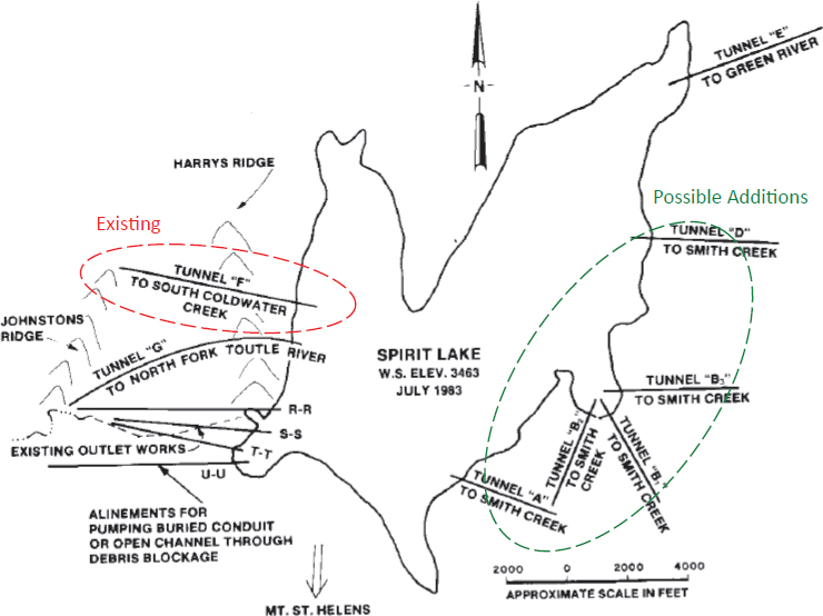
blockage, active geologic faults, and extensive surface erosion. A new tunnel could be located within competent bedrock with minimum faults and seismic effects. Since the difference in elevation between the lake water level and nearby streams or creeks east of Spirit Lake that drain into the Lewis River is about 1,200 feet (400 m), the tunnel could be gravity-fed, open-channel, or pressurized. The impact of routing water to the existing hydroelectric power reservoir system could be minimal, but it would need to be explored. If designed appropriately, the flow from the second tunnel could be used to generate electric power.
The second tunnel might remove nearly all risks of the identified potential failure modes in the proposed alternatives of the PFMA. If installed,
the existing tunnel could then be thoroughly rehabilitated without concern about uncontrolled rise in the lake level. It could also be possible to convert the Harry’s Ridge tunnel to a pressure tunnel or construct a lower intake level to allow for further lowering of the lake (as described earlier). Two working tunnels provide multifold flexibility in water routing, tunnel maintenance, lake water control, and sediment control. In the event of a potential eruption of the volcano, the water level in Spirit Lake could be drained to a desired state. The discharge of Spirit Lake water can go either southeastward or northwestward as needs dictate. The current Toutle River system will still exist, but with a discharge downstream of the Coldwater Creek confluence diminished by 300-400 cfs (8-11 m3/sec). The reduction in discharge could have negative impacts that would need to be explored. If the reductions were temporary until more natural flow patterns could be established, the long-term benefits might outweigh the short-term consequences. These are considerations that would have to be worked out through the decision-making process.
MANAGING SEDIMENTS
As described in Chapter 3, the USACE developed a 50-year plan to manage sediment associated with the 1980 eruption so as to maintain authorized flood risk levels along the Cowlitz River (USACE, 1985). Table 5.7 provides a timeline of events related to sediment management in the region. The USACE designed, built, and began operation of the 1,888-foot-long (575-m) and 184-foot-high (56-m) SRS on the North Fork Toutle River (see Figure 2.9) to capture medium- to coarse-grained sediments and allow finer particles to flow downstream in suspension to the Columbia River and out to sea.
The history of the SRS involves three phases (USACE, 1985). In Phase I (1989), sediments reached the level of the spillway, the pipe outlets were closed, and water began spilling over the spillway. Storage at this date was approximately 45 my3 (34.4 mm3). This followed expectations, more or less. The fine fraction of the sediment load (silt, clay, and sand finer than 0.125 mm) remains in suspension when it reaches the Cowlitz
TABLE 5.7 Timeline of Events and Sediment Management Actions by the USACE with Respect to the SRS from 1980 to Present
| Year | Event or USACE Action |
|---|---|
| 1980 | Eruption—More than 3 billion cubic yards of material displaced |
| 1980-1983 | Emergency responses |
| 1985 | Decision document finalized (original plan laid out) |
| 1989 | Sediment Retention Structure constructed |
| 1993 | Fish Collection Facility operated/maintained by State |
| 1998 | Top (and last) row of pipes closed at the SRS |
| 2005 | Cowlitz River sediment build-up at mouth; increased flood risk |
| 2007-2009 | Dredging in Cowlitz River at mouth |
| 2009 | Castle Rock Levee Cut-Off Wall |
| 2010 | Pilot Grade Building Structures constructed |
| 2012 | SRS Spillway Crest raised |
| 2010-2015 | Update to Long Term Plan with final draft SEIS |
| 2016 | Draft Biological Opinion received |
SOURCE: Kuhn and Sclafani, 2016.
River and is flushed to the Columbia River. In Phase II (1998), a wedge of additional storage formed at low gradient on top of the Phase I sediment plain. Storage in this wedge was approximately 145 my3 (110 mm3). An increasing percentage of larger sediment fractions washed over the spillway and was transported downstream. In the 2010s, grade building structures were placed in the sediment plain to encourage the development of the wedge. In Phase III, upstream bed becomes coarser as more sand fraction is washed over the spillway, and the slope of the plain steepens. Phase III storage is an additional approximately 68 my3 (52 mm3) (USACE, 2012).
By 2007, 4 to 5 million tons of sand had been transported from the Toutle River valley into the Cowlitz River (Biedenharn Group, 2010), where sand tends to settle and reduce flood conveyance capacity. This sand supply will increase in high-flood years and whenever the sediment fill approaches the spillway elevation. In 2006, it was concluded that flood protection provided by the levees along the lower Cowlitz River had been
degraded by these sedimentation processes (USACE, 2006). To respond to its commitment to provide certain levels of flood protection to the communities in the Cowlitz River floodplain (see Table 4.1) the USACE dredged the mouth of the Cowlitz River channel in 2007-2009 and improved the Castle Rock levee. In the absence of dredging, the observed trend of diminishing channel capacity was expected to continue and spread upstream, further reducing protection levels (USACE, 2006). Evaluation of such a plan required a new evaluation of the likely trajectory of sediment supplies from the Toutle River valley.
The strategies adopted for reducing impacts of this sediment load on downstream channel stability and flood conveyance capacity have included temporary check dam structures to capture a portion of the sediment within the North Fork Toutle River valley, raising and strengthening engineered flood levees along the lower Cowlitz River, and dredging the lower Cowlitz River to maintain navigation and flood conveyance capacity as necessary.
Sediment Budget and Management of the SRS
The flow of sediments into the SRS since 1980 is shown in Figure 5.3. Sediment flow may be slowing; but, based on communication with technical experts during the course of the study, that conclusion does not seem unanimous. Projections of future sediment yield have been lowered (Kuhn and Sclafani, 2016). The annual mean rate of sediment accumulation behind the structure is about 5 million cubic yards (3.8 million m3), but there have been spikes up to 20 million cubic yards (15 million m3). Large volumes of sediment are still expected to move off the Mount St. Helens debris avalanche for many years, and sediment deposition in the lower Cowlitz River remains a concern (USACE, 2014). About 80% of the volume of sediments accumulated to date originates in the debris avalanche.
Many uncertainties affect management decisions with respect to the SRS. The first is the future sediment yield off the debris avalanche. The sediment yield is related to volcanic activity at the mountain, but it is also related to hydrologic events. Conclusions from recent scientific studies vary: some predict persistently high sediment loads (Major, 2004;
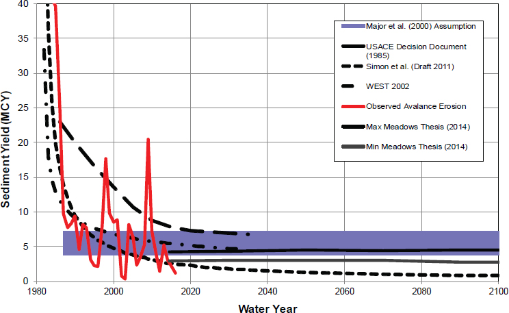
Meadows, 2014), while others predict a reduction of the loads (Simon and Klimetz, 2012).
Based on these studies, the USACE reevaluated management options for sediment control for the authorized planning horizon to 2035 (USACE, 2010a). The analysis confronted two contrasting projections: one argued that sediment supplies are declining (Simon, 1999; Simon and Klimetz, 2011); the other argued that there is no evidence that sediment supplies are declining (Major, 2004; Grant et al., 2016a). Direct measurement of sediment loads throughout the post-eruption period led Major (2004) to conclude that “persistent, extraordinary suspended sediment yields from severely disturbed channels indicate that mobile supplies of sediment remain accessible, and those supplies likely will not be exhausted for many more years or possibly decades.” A more recent review of empirical records to 2009 supports a similar conclusion (Grant et al., 2016a).
The USACE commissioned a new study of the post-eruption sediment budget of the Toutle-Cowlitz river system with projections of sediment loads
to 2035 (Biedenharn et al., 2010; Biedenharn Group, 2010). This study, the most thorough and multifaceted one to date, was based on a combination of post-eruption records of both erosion and sediment transport and on empirically calibrated hydraulic and statistical modeling. It separated the behavior of different grain sizes of sediment, which is important for assessing which sediment escapes from the SRS and which settles in the Cowlitz River channel.
The Biedenharn Group (2010: 149) concluded that evidence for a decline in the rate of debris-avalanche erosion over the past 20 years is not a sufficiently reliable base from which to project into the future. They estimated that the most likely sediment loading from the avalanche deposit by 2035 was 233 million tons (± 25-40%); they further estimated that after the SRS filled to the spillway elevation in 1998, approximately 80% of the sediment supply to the Toutle River mouth consisted of output from the SRS, with the South Fork Toutle River catchment providing another 13%. The study also concluded that between 2008 and 2035, with no changes made to the SRS, the most likely sediment load at the Toutle River mouth was 173 million tons—but with a range from about half to two times that value and a more likely uncertainty range of about one-third (Biedenharn Group, 2010). These projections assume no volcanic-, seismic-, or extreme-weather-related disruptions of the watershed.
These and other forms of evidence collected in their own sediment budget investigation led the USACE (2011) to adopt the more conservative interpretation of future sedimentation outcomes and to design an adaptive approach to managing the sedimentation risk for the remainder of the planning period to 2035. The adaptive management plan (USACE, 2014) involved three components: (1) A two-stage elevation of the spillway of the SRS, which would minimize cost and include the second increment only if necessary before 2035. The new spillway heights would be 7 feet (2.1 m) (completed in 2015) and then as high as 23 feet (7 m) as necessary above the original level. (2) Adaptable, incremental installation of grade building structures to increase flow length and resistance in the sediment plain upstream of the SRS to reduce transport capacity and increase deposition. (3) Continued dredging of the lower Cowlitz River channel as needed.
The reduction in spillway capacity caused by raising the spillway was considered conservative because: First, any conceivable mudflow that might be generated by a breakout of Castle Lake, or from a volcanic event in the Mount St. Helens crater, would result mainly in deposition upstream of the spillway and not tax the spillway capacity (Denlinger, 2011). But the current spillway would not accommodate a Spirit Lake breakout. Second, a reevaluation of the PMF for the location, based on updated methodology and gauged information, reduced the PMF by almost 50% (USACE, 2011).
The seismic behavior of the SRS and the sediment plain it retains is also uncertain. The peak ground acceleration associated with a maximum considered earthquake (MCE) as used in design is 0.61g (Britton et al., 2016a). This is relatively large. Assuming the sediment plain liquefies during this earthquake, the embankment is computed to have a factor of safety against instability of FS=1.3 (Britton et al., 2016a). That means that the resistance of the SRS structure to the loads imposed on it in such an event are 30% greater than the loads; thus, the SRS is considered stable under earthquake loading—even if the impounded sediments lose their strength (liquefy) during the event.
With the filling of the SRS to the spillway, larger grain size sediment is again flowing down the Toutle River. Without action, the USACE estimates that 20 to 70 million cubic yards (15 to 54 million m3) of sediment will flow into the Cowlitz River by 2035 (Stepankowsky, 2009), some of which will accumulate there. As a point of reference, the corresponding total load after the 1980 eruption was about 30 million cubic yards (23 million m3). Intensive dredging was required in the Cowlitz and Columbia Rivers as a result.
The USACE is considering four alternatives for future flood risk management in the Cowlitz River sediment plain in the wake of the spillway rise in 2012. These are described in detail in USACE (2014) and are only listed here:
- No action to manage sediment and maintain the established levels of protection (LOPs).
- Lower Cowlitz River dredging only.
- Raise the SRS spillway one time by 43 feet (13 m) and the SRS dam by 30 feet (10 m) without additional dredging.
- Phased construction with two incremental raises of the SRS spillway totaling 23 feet, additional grade building structures in the sediment plain, with dredging as needed.
The USACE identified this alternative as its preferred and recommended plan.
The USACE (2014) indicates that the preferred alternative would have major adverse effects on fish in the upper North Fork Toutle River area. Sediment deposition in fish habitat and a temporary rise in water temperatures would result from post-construction water impoundment. Mitigation would be implemented, but the current preferred alternative of a spillway raise does not include a mechanism for fish passage. A summary of information needs with respect to the SRS is shown in Table 5.8.
TABLE 5.8 Information Needs Related to the SRS
| Type | Description | Justification |
|---|---|---|
| Engineering characterization of the sediments | A detailed investigation is needed to evaluate the engineering properties of the SRS sediments, including strength, stiffness, and shear wave velocity. | No information is currently available on these sediments to evaluate their engineering behavior during a seismic event. |
| Site-specific seismic hazard analysis | A detailed seismic hazard analysis, including estimates of fault rupture and ground motion shaking, is needed as part of the rehabilitation of the existing outlet tunnel. | Generic data on seismicity in the region is insufficient for engineering evaluation of the SRS. |
MANAGING CHRONIC FLOOD RISK
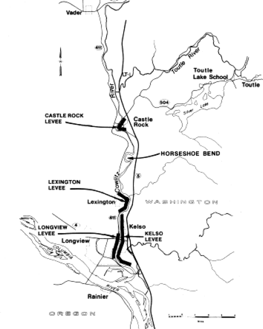
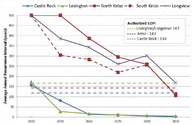
As has been described, the lower Toutle River and the lower Cowlitz River floodplain are subject to chronic flooding from the Toutle River as a result of the increased sediment in the river channels. For example, in the flood of February 8, 1996, the Toutle River watershed (drainage area 496 square miles [1,285 km2]) contributed 61,800 cfs (1,750 m3/sec) of the 112,000 cfs (3,171 m3/sec) peak flow passing the Castle Rock gauge on the reservoir-regulated Cowlitz River (drainage area 2,238 square miles [5,796 km2]) on the same day (USACE, 2014). Flows from the upper Cowlitz River north of the confluence of the Toutle and Cowlitz Rivers are mostly controlled by the Mayfield and Mossyrock Dams operated by Tacoma Power. The current levels of authorized flood risk reduction in the lower Cowlitz River, for which the levee system is sized, are listed in Table 4.1. These are provided by levee projects at Castle Rock, Lexington, Kelso, and Longview, the locations of which are shown in Figure 5.4. The authorities for these LOPs are granted in P.L. 99-88 (1985) and are specifically to “provide flood protection for developed areas along the Cowlitz River and navigation on the lower Columbia and Cowlitz Rivers”; they are likewise granted in Section 339, Water Resources Development Act of 2000,1 which “clarified that the [USACE] maintain levels of flood protection specified in 1985 Decision Document.” The river channels that drain the Mount St. Helens area consist of broad alluvial reaches with moderate to low gradients (0.005 to 0.03), whereas the gradient in the lower Cowlitz River drops to 0.0008 (Janda et al., 1984), which can contribute to sediment deposition and flooding. With time, LOPs in the lower Cowlitz River will decrease due to this settlement accumulation (see Figure 5.5).
Four possible engineering solutions were considered by the USACE to manage sediments (and therefore chronic flooding) in the Toutle and Cowlitz Rivers. There are other engineering and nonengineering
___________________
1 P.L. 106-541.
alternatives2 for flood-risk reduction in the lower Cowlitz River floodplain that are not considered in current planning and that are not necessarily mutually exclusive. They might involve, for example, creating a wider floodplain by removing structures and creating levee crevasses or reoperation of Mossyrock Dam, which feeds water to the upper Cowlitz
___________________
2 Some nonengineering solutions might include restricting new development to the current 500-year (p=0.002) floodplain or expanding the purchase of flood insurance or enhancing emergency management plans for both routine and catastrophic events. These and other nonengineering solutions could be done in lieu of or in concert with engineered solutions. Chapter 7 provides guidance on how alternatives with combinations of structural and nonstructural solutions can be compared.
River. Interim actions to address current sediment management requirements to maintain flood damage reduction benefits while the long-term sediment management plan is updated have been undertaken.
Flood Levees
The levees originally were built using a range of materials, some poorly suited to levee construction and having the corresponding impacts on stability and protection that would be expected under such circumstances. LOPs are variable. The levees have been improved several times, including nonengineered and temporary improvements. In 2010, the USACE evaluated whether the safe water levels (SWLs) for the levees were below
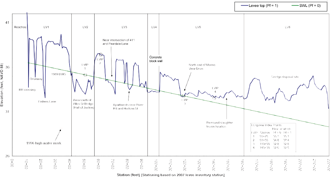
authorized LOPs. The SWL is the highest flood that the levee can reliably withstand without geotechnical distress or overtopping. Based on this analysis, the USACE determined that LOPs were met for the North Kelso and Longview levees, but were below authorized levels for Castle Rock, Lexington, and South Kelso (USACE, 2010b). Levee heights are variable and dip below the SWL at multiple locations (see Figure 5.6). The determination that the Longview levee meets the LOP is based on an assumption that the diking district can temporarily raise the levee to meet the LOP during high-water events. It is worth noting, however, that all levee heights are above the 1996 flood elevation.
At the lower Kelso levee, the SWL was lowered by the USACE because seepage on the landward slope can lead to sloughing of the cohesionless sand that forms the foundation of the levee (USACE, 2010c). Material below the Castle Rock levee ranged from “well to poorly graded sand, with silt or gravel, and occasional clayey sand. The compactness of the foundation soil ranges from loose to very dense” (USACE, 2010b). Conversely, the SWL was lowered on some levees (i.e., Kelso levee south of Olive Street) because dredge spoils had been removed from the riverside of the levee, which could lead to seepage during high-water events. Thus, the geotechnical stability of the levees is variable and dependent on the local diking districts managing the levees during high-water periods.
The Lexington and Castle Rock levees are particularly vulnerable to the flooding impacts associated with sediment loads. Since these are areas where losses are lowest from a regional perspective, however, the analysis of viability of nonstructural alternatives, such as relocating these communities, may be inadequate. Similarly, analysis of the combinations of structural and nonstructural alternatives has not, to the knowledge of the study committee, been conducted. As stated in the USACE external review of the Sediment Management Plan, “the effectiveness of the final array of alternatives in addressing sediment transport beyond the year 2035 could potentially show different economic and environmental results than if only the period until 2035 was considered. This could alter the selection of the recommended plan” (Batelle, 2014).
The transport of sediment, including debris flow events, from the Mount St. Helens area can significantly increase the flood hazards. Debris flows are initiated by mobilization of landslides, volcanic melting of snow-pack, and flood surges, with the most damaging flood events associated with the entrainment of sediment during large flood surges (Major et al., 2005). The USACE has yet to forecast how much future sediment buildup would reduce flood risk protection in the Cowlitz River, although interim actions as noted above have been undertaken. A cut-off wall was also added to the levee reaches in Castle Rock to alleviate potentially destabilizing underseepage. The principal uncertainties have to do with the volume and timing of future sediment releases over the SRS and the consequent amount of bed elevation in the Cowlitz River channel, especially in the vicinity of the three riparian municipalities.
Information needs with respect to flood risk reduction in the lower Cowlitz River are more modest than are those with respect to other aspects of the management of the system. The main uncertainties that require better information are those related to the potential for nonstructural strategies of a flood risk reduction and those related to the rate of future sediment accumulation in the lower Cowlitz. A summary of information needs with respect to the levees and flood risk reduction is shown in Table 5.9.
SHORT- AND LONG-TERM MANAGEMENT
Although authorization for management of various elements of the Spirit Lake and Toutle River system extend through 2035, the need for active risk management of the Spirit Lake and Toutle River system does not end at some arbitrarily authorized date. Management decisions need to be planned with a long-term perspective, irrespective of the vagaries of current political pressures. Agreeing on a management time horizon, however, needs to be done in the context of a decision protocol because the interests and needs of different interested and affected parties may only be met given specific time frames. Identifying a time horizon may result in institutional and social conflict given the different strategies that might be required for
TABLE 5.9 Information Needs Related to Levees and Flood Risk Reduction
| Type | Description | Justification |
|---|---|---|
| Evaluation of nonstructural strategies for reducing flood losses | Data and analyses supporting nonstructural strategies, including relocating communities, is lacking. | Information needed to judge whether nonstructural solutions are viable is not now available. Nonstructural solutions alone or in combination with structural solutions might provide optimal alternatives to management. |
| Evaluation of future sediment accumulation | The USACE has yet to forecast how much future sediment buildup would reduce flood risk protection in the Cowlitz River, although interim actions have been undertaken. | The principal uncertainties have to do with the volume and timing of future sediment releases over the SRS and the consequent amount of bed elevation in the Cowlitz River channel, especially in the vicinity of the three riparian municipalities. |
the different time frames. Factors affecting the choice of time frame are discussed in Chapter 6.
Recommendation: Alternatives for managing the Spirit Lake and Toutle River system should be judged over both short and long time frames to ensure consideration of the range of the concerns of interested and affected parties.
Engineered elements such as the tunnel, the SRS, and levees are part of the Spirit Lake and Toutle River system and have a finite engineering design life. The choice of time frame for risk management decisions related to their design, construction, and management is critical and therefore must be explicit. Legislated time frames, however, such as the 50-year open construction period for the SRS—typical for many infrastructure
projects—may preclude consideration of system management activities such as restoration. Choosing among alternatives given consideration of management over a single time frame may limit flexibility in management over the long term and may, in fact, increase long-term costs. Furthermore, the longer-term risks and financial burdens left unaddressed in a given time frame will become the responsibility of future residents and taxpayers. Active assessment of alternatives given multiple time frames can inform the selection of both the most appropriate alternatives and the time frames given the impacts and trade-offs associated with either.
OPERATIONAL RISK
The evolving landscape of the Spirit Lake and Toutle River region is now dominated by the engineering conducted within it since the 1980 eruption of Mount St. Helens. The engineered landscape was originally created to protect those living in the Toutle and Cowlitz River basins from natural hazards resulting from the eruption, but that engineering has had large-scale and important effects on the ecology, geomorphology, and landscape values of the region. Federal, state, and local responsibilities for managing this system are inevitably complex, expensive, and indefinite. Engineering needs to adapt to both the evolving natural environment and the preferences and needs of interested and affected parties. Any thought of a natural, unmanaged environment is unrealistic.
The engineering itself introduces risk beyond those caused by natural events. Such risks are caused by the operation of the engineered facilities; historically, operational risks to, for example, dam safety may be large (Leveson, 2011; Hartford et al., 2016). Operational risks may result by policy and procedures, by instrumentation and supervisory control and data acquisition (SCADA) systems, by inaccessibility to the site at a time of urgency, by human errors, or by many other factors (Leveson, 2011). Operational risks in a complex system such as the engineered landscape of the Spirit Lake and Toutle River region may exceed risks due to natural hazards, engineering design, or other factors that more commonly appear in risk assessments (Regan, 2010).
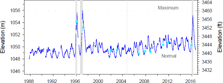
Large rises in Spirit Lake water levels have been associated with periods of extended tunnel closure for maintenance or repair (Grant et al., 2016a), for example, as in 1996 and 2016 (see Figure 5.7). The associated hazard is that if the tunnel remains closed, lake levels may rise uncontrollably. Even though precautions are taken to prevent such an operational risk, the risk still exists. The possibility of a dramatic and quick rise in lake levels during tunnel closure has led to an operational bias of avoiding tunnel closure more than was necessary. Occupational safety and health risks may also be introduced by operational factors. Access to the tunnel intake for management activities (including opening and closing the gates and wood removal), for example, can be dangerous, particularly during bad weather in winter months. This concern was voiced by USFS personnel to study committee members during the committee’s open session meetings. It is necessary to recognize operational risk explicitly when considering engineering reliability; thus, operational risks to personnel (or decisions that reduce that risk) need to be considered as part of the final decision-making framework.
Operational risks arise in many aspects of the risk management plan for the Spirit Lake and Toutle River system. This is true irrespective of the drainage alternative used for the lake—be it a tunnel, surface channel, conduit, or pumping—or for any infrastructure put in place in the system. All of these involve operations and consequently operational risk, although the levels of operational risk associated with the various alternatives are not all the same. They all involve the vagaries of weather, human operators, sensors, SCADA systems, and other practical factors. It may be that the larger risks posed by the system derive from these operational factors rather than from natural hazards and extreme events alone (Hartford et al., 2016). Given that the Spirit Lake and Toutle River system is an engineered system, it needs to be managed and operated by a cognizant authority. As such, the risks that attend it arise not only from natural hazards but also from the human operations that direct it.
Recommendation: Operational risk should be explicitly considered when evaluating alternatives for management.
INTEGRATION USING PROBABILISTIC RISK ASSESSMENT
The effectiveness of the engineered landscape is today commonly appraised by the use of a probabilistic risk assessment, or PRA. This approach is common to most modern infrastructure studies as well as to the evaluation of natural and technogenic hazard mitigation: for example, as applied to dam and levee infrastructure (see NRC, 2012b). Modern approaches to risk management are increasingly based on PRAs that address the capability of a system to withstand extreme loads. A PRA is especially useful in appraising design and rehabilitation decisions and which design loads and corresponding factors of safety must be chosen. Assessing operational risk involves considering the vagaries of weather, human operators, sensors, SCADA systems, and other operational factors. It may be that the significant risks posed by the system derive from these operational factors rather than from natural hazards and extreme events alone.
The incorporation of natural hazard risks in a decision framework is now common in public policy planning and infrastructure risk management. The uncertain occurrence of hydrologic, volcanic, and seismic hazard events in the Spirit Lake and Toutle River region is typically described in annual exceedance probability curves of their magnitude. Operational risks as discussed above are also important to infrastructure risk management. A PRA provides the platform for integrating the many hazards affecting the Spirit Lake and Toutle River system and for combining those hazards and their potential consequences within a formal decision protocol as discussed in Chapters 6-8. Without a quantitative analysis of these risks it is not possible to balance the opportunities and investments to achieve the most advantageous outcomes. The implementation of a PRA for the Spirit Lake and Toutle River system is not difficult given the current level of understanding of the system, the history of evidence-based analysis of the natural conditions of the basin, and the foundation of data already acquired. Methods of conducting a PRA in common practice in such closely related fields of science and engineering as volcanology, civil engineering, and actuarial science provide a well-exercised basis for applying this methodology.
Probabilistic Risk Asessment
A PRA is a systematic approach to evaluating risks associated with complex engineered systems such as the Spirit Lake and Toutle River system. A PRA addresses the types and magnitudes of hazardous events that might load a system, the performance of that system under these loads, and corresponding adverse consequences that might result. A PRA is an essential component of modern public policy decision making, especially in the context of complex engineered infrastructure (Yohe, 2010) and is a necessary input to the decision framework of Chapters 6-8. The decision framework recommended in this report cannot be fully leveraged without a quantitative understanding of the risks presented in the system.
The common modern convention for a PRA in closely related fields is the threat-vulnerability-consequence (TVC) model, shown schematically in Figure 5.8. “Threat” (or hazard) is quantified in the probability
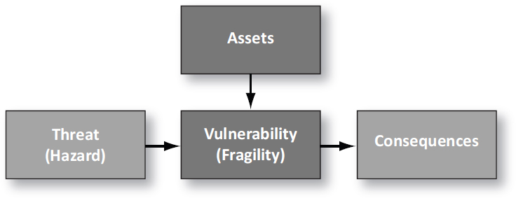
of load events occurring against the system. “Threat” is a term commonly associated with man-made or malicious actions, while “hazard” is a term commonly associated with natural processes, as in the case of the Spirit Lake and Toutle River system. “Vulnerability” is the expected performance or damage to the system given a load event of certain description. In structural, earthquake, geotechnical, and dam safety engineering, vulnerability is usually replaced by the term “fragility,” which is the conditional probability of adverse performance (e.g., failure) of the system given a load event of certain description. “Consequences” are typically quantified in economic costs, environmental impacts, and loss of life.
A hazard in the present context is any real or potential element that may result in adverse performance of the system leading to undesirable consequences. Hazards are identified by historical review of past events, by functional analysis of modes in which a system can fail (e.g., PFMA), or by expert appraisal (Kumamoto and Henley, 1996). In some applications, design and construction flaws are also treated as hazards, but that is outside the normal TVC paradigm. Those who will use the results of any PRA for decision making will need to be involved in deciding how such factors should be counted in the PRA. The vulnerability of a system is the damage expected for a given hazard load. The fragility is the chance of failure or adverse performance for a given hazard load. The concepts are related, and
for the most part, the terms are used in similar ways. Both vulnerabilities and fragility curves can be assessed in the normal engineering ways: from empirical data, modeling, or expert judgment (Rossetto et al., 2014).
The chance of hazardous events occurring is expressed probabilistically. The aggregate risk is calculated as expected loss, that is, the sum-product of the probabilities of the prospective hazards and their corresponding consequences. These probabilities and consequences—the aggregate risk—serve as necessary input to the application of the decision framework discussed in Chapters 6-8.
Adequacy of the Current Risk Analysis
The decision framework outlined in Chapters 6-8 is predicated on a quantitative assessment of the hazards, vulnerabilities, and consequences attending infrastructure decisions and the management of risk in the Spirit Lake and Toutle River system. This is not now available in a comprehensive form. A well-intentioned and competent precursor of a quantitative risk analysis was performed in the context of the PFMA of the Spirit Lake drainage situation. This PFMA provides a journeyman analysis of the potential failure modes associated with each alternative drainage option for the lake. It provides a firm foundation for a PRA. It does not go sufficiently far, however, to associate probabilities and potential consequences with the respective failure modes. This will be needed among a more extensive analysis for the risks associated with the lake, its drainage, and other issues to be fully understood. Such a quantitative risk analysis is recommended for fully leveraging the decision framework of Chapters 6-8.
The probabilities of the major natural hazards affecting the system—hydrologic, seismic, and volcanic—may be known imperfectly or qualitatively, but they are characterized to some extent. Probabilities associated with the vulnerabilities of the built environment, specifically the drainage alternatives for Spirit Lake and the performance of the SRS, have not been evaluated. The same is true in large part for the quantification of the downstream consequences of these hazards. Thus, for the present, a quantified understanding of risk is not available.
A PRA seeks to assess hazards, performance, and consequences in quantified units of probability and cost. Probabilities express how likely something adverse is to happen; costs express consequences in dollars, lives, and environmental measures. The PRA answers three questions (Kaplan and Garrick, 1981): (1) What can happen? (i.e., What can go wrong?); (2) How likely is it that it will happen? and (3) If it does happen, what are the consequences?
Event Tree Representations as Information for the Decision Framework
Event trees are now commonly used to represent the components of a PRA for civil infrastructure systems, particularly for dam and levee safety (USBR and USACE, 2012). They have also been widely used to analyze risks associated with volcanology. The USACE has been a pioneer in the application of PRA methods to civil infrastructure systems, particularly to issues in water resources engineering. Thus, the expertise for such studies is demonstratively available and straightforward to apply, and there is extensive documentation of such applications to similar natural systems involving volcanology, seismology, and dam safety reported in the literature. This device may be used for any of the hazards discussed above—particularly to integrate these hazards within a common framework.
Construction of event trees involves establishing probabilities for the various uncertain events that might affect the system. For instance, given an eruption with its associated annual probability, what is the probability of a pyroclastic flow of a certain volume, and if it occurred, what damage might it cause? Such probabilities can be based on events from the historical or geologic record; on additional data, such as geophysical imaging of the volcano’s plumbing; on numerical models of specific processes; or on expert opinion elicitation (O’Hagan et al., 2006). Expert judgment can be obtained through the work of individual scientists or small teams of scientists, or from a formal expert elicitation process wherein a panel representing a diverse range of expertise is provided with all relevant information (e.g., Aspinall, 2006; Coppersmith et al., 2009).
The event tree in Figure 5.9 is a simple example of a generic volcanic hazard. Moving from left to right, first the probability of a given eruption scenario occurring during the time frame of concern is specified. Then the probabilities of particular eruption phenomena that might be associated with that scenario are assigned, followed by probabilities of particular magnitudes (such as lahar volume). This approach can be carried forward to include vulnerabilities and consequences of any type in the Spirit Lake and Toutle River system. An important first step in any analysis is defining the time frame of interest (e.g., a design lifetime of the SRS), and, in the case of this example, the eruption scenarios of interest. Note that the time frame of interest needs to account for the interests of all interested and affected parties involved in decision making. Choosing the time frame is best done in a collaborative analytic process that includes stakeholders, as is discussed in Chapter 6.
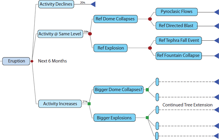
An event tree is simply a systematic way to organize and describe the possible outcomes of a hazard and its consequences. It is an input to the decision framework in Chapters 6-8. Event trees represent the possible outcomes of a random process. At each node in the event tree the emanating events are appraised as mutually exclusive and collectively exhaustive, so their respective probabilities add up to 1.0. Assessing the consequences of future natural hazards requires integration of our understanding of potential hazards, as discussed above, and engineering aspects of the debris blockage, the Spirit Lake tunnel or other drainage scheme, and the SRS. The consequences downstream can be estimated in measures deemed important through the decision framework (see Chapter 6), including impacts on environmental health, fish populations, and sociological factors. The probability-weighted consequences provide a quantitative measure of risk and its uncertainty.
LEVERAGING RESOURCES AND EXPERTISE
The study committee has noticed an apparent insularity of expertise among those involved in management of elements of the Spirit Lake and Toutle River system. Whereas great expertise resides within those agencies, relying almost solely on that expertise can stifle the generation of new ideas and can result in a propagation of assumptions based on incomplete assumptions. The federal and state agencies involved in managing the system have a number of resources available to them from other parts of their respective organizations. For example, the USACE operates a Risk Management Center for dam and levee safety, which could be leveraged to a much greater extent in the future than it has been in the past. Similarly, the USFS and the USGS have agency resources that might be more fully brought to bear on the planning for Spirit Lake and the Toutle River. The mobilization of these important resources needs to be encouraged throughout analytic processes, the results of which inform decision making. Likewise, external review of analytical processes needs to be encouraged to identify how and where analysis might be strengthened.


