
Linking Remote Sensing and Field-Based Measurements
Isla Myers-Smith discussed the effectiveness of remote sensing techniques in capturing field-scale observations at her research site at Qiqiktaruk, Herschel Island, Canada, and across the circumpolar International Tundra Experiment (ITEX) sites. She framed this evaluation around her work on changes in tundra phenology, plant species cover (including increased shrub cover, or shrubification), and species traits (e.g., increased plant height).
For plant phenology, in-situ measurements collected between 1999-2017 showed that leaf greenup and senescence are both occurring earlier, resulting in no change in the growing season length (Myers-Smith et al., 2019a). This is inconsistent with MODIS data, which shows greenup occurring earlier and senescence later in more recent years, which would suggest an extension of the growing season. When compared with phenocam imagery, MODIS picks up a greening signal before plants are visually green and exhibits MaxNDVI just prior to senescence becoming visually apparent (Myers-Smith et al., 2019b). More broadly, field-based measurements at the ITEX sites are showing a range of phenological responses. Myers-Smith explained that many sites may not be showing earlier leaf emergence because of altered snow conditions (i.e., snow depth may be deeper than it was historically, resulting in melt out occurring around the same time it used to greenup, or perhaps even later). These ITEX site results have not yet been directly compared with remote sensing data.
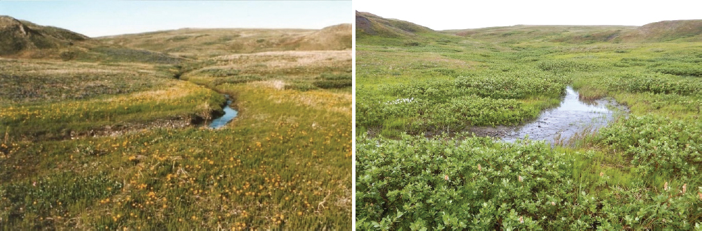
At Qiquiktaruk, a greening trend has been observed on the ground in association with an increase in plant cover, including shrubification, and a decrease in bare ground over time (1999-2017; Myers-Smith et al., 2019a). Many MODIS pixels pick up the greening trend; however, browning pixels are also observed and correspond to retrogressive thaw slumps on the landscape (Myers-Smith et al., 2019b). Across ITEX sites, an increase in plant cover and shrubification has also been observed at many-to-most sites, but this greening does not correspond to trends in NDVI (GIMMS) at those sites, which may be at least in part due to the differences in the scales at which the data were collected.
Evidence from the literature indicates greening trends at many sites where increases in shrubs have also been observed, suggesting that shrubification may drive greening (see Figure 7). Myers-Smith presented drone imagery from two rather contrasting sites; Qikiqtaruk, which exhibits relatively low landscape-level heterogeneity, increasing shrub cover, and variable radial growth; and Kangerlussuaq, Greenland, which shows high landscape-scale heterogeneity and increased yet stabilized shrub cover and variable radial growth (Myers-Smith et al., 2019b). Both sites show an increase in NDVI (although it is much more variable at Kangerlussuaq) as well as dramatic increases in shrub cover. However, there is not a strong correlation between interannual variability in shrub growth and interannual variability in NDVI. A similar lack of relationship was found across a broader range of sites. Myers-Smith indicated that these results demonstrate there is complexity that still needs to be disentangled when linking remote sensing and in situ records.
RECONCILING TRENDS ACROSS MEASUREMENT APPROACHES AND SCALES
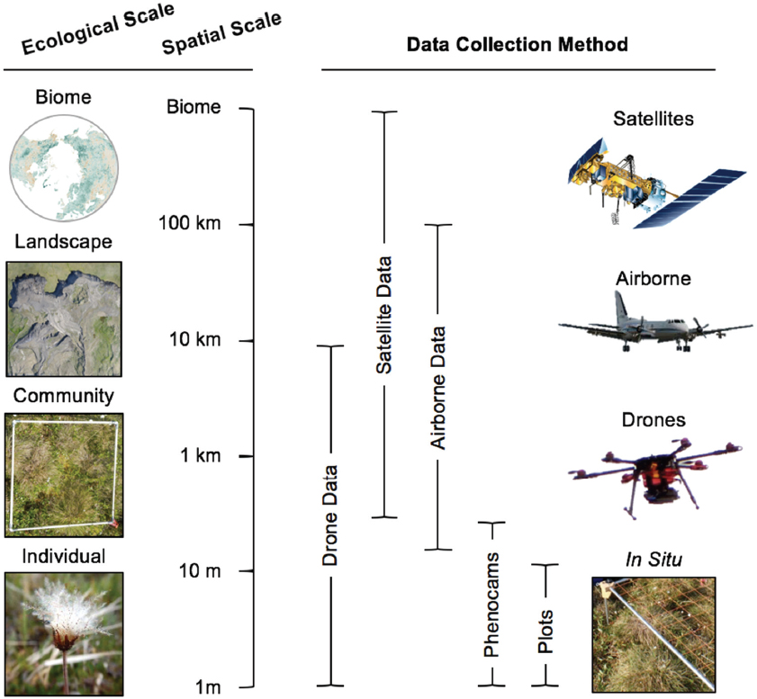
Most workshop participants agreed that moving toward increased collection of data at a finer scale and improved bridging of information across scales to address identified inconsistencies would help to
advance understanding of greening and browning trends and drivers (see Figure 8). There are now capabilities that allow for greater data fusion and expanded data exploration in terms of computing, archiving, and mining datasets. Time and again, the synergistic use of datasets have allowed researchers to learn more, and participants suggested that expanded leveraging of these resources could prove valuable. This more synergistic approach could also allow for the now common coarser-resolution analyses to be included as secondary efforts. It was also noted that researchers are no longer limited to working with a single satellite dataset and that multiple platforms can now be used together to derive trends, which could increase the robustness of presented results.
Agreement on common timescales to be used between remote sensing and field-based research communities was also discussed as a way to foster improved communication and understanding of vegetation change. An outstanding timescale question highlighted by participants was, “what time scales are appropriate for assessing changes in productivity, or for discrimination between longer-term systematic trends versus short-term events?” The use of common protocols as appropriate would also be beneficial, especially as networks expand and greater linkage between remote sensing and field-based measurements is encouraged. Additionally, providing context for the region of study is critical to interpreting patterns of change. This includes knowledge of disturbance history.
While tundra and boreal forest were discussed jointly at this meeting, these ecosystems have many unique properties that may benefit from distinctive observational and analytical methodologies. Indices like NDVI are differentially sensitive to processes across these ecosystems, and by treating the systems separately, researchers may be able to better differentiate mechanisms driving vegetation change. Certain types of data may also be of higher importance in one system or the other. For instance, structural data was discussed as being particularly important in boreal forests.
NDVI AS THE METRIC FOR EVALUATING GREENING AND BROWNING
NDVI information was included with remote sensing results presented throughout the workshop. While this metric was recognized to be an important indicator of greening and browning with a long satellite record that helps to allow for trend detection, it was generally noted to be a relatively simple metric that is limited in the information it can provide. Further, it can be difficult to relate or compare NDVI values to other metrics, including field-based measurements. Challenges to using NDVI that were discussed by workshop participants include:
- Differential sensitivity in NDVI in tundra versus boreal ecosystems. In much of the boreal forest, NDVI is close to saturation such that detecting a greening trend may be much more difficult than detecting browning.
- The high sensitivity of NDVI to surface wetness and soil moisture. This can lead to areas being misinterpreted as vegetation browning when the surface is wet, which influences the usability of some remote sensing information.
- The inability of NDVI (and many other common metrics of productivity) to account for belowground processes or allocation of resources for root growth, which can be important metrics for evaluating ecosystem-scale productivity.
Participants discussed expanding beyond the use of NDVI as a primary metric. This could include better utilization of available multispectral data and other time series datasets that could be integrated with newer technologies, microsatellites, richer datasets, new remote sensing, lidar, and radar instrumentation.
This page intentionally left blank.


