


Below is the uncorrected machine-read text of this chapter, intended to provide our own search engines and external engines with highly rich, chapter-representative searchable text of each book. Because it is UNCORRECTED material, please consider the following text as a useful but insufficient proxy for the authoritative book pages.
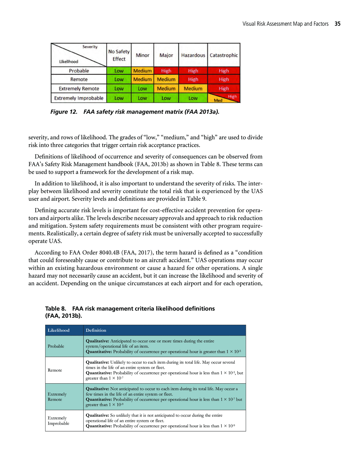
34 This chapter serves as a tool for developing visual risk assessment maps for airport operators. The method helps airport operators better understand and visualize geospatial risks that may exist in the context of UAS operations. Furthermore, this guidance helps airports with assess- ing risks as part of their risk management process. This chapter will describe the risk analy- sis approach (Section 4.1) and characterize the specific risk factors (Section 4.2). Using this approach and risk factors, Section 4.3 describes map elements and provides an example risk map. This tool can be used by airport operators to generate their own specific risk maps and improve risk management processes. The tool also helps provide a common framework for discussing risk among entities, working with airports to manage and communicate risks. 4.1 Tools and Methods for Map Development In this section, a method is described for map development using tools referred by FAA best practices and mitigation tools. The fundamentals of risk mitigations are introduced, as well as factors leading to risk area categorization, which will help airport operators identify risk areas and mitigation strategies specific to their airports. 4.1.1 Development of Risk Factors This section describes the approach to developing risk factors in the context of UAS opera- tions for airports by defining key concepts such as risk matrix, factors, and management. This includes a description of a method for augmenting the FAA SRM framework to incorporate UAS-related risks, leveraging literature from defense UAS programs and recent developments in commercial UAS testing and evaluation. 4.1.2 Defining Low-, Medium-, and High-Risk Areas Risk is described by likelihood and severity of an adverse event. While risk exists on a con- tinuum, risk management frameworks categorize risk into discrete levels that represent risk management regimes. Risk level is determined on a case-by-case basis through an analysis of a scenario. FAA has well-established risk management criteria to determine the level of risk for manned flight, which is described herein. However, for UAS, risk management criteria are currently less understood due to the relatively small amount of empirical evidence, as well as the dynamically changing nature of UAS operations as they are phased into the NAS, pro- liferate in number, advance in technology, and find new use-cases. This section identifies some common UAS risk criteria based on available information. Figure 12 shows FAAâs safety risk management matrix (FAA, 2013a) as a first consideration. As seen in the matrix, risk can be visualized as a table with columns that describe gradations of C H A P T E R 4 Visual Risk Assessment Map and Factors
Visual Risk Assessment Map and Factors 35 severity, and rows of likelihood. The grades of âlow,â âmedium,â and âhighâ are used to divide risk into three categories that trigger certain risk acceptance practices. Definitions of likelihood of occurrence and severity of consequences can be observed from FAAâs Safety Risk Management handbook (FAA, 2013b) as shown in Table 8. These terms can be used to support a framework for the development of a risk map. In addition to likelihood, it is also important to understand the severity of risks. The inter- play between likelihood and severity constitute the total risk that is experienced by the UAS user and airport. Severity levels and definitions are provided in Table 9. Defining accurate risk levels is important for cost-effective accident prevention for opera- tors and airports alike. The levels describe necessary approvals and approach to risk reduction and mitigation. System safety requirements must be consistent with other program require- ments. Realistically, a certain degree of safety risk must be universally accepted to successfully operate UAS. According to FAA Order 8040.4B (FAA, 2017), the term hazard is defined as a âcondition that could foreseeably cause or contribute to an aircraft accident.â UAS operations may occur within an existing hazardous environment or cause a hazard for other operations. A single hazard may not necessarily cause an accident, but it can increase the likelihood and severity of an accident. Depending on the unique circumstances at each airport and for each operation, Figure 12. FAA safety risk management matrix (FAA 2013a). Likelihood Definition Probable Qualitative: Anticipated to occur one or more times during the entire system/operational life of an item. Quantitative: Probability of occurrence per operational hour is greater than 1 Ã 10-5 Remote Qualitative: Unlikely to occur to each item during its total life. May occur several times in the life of an entire system or fleet. Quantitative: Probability of occurrence per operational hour is less than 1 Ã 10-5, but greater than 1 Ã 10-7 Extremely Remote Qualitative: Not anticipated to occur to each item during its total life. May occur a few times in the life of an entire system or fleet. Quantitative: Probability of occurrence per operational hour is less than 1 Ã 10-7 but greater than 1 Ã 10-9 Extremely Improbable Qualitative: So unlikely that it is not anticipated to occur during the entire operational life of an entire system or fleet. Quantitative: Probability of occurrence per operational hour is less than 1 Ã 10-9 Table 8. FAA risk management criteria likelihood definitions (FAA, 2013b).
36 Airports and Unmanned Aircraft Systems the defined risk may rank differently between low, medium, and high. Visual risk maps help understand hazards spatially, but not all hazards are easily represented visually. This chapter provides visual risk maps and describes hazards that are not easily visualized which can be used to define risk levels for specific scenarios. Considering the FAA Risk Management Framework and literature on UAS risks, guidance for assessing high (Figure 13), medium (Figure 14), and low (Figure 15) levels is described here. They are provided as examples for how risk could be assessed. Because each unique circumstance at an airport will alter the risk assessments, these should not be considered blanket definitions, but rather example guidelines. These figures include examples of risk criteria and scenarios that characterize high, medium, and low risk. The example risk criteria and scenarios were identified based on an analysis conducted by Bard College Center for the Study of the Drone on UAS inci- dent reports (Gettinger and Michel, 2015). The Bard analysis considers 921 incidents involving UAS from December 2013 to September 2015, and identifies common UAS sightings and close encounters. 4.2 Risk Factors Risk factors can stem from system, operational, and environmental conditions. UAS opera- tions around airports must consider the same risks as manned aircraft. New factors specific to UAS are defined in this section. While these factors are most directly applicable to UAS Severity Definition Catastrophic Results in multiple fatalities and/or loss of the system Hazardous Reduces the capability of the system or operator ability to cope with adverse conditions to the extent that there would be: Large reduction in safety margin or functional capability Crew physical distress/excessive workload such that operators cannot be relied upon to perform required tasks accurately or completely Serious or fatal injury to small number of occupants of aircraft (except operators) Fatal injury to ground personnel and/or general public Major Reduces the capability of the system or operator ability to cope with adverse operating conditions to the extent that there would be Significant reduction in safety margin or functional capability Significant increase in operator workload Conditions impairing operator efficiency or creating significant discomfort Physical distress to occupants of aircraft (except operator) including injuries Minor Does not significantly reduce system safety. Actions required by operators are well within their capabilities. Include: Slight reduction in safety margin or functional capabilities Slight increase in workload such as routine flight plan changes Some physical discomfort to occupants or aircraft (except operators) Minor occupational illness and/or minor environmental damage, and/or minor property damage No Safety Effect Has no effect on safety Major occupational illness and/or major environmental damage, and/or major property damage Table 9. FAA risk management criteria severity definitions.
Visual Risk Assessment Map and Factors 37 Figure 13. High-risk level definition based on FAA Order 8040.4B. Four examples of common risk criteria are given based on research by Bard College Center for the Study of the Drone on UAS incident reports. These criteria demonstrate when a scenario may be considered high risk (Gettinger and Michel, 2015). Figure 14. Medium-risk level definition based on FAA Order 8040.4B. Two examples of common risk criteria are given based on research by Bard College Center for the Study of the Drone on UAS incident reports. These criteria demonstrate when a scenario may be considered medium risk (Gettinger and Michel, 2015).
38 Airports and Unmanned Aircraft Systems operators, it is important for an airport operations department/manager to be familiar with them, especially as they relate to the management of UAS operations within the vicinity of existing manned aircraft around an airport. Table 10 describes risk factor definitions and guidance documents, which are based largely on information from the FAA Risk Management Handbook 8083-2, FAA Low Altitude Authorization and Notification Capability (LAANC), 14 CFR Part 77, Part 91, and Part 107; AC 60-22; and AC 150/5300-13A. 4.2.1 Operational Recognizing the risks associated with UAS operations near airports, FAA has developed spe- cific guidance based on airspace class and proximity to airports. Inside controlled airspace, spe- cial permission must be acquired via waiver from FAA. More than 90% of airports in the United States have no control tower (Air Safety Institute, 2017). Under Part 107, UAS operators are not required to coordinate operations with or give notice to airports in Class G (uncontrolled) airspace. Part 101-E recreational (i.e., Model Aircraft) users are only required to notify the airport and ATC (if a tower is present). Part 107 establishes a general rule for sUAS to avoid interference with manned aircraft but does not include a provi- sion recommending communication between aircraft, manned or unmanned, when approaching or departing from an uncontrolled airport. The FAA LAANC program is an automated process to issue airspace authorizations in near real-time for operations in controlled airspace. System integrity and capability are critical in maintaining navigation, separation, and geospatial restric- tions of UAS operations. Compromised system integrity could lead to hazardous risks, such as collision with a manned aircraft or people on the ground. UAS airworthiness and system integ- rity must constantly be checked and repaired for any operation to take place safely. Operational factors can be challenging to depict geospatially, as they often relate to specific technology that is either onboard the vehicle or infrastructure provided by the airport and ATC. Figure 15. Low-risk level definition based on FAA Order 8040.4B. Two examples of common risk criteria are given based on research by Bard College Center for the Study of the Drone on UAS incident reports. These criteria demonstrate when a scenario may be considered low risk (Gettinger and Michel, 2015).
Visual Risk Assessment Map and Factors 39 These capabilities can reduce the risks generated by certain UAS operations based on consid- erations such as range and performance of communications, perception systems, and aircraft (e.g., in a lost link scenario). 4.2.2 Pilot in Command PIC risk factors are described in AC 60-22, Part 107, and Part 77. These include safe/efficient use, preservation of navigable airspace, capability, coordination, and aptitude. As the person in control of the UAS, the PIC must adhere to the Aeronautical Decision Making best practices (FAA 2017a). The PIC is directly responsible for maintaining the flight path of the UAS and coordinating with airports before and during operations. The PIC must also coordinate with a avoid airspace and demonstrate a secure operational reliability Tracking and Identification Tracking and ID systems can be ground- based (e.g., radar) or part of the UAS (e.g., lighting or ADS-B) AC 150/5300-13A: Airport Design Criteria Operator Capability PIC complies to Aeronautical Decision Making best practices AC 60-22 Pilot in Command Coordination with Airports PIC complies with airport operations and recognizes critical pathways (e.g., runway approach and departure paths) to avoid Part 107; Part 77; AC 150/5300-13A Operator Aptitude Operator must hold a remote pilot airman certificate and demonstrate proficiency in operations Part 107 Weather Weather conditions during operations are dealt with in a reasonable manner; PIC must react accordingly to weather forecasts and communicate with airports under conditions AC 60-22; Part 91 Environment Terrain Feature Nearby terrain feature that influences flight plan (e.g., spot elevation, body of water, or man-made road) AC 60-22 Local Infrastructure Nearby buildings or sites; special permissions required when performing on-site operations within airports AC 60-22; AC 150/5300- 13A Other Hazards External factors not present during flight plan or initial operation (e.g., TFR) AC 60-22 Category Risk Factor Definition Data Sources Operational Factors Separation Separation may be achieved by reserving airspace, IFR/VFR Part 77: Standards and notification requirements for objects affecting navigable airspace Aircraft Capability Aircraft complies with weight, payload, and airworthiness requirements Part 107 Line of Sight Operation is conducted in VLOS or extended/BVLOS with proper waivers or exemptions Part 107 System Integrity System and operations comply using geofencing or waypoint navigation to AC 60-22 Table 10. Risk factor definitions by category.
40 Airports and Unmanned Aircraft Systems designated visual observer when conducting certain operations. A PIC operating under Part 107 must maintain a remote pilot airman certificate to demonstrate that they are a competent and knowledgeable pilot. Additional training may be appropriate based on the specific operation. In its current state, risk levels for PIC are challenging to illustrate in a Geospatial Risk Map as it directly relates to the PICâs aptitude and merit. 4.2.3 Environment An analysis and review of several FAA aviation documents, most notably AC 60-22, AC 150/ 5300-13A, and Part 91 revealed many potential environmental factors to include on the UAS Risk Map. A prominent environmental risk factor is weather, which is a dynamic and localized factor that can quickly change operating risks in specific areas. High winds, precipitation, or icing conditions may be cause to alter or cease UAS operations or employ mitigation strate- gies. Concerns surrounding weather focus on both universal risks, such as precipitation or high barometric pressure, as well as those faced by only some airports, like coastal fog or strong cross winds. A secondary environmental risk that can be visualized on a risk map is local infrastructure. Runways and taxiways within airports prove to be high-risk areas, especially if UAS operations occur concurrently with manned aircraft operations. Though runway and taxiway locations differ by airport, a generalized map will be able to denote these risks. Other hazards that are difficult to include in a generalized risk map, but still present a risk to UAS operations, include undetectable terrain and wildlife strikes. Both are difficult to represent on a static map but must be considered when implementing UAS operations. Wildlife risk can be marked on a map by denoting any open land surrounding an airport where birds or other animals may congregate. 4.3 Map Elements and Risk Management A risk map captures the geospatial location of risk features (see Section 4.2) that are in prox- imity to an airport and drive risk for UAS operations. This section demonstrates how the risk factors translate into elements of a risk map. A sample risk map is developed for Pittsburgh International Airport (PIT) as an example of how to apply the concepts in this guidance. 4.3.1 Map Elements The risk factors discussed in Section 4.2 are organized into three categories: operational, PIC, and environmental. Both operational and PIC risk factors can vary on a case-by-case basis, and do not lend themselves readily to geospatial representation. Environmental factors are more readily visualized geospatially. Environmental factors serve as the base layer for a visual risk map, and operational and PIC factors augment that base layer on a case-by-case basis. PIT is used as an example to show how to identify and characterize potential risks. FAA represents the risk of UAS to ATC and facilities through UAS facility maps. The UAS facility map for PIT (Figure 16) indicates altitudes below which Part 107 UAS airspace authoriza- tion approvals require no further coordination with ATC. UAS operations above UAS facility map altitudes may still be permissible if risks can be addressed (e.g., through a waiver or COA approved by FAA). ATC and FAA are important stakeholders in UAS operations, but this docu- ment focuses on the perspective of an airport operator, whose concerns differ from ATC. For example, UAS facility maps are relatively coarse grids (about 1 minute of latitude by 1 minute of longitude, or 1 square mile), which is insufficient spatial resolution to appreciate some of the risks to airport facilities.
Visual Risk Assessment Map and Factors 41 Figure 16. UAS facility map for PIT. Box indicates zoomed in area for the risk map provided in Figure 18. Grid cell numbers indicate maximum ceiling of UAS operations permissible without further coordination with ATC. Environmental risk factors include weather, terrain features, infrastructure, and other hazards: ⢠Airport operators can track geospatial weather risk through weather data, such as the NextGen Weather Processor data. Wind, precipitation, and icing forecasts are provided by National Weather Service Aviation Digital Data Service (www.aviationweather.gov). Icing can be visualized on NCARâs experimental online tool (http://www.rap.ucar.edu/icing/ip), shown in Figure 17. To the teamâs knowledge, no UAS-specific thresholds have been set for evalu- ating risk based on weather parameters. Weather may increase the likelihood of a UAS inci- dent, due to features such as smaller size and smaller control surfaces, but UAS are also likely to carry less severity than manned craft. ⢠Terrain features and infrastructure hazards are typically static, such as towers, parking lots, and training facilities. UAS may pose a threat to personal injury or property damage from colli- sion due to loss of control, wind gusts, mechanical failure, or other unforeseen circumstances. The major concerns for airport operators often occur in the immediate vicinity of the airport, where there are potential impacts to airport property, operations, or users. To help visualize air- port-specific considerations for assessing UAS risks near an airport, a sample risk map of PIT is shown in Figure 18. This map provides an overlay of the airport, highlighting areas of increased risk, especially aircraft routes, surface hazards, and critical infrastructure. These risk areas are three-dimensional airspace volumes by nature. Top and side views help show the horizontal and vertical dimensions of these risks. Aircraft routes are clearly an area of higher risk due to con- cerns with separation, and these areas may vary depending on which runways are active. Only a single example runway operation configuration is shown, and several other configurations exist. Surface hazards, especially critical infrastructure like VORTAC towers, not only pose risk to the UAS, but also airport operations should a UAS disable certain functionality. Weather is an
42 Airports and Unmanned Aircraft Systems Figure 17. Probability of icing based on altitude and time. Figure 18. Sample risk map of PIT, Class B airspace, with top and side views. All UAS operations would be high risk in this area without a waiver or exemption. Specific geolocated features that further increase risk are identified, including surface hazards, critical infrastructure, and areas over people. It is possible to reduce the risk of a specific UAS operation to low risk (e.g., through a waiver or authorization that ensures a certain level of safety performance and mitigation measures).
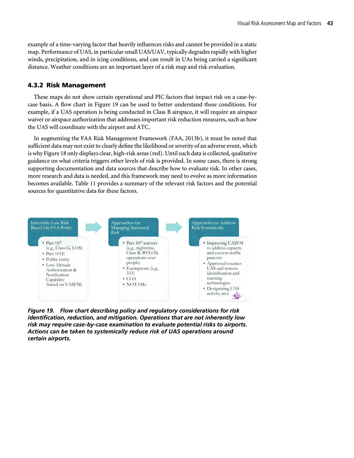
Visual Risk Assessment Map and Factors 43 example of a time-varying factor that heavily influences risks and cannot be provided in a static map. Performance of UAS, in particular small UAS/UAV, typically degrades rapidly with higher winds, precipitation, and in icing conditions, and can result in UAs being carried a significant distance. Weather conditions are an important layer of a risk map and risk evaluation. 4.3.2 Risk Management These maps do not show certain operational and PIC factors that impact risk on a case-by- case basis. A flow chart in Figure 19 can be used to better understand these conditions. For example, if a UAS operation is being conducted in Class B airspace, it will require an airspace waiver or airspace authorization that addresses important risk reduction measures, such as how the UAS will coordinate with the airport and ATC. In augmenting the FAA Risk Management Framework (FAA, 2013b), it must be noted that sufficient data may not exist to clearly define the likelihood or severity of an adverse event, which is why Figure 18 only displays clear, high-risk areas (red). Until such data is collected, qualitative guidance on what criteria triggers other levels of risk is provided. In some cases, there is strong supporting documentation and data sources that describe how to evaluate risk. In other cases, more research and data is needed, and this framework may need to evolve as more information becomes available. Table 11 provides a summary of the relevant risk factors and the potential sources for quantitative data for these factors. Figure 19. Flow chart describing policy and regulatory considerations for risk identification, reduction, and mitigation. Operations that are not inherently low risk may require case-by-case examination to evaluate potential risks to airports. Actions can be taken to systemically reduce risk of UAS operations around certain airports.
Table 11. Risk factors categorized by likelihood and severity of adverse events. Category Risk Factor Risk Evaluation Guidance Risk Guidance Sources Separation Separation mostly relates to likelihood of an adverse event. It can be categorized into: Reserving airspace (e.g., TFR) = Extremely Remote IFR (e.g., ADS-B equipped) UAS flight corridors VFR (e.g., BNSF UAS corridors) Coordination with ATC (relationship between UAS operator and facility) UASFM Aircraft Capability Weight mostly relates to the severity of an adverse event. It can be categorized into: <250 grams = No Safety Impact <55 lbs. = Minor Part 107, FAA Micro UAS Aviation Rulemaking Committee >55 lbs. = Major Airworthiness mostly relates to likelihood of an adverse event. It can be categorized into: Extremely Remote Remote Probable Sensor Fidelity Mostly relates to likelihood of an adverse event. It can be categorized into: Equipment certificate requirement = Extremely Remote Sensor output reliability threshold, lifespan, and accuracy Part 91, General Operating and Flight Rules System Integrity Mitigation measures Part 77 Tracking and Identification Higher-capability systems will result in lower likelihood of adverse events. For example, ADS-B equipped UAS can improve ability to separate, thus reducing risk. Systems and policy are still in development, but specific technologies can be categorized in a way that enables qualitative assessment of likelihood, for example: High capability system (e.g., ADS-B or lighting) is most important when the application is extremely remote Low capability system (e.g., tail number, no electronic broadcast) = Increase probability FAA UAS Remote ID and Tracking Aviation Rulemaking Committee Pilot in Command Operator Capability Level of experience and flight knowledge AC 60-22 Coordination with Airports Complies with CFR for notifying airports during operations Part 107; Part 77 Operator Aptitude Level of experience and aptitude for flight knowledge Part 107 Operational Factor Environment Weather Weather factors such as precipitation, humidity, visibility, and barometric pressure AC 60-22 Terrain Feature Visual features that affect flight operations based on vicinity of airport GIS maps Local Infrastructure Visual features that affect flight operations based on vicinity of airport AC 150/5300- 13A Other Hazards External factors that may affect operations such as wildlife or weather anomalies Local broadcasts and warnings
