
8
Geoheritage Tools
Throughout the workshop, participants suggested tools that extend knowledge about geoheritage, from printed maps to cutting-edge technology. Many expressed the advantages of a set of common tools to stretch resources, maximize impact, avoid the duplication of efforts, and assist in developing common terminology and branding.
SITE DEVELOPMENT AND MONITORING TOOLS
As part of the Geoheritage Tools focus group, Michael Phillips, Illinois Valley Community College, discussed the elements of a checklist that could be adapted to assist in site identification and development processes. These include the proposal process (site identification and prioritization, availability and accessibility, and identification of stakeholders), area/site development, consensus building, maintenance, site use policies, funding and ongoing support and long-term oversight responsibility. “One of the important things I want to mention is consensus building,” he added, linking with some of the earlier presentations. “As sites are identified and developed, one of the key aspects is making sure local people and interested parties are on board. Different groups may have different priorities.” He noted the need to achieve consensus throughout the process. Katherine McCarville, Upper Iowa University, added the group stressed using tools to think “outside the box.”
Amanda Lanik, NPS, described a checklist focused on monitoring sites to evaluate vulnerability and degradation that may warrant mitigation measures. A vulnerability assessment tailored to the specific site is a useful initial action, she suggested, followed by monitoring of visitor use/damage, natural hazards, construction/development, and invasive species. In addition to site visits, photography and 3D methods can be used, which would give a wider range of people virtual interactions and remote access to the sites while preserving the site from anthropic degradation.1 Brilha has described methods and generated a flow chart to help with site inventories, characterization, and development. 2
___________________
1 Also see García-Ortiz, E., I. Fuertes-Gutiérrez, and E. Fernández-Martínez. 2014. Concepts and terminology for the risk of degradation of geological heritage sites: Fragility and natural vulnerability, a case study. Proceedings of the Geologists’ Association 125(4): 463-479. https://doi.org/10.1016/j.pgeola.2014.06.003.
2 In Crofts, R., J.E. Gordon., J. Brilha, M. Gray, J. Gunn, J. Larwood, V.L. Santucci, D. Tormey, and G.L. Worboys. 2020. Guidelines for geoconservation in protected and conserved areas. (p. 25). Best Practice Protected Area Guidelines, Series No. 31. Gland, Switzerland, IUCN, 144 pp. DOI:10.2305/IUCN.CH.2020.PAG.31.en.
TECHNOLOGICAL TOOLS
Throughout the workshop, participants described their use of technology in all aspects of geoheritage. For example, Mattathias (Max) Needle, University of Washington, explained the benefits of 3D capture technology to complement in situ experiences and increase remote access to the site, but said they need to be interactive to have a full experience. Roy Plotnik, University of Illinois at Chicago, suggested that existing areas are “low-hanging fruit” to incorporate geoheritage content, as done for spots in the I&M Canal National Heritage Area.3
Damian Spangrud, Esri’s Director of Solutions, spoke about the digital transformation of geoheritage sites during a webinar. All parts of life are becoming not only digital but also interconnected, he noted, and “the built and natural environments are being brought together “to augment what we understand and represent about a geoheritage site” (see Figure 6). Technology innovation and integration with other information are part of the future and are already under way. “Digital natives” on campuses and in organizations are driving innovation. Moreover, COVID-19 turned “interesting” digital projects into “must-have” projects, such as getting students into the field digitally. Examples include virtual tours of sites or stories about broader landscapes, 3D exploration, and rediscovery of the past. Class materials are becoming virtual and integrating different areas of science and data sources. Other cutting-edge applications integrate sounds with geography (e.g., “soundscapes” created at Montana State University and from Sequoia and Kings Canyon National Parks) and create multilayered digital twins (e.g., a digital twin and research repository created by The Nature Conservancy on the southern California coast). Realizing the transformation requires more than science and technology, he concluded. It requires the art of storytelling, collaboration, innovation, and an inclusive mindset.
Social media “is an efficient, low-cost way to circulate the term ‘geoheritage’ with tangible results, but you need to know your purpose and think carefully before posting,” said Natali Kragh, Montana State University, who also remarked that using the hashtag “#Geoheritage” in social media posts can make geoheritage more explicit and inclusive of work done by others while working in their own disciplines. Reporting from the Geoheritage and Geotourism/Outdoor Recreation focus group, Carol Frost, University of Wyoming, reiterated that while social media is a “great way to promote and build community around geoheritage sites,” it requires daily attention to keep content fresh. In addition, she cautioned, “once posted, content is no longer yours.” A geoheritage-specific concern relates to integrity of a site. “Social media promotion may lead to over-visitation,” she said. While heightened interest has its advantages, managers must also consider security and safety, especially for places that have few or no staff people on site.
OTHER TOOLS
In addition to technology-based tools, a range of other ideas surfaced throughout the workshop to include maps and field guides, interpretative signage and exhibits, and illustrated lectures and field trips. One focus group pointed to the frequent presence of geoheritage in popular culture, and suggested that movies, television shows, novels, and other “general
___________________
3 See https://iandmcanal.org.
audience” outreach serve as a great entry point to highlight geoheritage. This presents an opportunity to describe geoheritage in the context of popular culture.
Participants expressed interest in continuing work through increased scholarly publications on geoheritage to elevate the U.S. presence, organization of theme sessions at diverse professional society meetings, continued participation in international geoheritage events and associations, the potential establishment of a Geoheritage Scientific Division at GSA, and in continuing to grow the U.S. geoheritage community via communication networks (listservs, such as AMERICA-GEOHERITAGE (AMERICA-GEOHERITAGE@LSW.NAS.EDU), created after the workshop) and site visits.
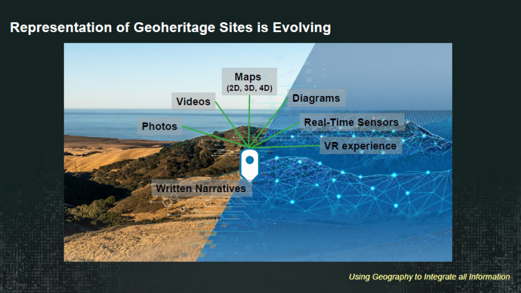
SOURCE: Damian Spangrud, America’s Geoheritage Workshop II, Webinar, December 1, 2020.
This page intentionally left blank.


