
Chapter 4
Applications of Synthesis and Cumulative Effects Assessment in the Gulf of Mexico
INTRODUCTION
The projects funded by the legal settlements of the 2010 Deepwater Horizon (DWH) oil spill (RESTORE Council, 2016) represent an opportunity and a challenge for assessment and learning, because of the unprecedented number and diversity of projects and the 5- to 30-year timeframe of payments from the settlements. Individual project monitoring can inform efforts to ensure that what is learned from early projects benefits successive projects. The large-scale, long-term restoration ongoing in the Gulf of Mexico (GoM) is also an opportunity to assess cumulative effects of multiple projects on a landscape/seascape scale and to lay a foundation for future restoration efforts that will extend beyond the DWH funding timeframe.
Common methodologies and guidance for monitoring individual GoM restoration projects have been established, first by the trustees of the DWH Natural Resource Damage Assessment (NRDA) (DWH NRDA Trustees, 2016; NASEM, 2017), with the most recent monitoring guidance from the RESTORE Council (RESTORE Council, 2021a, b). Shared protocols, when implemented, allow for project comparisons and facilitate adaptive management. A common methodological approach also allows for assessment of cumulative effects at broader spatial scales. However, uncertainty remains about the aggregate benefits or effects of the unprecedentedly large number of restoration projects being concurrently implemented through settlement funds and how to assess them.
The RESTORE Council and NRDA Trustees recognize the need for assessing cumulative effects of multiple restoration projects1 and have signaled that this task will be addressed in future versions of program guidance documents (DWH NRDA Trustees, 2019). The National Fish and Wildlife Foundation (NFWF) has not made a decision on whether a global synthesis of the Gulf Environmental Restoration Fund will be done.2
Some of the major challenges and barriers to assessing cumulative progress in restoration activities have been noted previously (NASEM, 2017). They include:
- inadequate funding and incentives at the project scale for short- and long-term monitoring of appropriate data and lack of human resources support to archive and document collected data,
- the lack of consistent protocols across projects to assure that monitoring and data collected are comparable and useful for cumulative effects assessments,
- the absence of a single freely accessible data repository that receives and archives all types of data from restoration projects in the Gulf, and
___________________
1 See https://www.gulfspillrestoration.noaa.gov/sites/default/files/wp-content/uploads/Final-Phase-III-ERP-PEIS-Record-of-Decision_FINAL.pdf.
2 Personal communication from Jonathan Porthouse, NFWF (September 16, 2021).
- the lack of a single entity or authority tasked with designing and undertaking a cumulative effects assessment to provide information needed for long-term planning at multiple spatial scales and the implementation of adaptive management.
In addition, the lack of standardized methods for assessing cumulative effects (as discussed in Chapter 3) hinders progress in evaluating restoration efficacy at larger scales, as summarized in the DWH NRDA report Deepwater Horizon Oil Spill: Final Programmatic Damage Assessment and Restoration Plan and Final Programmatic Environmental Impact Statement (DWH NRDA Trustees, 2016, p. 5-370):
Even for restoration approaches and/or techniques that are relatively well established (e.g., coastal habitat restoration), uncertainties about the aggregate benefits and/or impacts of restoration projects will be higher as the total number of projects implemented, size of individual projects, and extent to which projects are concentrated in particular geographic areas increases. As restoration scale (i.e., number and size of restoration projects, both independently and within a particular geographic area) increases, it will be more important to ensure that the information about aggregate restoration benefits and potential unintended consequences are incorporated into the monitoring and adaptive management framework.
The challenges identified highlight the need for projects to initiate consistent monitoring for enough time following construction to enable future cumulative effects of multiple projects or large-scale assessments (NASEM, 2017).
This chapter discusses the scales at which cumulative effects of multiple restoration projects have been observed in the GoM, considers cumulative effects assessment methods suitable for different spatial and temporal scales, and identifies elements of a process that could be used to assess the effects of multiple restoration efforts given the potential confounding effects of environmental background trends. The chapter also examines how long-term, larger-scale restoration efforts are suited for analysis by multiple lines of evidence and demonstrates on-the-ground results and techniques that support management decisions.
KEY CONSIDERATIONS AND INFORMATION FOR GULF COAST CUMULATIVE EFFECTS ASSESSMENT
To accurately assess cumulative effects beyond the project scale in the GoM, a deep knowledge of Gulf ecosystems and restoration goals is needed. The challenge of undertaking cumulative effects assessment has been tackled in other locations, where beneficial cumulative effects of multiple restoration projects have been observed at different spatial and temporal scales. Well-documented restoration examples illustrate methods for evaluating large-scale water quality, seagrass, and marsh habitat restoration—the types of projects now being funded in the GoM. They include reductions in nutrient inputs from peak loads in the Baltic Sea, leading to improvements in ecosystem condition (Reusch et al., 2018); nutrient reduction projects that led to submerged aquatic vegetation (SAV) recovery in northern Chesapeake Bay (Gurbisz and Kemp, 2014; Lefchek et al., 2018); dam removals throughout the United States, which catalyze sedimentary changes in coastal landform, habitats, and biota (Foley et al., 2017); and the reconnection of floodplains to deliver food resources that support juvenile salmon in the Columbia River (Diefenderfer et al., 2016). Other evaluations are currently being initiated, such as the cumulative effects of two decades of habitat restoration on Chinook salmon recovery in Puget Sound’s Whidbey Basin (Trujillo et al., 2021). A 2021 special session3 at the National Conference on Ecosystem Restoration, which featured talks from across the United States, indicates the strengthening of a national community around this topic.
As noted throughout this report, detecting the effects of restoration efforts at any spatial scale will likely be hampered by background environmental variation and trends, such as those associated with climate change, as well as anthropogenic impacts, such as overfishing, pollution, and habitat damage. The degree to which background trends prevent detection of restoration benefits will depend on the assessment
___________________
3 “Applying a Beneficial Cumulative Effects Paradigm to Advance Large-Scale Ecosystem Restoration”; see https://conference.ifas.ufl.edu/ncer2021/detailed-agenda.html.
methods used; the magnitude of the trend relative to combined characteristics of the restoration efforts themselves (the number, areal extent, and location of projects); the average effectiveness of those projects in achieving their goals; and the possibility of experiencing antagonistic and synergistic effects from other restoration activities.
The spatial scales at which beneficial cumulative effects from multiple GoM restoration efforts could potentially be observed range from project level (hectares) to estuary/watershed, or even larger scales. Detecting cumulative effects necessitates predictions about the improvements expected at the desired scale, often based on conceptual modeling (see Figure 3.1, in Chapter 3), and sufficient data to accurately determine whether those improvements have been achieved. Key considerations and information needed to perform an assessment of cumulative effects of restoration efforts include an understanding of the following broadly defined factors:
- current conditions and status of the watershed, waterbody, habitats, or animal populations;
- type and severity of background trends (such as climate change effects) and stressors (such as water quality degradation) affecting the ecosystem, and relevant future predictions based on these factors;
- a conceptual or other type of model that predicts how cumulative effects of restoration efforts can be expected to influence ecosystem form, function, or condition;
- restoration efforts, including types, proximity to other restoration projects, potential synergy and antagonistic effects, and spatial and temporal scales of implementation; and
- results of the restoration efforts that can be accessed for analysis.
PRIOR ASSESSMENTS OF THE CUMULATIVE EFFECTS OF ECOSYSTEM RESTORATION AND MANAGEMENT IN THE GULF OF MEXICO
Restoration efforts associated with some of the examples discussed below were initiated before DWH restoration efforts began and provide insight into how assessments of the cumulative effects from multiple projects have occurred to date.
Meta-Analysis and Synthesis of Restoration Projects by Habitat Type
Quantitative analysis and synthesis4 of the effectiveness of different types of restoration, such as the effects of seagrass or oyster reef restoration on a local bay or statewide basis, remain uncommon in the GoM. Several syntheses determined whether restored areas, such as revegetated seagrass plots, remained present at varying numbers of years after the initial revegetation. In a synthesis of seagrass restoration worldwide, van Katwijk et al. (2016) found survival rates of only 22 percent for relatively small-scale seagrass restoration sites and 42 percent of larger sites 2 years after planting. In contrast, in a meta-analysis of Florida seagrass restoration projects, Rezek et al. (2019) found that if a restoration site was still in existence 3 years after installation, almost 90 percent of restored sites contained seagrass; however, the average densities were 37 percent lower than reference areas. In an assessment of seagrass coverage from 2007 to 2017, Handley and Lockwood (2020) compared seagrass gains and losses for each of the Gulf states and found that, for areas where data are being collected, the five Gulf states experienced an overall cumulative gain in seagrass extent of almost 24 percent (127,910 ha) during the 10-year period (see Table 2.1 in Chapter 2). However, the degree to which seagrass meadows are providing ecosystems services at the Gulf scale remains unknown.
Challenges to the validity of these trends in seagrass gains and losses include the lack of a Gulf-wide monitoring strategy, with each state currently using its own methods, as well as the lack of an identified
___________________
4 Synthesis in ecology aims to discover new knowledge by bringing information together and has been defined for estuarine and coastal science as “the inferential process whereby new models are developed from analysis of multiple data sets to explain observed patterns across a range of time and space scales” (Kemp and Boynton, 2012, p. 3).
entity charged to regularly analyze and report trends. Although remote sensing data and models have been used successfully at many U.S. coastal sites to map spatial coverage, density, and biomass of submerged vegetation (Hestir et al., 2016; Meyer and Pu, 2012; Moore et al., 2008; Pu et al., 2014), remotely sensed datasets have not been used to assess the condition of seagrass on a Gulf-wide scale because of the complexities in assessment and modeling that arise from site-specific heterogeneity in water quality and geomorphic settings. Emerging sensing technologies and advanced data analytics and classification methods capable of ingesting heterogenous spatial datasets (discussed in Chapter 5) could make reliable, comprehensive Gulfwide seagrass monitoring feasible in the future (Wang and Furrer, 2021).
Increasingly, assessments of restoration projects include a comparison of whether restored habitats are providing similar functions, and at the same level, as reference areas (i.e., have demonstrated functional equivalency). Simenstad and Thom (1996) explored functional equivalency trajectories, defined as the time it takes for restored wetlands to equate to natural references using appropriate parameters. They evaluated 16 attributes, finding most inconclusive, and they recommended approaches to improving such assessments. They further noted that understanding the source and extent of natural variability of reference sites is key to understanding constructed sites. Kentula (2000) expanded consideration of functional success to landscap-scale restoration, focusing on the contribution to ecological integrity (e.g., Karr et al., 2022; Rohwer and Marris, 2021; Wurtzebach and Schultz, 2016) of a region or landscape in maintaining biodiversity.
Kuhn et al. (1999) showed that some marsh management methods impaired function relative to reference sites in coastal Louisiana. Dillon et al. (2015) compared restored and natural oyster reefs in Grand Bay Mississippi over 2 years and found that constructed reefs performed better in several metrics. A recent meta-analysis of nekton (e.g., shrimp, crabs, fish) abundance in restored versus reference salt marsh areas in the northern Gulf used a functional type of comparison and found that nearly 13 years were needed for the densities of nektonic organisms in restored marshes to approximate those in reference marshes (Hollweg et al., 2020). Suir et al. (2020) found that restored wetlands reached structural and functional equivalency to reference wetlands 3–10 years after construction. They also found that with maturity, restored wetlands outperformed reference wetlands in such metrics as land aggregation, vegetative productivity, and floristic quality.
DWH-funded restoration projects have programmatic guidance available for identifying restoration objectives, monitoring certain performance-based metrics throughout the project, and assessing whether restoration objectives have been achieved by the end of the project. Table 4.1 illustrates the main DWH funding entities and their data reporting requirements. Specific guidance regarding project monitoring and performance assessment can be found in Monitoring and Adaptive Management Procedures and Guidelines Manual Version 1.0 (MAM Manual) for NRDA (DWH NRDA Trustees, 2019) and the Observational Data Plan Guidelines for the RESTORE Council (RESTORE Council, 2021b).
Synthesis of changes in project-level metrics for multiple restoration efforts within a defined geographic area theoretically could provide evidence of cumulative effects (as discussed in Chapter 3), though this effort could be complicated because similar project types could conduct postimplementation monitoring for varying lengths of time, depending on the project sponsor. Synthesis of analytical results within lines of evidence has been identified as an important step in assessing the cumulative effects of large-scale restoration for at least a decade (Diefenderfer et al., 2011, 2016). To examine the feasibility of synthesizing DWH-funded project-level monitoring data and information regarding attainment of restoration objectives, the committee attempted to obtain relevant data online or through direct contacts for a cumulative effects assessment. It was not successful in obtaining adequate information to do an analysis, due to the inability to access data without extensive outreach to individual project contacts.
Despite repeated calls for consistent and transparent monitoring and assessment (summarized in NASEM, 2017), barriers continue to exist for accurate collation of monitoring and assessment of successes or failures in meeting restoration objectives. Funding streams have varied monitoring specifications and for inconsistent durations, and not all funding sources post final reports or have readily accessible monitoring data. Many of the records in both the Council Monitoring and Assessment Program (CMAP) and
TABLE 4.1. Main DWH Funding Entities Responsible for Providing Data Reporting Guidance at the Project and Programmatic Scales
| DWH Funding Entities | Project-Level Monitoring Guidance | Project Monitoring Data Location | Program-Level Monitoring Guidance |
|---|---|---|---|
| National Fish and Wildlife Foundation (NFWF) Gulf Environmental Benefit Fund | Not publicly available. a | Project monitoring data is not publicly available based on searches. NFWF encourages, but does not require, recipients to make their data public in some way. a | Not publicly available.b |
| DWH National Resource Damage and Assessment (NRDA) Trustees | The Monitoring and Adaptive Management Manual provides “the TIGs [trustee implementation groups] with detailed information on recommended MAM [monitoring and adaptive management] procedures and guidelines, as well as additional guidance for the development of MAM Plans and the implementation of MAM at the project, [r]estoration [t]ype, and programmatic levels” (p. 2).c | The DIVER Repository contains MAM parameters. Additional project data may also be available in some cases.d | DWH NRDA Trustees indicate in the Monitoring and Adaptive Management Manual that “further [r]estoration [t]ype and program-level guidance will be developed in future versions of the MAM Manual” (p. 2).c |
| RESTORE Council | Observational Data Plan (ODP) Guidance: “Data should be submitted to a publicly available repository within two years of data collection, unless otherwise specified in the ODP Plan. Annual reporting on data collection is required during the Council’s annual performance reporting period” (p. 26).e The Council also requires annual reporting and project closeout reporting. | Council MERLIN site contains metadata for Bucket 2 projects, as well as links and downloads to project-specific monitoring data that may be housed in other locations.f | None at this time. The Council’s Comprehensive Plan Update notes, “The Council will utilize its staff, CMAWG [Council Monitoring and Assessment Work Group], CoP [Gulf of Mexico Alliance Monitoring Community of Practice], and coordination with other entities as a means to develop common standards and monitoring protocols for Council projects and programs; indicators and metrics of restoration and conservation success (including ecological function, benefits, and services) by project, region and/or watershed; identify data gaps in the assessment of the success of Gulf-wide restoration; and evaluate tools to measure Gulf-wide benefits” (p. 28).b |
a Personal communication from Jonathan Porthouse, NFWF (March 25, 2022).
b See https://www.restorethegulf.gov/sites/default/files/CO-PL_20161208_CompPlanUpdate_English.pdf.
c See https://www.gulfspillrestoration.noaa.gov/sites/default/files/2019-08%20MAM_Manual_FULL_Updated%202019.pdf (p. 2).
d DIVER, Data Integration Visualization Exploration and Reporting; see https://www.diver.orr.noaa.gov/web/guest/diverex-plorer?sqid=642&subtitle=DWH+Restoration+Project+Data.
e See https://restorethegulf.gov/sites/default/files/20210520_Council_Observational_Data_Plan_Guidelines_Version%202.0_508.pdf.
f See https://restorethegulf.gov/merlin/srv/eng/catalog.search#/home.
the Gulf of Mexico Alliance (GOMA) project tracker5 databases lack links to posted results or points of contact. The NRDA Trustees recognize these barriers6 and have made recent progress toward reporting on restoration projects implemented to date, including publication of their 2021 programmatic review (DWH NRDA Trustees, 2021). Future MAM manuals are anticipated to include larger-than-project-scale guidance (DWH NRDA Trustees, 2019), and the LA TIG issued MAM guidance for Louisiana in 2021 (DWH NRDA LA TIG, 2021).
When more data are made available, it may be possible to “roll-up” project-level information into an assessment of potential cumulative effects (as defined in Box 3.1, in Chapter 3) within a geographic area or for specific outcomes of interest, ecosystem types, or restoration methods. The lines of evidence used by a program manager to assess cumulative effects will depend on the type and number of projects being implemented, the scale and relative impact of the projects, the proximity of projects to each other, the geographic extent of the program area being assessed, and the type and extent of data available to support the assessment. Examples of syntheses in the GoM that have attempted to detect beneficial cumulative effects of multiple restoration efforts at the estuary/watershed- and Gulf-wide scales, though limited, are provided in this section as references for future assessments.
Estuary- and Watershed-Scale Program Assessment Examples
Existing examples of cumulative effects of restoration at the estuary and watershed scales share the characteristic of an intermediate geographic scale, between an individual restoration project and the Gulf Coast, and are hydrogeomorphic units with high internal connectivity. This connectivity of hydrological and sedimentary processes that are foundations of and controlling factors on ecological processes and species’ habitats (cf. Groffman et al., 2004) makes them a natural unit of management and assessment (Li et al., 2020a).
At the estuary/watershed scales, several long-term, science-based resource management programs located in the GoM offer examples of the application of multiple lines of evidence (see Chapter 3) to assess cumulative effects of the many restoration actions implemented in each estuary over the last 3 decades. Although not designed to assess cumulative effects, the Tampa Bay Estuary Program (TBEP) in Florida and its partners, the Galveston Bay National Estuary Program in Texas in partnership with the Galveston Bay Foundation, and the Comprehensive Everglades Restoration Plan each used tools and techniques similar to the theoretical approaches outlined in Chapter 3. Each program developed and now applies site-specific approaches to assessing cumulative effects of restoration efforts within their study areas, as outlined below.
In addition, each of these examples (initiated decades ago) did not originally incorporate explicit considerations of long-term environmental trends in their conceptual models and restoration designs. However, as these trends (especially those associated with climate change) have become obvious, each program has used an adaptive management approach to revise restoration plans, goals, and project designs. For example, TBEP has recently updated their habitat masterplan with a new conceptual approach, which accounts for future stressors (including sea level rise, climate change, and watershed development) in the target setting process (Robison et al., 2020).
Tampa Bay Estuary Program
Located on the west coast of Florida, Tampa Bay is a shallow, 1,035 km2 estuary with a population of 3 million in the 6,735 km2 watershed.7 In the 1970s, Tampa Bay was significantly impacted by nutrient overenrichment and eutrophic conditions, including degraded water quality, persistent algal and macroalgal blooms, depleted oxygen levels and fish kills, and an estimated 50 percent loss of seagrass between 1950 and the mid-1970s (Greening et al., 2014).
___________________
5 See https://dwhprojecttracker.org/.
6 See https://www.gulfspillrestoration.noaa.gov/sites/default/files/wp-content/uploads/Final-Phase-III-ERP-PEIS-Record-of-Decision_FINAL.pdf.
In response to local citizens’ calls for action, state regulatory restrictions on wastewater treatments plants located in the Tampa Bay watershed were put in place in 1978. This marked the beginning of Tampa Bay’s restoration and recovery. Nearly 900 projects for improving water quality have since been completed by the public/private Tampa Bay Nitrogen Management Consortium (TBNMC), representing regulatory compliance-driven activities (e.g., water treatment upgrades, stormwater retrofits, power plant scrubber updates, industrial discharge reductions, residential fertilizer use ordinances) (Raulerson et al., 2019) and voluntary actions (e.g., habitat acquisition and restoration, education and social marketing campaigns) (Beck et al., 2019). The cumulative effects of nutrient reductions from these actions—implemented by local governments, industries, utilities, and homeowners—have reduced total nitrogen loads to half of those estimated in the mid-1970s, and water clarity conditions were improved roughly to those observed in 1950, when human population in the watershed was less than 20 percent of what it is today. In 2018, 164.4 km2 of seagrasses were reported throughout the bay, exceeding the 1950 areal extent target established by TBEP partners in 1995 by about 10.6 km2 (Beck et al., 2020). Between 2018 and 2020, however, mapped seagrass extent was reduced by almost 16 percent, possibly associated with recent seasonal algal blooms8 (Beck et al., 2022).
Key elements of TBEP’s assessment of cumulative effects associated with these multiple restoration efforts include:
- annual synthesis, analysis, and reporting of ambient water quality monitoring data collected by the three counties surrounding the bay;
- seagrass extent estimates every 2 years by the Southwest Florida Water Management District; and
- comparison to numerical targets for both water quality metrics and seagrass extent (Beck et al., 2022).
A publicly accessible database of restoration projects9 is maintained by TBEP, updated by the TBNMC partners, and used to synthesize the types, locations, and estimated nutrient reductions from projects implemented in the bay and the watershed every 5 years as part of demonstration of attainment of water quality regulatory thresholds. If thresholds are not met, the TBNMC has developed a decision matrix to identify and address potential factors impacting water quality and/or seagrass extent (TBNMC, 2017).
A timeline of the Tampa Bay nutrient management strategy demonstrates the use of lines of evidence, including those described in Chapter 3 and those developed by TBEP and its partners (see Table 4.2). In addition, a recent paper (Beck et al., 2019) applied a cumulative effects approach to an empirical modeling-based reassessment of data on the interactions between water quality improvement projects and seagrass recovery projects in Tampa Bay.
Galveston Bay National Estuary Program
Galveston Bay is the seventh-largest estuary in the United States, encompassing ~1,600 km2, with a 62,200 km2 watershed and a population of 5.4 million.10 It is a subtropical estuary with an average depth of 2.1m, fed primarily by the San Jacinto and Trinity Rivers. Houston, the fifth-largest U.S. city, sits at the northwest end of the bay. The port of Houston ranks second nationally by tonnage and first in foreign traffic, primarily petroleum based. The Houston area produces about 44 percent of U.S. petrochemicals (42.6 million tons per year) and 14 percent of U.S refining capacity.
Galveston Bay has faced many challenges due to coastal development. Approximately 182 km2 of wetlands were lost over 60 years (Texas Environment, 2011), and seagrass beds have mostly disappeared over that same period. Seafood consumption advisories were issued for the bay starting in 1990, and approximately half of the bay’s wetlands have been lost due to relative sea level rise, diminished sediment supply, and human activities (GBEP, 2018). Freshwater diversions for municipal, industrial, and agricultural uses, particularly in the Trinity River watershed, have negatively impacted the Bay (GBNEP, 1995). Loss of freshwater has altered salinities, diminished sediments, and negatively affected water quality.
___________________
8 See https://tampabay.wateratlas.usf.edu/seagrass-monitoring/.
TABLE 4.2. Assessment of Cumulative Effects of Environmental Restoration Efforts in Tampa Bay and Galveston Bay (by decade). Lines of evidence include those defined in Chapter 3 (Table 3.1)
| Tampa Bay | Galveston Bay | |||||
|---|---|---|---|---|---|---|
| Decade | Conditions and Changes: Adaptive Management | Site-Specific Assessment Techniques | Lines of Evidence | Conditions and Changes: Adaptive Management | Site-Specific Assessment Techniques | Lines of Evidence |
| 1970s | Ecosystem degradation: clear water seagrass-dominated system to macroalgae- and phytoplankton-dominated system | Water quality monitoring data collection initiated (monthly at 60 stations in the bay) | Research on critical ecological uncertainties | Water quality monitoring data collection initiated | Research on critical ecological uncertainties | |
| 1980s | Wastewater treatment plant upgrades stipulated to reduce by 90%; implemented by 1982 (state regulation) | Seagrass areal extent monitoring initiated (every 2 years) | Analysis of data and modeling of target species | Galveston Bay designated an estuary of national significance, 1987 | ||
| 1990s |
Tampa Bay National Estuary Program formed; conceptual model and simple hypothesis developed Tampa Bay Nitrogen Management Consortium agrees to collaborate to meet nutrient load target, multiple nutrient reduction and restoration projects implemented Consortium develops total nitrogen (TN) loading caps for all sources |
Numeric targets approved and adopted for seagrass acreage, light attenuation, chlorophyll a concentration, nutrient loading caps Tampa Bay Nutrient Management Strategy |
Review of literature: Analysis of data on target species: light conditions of seagrass at deep edges Mechanistic and empirical models |
1995 Comprehensive Management Plan adopted Texas Estuaries Act (1999) funds restoration actions and coordinates state agency actions Total maximum daily load (TMDL) and implementation plans established for lower Galveston Bay watershed; Watershed Protection Plans established for lower Galveston Bay |
Review of literature: Hypothesis: A collaborative public–private effort to restore habitat, conserve fish and wildlife populations, improve water quality and sediment contamination, and harmonize multi-use conflicts will improve and sustain bay health |
|
| 2000s-ongoing | Assessment of cumulative effects on nutrient loading, ambient water quality and clarity, seagrass; reevaluation of models every 5 years; tracking restoration efforts Active adaptive management |
Water quality and seagrass monitoring with annual reporting, assessment, and adjustment; land use and land cover change analysis every 5 years Tampa Bay Nutrient Management Strategy Assessment |
Change analysis on landscape setting Meta-analysis of restoration action effectiveness Synthesis of cumulative effects from multiple restoration efforts Modeling of cumulative net ecosystem improvement |
Multiple restoration efforts on water quality, wetlands, and oysters were implemented | ||
| 2010s-ongoing | Tampa Bay Nutrient Management Strategy Assessment | Galveston Bay Program sets goals for improving water quality, habitat conservation, species conservation, sustaining freshwater inflows, collaborative monitoring Active adaptive management 1995 Comprehensive Management Plan updated based on annual Galveston Bay Report Card findings Charting the Course to 2015: Galveston Bay Strategic Action Plan (2009) and The Galveston Bay Plan, 2nd Edition (2018) |
Galveston Bay Report Card analyzes data and trends from 19 metrics for water quality, pollution events and sources, wildlife, habitat, human health risks, and coastal change; report cards continue annually | Analysis of data on target species Synthesis of cumulative effects from multiple restoration efforts Physical modeling of ecosystem controlling factors: hydrodynamics/ freshwater inflows | ||
| 2020s-ongoing | Evaluation of alternative hypotheses for seagrass recovery backsliding in some areas | Tampa Bay Nutrient Management Strategy Assessment | Physical modeling of ecosystem controlling factors: hydrodynamics Research on critical ecological uncertainties: algal blooms |
Watershed and bay assessment of nitrogen phosphorus concentrations, dissolved oxygen Synthesis of sediment pollution loads and sources related to seafood consumption. Fifteen years data for organics and metals Assessment of oil spill impacts since 1998 Freshwater inflow assessment of change from 2003 to 2016 data Assessment of relative sea level change, pH and water temperature related to climate change between 2005 and 2018 |
Galveston Bay Report Card | Synthesis of cumulative effects from multiple restoration efforts Research on critical ecological uncertainties: Synthesis of finfish, shellfish, and water birds data and trends—2005–2010 Synthesis of habitat (emergent and submergent) status and trends 1953 to 2019; oysters, 1995 to 2019 Analysis of data on target species Meta-analysis coastal change from 2010 to 2019 Change analysis on landscape setting |
The formation of the Galveston Bay Council11 in 1995 brought together a 42-member group of federal and state agencies, local government, nongovernmental organizations, businesses and industry, and private citizens to guide plan implementation and future strategies. Several tools were developed to monitor environmental trends and the progress of the plan’s implementation, including the Galveston Bay Report Card.12 Since 2015, the Galveston Bay Report Card has generated an annual analysis of the bay’s environmental health. Led by the Galveston Bay Foundation and Houston Advanced Research Center, the report card assesses six different metrics of bay health: water quality, pollution events and sources, wildlife, habitat, human health risks, and coastal change. Data sources include hydrologic monitoring and various state and federal agency data sources compiled into a regional monitoring portal.13Table 4.2 outlines the process used in Galveston Bay including lines of evidence described in Chapter 3 and those developed by the Galveston Bay partners.
The Galveston Bay Report Card has proven an effective tool for guiding restoration efforts, as a communication tool, and as an implicit assessment of the cumulative effects of restoration within the Bay and its watershed. Since 2000, 117 km2 of coastal and watershed habitat have been protected, restored, or enhanced (GBEP, 2018). Water quality monitoring data collected between 1970 and 2017 (HARC, 2020) indicate that, despite a declining trend in bay waters, dissolved oxygen levels appear healthy and remain above 6 mg/L. Total phosphorus and ammonia concentrations have declined as well. However, after the sharp decline in chlorophyll a concentrations in the 1980s and 1990s, peaks were seen in 2003, 2007, and 2009. Since then, concentrations have remained elevated. Changes in freshwater inflows have the greatest effect on parameters like chlorophyll a (Pinckney et al., 2017), but the complex interaction of multiple stressors within the bay system preclude a current understanding of why the chlorophyll a levels are elevated.
Key characteristics of the methods and processes used by estuary-scale efforts have been associated with the attainment of goals and ecosystem improvements (Greening et al., 2014; Gross and Hagy, 2017; Sherwood et al., 2016; Tomasko et al., 2018), thus providing an indication of the cumulative effects of multiple restoration efforts. These characteristics include:
- targeted resources and metrics are recognized as important by both the public and scientists;
- the community is willing to work together toward common goals;
- science-based measurable goals and targets have been adopted;
- multiple tools are considered, such as regulation, public–private collaborative actions, and citizen actions;
- long-term monitoring, synthesis, and reporting mechanisms are in place;
- a convener to track, facilitate, and report progress is recognized;
- program assessment and adjustment (an adaptive management approach) is used;
- a link to the economic value of a healthy ecosystem has been established; and
- large (size) or a large number of projects addressing common stressors have been implemented.
Comprehensive Everglades Restoration Plan
The Comprehensive Everglades Restoration Plan (CERP) is a watershed approach for restoring, protecting, and preserving the greater Florida Everglades ecosystem. The plan aims to restore the hydrology, improve water quality, restore natural habitats, and protect native species.14 Monitoring the numbers of nesting birds over three decades indicated that the cumulative effects of extensive water management efforts and restoration projects within the Everglades system have contributed to restoring contiguous aquatic habitat and prey populations, as well as supporting increased nesting success of several wading bird populations (Beerens et al., 2015; Pearlstine et al., 2020). Another metric of cumulative effects of multiple restoration efforts in the greater Everglades ecosystem is water quality. Over the last 20 years, $1.8 billion
___________________
11 See https://gbep.texas.gov/the-galveston-bay-council/.
12 See https://www.galvbaygrade.org/.
13 See https://www.waterdatafortexas.org/coastal and https://gbep.texas.gov/regional-monitoring-portal/.
14 See https://www.sfwmd.gov/our-work/cerp-project-planning.
has been invested in phosphorus control programs that have significantly improved Everglades water quality, with average phosphorus concentrations reduced from 24 to 9 ppb; at least 90 percent of the Everglades now meets water quality standards of 10 ppb or less for phosphorus concentration.15 Similar improvements were noted by NASEM (2018b), which found that completed CERP components were beginning to show benefits, including creating hydrologic conditions increasingly similar to predrainage flows in some areas. However, as noted in Progress Toward Restoring the Everglades: The Eighth Biennial Review (NASEM, 2021), the ability to detect restoration progress is limited by monitoring, analysis, and results communication.
Despite multiple water management projects and observed improvements within the Everglades system, widespread downstream effects in the receiving waters of Florida Bay have not yet been realized. A major CERP objective is to manage the volume, distribution, and timing of freshwater inflow to Florida Bay, thereby returning the bay to historical ecological conditions (Cole et al., 2018). Changes in water usage in the Everglades have caused a 60 percent decline in freshwater inflow into Florida Bay, with resultant increases in hypersalinity (Herbert et al., 2011). Cole et al. (2018) examined year-to-year and basin-scale interactions between water quality and seagrass across 15 transects in Florida Bay between 2006 and 2013. They noted that, although restoration actions related to increasing freshwater inflow have been initiated by CERP, this intervention has, at this point, not led to significant decreases in salinity in parts of Florida Bay. They concluded that without further efforts to release freshwater during droughts, seagrass die-off events may recur.
Over the past few decades, the three estuary/watershed-scale examples highlighted above implicitly incorporated key elements of ecosystem restoration (Gann et al., 2019), including a basis in conceptual ecosystem models from which hypotheses and questions about ecosystem functions and the steps necessary to achieve them were derived. These questions were addressed and refined through long-term (multidecadal) monitoring and research, and adaptive management approaches to considering effects of long-term trends continue to be used to refine restoration plans.
Gulf-Wide and National-Scale Programs
National programs have contributed to significant improvements in U.S. waterbodies, including those in the GoM. For example, significant improvements in many U.S. waterbodies are the result of projects implemented to meet Clean Water Act provisions, which are aimed at reducing pollution from industry, sewage treatment plants, and other point sources. Between 1962 and 2001, many metrics of water pollution, such as biochemical oxygen demand, fecal coliform counts, total suspended solids, and water bodies considered “not swimmable,” collected at 240,000 monitoring sites nationwide showed improvement (Keiser et al., 2018). Federal Clean Water Act (CWA) grants to install nutrient reduction technology from wastewater treatment plant discharges made rivers significantly cleaner for up to 25 miles downstream (Keiser et al., 2018).
Similarly, from 1970 to 2017, implementation of the national Clean Air Act resulted in a reduction of 73 percent of the six common air quality pollutants nationally.16 In the GoM watershed, trends in atmospheric wet nitrogen deposition (from National Atmospheric Deposition Program data) from four sites in the Mississippi River watershed show decreasing or relatively steady nitrogen deposition since the early 1980s. As noted by Whitall (2008), these modest improvements may be related to the Clean Air Act Amendments of 1990. The Clean Air Act may have resulted in a reduction in the amount of nutrients deposited via atmospheric deposition to the GoM watershed and directly to the Gulf’s surface waters (Whitall, 2008).
The scale of effort to improve clean air and clean water through the programs of the Clean Air Act17 and Clean Water Act was significant and sustained (Keiser et al., 2018). In each case, adequate monitoring and data collection to measure progress and assess the performance of the programs occurred over a long period of time. It is notable, however, that while some datasets are tightly quality controlled, data on water
___________________
15 See https://www.sfwmd.gov/our-work/cerp-project-planning and https://www.sfwmd.gov/our-work/wq-stas.
16 See https://www.epa.gov/clean-air-act-overview.
17 See https://www.epa.gov/sites/default/files/2015-07/documents/summaryreport.pdf.
quality have been collected under the auspices of federal agencies, states, nongovernmental organizations, and academic researchers, and these collection methods and measurements are not all consistent. In addition, data accessibility remains inadequate, so it has been difficult for analysts to use these data in a rigorous and consistent manner (Keiser et al., 2018).
Despite significant reductions in pollutant sources from national water quality programs and demonstrated improvements in upstream reaches, Gulf-wide water quality assessments from the National Coastal Condition Assessment of the U.S. Environmental Protection Agency (EPA) showed increases in the percent of areas rated “poor” for the eutrophication index from three periods between 2005 and 2015 (EPA, 2021). Several factors have likely contributed to the lack of observed water quality improvements at the Gulf-wide scale. Most experts agree that non–point-source pollution, which the Clean Water Act does not directly address, is the most pressing and challenging water quality problem in the northern Gulf of Mexico (NRC, 2012). Robertson and Saad (2013) estimated that 60 percent of nitrogen and 49 percent of phosphorus entering the GoM are from agricultural sources (e.g., cropland, fertilizers, manure, nitrogen fixation). Although management of agricultural practices has resulted in nutrient reduction from individual fields throughout the Mississippi River basin, (reviewed in Daniels et al., 2018), collectively these reductions contribute only a very small percentage to the overall nutrient budget of the Mississippi River basin.
In addition, lag times between field-scale management and response of water quality metrics in streams often mask any immediate gains in reduction and may take years of in-stream monitoring to detect (Sharpley et al., 2009). Variability in rainfall and rainfall patterns result in large differences in nutrient delivery and transport at both annual and larger time scales, increasing the difficulty in detecting changes in the receiving waters (streams, river, or Gulf) associated with nutrient management practices on land and other long-term environmental trends.
The five Gulf states had large-scale water-quality improvement proposals awarded in 2020–2021 through the RESTORE Council.18 These included Louisiana’s River Reintroduction into the Maurepas Swamp, Alabama’s Perdido River Land Conservation and Habitat Enhancements, the Coastal Alabama Regional Water Quality Program and Perdido Watershed Water Quality Improvements and Restoration Assessment Program, the Florida Water Quality Improvement Program and Florida Gulf Coast Tributaries Hydrologic Restoration Program, the Water Quality Improvement Program for Coastal Mississippi Waters, and the Texas Coastal Water Quality Program. With water quality projects being implemented at the multistate scale, cumulative beneficial effects may occur, some of which may cross state lines through aquatic connectivity (such as Mississippi/Alabama and Alabama/Florida). This may also be an opportunity for states to collaborate on sampling methods and designs to capture larger-scale responses to collective restoration efforts and assess effects of background trends.
Living Resources: Oysters, Fisheries, Turtles, and Marine Mammals
Gulf-wide assessments of coastal living resources and target species, including oysters, nearshore fisheries stocks, turtles, and marine mammals, can produce quality data that may be able to detect cumulative effects Gulf-wide in the future.
Currently, and as identified in Chapter 2, there are no accurate Gulf-wide assessments of oyster abundance. However, although landings data cannot provide accurate estimates of population size, they provide some indication of a resource’s distribution (GSMFC, 2012). Annual combined commercial oyster landing statistics for the five Gulf states show yearly fluctuations over the period 1950–2019, with a possible decline from a peak in the mid-1980s.19
Significant funds and effort have been dedicated to restoring oyster abundance and habitat in the GoM. An inventory of oyster restoration projects by the DWH funding entities identified a total of 67 approved
___________________
18 See https://www.restorethegulf.gov/funded-priorities-list-3b.
19 See https://www.fisheries.noaa.gov/national/sustainable-fisheries/commercial-fisheries-landings.
oyster-related projects (for a total of ~$175M) distributed throughout the states over the last decade.20 Project types include research, aquaculture, decision support, shell recycling, and planning, and 30 projects are focused on restoration or enhancement of oyster reefs. As of January 2021, completed restoration and enhancement projects have resulted in a total of 2,522 acres of oyster reefs, with a goal of an additional ~2,000 acres from active and awarded projects (Brooke, 2021).
Stock assessments for a limited number of inshore and nearshore fish species, such as Gulf menhaden, are prepared by the Southeast Data, Assessment, and Review process (SEDAR).21 SEDAR is a cooperative program between state and federal resource managers to improve the quality and reliability of fishery stock assessments. Their procedures and experiences can inform efforts in monitoring and assessment efforts related to restoration assessments across disciplines and political boundaries. SEDAR cooperators include the South Atlantic Fishery Management Council and the Fisheries Southeast Fisheries Science Center and Southeast Regional Office of the National Oceanic and Atmospheric Administration (NOAA), the Gulf of Mexico and Caribbean Fishery Management Councils, the Atlantic States and Gulf States Marine Fisheries Commissions, and NOAA’s Fisheries Highly Migratory Species Division. Advantages of SEDAR stock assessments include the use of consistent methodology, the likelihood that SEDAR will continue to be supported by the cooperators over time, and the accessibility of data and analyses.
There have been recent efforts to develop more holistic ecosystem-based approaches to fisheries management—for example, transitioning from single to multispecies assessments in the GoM. Dell’Apa et al. (2020) suggest that tools conducive to the effective integration of ecosystem considerations into fisheries management are needed. These tools could inform and guide the work of regional managers, decision makers, and stakeholders in the GoM by allowing them to include the effects of other fisheries sectors, as well as environmental and ecological background trends. Development and applications of ecosystem-based methods could assist in separating background variation from the cumulative effects of restoration on fisheries in the GoM. Comprehensive data on additional fish stocks in the GoM other than those tracked by SEDAR and bird rookeries were not collected in regular intervals before DWH, and thus it would be difficult to assess longitudinal impacts as a result of DWH.
Sea turtles and marine mammals move among many locations in the GoM and are affected by a variety of environmental stressors (Carmichael et al., 2012; Frasier et al., 2020; Kellar et al., 2017; Kucklick et al., 2011), making it difficult to assess stressors that can lead to declines in individual and population health. Focused restoration efforts for marine mammals were developed by the DWH NRDA Trustees (2017c) and considered the long time frames needed for these populations to be restored. For example, it is estimated that, without targeted restoration, Barataria Bay dolphins need 39 years and and offshore cetaceans need from 10 to as many as 105 years for their communities to be restored from DWH effects.22
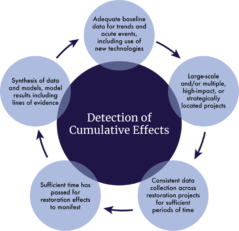
As demonstrated by the examples included in this chapter, the successful detection of cumulative effects of GoM restoration projects have to include consideration of a number of factors throughout the program’s duration (see Figure 4.1). Key factors include the availability of adequate baseline monitoring to assess the effects of background trends, the scale of restoration projects, the collection of consistent project-level data for sufficient time to allow cumulative effects assessment, and the use of multiple lines of evidence and models to synthesize results.
MEETING THE CHALLENGES OF GULF COAST–SCALE ASSESSMENT
Programmatic Goals of the DWH Funding Entities
There is a wide array of restoration programs within the GoM, but all are working toward beneficial effects on the Gulf Coast. DWH settlement–funded programs have developed complementary goals related
___________________
20 See https://www.gsmfc.org/ann_mtgs/2022-03/MSSC/4.%20Gulf%20oyster%20restoration%20projects%20Brooke%20FSU.pdf.
21 See http://sedarweb.org/.
22 See https://www.fisheries.noaa.gov/national/marine-life-distress/sea-turtles-dolphins-and-whales-10-years-after-deepwater-horizon-oil.
to ecosystem restoration, generally focusing on four areas: habitat, water quality, living coastal and marine resources, and resilience (see Table 4.3). The DWH NRDA Trustees goals are to understand the GoM ecosystem and the injuries sustained from the DWH oil spill, developed through a scoping process that included public involvement (DWH NRDA Trustees, 2016). The RESTORE Council updated its overall goals in 2016 (RESTORE Council, 2016). The NFWF goals are consistent with the terms of the plea agreements and support projects that remedy harm to habitats and species where there has been injury resulting from DWH.23 The U.S. Fish and Wildlife Service North American Wetlands Conservation Fund, with their focus on wetland conservation and bird habitat, also has similar aims. These four focus areas provide the foundation for a general hypothesis framework for the synthesis of programmatic outcomes (see Table 4.3).
Assessing Potential Nonlinear (Synergistic and Antagonistic) Cumulative Effects of DWH Program Approaches
Chapter 3 introduced the potential for nonlinear effects, either synergistic or antagonistic, to occur in multiple restoration activities being conducted to improve the condition of ecosystems, water bodies, and species. Table 3.1 in that chapter presents examples of practical methods for predicting, measuring, and evaluating certain nonlinear effects in several Gulf Coast subregions. This section further specifies the ecosystem pressures and stressors, potential synergies and antagonisms, and measurement and modeling methods associated with these restoration types.
___________________
23 See https://www.nfwf.org/gulf-environmental-benefit-fund/priorities.
TABLE 4.3. Restoration Focus Areas and Hypotheses to Support Synthesis of Programmatic Outcomes and Corresponding Goals and Objectives of the DWH Settlement–Funded Programs
| Restoration Focus Areas | ||||
|---|---|---|---|---|
| Habitat | Water Quality | Living Coastal and Marine Resources | Resilience | |
| Hypothesis: Through restoration, coastal habitats will maintain or increase areal coverage, function, and ecosystem diversity | Hypothesis: Through restoration, water quality will be restored or protected in coastal and marine areas | Hypothesis: Through restoration, species populations will be maintained or replenished | Hypothesis: Through restoration, coastal ecosystems and communities will be resilient to changing conditions | |
| Entities Controlling DWH Ecosystem Restoration Funds | Habitat | Water Quality | Living Coastal and Marine Resources | Resilience |
|
National Fish and Wildlife Foundation ($2.544B) Source: https://www.nfwf.org/gulf-environmentalbenefit-fund/priorities |
Restore and maintain the ecological functions of landscape-scale coastal habitats, including barrier islands, beaches, and coastal marshes, and ensure their viability and resilience against existing and future threats, such as sea level rise. | Replenish and protect living resources, including oysters, red snapper and other reef fish, Gulf Coast bird populations, sea turtles, and marine mammals. | ||
|
DWH Natural Resource Damage Assessment ($8.1B) Source: DWH NRDA Trustees 2016. pp. 5-15 to 5-17, Figure 5.4-11 |
Restore and conserve habitat (includes wetlands, coastal and nearshore habitats) | Restore water quality (includes nutrient reduction and water quality) | Replenish and protect living coastal and marine resources (includes fish and water column invertebrates, sturgeon, sea turtles, submerged aquatic vegetation, marine mammals, birds, mesophotic and deep benthic communities, oysters) | |
|
RESTORE Council ($1.56B) Source: RESTORE Council (2016) |
Restore and conserve the health, diversity, and resilience of key coastal, estuarine, and marine habitats | Restore and protect the water quality and quantity of the Gulf Coast region’s fresh-, estuarine, and marine waters | Restore and protect healthy, diverse, and sustainable living coastal and marine resources | Build on and sustain communities with capacity to adapt to short- and long-term changes |
Understanding the linkages between ecosystems is essential for predicting and designing appropriate measurement methods for nonlinear effects. The potential for synergistic effects on secondary production to be achieved through the restoration of primary production (as shown in Figure 3.2, in Chapter 3) has been understood for decades (Peterson and Lipcius, 2003), yet verification of this relationship still necessitates a time-consuming suite of field and laboratory procedures (Sather et al., 2016; Sobocinski and Latour, 2015). Understanding the drivers, pressures, and stressors on ecosystems (see definitions in Box 2.1, in Chapter 2) is a primary step that facilitates the ability to predict nonlinear effects and design methods to detect them.
Examples of pressures and stressors on six primary GoM restoration types are shown in Table 4.4. The interactions between pressures and stressors are evident throughout the table. Connectivity among aquatic habitats, for example, stands out as a primary mechanism for interactions with nonlinear effects having to do with water quantity and quality, plant detritus, and biota. For another example, oyster reefs help mitigate the negative effects of nitrogen (Arfken et al., 2017) that over-fertilizes coastal waters (see case study in Chapter 3; Boynton and Kemp, 2008), thus having the potential for synergistic effects with DWH-funded projects aimed at water quality (shown in Table 4.4). Furthermore, intensifying trends in both chronic and acute stressors affecting SAV, emergent marshes, and mangroves (see Chapter 2) enhance the urgency for determining which restoration actions—or suites of actions—will have positive or negative effects.
TABLE 4.4. Potential Synergistic and Antagonistic Effects of Restoration Approaches
| Restoration Approaches and Anticipated Outcomes | Ecosystem | Synergistic and Antagonistic Considerations | |||
|---|---|---|---|---|---|
| Restoration Type | Example Restoration Approaches/Techniques | Example Restoration Outcomes/Goals | Example Pressures/Stressors | Potential Synergies with Other Restoration Types | Potential Antagonisms with Other Restoration Types |
| Oysters | Restore or create oyster reefs through placement of cultch in nearshore and subtidal areas Construct living shorelines Enhance oyster reef productivity through spawning stock enhancement projects Develop a network of oyster reef spawning reserves |
Enhanced ecosystem services Enhanced spat settlement and recruitment Enhanced broodstock development Positive rates of shell and reef accretion Self-sustaining populations |
Physical disturbance or removal Sedimentation and burial Pollution, eutrophication Hypoxia Disease, predation, and competition Hydrologic alterations Climate change (air temperature, sea surface temperature changes in precipitation/extreme events, increased storm intensity, sea level rise) |
Water quality (dissolved oxygen, turbidity, salinity, nutrients) Submerged aquatic vegetation (SAV) (seagrass) Wave attenuation/shoreline erosion (oyster reefs protecting marsh restoration) More species diversity of fish (better than either marshes or oysters separately) Improvements in water clarity Improvements in denitrification |
Alteration of hydrology, including salinity/freshwater shocks generated from river diversions Bringing sediments to build wetlands Displacement of benthos and bottom-dwellers |
| Submerged Aquatic Vegetation (SAV) | Propagation and transplanting Enhancing beds through nutrient addition Protective measures to limit disruption of existing beds Protection of beds through wave attenuation structures Natural increase in extent in suitable areas as a result of water quality improvements (assuming viable seed bank or rhizome expansion from existing plants) |
Improvement of water clarity/reduced turbidity Increase in vegetated area Carbon sequestration Increase in nursery habitat for commercially important species Denitrification Increase in pH |
Light attenuation/turbidity (and effect on epiphytes) Physical impacts (e.g., boat wakes) Salinity fluctuations Eutrophication Formation of dense monoculture (competitive exclusion) |
Possible positive interactions with both adjacent marshes and oyster reefs Water quality/nutrient reduction projects |
Processes such as marsh erosion due to relative sea level rise or hurricanes could have negative influence on SAV communities Construction of projects within footprint of known SAV habitats |
| Wetlands (Salt Marshes and Mangroves) | Create restore and enhance coastal wetlands Restore oyster reef habitat Restore and preserve Atchafalaya River (Mississippi) processes Create, restore, and enhance barrier and coastal islands and headlands Restore and enhance SAV Protect and conserve marine coastal estuarine and riparian habitats Provide detritus for food web enhancement |
Additional acreage of functional habitat under conservation and management Reduced rate of erosion of shorelines protected by oyster reef living shorelines Increased bird nesting and resting areas. Improved water quality conditions through enhanced denitrification and reduced sediment loads |
The trends in acute and chronic environmental inputs are key issues here and most would seem to have negative consequences for restoration projects Tropicalization Sediment deposition (may be beneficial or detrimental, depending on the quantity, type, location, and duration) |
Oyster restoration Habitat enhancements for the benefit of birds Improvement of conditions for SAV restoration (e.g., reduced turbidity) Diversions could be considered synergistic by rebuilding land and enhancing fisheries productivity Oyster reef positioning and hydrology could also be synergistic if planned appropriately |
|
| Water Quality and Nutrient Reduction | Reduce nutrient loads to coastal watersheds Reduce pollution and hydrologic degradation to coastal watersheds Create, restore, and enhance coastal wetlands Protect and conserve marine coastal estuarine and riparian habitat |
Reduce pollutant loadings, including nutrients and pathogens, to priority watersheds Improved water clarity |
Excess nutrient inputs from watershed sources Bacteriological sources Water temperature |
Very possible positive interactions of oyster reef and wetlands with SAV Where appropriate, colocate pollutant reduction projects with other restoration projects to enhance ecological services provided by other restoration approaches |
Careful attention needs to be paid to acute and chronic foundational inputs; many have trends associated with them at present (e.g., sea level rise) |
| Birds | Restore and conserve bird nesting and foraging habitat Establish or reestablish breeding colonies Prevent incidental bird mortality Create, restore, and enhance wetlands and SAV, dunes and beaches, barrier and coastal islands, and headlands Protect and conserve marine, coastal, estuarine, and riparian habitats |
Increased extent and quality of foraging and nesting habitat Increased population of target species |
Habitat loss Wetland fragmentation and conversion of open water as a result of sea level rise and subsidence Nesting and foraging area disturbances, including anthropogenic sources (e.g., light pollution, dogs on beaches) Depredation (e.g., foxes, coyotes) Food source availability |
Wetlands SAV Water quality (pH, organic material, nutrients) |
Creating bird habitat can minimize shallow water fish habitat Anything that increases anthropogenic disturbances or conversion of natural habitats |
NOTE: Many of these pressures and stressors, their trends, and interacting effects are detailed in Chapter 2.
SOURCES: The example restoration approaches noted in the second column are based on information found in https://media.fisheries.noaa.gov/dam-migration/pdarp_2016.pdf and https://www.gulfspillrestoration.noaa.gov/sites/default/files/DWH-ARZ008721.pdf.
Scaling Data and Information to the Gulf Coast
The challenge of evaluating cumulative effects of restoration at the Gulf-wide scale necessitates scaling up data from both representative restoration projects and intermediate-scale hydrogeomorphic units like estuaries or watersheds. As discussed in Chapter 3, avoiding scale mismatch is necessary for defensible assessment of environmental change. When scaled-up information is evaluated against monitoring and analysis of long-term trends and acute events (see Chapter 2), restoration trajectories are likely to be better understood and future conditions predicted with a reasonable level of certainty._
The results of intermediate-scale assessments—whether qualitative, quantitative, and/or using lines of evidence—can be evaluated Gulf-wide through comparative cross-system analyses. This is one of five categories of methods used in coastal synthesis studies, as discussed in Kemp and Boynton (2012). The others are analysis of time-series data, balance of cross-boundary fluxes, system-specific simulation modeling, and general systems simulation modeling. In the past, multiple methods of analysis have been applied to strengthen the conclusions drawn about the factors controlling the behavior of coastal systems. These analytical and simulation methods are categorized under lines of evidence in the cumulative effects approach (see Table 3.3, in Chapter 3). Each of these methods could conceptually be applied in the GoM. The use of comparative cross-system analysis (e.g., Boynton and Kemp, 2008) among the 34 U.S. GoM estuaries could provide an initial step to bridge the spatial gap between existing estuary-scale assessments of cumulative effects and Gulf-wide-scale assessment.
As Kemp and Boynton (2012) noted, many factors influence selection of types of analysis and simulation to effectively address hypotheses about controls of ecological processes. Different forms of synthesis need different types of data and some types (routine monitoring variables, such as temperature, salinity, nutrient concentrations) are more available than others (process and rate measurements, such as primary production, respiration, and various nutrient fluxes). Because every synthesis effort will be constrained by the data available, ensuring that appropriate monitoring efforts are in place will determine the basis for synthesis ultimately carried out. It is for this reason that this report emphasizes the importance of monitoring efforts. The unavailability of adequate monitoring data prevented the committee from carrying out a rigorous evaluation of the effectiveness of GoM restoration efforts (see Chapter 1).
More specifically, cross-system comparison analysis involves the development of a quantitative statistical model (often structured as a linear regression) using similar data from different systems to examine how key properties or processes vary with inputs from external drivers or other internal properties of an ecosystem (Kemp and Boynton, 2012). Within the GoM, limited examples of cross-system comparison analysis include seagrass areal extent response to hurricane disturbance across three estuaries in southeast Florida (Tomasko et al., 2020), the influence of tidal and nontidal wetlands on nitrogen export from estuaries to coastal waters (White et al., 2019a), decapod crustacean assemblages associated with northern GoM oyster reefs (La Peyre et al., 2019), ecosystem response to climate variability (Trifonova et al., 2019), and DWH impacts on nearshore and coastal living marine resources (Murawski et al., 2021). McKinney et al. (2019) used cross-systems analysis and analysis of time-series data and general systems modeling to compare living resources, water quality, and habitat across regional estuaries.
A number of estuaries within the GoM have established programs that maintain extensive water quality, freshwater inflow and nutrient loading, high-frequency water quality monitoring, and coastal habitat extent databases. Primary among these are the five NOAA-supported National Estuarine Research Reserves, the seven EPA-supported National Estuary Programs, and state-supported monitoring programs. These databases could be used to develop and test hypotheses using cross-system comparison analyses among estuaries across the GoM. Because each of these long-term programs and their partners have implemented a variety of restoration projects and efforts within their respective study areas, an opportunity exists to use cross-system analysis to ask questions addressing cumulative effects of implemented projects. For example, these questions could include:
- What lessons have been learned from previous projects?
- When beneficial environmental effects been observed following restoration efforts, what are the characteristics of those estuaries?
- What types, extent, and/or frequency of restoration efforts are associated with various observed beneficial effects?
- Has any restoration project adversely affected another project?
- What is the lag time between restoration projects’ implementation and observable, detectable effects, especially due to effects of background environmental trends?
USING AN ADAPTIVE MANAGEMENT APPROACH TO ASSESS CUMULATIVE EFFECTS
Adaptive management is a structured process that considers uncertainties and allows for flexibility in management activities to address these uncertainties (Holling, 1978; Pastorok et al., 1997; Williams, 2011). When environmental restoration efforts, monitoring, and evaluation throughout the planning, implementation, and tracking stages are integrated, knowledge gained at each step can be considered to improve the chance of successful restoration in the following stages. Adaptive management has been implemented in various ways, but generally includes assessment and setting restoration goals, planning restoration efforts (including identifying critical uncertainties that may affect restoration success), implementation, monitoring, evaluation of progress toward restoration goals, and adjustments throughout the process (summarized in NRC, 2004).
The DWH NRDA Trustees recognized that, because of the large temporal, spatial, and funding scales associated with the DWH oil spill, the restoration effort warranted a robust framework to support restoration decisions. In 2016, an adaptive management approach (MAM Plan) to guide DWH restoration efforts was identified, as an element of the Final Programmatic Damage Assessment and Restoration Plan and Final Programmatic Environmental Impact Statement (DWH NRDA Trustees, 2016) (see Figure 4.2). In 2018, the trustees developed a MAM manual, which included a commitment to monitor and evaluate restoration outcomes and provide feedback to inform decision making for current projects and refine the selection, design, and implementation of future restoration actions (DWH NRDA Trustees, 2017a, 2019). The trustees note that
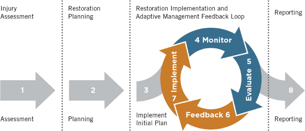
the MAM framework “may be more robust for some elements of the restoration effort with higher degrees of uncertainty, or where large amounts of restoration are planned within a given geographic area and/or for the benefit of a particular resource” (DWH Open Ocean Trustee Implementation Group, 2020, p. 4; see also DWH NRDA Trustees, 2016). Importantly, the adaptive management feedback loop provides the trustees with the opportunity to adjust restoration actions as needed, based on monitoring and evaluation of restoration outcomes (DWH NRDA Trustees 2016, 2017a, 2019, 2021). Data from completed projects can inform future restoration efforts. The adaptive management approach developed by the trustees provides the ability to make refinements to wetland restoration projects and programs as more information becomes available over time. The approach supports using the latest scientific data to inform how to improve future wetland restoration decision-making processes, including predicting and/or measuring the influence of external factors (e.g., sea level rise, tropical storms or hurricanes) on restoration outcomes, characterizing interactions among restoration actions, and collecting additional data needed to support regional-scale restoration (Hijuelos and Hemmerling, 2015; Steyer et al., 2003).
Key considerations in an effective adaptive management approach when assessing the cumulative effects of multiple restoration efforts include monitoring that is sufficient to detect environmental change associated with the restoration effort (Westgate et al., 2013) and to assess the potential effects of long-term environmental trends; evaluation and synthesis of monitoring data from multiple projects and background environmental trends to assess impacts on cumulative effects; feedback and learning by which the information obtained through the synthesis of the monitoring data is used to adapt future project plans; and implementation to determine and administer an appropriate remedial action or course correction. The cycle is then repeated as needed.
When applied to individual restoration projects, such as those associated with DWH, use of an adaptive management monitoring framework allows restoration to proceed in the face of uncertainty. Earlier sections of this report highlight the many uncertainties restoration efforts face within the GoM, such as effects from climate change, relative sea level rise, long-term environmental trends, and variability of freshwater discharges. Adaptive management provides a critical framework in which these uncertainties are integrated into assessment of restoration success within the Gulf and provides for adjustment in restoration approaches if the initial plan does not make progress in attaining restoration objectives. NASEM (2017) found that adaptive management is most suited for situations where environmental conditions may respond to management actions (restoration projects meet this qualification), where there is considerable uncertainty regarding the response, where reducing that uncertainty could improve decisions regarding the project, or where stakeholders are committed and have the capacity to sustain an adaptive management approach.
To date, guidance for individual restoration projects supported by DWH recovery funds include monitoring plans that incorporate adaptive management as part of their approved project plans and monitoring to be conducted in accordance with those plans. However, as noted above, data and results from the projects completed to date are sparse or not currently accessible, and the evaluation step of the cycle does not appear to have been implemented or disseminated beyond the individual-project scale.
At the project scale, the use of adaptive management for DWH-funded projects has been infrequently documented. In one example, when evaluating the progress of a seagrass planting restoration project in Santa Rosa Sound, Florida, project scientists determined that it was necessary to erect temporary fencing to exclude rays and blue crabs that were uprooting newly planted seagrass as a result of their feeding on benthic infauna. From studies in other regions (Thom et al., 2005), crabs are known to disrupt seagrass plantings through foraging and burying. The fencing allowed the plants to become established, although disturbance by tropical storm activity also hindered the overall success of the project (Heck and Byron, unpublished report). The potential for applying an adaptive management approach to larger spatial scales (including Gulf-wide) is discussed in Chapter 5.
GULF-WIDE SYNTHESIS: AN EXAMPLE
During information-gathering sessions for this report, several GoM stakeholders and project managers noted that while there is a need for Gulf-wide cumulative assessments of restoration efforts, incentives and resources are not currently in place to achieve this goal.24 Gulf-wide synthesis activities have been recommended since at least 2017 (NASEM, 2017).
A recent assessment of meta-analyses of lag times between restoration implementation and the development of associated benefits (summarized in Carle et al., 2020) provides an example of how synthesis can inform future restoration and monitoring efforts. The duration of the monitoring period needed to evaluate the effectiveness of a restoration project varies depending on the habitat type(s) involved, the restoration outcomes that are being evaluated, and factors specific to each location. Table 4.5 presents representative time periods that have been reported by literature reviews and meta-analyses of restoration projects in the GoM (e.g., Armitage, 2021; Baumann et al., 2020; Carle et al., 2020; Ebbets et al., 2020; Hollweg et al., 2020; Rezek et al., 2019).
In restored coastal marshes, attributes such as plant cover and use by fauna as spawning and nursery habitat can become well established within 1–5 years following restoration, while other features, such as below-ground biomass, soil organic content, and trophic functions (such as benthic infauna densities), may need a decade or more to approach levels typically observed in natural marshes (Baumann et al., 2020; Carle et al., 2020; Ebbets et al., 2020). In contrast, restored oyster reefs “tend to demonstrate rapid development of both ecosystem structure and function, as long as they are located in environmental settings with suitable salinity, water quality, and oyster larval transport” (Carle et al., 2020, p. 1682).
In the case of SAV restoration, time lags and outcomes can vary depending on the scale of the restoration effort. At the project scale, where the goal is to establish individual SAV beds using transplanting or seeding techniques, outcomes tend to be somewhat binary, either failing rapidly at sites where water clarity or other environmental factors do not support SAV survival or showing long-term persistence and growth at sites where SAV needs are adequately met (e.g., Rezek et al., 2019). In successful project sites, nekton and epifauna can colonize quickly and reach abundances and species composition that resemble natural SAV beds in 1–2 years (Carle et al., 2020). At larger sub-estuary or estuary scales, SAV restoration has typically been achieved by improving water quality and water clarity to levels that meet SAV needs, resulting in natural SAV recruitment or expansion from existing beds (see Table 4.4 for examples). In such cases there can be multiyear time lags between the initial implementation of water quality improvement projects, typically focused on nutrient load reductions, and the establishment of water quality conditions adequate for SAV restoration. Once the necessary water quality conditions are met, there can be additional multiyear lags before seagrass cover and habitat function increase to target levels (e.g., Greening et al., 2014; Tomasko et al., 2018).
Following project implementation, long-term monitoring and assessment will be needed to track and (if possible) correct for impacts due to climate change; relative sea level rise (RSLR); and changes in hydrologic, sediment and nutrient loads. The information and references summarized in Table 4.5 can be used to inform long-term monitoring protocols needed to track restoration progress, cumulative effects of multiple projects, and assess impacts of background environmental trends.
Living shorelines are designed to provide shoreline stabilization and typically incorporate native materials, such as marsh vegetation, oyster, or mussel beds, or SAV, alone or in combination with some type of harder shoreline structure for added stability (NOAA, 2015a; Smith et al., 2020). After construction, living shoreline projects can reach ecological equivalency with reference marshes for habitat use by snails and herons within 2 years (Chambers, 2021; Guthrie et al., 2022) and can establish nekton within 3 years (Gittman et al., 2016). However, soil composition equivalency with natural marsh organic matter lag several to many years behind those associated with habitat use (Chambers, 2021; Isdell et al., 2021).
___________________
24 G. Grandy, J. Henkel, A. Hunter, G. Leonard, P. Mickle, J. Porthouse, and B. Sutter, presentations to committee, August 12, 2020.
TABLE 4.5. Observed Lag Times for Various GoM Habitat Restoration Approaches
| Habitat Type | Restoration Approach | Typical Spatial Scale | Outcomes Monitored/Assessed | Months | 1 Year |
2 Years |
3 Years |
5 Years |
10 Years |
20 Years |
30 Years |
References |
|---|---|---|---|---|---|---|---|---|---|---|---|---|
| COASTAL MARSH | Bathymetric modifications +/- planting | Project | Plant cover; above-ground biomass and faunal spawning; nursery habitat | Carle et al., 2020, and references therein | ||||||||
| Project | Below-ground biomass; soil organic matter, benthic infaunal and epifaunal density, production, and diversity; trophic support for nekton growth and development | Armitage, 2021, and references therein; Carle et al., 2020; Baumann et al., 2020, and references therein; Hollweg et al., 2020, and references therein; Ebbets et al., 2020, and references therein | ||||||||||
| OYSTER REEF | Placement of cultch/substrate | Project | Oyster density and reef structure; macrofaunal production and diversity; food web complexity | Carle et al., 2020, and references therein | ||||||||
| SAV | Planting (transplants/seeds) | Project | Plant cover and condition; above-ground biomass, nekton production, and diversity; benthos production/diversity | Carle et al., 2020, and references therein; Rezek et al., 2019 | ||||||||
| Water quality restoration and management | Sub-estuary/Estuary | Plant cover, condition, and biomass; nekton production and diversity; benthos production and diversity | Greening et al., 2014; Sherwood et al., 2016; Beck et al., 2020; HARC, 2020; GBEP, 2018; Tomasko et al., 2018 |
NOTE: Bathymetric modifications include dredged sediment placement, thin-layer sediment enhancement, and excavation of upland areas. Lag times between restoration implementation and functional equivalency of 3 years or less are shown in yellow shading; green shading indicates lag times of more than 3 years. GoM, Gulf of Mexico; SAV, submerged aquatic vegetation.
INTEGRATING CUMULATIVE EFFECTS AND ADAPTIVE MANAGEMENT INTO RESTORATION: NEXT STEPS
As noted above, cumulative effects at the estuary and sub-estuary scales have been observed in the GoM, but extensive and prolonged monitoring efforts were necessary for detection. Additionally, the strength of large external environmental drivers, pressures, or stressors (such as seal level rise or hurricanes) and the relatively small amount of area restored may have prevented the detection of beneficial effects of cumulative restoration at the Gulf-wide, regional, or state levels.
To better ensure detection of cumulative effects in restoration, several steps could be taken. At the project level, they could include identifying project-level metrics to support assessment of effects on a broader scale, utilizing consistent methodologies for collection and reporting of project-level metrics and ensuring that data are freely accessible and that metrics are available to facilitate assessment. At other levels, steps could include identifying other metrics or datasets that could support cumulative effects assessments, but may not be readily collected at the project scale. These include non-DWH restoration programs that are collecting data across large spatial and temporal scales.
Figure 4.3 outlines an approach for planning, implementing, assessing, and synthesizing cumulative effects of multiple restoration efforts in a defined geographic area. The use of an adaptive management strategy allows progress on implementation of restoration efforts to continue, even if all necessary information is not immediately known. For example, Step 2 asks whether adequate baseline environmental conditions are sufficiently known to assess change; if not, this step provides for the development of preliminary baseline estimates using existing data sources (Step 2a) that can be used to continue toward implementation. The adaptive management feedback loop allows reevaluation and adjustment of the restoration strategy as additional data and information are collected on environmental conditions, performance metrics, and comparison with baseline conditions.
Key elements of the multiple lines of evidence discussed in Chapter 3 are used throughout this approach. In Step 1, the conceptual model incorporates potential synergistic and antagonistic effects, hot spots and hot

moments, and background trends, and develops restoration hypotheses. Step 2a uses historic data sources and literature review to help fill information gaps and allows progress to continue. Development of the restoration strategy in Step 3 can take into account one or more lines of evidence. Synthesis of changes in landscape-scale monitoring data to test restoration hypotheses and the use of data-driven models (see Chapter 3) are key elements in Step 4. Step 5 assesses the adequacy of existing lines of evidence and data to make restoration strategy decisions. The cycle is then repeated if necessary, starting with revising the original conceptual model with new information.


