
Chapter 5
Moving Forward
INTRODUCTION
Calls for providing the scientific efforts (monitoring, modeling, and research) needed to support an adaptive management process for Deepwater Horizon–funded restoration efforts are not new. In 2011, the Gulf Coast Region Ecosystem Task Force developed a shared vision for the Gulf Coast, to “achieve a resilient, healthy Gulf of Mexico ecosystem that supports the diverse economies, communities and cultures of the region” (Gulf Coast Ecosystem Restoration Task Force, 2011, p. 10). The authors note that achieving this vision has to include alignment of activities among the federal government and states, as well as collaboration in order to create realistic goals for restoration. In 2012, the Gulf Coast Ecosystem Restoration Task Force (GCERTF) Science Coordination Team developed a science plan (Walker et al., 2012) for cross-cutting monitoring, modeling, and research efforts needed to provide the basic science infrastructure to support the overall vision for the Gulf of Mexico (GoM) restoration program. A specific objective of the plan called for the development of an iterative and flexible approach to allow adaptive management and decision-making. In addition, Brown et al. (2011) recognized that, because the GoM ecosystem contains many political boundaries, coordination across geographic and organizational lines would be needed, and recommended that strategies be implemented at the largest scale possible.
As discussed in Chapters 2–4, significant progress has been made since 2012 in advancing monitoring and modeling capabilities1 (Deepwater Horizon NRDA Trustees, 2017a; NOAA and USGS, 2019). Still, new technologies (such as sensor networks) and involvement of nontraditional partners (such as citizen/community scientists) offer opportunities for further advancement. Long-term environmental trends for some environmental parameters and species are now available at local and regional scales, though data collection, analysis, and reporting are often inconsistent, and existing efforts are not adequate to detect all important Gulf-wide trends.
Significant challenges remain in the development of the critical analysis and synthesis of the cumulative effects of Deepwater Horizon projects. Assessment of cumulative impacts—additive, synergistic, and possibly antagonistic effects—of multiple restoration projects of similar or diverse nature over spatial and temporal scales beyond that of an individual project are uncommon in the GoM. Development of synthesis capacity that can support an adaptive management process to integrate diverse restoration projects over significant spatial scales is recognized as a need by the Deepwater Horizon funding entities,2 but has not yet been widely initiated.
___________________
1 See https://www.gulfspillrestoration.noaa.gov/sites/default/files/2019-08%20MAM_Manual_Attachment_E_07_Marine%20Coastal%20Estuarine%20Riparian_Habitats_%20Monitoring_Guidance%202019.pdf.
2 As described in Chapter 1, when used in this report, the “Deepwater Horizon funding entities” are the RESTORE Council state and federal members (States of Alabama, Florida, Louisiana, Mississippi, and Texas; U.S. Department of Commerce; U.S. Department
This chapter discusses critical aspects that underpin progress in moving forward: (1) data needed to assess long-term environmental trends and their impact on restoration activities; (2) emerging monitoring strategies for large-scale multiproject restoration efforts; (3) how cumulative effects analyses and adaptive management approaches can be utilized in planning, implementing, and assessing future restoration efforts in the GoM; and (4) barriers and opportunities for synthesizing the large amount of data and information already collected from Deepwater Horizon projects to maximize the probability of successful ecosystem restoration in the GoM.
DATA RESOURCES FOR ASSESSING LONG-TERM ENVIRONMENTAL TRENDS
Possessing baseline and trend data for important environmental variables when evaluating restoration efforts provides fundamental support for the synthesis activities needed to inform adaptive management actions (Ellison et al., 2020; LoSchiavo et al., 2013; Thom, 1997). The committee’s assessment of the lack of data availability for monitoring background environmental indicators and trends is similar to that summarized previously by Love et al. (2015) and more recently by Carle et al. (2020). For example, Love et al. (2015) identified gaps in long-term monitoring that can be summarized in three overarching findings:
- There are many existing monitoring efforts that restoration decision-makers can use to track the recovery of injured natural resources. Building on these existing efforts will improve consistency, efficiency, and coordination.
- There are gaps in monitoring and in the understanding of natural resources in the Gulf that need to be filled to effectively evaluate recovery and thus the success of restoration programs in the Gulf ecosystem.
- Addressing the currently disjointed monitoring system and moving toward a Gulf-wide ecosystem monitoring network will provide a more efficient, integrated, and accessible tool for ecosystem information.
A collection of papers focused on the GoM, introduced by Carle et al. (2020), found that monitoring of restoration projects was often limited to a few years and focused on meeting specific construction targets (e.g., acres of marsh) or features (e.g., percentage of vegetation cover). In a specific example, they stated that “without more long-term monitoring data, natural variability makes it difficult to accurately predict restoration trajectories for some characteristics of restored marshes, particularly the extent to which slower developing functions might emerge over time” (Carle et al., 2020, p. 1685; see Table 4.5, in Chapter 4).
Although several national programs do provide consistent and accessible data, most environmental indicators are not monitored consistently, and datasets are fragmented spatially and/or temporally (GOMA Water Quality Team, 2013; Love et al., 2015). State and federal resource agencies collect long-term environmental monitoring data specific to their agency and state missions, and this information could be useful for assessing cumulative impact of multiple restoration projects at estuarine or larger scales. The RESTORE Council Monitoring and Assessment Program (CMAP) developed an inventory of existing habitat and water quality monitoring, and mapping metadata for the GoM programs, which includes links to electronically available datasets (NOAA and USGS, 2019). However, efforts to access and synthesize data are hampered by the lack of unifying GoM analysis and synthesis activities for many key stressors (e.g., ocean and coastal acidification, hypoxia, tropicalization). No entity that the committee could identify has the resources and the explicit responsibility to synthesize data from multiple sources. This type of analysis and synthesis activ-
___________________
of the Interior; U.S. Environmental Protection Agency; U.S. Department of Agriculture; U.S. Coast Guard; and U.S. Department of the Army); the Deepwater Horizon NRDA Trustees (National Oceanic and Atmospheric Administration, U.S. Environmental Protection Agency, U.S. Department of the Interior, U.S. Department of Agriculture, and the five Gulf states); the National Fish and Wildlife Foundation Gulf Environmental Benefit Fund; the U.S. Fish and Wildlife Service North American Wetlands Conservation Fund; the Centers of Excellence; the NOAA RESTORE Science Program; and the Gulf Research Program.
ity, so essential for accurate assessments of cumulative effects of large-scale restoration activities, remains to be undertaken.
Monitoring Challenges Faced by Program Managers
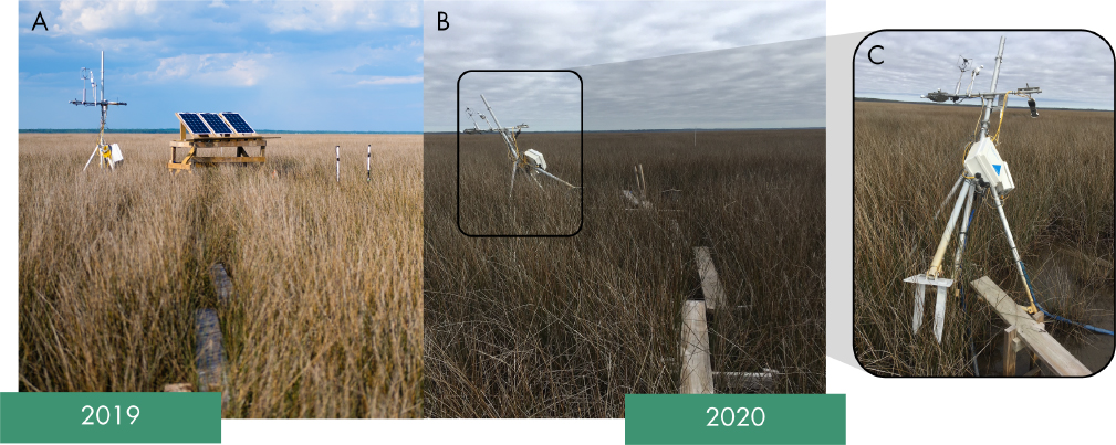
Chapters 3 and 4 discuss a detailed framework with case studies on cumulative effect assessment of multiple GoM restoration projects. Such a framework, a foundation for Gulf-wide synthesis studies, is built on the assumption that comprehensive monitoring datasets are acquired regularly during and after restoration, and data are freely available and accessible. However, establishing a comprehensive monitoring program is not easy and can face logistical, technical, and economic challenges (e.g., Biber, 2013). Increasingly intense hurricane seasons (e.g., Holland and Bruyère, 2014) can disrupt established monitoring programs, destroy expensive field equipment (as shown in the example in Figure 5.1), deny access to field sites, and distract program managers with other urgent priorities (Kozlov, 2021). After a hurricane, program managers have to partially or entirely resurrect the monitoring effort with new locations, equipment, and sampling protocols (e.g., Burke, 2018).3 For example, in 2018, the Gulf Research Program of the National Academies of Sciences, Engineering, and Medicine funded 22 small grants to help with repair, replacement, or recovery of equipment, data, and research material incurred from Hurricanes Harvey and Irma (NASEM, 2019).
As documented in Chapter 2, access to long-term monitoring data is limited, and the data are often dispersed among many agencies, states, and local entities. CMAP compiled an inventory of 544 water quality monitoring, habitat monitoring, and mapping programs operating in the GoM (NOAA and USGS, 2019). The authors found that accessible metadata was commonly missing from monitoring programs and recommended monitoring programs invest in making metadata web accessible (NOAA and USGS, 2019).
The following sections examine emerging technologies as potential solutions to avoid data discontinuities. These technological solutions are in addition to traditional field-based data collection discussed in Chapter 2. These technologies are not meant to replace well-established field-based monitoring programs developed through decades of research, but to complement them. Some of these technologies are already being used in the GoM. Many of the proposed sensing frameworks and sensor devices, towers, and networks
___________________
3 This phenomenon was also described by Gregory Steyer of the U.S. Geological Survey (personal communication, October, 11, 2021).
are also prone to technical and communication failure, miscalibration issues, and damages by natural disasters, but repairing, replacing, and reestablishing these monitoring devices may be easier, faster, and more economically viable than the replacements needed in field-based sampling programs (Biber, 2013).
Emerging and Novel Monitoring Strategies and Techniques
Recent advancements in data-driven techniques—such as artificial intelligence (AI), machine learning (ML), and deep learning (DL)—as well as cloud and edge computing are expected to fundamentally transform many domains of human endeavor, including post-restoration monitoring.4 Traditional remote sensing combined with new sensing technologies and AI-driven techniques can generate high-quality long-term monitoring data across terrestrial and coastal ecosystems5 (Corbane et al., 2015; Ridge et al., 2020). Although some large-scale remote sensing studies to monitor GoM-wide water quality and wetland habitats have been conducted in the past (Chen and Hu, 2017; Ghosh et al., 2016; Hu et al., 2011; O’Connor et al., 2016), few examples of integrated remote sensing and emerging technology-driven monitoring studies (e.g., using AI, ML, or DL) are being adopted for Gulf restoration efforts: for example, the CMAP inventory assessment found that only 7 percent of oyster restoration efforts used AI or ML (NOAA and USGS, 2019).
It is clear that transformational changes in capturing, recording, transmitting, synthesizing, archiving, and extracting meaningful physical, chemical, biological, and ecological data and information about restoration projects across GoM are needed from multiple sources, users, and scales. As environmental monitoring data generated using these techniques will most likely be heterogeneous—textual, numerical, or spatial—models or synthesis tools will need to be capable of handling a variety of data for predicting ecosystem responses to restoration activities (Peters et al., 2014; Peters-Lidard et al., 2017; Zhong et al., 2021). These newer data-driven frameworks are not expected to replace traditional restoration science–driven ecosystem monitoring, but complement and strengthen them. The ecosystem restoration and monitoring community could benefit from using a hybrid method, combining traditional approaches with new advanced tools, techniques, and partners. Such changes will likely apply to all aspects of the long-term trend monitoring framework, including data collection, modeling (making predictions, analyzing trends, and detecting anomalies), and synthesizing and disseminating information.
Field-based monitoring and sensing technologies have grown substantially in the past decade, driven by advancements in cloud computing, crowdsourcing or crowdsensing, AI, plug-and-play sensors, low-cost computer boards, drones, and small satellites.6 Use of these advanced multiplatform sensing technologies and data analytics and visualization methods can make post-restoration monitoring targeted, effective, inexpensive, and sustainable over long time frames (Corbellini et al., 2018; Mayton et al., 2017; Rundel et al., 2009). To employ these methods of data acquisition effectively, a comprehensive, multifaceted approach, such as those that already exist and are being increasingly implemented in ecosystem monitoring studies, will need to be adopted. For example, the GoM restoration science and practitioner community could adopt the AI-integrated Cyber-Physical Systems (CPS) framework of the National Science Foundation (NSF) to develop innovative ways to acquire, process, visualize, and share data for long-term monitoring of restoration sites and to assess the cumulative impact of projects. CPS is defined as “engineered systems that are built from, and depend upon, the seamless integration of computation and physical components.”7 The physical component in CPS could be a restored site, such as a salt marsh, bay, seagrass meadow, or oyster reef, or include a larger area, such as multiple restored sites across a landscape. The three components of long-term monitoring and assessment would involve acquiring multiple heterogeneous environmental data from the site; transmitting and processing those data; and modeling, visualizing, and disseminating map
___________________
4 See https://www.microsoft.com/en-us/ai/ai-for-earth.
5 See https://coastalresilience.org/project/ai-conservation/; https://salo.ai.
products to end-users or data contributors (in the case of crowdsensing) (e.g., Mishra et al., 2020; Nundloll et al., 2019). Once set up, a CPS system can be automated to save time and reduce costs.
Implementing such a framework across restoration sites and states is predicated on a willingness to adhere to the open data concept, such as the White House’s Climate Data Initiative8 and the Open Data Portal of the National Oceanic and Atmospheric Administration (NOAA)9 (Peters, 2010; Schmidt et al., 2016), which means data are accessible and available to be repeatedly used in modeling and analysis. Another integral part of such a framework is the use of AI-based data-centric environmental models based on ML and DL (LeCun et al., 2015; Zhong et al., 2021). As noted in the Executive Order on maintaining American leadership in AI,10 ML and DL have the potential to drive growth and innovation in many fields, including coastal ecosystem science. However, to date, the coastal environmental restoration field has only minimally integrated or adopted ML and DL in modeling and data synthesis activities because of such challenges as large training datasets, data labeling, and computation needs (Lamba et al., 2019).
AI-based models capable of highlighting the complex nonlinear relationships between restoration activities and ecosystem response (structure and function) need to be at the forefront of tool creation because they can isolate the cumulative impacts of long-term restoration projects and can be used for large-scale synthesis across sites in the GoM that are under the constant influence of broad-scale natural and anthropogenic drivers, pressures, and stressors. AI-based modeling with existing monitoring data has been increasingly used in the past few years but primarily for smaller-scale projects (Beijbom et al., 2015; Norouzzadeh et al., 2018; Parashar et al., 2021; Weinstein, 2018; Williams et al., 2019). Its use in large-scale, long-term monitoring projects has been rare.
The sections below describe the types of data, ecosystem variables, models, and visualization tools that could be helpful in advancing a cost-effective, easily implementable, easily adoptable monitoring framework in the GoM.
Multisource Monitoring Data
Remote Sensing Satellites
Monitoring coastal environments using point-based field data can be time-consuming, expensive, and spatially unrepresentative or inadequate to characterize long-term trends. To overcome these difficulties and conduct site- and regional-scale monitoring and mapping, remote sensing satellite data are often used (NASEM, 2015, 2018c). Depending on the environmental variables being monitored, restoration practitioners have access to open-source satellite data ranging from 10 m to tens of km in resolution. Very high-resolution11 multispectral image data (1–3 m) from commercial satellites—such as PlanetScope (3–5 m), IKONOS (4 m), QuickBird (2.4 m), and WorldView-2 and -4 (1.24–4 m)—have been available since the 2000s. However, they are expensive and often cost-prohibitive for long-term time-series analysis, and the highest-resolution data is not always best suited to the research question (Ghosh et al., 2016). National Aeronautics and Space Administration (NASA)12 and European Space Agency (ESA)13 satellite imageries are available in an open-source form and represent a wide range of data from passive and active sensors, including multispectral sensors (e.g., Landsat, MODIS, Sentinel-2 and -3), Light Detection and Ranging (LiDAR) sensors (e.g., ICESat-2), and Interferometric Synthetic Aperture Radar (InSAR) sensors (e.g., Envisat). These are typically considered moderate-resolution (10 m to 1 km) satellites useful for various local and regional analyses.
___________________
8 See https://www.data.gov/climate.
9 See https://odimpact.org/files/case-studies-noaa.pdf.
10 Executive Order 13859 (February 11, 2019): https://www.federalregister.gov/documents/2019/02/14/2019-02544/maintaining-american-leadership-in-artificial-intelligence.
11 See https://www.satimagingcorp.com/satellite-sensors.
In the past few years, there has been substantial growth in the number of small satellites, or CubeSats, launched to the lower earth orbits that provide remote sensing images at various resolutions14, 15 (NASEM, 2016; Stephens et al., 2020). One of the prominent examples is the Planet Lab’s CubeSat constellations consisting of roughly 150 CubeSats with the goal of imaging the whole Earth daily at a spatial resolution of 3 m.16 These kinds of high-temporal-frequency data have the potential to be valuable in monitoring the impact of acute disturbance events, such as hot spots and hot moments (see Chapter 3), on restoration sites in the GoM. There are now numerous satellite options for acquiring imaging data from a specific restoration site or for multiple restoration projects, and the choice of satellite sensor and data depends on the nature of the investigation, type of data needs (e.g., spatial resolution or pixel size; optical imagery, thermal imagery, or elevation or height data), frequency of acquisition (daily, weekly, monthly), and environmental constraints (e.g., cloud cover, tide height). When multiple datasets from different satellite sensors are available, cross-calibrated models can be developed (Liu et al., 2021b; Page et al., 2018), which means the general model will work for multiple satellite datasets without requiring satellite-specific calibration. These cross-calibration techniques can help maintain long-term trend monitoring, even if a specific satellite used in the analysis gets decommissioned.
Uncrewed Aerial Systems
In the past few years, uncrewed aerial systems (UASs) have become ubiquitous in environmental data collection (NASEM, 2020). The most common types of UASs for remote sensing observations offer multispectral (tens of bands) imaging and thermal imaging.17 Although hyperspectral (hundreds of bands) UASs exist, they tend to be expensive and are not now commonly used, though applications for their use in post-restoration monitoring of habitat and fisheries are in development (Roegner et al., 2019). UASs offer several advantages that satellites currently do not, such as the flexibility of when and how to fly, which is essential to control the data quality in terms of scale, resolution, and environmental constraints. UASs can fill in the temporal gaps created by satellite-based monitoring, offering very detailed mapping of ecosystem structures that satellites often miss (Emilien et al., 2021; Evans Ogden, 2020). They are often used to scale-up ground-based models to an intermediate scale before implementing them on satellite data (Emilien et al., 2021). The use of UASs in environmental monitoring has increased in the past few years, but standardization in data processing and analysis has not caught up.
Autonomous Underwater Vehicles
The use of autonomous underwater vehicles (AUVs) has increased dramatically in the past decade as a way to collect essential ocean variables, such as temperature, salinity, oxygen, nutrient, pressure or depth, and benthic cover or topography, at a fine spatiotemporal scale (Barrett et al., 2010; Joint Nature Conservation Committee, 2018; Whitt et al., 2020). Advancement in technologies in communication and operation autonomy has made it possible for these AUVs to acquire comprehensive environmental datasets, which can be ingested by existing marine observation systems, such as the Global Ocean Observing System (GOOS)18 and the Gulf of Mexico Coastal Observation System.19 ML, DL, and intelligent remote sensing systems are now commonly embedded into AUVs, enhancing their environmental perception (e.g., DeeperSense Project20) and allowing them to optimize their path to collecting data from areas with environmental anomalies (e.g., algae blooms, thermal hotspots, hypoxic zones, coral die-off areas) (Paull et al., 2013; Wynn et al., 2014; Whitt et al., 2020). However, operations in nearshore coastal waters are affected by such factors as shallow depths, turbidity, tides, and submerged and emergent vegetation: AUVs have not necessarily been engineered or widely adopted for these applications (e.g., Watson et al., 2020).
___________________
14 See https://www.jpl.nasa.gov/cubesat.
15 See https://www.nasa.gov/mission_pages/cubesats/overview.
16 See https://www.planet.com.
17 See https://conservationdrones.org.
18 See https://www.goosocean.org.
Ground Sensor Networks
Ground- or field-based imaging and nonimaging sensors can be an accurate source of field monitoring data, which can be integrated and matched with drone and satellite data (Babaeian et al., 2019; Mishra et al., 2020). Field sensors are becoming increasingly cheaper and versatile (Mao et al., 2019). They can be seamlessly integrated into inexpensive computer boards, such as Raspberry Pi or Arduino (Mao et al., 2019; Ojha et al. 2015; Prasad, 2015) and solar panels to automate data collection, storage, and transmission (Boddula et al., 2017). The imaging or optical or wireless sensors can provide multi- and hyperspectral remote sensing reflectance data, which can be used to monitor wetlands’ biophysical characteristics, soil organic matter, water quality, seagrass status, and several other coastal habitats or ecosystem indicators (Babaeian et al., 2019; Boddula et al., 2017; Geller et al., 2017; Mishra et al., 2020; Ojha et al. 2015; Prasad, 2015; Quinn et al., 2010; Rundel et al., 2009; Sadinski et al., 2018). Field-based cameras, such as the PhenoCam or wildlife cameras, can be valuable tools to provide geocoded image data from a site21 (O’Connell and Alber, 2016; Richardson et al., 2018). Other sensors—such as CO2 sensors mounted on eddy flux towers, nutrient sensors, soil sensors, floating water quality sensors (for conductivity, temperature, depth) and other buoy-based sensors, and temperature and water-level sensors—can also be useful in monitoring coastal estuarine ecosystem properties ( Jones et al., 2019; Moore et al., 2009; Nehir et al., 2021; Yan et al., 2008).
Crowdsourcing or Crowdsensing
Crowdsourcing/crowdsensing22 has been an increasingly effective tool used in many types of environmental monitoring (Ghermandi and Sinclair, 2019). Inviting members of the public to contribute meaningful environmental data and disseminating the spatial or map products generated from those datasets back to the people as information create meaningful incentives that can keep community scientists motivated to sustain the data collection and sharing feedback loop (McKinley et al., 2017). In recent years, many projects have successfully used crowdsourced data and online social media for targeted and effective environmental monitoring: examples include the Enviro-Net project from the University of Alberta and IBM, the Aqueduct Project from the World Resources Institute,23 the Secchi Disk Project (Seafarers et al., 2017), the CyanoTRACKER project (Mishra et al., 2020), and Australian Fishes project.24 There is considerable interest in leveraging community scientists or the public at large, including residents, tourists, and environmental advocates, by enabling and encouraging them to contribute observational data (de Sherbinin et al., 2021). The proliferation of smart mobile devices, online social media, and cloud computing has significantly lowered the barrier for nonscientists to participate in environmental monitoring (LeCun et al., 2015). Since the advent of social media platforms and microblogs, crowdsourcing and community science activities have been revolutionized, and researchers have used the crowd-sensed data for detecting all sorts of ecological, environmental, and geological phenomena, such as vegetation health, coastal flooding, plant and animal identification, earthquake and landslide damages, and urban temperatures (e.g., Earle et al., 2012; Mishra et al., 2020; Scott et al., 2016). Community science and crowdsourced data could be valuable in providing firsthand information about coastal habitats, species, or disturbance impacts if there is proper infrastructure in place, such as reporting mobile apps, information about participation on- and off-site, and incentivizing participation (Cigliano et al., 2015; Kelly et al., 2020).
Automated Data Collection and Transmission
New avenues for environmental data collection discussed above can create an opportunity to supplement traditional approaches to environmental monitoring. Once set up, these systems can be relatively
___________________
21 See https://phenocam.sr.unh.edu/webcam.
22 Crowdsourcing is data that is collected by nonprofessionals, such as community members and stakeholders, instead of scientists and government agencies (e.g., Conrad and Hilchey, 2011), while crowdsensing uses devices to collect field data.
23 See https://www.wri.org/aqueduct.
24 See https://australian.museum/get-involved/citizen-science/fishes.
autonomous and inexpensive to operate and eliminate the need for frequent field travel or physical sample collection. Being able to collect automated data from relatively isolated restoration sites by remotely operating the sensors from a laboratory using AI technologies and guaranteeing reliable transmission of monitoring data from these environments (e.g., coastal marshes) is one of the most important features of the NSF CPS infrastructure. Restoration project managers could further explore automated data collection using feasibility studies with quality assurance and quality control procedures in place for cross-validation with occasional field data, as recommended in Louisiana’s 2015 System-Wide Assessment and Monitoring Program (SWAMP) report (Hijuelos and Hemmerling, 2015) and currently under way in the Columbia River estuary restoration (Roegner et al., 2019). It can ultimately be a cost-effective way to address postrestoration monitoring challenges. Various data transmission approaches are available, such as data hopping via WiFi, 4G/5G mobile network–based data transfer, and transmission via low-earth-orbit satellite communication datalinks, such as the Iridium satellite constellation25 (Alpert et al., 2016; Hart and Martinez, 2015; Zhang et al., 2019).
Data-Driven Modeling to Ingest Heterogenous Monitoring Output
Environmental models, in the form of conceptual or physical models or ecosystem, population, or mechanistic models, and landscape or rule-based models (discussed in Chapter 3) have been used traditionally to model cumulative impact assessment in terms of environmental biophysical and biochemical characteristics and ecosystem responses. They can be effective when accurately parametrized with high-quality field data derived from field sample analysis or controlled monitoring. However, with the new technology-driven sensing and monitoring techniques discussed above, the available data will be heterogeneous and inherently noisy (e.g., multisource sensing data, spatial and remote sensing data, and numerical and contextual data) (Clark and Gelfand, 2006; Goldstein and Coco, 2015; Peters et al., 2014; Peters-Lidard et al., 2017; Zhong et al., 2021). Using these new datasets, modeling the complex and nonlinear relationships between ecological variables and post-restoration ecosystem responses over space and time within the traditional modeling approaches can produce large uncertainties (Clark and Gelfand, 2006; Zhong et al., 2021). ML- and DL-based models (e.g., convolutional neural network or recurrent neural network) are increasingly widely used alternatives that can handle heterogeneous monitoring imaging and non-imaging data for model training and tuning (Lamba et al., 2019; Zhong et al., 2021). They can be highly effective in teasing apart the complex relationships between ecosystem drivers, pressures, and stressors and response and patterns between different datasets and environments, although their performance depends on the types and amounts of training data available from a site (Goldstein and Coco, 2015; Lamba et al., 2019). Once trained for a site across a wide range of variables, they can be used for a long time without needing frequent re-training (Sejnowski, 2020). They can also be scaled up to airborne and satellite sensors for large-scale and long-term monitoring and modeling (Lapenna and Soldovieri, 2021). The data-driven models will not replace traditional environmental models, such as physical or mathematical or simulation models, but will strengthen them when used in a hybrid framework (Clark and Gelfand, 2006).
Ensemble ML is a modeling framework in which several ML models or coupled physical, ecosystem, and ML models are run using environmental input variables either obtained from monitoring processes (as described above) or estimated using traditional environmental modeling, and their output is combined using a rule-based algorithm (e.g., stacking or voting; sometimes referred to as meta-learning) to generate the most accurate prediction (Finn et al., 2017; Sagi and Rokach, 2018). These types of data-centric models are progressively becoming a go-to modeling tool for the ecology and environmental science community for building assessment and predictive models (Beijbom et al., 2015; Norouzzadeh et al., 2018; Parashar et al., 2021; Peters et al., 2014; Weinstein, 2018; Williams et al., 2019). New refinement procedures for improving the predictive ability of these models are available in an increasingly open-source manner (Ghannam and Techtmann, 2021). This modeling framework can contribute to assessment of the long-term cumulative effects of large--
___________________
scale GoM restoration projects, along with other methods that support synthesis, such as literature review and simulation modeling (Chapter 3) and comparative analysis and time-series analysis (Chapter 4).
Open-Source Data for Visualization and Sharing
Accessibility to data, maps, and information is at the heart of the concept of open science.26 Access to data can be the biggest bottleneck for large-scale synthesis studies or comparative studies across restoration sites (e.g., de Groot et al., 2010; Farley et al., 2018; Palomo et al., 2018). Data transparency (such as types, collection and analysis procedure, uncertainty) and access and sharing mechanisms (e.g., open-source archive or web mapping tools) have to be determined in the early stages of each restoration project to facilitate future modeling and synthesis studies. An open-science framework adopted by the restoration practitioners and government agencies across the GoM in the form of openly accessible and comprehensive monitoring databases could help transform the post-restoration monitoring process to study long-term cumulative impacts. The primary objective would be to create a centralized online location where any user can visualize and download relevant data and products (e.g., imaging, nonimaging, community science). A diverse set of end users (such as environmental managers, researchers, nongovernmental organizations, policy makers, and commercial and recreational users) could visit the site to explore the available products and write custom code, if needed, to use these products in further analysis. There are several efforts under way across the Gulf states to either enhance existing open-source databases and online mapping interfaces or establish new ones capable of synthesizing monitoring data. Some examples include the Gulf of Mexico Research Initiative (GoMRI)’s Information and Data Cooperative (GRIIDC),27 NOAA’s Gulf of Mexico Data Atlas,28 the Gulf of Mexico Coastal Ocean Observing System (GCOOS),29 the U.S. Army Corps of Engineers’ Institute for Water Resources Gulf of Mexico Regional Assessment for the National Shoreline Management Study,30 the hydrologic and dnvironmental databases of the U.S. Environmental Protection Agency (EPA) and the U.S. Geological Survey (USGS), and the Tampa Bay Estuary Program’s reporting and assessment methods.31 These databases are important sources of input data, but they lack the ability to integrate models to synthesize, process, and display outputs about restoration projects across the GoM. Recent growth in cloud-based platforms—such as Google Earth Engine,32 which is open to anyone with an internet connection—can be an interface for users to model and visualize data, and carry out further processing (e.g., Boothroyd et al., 2020; Campbell and Wang, 2020; Mishra et al., 2020; Vos et al., 2019). The Google Earth Engine platform does not need local computing resources or specialized software, and users can perform several analyses, which may include empirical or data-driven modeling, mapping, and time-series trend analysis of multiple restoration sites, at once. These analyses are important components contributing to the lines of evidence and synthesis used for postrestoration cumulative effects (see Table 3.3, in Chapter 3).
Data Repositories
It is important that all data and information regarding restoration be available to all users, regardless of where data are deposited. FAIR principles—Findable, Accessible, Interoperable, Reusable (e.g., Wilkinson et al., 2016)—are widely accepted and provide guidance for data management and stewardship. In addition, many interim products and gray literature reports are scientifically peer reviewed and often contain more extensive datasets than those that are published in scientific journals. Including these products in data repositories allows them to be available to the greater community. To ensure that data and information
___________________
26 See https://en.unesco.org/science-sustainable-future/open-science.
27 See https://data.gulfresearchinitiative.org.
28 See https://gulfatlas.noaa.gov.
29 See https://gisdata.gcoos.org.
30 See https://www.iwr.usace.army.mil/Missions/Coasts/National-Shoreline-Management.
generated by Deepwater Horizon-funded restoration projects do not become lost or unavailable over time, data repositories need to ensure the following:
- FAIR principles are followed,
- multiple data formats and types (including video and audio formats) are accepted,
- data and metadata submissions are reviewed for completeness,
- an easy-to-use submission process is available,
- training and assistance for data providers (including planning, organizing, documenting, and submitting datasets) is provided,
- detailed geographic data are available to enable spatial searches,
- Digital Object Identifiers (DOIs) are assigned to datasets so they can be cited,
- datasets linked to publications are easily identified,
- data are freely available and downloadable,
- data are retained permanently in an archiving database,
- metadata are discoverable through common search engines, and
- data reporting formats are machine readable.
The broad set of restoration efforts envisioned by Deepwater Horizon funding entities and others, both coastal and oceanic, will generate significant quantities of data over the coming years. The amount of data that already exists is not insignificant, but it can be difficult to find and access and may need curation to meet the standards listed above. Much of the data is in diverse formats, which need to be stored appropriately. As ML, DL, and AI advance problem-solving approaches across both research and industry (e.g., Kersting, 2018), it is important to ensure that all restoration data are accessible to innovative approaches and contribute to adaptive management needs.
Table 5.1 summarizes example project-level parameters that could be useful for cumulative effects assessment for key restoration types being implemented since Deepwater Horizon (including oysters, submerged aquatic vegetation, salt marshes and mangroves, water quality and nutrient reduction, and birds). Both traditional parameters (discussed in Chapter 2) and novel techniques and emerging technology (discussed in this chapter) are included, as well as examples of cumulative effects assessment tools (discussed in Chapter 3). Key considerations regarding scale that might be important when designing and assessing project-level restoration efforts are also noted, for use by restoration managers.
KEY METRICS NECESSARY FOR ASSESSMENT BEYOND THE PROJECT LEVEL
Better understanding of the cumulative effects of multiple restoration projects is needed to ensure effective use of funding, sustainable restoration results, and demonstrable ecosystem benefits, along with other desirable societal goals. Assessing cumulative restoration is a focus of growing concern and analysis by the restoration community (Cooke et al., 2018, 2019; Ladouceur and Shackelford, 2021), as well as by funders and practitioners looking to advance restoration beyond project-level goals. Drivers and pressures (discussed in Chapter 2) affect restoration at both project and larger scales. Climate change generates pressures that, along with acute events such as hurricanes, affect all scales of restoration.
In the GoM, as with other developed coasts, anthropogenic drivers generate pressures (e.g., land use change, water management strategies) that can negatively affect restoration at all levels, further confounding synthesis activities (Magliocca et al., 2015). Monitoring the landscape-scale changes generated by these diverse drivers and pressures needs to be a priority moving forward, as those observations will support synthesis activities that inform adaptive management. This will include creating the metrics needed to assess restoration and the data needed to develop the metrics, and ensuring that data are compiled and made available to restoration planners in a useable form.
Key Indicators of Long-Term Trends Needed to Assess Restoration Efficacy
Numerous approaches and techniques are available for assessing the efficacy of GoM restoration activities, and clear and useful examples of synthesis have been completed or are under way in the Gulf region (e.g., Fennel and Laurent, 2018).33 Specific approaches and examples of synthesis activities completed in coastal and estuarine areas have been described in Chapters 3 and 4. The available approaches noted in Chapters 3 and 4 include mass balances (often called budgets), comparative analyses (use of data from many sites), time-series analysis (use of data collected over time at a site), and several types of simulation models (site-specific models and more general/conceptual models). These and other data-intensive approaches discussed earlier in Chapter 5 can readily be applied to the challenging issues of assessing restoration successes in the diverse habitats of the GoM when appropriate datasets can be accessed.
Metrics and data availability for tracking long-term environmental background trends in the GoM have been discussed in Chapter 2. Of those, several are also key to assessing restoration efficacy at larger spatial scales, including the following:
- freshwater inflow (USGS flow gages) and water quality parameters, including nutrient concentrations (federal, state, or local water quality monitoring programs): these data are used to generate loading estimates to estuarine and coastal waters. Changes in nutrient loadings can be used to gage effectiveness of multiple nutrient reduction efforts within a watershed.
- land use and land cover (Landsat, MODIS, Sentinel-2 and -3, or other satellite imagery): these are used to track changes in coastal habitat areal extent; transformation of rural to urban land uses (for example); and connectivity between habitat types within watersheds and their receiving waterbodies. Changes in the areal extent of habitat types can be used to assess net changes from multiple and large-scale land conservation efforts.
- tide gage data and subsidence measurements: these are used to estimate local relative sea level rise.
- ocean and coastal acidification indicators, such as pH: these are essential for successful restoration and maintenance of commercially important shellfish.
Ambient water quality measurements: these are used to track light levels for key habitats, including submerged aquatic vegetation. Methods to assess chlorophyll a and total suspended solids using multi- and hyperspectral data have improved (Dou et al., 2018), allowing for their use in assessing stages of restoration in water quality condition (Boyer et al., 2009; Millette et al., 2019). Tracking chlorophyll a concentrations in estuarine and coastal waters over time has also been an effective method for assessing light availability for submerged aquatic and other benthic communities (Luo et al., 2020), and is associated with implementation of multiple nutrient reduction projects within larger watersheds (see Chapter 4).
Satellite data and models for assessing wetland change (Couvillion, 2021; Klemas, 2013; Taddeo et al., 2019): they may be useful tools for assessing restoration over significant spatial scales. Examples include mangroves (Lee and Yeh., 2009) and constructed wetlands (Li et al., 2020b).
Status and trends data for fish, birds, and marine mammals collected for treaty, regulatory, and management purposes in the GoM: these represent some of the most readily available long-term data and encompass significant spatial scales. These data can be useful metrics for integrating across broad political and ecological spatiotemporal scales when assessing ecosystem health and function beyond project scale. They include fish ( Jordan et al., 2010; Schrandt et al., 2021); birds;34 water birds (Ogden et al., 2014; Rajpar et al., 2018); and marine mammals (Bossart, 2010; Wells et al., 2004). These data, collected for multiple diverse objectives, can contribute to the development of various lines of evidence efforts to assess cumulative impacts of restoration across spatial scales.
___________________
33 This point was also made in a presentation to the committee by Gregory Steyer of the U.S. Geological Survey (November 9, 2020).
34 See https://gomamn.org.
TABLE 5.1. Measurement and Modeling Techniques to Support Cumulative Effects Assessments from Project-Level Restoration Efforts
| Restoration Approaches and Anticipated Outcomes | Parameters and Indicators | Cumulative Effects (CE) Considerations | |||
|---|---|---|---|---|---|
| Restoration Type | Example Project-Level Parameters Useful for CE Assessment | Other Example Parameters and Indicators | Example Toolbox for CE Applications | Key Considerations Regarding Scale | Novel Techniques and Emerging Technologies |
| Oysters | Density Mortality Areal dimensions Reef elevation (height) Shoreline change (living shorelines) |
Reef connectivity and reefs across habitat and salinity gradients Rates of shell and reef accretion |
Population models Conceptual models Indices |
Reef system scale (elevation; connectivity of system) Gulf of Mexico scale (density, overall area, average increase in reef elevation over time) Fluctuations in ecosystem conditions critical to survival (e.g., salinity, dissolved oxygen) may underscore the importance of assessing reef systems across salinity and habitat gradients with a goal of maximizing survival under a variety of conditions Landings data can provide some indication of oysters’ Gulf-wide distribution |
Autonomous underwater vehicles to monitor essential variables, such as temperature, salinity, oxygen, and benthic cover Machine learning (ML) and deep learning (DL) models implemented on satellite data for water quality monitoring |
| Submerged Aquatic Vegetation (SAV) | Areal extent Density Percentage cover and composition Survival Biomass Water clarity |
Proximity to other habitats Denitrification rates Biomass of benthos Light characteristics Changes in areal coverage Secondary production |
Cumulative Net Ecosystem Improvement Conceptual models Monitored reference systems |
For some SAV projects, a simple summation of SAV processes across the full GoM could be feasible. For example, using SAV coverage data (and composition and density data), apply local and, where needed, literature estimates of denitrification; sum across regions for an annual shallow water GoM estimate of nitrogen losses and compare with inputs to the GoM and to regions Time lags and measurable outcomes can vary depending on the scale of the project Large-scale efforts typically achieved via accompanying improvements in water quality and clarity |
Autonomous underwater vehicle with imaging sensors to monitor benthic habitat cover or percentage cover of SAV SAV habitat maps using ML and DL models on remote sensing images from uncrewed aerial systems or satellites |
| Wetlands (Salt Marshes and Mangroves) | Area of habitat restored, enhanced, created, or conserved Vegetation percentage cover and species composition Above-ground and belowground biomass Gross primary production |
Habitat connectivity and proximity to other habitats Changes in areal coverage Secondary production Additional process measurements, such as carbon sequestration and denitrification, are important in these systems and will need modeling and research community coordination and collaboration |
Physical models Cumulative Net Ecosystem Improvement |
Attributes, such as plant cover and use by fauna, can become well established within 1–5 years of restoration, while other features, such as belowground biomass, can take one or more decades to approach levels of natural marshes | Crowdsourcing for reporting marsh dieback or other degradations CubeSats high temporal frequency useful for monitoring impacts of acute disturbance events Ground sensor networks with automated data collection and transmission (e.g., Phenocam or eddy covariance towers) Moderate resolution multispectral satellite data for frequent monitoring of wetland biophysical status |
| Water Quality, Including Nutrient Reduction | Sediment, nitrogen, phosphorus loads; ambient pollutant concentrations Bacteriological indicators |
Likely will need quite a few process measurements (accretion rates, production rates, etc.) to develop useful models used to quantify CE benefits Delisting of waterbodies from 303(d) list for target impairments |
Conceptual models Structured decision making Physical models |
Lag times between field-scale management and response of relevant water quality metrics may take years of in-stream monitoring to detect Changes as a result of restoration action likely more difficult to detect as scale of assessment increases Comparison with long-term, system-scale data could help to separate restoration responses from other trends |
Autonomous underwater vehicles or floating sensor network for water quality monitoring Satellite- or uncrewed aerial systems–based water quality modeling (bio-optical models, ML, or DL models) to monitor chlorophyll a, harmful algal blooms, colored dissolved organic matter, and total suspended solids |
| Birds | Abundance and community assemblage Habitat quality Area (for bird habitat projects) |
Habitat fragmentation Habitat connectivity Nesting colony counts via air over time Change in nesting success |
Population models Indices Structured decision making |
Population status and trends best served by regional- or larger-scale assessment | Crowdsourcing and crowd sensing Uncrewed aerial systems |
Blue Carbon and Primary Production as Integrative Assessment Metrics
In addition to the metrics and trends discussed in Chapter 2, coastal primary production and blue carbon storage are important indicators of ecosystem response and function (Macreadie et al., 2019; Mcleod et al., 2011; Sigman and Hain, 2012) and have the potential to be effective integrative metrics for evaluating the cumulative effect of restoration projects. Primary production in marine environments refers to organic carbon production by phytoplankton (Chassot et al., 2010; Sigman and Hain, 2012), while coastal blue carbon refers to the carbon produced and stored in coastal habitats—such as mangroves, marshes, or seagrasses—as biomass and soil organic carbon (Chmura et al., 2003; Laffoley and Grimsditch, 2009; Mcleod et al., 2011). Tropicalization (discussed in Chapter 2) affects blue carbon through the continuum of plant communities and replacement through climate change effects (Osland et al., 2022).
Primary production and blue carbon assimilation are considered integrative metrics because of their linkage to multiple ecosystem services; thus, they have been used as proxies for evaluating outcomes of coastal restoration projects (summarized in Windham-Myers et al., 2018). Some of these linkages are shown in Chapter 3 (Tables 3.1 and 3.2). Both metrics are positively linked to nutrient cycling, healthy and productive coastal wetland and submerged vegetation, and enhanced biodiversity. For example, sediment and nutrient from river runoff to wetlands improve wetland productivity and elevation, making them more resilient against relative sea level rise, and reducing the rate of habitat fragmentation. Nutrient uptake by submerged aquatic communities enhances their productivity and helps improve water clarity and fisheries (unless nutrient concentrations are too high, in which case algal blooms and eutrophication may occur). Healthy and productive coastal wetlands enhance bird counts, fisheries, tourism, and economic growth. Therefore, these metrics are integrative and can be effective toward cumulative effect assessment, with a caveat that the rate of change has to be evaluated along with a time-integrated production budget. Newly restored ecosystems will need time to produce the desired production budget due to the temporal lag of many years (summarized in Table 4.5, in Chapter 4) between ecosystem restoration activities and restoration of optimum ecosystem functions (Burden et al., 2019; Greiner et al., 2013; Osland et al., 2012). Therefore, budgets alone may not represent the effectiveness of restoration projects.
Both primary production and blue carbon have been measured in the field or can be estimated using models for a wide variety of ecosystems. They can be measured at a point scale using analysis of field-collected physical samples, moored sensors, or chamber-based data collection (Järveoja et al., 2018; Marra, 2002; UNESCO-IOC, 2012); at an area scale using tower-based (eddy flux tower) data collection and analysis (Forbrich and Giblin, 2015; Knox et al., 2018; Koopmans et al., 2020; Tokoro and Kuwae, 2018); or at a landscape scale using observations from satellites or airborne sensors (Behrenfeld et al., 2005, 2006; Platt and Sathyendranath, 1993; Yan et al., 2008). Recent advances in sensors and sending devices, airborne platforms, and increases in spatiotemporal coverage by earth observation satellites create new opportunities for restoration managers to deploy a combination of these techniques to estimate primary production and blue carbon, and to use them as integrative metrics for assessing the cumulative effect of multiple restoration projects.
Assessing Functionality
With the increasing availability of satellite-derived assessments of the areal extent of coastal habitats, it is possible to determine the total area of most of the restored salt marsh in the Gulf; it is more difficult to determine the areal extent of restored oyster reef and seagrass meadows. However, to the extent that satellite data are not readily available for oyster reefs and seagrasses, an estimate of the total area restored by Deepwater Horizon-associated restoration activities can be obtained by gathering information from all Deepwater Horizon funding entities on the size of areas restored and then summing them by habitat type. The Deepwater Horizon NRDA Trustees are in the process of developing their 5-year programmatic review (due by early 2022), which is expected to include an aggregate of information (e.g., areal extent of marsh restoration, linear miles of living shoreline) from NRDA projects under way to date.
Once the spatial extent of the areas restored is estimated, metrics that measure their functioning can be employed to compare their productivity to reference areas containing healthy examples of a similar coastal nursery habitat. One way of doing this is to calculate secondary production, a metric that estimates the accumulation of habitat-associated animal biomass through time and can serve as a valuable tool for measuring and assessing the outcome of restoration activities (Layman and Rypel, 2020; Sobocinski and Latour, 2015). This approach is an example of a line of evidence, also called cumulative net ecosystem improvement (CNEI) modeling (Diefenderfer et al., 2016, 2021; also see discussion in Chapter 3).
Because habitat-specific estimates of secondary production exist for reference areas of the major types of restored coastal habitats, a first-order assessment of the benefit a restored area could provide can be obtained by multiplying the area restored by literature-derived estimates of secondary production from nearby reference locations. However, this value will likely be a substantial overestimate of the true value of the restored area because, as much evidence indicates, it often takes many years before secondary production in restored habitats approaches that of reference areas (see Table 4.5, in Chapter 4) (Gray et al., 2002; Hering, 2009), and, in some cases, restored function is not equivalent even decades after restoration (Chellew, 2017). In addition, the potential synergistic and/or antagonistic effects of the proximity of restored nursery habitats (as discussed in Chapter 3) and effects of long-term environmental trends (as discussed in Chapter 2) could result in either positive or negative effects on their functioning. Despite these caveats, first-order estimates of restoration benefits could provide a baseline for further refinements as the project matures.
PROGRAM LEVEL ADAPTIVE MANAGEMENT STRATEGIES
As highlighted throughout this report, environmental background trends, especially those associated with climate change, are exhibiting higher variability over time. Restoration practices that have been successful in the past may no longer be adequate to compensate for the effects of anticipated changes in background trends. Adaptive management techniques can provide restoration program managers with the ability to revisit and update large-scale restoration strategies, based on periodic review of monitoring data and progress toward programmatic goals.
New Advances in Adaptive Management
As noted in Chapter 4, successful implementation of adaptive management in Gulf restoration has been limited; applying adaptive management across multiple projects and large spatial scales presents many challenges. However, this lack of success is not isolated to the GoM (Nagarkar and Raulund-Rasmussen, 2016; Zedler, 2017), despite successes in other coastal and estuarine restoration programs (Littles et al., 2022). Numerous authors have noted that adaptive management has not delivered its desired results (Nel and Roux, 2018; Westgate et al., 2013; Williams and Brown, 2014) and recommended ways to improve the efficacy of the process. McLoughlin et al. (2020) identified specific reasons for this situation: (1) adaptive management has been inserted into restoration policy without fully understanding what is needed to make it effective; (2) the theory of adaptive management is ahead of both practice and capabilities to support it; (3) a deficit of trust exists across institutions and organizations in structuring adaptive management; and (4) adaptive management remains an evolving process in which uncertainty is complicated by interactions between its social and ecological components. In addition, an essential aspect of adaptive management is that “monitoring has to be adequate to detect change resulting from management experiments” (Westgate et al., 2013, p. 129), although the ability to initiate and sustain long-term investigations is difficult (Lindenmayer and Likens, 2010). Like cumulative effects assessment and ecological synthesis in general (Kemp and Boynton, 2012), AM cannot take place without good-quality, accessible data that evaluate the causes of success or failure of the constructed projects, all of which are limited in the GoM as documented in this report.
Several recently developed ideas about employing AM at large scales may have utility in the Gulf. For example, multiple authors have noted that adaptive feedback learning loops may be more appropriately
defined as double or triple loops involving multiple levels of decision making rather than a single loop of simply adjusting existing routines (McLoughlin et al., 2020; Pahl-Wostl, 2009). A spiral framework that recognizes a temporal element (Fernández-Giménez et al., 2019; Montambault et al., 2015) may more accurately capture long-term environmental trends that act on the Gulf and on projects attempting to restore parts of it, and may also represent the time lags, especially at large scales, in availability of key data. The AM process in the Gulf may therefore be represented in the form of a spiral moving forward in time, rather than as a static circle, as is more commonly depicted for AM.
Enhanced Recognition of the Need for Larger-Scale Adaptive Management
As described in Chapter 2, many external stressors impact GoM restoration. Three examples from that chapter are highlighted below to elevate the need for effective adaptive management:
- Where relative sea level rise is greater than 3 mm/yr, recent research suggests that marsh drowning will likely occur within a few centuries and that relative sea level rise in the range of 6–9 mm/yr will likely convert marshes into open water within a 50-year time frame (Törnqvist et al., 2020) without additional inputs of sediment. This means that even the relatively small sea level rise in Florida, which is above the 3 mm/yr threshold, will eventually cause adverse impacts on restored wetlands, while in some coastal areas of Texas and Louisiana, where rates are already in the range of 5–8 mm/yr (Argus et al., 2018), marsh drowning has been and will continue to be common and hugely important.
- Ocean acidification will become an increasing concern, specifically in relation to oyster reef formation and persistence. Based on NOAA data, subsurface waters in the northwestern GoM are acidifying at a rate greater than the global surface ocean rate, with the majority (59–70 percent) of the acidification being respiration driven (Hu et al., 2018).
- Based on a global literature review (He and Silliman, 2019), the effects of climate change and land use/land cover change on wetland ecosystem health could include impacts on species’ range shifts and extinction rates, nutrient deposition, and habitat fragmentation.
Of relevance to this discussion of AM, the 2016 consent decree35 with BP establishes provisions for additional payment of funds for unknown conditions and adaptive management, which can be used
(1) to address injuries and/or losses to Natural Resources (including services provided by Natural Resources) resulting from the Deepwater Horizon Incident that are unknown to the Trustees as of July 2, 2015, including for any associated Natural Resource Damage assessment and planning activities, or (2) to adapt, enhance, supplement, or replace restoration projects or approaches initially selected by the Trustees.
These funds may be requested from BP beginning January 1, 2026. In order to maximize the use of these funds, and to prepare for the potential adaptation or enhancement of the restoration program, Deepwater Horizon funding entities have the opportunity to set up the infrastructure necessary to facilitate the evaluation of the restoration program and make adjustments now, if warranted, while preparing for the future. As discussed in Chapter 4, the Deepwater Horizon Monitoring and Adaptive Management (MAM) Implementation Manual outlines guidance for the implementation of project-level monitoring and adaptive management, with a recognition that future versions will address program level MAM. This work may be less effective if the Deepwater Horizon NRDA Trustees wait until 2026 and the establishment of the Unknown Conditions and Adaptive Management Trustee Implemention Group,36 as billions of dollars will have already been expended by this date, and large-scale adjustments, if needed, may become cost prohibitive as restoration funds are depleted.
___________________
35 See https://www.justice.gov/enrd/file/838066/download (p. 23, paragraph 21).
36 See https://www.gulfspillrestoration.noaa.gov/co-trustees.
Increased recognition of the need for adaptive management beyond the project scale is becoming apparent. For example, in 2021, the Louisiana Trustee Implementation Group defined their MAM strategy to address larger-than-project scales and identified possible activities to address elements of the strategy. While all elements of this strategy may not be applicable for implementation in other states, they could provide an initial template when considering programmatic adaptive management guidance. Their objectives include that:
- Deepwater Horizon NRDA lessons learned are systematically captured and incorporated into future project selection, design, implementation, and evaluation;
- relative effectiveness of different restoration approaches are identified;
- the influence that Deepwater Horizon NRDA restoration has on ecosystem condition is understood at present and for comparison at 5-year intervals;
- access to and availability of collected data, monitoring, project documents, and lessons learned is increased; and
- communications about MAM within and across agencies, stakeholders, and the public are increased to support effective adaptive management of coastal restoration.
Synergistic and Antagonistic Considerations
Chapter 3 discusses synergistic and antagonistic effects of multiple stressors and restoration projects at watershed scales and beyond. Managers and restoration funders could enhance the efficacy of multiple restoration projects implemented over large spatial scales if they better understood how restoration projects may interact with one another in either positive or negative ways (Moreno-Mateos et al., 2020; Roy et al., 2016) and the potential for positive interactions among restoration projects going forward (Fitzsimons et al., 2020; Neeson et al., 2016; Ridlon et al., 2021; Wiesenburg et al., 2021). The prevalence of interactions among causal factors within ecosystems make ecosystem science, and the evaluation and management of ecosystem restoration, challenging because single explanations for causality are rare (Kemp and Boynton, 2012; Odum, 1971).
Including the implications of these synergistic or antagonistic interactions into an adaptive management process that involves multiple and diverse restoration projects across large spatial scales can be dauntingly complex (Diefenderfer et al., 2021; Maxwell et al., 2016; Walters, 1997), but not doing so can mean missed opportunities, or worse—negative interactions of multiple projects with the potential to negate anticipated ecosystem benefits. Although adaptive management has been more commonly applied to single projects, the complexity and large scale of restoration in the Gulf will need a more comprehensive approach that assesses both synergistic and antagonistic effects among projects.
The Importance of Synthesis for Adaptive Management and Cumulative Effects Assessments
Synthesis efforts are needed to determine how much the many localized restoration efforts, when taken together, have resulted in measurably improved coastal and estuarine ecosystems across the GoM region. In addition, such analyses provide a mechanism for adjusting efforts to produce better restoration outcomes.
To date, more than 30 percent of the Deepwater Horizon environmental restoration funds have been spent or committed, and a very substantial and diverse set of observations and measurements has been collected. Synthesis efforts, whether in the form of simulation modeling (Chapter 3), comparative analysis (Chapter 4), or other techniques described in this report, provide a quantitative framework for the analysis of these diverse datasets. A synthesis framework makes it possible to address difficult and exceedingly complex environmental questions and provide answers that lead to increased understanding of coastal and estuarine system dynamics and, ultimately, better management decisions.
In addition, synthesis work is often performed at spatial and temporal scales that can lead to actionable management. For example, measurements of denitrification rates in coastal sediments are of interest to biogeochemists but by themselves are of little use in helping to make management decisions. However, when used in a synthesis tool, such as a water quality model, the relative importance of nitrogen loss via denitrification becomes clear, as do the needs for management actions aimed at nutrient load reduction that will in turn help reduce the extent of deep-water hypoxia. Synthesis at scales relevant to management groups is also particularly needed in the Gulf because of strong and concerning trends in both chronic (e.g., sea level rise, tropicalization) and acute (e.g., hurricanes, floods) stressors that can directly and indirectly influence the success of restoration projects at all scales.
Existing synthesis efforts in the GoM—including the Texas Coast Ecosystem Health Report Card37 (Harwell et al., 2019; McKinney et al., 2019), the Galveston Bay Report Card,38 the Mississippi River Watershed Report Card,39 and the Everglades Health Report Card40—provide a variety of models that make use of existing data and metrics to assess ecosystem health and inform resource management. A synthesis activity that assesses and informs GoM restoration at scales up to and including the entire Gulf region could benefit from lessons learned in these efforts, especially regarding how to work across different state and federal agencies and political boundaries.
Risks of Not Considering Large-Scale Restoration from a Cumulative Effects Approach
The scale of restoration investments (size and number of projects) will affect the ability to assess cumulative effects.41 As the scale of restoration has grown to include multiple and diverse projects over broader geographies, so have the observations that positive interactions can be enhanced through careful planning, analysis, and adaptive management (Diefenderfer et al., 2021). While the scientific literature about positive cumulative effects in large-scale restoration is sparse, examples like the restoration of the multi-state Chesapeake Bay demonstrate that such benefits can occur (Gurbisz and Kemp, 2014; Testa et al., 2017).
Every restoration site has a particular hydrological and geomorphological context, as well as a set of biogeochemical processes that play important roles in sustaining ecological functions at both ecosystem and landscape scales (Brinson et al., 1993; Gosselink et al., 1989; NRC, 1992; Toth, 1995). Decisions made at the planning stage regarding the scale of modeling and evaluation may have critically important implications for success or failure to meet restoration objectives after implementation (Diefenderfer et al., 2005). The ability to enact changes to restoration approaches during implementation and to adaptively manage restoration sites when the context changes in unanticipated ways is also necessary to achieve project performance objectives (LoSchiavo et al., 2013).
Why Synthesis Is Often Recommended and Rarely Implemented
There are a number of factors that appear to inhibit or discourage synthesis activities even in cases in which synthesis is sorely needed to support management and assessment needs. Some of these factors have been discussed by Kemp and Boynton (2012) and Testa et al. (2017). First, synthesis is difficult. One part of this difficulty is the challenge of generating synthesis questions for which sufficient evidence exists, so that they can be successfully addressed. Another difficulty is that many scientists are more comfortable
___________________
37 See https://www.harte.org/project/texas-coast-ecosystem-health-report-card.
38 See https://www.galvbaygrade.org.
39 See https://americaswatershed.org/reportcard.
40 See https://www.saj.usace.army.mil/Missions/Environmental/Ecosystem-Restoration/RECOVER/2019-Everglades-Health-Report-Card.
41 Presentation to the committee, Gregory Steyer, U.S. Geological Survey (November 9, 2020).
and skilled at traditional experimental hypothesis testing than the inductive approach mainly associated with synthesis (Kemp and Boynton, 2012). Additionally, synthesis is not a fast process; instead, it takes time to develop useful products. Finally, synthesis generally does not happen, especially at large spatial scales, without directed financial and institutional support. Such dedicated support is necessary because the issues being addressed often involve multiple states, and necessitates funding support that extends beyond normal project timelines and across jurisdictional boundaries.
The Importance of Coordination
Because most estuary- and watershed-scale programs in the GoM cross jurisdictional boundaries and include multiple federal, state, and local partners, effective and consistent cooperation is needed to assess cumulative effects of restoration efforts. For an example from another area, in the Chesapeake Bay states and agencies responsible for implementing the bay recovery effort found that one entity that represented all of the interested parties was necessary to coordinate the restoration effort and the assessment of the cumulative effects of the many restoration projects.42 Similarly, Gross and Hagy (2017) evaluated 16 successful lake and estuary nutrient management programs and found that the attributes most associated with achieving restoration goals included leadership and coordination by a dedicated watershed management agency and governance through a bottom-up collaborative process. Examples of successful GoM restoration efforts at the estuary/watershed scales (discussed in Chapter 4) include coordination of restoration efforts by a dedicated watershed management entity.
Common Barriers to and Opportunities for Successful Synthesis
A comprehensive monitoring database or clearinghouse is obviously needed for synthesis activities. As indicated above, current data collection in the GoM is often thought to be inadequate for regional or GoM-wide synthesis.43 There are also considerable inconsistencies in the types of variables and techniques used in monitoring programs across the Gulf (NASEM, 2017).
However, because there are 34 U.S. GoM estuaries, opportunities exist for preliminary, but potentially very useful, comparative analyses of both pre-Deepwater Horizon and contemporary data (see Box 5.1). Such comparative analyses could be aimed at assessing similarities and outliers among GoM estuaries on issues related to their sensitivity to watershed inputs, fisheries yields, and changes in water quality conditions (see Chapter 4 for details on comparative analyses). Comparative analyses could help managers assess aspects of landscape-scale processes that constrain possibilities for restoration of individual sites (as shown in Table 3.4, in Chapter 3). Furthermore, comparative analyses could inform the design of sampling and analysis at the watershed scale—which can differ based on watershed condition.
There is a lack of centralized data management, storage, and access across the many restoration projects. While there are several freely accessible data repositories operating in the Gulf region (e.g., GCOOS; NOAA’s Data Integration Visualization Exploration and Reporting [DIVER] site), these need to be expanded to include data from the many new project-level restoration programs. Such an improved data system could provide incentive for larger-scale GoM synthesis efforts by researchers across academic, governmental, and nongovernmental institutions.
Funding for long-term monitoring efforts is often difficult to obtain. Commitment to long-term monitoring is especially important because Gulf restoration efforts are taking place in the context of changing long-term environmental trends (discussed in Chapter 2), which are likely to have significant influences on the success or failure of restoration projects. For example, long-term commitments to both monitoring
___________________
42 See https://www.chesapeakebay.net/who/bay_program_history.
43 See, for example, the August 4, 2020, Gulf Research Program webinar “Restoring the Gulf after Deepwater Horizon: Perspective from the Front Lines”; https://www.nationalacademies.org/event/08-04-2020/webinar-restoring-the-gulf-after-deepwater-horizon-perspective-from-the-front-lines.
and applied research are the central features of restoration success in Tampa Bay (Greening et al., 2014, Sherwood et al., 2016).
Finally, most monitoring indicators collected are “slice-in-time” measurements. Alone, they tell scientists and practitioners little about the underlying processes that control the state of these variables. Rate measurements, which capture changes in a variable as a function of time, are rare in monitoring programs for several reasons, including the increased cost per measurement and the greater time and expertise needed to make them. This is a challenge for ecological modeling of ecosystem restoration and species recovery, which relies on rate data (Buenau et al., 2014). Nevertheless, inclusion of rate measurements is warranted both for their useful monitoring metrics and, importantly, for their value in the calibration and verification of models and for advancing basic understanding of ecosystem performance. Without rate measurements, models cannot adequately predict rates of future change, a critically important tool for restoration managers. New sensors and methods discussed previously provide opportunities for reducing the cost of gathering rate measurements and expanding the geographic area to scales such as estuaries and watersheds, at which syntheses useful for cumulative effects assessment may be conducted.
There is an opportunity for research coupled with monitoring programs in areas related to threshold responses, tropicalization, and other “ecosystem unknowns,” all of which could improve the understanding
of restoration projects and their interactions, and thus, overall GoM restoration success:44 this point was made in presentations to the committee by Kirk Rogers, USGS (September 29, 2020); Barry Keim, Louisiana State University (September 29, 2020); Michael Osland, U.S. Geological Survey (November 9, 2020); and Gregory Steyer, U.S. Geological Survey (November 10, 2020). New technology-driven monitoring, modeling, and visualization techniques represent opportunities that, coupled with traditional field-based monitoring, could generate a comprehensive long-term database for GoM, facilitating current and future GoM synthesis activities.
Lack of Entity(ies) Charged with Synthesizing, Assessing, and Reporting Progress on Larger Scales
Synthesis efforts have not been a common or high-priority activity in the Gulf region for several reasons. In many cases, data are just becoming available and thus synthesis has been limited by data availability.45 Additionally, there is little incentive for synthesis by investigators working at the single-project level. Finally, cumulative effects evaluations for the entire near-shore Gulf system would involve multistate cooperation and funding support. Without concerted synthesis efforts, it seems unlikely that the degree to which Gulf habitats and ecosystems will be in better condition after very large amounts of restoration funding can be quantitatively determined. In the words of one presenter to the committee, states need to show that the Gulf-wide “restoration success needle” has moved in a positive direction.46
Effective Monitoring to Evaluate Ecological Restoration in the Gulf of Mexico (NASEM, 2017) notes that there is a clear need to create a collaborative multidisciplinary synthesis effort dedicated to Gulf-wide restoration issues involving cumulative effects quantification of restoration efforts, impacts of large-scale trends in system stressors on restoration projects, and better understanding the effects of both chronic and acute stressors on restoration success. The GoM is not without examples of synthesis activities that go far toward meeting some of the above goals. The water quality modeling work by Fennel and Laurent (2018) synthesized an enormous amount of hydrodynamic, nutrient loading, water quality, and other data to forecast the likely spatial response of the hypoxic zone in the northern Gulf to various nutrient load reduction schemes. USGS work with Mississippi River diversions aimed at wetland restoration is at large spatial scales and has shown cumulative effects gains in Louisiana.47 Additional synthesis work as part of these studies could examine changes in food web and sediment nutrient dynamics as hypoxia is reduced or increased carbon sequestration and biogeochemical buffering of nutrient loads as waters flood over newly created wetland habitats. Estimation of a diverse set of cumulative effects is therefore possible and desirable at Gulf-wide scales.
Creation of a Gulf-wide synthesis effort and network for evaluation/forecasting and evaluating restoration scenarios has, to date, been a difficult task. One possible route to creating such an effort could involve a federal presence. For example, the EPA plays a central role in the large-scale, multistate Chesapeake Bay Program, which has increased coordination among states with air, land, and water monitoring; research; regulations; and synthesis efforts toward reaching restoration goals. In another effort, NSF has funded several synthesis centers that bring together and support working groups devoted to solving complex environmental problems, often using and analyzing diverse monitoring datasets. The creation of a synthesis center in the GoM would need to include incentives to initiate such an effort, and would need to include existing Gulf-wide entities (e.g., USGS, NOAA, EPA, RESTORE Centers of Excellence, Gulf of Mexico Alliance, the Gulf Research Program). A diagram showing the components needed to support data collation and synthesis at larger-than-project scales while utilizing an AM approach is shown in Figure 5.2.
___________________
44 See https://www.nationalacademies.org/event/08-04-2020/webinar-restoring-the-gulf-after-deepwater-horizon-perspective-from-the-front-lines.
45 Presentations to the committee from Jonathan Porthouse, National Fish and Wildlife Foundation, and Buck Sutter, Gulf Coast Ecosystem Restoration Council, in presentations to the committee (August 12, 2020).
46 Presentations to the committee from Paul Mickle, Mississippi Department of Marine Resources (August 12, 2020).
47 Presentation to the committee, Gregory Steyer, U.S. Geological Survey (November 10, 2020).
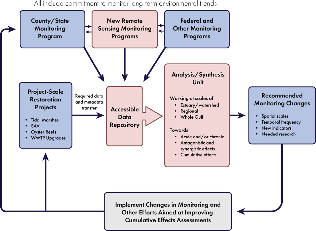
FINAL THOUGHTS
Significant funds have been expended or committed to date on Deepwater Horizon-funded projects. Progress has been made in advancing monitoring and modeling capabilities over the last 10 years (Deepwater Horizon NRDA Trustees 2017a, 2019; NOAA and USGS, 2019), and offer opportunities for further advancement. The emergence of new technologies that enhance monitoring and enable collection and processing of substantially greater amounts of data are occurring across disciplines, but have not yet typically been incorporated into restoration projects. Long-term environmental trends for some parameters and species are now available at local and regional scales, but data collection, analysis, and reporting are often inconsistent and existing efforts are not adequate to potentially detect Gulf-wide trends, and mechanisms to continue these efforts beyond the eventual sunset of Deepwater Horizon restoration programs have not been identified. Application of multiple lines of evidence to assess cumulative effects has been implemented in some long-term science-based management programs initiated prior to the Deepwater Horizon oil spill, but challenges remain in the development of the critical analysis and synthesis of the cumulative effects of Deepwater Horizon projects to date. Assessment of cumulative impacts—additive, synergistic, and possibly antagonistic effects—of multiple restoration projects of similar or diverse nature over spatial and temporal scales beyond that of an individual project is generally lacking. Development of synthesis capacity that can
support an adaptive management process to integrate diverse restoration projects over significant spatial scales is recognized as needed by the Deepwater Horizon funding entities, but has not yet been initiated to a large degree. An underlying theme of this report is the need for integration of science and management of restoration activities. It is envisioned that each Deepwater Horizon funding entity, within its programmatic authority, can work cooperatively with others to realize this integration.
The committee recognizes the challenges faced by the Gulf Coast environmental restoration community, including recovery from the Deepwater Horizon oil spill, as well as the continued impacts of multiple hurricanes and other climatic events, and it applauds the progress made to date on recovery and restoration efforts. The assessment of the largest ecological restoration investment in history is an unprecedented challenge and opportunity. Learning achieved through the remainder of the settlement period will be the foundation for the next generation of managers, who inherit the responsibility for GoM ecosystems and communities. The following report conclusions and recommendations are provided to assist in supporting successful restoration efforts now and in the future.
CONCLUSIONS AND RECOMMENDATIONS
Conclusion 1: Adequate scientific evidence needed to evaluate cumulative effects of restoration on a regional scale in the Gulf of Mexico (GoM) is currently not available and, to date, no entity has been tasked to develop and implement a strategy to assess cumulative effects of environmental restoration efforts. Environmental benefits associated with multiple restoration projects have been observed within some GoM estuaries and watersheds, although not at larger scales. Without a focused effort and strategy, rigorous synthesis of the effects of multiple restoration projects at a regional or Gulf-wide scale cannot be conducted.
Conclusion 2: Because environmental changes can influence the success or failure of restoration efforts and can hinder the ability to detect potential cumulative effects of multiple restoration efforts, a thorough understanding of long-term environmental trends is essential for decision makers and restoration practitioners. Advanced monitoring techniques and approaches, including satellite remote sensing, connected sensor networks, and automation, can greatly assist in determining long-term environmental trends and assessing acute events. In addition, long-term environmental trends derived from targeted monitoring efforts can inform a range of analytical tools. The output from these tools can support the development of adaptive management actions that will subsequently improve restoration success and protect existing investments. Significant spatial and temporal gaps in monitoring GoM-wide environmental indicators and data collection and dissemination efforts limit development of this important and valuable capability. Specifically:
- Long-term environmental trends across the Gulf Coast states are monitored by a patchwork of government agencies, nonprofit organizations, and industries for a variety of reasons (e.g., regulatory, environmental tracking, performance evaluation). Study designs, data collection methods, analyses, and data availability vary and are often not comparable, making synthesis very difficult.
- One-time Gulf-wide monitoring studies are useful, but without periodic updates, do not generate enough information to determine long-term background trends needed for cumulative effects assessments.
- Key metrics to assess landscape-scale changes and support adaptive management include those necessary to estimate environmental trends associated with climate change; freshwater, nutrient, and sediment loading to coastal waters; land use/land cover; ambient water quality; status and trends of finfish and shellfish species, marine mammals, turtles, and birds; and primary and secondary production. For example, enhanced efforts and standardization of methods are needed for:
- ambient water quality, the measurement of which can be enhanced by using high-spatiotemporal-resolution satellite data on chlorophyll a, suspended sediments, colored organic matter, and harmful algae;
-
- tide gage data and subsidence measurements to estimate local, relative sea level rise;
- estimating the extent and effects of ocean and coastal acidification, information essential for successful restoration and maintenance of commercially important shellfish and in the selection of materials for restoration efforts (e.g., oyster shells, limestone);
- tracking, targeting needed research, and managing the effects of tropicalization on fishery species, other species, and habitats; and
- estimating the ecological functioning of restored habitats, something not often measured even though the spatial extent of restored habitats is usually monitored and reported.
Recommendation A: Enhanced, consistent, and sustained long-term monitoring, analysis, synthesis, and reporting of environmental trends and indicators are urgently needed to enable the detection and tracking of cumulative effects of multiple restoration projects. Monitoring efforts should focus on developing the lines of evidence to support the assessment of cumulative effects at estuarine, regional, and larger scales. The Deepwater Horizon funding entities should immediately evaluate methods, identify funding mechanisms, and charge an entity to lead efforts to coordinate and enhance long-term priority monitoring efforts and promote consistent data collection, analysis, synthesis, and reporting among programs; support periodic assessments of collected data; assess the use of advanced techniques; and ensure data availability, with the goal of implementing these changes within 3–5 years.
Conclusion 3: The Gulf Coast environmental restoration community (federal agencies, states, nongovernmental organizations, and local public and private entities) has an opportunity to incorporate what has been learned from past and ongoing ecosystem restoration to inform future projects and programs supported by the remaining Deepwater Horizon funds. However, unless data and information from existing projects are made accessible and identification of information needed to assess cumulative effects of restoration efforts is undertaken more expeditiously, opportunities to improve the likelihood of success in the many projects remaining to be implemented will be greatly reduced or even permanently lost. Although it may be too early to fully assess cumulative effects of Deepwater Horizon-funded restoration efforts because of lag times between implementation and detection of effects, applying “lessons learned” from existing restoration efforts can help mitigate future risks of failure and ensure that Deepwater Horizon funds are invested wisely to increase the likelihood of meaningful and long-term Gulf of Mexico recovery and resilience.
Recommendation B: Restoration funding entities should adopt guidance to ensure that, as soon as they are available, all data, reports, and other project-specific information are deposited into freely accessible repositories that follow FAIR (Findable, Accessible, Interoperable, Reusable) principles. The Deepwater Horizon funding entities should identify and allocate resources to ensure that these data repositories remain functional throughout the life of each program, and additional support (as needed) should be sought to maintain data access in the future.
Recommendation C: The Deepwater Horizon funding entities should expedite the issuance of guidance for adaptive management and cumulative effects assessment at the programmatic scale for Deepwater Horizon-funded large-scale and multiple-restoration efforts. Guidance should include consistency in monitoring criteria that facilitate cumulative effects assessments.
Recommendation D: The Deepwater Horizon funding entities should immediately initiate a synthesis of available information from Deepwater Horizon-funded projects to assess characteristics of successful and unsuccessful restoration efforts. Results should be utilized in designing and implementing effective large-scale restoration projects within geographic areas of concern, and/or adjusting restoration approaches and techniques with the remaining funds from the Deepwater Horizon settlement.
Conclusion 4: Natural and anthropogenic drivers create multiple ecosystem pressures and stressors that act on restoration efforts over broad spatial scales, ranging from individual projects to entire ecosystems. The cumulative impacts of these pressures and stressors are often complex, resulting in synergistic and antagonistic effects of ecological significance. However, synergistic and antagonistic effects of large-scale restoration efforts in the Gulf of Mexico have not been assessed to date, and results from a limited number of assessments are mixed.
Recommendation E: The Deepwater Horizon funding entities should evaluate mechanisms that support cross-state and Gulf-wide collaboration among researchers, resource managers, and practitioners, with an objective to design and implement restoration efforts that allow assessment of antagonistic and synergistic effects.
Conclusion 5: The use of multiple lines of evidence to develop a framework to help assess cumulative effects for large-scale restoration efforts in the Gulf of Mexico has been proposed and, in some cases, applied. Assessment of cumulative effects of large-scale restoration is a recent research area and work on applying this research to restoration implementation is needed.
Conclusion 6: Opportunities exist now to prepare for the assessment of cumulative effects and restoration success from existing regional or large-scale restoration efforts in the Gulf of Mexico. These include:
- applying methods to assess functional equivalency between restored and natural sites;
- assessing the degree of environmental stress from natural and anthropogenic sources;
- applying a multiple-lines-of-evidence approach to assess cumulative effects at the estuary or watershed scale in preparation for Gulf-wide efforts;
- undertaking comparative analysis of estuaries or watersheds across the Gulf of Mexico to develop a greater understanding of similarities and differences among these systems; and
- evaluating expected benefits of a restoration effort as compared to a future condition without the effort.
These opportunities will involve consideration of changing environmental trends and a commitment to monitor, analyze, synthesize, and report results.
Recommendation F: To take advantage of the unprecedented opportunity to assess cumulative effects and inform restoration efforts ongoing and planned in the Gulf of Mexico, the Deepwater Horizon funding entities should evaluate and implement mechanisms necessary to address priority research needs and support efforts assess cumulative effects within the next 3–5 years. Mechanisms could include providing explicit responsibility to and support for existing Gulf-wide entities; development of an independent, regional, multidisciplinary, multiagency team; or a distribution of effort between existing entities.
Recommendation G: As additional monitoring data and scientific evidence become available, Deepwater Horizon program managers should continue to collaboratively develop and implement an adaptive management strategy for the Gulf of Mexico restoration effort, including the development of ecosystem conceptual models. Evaluation of priority issues should use the best available tools and methods, focus on progress of cumulative effects assessments and restoration objectives, and identify necessary changes to restoration approaches if needed. Mechanisms to continue these efforts beyond the eventual sunset of Deepwater Horizon restoration programs should be identified and implemented.
This page intentionally left blank.


