Suggested Citation:"Appendix A: North American Zone Descriptions." National Academies of Sciences, Engineering, and Medicine. 2022. Oil in the Sea IV: Inputs, Fates, and Effects. Washington, DC: The National Academies Press. doi: 10.17226/26410.
×
Appendix A
North American Zone Descriptions
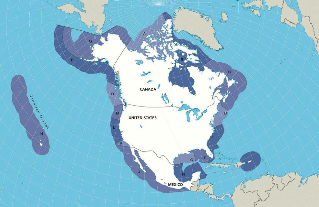
TABLE A.1 Descriptions of Coastal Zones as Defined by This Study
| Zone | Description |
|---|---|
| A | Bounded by a line drawn northerly 0° true along the U.S./Canada border in the Arctic and a line bearing northerly 0° true from Lancaster Island in Canada (includes Arctic Canada west of Hudson Bay). |
| B | Bounded by a line bearing northerly 0° true from Lancaster Island in Canada and a line bearing easterly 90° true from the northern boundary of Newfoundland, Canada (includes Hudson Bay east to the Maritime Provinces in Canada). |
| C | Bounded by a line bearing easterly 90° true from the northern boundary of Newfoundland, Canada, and a line drawn easterly along the U.S./Canada border as follows: a line drawn 90° true from the shore along 44°11′12″ N to 67°16′46″ W; thence southwest to 42°53′14″ N, |
| 67°44′35″ W; thence southeast to 42°31′08″ N, 67°28′05″ W; thence southeast to 40°27′05″ N, 65°41′59″ W. | |
| D | Bounded by a line drawn easterly along the U.S./Canada border and a line bearing due east 90° true from the shore at the Virginia/North Carolina border (35°59.8′ N) to the offshore extent of the EEZ (includes U.S. Coast Guard MSOs Portland, Maine; Boston; Providence; Long Island Sound, Connecticut; New York; Philadelphia; Baltimore; and Hampton Roads, Virginia). |
| E | Bounded by a line bearing due east 90° true from the shore at the Virginia/North Carolina border (35°59.8′ N) to the offshore extent of the EEZ and by a line bearing 227° true drawn from 26°00′ N latitude and 81°30′ W longitude to the offshore extent of the EEZ (includes MSOs Charleston, Savannah, Jacksonville, and Miami). |
| F | Bounded by a line bearing 227° true drawn from 26°00′ N latitude and 81°30′ W longitude to the offshore extent of the EEZ and a line from the Mississippi coast at 89°10′ W bearing southeasterly to 29°10′ N, 88°00′ W; thence southerly bearing 180° true to the offshore extent of the EEZ (includes MSOs Tampa Bay and Mobile). |
| G | Bounded by a line from the Mississippi coast at 89°10′ W bearing southeasterly to 29°10′ N, 88°00′ W; thence southerly bearing 180° true to the offshore extent of the EEZ and a line drawn along the U.S./Mexico border in Texas bearing 90° true to the offshore extent of the EEZ (includes MSOs New Orleans and Morgan City, Louisiana; and Port Arthur, Houston, and Corpus Christi, Texas). |
| H | Includes Mexican offshore waters on the east coast of Mexico that are south of a line bearing 90° true from the U.S./Mexico border to the outermost extent of the EEZ and north of a line bearing 90° true from the Mexico/Belize border to the outermost extent of the EEZ. |
| I | Includes the areas of both the Commonwealth of Puerto Rico and the Territory of the U.S. Virgin Islands to the offshore extent of the EEZ (includes MSO San Juan). |
| J | Includes Mexican offshore waters on the west coast of Mexico that are south of a line bearing 270° true from the U.S./Mexico border to the outermost extent of the EEZ and north of a line bearing 270° true from the Mexico/Guatemala border to the outermost extent of the EEZ. |
| K | Includes a line along the U.S./Mexico border in California to the offshore extent of the EEZ and a line drawn from the intersection of 34°58′ N latitude and the California coastline bearing 229° true to the offshore extent of the EEZ (includes MSOs San Diego and Los Angeles/Long Beach). |
| L | Includes a line drawn from the intersection of 34°58′ N latitude and the California coastline bearing 229° true to the offshore extent of the EEZ and a line drawn along the 42°00′ N latitude from the shore to the offshore extent of the EEZ (includes MSO San Francisco). |
| M | Includes a line drawn along the 42°00′ N latitude from the shore to the offshore extent of the EEZ and a line drawn along the international boundary between the United States and Canada at the entrance to the Strait of Juan de Fuca to the offshore extent of the EEZ (includes MSOs Portland, Oregon; and Puget Sound, Washington). |
| N | Includes Hawaii, American Samoa, Johnston Atoll, Palmyra Atoll and Kingman Reef, Wake Island, Jarvis Island, Howland and Baker Islands, Guam, the Commonwealth of Northern Mariana Islands, and the Trust Territory of the Pacific Islands. |
| O | Includes a line drawn along the international boundary between the United States and Canada at the entrance to the strait of Juan de Fuca to the offshore extent of the EEZ (48°29′38.11″ N, 124°43′34.69″ W to 48°29′38.11″ N, 125°00′00″ to 48°04′00″ N, 126°10′35″ W) and a line along the international boundary bearing 270° true between the United States and Canada at the Dixon entrance to the offshore extent of the EEZ (includes all marine waters in western Canada). |
| P | Includes a line drawn along the international boundary bearing 270° true between the United States and Canada at the Dixon entrance to the offshore extent of the EEZ and a line drawn along the northern edge of the Aleutian Island chain to the offshore extent of the EEZ (includes MSO Southeast Alaska and a portion of MSO Western Alaska). |
| Q | Includes a line drawn along the northern edge of the Aleutian Island chain to the offshore extent of the EEZ and a line drawn northerly 0° true along the U.S./Canada border in the Arctic. |
Suggested Citation:"Appendix A: North American Zone Descriptions." National Academies of Sciences, Engineering, and Medicine. 2022. Oil in the Sea IV: Inputs, Fates, and Effects. Washington, DC: The National Academies Press. doi: 10.17226/26410.
×