
7
Measurement of WUI Fires: Emissions and Exposures
This chapter summarizes the measurements and data needed to improve the understanding of the chemistry of wildland-urban interface (WUI) fires and their emissions. Measurement systems and data are needed on fire detection, characterizing fuels and emissions, and exposure assessment, and to improve model prediction. While existing measurement techniques can provide much of the needed data, improved sampling and chemical analysis systems are needed to capture some of the features of fires at the WUI. The chapter concludes by emphasizing the need for coordination across disciplines to collect robust data that present an integrated picture of the chemistry of WUI fires.
AN OVERVIEW OF DATA AND MEASUREMENT SYSTEMS FOR WUI FIRES
Previous chapters have outlined the diverse data needs associated with understanding the chemistry of fires at the WUI, which range from collecting data on material characteristics of heterogeneous structures, to measuring the concentrations, exposures, and health impacts of large numbers of toxicants, many of which will be present at trace levels. Collecting much of these data is challenging, since the unique chemical signatures of WUI fires are distributed in complex ways in the fire plume.
Data and measurement needs are also interconnected, as shown in Figure 7-1. Data on fuel compositions will determine combustion pathways. The chemical species formed during combustion will determine which atmospheric reaction pathways will be most important. The atmospheric chemistry and transport will determine the toxicants to which communities are exposed and the manner of the exposure. Exposures will determine health impacts. Because of this interconnection, coordinated collection of data and measurements, from fuel and emission characterization to exposures, will have the most value. Collection of data on chemical species over their entire cycle from emission to exposure will enhance the value of all of the data that are collected.
Data and measurements are also needed on various timescales. Retrospective studies of materials, fires, emissions, exposures, and health impacts, both in the field and in laboratories, and via modeling, will be important to improve understanding of the chemistry of WUI fires. These types of studies will benefit from coordinated databases and information repositories that allow efficient sharing of information and methods. Some of the information repositories will also need to be broadly and rapidly accessible. For example, decision-makers charged with mitigating the impacts of WUI fires could utilize information on the types of combustible materials at the WUI to provide first responders and the public with information to mitigate exposure to toxicants.
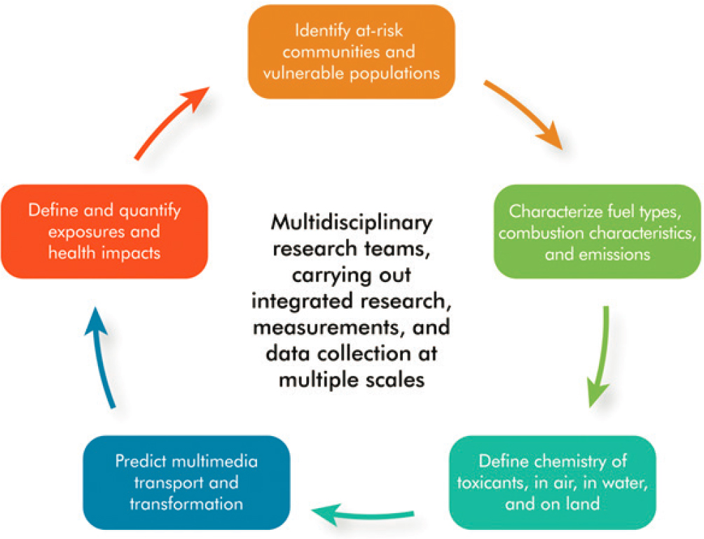
This chapter summarizes the data and measurement needs in each of the steps in the cycle shown in Figure 7-1, from emissions to exposures and impacts. The focus will be on the information needed, the limits of current measurements and data, and prospects for more extensive data collection.
DETECTING AND DETERMINING THE AREAL EXTENT OF WUI FIRES
Several federal agencies are involved in gathering wildfire statistics in the United States, including the National Interagency Fire Center (NIFC). Federal, state, local, and tribal land management agencies report information to the NIFC through established channels using Incident Management Situation Reports. The NIFC’s National Interagency Coordination Center compiles the statistics annually, and they are posted online at https://www.nifc.gov/fire-information/statistics (NIFC, 2022), along with daily news updates and other information. The US Fire Administration, an entity of the US Department of Homeland Security’s Federal Emergency Management Agency, also has a National Fire Incident Reporting System at its National Fire Data Center, which compiles data. While this data collection encompasses both wildland fires and WUI fires, mapping tools, described in Chapter 2, can be used to convert comprehensive fire reporting to reporting specific to WUIs, if broadly accepted definitions of WUIs can be developed.
Wildfires can also be estimated from satellite detection of fire energetics through thermal anomalies (commonly referred to as hot spots). These are pixels with temperature and energy above a threshold value, signifying an active fire. Thermal anomaly data can also be used to measure fire radiative power or fire radiative energy
(the time-integrated fire radiative power) in combination with emission factors specific to ecosystem or land cover type to generate emissions estimates (Wooster et al., 2005). This top-down approach to emissions estimation can provide data in near real time so that it can be used in emergency response as well as in forecasting smoke impacts. However, delays may occur in burn area estimates depending on the data source of the fire radiative power. Fire radiative power can be derived from multiple instruments onboard multiple satellite platforms including the Moderate Resolution Imaging Spectroradiometer (MODIS) on polar orbiting satellites Terra and Aqua, the Visible Infrared Imager Radiometer Suite (VIIRS) on polar orbiting satellite Suomi National Polar-orbiting Partnership, and the Advanced Baseline Imager on geostationary satellites GOES-16 (covering the eastern United States) and GOES-17 (covering the western United States; GOES = Geostationary Operational Environmental Satellite; see Holloway et al. [2021] for more information on satellite data used for fires and air quality). Geostationary satellites can provide continuous data every 15 minutes, while polar orbiting satellites can provide data only during the satellite overpass (Chow et al., 2021). The trade-off with geostationary-derived data is a lower spatial resolution compared to data from polar orbiting satellites (Jaffe et al., 2020).
Combining satellite-derived data with retrospective analysis of burned areas may provide the highest accuracy for estimates of WUI burned areas. For example, the Incident Command System Form 209 reports include information on the fire size and type from ground reports and helicopter perimeters. This information increases the spatial resolution and includes areas missed by satellites during cloud-obstructed times or due to fires not coinciding with the satellite overpass, resulting in a more complete burned-area data set (Larkin et al., 2020).
MEASURING FUELS AND ESTIMATING EMISSIONS
Gathering Data on Fuels for WUI Fires
The fuel loading and consumption for WUI fires are highly heterogeneous and are currently almost always determined through retrospective analysis (e.g., California Department of Forestry and Fire Protection or National Institute of Standards and Technology post-fire damage assessments). For wildfires burning on wildlands, fuel information is typically derived from satellite imagery and augmented by field surveys. Fuel loading data sets derived from satellite imagery are highly uncertain and may not be able to detect the ground fuels obscured by the tree canopy (Kennedy et al., 2020; Peterson et al., 2022). These fuel loading data sets may identify urban areas as unburnable and thus not include any structural or vehicle materials as a “fuel.” Current practice does not estimate WUI fire emissions, and new methodology is needed to estimate emissions from the types of mixed fuels important at the WUI. Satellite data sets on buildings may be one way to develop a bulk structure loading data set comparable to the systems available for mapping wildland fuel loading. However, information on the elemental composition of WUI materials and surveys of the materials in WUI areas are still needed.
Research need: Data sets are needed on the materials loadings and compositions in WUI communities.
Estimating WUI Plume Characteristics and Emissions for Forecasts
Predictive models are important information in providing public health guidance (Chapter 4) and measurements play a critical role in evaluating predictive models; measurement versus model comparisions provide important insights as to what measurements are most critically needed and an assessment as to whether key processes are missing from the models. Ye et al. (2021) recently evaluated the forecasting ability of 12 smoke models for a case study on a single wildland fire. They found that all of the models underpredicted the amount and extent of the plume and that surface concentrations of fine particulate matter (PM2.5) were both overpredicted and underpredicted. These biases were attributed to uncertainties in the emissions and the vertical distribution of the plume. This study provides some insight into where measurement efforts, in coordination with modeling, could be focused to integrate WUI fires into smoke forecasting.
The data required to estimate WUI plume characteristics and emissions draw upon many different data sources of fuels and burned areas and are paired with smoke models to estimate the amount of fuel consumed
and combustion conditions. These smoke models rely on empirical estimates of various parameters, like fuel consumption by phase or plume rise, while other models employ physics-based algorithms to generate estimates (Chow et al., 2021). Computational fluid dynamics models have only recently been developed to include emission chemistry (Josephson et al., 2020) but remain too computationally intensive to be used for large spatial domains and are limited to retrospective analysis. Approaches have independently been developed to estimate emissions from structure and vehicle fires (not in the WUI fire context) using conventional emission inventory methodologies relying on activity data, fuel loadings, and emission factors. The methods used to estimate emissions described by the California Air Resource Board (CARB; Lozo, 1999) and by the SP Technical Research Institute of Sweden (SP; Blomqvist and McNamee, 2009) involve a range of assumptions.
The CARB 1999 method uses constant values for fuel loading, consumption, and emission factors, and determines emissions based on activity data in the form of the number of structures or vehicle fires. The amount of fuel loading is estimated from the average monetary damage claimed in home fires in comparison to the average value of a California residence in 1991. The method assumes an average home size of 1,649 ft2 with 11 tons of lumber, and thus a combustible content of 7.9 lb/ft2. Emission factors for CO, SOx, total organic gas, and particulate matter are taken from emissions measurements from fires of model wood buildings (Butler and Darley, 1972). The NOx emission factor is derived from municipal refuse (EPA, 1995).
The CARB approach can be contrasted with the SP approach (Blomqvist and McNamee, 2009), developed for fires in residences, schools, and vehicles. In the SP method, the structure fuel load is constant while the content loading depends upon the square footage. The SP method uses an assumed constant distribution of material type (e.g., wood, polyvinyl chloride, rubber) for the structure and contents and applies fuel-specific emission factors derived from Research Institutes of Sweden (RISE) emission measurement studies. The SP method also assumes that different amounts of the combustibles are consumed depending on the size of the fire, with 5 percent of the internal materials consumed when the fire is limited to one room, 35 percent of the internal materials and structure consumed when the fire is limited to several rooms, and 80 percent of the internal materials and structure consumed when the fire spreads to other buildings.
Neither of these methods makes any attempt to specify combustion conditions, which can strongly impact emissions, as described in Chapter 3. Chapter 3 also documents that emission factor data sets used in each method have limited chemical information and do not reflect realistic mixtures of urban and wildland fuels or WUI fire conditions. Additionally, these methods do not estimate the heat release rate, which is a critical factor determining plume rise and atmospheric dispersion.
In addition to the retrospective approaches described above, satellite measurements of fire radiative power could detect WUI fires and be included in top-down emission estimates. However, these approaches often use constant emission factors that are applied broadly across land types and therefore would not distinguish between emissions from structures and those from vegetation. As described in Chapter 3, unique emissions from structure fires or vehicles are not captured in current top-down estimates.
Research need: There is a need to update the descriptions of fuel classes to include urban components in areas where WUI fires are common, to develop a methodology for top-down estimates to include the chemistry of burning structures and vehicles in the WUI, and to improve bottom-up emission estimation methodologies for WUI fires.
MEASURING EMISSIONS IN THE FIELD
Measurements of the composition of emissions from fires are made at a variety of spatial and temporal scales. Some of the measurement platforms that have been used in the near vicinity of fires are shown in Figure 7-2. Platforms include vehicles, aircraft, unmanned aerial systems, fixed or mobile ground instruments, instruments mounted on towers, and satellites. The instruments deployed on these platforms vary depending on the power, space, and weight of the instrument hardware, as well as the scientific objectives of the measurement campaign. An example of an advanced instrument package for a large aircraft is provided by the National Center for Atmospheric Research (NCAR-UCAR, 2018). There is a major distinction in the available measurement capabilities between long-term monitoring provided by ambient networks and satellite measurements and monitoring from intensive
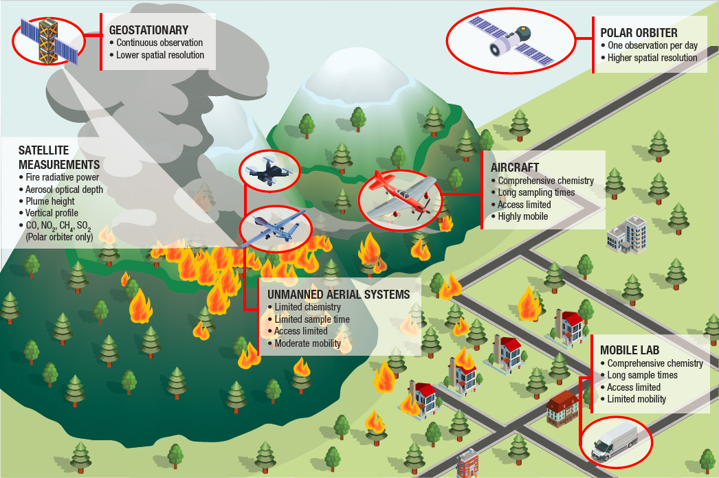
research efforts that may be limited to a few weeks, months, or years during a specific study period. Although brief research studies can provide extremely valuable information, the data must generally be extrapolated across larger geographical and temporal scales outside of the study region and duration.
The measurement platform often determines the spatial and temporal resolution and the compounds that can be measured. For example, geostationary satellites measure continuously but have limited spatial resolution and are currently limited to measures such as fire radiative power and aerosol optical depth. Polar orbiting satellites are able to resolve plume heights, vertical profiles, and concentrations of CO, NO2, CH4, and SO2 (Jaffe et al., 2020). Remotely sensed plume heights or pollutants can be measured by polar orbiting satellites only when the satellite overpass coincides with the fire. As a recent example, the Tropospheric Emissions: Monitoring of Pollution (TEMPO) instrument is anticipated to launch in November 2022 and will have spatial resolution as high as 2.0 × 4.75 km2 and temporal resolution of 10 minutes or less. TEMPO will be able to monitor pollutants that may be important for WUI fires like NO2, SO2, HCHO, CHOCHO, and BrO and to measure aerosol optical depth, absorbing aerosol index, and single-scattering albedo, all of which may be useful for detecting WUI fires apart from other wildland fires (Naeger et al., 2021). TEMPO will have the capability for “near-real-time emission updates to improve air quality forecasts in modeling systems such as the experimental Rapid Refresh with Chemistry (RAP-Chem) model.” Additional future satellite missions like the National Oceanic and Atmospheric Administration’s Geostationary Extended Observations (GeoXO) and GOES-T may also increase the ability to track WUI fire smoke plumes.
Finding: Future satellite platforms will provide high spatial and temporal resolution of some chemical constituents that may be useful for tracking emissions from WUI fires.
Recommendation: WUI fire researchers and smoke forecasters should capitalize on advanced satellite measurements and participate as stakeholders to shape future satellite missions and data products.
Other mobile platforms like aircraft and instrumented vehicles can measure a much wider suite of pollutants, including continuous measurements of particulate matter, volatile organic compounds (VOCs), and inorganic gas (HCl, HF, etc.) concentrations. Unmanned aerial systems are increasingly used to measure fire emissions, but due to payload limitations and battery requirements, they can measure only a few compounds continuously, and they measure most emissions through batch samplers, so that emissions may not all be sampled simultaneously (Aurell et al., 2021).
Finding: Even with large aircraft and advanced instrument platforms, the spatial, temporal, and chemical coverage of fire plumes from any single measurement platform is limited.
To provide more spatial, temporal, and chemical coverage, multiple instrument platforms can be deployed, as shown in Figure 7-2. These coordinated deployments require extensive planning and yet must be deployed quickly to fire locations. The expense and difficulty of these campaigns mean that relatively few fires have been characterized with highly coordinated measurements. Recent examples are the Western Wildfire Experiment for Cloud Chemistry, Aerosol Absorption, and Nitrogen (WE-CAN) and Biomass Burn Observation Project (BBOP), which have largely been limited to aircraft measurements in smoke plumes. Some campaigns have focused on prescribed burns to allow for more-detailed advanced planning and a much larger range of data collected, particularly on the fuel composition, consumption, and fire behavior. Examples are the Prescribed Fire Combustion-Atmospheric Dynamics Experiments (Rx-CADRE) and the Fire and Smoke Model and Evaluation Experiment (FASMEE); however, these types of measurements are necessarily restricted to wildland fires. Fire Influence on Regional to Global Environments and Air Quality (FIREX-AQ) is an example of a multi-platform interdisciplinary approach to investigating wildfire smoke that may be a model for future efforts for measuring smoke from WUI fires. However, any future campaigns may require an extended commitment to ensure readiness not just during the traditional fire season (since WUI fires can occur at any time in the year), but also through multiple years to allow for the episodic nature of WUI fires.
Making measurements of the portions of fire plumes that come from the WUI becomes even more challenging. Many WUI fires occur during a very short time frame, often within the span of 24 hours, and the response during that time focuses on preventing loss of life and on defensive actions to protect structures. This rapid evolution of the fire reduces opportunities to capture air emissions from active phases of the fire. However, post-fire assessments are more feasible for measuring emissions from residual smoldering and the composition of deposited ash, residues, soil, and water samples. The National Institute of Standards and Technology has developed methods for collecting data in the field that are integrated into the Incident Command System, including pre-fire training with local partners, which enables rapid (<48 hour) approval of research studies and deployment of study teams into WUI areas (Maranghides et al., 2011).
Finding: WUI fires evolve rapidly, and emergency response activities may limit the ability to deploy and measure emissions from the active phases of the fire.
While field measurement campaigns characterizing wildland fires and WUI fires have limitations, they remain an essential tool for advancing the scientific understanding of wildland and WUI fires. Significant expansion of the data sets on WUI fires will require both continued commitment to existing measurement platforms, and identifying mechanisms for more deployment of instrumentation operating at multiple scales.
Research need: There is a need to develop planned research activities that can be integrated into the Incident Command System before an emergency event to facilitate rapid deployment of the measurement of emissions, residues, and environmental impacts from WUI fires.
Because of the limitations of field measurements of emissions from wildland and WUI fires, and because of the wide variety of fire conditions and fuels that may lead to emissions, laboratory investigations of wildland fire emissions, urban fire emissions, and mixed wildland and urban fire emissions play a critical role in understanding the chemistry of these fires. These research needs are described in Chapter 3.
MONITORING EMISSIONS USING CONTINUOUS/AMBIENT NETWORKS
Over larger spatial and longer temporal scales, fixed monitoring networks, which have been deployed for other purposes, can provide information about the large-scale dispersion of fire plumes. For example, a large number of continuous air quality monitoring stations (CAMSs) are operated throughout the United States by the federal, state, and local governments to assess compliance with National Ambient Air Quality Standards (NAAQS). Because these CAMSs are aimed at assessing NAAQS compliance, they are concentrated in urban areas, and measurements focus on criteria air pollutants such as ozone, particulate matter, and their precursors (e.g., oxides of nitrogen and VOCs), often on an hourly basis (Scheffe et al., 2009). Despite this limited chemical scope, these networks provide important information about the extent of exposure to fire plumes. A limited number of these CAMSs have specific routine measurements aimed at identifying the contributions of biomass burning to measured concentrations. For example, the State of Texas deploys instruments to measure the brown carbon component of particulate matter at multiple CAMS sites to assess contributions of biomass burning (Guagenti et al., 2019; Sheesley et al., 2019).
In addition to CAMS sites, several other ambient monitoring networks measure a larger range of chemical compounds and may be better equipped to detect the potentially unique chemical nature of a WUI fire plume. The national networks have widely available data for a limited number of locations, but many states and local agencies maintain other environmental monitoring networks that measure a variety of chemical species in different environmental matrices (air, water, and soil samples), with varying spatial and temporal coverage. Data from state and local measurements may not be available publicly but can often be obtained by request.
The national networks often operate on a sampling schedule, limiting their ability to capture transient WUI fire plumes. Most air monitoring networks sample for one 24-hour period on a multiday schedule (e.g., 1 day every 3 days, called 1-in-3). The critical review by Hidy et al. (2017) provides a description of air quality monitoring networks, the compounds they measure, and network design and operation in more detail. Table 7-1 lists some of these national air monitoring networks and their details. These types of platforms could be used to expand sampling capabilities for fires, taking advantage of the power, communication, and other infrastructure available at these sites. The opportunities for expanded sampling could also be extended to include national networks for other environmental media, and state and local networks.
Much of the continuous measurement data from national networks is available in near real time and assembled in databases by the US Environmental Protection Agency (EPA). Measurements that require extensive chemical analysis are available several months to a year after the sample was originally taken. These measurements follow
TABLE 7-1 Nationally Supported Ambient Air Monitoring Networks
| Monitoring Network | Target Species | Siting Environment | Approximate Number of Sites | Sampling Schedule | Purpose |
|---|---|---|---|---|---|
| National Air Toxic Trends Station (EPA, 2021a) | Hazardous air pollutants (VOCs, carbonyls, metals, polycyclic aromatic hydrocarbons [PAHs]) | Mostly urban, limited rural | 26 | 1-in-6 or 1-in-12 | Regulatory effectiveness |
| Chemical Speciation Network (EPA, 2021b) | PM2.5 mass and chemical composition | Urban | 150 | 1-in-3 or 1-in-6 | Long-term air quality trends |
| Interagency Monitoring of Protected Visual Environments (IMPROVE) (IMPROVE, 2022) | PM2.5 and coarse particulate matter (PM10) chemical composition | Rural | 110 | 1-in-3 | Long-term visibility trends |
| National Core Monitoring Network (EPA, 2016) | PM2.5 mass and chemical composition, O3, CO, SO2, reactive nitrogen | Urban and rural | 78 | 1-in-3 | Scientific research |
| Clean Air Status and Trends Network (EPA, 2021c) | PM2.5 mass, ammonia, acidic gases, ions | Rural | 100 | 1-in-7 | Long-term acid deposition trends |
| Atmospheric Science and Chemistry Measurement Network (GATech, 2021) | PM2.5 chemical composition and size distribution | Urban and rural | 12 | Continuous | Scientific research |
established EPA methods and quality assurance procedures that ensure the validity of the data. EPA maintains standard measurement methods for a large number of chemical compounds in different environmental matrices (e.g., Compendium of Methods for the Determination of Toxic Organic Compounds in Air) that may need readily applied or adapted WUI fire measurements.
Ambient monitoring networks provide insights into ambient concentrations associated with total fire plumes but are generally not able to distinguish the contributions from fires at the WUI. However, they provide valuable data that can be used to evaluate the performance of air quality models or for studies that examine the sources of emissions and the amount from each source, to constrain estimates of emissions from WUI fires.
Multiple limitations to the current monitoring networks impede the characterization of WUI fire plumes. Most important are the limited spatial and temporal coverage of detailed chemical speciation measurements. Most monitoring sites are in urban areas distant from wildlands that may be less likely to be impacted by a WUI fire plume. Additionally, these networks were designed to monitor long-term trends, and the scheduled sampling time may not coincide with when a plume impacts the site. Samplers may lose power due to the fire or become overloaded due to high concentrations.
Finding: Some ambient monitoring networks measure an extensive range of hazardous air pollutants that may be useful to identify the environmental impacts of WUI fires; however, these networks have limited spatial and temporal resolution.
In addition to the permanent monitoring programs described above, US states and the US Forest Service operate temporary monitoring programs through the Interagency Wildland Fire Air Quality Response Program (USFS, 2021). These deployments target areas where smoke impacts are anticipated and where few or no monitoring stations exist. After the 2018 Camp Fire, the California Air Resources Board identified the need for portable samplers for particulate matter and hazardous air pollutants for specific wildfire events in addition to increasing the sampling frequency and duration in monitoring networks (CARB, 2021).
Research need: Identify possible expansions of the capabilities of national, regional, and local monitoring networks that would enhance information regarding fire emissions and exposures. Evaluate the capabilities and information that could be provided by permanently deployed equipment and equipment that might be portable and deployed on an as-needed basis.
ASSESSING EXPOSURE
As discussed in Chapter 6, exposure is contact with a substance (e.g., WUI fire emissions) via inhalation, ingestion, or touching of the skin. Therefore, emissions data and ambient environment monitoring data to estimate exposures need to be supplemented with the spatial and temporal patterns of human contact to estimate human exposure. Exposure measurement represents individual experience and can capture the intra- and inter-individual variability of impacts within a population. This more accurate representation can be especially important in the case of the dynamic emissions and transport in WUI fires. Thus, exposure measurement is applicable for constructing exposure-response relationships, determining thresholds for exposure controls, and assessing the effectiveness of interventions to reduce exposures.
Exposure is often represented as the concentration of the substance in the relevant environmental matrix/matrices at the location(s) where contact is being made, and its quantification may also take into account the frequency and duration of contact (EPA, 2021d). Measurements of human exposures to environmental contaminants including WUI fire emissions can be conducted through area, personal, and biological monitoring.
Area monitoring for airborne contaminants involves the sampling of air with monitoring equipment at specific indoor or outdoor locations. This is analogous to the collection of samples of water or soil with which persons may interact. Such monitoring discounts the possibility that individuals may interact with multiple microenvironments with varying fire emission concentrations during and after WUI fires.
Personal monitoring eliminates this limitation because of the placement or direct application of the monitoring equipment on the individual. While this approach has been used for firefighters at wildland and structural fires,
the unplanned and chaotic nature of fires almost entirely precludes its use for the general population. It can also be impractical due to the cost of implementation for a large population and the intrusiveness that may accompany the wearing of monitoring equipment that may be bulky and/or noisy. However, personal monitoring of first responders such as firefighters is a reasonable option that should be considered.
Rather than the external concentration that is measured with area and personal monitoring, biological monitoring (biomonitoring) involves the measurement of biomarkers, which are substances (e.g., fire emissions or their metabolites) in biological fluid or tissue that are indicative of exposure. While they may more accurately represent internal exposure, biomarkers (e.g., urinary hydroxylated PAHs) that have been used to assess exposures to wildland and structural fires are nonspecific and may be due to exposures from other sources. They also do not discriminate between exposure routes (inhalation, ingestion, or dermal absorption) and are subject to inter-individual variability in their biokinetic behavior.
Regardless of whether area, personal, or biological exposure monitoring is employed, exposure measurement involves sampling the matrix containing the analyte used for quantifying exposure and its instrumental analysis. Methods of sampling for WUI fire emissions are summarized below.
Air Sampling
Generally, sampling for airborne contaminants including WUI fire emissions can be achieved (1) passively by relying on diffusive air flow through a medium that is used to abstract the contaminant from the airstream or (2) actively by pumping air at a specified flow rate through the medium. Published methods for known WUI fire emissions require active sampling, with an exception being the National Institute for Occupational Safety and Health (NIOSH) Method 6700 for NO2.
The medium used for sampling depends on the physical and chemical characteristics of the contaminant. Particulates including fine particles, asbestos, and metals are sampled for analysis using filters of various membrane materials (e.g., Teflon and polyvinyl chloride). Gas-phase contaminants, including ammonia, inorganic acid and asphyxiant gases, ozone, and VOCs, are sampled by adsorption to (e.g., NIOSH Method 1501 for aromatic hydrocarbons including benzene) or reaction with (e.g., Occupational Safety and Health Administration [OSHA] Method ID-214 for ozone) a solid material, or by reaction in a solvent contained in an impinger (e.g., NIOSH Method 3500 for formaldehyde). Semi-VOCs are sampled using a combination of filters and sorbent material (e.g., NIOSH Method 5515 for PAHs). Whole air samples can also be actively sampled into containers including evacuated canisters and sampling bags (e.g., NIOSH Method 3900 for VOCs).
Although area and personal air monitoring data might represent more accurate exposure information, it is difficult to put resources in place to collect such data for the unplanned, relatively short and episodic air pollution that is caused by WUI fires. Therefore, such data are not typically available.
Soil, Water, and Surface Sampling
Soil, ash, and water for instrumental analysis of WUI fire emissions can be collected from an area/environment that is accessible to individuals by discrete or composite sampling of bulk material into appropriate, precleaned containers. Equipment used to retrieve such samples includes the trowel and auger for soil, brush and spoon for ash, hand-held and weighted bottles for surface water, and bailers and bladder pumps for groundwater. Some automation may be involved in some of the soil and water sampling procedures.
Settled dust on smooth, nonporous surfaces can be sampled for WUI fire emissions using wipes made from various materials including polyester, polypropylene, polyvinyl alcohol, and polyester plus cellulose (OSHA, 2001). The wipes are prewetted, for example, with water for sampling metals (e.g., OSHA Method ID-206) or with organic solvents for sampling organics (e.g., American Society for Testing and Materials [ASTM] Standard Practice D6661-17 [ASTM, 2017]). As an example, Hwang et al. (2019) used Alpha Wipes prewetted with isopropyl alcohol for sampling various surfaces in fire vehicles of structural firefighters for PAHs (Hwang et al., 2019).
Vacuuming can be used to sample settled dust from the floor and porous surfaces (e.g., ASTM Method D5438). Micro-vacuuming settled dust onto a filter membrane cassette is an alternative approach and is especially applied for sampling for non-airborne, settled asbestos (ASTM Method 5755). However, soil, water, and surface
monitoring data often indicate potential exposure and may not accurately represent actual exposure. While the lack of baseline measurements can hamper the applicability of soil, water, and surface monitoring for exposure assessment (Murphy et al., 2020), post-fire longitudinal monitoring can inform studies about changes in potential exposure to WUI fire–mediated pollution, as demonstrated in a study of the watersheds impacted by the Horse River Fire (Emmerton et al., 2020).
Sampling for Dermal Absorption
Sampling of clothing and the skin with the same wipe materials and wetting agents that are used for surface sampling can be used for dermal exposure assessment. Corn oil has also been used as a wetting agent (Fent et al., 2014, 2017). Skin and/or cloth wipes have been used to sample for PAHs among structural and wildland firefighters (Banks et al., 2021; Cherry et al., 2021; Fent et al., 2014, 2017) and dioxins, furans, and flame retardants among structural firefighters (Fent et al., 2020). Passive sampling by the placement of an adsorbent, silicone-based wristband or dog tag placed under firefighting clothing (Baum et al., 2020; Caban-Martinez et al., 2020; Poutasse et al., 2020), and tape stripping of the skin, have also been used to assess PAH exposure among structural firefighters (Sjostrom et al., 2019; Strandberg et al., 2018). However, the need to compare with a baseline, to adequately determine exposure, limits the applicability of these dermal sampling approaches to unplanned wildland and WUI fire events. Furthermore, standardized methodology and dermal exposure standards are lacking.
Biological Sampling
Blood, exhaled breath, and urine have been used for the biomonitoring of structural and wildland firefighters in many recent studies (Adetona et al., 2017; Ekpe et al., 2021; Fent et al., 2014, 2019; Mayer et al., 2021; Shaw et al., 2013). Urine and exhaled breath are the preferred biological fluids for short-lived and readily excretable biomarkers that are used for biomonitoring acute exposures such as PAHs and benzene (Adetona et al., 2017; Fent et al., 2014, 2019). Such monitoring often needs a baseline comparison and timely collection of samples. Long-lived and/or lipophilic biomarkers that reflect cumulative chronic exposures such as polychlorinated biphenyls, brominated flame retardants, perfluoroalkyl substances, dioxins, and furans are typically measured in the blood (Ekpe et al., 2021; Park et al., 2015; Shaw et al., 2013). Since these biomarkers are nonspecific, their use for the biomonitoring of exposure to WUI fire smoke may be confounded by other sources of exposure. However, this limitation can partially be addressed by collecting and comparing pre- and post-exposure samples. Biomonitoring also can afford the opportunity to be efficient in the evaluation of exposures and toxic effects in the same biological fluid.
Instantaneous Monitoring by Direct Reading Instruments
Direct reading (instantaneous monitoring) instruments that sample, perform instrumental analysis, and read out almost instantaneously are available for various WUI fire emissions. Examples include single- or multiple-sensor monitors that are used for many inorganic gases, and the electrochemical sensor that is the specified technique in NIOSH Method 6604 for CO monitoring (Wu et al., 2021). Other examples include a nondispersive infrared monitor for CO2 monitoring, portable gas chromatograph/photoionization detector analyzer for VOC measurement, X-ray fluorescence analyzer for in situ measurement of metals in soil, and real-time meters that are used to measure general water quality parameters such as turbidity, total dissolved solids, and dissolved oxygen.
Many of these instruments can be used for both area and personal monitoring since they are portable. Continuous or integrated monitoring can also be conducted with instantaneous monitoring instruments that are equipped with data loggers. CO from exhaled breath, a biomarker, has also been measured among wildland firefighters using direct reading monitors (Dunn et al., 2009; Miranda et al., 2012). However, many of these instruments are susceptible to interferences, may not be accurate, and have relatively low sensitivity and high limits of detection (Spinelle et al., 2017).
Exposure Modeling
Modeling can potentially be used to improve exposure estimates that are obtained from area and personal monitoring. Statistical models such as land use regression, geographically weighted regression, and random forest have been used to estimate PM2.5 concentration across space based on measurements from stationary regulatory ambient air monitoring stations, including during a WUI fire (Gan et al., 2017; Mirzaei et al., 2018; Vu et al., 2022). Such modeling allows for the spatiotemporal variability in concentrations to be better captured and has been used in the assessment of exposure-response relationships related to wildfire-impacted air quality (Gan et al., 2017). These models can include meteorology and land use variables, population density, and satellite-based pollution data as independent variables, with ground-level measurements as the dependent variable.
These models can be adapted for use with area monitoring, as has been demonstrated using data from the crowdsourced network of low-cost direct reading PM2.5 PurpleAir sensors (Lu et al., 2022). Moreover, model predictions were improved when the ambient regulatory data and the crowdsourced, area-monitoring data were both used in the models (Lu et al., 2022; Vu et al., 2022).
Even so, measurements based on personal and enhanced area monitoring still have limitations and do not incorporate exposure factors that are important causes of variability in exposure. As previously noted, area monitoring assumes a similar frequency and duration of exposure across different microenvironments, and both approaches do not incorporate factors that determine the uptake of contaminants, such as inhalation rate and gas absorption, or particle deposition rates for inhalation exposures. When appropriate, the integration of these factors with monitoring data will result in more accurate estimations of exposure, improved definition of susceptible and vulnerable populations, more refined strategies for exposure control, and better testing of these strategies’ effectiveness.
Research need: There is a need to identify new biomarkers that are more specific for WUI fires and can be used for exposure and toxicity assessment.
SAMPLING AND ANALYTICAL METHODS
From fuels and emissions to exposures, measurement approaches and data rely on advanced analytical techniques. Despite recent advances in analytical chemistry, little progress has been made in the determination and analysis of fire emissions. The major limitations are near-field access to fires and the complexity involved in sampling and measuring fire emissions (Stec, 2017).
The choice of sampling method and analytical method to characterize airborne contaminants at a fire incident depends on the physical nature of the airborne samples (i.e., vapor and/or aerosol), the estimated concentrations of contaminants, and any potential interactions with or interferences from other contaminants. Characterization of the fire environment is therefore based on the identification of which of these predefined compounds is considered to be the most significant or major component of the smoke. The choice of specific chemicals to monitor is also based on the availability of methods that reliably collect and analyze air-contaminant samples in the fire environment. Therefore, sampling and analysis focus on relatively simple analytes (or groups of analytes) of concern.
Over the last few years, the use of low-cost screening devices and sensors has increased. The most common are optical particle counters for measuring the size distribution of particles (particulate matter, such as PM1, PM2.5, and PM10), electrochemical sensors (for CO, O3, NO, HCl, HBr, NO2, SO2, H2S, VOCs, etc.), photoionization detectors, and infrared spectral photometers. While most of these sensors are portable and user friendly, several limitations need to be considered. These include cross-sensitivity, interference from environmental effects (wind, rain, etc.), baseline drift, linearity, and dynamic range. Selectivity of the analytical method (i.e., avoiding matrix effects and/or interference from other fire species), sensitivity, limits of detection, and quantification, to name a few major issues, also need to be carefully considered when selecting from the large number of analytical methodologies.
Research need: There is a need to develop new analytical capabilities for measuring a wide variety of chemical, particle, and biological indicators of toxicants in emission, exposure, and health effects studies.
Research need: There is a need to optimize analytical methods for field deployment and increased accessibility.
COORDINATING MEASUREMENTS OF WUI FIRES
Some types of data discussed in this chapter characterize the fires and the fuels that are combusted. Other types of data are direct field measurements of WUI fire emissions at a variety of spatial scales. These field measurements complement data from controlled laboratory experiments where fuel and fire conditions can be systematically examined and where a greater variety of chemical measurements can be deployed than are available for field studies. Data on the fate, transport, and transformation of emissions need to be coupled with data that characterize human exposure, including personal exposure measurements and biomonitoring. Because each of these data elements informs other elements, data collected in a coordinated way are most valuable.
REFERENCES
Adetona, O., C. D. Simpson, Z. Li, A. Sjodin, A. M. Calafat, and L. P. Naeher. 2017. “Hydroxylated Polycyclic Aromatic Hydrocarbons as Biomarkers of Exposure to Wood Smoke in Wildland Firefighters.” Journal of Exposure Science and Environmental Epidemiology 27 (1): 78–83. https://doi.org/10.1038/jes.2015.75.
ASTM (American Society for Testing and Materials). 2017. Standard Practice for Field Collection of Organic Compounds from Surfaces Using Wipe Sampling. ASTM D6661-17.
Aurell, J., B. Gullett, and A. Holder. 2021. “Wildland Fire Emission Sampling at Fishlake National Forest, Utah Using an Unmanned Aircraft System.” Atmospheric Environment. https://doi.org/10.1016/j.atmosenv.2021.118193.
Banks, A. P. W., P. Thai, M. Engelsman, X. Wang, A. F. Osorio, and J. F. Mueller. 2021. “Characterising the Exposure of Australian Firefighters to Polycyclic Aromatic Hydrocarbons Generated in Simulated Compartment Fires.” International Journal of Hygiene and Environmental Health 231. https://doi.org/10.1016/j.ijheh.2020.113637.
Baum, J. L. R., U. Bakali, and C. Killawala. 2020. “Evaluation of Silicone-Based Wristbands as Passive Sampling Systems Using PAHs as an Exposure Proxy for Carcinogen Monitoring in Firefighters: Evidence from the Firefighter Cancer Initiative.” Ecotoxicology and Environmental Safety 205. https://doi.org/10.1016/j.ecoenv.2020.111100.
Blomqvist, P., and M. McNamee. 2009. Estimation of CO2-Emissions from Fires in Dwellings, Schools and Cars in the Nordic Countries. SP Technical Note 2009:13. Borås, Sweden: SP Swedish National Testing and Research Institute. https://www.diva-portal.org/smash/get/diva2:961412/FULLTEXT01.pdf.
Butler, C. P., and E. F. Darley. 1972. “Fire Dynamics of Model Wood Buildings Fire and Flammability.” Journal of Fire and Flammability 3: 330–339.
Caban-Martinez, A., P. Louzado-Feliciano, and K. M. Santiago. 2020. “Objective Measurement of Carcinogens among Dominican Republic Firefighters Using Silicone-Based Wristbands.” Journal of Occupational and Environmental Medicine 62. https://doi.org/10.1097/JOM.0000000000002006.
CARB (California Air Resources Board). 2021. Camp Fire Air Quality Data Analysis. Sacramento, CA: California Air Resources Board. https://ww2.arb.ca.gov/resources/documents/camp-fire-air-quality-data-analysis.
Cherry, N., J. M. Galarneau, D. Kinniburgh, B. Quemerais, S. Tiu, and X. Zhang. 2021. “Exposure and Absorption of PAHs in Wildland Firefighters: A Field Study with Pilot Interventions.” Annals of Work Exposures and Health 65 (2): 148–161. https://doi.org/10.1093/annweh/wxaa064.
Chow, F. K., K. A. Yu, and A. Young. 2021. “High-Resolution Smoke Forecasting for the 2018 Camp Fire in California.” Bulletin of the American Meteorological Society. https://doi.org/10.1175/BAMS-D-20-0329.1.
Dunn, K. H., I. Devaux, and A. Stock. 2009. “Application of End-Exhaled Breath Monitoring to Assess Carbon Monoxide Exposures of Wildland Firefighters at Prescribed Burns.” Inhalation Toxicology 21 (1). https://doi.org/10.1080/08958370802207300.
Ekpe, O. D., W. Sim, and S. Choi. 2021. “Assessment of Exposure of Korean Firefighters to Polybrominated Diphenyl Ethers and Polycyclic Aromatic Hydrocarbons via Their Measurement in Serum and Polycyclic Aromatic Hydrocarbon Metabolites in Urine.” Environmental Science & Technology 55 (20): 14015–14025. https://doi.org/10.1021/acs.est.1c02554.
Emmerton, C. A., C. A. Cooke, S. Hustins, U. Silins, M. B. Emelko, T. Lewis, M. K. Kruk, N. Taube, D. Zhu, B. Jackson, M. Stone, J. G. Kerr, and J. F. Orwin. 2020. “Severe Western Canadian Wildfire Affects Water Quality Even at Large Basin Scales.” Water Research 183. https://doi.org/10.1016/j.watres.2020.116071.
EPA (US Environmental Protection Agency). 1995. Compilation of Air Emissions Factors. https://www.epa.gov/air-emissions-factors-and-quantification/ap-42-compilation-air-emissions-factors.
EPA. 2016. NCore Multipollutant Monitoring Network. https://www3.epa.gov/ttn/amtic/ncore.html.
EPA. 2021a. Air Toxics Ambient Monitoring. https://www.epa.gov/amtic/air-toxics-ambient-monitoring.
EPA. 2021b. Chemical Speciation Network (CSN). https://www.epa.gov/amtic/chemical-speciation-network-csn.
EPA. 2021c. Clean Air Status and Trends Network (CASTNET). https://www.epa.gov/castnet.
EPA. 2021d. Exposure Assessment Tools by Approaches. https://www.epa.gov/expobox/exposure-assessment-tools-approaches.
Fent, K. W., J. Eisenberg, J. Snawder, D. Sammons, J. D. Pleil, M. A. Stiegel, C. Mueller, G. P. Horn, and J. Dalton. 2014. “Systemic Exposure to PAHs and Benzene in Firefighters Suppressing Controlled Structure Fires.” Annals of Occupational Hygiene 58 (7): 830–845. https://doi.org/10.1093/annhyg/meu036.
Fent, K. W., B. Alexander, J. Roberts, S. Robertson, C. Toennis, D. Sammons, S. Bertke, S. Kerber, D. Smith, and G. Horn. 2017. “Contamination of Firefighter Personal Protective Equipment and Skin and the Effectiveness of Decontamination Procedures.” Journal of Occupational and Environmental Hygiene 14 (10): 801–814. https://doi.org/10.1080/15459624.2017.1334904.
Fent, K. W., C. Toennis, D. Sammons, S. Robertson, S. Bertke, A. M. Calafat, J. D. Pleil, M. A. Geer Wallace, S. Kerber, D. L. Smith, and G. P. Horn. 2019. “Firefighters’ and Instructors’ Absorption of PAHs and Benzene during Training Exercises.” International Journal of Hygiene and Environmental Health 222 (7): 991–1000. https://doi.org/10.1016/j.ijheh.2019.06.006.
Fent, K. W., M. LaGuardia, D. Luellen, S. McCormick, A. Mayer, I. Chen, S. Kerber, D. Smith, and G. P. Horn. 2020. “Flame Retardants, Dioxins, and Furans in Air and on Firefighters’ Protective Ensembles during Controlled Residential Firefighting.” Environment International 140. https://doi.org/10.1016/j.envint.2020.105756.
Gan, R. W., B. Ford, W. Lassman, G. Pfister, A. Vaidyanathan, E. Fischer, J. Volckens, J. R. Pierce, and S. Magzamen. 2017. “Comparison of Wildfire Smoke Estimation Methods and Associations with Cardiopulmonary-Related Hospital Admissions.” GeoHealth 1 (3): 122–136. https://doi.org/10.1002/2017GH000073.
Guagenti, M., Shrestha, S., Flynn, J., Alvarez, S. L., Sheesley, R. J., and Usenko, S. December 2019. “Utilizing Intensive Aerosol Optical Properties for The Detection of Biomass Burning in El Paso, Texas-(BC)2 El Paso Field Campaign.” In American Geophysical Union, Fall Meeting 2019 abstract #A23L–2967.
GATech (Georgia Institute of Technology). 2021. “$12 Million NSF Grant Will Establish Nationwide Atmospheric Measurement Network.” https://research.gatech.edu/12-million-nsf-grant-will-establish-nationwide-atmospheric-measurement-network.
Hidy, G. M., P. K. Mueller, S. L. Altshuler, and J. C. Chow. 2017. “Air Quality Measurements—From Rubber Bands to Tapping the Rainbow. Journal of the Air & Waste Management Association 67 (6). https://doi.org/10.1080/10962247.2017.1308890.
Holloway, T., D. Miller, S. Anenberg, M. Diao, B. Duncan, A. M. Fiore, D. K. Henze, J. Hess, P. L. Kinney, Y. Liu, J. L. Neu, S. M. O’Neill, M. T. Odman, R. B. Pierce, A. G. Russell, D. Tong, J. J. West, and M. A. Zondlo. 2021. “Satellite Monitoring for Air Quality and Health.” Annual Review of Biomedical Data Science 4 (1): 417–447. https://doi.org/10.1146/annurev-biodatasci-110920-093120.
Hwang, J., R. Taylor, and C. Cann. 2019. “Evaluation of Accumulated Polycyclic Aromatic Hydrocarbons and Asbestiform Fibers on Firefighter Vehicles: Pilot Study.” Fire Technology 55. https://doi.org/10.1007/s10694-019-00851-7.
IMPROVE (Interagency Monitoring of Protected Visual Environments). 2022. “Interagency Monitoring of Protected Visual Environments.” http://vista.cira.colostate.edu/Improve/.
Jaffe, D. A., S. M. O’Neill, N. K. Larkin, A. L. Holder, D. L. Peterson, J. E. Halofsky, and A. G. Rappold. 2020. “Wildfire and Prescribed Burning Impacts on Air Quality in the United States.” Journal of the Air & Waste Management Association 70 (6): 583–615. https://doi.org/10.1080/10962247.2020.1749731.
Josephson, A. J., D. Castano, and E. Koo. 2020. “Zonal-Based Emission Source Term Model for Predicting Particulate Emission Factors in Wildfire Simulations.” Fire Technology 57. https://doi.org/10.1007/s10694-020-01024-7.
Kennedy, M. C., S. J. Prichard, and D. McKenzie. 2020. “Quantifying How Sources of Uncertainty in Combustible Biomass Propagate to Prediction of Wildland Fire Emissions.” International Journal of Wildland Fire 29. https://doi.org/10.1071/WF19160.
Larkin, N. K., S. M. Raffuse, and S. Huang. 2020. “The Comprehensive Fire Information Reconciled Emissions (CFIRE) Inventory: Wildland Fire Emissions Developed for the 2011 and 2014 U.S. National Emissions Inventory.” Journal of the Air & Waste Management Association 70 (11). https://doi.org/10.1080/10962247.2020.1802365.
Lozo, C. 1999. Structure and Automobile Fires. https://www.arb.ca.gov/ei/areasrc/fullpdf/full7-14.pdf.
Lu, T., M. J. Bechle, and Y. Wan. 2022. “Using Crowd-Sourced Low-Cost Sensors in a Land Use Regression of PM2.5 in 6 US Cities.” Air Quality, Atmosphere & Health 15: 667–678. https://doi.org/10.1007/s11869-022-01162-7.
Maranghides, A., W. Mell, K. Ridenour, and D. McNamara. 2011. Initial Reconnaissance of the 2011 Wildland-Urban Interface Fires in Amarillo, Texas. Gaithersburg, MD: National Institute of Standards and Technology.
Mayer, A. C., K. W. Fent, and I. Chen. 2021. “Characterizing Exposures to Flame Retardants, Dioxins, and Furans among Firefighters Responding to Controlled Residential Fires.” International Journal of Hygiene and Environmental Health 236. https://doi.org/10.1016/j.ijheh.2021.113782.
Miranda, A. I., V. Martins, and P. Cascao. 2012. “Wildland Smoke Exposure Values and Exhaled Breath Indicators in Firefighters.” Journal of Toxicology and Environmental Health, Part A 75. https://doi.org/10.1080/15287394.2012.690686.
Mirzaei, M., S. Bertazzon, and I. Couloigner. 2018. “Modeling Wildfire Smoke Pollution by Integrating Land Use Regression and Remote Sensing Data: Regional Multi-Temporal Estimates for Public Health and Exposure Models.” Atmosphere 9 (9). https://doi.org/10.3390/atmos9090335.
Murphy, S. F., R. B. McCleskey, D. A. Martin, J. M. Holloway, and J. H. Writer. 2020. “Wildfire-Driven Changes in Hydrology Mobilize Arsenic and Metals from Legacy Mine Waste.” Science of the Total Environment 743: 140635. https://doi.org/10.1016/j.scitotenv.2020.140635.
Naeger, A. R., M. J. Newchurch, T. Moore, K. Chance, X. Liu, S. Alexander, K. Murphy, and B. Wang. 2021. “Revolutionary Air-Pollution Applications from Future Tropospheric Emissions: Monitoring of Pollution (TEMPO) Observations.” Bulletin of the American Meteorological Society 102 (9): E1735–E1741. https://journals.ametsoc.org/view/journals/bams/102/9/BAMS-D-21-0050.1.xml (accessed July 16, 2022).
NCAR-UCAR (National Center for Atmospheric Research–University Corporation for Atmospheric Research). 2018. WE-CAN Instrumentation Payload. https://www.eol.ucar.edu/content/we-can-instrumentation-payload.
NIFC (National Interagency Fire Center). 2022. Fire Information: Statistics. https://www.nifc.gov/fire-information/statistics.
OSHA (Occupational Safety and Health Administration). 2001. Evaluation Guidelines for Surface Sampling Methods. OSHA T-006-01-0104-M.
Park, J., R. W. Voss, and S. McNeel. 2015. “High Exposure of California Firefighters to Polybrominated Diphenyl Ethers.” Environmental Science & Technology 49. https://doi.org/10.1021/es5055918.
Peterson, D. L., S. McCaffrey, and T. Patel-Weynand, eds. 2022. Wildfire Smoke in the United States: A Scientific Assessment. New York, NY: Springer.
Poutasse, C. M., W. S. C. Poston, and S. A. Jahnke. 2020. “Discovery of Firefighter Chemical Exposures Using Military-Style Silicone Dog Tags.” Environment International 142. https://doi.org/10.1016/j.envint.2020.105818.
Scheffe, R. D., P. A. Solomon, and R. Husar. 2009. “The National Ambient Air Monitoring Strategy: Rethinking the Role of National Networks.” Journal of the Air & Waste Management Association 59 (5): 579–590. https://doi.org/10.3155/1047-3289.59.5.579.
Shaw, S. D., M. L. Berger, J. H. Harris, S. H. Yun, Q. Wu, C. Liao, A. Blum, A. Stefani, and K. Kannan. 2013. “Persistent Organic Pollutants Including Polychlorinated and Polybrominated Dibenzo-p-dioxins and Dibenzofurans in Firefighters from Northern California.” Chemosphere 91 (10): 1386–1394. https://doi.org/10.1016/j.chemosphere.2012.12.070.
Sheesley, R., S. Usenko, and J. Flynn. 2019. “Detecting Events and Seasonal Trends in Biomass Burning Plumes using Black and Brown Carbon: (BC)2 El Paso.” Proposal submitted to the Texas Air Quality Research Program, http://aqrp.ceer.utexas.edu/.
Sjostrom, M., A. Julander, and B. Strandberg. 2019. “Airborne and Dermal Exposure to Polycyclic Aromatic Hydrocarbons, Volatile Organic Compounds, and Particles among Firefighters and Police Investigators.” Annals of Work Exposures and Health 63 (5). https://doi.org/10.1093/annweh/wxz030.
Spinelle, L., M. Gerboles, and G. Kok. 2017. “Review of Portable and Low-Cost Sensors for the Ambient Air Monitoring of Benzene and Other Volatile Organic Compounds.” Sensors 17 (7). https://doi.org/10.3390/s17071520.
Stec, A. A. 2017. “Fire Toxicity – The Elephant in the Room?” Fire Safety Journal 91: 79–90. https://doi.org/10.1016/j.firesaf.2017.05.003.
Strandberg, B., A. Julander, and M. Sjostrom. 2018. “An Improved Method for Determining Dermal Exposure to Polycyclic Aromatic Hydrocarbons.” Chemosphere 198. https://doi.org/10.1016/j.chemosphere.2018.01.104.
USFS (US Forest Service). 2021. Interagency Wildland Fire Air Quality Response Program. https://www.wildlandfiresmoke.us/ (accessed 2022).
Vu, B., J. Bi, and W. Wang. 2022. “Application of Geostationary Satellite and High-Resolution Meteorology Data in Estimating Hourly PM2.5 Levels during the Camp Fire Episode in California.” Remote Sensing of Environment 271. https://doi.org/10.1016/j.rse.2022.112890.
Wooster, M. J., G. Roberts, and G. L. W. Perry. 2005. “Retrieval of Biomass Combustion Rates and Totals from Fire Radiative Power Observations: FRP Derivation and Calibration Relationships between Biomass Consumption and Fire Radiative Energy Release.” Journal of Geophysical Research: Atmospheres 110. https://doi.org/10.1029/2005JD006318.
Wu, C., C. Song, and R. Chartier. 2021. “Characterization of Occupational Smoke Exposure among Wildland Firefighters in the Midwestern United States.” Environmental Research 193. https://doi.org/10.1016/j.envres.2020.110541.
Ye, X., P. Arab, and R. Ahmadov. 2021. “Evaluation and Intercomparison of Wildfire Smoke Forecasts from Multiple Modeling Systems for the 2019 Williams Flats Fire.” Atmospheric Chemistry and Physics 21. https://doi.org/10.5194/acp-21-14427-2021.


