
2
Geology and Geochemistry of Gold Occurrences in Virginia
Gold is the principal commodity or a major by-product in a greater variety of ore deposit types than any other metal (Sillitoe, 2020). Some gold deposits form in a shallow subaerial or submarine setting (“volcanogenic massive sulfide,” “low-sulfide epithermal,” or “high-sulfide epithermal” deposits), whereas others form as a result of remobilization of gold scavenged during metamorphism and redeposited elsewhere (“orogenic” deposits). Other gold deposits form from the movement of large amounts of hot water associated with magma chambers (“skarn” and “porphyry” deposits) and some gold deposits are the weathered products of any of these types of deposits (“placer” deposits). A robust understanding of the geology and geochemical characteristics of gold deposits in Virginia is required in order to assess the types of modern gold mining operations that might be used in such deposits and the potential environmental impact of those operations on the Commonwealth should gold mining occur in the future.
Several publications have summarized the available geologic and geographic data for gold mines and prospects in Virginia. Lonsdale (1927) described gold prospects and mines in a 600-square-mile area that included Culpeper, Fairfax, Fauquier, Orange, Prince William, Stafford, and Spotsylvania Counties. Sweet (1980) provided locations, current conditions at visited sites, and primary literature references for 245 gold mines and prospects in Virginia. Spears and Upchurch (1997) provided an updated listing of 492 mines, prospects, and occurrences and included 95 sites that had not been documented previously. Laney (1917) described ore deposits in the Virgilina district that spans the Virginia–North Carolina border. This chapter is necessarily a condensed and simplified summary of Virginia geology and its known gold occurrences. For the interested reader wanting to learn more, an extensive list of references on Virginia geology, particularly regarding the Piedmont province and its gold deposits, is included at the end of the report.
GEOLOGY OF VIRGINIA
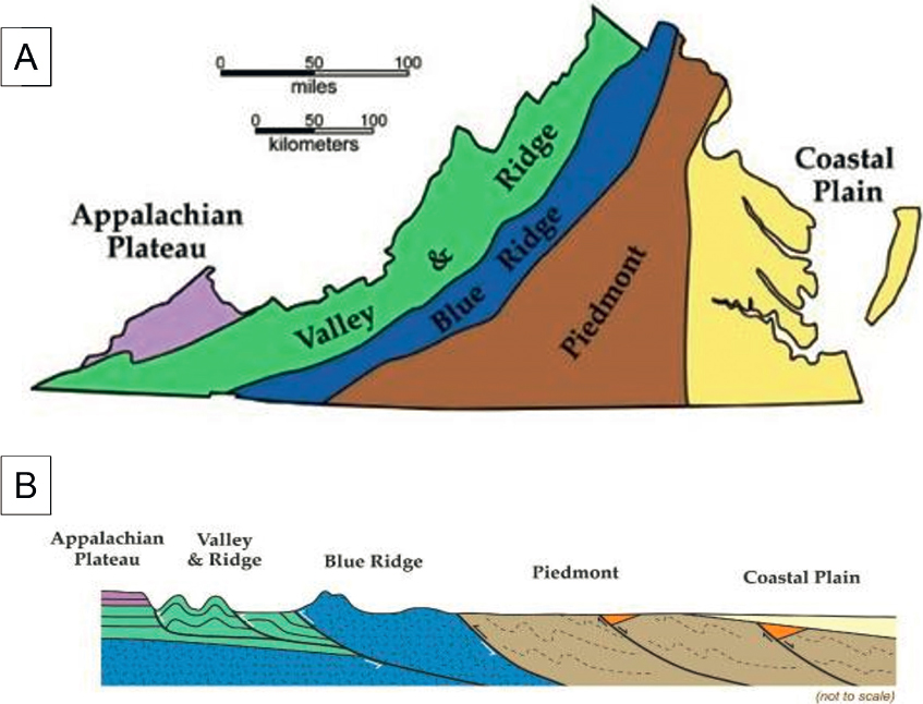
Virginia is divided into five physiographic provinces (see Figure 2-1). From east to west, the provinces are the Coastal Plain, Piedmont, Blue Ridge, Valley and Ridge, and Appalachian Plateau provinces. The Coastal Plain is the youngest of the provinces. It is an eastward thickening wedge of unconsolidated gravel, sand, silt, and clay deposits eroded from the mountainous regions to the west that overlies the eastward extension of Piedmont rocks.
The Piedmont is the largest physiographic province in Virginia and consists primarily of deformed metamorphic and igneous rocks. This region also contains fault-bounded Triassic-age (252–201 million years [Ma]) sedimentary basins that formed during the breakup of supercontinent Pangea, which ultimately resulted in the current day configuration of continents. The Blue Ridge province, to the west of the Piedmont, consists of Precambrian-age
SOURCE: Images courtesy of Christopher Bailey.
(>541 Ma) metamorphosed and highly deformed igneous rocks and lava flows. The Valley and Ridge region consists of folded Paleozoic-age (542–252 Ma) sedimentary rocks, including limestone, sandstone, and shale, and the Appalachian Plateau province, in the southwest corner of Virginia, is composed of Paleozoic- and Mesozoic-age (252–66 Ma) sedimentary rocks that are less deformed than those in the Valley and Ridge province.
Most of the gold deposits in Virginia occur in the Piedmont province (see Figure 2-1), particularly in the gold-pyrite belt in the north-central part of the state and the Virgilina district in south-central Virginia and north-central North Carolina (see Figure S-1). The geology of this region is described in greater detail below. Some prospects and small deposits occur in the Blue Ridge province, but no lode deposits are known to occur in the Valley and Ridge or Appalachian Plateau provinces. Gold deposits may exist in buried Piedmont rocks that extend beneath the Coastal Plain sediments, but this region has not been explored.
Virginia Piedmont Province
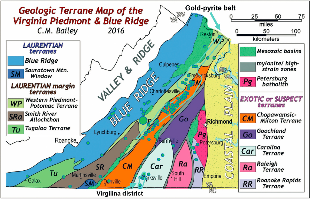
The Piedmont province is a geologically complex region consisting of approximately eight geologic terranes1 that became part of the North American craton (the continental core of North America) at different times. The accretion of the individual terranes was accompanied by intense deformation and varying degrees of metamorphism
___________________
1 Terranes are coherent units of rock that have a distinct geologic history.
(Horton et al., 2016). Boundaries between the individual terranes are defined by shear zones where the rocks are highly deformed. Characterizing the complex geology of this area is complicated by a nearly omnipresent layer of deeply weathered rock (saprolite) up to 20 meters thick that blankets much of the region and obscures the underlying bedrock geology.
Virginia’s Piedmont is divided into two regions by the central Piedmont shear zone (Hibbard et al., 2016), a major crustal break that runs north-south through much of the state. The Eastern Piedmont consists of multiple terranes, with the Carolina Terrane that includes a northern extension of the Carolina Slate Belt (Hackley et al., 2007) and hosts the Virgilina district gold deposits, being most relevant to this report. The Western Piedmont, stretching from the Washington, DC, area into North Carolina, is a tectonic transition zone that separates rocks of North American affinity (to the west) from rocks that originated offshore of present-day North America and were accreted to the eastern margin by plate tectonic processes (represented by the Eastern Piedmont; see Hughes et al., 2014).
Western Piedmont rocks consist of late Proterozoic- (2,500–542 Ma) and Paleozoic-age (542–251 Ma) metaclastics,2 metavolanic,3 and plutonic4 rocks (Hibbard et al., 2016). Hibbard et al. (2016) separate the Western Piedmont rocks into the metaclastic tract and the magmatic tract. The metaclastic tract to the west is composed mostly of metaclastics of late Proterozoic and early Paleozoic age. These include the Potomac Terrane to the north and the Smith River regional thrust sheet to the south. The Potomac Terrane is the host for gold deposits in this region. The magmatic tract to the east has a higher proportion of Paleozoic metamorphosed volcanic rocks and includes the Chopawamsic Formation and the Ta River Metamorphic Suite to the north and the Milton Terrane to the south. Most gold deposits in this region are located near the top of the Chopawamsic Formation, near its contact with the Quantico Formation rocks, which are metasedimentary5 rocks that overlie the magmatic track. This is particularly true where the Quantico units are silica rich and composed of rocks like quartzites and ferruginous quartzites (Hibbard et al., 2016). The contact between the metaclastic tract and the magmatic tract is represented by the Brookneal Shear Zone in the south and the Chopawamsic Fault in the north, with the southernmost boundary covered by Mesozoic sediments of the Danville Basin. These shear zones and faults likely played a major role in focusing fluid flow to produce gold mineralization, and many, if not most, of the gold occurrences in the gold-pyrite belt occur near these shear zones.
WHERE DOES GOLD OCCUR IN VIRGINIA?
The large majority of gold occurrences in Virginia are located in the Piedmont (see Figures S-1 and 2-2), specifically in the Western Piedmont. Virginia State Geologist David Spears notes that of 362 gold mines, prospects, and occurrences that are located in the Piedmont, 338 are located in the Western Piedmont and only 24 are located in the Eastern Piedmont (David Spears, personal communication, 2022). Gold occurrences are often spatially associated with metamorphosed volcanic rocks. The vast majority of Western Piedmont occurrences are hosted in the Ordovician-age (485–444 Ma) Chopawamsic Formation (magmatic tract) and only about 20, including Aston Bay’s exploration property in Buckingham County (largest green dot in Figure 2-2), are hosted in Potomac Terrane rocks (metaclastic tract) (David Spears, personal communication, 2022).
Gold-Pyrite Belt
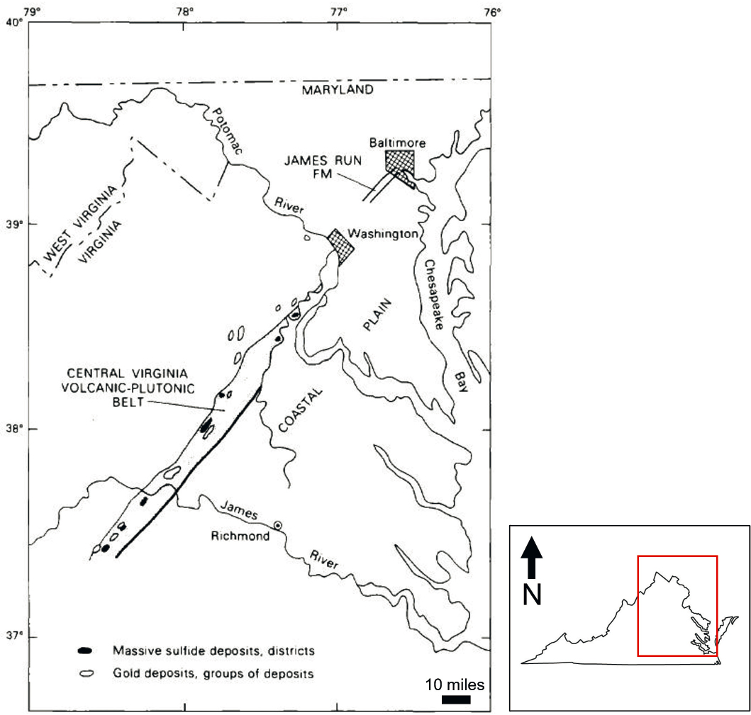
The Virginia gold-pyrite belt, which hosts the bulk of known gold occurrences in Virginia, is located in the Western Piedmont geologic province. It extends about 175 miles from just south of Washington, DC, to midway between the James and Roanoke Rivers, although the exact location of its southwest terminus is unknown because it is covered by Mesozoic-age (252–66 Ma) sedimentary rocks (Pavlides, 1981). This region hosts various types of ore deposits, including (1) low-sulfide, gold-quartz vein deposits with approximately 1–5 percent pyrite (see Box 2-1);
___________________
2 Metaclastic rocks are clastic sedimentary rocks that have been metamorphosed.
3 Metavolcanic rocks are igneous rocks that have been metamorphosed.
4 Plutonic rocks are magmatic rocks that formed at great depth.
5 Metasedimentary rocks are sedimentary rocks that have been metamorphosed.
SOURCE: Modified map courtesy of Christopher Bailey.
(2) volcanic massive sulfide deposits with up to 90 percent pyrite (that produce little to significant amounts of base metals6 and occasionally gold as a by-product) and (3) gold placer deposits generated by weathering and erosion of the in situ deposits (Park, 1936; Taber, 1913). The rocks that host the ores (called the “host rock”) are dominantly interlayered metamorphosed volcanic and metasedimentary rocks of the Chopawamsic Formation and associated small intrusive bodies interpreted to represent an island arc7 of late Proterozoic to early Cambrian age (~1,000–488 Ma) (Pavlides et al., 1982). Some deposits in the northern part of the gold-pyrite belt are hosted in Potomac Terrane rocks (see Figure 2-2).
The spatial association of the low-sulfide, gold-quartz veins and the massive sulfide deposits varies across the gold-pyrite belt. Gold-quartz veins generally occur to the west of massive sulfide deposits in the far north, spatially intermingled with massive sulfide deposits in the central part, and to the east of massive sulfides in the south (Pavlides et al., 1982; see Figures 2-3 and 2-4). Nevertheless, mining operations on gold veins and on the near-surface gossan (weathered and oxidized) iron ores usually reported bodies of pyrite at slight depths (Lonsdale, 1927). Perhaps the best example of the close relationships between gold mines and massive sulfide mines in the gold-pyrite belt is illustrated by an approximately 10-mile-long stretch in Buckingham County that includes the London and Virginia, Buckingham, and Williams Mines. The London and Virginia Mine near Dillwyn was first operated as a gold mine starting in 1853, producing gold from oxidized near-surface deposits using open cuts that were 20–40 feet deep and extending a distance of about 450 feet along strike (Taber, 1913). Discontinuous massive pyrite bodies, less than 1 meter thick and containing minor sphalerite, galena, chalcopyrite, tennantite, tetrahedrite, and native gold, occurred within the gold ore zone (Mangan et al., 1984). Brown (1969) reports that deep drilling at the London and Virginia and nearby Buckingham Mine properties in 1953 and 1955 identified 723,000 tons of ore containing 3.2 percent zinc, 20 percent pyrite, and fractional percentages of gold, silver, copper, and lead. The Williams Mine, which is located three-quarters of a mile along strike from the Buckingham Mine was explored for development of a pyrite mine. Material collected from the dump contains up to 80 to 85 percent pyrite, whereas the gold ores in these deposits only contain up to 4 to 5 percent pyrite (Taber, 1913). These examples show the wide variation in amounts of sulfides of closely spaced deposits that lie on an approximately 10-mile strike length and highlight the close spatial relationships of gold deposits and massive sulfide deposits in some regions of the gold-pyrite belt.
Given the close association between the two deposit types, it has been proposed that the low-sulfide gold-quartz veins and the massive sulfide deposits have a similar origin. Lonsdale (1927) outlined evidence that these two deposits may be derived from the same source, including observations that the gold veins and pyrite deposits are mineralogically similar and that they differ primarily in the relative proportions of quartz, feldspar, tourmaline, and sulfide minerals. In addition, Lonsdale (1927) highlighted observations from mine workers who describe quartz-gold veins associated with pyrite bodies, both of which are closely associated with granitic intrusions, and suggested that material in both quartz-gold veins and pyrite bodies may have been sourced from the igneous intrusions. Current theories, however, suggest that the igneous intrusions are not related to the formation of the ores, other than perhaps as providing a heat source or fluids that facilitated remobilization of metals from nearby volcanogenic massive sulfide deposits. Nevertheless, this remobilization of metals from the massive sulfide deposits, via the heat provided by the igneous intrusions or some other source, is the likely source of the gold and other metals associated with the gold-quartz veins (Good et al., 1977).
The Virgilina District
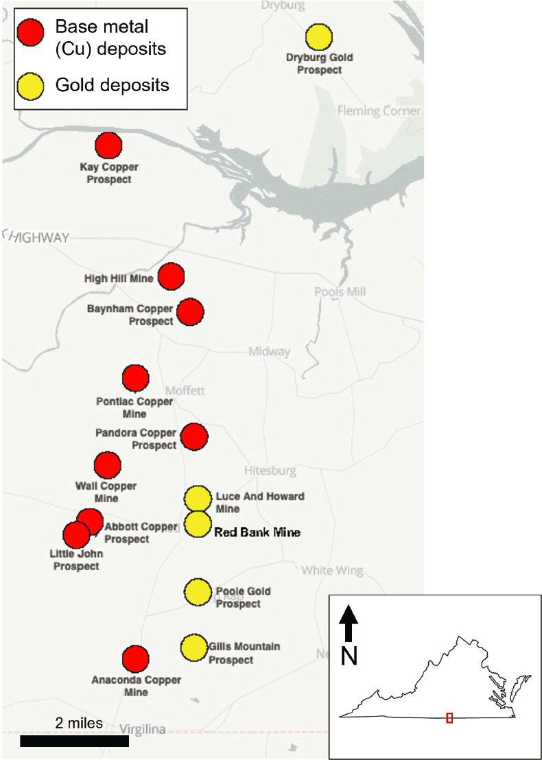
The Virgilina district, home to the second-largest concentration of historic gold mining sites in Virginia, is located in south-central Virginia in Halifax, Charlotte, and Mecklenburg Counties (see Figure S-1) and extends into Granville and Person Counties in North Carolina. The region is commonly known as the Virgilina Copper District because copper has been the main metal of economic importance; however, gold was also produced from some deposits in this area. The district lies within Precambrian- to Cambrian-age (>488 Ma) volcanic and metasedimentary
___________________
6 Mostly copper, zinc, and lead.
7 An island arc is a chain of volcanic islands that are found along tectonic plate margins.
SOURCE: Image from Pavlides et al. (1982).
rocks of the Carolina Terrane, which originated offshore of present-day North America and later accreted to the North American craton, and includes a northward extension of the Carolina slate belt (Hackley et al., 2007).
Copper and gold are the main deposits that have been identified in the Virgilina district. Both the copper and gold deposits in the Virgilina district are hosted in low-sulfide quartz veins, but low-sulfide quartz veins that bear gold are primarily hosted within a single metamorphosed basaltic member of the Aaron Formation. Minor copper is present in the gold-bearing quartz veins, and gold is present in trace amounts in the copper ores, suggesting the formation of the two ore types are related, similar to the relationship between gold and base metal ores in
SOURCE: Image modified from Sandhaus and Craig (1986).
the gold-pyrite belt (Laney, 1917; Linden et al., 1985). Also, similar to the gold-pyrite belt, a consistent spatial distribution of base metal deposits and gold deposits is observed in the Virgilina district, where copper mines are located along a linear trend to the west of the trend containing gold deposits and prospects (see Figure 2-5). Kish and Stein (1989) report that no massive sulfide ore bodies (such as those that are common in the gold-pyrite belt) are present in the Virgilina district. Thus, unlike the gold-pyrite belt, metals were likely leached and remobilized
SOURCE: Map from The Diggings (2022).
from the surrounding magnesium- and iron-rich volcanic rock during alteration and metamorphism, instead of from nearby massive sulfide deposits as occurs in the gold-pyrite belt.
The Red Bank Mine, active in the early 1900s, is one of the few historic gold mines of significance in the Virgilina district. It consisted of a gold-bearing quartz vein that varied from a few inches to 6 feet in width, averaging 3.5 feet. Sweet et al. (2016) report that 1,064 ounces of gold were produced from the Red Bank Mine between 1903 and 1912.
Miscellaneous Occurrences
Sweet (1980) lists four locations in Floyd County (Blue Ridge Terrane) as gold occurrences, but little information is available on the sites. Two of the locations, at Brush Creek and Laurel Creek, are listed as placer operations. Sweet (1980) also reports extensive placer workings along Brush Creek in Montgomery County, a location that is probably the same deposit as the Brush Creek site listed for Floyd County because Brush Creek is located along the Floyd–Montgomery County line. These placer gold deposits likely represent gold that has been eroded from small gold-quartz veins in the Blue Ridge. Sweet and Trimble (1982) report an unusual occurrence of gold at the Walt Williams prospect in Grayson County in which gold is hosted by a quartz pebble metaconglomerate (metamorphosed coarse-grained sedimentary rock) in the early Cambrian-age (542–488 Ma) Unicoi Formation.
Other occurrences that are outside of the gold-pyrite belt and the Virgilina district are likely associated with Blue Ridge Terrane rocks and include prospects in Rockingham, Nelson, Rockbridge, Botetourt, Bedford, Warren, Carroll, and Franklin Counties (Sweet and Lovett, 1985; Sweet and Trimble, 1982; see Figure 2-2). This includes small occurrences in Nelson and Bedford Counties that are likely gold-bearing quartz veins in Precambrian-age (>542 Ma) Blue Ridge Terrane rocks, the Baker Branch Prospect in Grayson County with iron-stained quartz veins in the Precambrian-age Mount Rogers metasediments, and the Gold Hill mine in Grayson County where quartz veins are hosted by the Precambrian-age Elk Park Plutonic Group. Young (1956) describes an unnamed deposit in Blue Ridge Terrane rocks in northern Floyd County as primarily consisting of arsenopyrite that was mined for arsenic, not gold. Arsenopyrite is a characteristic mineral in orogenic gold deposits that formed at greater depths, such as those that might be expected to occur in the Blue Ridge Terrane.
CHARACTERIZATION OF GOLD OCCURENCES IN VIRGINIA
Sillitoe (2020) notes that most gold deposits worldwide show distinctive and defining combinations of geologic features that make the type of deposit readily recognizable. However, in some places, these characteristic features have been modified via ductile deformation8 and metamorphism. Many sites in Virginia’s gold-pyrite belt and, to a lesser extent, the Virgilina district fall into this latter category. Thus, in order to characterize Virginia’s gold deposits and compare them with those found elsewhere, it is useful to consider the geologic history of Virginia’s gold deposits, including both the original environment in which the gold was formed and how it has been modified over time.
Evidence suggests that most of the gold in Virginia’s gold-pyrite belt and Virgilina district was originally deposited in submarine volcanic massive sulfide deposits or submarine equivalents of subaerial epithermal deposits, and subsequently remobilized during later metamorphism and deformation to form low-sulfide, gold-quartz vein deposits. This remobilization appears to have occurred after the host rocks experienced at least one episode of deformation and metamorphism (LeHuray, 1982). Gold deposits that are modified by, or form during, metamorphic and deformation processes associated with convergence of tectonic plates and formation of mountain belts are referred to as “orogenic” gold deposits. Orogenic gold deposits can form over a wide range of pressure/depth and temperature conditions (Goldfarb et al., 2005). While the Virginia gold deposits show many characteristics similar to greenschist-facies9 orogenic deposits, they may fall into the category of deposits that Groves et al. (2003) refer to as “enigmatic metamorphic gold deposits” involving overprinting of more than one style of mineralization and alteration.
___________________
8 Ductile deformation is when rocks bend and deform during intense pressure and temperature, instead of fracturing.
9 Greenschist-facies refers to low to medium metamorphism corresponding to temperatures of about 300–500°C and pressures of 3–20 kbar, which is typical of continental collision tectonics (Arndt, 2011).
Structural Setting of Gold Occurrences
The structures associated with gold deposits in Virginia likely formed in two distinct stages. During the first stage, as various terranes were accreted to North America, the area of interest was far below the Earth’s surface. At these depths, the rocks were hot and ductile. As the various terranes were assembled and slid past one another, the hot, ductile rocks at the interface underwent ductile deformation to form shear zones. Later, as the rocks were exhumed and the temperature and pressure decreased, the rocks became more brittle, resulting in the formation of cross faults that cut the shear zones at high angles. During this time, gold was remobilized and deposited with quartz to produce veins and brecciated10 filled fractures that cut the shear zone.
This complex geologic and tectonic history means that at the regional scale Virginia gold deposits occur along shear zones that extend for tens of kilometers, whereas at the local or mine scale mineralization is most closely associated with later faults, especially in the more broken areas where the shear zones are crossed by tension cracks. Park (1936) states that “work at the Melville Mine and at other mines in the southern Appalachian region seems to indicate that a relation of importance exists between the northwestward-striking tension cracks (or cross faults) and the best ores.” Similarly, in discussing protocols for exploration for orogenic gold deposits, Groves et al. (2020) report that “subparallel arrays of obliquely cross-cutting faults that develop where there are flexures or jogs on the first-order faults [i.e., in the case of the gold-pyrite belt the major NE-trending shear zone], in many instances provide the most important structural geometries in terms of predictive exploration.” While this statement refers to exploration at the district scale, it also applies at the deposit scale.
Size and Geometry of Deposits
The size, shape, depth beneath the surface, and other properties of an occurrence of gold are critical for determining the economic feasibility of extracting gold and influence the type of mining and processing that must be undertaken to extract the ore. The size and shape of the ore body also determine how much surface area must be disturbed to mine the deposit and provide storage facilities for waste and tailings.
Little information is available concerning the surface footprint of historical gold mining operations in Virginia. Park (1936) reported that the Melville Mine tract in Orange County was developed on 844 acres leased by the Rapidan Gold Corporation, but did not state what portion of this area was actually occupied by mine facilities (shafts, trenches, waste dumps, processing facilities, etc.). The Vaucluse Mine tract in Orange County—noted to have the most extensive surface workings of all mines in the gold-pyrite belt—was described as occupying 200 acres (Park, 1936) but, again, the portion of this area occupied by mining-related infrastructure is unknown. A map of shafts, workings, and dumps at the Moss Mine in Goochland County circa 1935 (Pardee and Park, 1948) shows a disturbed area of about 500 × 700 square feet (8 acres), though the underground area may be smaller or larger than the surface area, depending on the extent of underground workings. Park (1936) reports that the two mined veins at Moss extended 1,500 to 2,500 feet—assuming that the veins were exploited along this entire length, the size (area) of the underground footprint could be much larger than the surface footprint.
In terms of shape, Lonsdale (1927) describes the gold veins in the gold-pyrite belt as being lens shaped, with long dimensions that range from a few inches to several hundred yards (see Figure 2-6). Mining showed that the lenses or veins are not continuous. Often, a lens (vein) will pinch out and another vein will begin at some distance away, or at some distance above or beneath the mined-out lens. The pinching and swelling of quartz veins is present at scales ranging from a few inches to thousands of feet. The veins did not fill open spaces or fissures, and instead replaced in situ material at considerable depth during metamorphism when open space (fissures) did not exist. Park (1936) also describes single quartz veins that branch to form numerous continuous smaller quartz veins that decrease in size along strike11 (see Figure 2-7). Pyrite ore bodies have the same shape as the gold ore bodies in the same mine or district, but typically the pyrite bodies are larger and can reach up to 1,000 feet long (Lonsdale, 1927).
___________________
10 Breccia is sharp-angled fragmented rock.
11 Strike is the orientation of an imaginary horizontal line across the plan of a geologic feature.
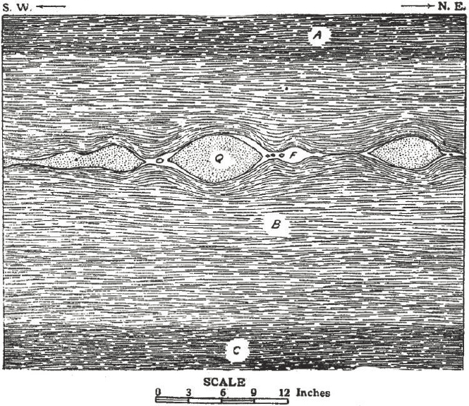
NOTE: A = hanging wall schist; B = bed of lighter colored schist; C = footwall schist; F = feldspar; Q = quartz.
SOURCE: Image from Taber (1913).
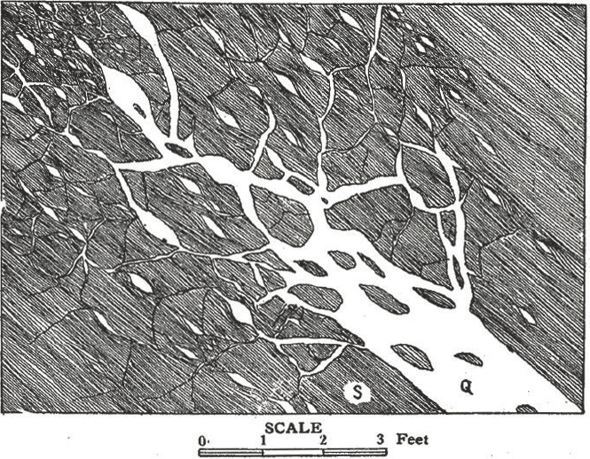
SOURCE: Image from Taber (1913).
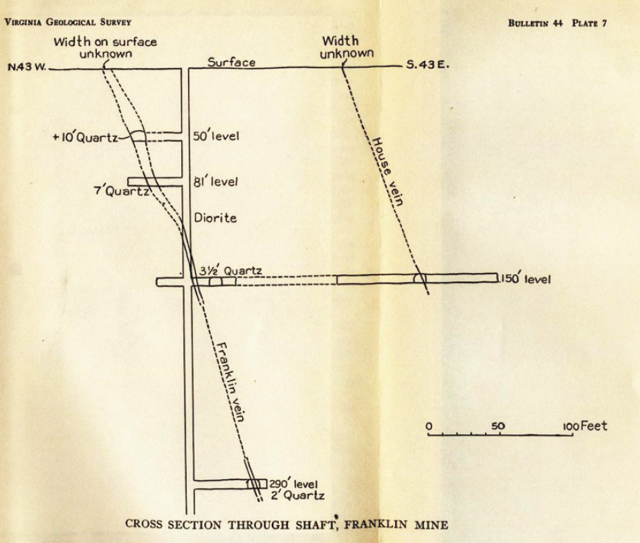
SOURCE: Image from Park (1936).
Descriptions of the Franklin Mine in Fauquier County illustrate the pinch-and-swell nature of the gold-quartz veins. This mine worked two steeply dipping12 parallel veins, referred to as the Franklin vein and the House vein (Park, 1936; see Figure 2-8). These veins were initially accessed through shallow surface trenches, but a shaft to a depth of ~300 feet below the surface was developed to access deeper ore, with crosscuts excavated to intersect and mine the ore at depths of 50, 81, 150, and 290 feet. The Franklin vein was found to narrow from 16 feet on the 50-foot level to essentially zero at the 130-foot depth, then expand to 7 feet wide on the 150-foot level. On the 290-foot level, the quartz vein was very discontinuous and the bodies became more lens-like, varying from over 5 feet wide to a few inches over a distance of a few feet.
Another recent detailed description of a gold mine in the gold-pyrite belt is available for the Vaucluse Mine (sometimes referred to as the Grimes or Grymes Mine) in Orange County (Bass, 1940). The Vaucluse Mine was operated intermittently starting in 1832, producing gold from placers and near-surface oxidized ore. Starting in 1844, gold was mined from two open cuts, each about 60 feet deep, 75 feet wide, and 120 feet long. By 1854, six shafts had been sunk to access deeper ore. The mine closed during the Civil War and was not reopened until
___________________
12 The dip is the angle of inclination measured from horizontal of a planar geologic feature.
SOURCE: Photos by Robert J. Bodnar.
the 1930s. Between December 1935 and December 1938 the mine produced a total of 25,452 tons of ore containing 4,305.3 ounces of gold. Ore was contained in steeply dipping veins averaging 4 feet wide by 50 feet long, and varying in width from a few inches to 30 feet, and in length from a few inches to more than 200 feet. Exploratory drilling beneath the 300-foot level indicated that the ore continued to a depth of at least 600 feet. More recently, in the 1980s, four exploration drill holes were drilled to depths ranging from 601 to 754 feet and intersected the gold-bearing veins well below the deepest levels that had been previously mined (see Figure 2-9).
Gold Production in Virginia
Park (1936) reports total gold production from the gold-pyrite belt during the period 1829–1934 as 91,208 total ounces, with the maximum in any one year being 6,259 ounces in 1849. After 1860, total production in a single year never exceeded 1,000 ounces. Production in the Virgilina district (mostly from the Red Bank and Luce-Howard Mines) through 1912 amounted to a little over 1,000 ounces of gold in total. Park (1936) also reports the gold production for the entire state from 1829 to 1934 was valued at $3,318,388. The fixed price of gold from 1834 to 1933 was $20.67 per ounce; therefore, the reported gold production in dollars corresponds to about 160,000 ounces of gold produced in Virginia over a 105-year period. For comparison, the Turquoise Ridge Gold Mine in Nevada produced 287,144 ounces of gold in 2020, the Carlin trend gold mines in Nevada (which include the Arturo JV, Betze Post, Carlin Trend Operations, and Meikle mines) produced more than 1.6 million ounces of gold in 2020 (Nevada Division of Minerals, 2020), and the Haile Mine in South Carolina produced 137,413 ounces of gold in
TABLE 2-1 Calculated Average Grade Based on Reported Average Ore Value per Ton and Average Gold Price from 1834 to 1933 of $20.67 per Ounce
| Average Ore (dollars/ton) |
Average Calculated Grade (oz/ton) |
Average Calculated Grade (g/t) |
|
|---|---|---|---|
| Culpeper Mine vein (Culpeper County) | $6 | 0.29 | 9.94 |
| Franklin Mine (Fauquier County) | $12 | 0.58 | 19.89 |
| Grasty Tract (Orange County) | $6–$32 | 0.29–1.55 | 9.94–53.14 |
| Vaucluse Mine (Orange County) | $8 | 0.39 | 13.37 |
| Red Bank Mine (Virgilina district) | $8 | 0.39 | 13.37 |
SOURCES: Linden et al. (1985); Lonsdale (1927).
2020 (OceanaGold, 2022a) and 189,975 ounces in 2021 (Junior Mining Network, 2022). Thus, the Haile Mine produces as much or more gold in one year as the total production during the 105-year history of gold mining in Virginia. As such, individual gold deposits in Virginia are very small compared to gold deposits that are currently being mined in the western United States and in South Carolina, and the scale of mining operations in Virginia would be commensurately smaller compared to mines operating in the western United States and the Haile Mine in South Carolina.
Grades for most gold mines that operated in Virginia during the 1800s through the mid-1900s are reported in dollars, rather than in the more conventional units of weight (grams/ounces) used today. While it is not stated directly, the values are also likely reported in short tons, rather than in metric tons. Thus, estimated grades of ore mined in the gold-pyrite belt and in the Virgilina district ranged from a few tenths to over an ounce per ton, or roughly 10–50 g/t (see Table 2-1). Recent exploration drilling in Virginia has intercepted similar or greater grades in quartz veins over short distances (see Box 2-2). These grades are comparable to some of the highest-grade underground gold mines operating in the United States today, including the Fire Creek Mine (44 g/t), Turquoise Ridge Mine (16.9 g/t), Pinson Mine (13.8 g/t), and Midas Mine (11.1 g/t), all of which are located in Nevada (Basoy, 2015). In contrast, the Haile Mine in South Carolina reports an average grade of 1.37 g/t for the open pit, with a cutoff grade of 0.45 g/t for December 2019 through June 2020 (Cision PR Newswire, 2020).
Although data are limited, the total cumulative amount of ore extracted at Virginia gold mines is estimated to range from one hundred to several hundred thousands of tons of ore. For comparison, in 2021 the Haile Mine in South Carolina produced 3,214,000 tons of ore, an amount estimated to exceed the total amount of ore produced in the more than 100-year history of gold mining in Virginia. Thus, while gold grades being mined in the 1800s and early 1900s in Virginia were comparable to grades being mined elsewhere in the United States today, the total ore tonnage mined at the Virginia gold mines was small compared to most mines operating in the United States today.
Mineralogy of the Gold Deposits
Some amount of host rock must necessarily be disturbed and extracted along with the ore during mining, and this material eventually ends up in waste rock piles or tailings. As such, the lithology and mineralogy of the host rock can affect the local environment, including surface water and groundwater. The host rocks for Virginia’s gold deposits are mostly metamorphic rocks containing (in decreasing order of abundance) quartz, sericite, potassium- and sodium-rich feldspars, chlorite, hornblende, biotite, garnet, tourmaline, and kyanite. Many of these same minerals are also included in the alteration assemblage associated with gold ore as described below, and all of the minerals listed above are common rock-forming minerals that are relatively stable at surface conditions and contain few elements that might contribute to contamination of the local soils and waters during mining. Host rocks for gold mineralization in the gold-pyrite belt are dominantly highly deformed metamorphic rocks, and less often igneous plutonic rocks that have been intruded into the metamorphic rocks. All of the host rocks show distinct, foliated fabrics characterized by parallel bands of minerals, especially quartz and fine-grained mica (muscovite, illite, or sericite) that are indicative of their strongly deformed nature. The dominant host rocks for gold deposits
in the gold-pyrite belt (Chopawamsic Formation and Potomac Formation) show a higher degree of metamorphism and deformation compared to Carolina Terrane host rocks in the Virgilina district. As a result, the Virgilina deposits retain more of the original characteristics of formation compared to deposits in the gold-pyrite belt.
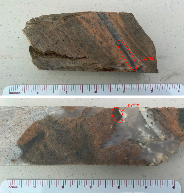
The potential contamination of local soils and waters during mining is not only dependent on the nature of the rocks that host the gold deposit, but also the mineralogy of the gold ore and associated alteration minerals. Gold is the only ore mineral that is sought in the gold deposits of the gold-pyrite belt. In the near-surface weathered and oxidized zone of the gold-pyrite belt, gold occurs as free native gold, and below the water table, where the rock has not been oxidized, gold mostly occurs within pyrite. Taber (1913) reports that pyrite is the main sulfide in Virginia gold-quartz veins and is always present in small quantities in gold ores, often averaging ~1 percent. This observation agrees with the committee’s study of drill cores from the Vaucluse Mine to Virginia Energy in Charlottesville on March 30, 2022, as well as the committee trip to the exploration property of Aston Bay Holdings, Ltd., on April 28, 2022. Nevertheless, as discussed above, the gold-quartz veins can be in close proximity to massive sulfide deposits, which may have >90 percent pyrite. As noted by Park (1936), the mineralogy of gold-containing ores in Virginia
is relatively simple. The most abundant gangue (non-commercially valuable) mineral is quartz, which varies from white to light gray to bluish gray in the nonoxidized zone and in the oxidized zone takes on a reddish color from iron oxides along cracks. Sericite (fine-grained white mica) is the second-most abundant gangue mineral, and is most abundant near the vein walls and in the sericitized host rock that surrounds the quartz lens. Carbonates, including ankerite (Ca-Mg-Mn-Fe carbonate) and calcite, are the next most common phase, and in some deposits represent the main gangue mineral. Ankerite often occurs between the quartz lens and the silicified country rock. Chlorite is observed in all deposits, and often is partially replaced by sericite. In some deposits, biotite, garnet, tourmaline, and hornblende have been identified in the host rock adjacent to veins and lenses. Hydrous iron and manganese oxides are common in veins and lenses that are near the surface (above the water table). Chalcopyrite is often present in small amounts, and minor ilmenite, magnetite, tetradymite (Bi2Te2S), and arsenopyrite have been reported. Pardee and Park (1948) suggest that the sericite, quartz, and chlorite immediately adjacent to the quartz veins represent alteration of the original host rock.
At the Red Bank and Luce-Howard Mines in the Virgilina district, very fine-grained native gold occurs with hematite (iron oxide) near the surface. With increasing depth, pyrite becomes more common, and the gold is contained in pyrite, similar to gold occurrences in the gold-pyrite belt. In contrast to the gold-pyrite belt, quartz veins in the Virgilina district contain minor bornite and other copper-bearing minerals that represent the major ore minerals in the copper deposits in the district (Johnson, 1983).
Geochemistry of the Gold Deposits
Minor and trace elements that may occur in gold ores and adjacent host rocks associated with the low-sulfide, gold-quartz deposits in the gold-pyrite belt and Virgilina district include antimony, arsenic, cadmium, chromium, cobalt, copper, bismuth, boron, lead, molybdenum, nickel, platinum-group elements, scandium, selenium, tellurium, thallium, tungsten, vanadium, and zinc (Ashley, 2002). Of these elements, those that are most likely to be present in the ores at concentrations exceeding 100 milligrams per kilogram (mg/kg), and perhaps reaching a few thousand mg/kg, include arsenic, copper, zinc, and lead. The absolute abundances of these elements vary depending on the specific geologic environment and historical use of the site. For example, in some low-sulfide, gold-quartz vein deposits, the arsenic content of the ore can be as high as 1 percent, whereas arsenic-bearing minerals (e.g., arsenopyrite) are rare in the Virginia deposits. Additionally, even though no natural mercury-rich minerals have been reported in gold deposits in Virginia, the historic use of mercury in the amalgamation process has contaminated soils, water, and waste materials in historic gold mining regions (Hammarstrom et al., 2006; Seal et al., 1998; VDH, 2022b; Virginia Energy, 2022e). For example, elevated levels of mercury have been identified in the pond sediment at the site of the Mitchell Gold Mine (Hammarstrom et al., 2006), soil near the Greenwood Gold Mine (Seal et al., 1998), and in stream sediments near the Vaucluse Mine (Virginia Energy, 2022e).
The base metal content of deposits is generally correlated with the amount of pyrite in the rock (Plumlee et al., 1999). Ores in low-sulfide gold deposits consist mostly of quartz containing a few percent pyrite, often with only trace or minor amounts of copper, zinc, and lead sulfide minerals, and often with significant amounts of carbonate minerals. Thus, mining these deposits generally results in insignificant acid rock drainage with low to undetectable metal contents in the waters (see Box 2-3). Conversely, volcanogenic massive sulfide deposits can contain more than 90 percent total sulfides, with most being pyrite but sometimes containing up to a few tens of weight percent of copper, zinc, and lead sulfides, with very little carbonate present. As such, mining of these volcanogenic massive sulfide deposits can lead to significant acid rock drainage and elevated metal contents in waters that traverse the mine site.
Data reported from the Greenwood Mine low-sulfide, gold-quartz vein deposit (Prince William County), and the massive sulfides at the Cabin Branch Pyrite Mine (Prince William County) and Valzinco Lead-Zinc Mine (Spotsylvania County) provide some useful geochemical information to assess the potential water quality impacts of gold mining in Virginia. Many of the elements that are of interest to human health and the environment (e.g., arsenic, cadmium, copper) are found at low levels in the host rock and quartz veins of low-sulfide gold deposits at the Greenwood Mine in Prince William County (Seal and Hammarstrom, 2002; see Table 2-2). Conversely, the nearby massive sulfide deposits—the Cabin Branch Pyrite Mine and the Valzinco Lead-Zinc Mine—have elevated
In addition to considering the minor and trace element content in gold deposits, it is also important to consider the stability of the minerals that host those elements. If an element of interest occurs in a stable mineral phase that will not be altered during mining, processing, and later long-term storage of waste rock and tailings, it will have less of an impact on water quality compared to a mineral that is easily altered during these events. For example, pyrite and arsenopyrite, which can host many metals of concern (e.g., arsenic, cadmium, selenium, thallium), are unstable in a humid, oxidizing near-surface environment. These minerals will quickly break down to produce various iron oxyhydroxide mineral phases, with the concomitant release of the metals and other trace elements to the local environment. Other sulfides (e.g., galena, pyrrhotite, sphalerite, chalcopyrite) are also susceptible to oxidization and can release metals (e.g., cadmium, copper, lead, selenium, thallium, zinc) when exposed to air, albeit at a slower rate than pyrite (Koski et al., 2008). Conversely, minerals such as native copper, chalcocite, cuprite, malachite, and azurite are more stable at near-surface conditions and may release insignificant amounts of elements of interest into the environment (see Appendix C). Another major factor that determines abundances of dissolved metals in mine drainage waters and natural waters draining unmined mineralized sites is the formation of acid rock drainage (see Box 2-3), which results in low-pH water. Concentrations of iron, aluminum, manganese, zinc, and copper have been shown to increase by up to six orders of magnitude as the pH decreases from slightly alkaline to near-neutral values to highly acidic pH values (Plumlee et al., 1999). Nevertheless, although acidity tends to increase the concentrations of metals solubilized and transported in drainage, metals can be mobilized and released in the absence of ARD (Ashley, 2002; Ashley and Savage, 2001).
While few data are available for mine drainage waters associated with gold-quartz vein deposits in Virginia, one study examined this issue for the Greenwood Mine in Prince William County (see Table 2-3), as part of a plan to incorporate the mine area into the Prince William Forest Park (Seal et al., 1998). While the focus of the study was on mercury contamination, various water samples were collected and analyzed for an extensive suite of elements of environmental concern. Water collected from two shafts at the Greenwood Mine had pH values of 5.9 and 6.1 (similar to the pH of rainwater). Metal concentrations were below current EPA Maximum Contaminant
TABLE 2-2 Metal Concentrations in Solid Material Collected at Low-Sulfide Quartz Vein Gold Deposits and at Massive Sulfide Deposits
| Deposit Type | Mine (sample type and name) | Al (wt.%) |
As (mg/kg) |
Cd (mg/kg) |
Cu (mg/kg) |
Pb (mg/kg) |
Sb (mg/kg) |
Se (mg/kg) |
Tl (mg/kg) |
Zn (mg/kg) |
|---|---|---|---|---|---|---|---|---|---|---|
| Low-sulfide, gold-quartz vein deposit | Greenwood granite wallrock (sample PW-GM1) | 6.3 | <10 | <2 | 8 | 27 | — | — | — | — |
| Greenwood vein quartz (sample PW-GM2A) | 1 | <10 | <2 | 3 | 6 | — | — | — | — | |
| Greenwood quartz from waste pile (sample PW-GM3) | 0.03 | <10 | <2 | <2 | <4 | — | — | — | — | |
| Massive sulfide deposit | Valzinco (sample 99VLZN9) | 0.13 | 62 | 160 | 15,000 | 260 | 4.2 | 33 | <2 | 69,000 |
| Valzinco tailings | 1.6–8.6 | 19–46 | 0.4–110 | 280–2,000 | 2,400–16,000 | 5.5–21 | — | 0.75–1.9 | 230–21,000 | |
| Cabin Branch (sample CB-ORE-1) | 0.19 | 262 | 173 | 3,840 | 2,560 | — | — | — | — | |
| Cabin Branch (sample CB-ORE-2) | 0.22 | 149 | 19 | 11,000 | 2,010 | — | — | — | — |
NOTES: Where applicable, data are reported as range. Dashes indicate not analyzed.
SOURCE: Data from Seal and Hammarstrom (2002).
TABLE 2-3 Metal Concentrations and pH in Water Samples Collected at and Near the Greenwood Low-Sulfide Quartz-Vein Gold Mine in Prince William County
| Sample Name | pH | Al (mg/L) |
As (mg/L) |
Cd (mg/L) |
Cu (mg/L) |
Pb (mg/L) |
Sb (mg/L) |
Se (mg/L) |
Tl (mg/L) |
Zn (mg/L) |
|---|---|---|---|---|---|---|---|---|---|---|
| VA Surface Water Quality Criteria (9 VAC 25-260-140) | — | — | 0.01 | 0.005 | 1.3 | 0.015 | 0.0056 | 0.17 | 0.00024 | 7.4 |
| MCL (40 CFR § 141.62) | — | — | 0.01 | 0.005 | 1.3 | 0.015 | 0.006 | 0.05 | 0.002 | — |
| Collected from main shaft (PWGM-1-1) | 6.1 | 0.290 | 0.0004 | 0.0001 | 0.008 | 0.0083 | 0.0002 | 0.0003 | <0.00005 | 0.027 |
| Collected from small shaft north of main shaft (PWGM-4-1) | 5.9 | 0.220 | 0.001 | <0.00002 | 0.0007 | 0.0004 | 0.00009 | 0.0006 | <0.00005 | 0.003 |
| Collected from Quantico Creek, downstream of mine (PWGM-2-1) | 6.2 | 0.045 | <0.0002 | 0.0002 | 0.003 | 0.0002 | 0.0001 | 0.0005 | <0.00005 | 0.041 |
| Background value: Collected upstream from mine (PWGM-3-1) | 6.4 | 0.180 | <0.0002 | 0.00003 | 0.002 | 0.0003 | 0.0002 | 0.0004 | <0.00005 | 0.005 |
NOTES: The water data are compared to the Virginia Criteria for Surface Water for public water supply and the EPA Maximum Contaminant Level (MCL) shaded in grey. None of the water samples from Greenwood exceeds either standards. Dashes indicate not analyzed or not applicable.
SOURCE: Data are from Seal et al. (1998).
Levels (MCLs; 40 CFR § 141.62) and Virginia Criteria for Surface Water (9 VAC 25-260-140) that are set to protect human health. The total base metal content of the mine shaft waters at the Greenwood Mine range from 0.014 to 0.046 mg/L. Seal et al. (1998) concluded that the mine drainage waters posed no significant environmental threat. The committee views the concentrations measured in water samples at the Greenwood Mine as reflective of a scenario in which only the low-sulfide, gold-quartz vein and adjacent wallrock are disturbed during gold mining in Virginia.
Owing to the close spatial relationship of the gold-quartz vein deposits with massive sulfide deposits in the gold-pyrite belt, it is possible that some sulfide-rich material could be intersected and disturbed during mining of the low-sulfide, gold-quartz vein deposits. This could cause greater potential for acid generation and other environmental impacts (see Box 2-3). Should this occur, significant ARD may result and cause mobilization of metals into local waters. This may be the cause of the “extremely acidic drainage” noted in 2019 at the historical Vaucluse Gold Mine site (Virginia Energy, 2022e) despite the low concentration of pyrite observed in the ore. The committee considered water samples taken downstream of the Cabin Branch Mine and Valzinco Mine massive sulfide deposits (see Table 2-4) as representative of the ARD that could occur if these massive sulfide deposits are disturbed. These samples show water pH as low as 2.4 and concentrations of cadmium, copper, lead, thallium, and zinc that exceed the U.S. Environmental Protection Agency MCLs (40 CFR § 141.62) or Virginia Criteria for Surface Water (9 VAC 25-260-140). The total base metal content of groundwater samples from the Cabin Branch massive sulfide mine ranges from 0.058 to 14.434 mg/L, much greater than that measured at the low-sulfide Greenwood Mine. The potential ecological and human health impacts of the mobilization of these metals is considered further in Chapter 4.
The committee notes that two samples from the Valzinco Mine (VLZN-10-2RA and VLZN-10-2FA) were not considered relevant to our analysis (see Appendix D). These samples were collected from stagnant puddles immediately on top of mine tailings. The committee determined that these two samples represented an anomalous geological setting that should not be directly compared to surface water or groundwater standards, given that these puddles likely experienced some degree of concentration due to repeated evaporation and little dilution.
COMPARABLE DEPOSITS AROUND THE WORLD
As directed by the Statement of Task (see Box 1-3), the committee sought to identify gold deposits that displayed comparable geologic, mineralogical, hydrologic, and climatic characteristics to those in Virginia. When examined in detail, subtle to significant differences are observed in every deposit (see detailed descriptions of deposits in Appendix E), such that no single gold deposit is fully comparable with the known deposits in Virginia. For example, while South Carolina gold mines are the closest modern commercial gold mines and occur under a similar climate and hydrology, they are not a good analogue for the geologic characteristics of known Virginia deposits (see Box 2-4). Nevertheless, South Carolina gold deposits are discussed here and in subsequent chapters of the report because of the similar hydrology and climate of South Carolina, and because various stakeholders—including Aston Bay Holdings, Ltd.—have referenced South Carolina mines when discussing the potential for gold mining in Virginia (Vogelsong, 2021).
As approximately 75 percent of all gold mined in the United States is mined in Nevada, it is worth noting why the many dozens of active gold mines in Nevada are not considered to be comparable deposits in those in Virginia. As noted above, many different types of gold deposits exist, with each type characterized by specific geological, geochemical, mineralogical, and other features. The largest and most-well-known gold deposits in Nevada are classified as Carlin-type deposits. Carlin deposits, also sometimes referred to as “invisible gold” deposits, are hosted in carbonaceous sedimentary rocks that have undergone little to no metamorphism and deformation. The geological and geochemical characteristics of this type of gold deposit are very different from gold deposits in Virginia and will not be considered further.
As discussed in this chapter, gold occurrences in the gold-pyrite belt and the Virgilina district most closely resemble the low-sulfide, gold-quartz vein deposit type (i.e., orogenic gold deposits). We note here that a common characteristic of orogenic gold deposits is that the gold in the deposit has been remobilized from some other source—this source might be gold-bearing country rocks or a previously formed gold deposit that has
TABLE 2-4 Metal Concentrations and pH in Water Samples Immediately Downstream from the Valzinco Mine (Spotsylvania County) and the Cabin Branch Mine (Prince William County) Massive Sulfide Deposits
| Sample | Comments (sample name) |
pH | Al (mg/L) |
As (mg/L) |
Cd (mg/L) |
Cu (mg/L) |
Pb (mg/L) |
Sb (mg/L) |
Se (mg/L) |
Tl (mg/L) |
Zn (mg/L) |
|---|---|---|---|---|---|---|---|---|---|---|---|
| VA Surface Water Quality Criteria (9 VAC 25-260-140) | — | — | — | 0.01 | 0.005 | 1.3 | 0.015 | 0.0056 | 0.17 | 0.00024 | 7.4 |
| MCL (40 CFR § 141.62) | — | — | — | 0.01 | 0.005 | 1.3 | 0.015 | 0.006 | 0.05 | 0.002 | — |
| Valzinco downstream water | Collected in Knights Branch immediately downstream of the tailings (sample VLZN-3) | 2.6–3.9 | 0.70–19.47 | <0.0002–0.001 | 0.0032–0.088 | 0.049–2.2 | 0.17–1.3 | <0.00003–0.00069 | <0.0002–0.0007 | <0.00005–0.0003 | 1.9–7.0 |
| Valzinco water downstream | Collected in Knights Branch ~1 km downstream of the tailings (sample VLZN-11) | 2.4–3.6 | 0.52–31.15 | <0.0002–0.0009 | 0.0017–0.099 | 0.038–2.8 | 0.13–1.6 | <0.00002–0.00031 | <0.0002–0.0004 | <0.00005–0.00009 | 0.99–27.0 |
| Cabin Branch water | Groundwater | 4.1–7.0 | <0.00001–5.50 | — | 0.2–20.0 | 0.003–3.3 | <0.00005–12.0 | — | — | — | 0.036–11.0 |
| Cabin Branch water | Seep | 5.7–6.9 | <0.00001–1.10 | — | 0.2–35.0 | 0.001–1.3 | <0.00005–0.0028 | — | — | — | 0.39–13.0 |
NOTES: The water data are compared to the Virginia Criteria for Surface Water for public water supply and the EPA Maximum Contaminant Level (MCL) shaded in grey. Water values are highlighted in red if they exceed the EPA MCL or Virginia’s surface water quality criteria for human health. Where applicable, data are reported as a range. Dashes indicate not analyzed or not applicable.
SOURCES: Valzinco data are from Seal and Hammarstrom (2002) and Seal et al. (2002). Cabin Branch data are from Seal et al. (1998).
been metamorphosed. As such, the Virginia gold deposits are thought to have originally formed as submarine volcanic massive sulfide deposits or submarine equivalents of subaerial epithermal deposits. Similarly, the Haile and other deposits in South Carolina are thought to have originally formed as epithermal deposits. However, both have subsequently been metamorphosed and the gold remobilized to form the orogenic-style type of mineralization observed today. These orogenic types of deposits are commonly associated with regional shear zones. For example, gold deposits in the gold-pyrite belt are associated with shear zones and the gold occurs in brecciated lodes, in veins, and disseminated in wallrock. This makes the known Virginia deposits comparable to a large number of intermediate-depth orogenic gold deposits (Goldfarb et al., 2005). As noted above, Virginia low-sulfide, gold-quartz vein deposits are found in close association with massive sulfide deposits (gold-pyrite belt) or with copper-rich base metal deposits (Virgilina district) and the gold in the gold-quartz veins may have been remobilized from those deposits. A similar source for gold has been proposed for the Mic Mac and Mooshla A and B deposits in the Doyon-Bousquet-LaRonde gold camp of Quebec, where Tourigny et al. (1989) suggest that the gold was remobilized from gold-bearing sulfides in the volcanic massive sulfide deposit and deposited in quartz veins to produce low-sulfide, gold-quartz veins. A similar occurrence is reported for deposits in the Nubian Shield region of northeast Africa, where volcanic massive sulfide deposits are comingled with and overprinted by orogenic gold veins, similar to what is observed in the gold-pyrite belt (see Figures 2-3, 2-4, and 2-5).
The mineralogy and geochemistry of the gold deposits in the gold-pyrite belt are characterized by post-metamorphic mineralization consisting of quartz-carbonate-sericite wallrock alteration, with common opaque minerals that include pyrite and iron and titanium oxide minerals. These are features that characterize orogenic deposits formed at shallow to intermediate depths of 5–12 km (Goldfarb et al., 2005). Minerals that are common to essentially all gold deposits in the gold-pyrite belt of Virginia include quartz, sericite (fine-grained white mica), pyrite, calcite, ankerite (Ca-Mg-Mn-Fe carbonate), and chlorite (often gives the rock a greenish color). In some deposits, biotite, garnet, tourmaline, and hornblende have been identified in the host rock adjacent to veins and lenses. Hydrous iron and manganese oxides are common in veins and lenses that are near the surface (above the water table). Chalcopyrite, sphalerite, and galena are often present in small amounts, and minor ilmenite, magnetite, tetradymite (Bi2Te2S), and arsenopyrite have been reported (Bass, 1940; Lonsdale, 1927; Pardee and Park, 1948; Park, 1936; Taber, 1913). As such, the mineralogy and geology of gold deposits in the gold-pyrite belt are comparable to that of a large number of orogenic deposits, including the Racetrack, Granny Smith, Mt. Charlotte, Golden Mile, Lancefield, Porphyry, Sons of Gwalia, Great Eastern, and Norseman deposits in the Yilgarn block of Australia (Goldfarb et al., 2005). Nevertheless, gold deposits in the gold-pyrite belt do not conform to all common characteristics of orogenic gold deposits. For example, many orogenic deposits show significant enrichment in arsenic, with arsenopyrite as a major sulfide phase, whereas arsenopyrite is rare in the Virginia deposits.
Finally, in terms of the size and scale of the deposits, the Kensington Mine in southeast Alaska is a currently active mine that is a good analogue. The Kensington Mine consists of several spatially associated ore bodies. The vein system in these ore bodies is a steeply dipping network of quartz extension veins and shear veins. Measured and indicated resources13 at the Kensington Mine as of December 31, 2021, include 660,000 ounces measured and 323,000 ounces indicated, for a total of 983,000 ounces (Pascoe et al., 2022), which is approximately one to two orders of magnitude larger than those of the known deposits in Virginia.
SUMMARY OF FINDINGS
Several hundred gold mines and prospects have been documented in Virginia, with the large majority located in the gold-pyrite belt. The amount of information available about these sites is highly variable. For some, the documentation merely provides evidence that a small gold mining operation existed at some time in the past, often in the early to mid-1800s. Other sites have been documented in much greater detail. For example, the Vaucluse Mine in Orange County is described in several publications (Bass, 1940; Lonsdale, 1927; Pardee and Park, 1948; Taber, 1913), and drilling and exploration activities at the site in the 1980s provided additional data and samples. The lack of comprehensive information for most mines and prospects makes it challenging to understand some of
___________________
13 An “indicated mineral resource” has a lower level of confidence than a “measured mineral resource.”
the more detailed characteristics of Virginia’s potential gold mining sites, especially given that most gold mining activity in the state ceased in the early to mid-1900s, before modern analytical techniques for obtaining detailed mineralogical and chemical data on host rocks and ores were developed. However, based on available information, the general characteristics of gold occurrences in Virginia are summarized below.
Most known gold occurrences in Virginia are associated with metamorphic and igneous rocks in the Piedmont physiographic province, except for a few small occurrences in the Blue Ridge province (see Figure S-1). New gold deposits are unlikely to be found outside of the Piedmont and Blue Ridge physiographic regions and are unlikely to be hosted in sedimentary rocks such as those that occur in the Triassic sedimentary basins within the Piedmont.
Gold deposits in Virginia consist of one or more lens-shaped quartz veins that dip steeply in the subsurface and that vary in width and grade. The large-scale plate tectonic processes that shaped the geology and geography of Virginia are responsible for the northeast-southwest orientation of Virginia’s two gold districts—the gold-pyrite belt and Virgilina district. All known gold deposits in these districts are associated with shear zones in highly deformed and metamorphosed rocks. The gold-quartz veins characteristically “pinch and swell,” and a given vein may decrease in width to only a few inches before widening to several tens of feet. In addition, the amount of gold per ton of rock, known as the grade, varies significantly along a given quartz vein, which introduces a large uncertainty into estimating the economic viability of the undeveloped portions of veins.
In many gold-quartz vein deposits in Virginia, total pyrite represents an average of 1 percent of the ore, and rarely exceeds about 4–5 percent. Most of the gold is contained within pyrite, which is captured during processing. This, combined with the presence of carbonate minerals in the veins, suggests that gold-quartz veins themselves are unlikely to cause substantial acid rock drainage (ARD). In contrast, Virginia massive sulfide bodies may contain more than 90 percent total sulfides. As demonstrated by the London and Virginia, Buckingham, and Williams Mines, massive sulfide bodies can occur in close proximity to gold-quartz vein deposits in Virginia, and could release acid rock drainage and metals if disturbed during mining.
The rocks surrounding the known gold deposits are composed of common rock-forming minerals, which are unlikely to release significant amounts of harmful metals or compounds to the environment, even in the presence of ARD. Minor phases that have been reported in gold ores themselves that could release harmful elements or compounds to the environment, especially during ARD, include galena (PbS) chalcopyrite (CuFeS2), and arsenopyrite (FeAsS). No mercury-rich minerals are reported in any known Virginia gold deposits, but most historical mining sites show significant mercury contamination from historical gold processing methods.


