
4
Research, Observation, and Modeling Needs: Ground Effects
Two workshop sessions were focused on research needs and on observation and modeling needs related to ground effects. The first of these was a keynote presentation on research needs for the prediction of ground effects, and the second was a panel devoted to the observation and modeling needs for ground effects. As previously noted, these presentations specifically addressed three different parts of the statement of task:
- Examine trends in available and anticipated observations, including the use of constellations of small satellites, hosted payloads, ground-based systems, international collaborations, and data buys, that are likely to drive future space weather architectures; review existing and developing technologies for both research and observations.
- Consider the adequacy and uses of existing relevant programs across the agencies, including NASA’s Living With a Star (LWS) program and its Space Weather Science Application initiative, the National
- Science Foundation’s (NSF’s) Geospace research programs, and NOAA’s Research to Operations (R2O) and Operations to Research (O2R) programs for reaching the goals described above.
- Consider how to incorporate data from NASA missions that are “one-off” or otherwise nonoperational into operational environments, and assess the value and need for real-time data (for example, by providing “beacons” on NASA research missions) to improve forecasting models.
The following two sections summarize those ground effects–related presentations.
RESEARCH NEEDS
In a keynote presentation on the workshop’s first day, Jeffrey Love of the U.S. Geological Survey (USGS) spoke about the geoelectric hazards and effects on U.S. power grids caused by geomagnetic storms as well as about what is needed for better prediction of such storms.
Geomagnetically induced currents (GICs) are among the most important hazards of space weather, he said, because they can give rise to severe, irreversible damage on power grids. The GICs are driven by induced geoelectric fields, which depend on both the intensity of the geomagnetic disturbance (ionospheric currents) and the Earth-surface impedance (subsurface electrical conductivity structure determined by geology). The overall magnitude of the risk is controlled by the externally driven storm intensity.
The Carrington event in 1859 is often used as a reference for a superstorm, but in the twentieth century alone, five significant geomagnetic storms took place. One of these, which struck in March 1989, caused significant damage to, among many other things, a high-voltage transformer at a nuclear power center in Salem, New Jersey (Figure 4-1). At a 2008 National Academies workshop, participants predicted that a superstorm similar to the Carrington event could cause significant damage and interference to military and civilian assets, including the possibility of widespread and prolonged loss of electricity, damage to the grid, and severe disruptions to Global Positioning System, radio communication, and geophysical surveys.1 Estimates provided at the workshop were that the total economic impact just for the United States would be between $1 trillion and $2 trillion. Although such an event has not been experienced since the development of modern technology, history makes it clear that a future occurrence is plausible.
The geographical distribution of geoelectric hazards is complex, as the surface electromagnetic impedance can differ significantly from one location to another depending on subsurface mineralogy and fluid content. A geoelectric hazard analysis combined with the anomalies record associated with the March 1989 geomagnetic storm indicated that if an even more intense storm were to strike the mid-Atlantic and northeastern United States today, it would likely lead to much more serious problems than those seen after that earlier storm. The USGS has a goal to establish a more complete geomagnetic monitoring and to conduct a dense wideband magnetotelluric survey of the mid-Atlantic and northeastern United States.
The impacts of the storm-time geomagnetic disturbance also depend on the details of the power grid design. Therefore, to predict and prepare for future geomagnetic storms, additional geomagnetic monitoring is needed, especially focusing on event-by-event mapping of voltages along individual grid lines. Furthermore, the E3 component of a nuclear electromagnetic pulse (EMP) following a nuclear weapon detonation can cause GICs like those generated during geomagnetic storms, highlighting the need to continue the hazard analysis for cross-cutting research.
___________________
1 National Research Council, 2008, Severe Space Weather Events: Understanding Societal and Economic Impacts: A Workshop Report, Washington, DC: The National Academies Press, https://doi.org/10.17226/12507.
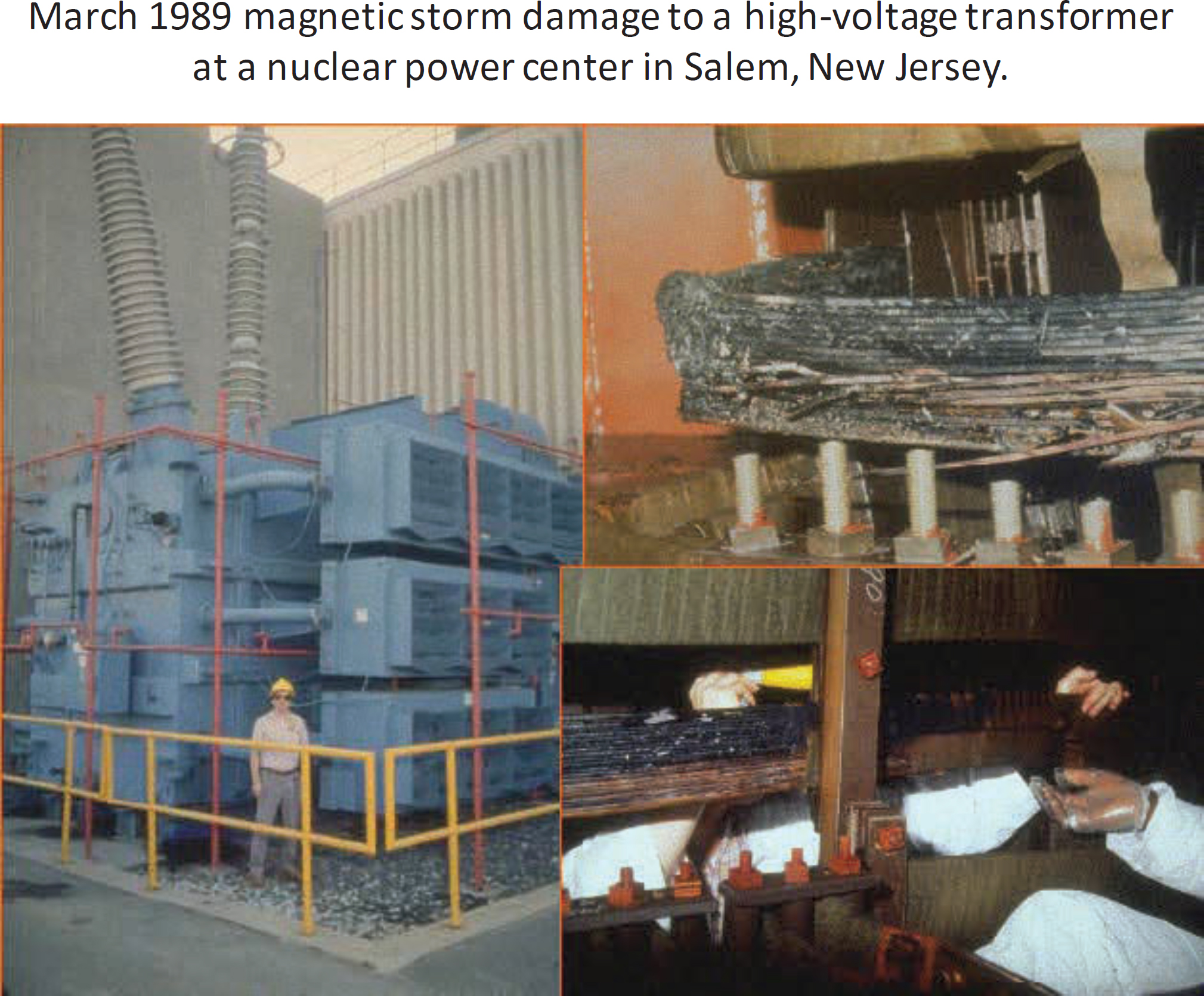
SOURCES: Jeff Love, U.S. Geological Survey, presentation to workshop, April 11, 2022; courtesy of Public Service Electric & Gas (PSE&G) Company New Jersey.
OBSERVATION AND MODELING NEEDS
A panel moderated by committee member Delores Knipp was devoted to the observation and model needs related to ground effects. The panelists were Adam Schultz of Oregon State University, Jenn Gannon of Computational Physics Inc., Jesper Gjerloev of the Applied Physics Laboratory of Johns Hopkins University, Arnaud Chulliat of the University of Colorado and NOAA’s National Centers for Environmental Information, Antti Pulkkinen of NASA’s Goddard Space Flight Center, and Anna Kelbert of USGS.
The focus of this panel was on geomagnetic disturbances (GMDs) and their associated ground effects and GICs. The panelists’ presentations had three overarching themes.
First, more information is needed on extreme space weather conditions: the ranges of possible impacts are not well understood, and there is a lack of understanding of their causes. Second, global simulations, other models, and the combination of observations with models are crucial for developing user-friendly
and comprehensive space weather products—one wiggly line from an instrument is not sufficient for either understanding or predicting space weather. It is important to implement real-time data assimilation into global models (a theme that also emerged from the Data Assimilation panel) as well as to develop higher-level data products for the user community. Experience has shown that community-wide validation activities are crucial for taking models from research to operations. Third, the scarcity of global and continuous real-time measurements is a particularly crucial hindrance of space weather forecasting capabilities. A dense network of geophysical observatories, including ones provided or operated by the private sector, will be required to better understand and provide high-confidence, long-lead-time predictions of GMDs and GICs (see also New Architectures panel discussion in Chapter 6). Continuous maintenance of the ground-based observatories hosting magnetometers, all-sky imagers, or Fabry Perot interferometers requires long-term funding support.
The need for a dense network of ionospheric observations arises from the high spatial and temporal structuring of the aurora and auroral electrojet currents. A panelist gave an example of an intense, localized magnetic field decrease of over 2,200 nT during only 9 minutes recorded at a station in Iceland, which was not observed at all at the surrounding magnetic stations. Furthermore, predicting the GICs driven by the auroral electrojet currents will also require a dense network of observatories that provide high-resolution, three-dimensional conductivity models. As an example, Denver, Colorado, lies within a localized hazard region due to a geological boundary that would not show up in a low-resolution conductivity model (see Figure 4-2). A denser magnetotelluric survey conducted by a denser geomagnetic monitoring network
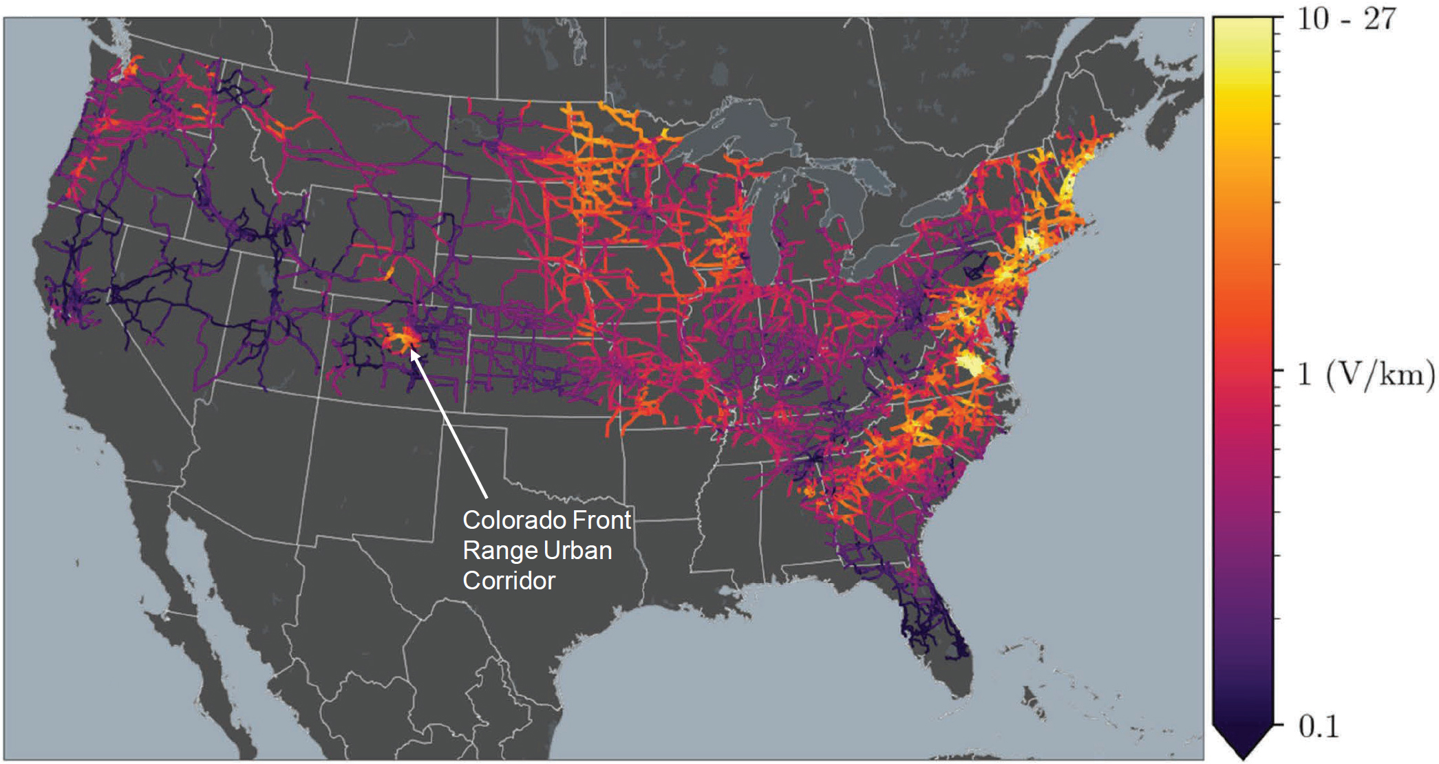
NOTES: Lighter regions (higher electric field) indicate a higher risk. Later data ruled out the localized hazard region around Denver as an artifact of the data.
SOURCES: Anna Kelbert, U.S. Geological Survey, presentation to workshop, April 12, 2022; from G. Lucas, J.J. Love, A. Kelbert, P.A. Bedrosian, and E.J. Rigler, 2020, “A 100-Year Geoelectric Hazard Analysis for the U.S. High-Voltage Power Grid,” Space Weather 18:e2019SW002329, https://doi.org/10.1029/2019SW002329, © 2019 The Authors.
is critical for creating a high-resolution ground conductivity map, which can be turned into a nationwide hazard map. The last step in observations is to have an up-to-date power grid system configuration, which allows computation of the actual GICs in the system.
Additionally, the re-establishment of active connections between scientific and engineering communities will be required to address issues related to GIC modeling and analysis. The North American Electric Reliability Corporation (NERC) GMD task force, one of the main forums attempting to combine and coordinate effort between scientists and engineers for this purpose, was recently reorganized under the Reliability and Security Technical Committee.2 The link between engineers and scientists is crucial for providing rigorous validation of the magnetotelluric data used in GIC applications.
There are many possible ways to create a dense observational network: For data distribution, the SuperMAG international collaboration of ground-based magnetometers hosted at the Applied Physics Laboratory of Johns Hopkins University is a good example of an implementation strategy. For data production, one path forward could be to develop collaborations with the private sector to share the cost of instrument deployment and operations. The private sector in need of space weather information has underused potential to support collection of the relevant information. For example, one group of small businesses provided more than 85 full-time equivalents of support to federal government space weather efforts.
Possible other data sources include those provided by the IRIS (In Situ and Remote Ionospheric Sensing) suite, which may provide a partial solution to developing estimates of the ground effect over the United States. In the future, the Electrojet Zeeman Imaging Explorer (EZIE) mission will map the structure and evolution of the auroral electrojet by flying three CubeSats in a string-of-pearls configuration and making Zeeman splitting measurements.
Another proposed observing solution would entail combining highly accurate, observatory-level, full-field measurements and networks of science-grade variometers with deployment of tens of thousands of amateur-grade variometers. Data from this network combined with observations from space missions and assimilated into a model could provide real-time space weather nowcasts and forecasts. For example, the outreach effort of EZIE will deploy 1,000 magnetometers across the United States, which, while not science-grade, will be sufficient for space weather (science) purposes. This effort illustrates one way to deploy 10,000 magnetometers on a reasonable budget.
Models of the internal geomagnetic field—such as the World Magnetic Model (WMM) and the International Geomagnetic Reference Field (IGRF)—are important, while ionospheric and magnetospheric currents, especially during storms, cause perturbations to the main field. The internal field models have various applications, including orientation and navigation (for airplanes, ships, submarines, spacecraft attitude control, antenna tracking), directional drilling (energy industry), and alternative positioning and navigation (MagNav). Currently, the WMM is specified based on data from low-Earth-orbit satellites (such as the European Space Agency’s SWARM satellite constellation and the Iridium satellite constellation), ground observatories (the international INTERMAGNET network of ground magnetic observatories), and information on the solar wind conditions from L1 (the Deep Space Climate Observatory, or DSCOVR). However, despite the various sources of data, observational gaps remain that limit the accuracy of the geomagnetic field models.
___________________
2 North American Electric Reliability Corporation, “Reliability and Security Technical Committee (RSTC),” https://www.nerc.com/comm/RSTC/Pages/default.aspx, accessed August 10, 2022.


