


Below is the uncorrected machine-read text of this chapter, intended to provide our own search engines and external engines with highly rich, chapter-representative searchable text of each book. Because it is UNCORRECTED material, please consider the following text as a useful but insufficient proxy for the authoritative book pages.
A-1  Cross-Section Decision-Making Tool and User Guide The Cross-Section Decision-Making Tool is provided as an electronic tool. There are two ver- sions of the tool: ⢠Decision-Making Spreadsheet Tool â Reconstruction ⢠Decision-Making Spreadsheet Tool â Resurfacing These spreadsheets may be downloaded by searching the National Academies Press website (nap.nationalacademies.org) for NCHRP Research Report 1036. The rest of this appendix provides a guide for users. Introduction NCHRP Research Report 1036 presents a decision-making framework for roadway designers, planners, and others seeking to identify, compare, evaluate, and justify context-based cross-section reallocations of existing urban and suburban roadway space for multimodal safety, access, and mobility. This report includes a spreadsheet tool to help with decision-making. This spreadsheet tool implements the framework, allowing the practitioner to input real project information and experiment with cross-section design alternatives. For a given design alternative, the tool gives the practitioner the following: ⢠An indication of whether the proposed alternative meets acceptable minimum safe dimensions. ⢠Design options that allow the project to meet minimum safe dimensions and support direct and indirect transportation project goals. ⢠Summary documentation of how well design decisions support project goals. The overall decision-making framework is presented in Figure A-1; the spreadsheet tool provides the practitioner with the tools to proceed from Steps 3 through 6 as shown in the figure. Because the tool provides a direct implementation of the framework presented in NCHRP Research Report 1036, this User Guide uses terms and a process that may be unfamiliar to the practitioner at first. Therefore, it is strongly recommended that practitioners use this tool along- side the referenced sections of NCHRP Research Report 1036. Select the Correct Workbook Tool A separate workbook is provided for each of the two project types: ⢠Repaving projects. Use the Resurfacing workbook for a project where existing curb lines will not be moved as part of a project. This workbook assumes existing curb lines as a design constraint. A P P E N D I X A
A-2 Roadway Cross-Section Reallocation: A Guide ⢠Reconstruction projects. Use the Reconstruction workbook for a project where it is tech- nically feasible to move curb lines. This workbook treats the right-of-way dimension as a constraint. Upon opening the appropriate workbook, the user will find a Table of Contents that lists the workbook tabs (organized by steps). These tabs and steps are described below. Analysis Steps The spreadsheet tool is set up to be a step-wise process with each step on a separate tab in the spreadsheet and with accompanying results that can be printed and used for documentation. Figure A-2 illustrates the tool workflow. ⢠The âStep 1 User Inputâ tab requests the relevant project information from the user. After completing the inputs on this tab, the user may proceed to one of the Step 2 tabs listed below. ⢠The âStep 2A Insufficient Spaceâ tab is used if the total of elements selected and required exceeds the available project cross-section width. This tab provides the user with a few options to amend the proposed cross section so that it will fit within the available width: â Add or remove cross-section elements; â Increase or decrease element widths; and â Adjust the desired roadway speed or volume served. (Lowering either will typically lower width requirements.) ⢠The âStep 2B Sufficient Spaceâ tab is used if the total of elements selected and required does not exceed the available project cross-section width. (Some recommended changes are still likely and possible but, based on minimum safety requirements, sufficient space is available.) The same options as in Step 2A are available to the user here as well. ⢠The âStep 3â sheets provide summaries of the decisions made and the results: â âStep 3A Cross-Section Summaryâ provides a visual before-and-after comparison of road- way cross sections. Figure A-1. Decision-Making Framework.
Cross-Section Decision-Making Tool and User Guide A-3  â âStep 3B Impact Summaryâ provides a summary of cross-section edits the user has made along with a description of the positive or adverse effect of those decisions as they relate to safety, economic, environmental, social, and mode shift outcomes. â âStep 3C Visualizerâ provides a two-page summary of the existing and proposed cross sections. â âStep 3D Int Capacity Summaryâ provides four performance measures to provide a high- level operational result of the proposed cross section. These performance measures give a peak-hour and all-day snapshot of operational results. ⢠The remaining tabs (Calculation A, Calculation B, Calculation C, Calculation D, Calcula- tion E, matrix, matrix2, main lookups, ancillary lookups, and selections) provide support for the workbook calculations and are not for direct use. Input, Output, and Documentation Cell Shading Each spreadsheet is formatted to allow user input and to auto-calculate necessary intermediate steps or outputs. The blue-shaded cells indicate user input is required, and the orange-shaded cells indicate that a value is automatically calculated. Figure A-3 shows example shaded cells with input and output values. Buttons Several buttons are provided in the spreadsheet. These buttons trigger a calculation and updated result within the spreadsheet. In general, whenever input values are updated, the user should subsequently press a button to ensure that the appropriate calculations and checks are re-run. Figure A-4 shows a button. Navigation Instructions Navigation Instructions are provided at the bottom of each tab to direct the user to the next step in the tool (refer to Figure A-5). Print Results Documentation Edit Cross Section to Achieve Minimally Safe Design Input Project Information Step 1 Step 2A Step 2B Step 3 Edit Cross Section to Allocate Additional Space (if applicable) Figure A-2. Tool Workflow. The User proceeds from Step 1 either to Step 2A or 2B, where the cross-section edits will ultimately result in Step 3âprinting results and documentation.
Figure A-3. Spreadsheet Tool Cell Shading. Cells with blue shading are for user input values; cells with orange shading are auto-calculated outputs or intermediate steps. Figure A-4. Buttons are used to ensure calculations and checks are updated. Any time an input is updated, press the corresponding button to refresh necessary calculations.
Cross-Section Decision-Making Tool and User Guide A-5  Step 1 â User Input This tab collects existing cross-section and general project information. The inputs here serve as the basis for the cross-section reallocation recommendations. Step 1.1 â Existing Cross Section In Step 1.1, fill out the table to represent the project roadwayâs existing cross section (see Figure A-6). ⢠Row 17 lists the possible cross-section elements. No changes are necessary here. ⢠In Row 18, enter âYâ if the element is included in the existing cross section or âNâ if the element is not included. ⢠In Row 19, enter the current dimension for each element with a âYâ in feet. The tool will not allow you to enter a dimension if âNâ is indicated for that element in Row 16. ⢠Row 20 will provide the calculated available right-of-way, which represents the projectâs con- straining dimension. Press the yellow button to generate the Right-of-Way in Row 18 (depicted in yellow in Figure A-6). Step 1.2 â Project Information Fill out the table in this step (see Figure A-7). It requests project information, some of which is contextual (used for the documentation) and some of which is subsequently used for calculation and threshold parameters. Take note of the outputs in Rows 37 and 38: ⢠If those numbers are inaccurate, revisit the inputs in Step 1.1 ⢠If those numbers change substantially along your project corridor, consider subdividing the project into sub-corridors with consistent widths and applying this method to each of those sub-corridors. In the second part of the table, fill out the project details (see Table A-1). Figure A-5. Instructions are provided at the bottom of each tab to direct the user to the next step in the tool. Figure A-6. Step 1.1 Inputs.
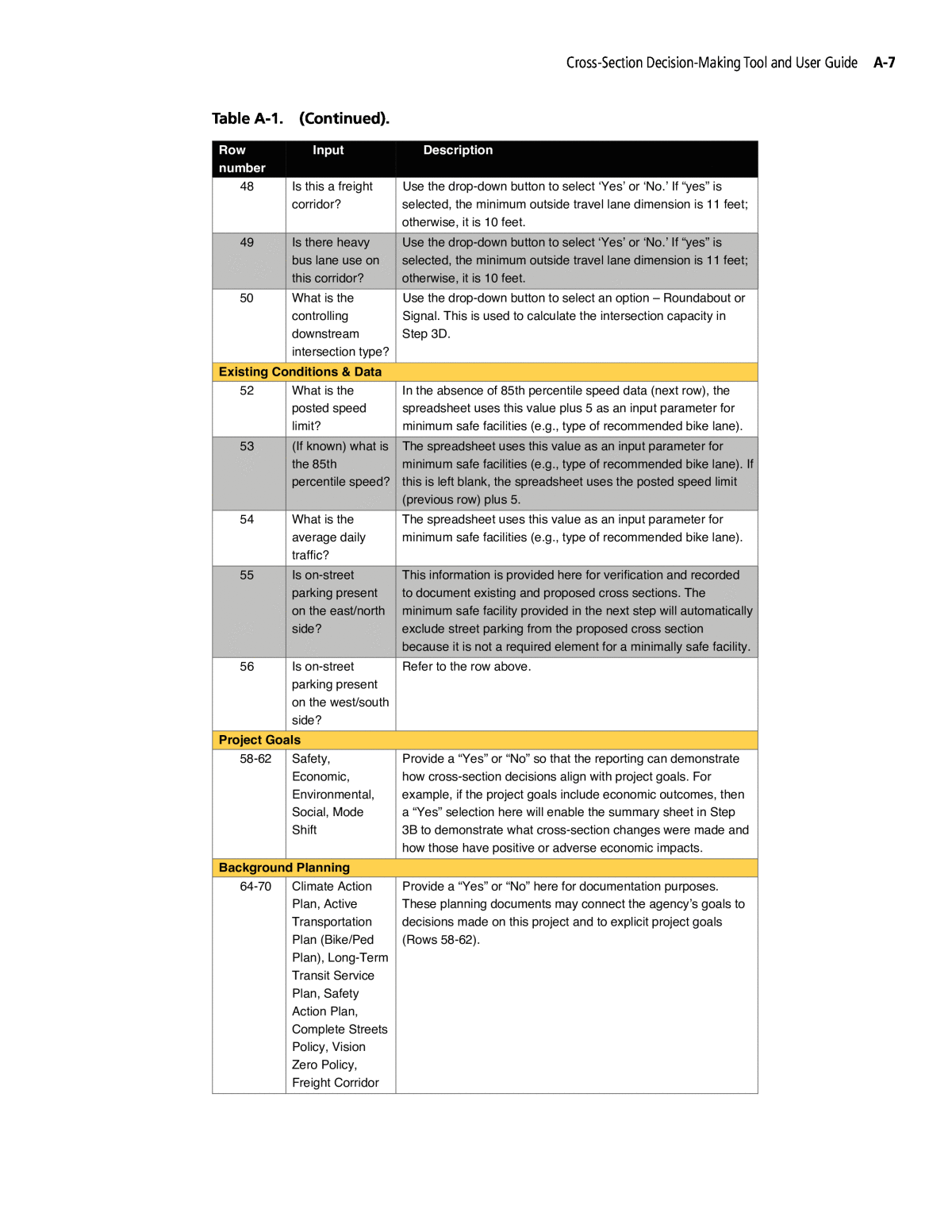
A-6 Roadway Cross-Section Reallocation: A Guide Figure A-7. Step 1.2 Information Table. Row number Input Description Project Details 36 Type of project: Can you move curb lines? Determine whether you can move curb lines. If so, work in the reconstruction workbook. If not, work in the repaving workbook. 37 The curb-to-curb distance in feet Automatically calculated from Step 1.1. If incorrect, adjust cross-section element widths. If those numbers change substantially along your project corridor, consider subdividing the project into sub-corridors with consistent width and applying this method to each of those sub-corridors. 38 The available right-of-way in feet Automatically calculated from Step 1.1. If incorrect, adjust cross-section element widths. If those numbers change substantially along your project corridor, consider subdividing the project into sub-corridors with consistent width and applying this method to each of those sub-corridors. 39 What is the existing land-use Use the drop-down button to select an option. Refer to Guide Chapter 3 for a discussion of applicable land-use contexts. This entry is provided for reference but is not used in tool calculations. 40 What is the planned land-use context? Use the drop-down button to select an option. Refer to Guide Chapter 3 for a discussion of applicable land-use contexts. This entry is used to provide minimum safe recommendations regarding pedestrian facilities. For example, the minimum safe sidewalk widths are different in different planned land-use contexts (see Guide Chapter 7). 41 What is the roadwayâs primary intended function? Use the drop-down button to select an option. Refer to Guide Chapter 5 for a discussion of the roadwayâs primary function. This selection will not affect minimum safe dimension recommendations but will prompt you to consider appropriate design decisions (e.g., speeds, access management). 42 The road directionality Automatically calculated based on Step 1.1. If incorrect, adjust cross-section elements. 43-47 Number and width of cross- section elements Automatically calculated based on Step 1.1. If incorrect, adjust cross-section elements. context? Table A-1. Step 1.2 Inputs and Effects on Workbook Results.
Cross-Section Decision-Making Tool and User Guide A-7Â Â Row number Input Description 49 Is there heavy bus lane use on this corridor? Use the drop-down button to select âYesâ or âNo.â If âyesâ is selected, the minimum outside travel lane dimension is 11 feet; otherwise, it is 10 feet. 50 What is the controlling downstream intersection type? Use the drop-down button to select an option â Roundabout or Signal. This is used to calculate the intersection capacity in Step 3D. Existing Conditions & Data 52 What is the posted speed limit? In the absence of 85th percentile speed data (next row), the spreadsheet uses this value plus 5 as an input parameter for minimum safe facilities (e.g., type of recommended bike lane). 53 (If known) what is the 85th percentile speed? The spreadsheet uses this value as an input parameter for minimum safe facilities (e.g., type of recommended bike lane). If this is left blank, the spreadsheet uses the posted speed limit (previous row) plus 5. 54 What is the average daily traffic? The spreadsheet uses this value as an input parameter for minimum safe facilities (e.g., type of recommended bike lane). 55 Is on-street parking present on the east/north side? This information is provided here for verification and recorded to document existing and proposed cross sections. The minimum safe facility provided in the next step will automatically exclude street parking from the proposed cross section because it is not a required element for a minimally safe facility. 56 Is on-street parking present on the west/south side? Refer to the row above. Project Goals 58-62 Safety, Economic, Environmental, Social, Mode Shift Provide a âYesâ or âNoâ so that the reporting can demonstrate how cross-section decisions align with project goals. For example, if the project goals include economic outcomes, then a âYesâ selection here will enable the summary sheet in Step 3B to demonstrate what cross-section changes were made and how those have positive or adverse economic impacts. Background Planning 64-70 Climate Action Plan, Active Transportation Plan (Bike/Ped Plan), Long-Term Transit Service Plan, Safety Action Plan, Complete Streets Policy, Vision Zero Policy, Freight Corridor Provide a âYesâ or âNoâ here for documentation purposes. These planning documents may connect the agencyâs goals to decisions made on this project and to explicit project goals (Rows 58-62). 48 Is this a freight corridor? Use the drop-down button to select âYesâ or âNo.â If âyesâ is selected, the minimum outside travel lane dimension is 11 feet; otherwise, it is 10 feet. Table A-1. (Continued).
A-8 Roadway Cross-Section Reallocation: A Guide Step 1.3: Step 1 Results Refer to the Step 1.3 results at the bottom of the tab (see Figure A-8). Proceed as directed. ⢠If the instructions say âMinimum dimension not available. Proceed to Step 2A.â, you do not have enough space for the minimum safe dimension. Navigate to the tab âStep 2A Insufficient Spaceâ to continue. ⢠If the instructions say âMinimum dimension available. Proceed to Step 2B.â, you do have enough space for the minimum safe dimension. Navigate to the tab âStep 2B Sufficient Spaceâ to continue. ⢠If the instructions are blank, verify that Steps 1.1 and 1.2 are updated and that the âGenerate ROW Widthâ button has been pressed. Step 2A â Insufficient Space Users arrive at this tab if the available right-of-way is not wide enough to accommodate the roadway cross-section elements and their minimum safe dimensions as recommended by NCHRP Research Report 1036. This tab provides the user with recommendations and options to change project features until the proposed cross section provides minimum safe dimensions and can meet project needs. Step 2A.1 Minimum Safe Dimension The instructions at the top of the tab provide the user with the additional width needed to satisfy project goals. The goal of this tab is to adjust the proposed cross section until the âNeeded Spaceâ (shown as 8 in Figure A-9) is zero. Proceed to the next step to explore options to make up this difference. The base minimum safe cross section is presented here. This is for informational purposes and is not to be edited. An editable version is below in Step 2A.3. Step 2A.2 Possible Cross-Section Edits Select the âGENERATE CROSS SECTION EDITSâ button to display available options for the proposed cross section. These are filtered based on the existing cross section. The table of options (see Figure A-10) indicates the safety, economic, environmental, social, and mode shift impacts of the available options. Figure A-8. Step 1 Results and Navigation Instructions.
Cross-Section Decision-Making Tool and User Guide A-9  Figure A-9. Minimum Cross Section Presented in Tab 2A. Reduce Speeds or Reduce Volumes The reader will note that the Reduce Speeds and Reduce Volumes options shown in Figure A-10 do not display anticipated positive or adverse impacts. Rather, adjusting the desired roadway speed or volume will adjust the required minimum safe dimensions, which will have a feedback loop. This is explained in more detail in Step 2A.3. Step 2A.3 Edit Roadway Characteristics and Cross-Section Elements The âworkingâ proposed cross section is again presented here. The user has two basic categories of possible edits that can help the proposed cross section meet minimum safe requirementsâusers can edit roadway characteristics or they can edit cross- section elements. Edit Roadway Characteristics The tool presents three options for fundamentally altering the roadway that will generally relax width requirements if the minimum safe cross section is not met (see Figure A-11): 1. Reduce the desired roadway speed. Reducing the roadway speed will typically reduce the width required for bike facilities. This relationship is not linear though: consult Chapter 7 of NCHRP Research Report 1036 to understand what the relevant thresholds are where width requirements reduce. 2. Reduce the desired roadway through volumes. Similarly, serving a lower volume of traffic relaxes bike facility width requirements and may reduce the number of vehicle travel lanes the agency deems necessary to include. Consult Chapter 8 of NCHRP Research Report 1036 for a discussion of how an agency could adjust the desired volume and what the effects would be. 3. Identify a safe parallel facility for bikes. By identifying an alternative safe facility for people to bike along, bike facility width requirements are removed from the minimum safe cross- section calculation. Figure A-11 shows how the user can adjust these inputs to alter the cross section.
Figure A-10. Menu of Design Options.
(a) With the existing condition of 30 miles per hour travel speeds and approximately 20,000 vehicles of daily traffic, the minimum bike lane requirements are a 6-foot-wide lane and a 2-foot-wide separation: 8 feet total per direction. Figure A-11. Step 2A.3 Options: Edit Roadway Characteristics. (continued on next page)
(b) With the desired roadway speed changed to 20 miles per hour, the width requirements are instead a 5.5-foot-wide lane and no separation: 5.5 feet total per direction (a reduction of 2.5 feet per direction, or 5 feet total). Figure A-11. (Continued).
(c) With a safe parallel facility identified, there is now no minimum width requirement for bicycle facilities on the project roadway: a reduction of 8 feet per direction (16 feet total). Figure A-11. (Continued).
A-14 Roadway Cross-Section Reallocation: A Guide Edit Cross-Section Elements Alternatively, the user can edit cross-section elements. If the project is close to meeting its minimum required safe widths, then the user may be able to identify some cross-section elements whose widths could be reduced to meet requirements. After changing elements, select the âGENERATE CROSS SECTION WIDTHâ button to calculate whether minimum dimensions are met (see Figure A-12). Note a few details about this step: ⢠The minimum safe dimensions are shown immediately below the cells with desired widths. They will be highlighted in red if the minimum dimension is not met and in green if the minimum dimension is exceeded (see Figure A-12). ⢠The user can identify a two-way bike lane on one side of the street instead of one-way bike lanes on each side. This will obviate the one-way bike lane requirement (but not the separation requirement). The example in Figure A-13 shows this option selected. Step 2A.4 Next Steps Upon selecting the âGENERATE CROSS SECTION WIDTHâ button in Step 2A.3, the instruc- tions here will indicate one of a few options: ⢠Minimum dimension not available. Adjust the cross section until the available space is greater than or equal to 0. Revisit Step 2A.3 to meet the minimum dimension. ⢠Minimum dimension available. Proceed to Step 2B. The minimum dimensions have all been met and some excess right-of-way is still available. Proceed to Step 2B to determine how to allocate the remaining space. ⢠Minimum dimension available. Skip Step 2B. Proceed to results in Steps 3A-3D. The mini- mum dimensions have all been met, and no excess space needs to be allocated. Proceed to Step 3 and print the results! Please note that the results can indicate the minimum dimension has been met, even if the proposed cross section is not meeting some individual element requirements. In other words, the width of the proposed cross section may match the available width, but a required element may be missing. Please check that all required elements are provided. Users may still proceed even if all required elements are not provided, but the results page will request an explanation for why that decision was made. This tab collects existing cross-section and general project information. The inputs here serve as the basis for the cross-section reallocation recommendations. Step 2B â Sufficient Space Step 2B proceeds just like Step 2A. Adjust cross-section elements until the available space in Step 2B.3 is 0 and Step 2B.4 indicates, âMinimum dimension met. Proceed to Tab 3.â (a) not met (b) not met (c) exceeded Figure A-12. Minimum Dimension Guidance.
Figure A-13. Example of edited cross section with two-way bike lane selected.
A-16 Roadway Cross-Section Reallocation: A Guide Step 3: Results The user should print each of the Step 3 tabs listed below to document the decisions made and the transportation and non-transportation effects of the proposed design. The performance measures provided in Step 3B are explained in Chapter 4 of NCHRP Research Report 1036. The intersection capacity analysis presented in Step 3D is described in Chapter 6 of NCHRP Research Report 1036. Step 3A Cross-Section Summary This sheet provides the following summary information: ⢠Basic project details (community, roadway name, project extents and corridor length, roadway primary function, and planned use context) ⢠Visual depiction of existing and proposed cross-section elements ⢠Cross-section width, available space (ROW or curb-to-curb width), and available room given the proposed project Step 3B Impact Summary This sheet provides the basic project details included in Step 3A. It also provides a âyes/noâ indication of project goals and any background planning documents relevant to the project per- taining to safety, economic, environmental, social, and mode shift goals. Below this information, this sheet determines the effects of these five categories related to project changes. For example, if the project adds bike lanes, this page provides a descriptive sum- mary of the potential safety, economic, environmental, social, and mode shift effects of the bike lane addition. The impacts are typically qualitative with âlow/medium/highâ and ânear-term/ long-termâ descriptors to describe the magnitude and timeline of effects. Where documented quantitative effects are available (e.g., crash reduction factors associated with treatments), these are included. Step 3C Visualizer This sheet provides a visual depiction of the existing and proposed cross-section elements. It is scaled to represent the width of selected elements and the available ROW â in other words, unlike Step 3A, it provides a scaled visual representation of existing and proposed elements. Step 3D Int Capacity Summary This sheet provides four measures that account for time-of-day effects and expand on the notion of whether a project âworksâ operationally beyond just the peak period. These planning- level measures build on the methods provided in Part 1, Section G of NCHRP Report 825: Plan- ning and Preliminary Engineering Applications Guide to the Highway Capacity Manual. The sheet creates a daily demand profile and calculates four performance measures: 1. Hourly demand-to-capacity (d/c) ratio. This measure allows the analyst to assess whether demand exceeds capacity (d/c > 1) at any time during the day and, if so, for how long. 2. A 16-hour efficiency metric. This measure calculates the percentage of the hours between 5:00 a.m. and 9:00 p.m. during which the roadway exceeds capacity. This metric excludes the remaining 8 hours of the day, during which a roadway would be unlikely to approach or exceed capacity. An efficiency score of 100% indicates that the roadway is over capacity for
Cross-Section Decision-Making Tool and User Guide A-17  every hour in the analysis range; 75% would indicate the roadway is over capacity for 12 of 16 hours; and so forth. 3. A 16-hour excess capacity metric. This measure indicates the capacity provided for but unused during that 16-hour period. This number ranges from 0 to 16, with 16 indicating that the roadway is completely empty during the 16-hour period (i.e., there are 16 full hours of excess capacity), 0 indicating the roadway is at or above capacity completely, and values between indicating the extent to which the roadway is providing capacity above demand throughout the day. 4. Total hours below capacity: the number of hours (out of 24) during which the roadway is operating below capacity (d/c < 1). The evaluation takes the following values as inputs: AADT, number of lanes, D factor, K factor, and traffic control at the critical downstream intersection. The critical downstream intersection can be defined as the intersection on the corridor with the largest volume of cross-street traffic. The sheet creates an all-day demand profile based on AADT and peak-hour and peak-direction input assumptions. For the existing cross section, press the yellow button to calculate the controlling downstream intersection and input the default D factor and K factor. You may edit these cells if you know the D factor or K factor or choose to use another downstream intersection type. The downstream intersection types are as follows: ⢠Signal â Two Lane: One through lane in each direction. Assumes a left-turn pocket with adequate queue storage and a protected left-turn phase but no separate right-turn lane. ⢠Signal â Three Lane: One through lane in each direction and a continuous two-way left-turn lane. Assumes a left-turn pocket with adequate queue storage and a protected left-turn phase but no separate right-turn lane. ⢠Signal â Four Lane: Two lanes in each direction. Assumes a left-turn pocket with adequate queue storage and a protected left-turn phase but no separate right-turn lane. ⢠Roundabout: Roundabout assumed (single or multilane depending on the roadway cross- section width). For one-way streets, the selection applies the number of through lanes consistent with the descriptions above. The method likely underestimates the capacity for one-way applications. For a more detailed analysis, the reader is advised to consult the Highway Capacity Manual or NCHRP Report 825: Planning and Preliminary Applications Guide to the HCM. For the proposed cross section, press the yellow button to calculate the ADT and controlling downstream intersection and input the default D factor and K factor. You may edit these cells if you know the D factor or K factor, choose to use another downstream intersection type, or have a different proposed ADT number.
