


Below is the uncorrected machine-read text of this chapter, intended to provide our own search engines and external engines with highly rich, chapter-representative searchable text of each book. Because it is UNCORRECTED material, please consider the following text as a useful but insufficient proxy for the authoritative book pages.
9-1 Chapter 9 Surveys, Monitoring Strategies, and Habitat Assessments 9.1 Introduction Assessments of pollinator communities and metrics for roadside pollinator habitat can provide valuable information for departments of transportation (DOTs) looking to implement voluntary pollinator conservation goals. Surveys for listed and imperiled species in project areas can help guide revegetation choices and federal Endangered Species Act (ESA) compliance options. Monitoring over time can be used to determine if conservation goals are being met. Measuring the response of vegetation or a pollinator community will help determine whether changes implemented to improve roadside vegetation for pollinators have been effective and met the objectives. Monitoring is also a key component of adaptive management; monitoring data can be used to determine if and what corrective actions may be needed. In addition to helping to effectively manage and maintain a current project, monitoring also can inform the implementation of future projects or management activities. The term monitoring is used here to specifically describe data from repeated sampling that can be used to detect changes, such as to evaluate the effectiveness of revegetation or maintenance practices over time (e.g., Elzinga and Salzer 1998). Monitoring is also sometimes used as a general term to describe other data collecting activities, such as surveys or inventories. An inventory aims to catalog all species or a subset of species within an area, whereas surveys are samples of a particular species or a representative portion of an area (e.g., Pokorny et al. 2006). In this document, the term survey describes sampling to determine the presence or absence of a particular imperiled pollinator species at a given site. Surveys are important for DOTs seeking to determine if a listed or imperiled species occurs on a particular right-of-way in order to take appropriate action for ESA compliance. This chapter includes protocols that can be used to survey for and detect imperiled species of pollinators, specifically a protocol for imperiled butterflies and a protocol for bumble bees, as well as a monitoring protocol that can be used to measure general bee and butterfly community responses to changes. A rapid and comprehensive roadside habitat assessment guide is also included, along with guidance for monitoring roadside vegetation as pollinator habitat. It may take some time and familiarity with these different protocols to determine which data collection method is best for a projectâs objectives. 9.2 Pollinator Surveys and Monitoring The protocols presented in this section provide instructions for monitoring the general pollinator community (bees and butterflies), as well as ways to survey and monitor bumble bees and imperiled butterflies. The monitoring protocols involve collecting data on abundance, which can be useful to detect changes over time. However, if your target species is difficult to detect or occurs in low densities, it may be preferable to survey for occupancy
Chapter 9. Surveys, Monitoring Strategies, and Habitat Assessments 9-2 rather than measure abundance (Taron and Ries 2015). The monitoring protocols can be used to assess roadside habitat in a number of ways, such as determining the following. 1. Whether revegetation efforts have increased pollinator richness and abundance (by including nearby non-revegetated roadsides in samples as reference sites) 2. If pollinator richness and abundance change over time 3. Habitat quality 4. The effects of different roadside management strategies or seed mixes on pollinators 5. Survival rates for specific imperiled species The survey protocols can be used to determine the presence or absence of a target species, also known as occupancy, which is a procedure used to understand if a species is present at a particular site. Whether surveying to determine if a species occurs on a right-of-way or monitoring a population or community of pollinators to assess change over time (e.g., before and after a construction project), there are several important considerations: ⢠Know the life history and habitat needs of your target species. Understanding host plant needs, known habitat, and flight windows of adults will help you have the best chances to find your target species (see Chapter 3, Imperiled Pollinator Profiles, to find this information for some at-risk pollinators in your region). For example, it is very helpful to be able to narrow down where the Uncompahgre fritillary might be found by knowing that it only feeds on snow willow that has a lot of water throughout the summer (to make it more palatable) and so only lives under year-round snow fields on the north side of peaks above 13,000 feet in southern Colorado. ⢠Surveying for adult pollinators is most practical. It may be impractical to find and/or difficult to recognize other life stages of pollinators and it may be harmful to them (e.g., searching for a bumble bee nest or butterfly eggs laid singly within a grass clump). Adult flight periods are also more well-known than activity of other stages. ⢠It can be challenging to identify pollinators. For example, most native bees can only be identified to species by examining pinned specimens under a microscope and obtaining confirmation from experts. Standard pollinator monitoring techniques typically employ destructive sampling, with specimens collected using nets or traps, pinned, and then identified by a taxonomist. While these collection techniques provide the most robust data, they can be labor intensive, time consuming, and expensiveâand result in loss of pollinators. Using non-lethal methods when possible should be a priority (Tepedino and Portman 2021). Collecting observational data on pollinators is an economical and effective alternative to monitoring pollinators. However, training and practice are needed to recognize members of different groups of pollinators, commonly occurring local species, and imperiled species. Oklahoma State University operates research areas on ODOT rights-of-way to study the effects of mowing and other maintenance practices on roadside vegetation and on monarch butterflies. The survey and monitoring methods outlined in this chapter can be used on roadsides to provide information on how practices are affecting pollinator communities. Photo Credit: Vonceil Harmon
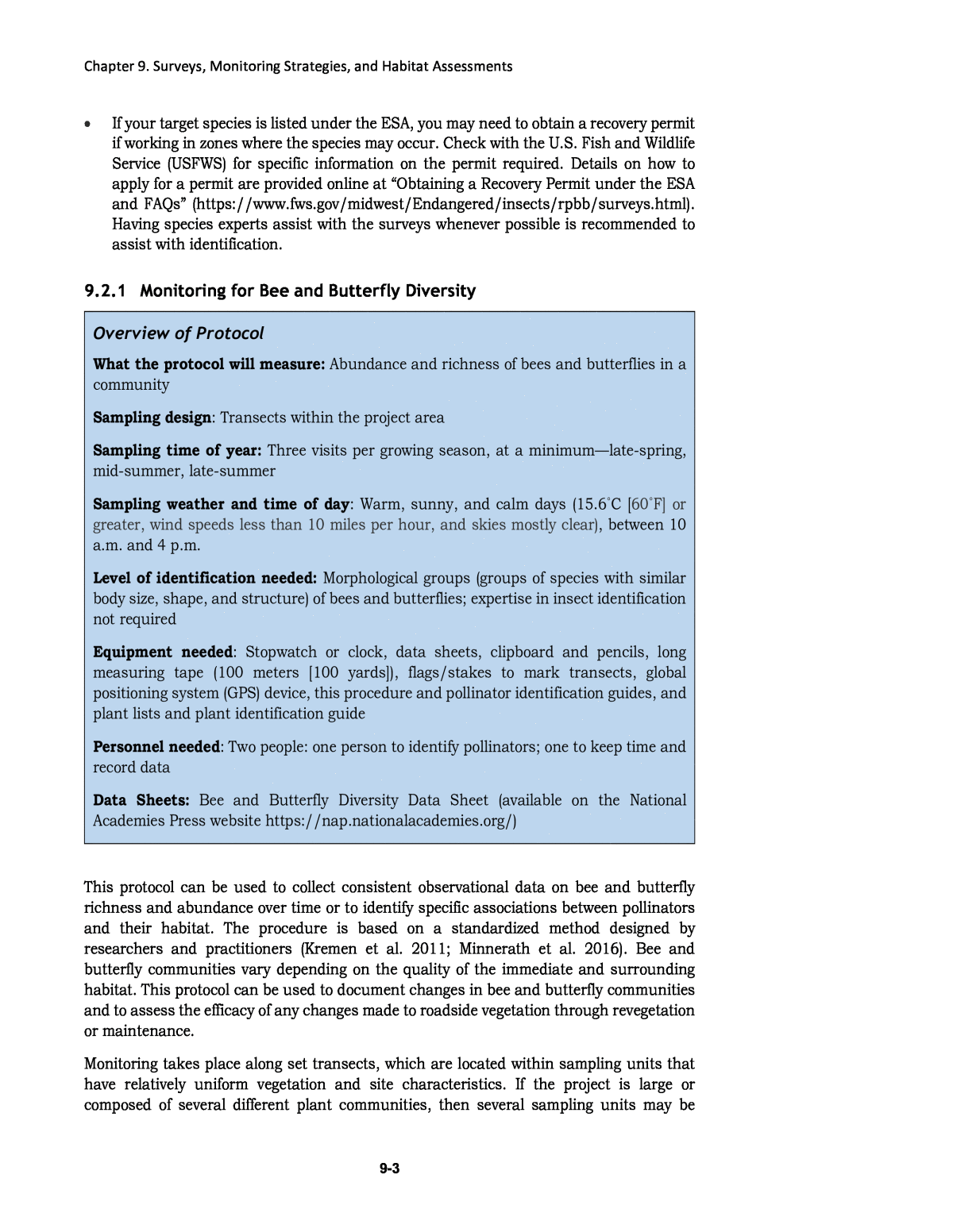
Chapter 9. Surveys, Monitoring Strategies, and Habitat Assessments 9-3 ⢠If your target species is listed under the ESA, you may need to obtain a recovery permit if working in zones where the species may occur. Check with the U.S. Fish and Wildlife Service (USFWS) for specific information on the permit required. Details on how to apply for a permit are provided online at âObtaining a Recovery Permit under the ESA and FAQsâ (https://www.fws.gov/midwest/Endangered/insects/rpbb/surveys.html). Having species experts assist with the surveys whenever possible is recommended to assist with identification. 9.2.1 Monitoring for Bee and Butterfly Diversity Overview of Protocol What the protocol will measure: Abundance and richness of bees and butterflies in a community Sampling design: Transects within the project area Sampling time of year: Three visits per growing season, at a minimumâlate-spring, mid-summer, late-summer Sampling weather and time of day: Warm, sunny, and calm days (15.6ËC [60ËF] or greater, wind speeds less than 10 miles per hour, and skies mostly clear), between 10 a.m. and 4 p.m. Level of identification needed: Morphological groups (groups of species with similar body size, shape, and structure) of bees and butterflies; expertise in insect identification not required Equipment needed: Stopwatch or clock, data sheets, clipboard and pencils, long measuring tape (100 meters [100 yards]), flags/stakes to mark transects, global positioning system (GPS) device, this procedure and pollinator identification guides, and plant lists and plant identification guide Personnel needed: Two people: one person to identify pollinators; one to keep time and record data Data Sheets: Bee and Butterfly Diversity Data Sheet (available on the National Academies Press website https://nap.nationalacademies.org/) This protocol can be used to collect consistent observational data on bee and butterfly richness and abundance over time or to identify specific associations between pollinators and their habitat. The procedure is based on a standardized method designed by researchers and practitioners (Kremen et al. 2011; Minnerath et al. 2016). Bee and butterfly communities vary depending on the quality of the immediate and surrounding habitat. This protocol can be used to document changes in bee and butterfly communities and to assess the efficacy of any changes made to roadside vegetation through revegetation or maintenance. Monitoring takes place along set transects, which are located within sampling units that have relatively uniform vegetation and site characteristics. If the project is large or composed of several different plant communities, then several sampling units may be
Chapter 9. Surveys, Monitoring Strategies, and Habitat Assessments 9-4 delineated and sampled separately. The number of transects placed in a sampling unit depends on the size of the unit and topographic relief: ⢠<0.8 hectare (<2 acres) â no relief: establish one 120-meter (400-foot) transect through the middle of the area outside of the mowed strip in the recovery area, running parallel to the road ⢠â¤0.8 hectare (â¤2 acres) â with relief: orient multiple transects of equal length that add up to a total of 120 meters (400 feet) running perpendicular to road (for ease of walking the transect) and spaced apart evenly (e.g., 3 meters [10 feet]) ⢠â¥0.8 hectare (â¥2 acres) â no relief: establish three 120-meter (400-foot) transects through the middle of the area outside of the mowed strip in the recovery area, running parallel to the road separated evenly ⢠â¥0.8 hectare (â¥2 acres) â with relief: orient multiple transects of equal length that add up to a total of 365 meters (1,200 feet) running perpendicular to road (for ease of walking the transect) and spaced apart evenly If making comparisons between sites, it is best to keep the individual transect length and the distances between transects constant. For sites that are greater than 0.8 hectare (2 acres) in size, three 120-meter-long (400-foot-long) transects are used that are spaced evenly throughout the site. Transects are located in full sun where possible (or notations are made on data sheets when in shade) because pollinator activity declines in shade. Record GPS coordinates to allow others to monitor the area in the future. Monitoring is conducted at least three times a growing season, ideally monthly. This is because many bee and butterfly species fly for a limited number of weeks each growing season, and the communities may differ greatly between samplings. It is important to be consistent from year to year in the frequency and approximate timing of monitoring so that comparisons between years can be made. Weather conditions strongly influence bee and butterfly behavior. Bees avoid activity on cold, windy, or overcast days, so monitoring is optimal when sampling on days with air temperatures over 15.6ËC [60ËF], wind speeds less than 10 miles per hour, and skies mostly clear. Standardizing the time of day that sampling occurs is also important. Pollinators are most active between 10 a.m. and 4 p.m. These procedures can be implemented by observers working on their own, but it is easier when working in pairs, with one person to act as an observer and the other to record observations and data. It is also easiest to conduct observations of bees and butterflies on separate walks of the transects to help focus identification. This monitoring approach is geared toward users who are not experts in insect identification; however, training and practice with identifying bee and butterfly groups used in this protocol will provide more accurate monitoring. The Bee and Butterfly Diversity Data Sheet is available on the National Academies Press website (https://nap.nationalacademies.org/). When making observations of floral visitors within a transect: ⢠Insects should be observed carefully and only identified to a level at which the surveyor is confident.
Chapter 9. Surveys, Monitoring Strategies, and Habitat Assessments 9-5 ⢠Insects visiting flowers should not be disturbed before an observation can be made. The surveyor should walk slowly and avoid sudden movements. Insects will respond to shadows passing overhead, so the surveyor should walk so as not to cast a shadow where observations are to be made. Bee Monitoring The transect is walked at a steady pace, such as 3 meters (10 feet) per minute; expect each 120-meter (400-foot) transect to take about 40 minutes. The surveyor walks slowly, looking for flower visitors within 1 meter (3.3 feet) to each side of the transect. Surveyors do not need to spend more than a couple of observational minutes at any flower or group of flowers. The time spent walking transects should be consistent so that the data is collected with the same level of effort to allow for comparisons between samples over time. For each flower visitor observed, the surveyor should record: the identification of the bee to the level the observer is comfortable, the number of times an individual of this bee was seen during the monitoring period, and the flower species on which the bee was observed. If using a two-person team, one can dictate the bees and flowers, while the other records the data. Only bees that are on the reproductive parts of the flower are identified and recorded. Bees sitting on petals, leaves, or in flight are not recorded. When a bee is visiting a flower, the bee is observed and identified using the recognition guide. See Appendix C, Bee and Bee Group Recognition, for the bee recognition guide. Note that honey bee abundance cannot provide a measure of the value of habitat because the number of individual honey bees visiting habitat is determined by the number of managed hives in the vicinity. The recorder reports these observations on a data sheet, which will be available here (this will link to a data sheet available on Web Resources project webpage). It can also be helpful to note other floral visitors beyond bees, and the species of the flower on which the bees are observed. If more than one floral visitor is observed on a single flower, the number of visitors is noted first and then they are identified. After the bee data is collected, each additional flower species that is in bloom but did not have floral visitors during the survey is noted. At the end of each transect, the recorder tallies the number of pollinators, the travel time, time of day, the length of transect, transect number, and weather conditions. If other monitoring procedures (e.g., Soil Cover, Species Cover, and Species Presence) are to be conducted, the team returns to the beginning of the transect and conducts these procedures. Records of roadside sampling areas also include the site name, sampling area designation, date, name of the sampler, weather conditions, time of visit to the site, and any pertinent notes about the site. It is also valuable to record the plants that are blooming along the transect at the time of the survey, as well as to collect data on the floral associations of the bees at the site. Bees are recorded when they are observed visiting flowers along the transect. Photo Credit: Sara Morris/The Xerces Society
Chapter 9. Surveys, Monitoring Strategies, and Habitat Assessments 9-6 If multiple roadside sampling areas are surveyed, the differences observed in native bee abundance reflect differences in habitat quality among sites. Native bee counts can be used to rank the quality of sites or the quality of seed mixes, or can be used over time to assess changes at a site. Butterfly Monitoring This monitoring procedure is based on the standardized Pollard Walk (Pollard et al. 1975) and can be used to collect observational data on the abundance and richness of butterflies. The objective of this procedure is not to count all butterflies present at the entire site or within the habitat being monitored, but to count those individuals that occur in, or move through, the transectâs sampling area while the surveyor is walking at a steady pace of 3 meters (10 feet) per minute. The surveyor identifies and counts butterflies on flowers or in flight if they occur within approximately 4.5 meters (15 feet) on each side of the transect or overhead of the surveyor. Butterflies that fly in from behind the surveyor are not counted to avoid counting the same individual twice. Butterflies are identified to the level most comfortable to the surveyor (refer to butterfly identification guide) and recorded as whether the butterfly was observed in flight or nectaring on a flower. If the butterfly is nectaring, it can be helpful to record the species of the plant on which the butterfly was feeding. Considerations include the following: ⢠It is important to be consistent, using the same level of effort with each time transect. ⢠The time spent walking the transect is recorded each time. ⢠Records of observations should include the site name, date, name of the sampler, weather conditions, time of visit to the site, and any pertinent notes about the site. ⢠It is also valuable to record the plants that are blooming along the transect at the time of the survey, as well as to collect data on the floral associations of the pollinators at the site. See Appendix D, Butterfly and Butterfly Group Recognition, for guidance on recognizing groups of butterflies. Data Analysis for Community Monitoring To draw meaningful conclusions about the effects of roadside habitat on bees and butterflies, data needs to be collected consistently over time in the same areas. To determine changes in abundance over time, the number of individuals observed during each monitoring event is tallied (transects can be combined if multiple transects are sampled). These numbers can be averaged for each year (e.g., the results from late-spring, mid-summer, and late-summer can be averaged) and plotted on a graph or table to show changes between years. The numbers of individuals can also be totaled for each monitoring event and evaluated separately. Honey bee counts may be excluded in many analyses because the placement of hives and human intervention influences their abundance. Butterflies can be monitored using Pollard Walks, where butterflies are counted along a transect. Photo Credit: Angela Laws/The Xerces Society
Chapter 9. Surveys, Monitoring Strategies, and Habitat Assessments 9-7 To calculate species richness for each sampling period or each year, the total number of bee groups and butterfly groups observed is tallied. Richness can then be plotted to record changes over time, whether comparing the average or total number of groups observed across all sample periods for each year, or comparing the total number of groups observed during a certain sampling period from year to year. As noted before, pollinator populations vary over the course of the growing season and from year to year, so it is important to schedule monitoring accordingly. Pollinator populations also vary annually, increasing as plants become established and mature, which may take several years after seeding or planting. For this reason, monitoring is conducted for several years after the project has been completed, ideally 3â5 years. The longer the period over which sites are surveyed, the more meaningful the results. 9.2.2 Imperiled Butterfly and Moth Protocol Overview of Procedure What the procedure will measure: Butterfly and/or moth presence or absence; can be used over time to estimate population size Sampling design: Transects within the project area Sampling time of year: Survey once or more within the window of the documented flight period of your target species (see species-specific details in Chapter 3) Sampling weather and time of day: Warm, sunny, and calm days (15.6ËC [60ËF] or greater, wind speeds less than 10 miles per hour, and skies mostly clear), between 10 a.m. and 4 p.m. Level of identification needed: Identify species of butterflies or moths Equipment recommended: Stopwatch or clock, data sheets, clipboard and pencils, aerial insect net, binoculars (if applicable), GPS device, field identification guides, glassine envelopes, long measuring tape (100 meters [110 yards]), flags/stakes to mark transects, and federal or state permits (if applicable) Personnel needed: Can be conducted by a single person, but easier with two Data Sheets: Imperiled Butterfly Data Sheet (available on the National Academies Press website [https://nap.nationalacademies.org/]). Begin by identifying areas of potentially suitable habitat for your target species, areas with adequate larval food plants, nectar sources, and habitat to sustain a population. Many species have highly specific larval feeding preferences (e.g., limited to one or a few related plant species whose defenses they have evolved to overcome), while other species exhibit more general feeding patterns, with representatives from multiple plant families in their diet. For species-specific dietary preferences and habitat information, see the species profiles in Chapter 3. Survey areas of suitable habitat or known occupied sites for your target species during adult flight periods (also in the species profiles in Chapter 3). Be aware that flight times may vary due to weather conditions in the spring and early summer,
Chapter 9. Surveys, Monitoring Strategies, and Habitat Assessments 9-8 and will vary with elevation when planning the survey period. If there are local species experts in the region, consult them on the optimal survey timing. Surveys need to be conducted with at least one butterfly expert present; an expert is someone who can definitively identify the target species. Non-expert surveyors can be paired with experts, but limit the number of surveyors to three in total at small sites (<1.2 hectares [<3 acres]) to reduce trampling of vegetation. Upon arriving at each potential site, the following survey protocol can be used to determine the presence or absence of species: 1. Approach the site and scan for any butterfly activity, as well as suitable habitat. Butterflies are predominantly encountered nectaring at flowers, in flight, basking on a warm rock or the ground, visiting host plants, or puddling (sipping water rich in mineral salts from a puddle, moist ground, or dung). Walk through the site slowly (about 100 meters [110 yards] per 5 minutes), looking back and forth on either side, approximately 6â9 meters (20â30 feet) out. Try to walk in a path such that you cover the entire site with this visual fieldâyour route can twist and turnâor at least all of the areas of suitable habitat. If you must leave the transect path (e.g., to look at a particular butterfly), do your best to return to the specific place where you left your path when you resume walking/searching through the site. 2. When a suspected target species is encountered, the optimum method is to net the butterfly to confirm its identification. Adults are collected using a long-handled aerial sweep net with mesh light enough to see the specimen through the net. When stalking perched individuals, approach slowly from behind. When chasing, swing from behind and be prepared to pursue the insect. A good method is to stand to the side of a butterflyâs flight path and swing out as it passes. After capture, quickly flip the top of the net bag over to close the mouth and prevent the butterfly from escaping. Once netted, most insects tend to fly upward, so hold the narrow end of the net bag up (with the mouth downward) and reach in from below when retrieving the butterfly. You will need permits to catch listed butterflies. Having experts assist with the surveys is recommended to aid identification and with collection, to minimize potential injuries to the butterflies. 3. Binoculars and cameras may also be used to view wing patterns of perched butterflies, in lieu of catching the butterfly. Because most butterflies can be identified by macroscopic characters, high-quality photographs will likely provide sufficient evidence of species occurrences at a site, and those of lesser quality may at least be valuable in directing further study to an area. Use a camera with a good zoom or macro lens and focus on the aspects of the body that are the most critical to species determination (i.e., dorsal [upper] and ventral [lower] patterns of the wings) (Pyle 2002). When possible, take several photographs of potential target species showing a clear view of the ventral and dorsal sides of the wings at each survey area where they are observed. This method may be preferred to catching the butterflies, especially for listed species. 4. If needed, collect and chill individual butterflies within a vial or envelope, placing the container in a cooler with ice, buffering the specimen from the ice with a towel. After 5â10 minutes of chilling, place the butterfly on a flat surface with high contrast to photograph it from several angles, making sure to get photos of the dorsal view (back
Chapter 9. Surveys, Monitoring Strategies, and Habitat Assessments 9-9 side) forewings and hindwings, the ventral view (the underside of the wings), and the head and antennae. After photographing, move the butterfly to a sunny spot and allow it to warm up and fly away. 5. Fill out all of the site information on the datasheet, including site name, survey date and time, elevation, aspect, legal location, latitude and longitude coordinates of the site, weather conditions, and a thorough description of habitat, including vegetation types, vegetation canopy cover, suspected or documented host plant species, landscape contours (including direction and angle of slopes), and insect behavior (e.g., âpuddlingâ). Record the number of target species observed, as well as butterfly behavior, plant species used for nectaring or egg-laying, and survey notes. Photographs of habitat are also useful. If looking to estimate population size and monitor changes over time, abundance can be measured by using either the Pollard Walk method (see the butterfly monitoring protocol above for details on applying a Pollard Walk to roadsides), in which the recorder walks only along a precisely marked transect, or the checklist method, in which the recorder is free to wander at will in active search of productive habitats and nectar sites (Royer et al. 1998). A test of differences in effectiveness between these two methods at seven sites found that checklist searching produced significantly more butterfly detections per hour than Pollard Walks at all sites, but the overall number of species detected per hour did not differ significantly between methods (Royer et al. 1998). Checklist surveys are a more efficient means for initial surveys and generating species lists at a site, whereas the Pollard Walk is more practical and statistically manageable for long-term monitoring. Recorded information needs to include start and end times, weather, species, sex, and behavior (e.g., âfemale nectaring on flowers of Lathyrus nevadensisâ). For detailed summaries of approaches to butterfly monitoring, see Taron and Ries (2015) and Haddad et al. (2008).
Chapter 9. Surveys, Monitoring Strategies, and Habitat Assessments 9-10 9.2.3 Bumble Bee Protocol Overview of Procedure What the procedure will measure: Bumble bee presence or absence, species diversity Sampling design: Transects within the project area Sampling time of year: Survey once or more within the window of the documented flight period of your target species (see species-specific details in Chapter 3); early June to early August often is the best chance to detect most species and reduce impacts to queens (which typically fly earlier in the season) Sampling weather and time of day: Warm, sunny, and calm days (15.6ËC [60ËF] or greater, wind speeds less than 10 miles per hour, and skies partly cloudy to clear), between 10 a.m. and 4 p.m. Level of identification needed: Distinguish bumble bees from other flower visitors; distinguish species of bumble bees to the best of your ability Equipment recommended: Stopwatch or clock, data sheets, clipboard and pencils, aerial insect net, clear vials or small Ziploc plastic bags, camera, cooler with ice, long measuring tape (100 meters [110 yards]), flags/stakes to mark transects, GPS device, field identification guide or Bumble Bee Watch phone app, and federal or state permits (if applicable) Personnel needed: Can be conducted by a single person, but easier with two Data Sheets: Bumble Bee Data Sheet (available on the National Academies Press website [https://nap.nationalacademies.org/]) Begin by identifying areas of potentially suitable habitat for your target speciesâareas with adequate flowering plants and potential nesting habitat to sustain a population. See the species profiles in Chapter 3 for nesting habits of your target bumble bee species and known sources of pollen and nectar. Survey areas of suitable habitat or known occupied sites for your target species during adult flight periods (see species profiles in Chapter 3). Be aware that flight times may vary due to weather conditions in the spring and early summer when planning the survey period, and that the phenology of queens, workers, and male bumble bees change throughout the growing season. Take in-field habitat assessments, collecting the basic habitat information included on the bumble bee data sheet (available on the National Academies Press website [https://nap.nationalacademies.org/].) and taking representative photographs of the survey area, including high- and low-quality habitat. Record the coordinates of the corners of the surveyed area using a GPS device and estimate the size of the area surveyed. Note the flowers on which any bumble bees are Bumble bees should be sampled in the summer on sunny, warm days with low wind. Photo Credit: Rich Hatfield/The Xerces Society
Chapter 9. Surveys, Monitoring Strategies, and Habitat Assessments 9-11 captured or photographed. If unsure of the plant species when in the field, make sure to take photos of the flower, stem, and leaves for identification later. Survey Protocol to Detect a Species Protocol Set-up Conduct surveys during three evenly spaced sampling periods across the flight period of your target species. Early June to early August often is the best chance to detect most species and also reduces impacts on queens, which typically fly earlier in the season (negative impacts on queens are more likely to affect populations than impacts on workers). Identify your survey area, and spend 1 hour sampling within the highest quality habitat of that area; if sampling a large area (>0.8 hectare [>2 acres]), sample 1 hour per 0.8 hectare (2 acres) or have multiple people sampling simultaneously. Preferentially capture the bumble bees that match or are similar to the description of your target species, capturing individuals one at a time using a net. Bumble Bee Sampling To survey bumble bees, you will net bumble bees off of flowers or catch them in a vial, capturing all bumble bees observed, one at a time. If the target species is listed, obtain the proper permit to be able to handle the bees, or you can opt to photograph the bees as they forage rather than handling them (if photographing, take a series of photos for each individual to properly document the beeâs characteristics, including the face, side, and back; see Appendix E, Bumble Bee Recognition and Photography, for more tips). Identify and record the species and number of individuals if an expert is present (one who can definitively identify the target species). Otherwise, chill the bees within their bag or vial in an ice-filled cooler in order to take photographs of each individual. Assign a number to each vial and write the same number on your data sheet to keep each bee connected to its flowering plant (or you can place a petal from the flower within the vial to help you later connect the flower to the bee). Continue searching for bees until you have reached the end of your transect, when you should stop the timer, note the end of your survey, and begin to photograph your chilled bees. Placing the bees in a cooler will slow them down (bees are ectothermic), making photographs from multiple angles much easier to take. Take care not to leave bees in the cooler longer than 1 hour or to leave bees within vials in direct sunlight for longer than a few minutes. Bees may take a few minutes to warm up enough to fly away after being released from their vial. To photograph a chilled bee, remove it from the vial and place it on a flat surface with a solid background of high contrast (e.g., pale colored paper). Use a digital camera or a smartphone to capture different angles of the bee useful in identification. See Appendix E for more details on photographing bumble bees that have been chilled or that are foraging on flowers. Link each photograph to a particular individual for tracking. Photographs can be submitted to Bumble Bee Watch for confirmation of identifications by experts. See https://www.bumblebeewatch.org/ or download the app (e.g., https://apps.apple.com/us/app/bumble-bee-watch/id1112626392).
Chapter 9. Surveys, Monitoring Strategies, and Habitat Assessments 9-12 Monitoring Protocol This protocol can be used to detect trends in known populations by using the following protocol multiple times per year for multiple years. This protocol is similar to the survey protocol, except that sampling is conducted along permanent transects. Monitoring needs to have a standard level of effort across sampling sessions. Protocol Set-up Establish at least one transect of 120 meters (400 feet) (meandering transects are fine) that covers the highest quality habitat of the site; establish multiple transects as needed to adequately cover the siteâs habitat. Use a GPS unit to track transects, or flag the transects so you can easily revisit them over the course of the season (or multiple years). Plan to spend about 15 minutes surveying per 30 meters (100 feet), capturing bees within 1 meter (3.3 feet) of each side of the transect. Use more time if needed, and record the time spent per transect each visit. Sample transects three separate times across the growing season. Follow protocols described in the Bumble Bee Sampling section above to document bumble bees observed along established transects. 9.3 Habitat Assessment and Vegetation Monitoring 9.3.1 Roadside Pollinator Habitat Assessment Existing roadside vegetation can be evaluated using a pollinator habitat evaluation guide. The Roadside Pollinator Habitat Assessment Tools, available on the National Academies Press website [nap.nationalacademies.org], that accompany this guide include a rapid assessment that can be used to determine the general condition of the habitat (Figure 9- 1), and a more comprehensive assessment, used to identify existing components of pollinator habitat and places for improvement (Figure 9-2). This assessment process can help in determining components that should be included when considering changes to maintenance strategies or when developing revegetation plans. This assessment can also help planners evaluate sites for connectivity or may help when prioritizing sites for high- quality pollinator habitat.
Chapter 9. Surveys, Monitoring Strategies, and Habitat Assessments 9-13 Figure 9 -1. P ollinator H abitat A ssessment Guide for R oadsides: R apid A ssessment.
Chapter 9. Surveys, Monitoring Strategies, and Habitat Assessments 9-14 Figure 9 -2. P ollinator H abitat A ssessment Guide for R oadsides: C omprehensive A ssessment ( 1 of 2) .
Chapter 9. Surveys, Monitoring Strategies, and Habitat Assessments 9-15 Figure 9 -2. P ollinator H abitat A ssessment Guide for R oadsides: C omprehensive A ssessment ( 2 of 2) .
Chapter 9. Surveys, Monitoring Strategies, and Habitat Assessments 9-16 These habitat assessment guides are included as a separate document and can be found on the National Academies Press website (https://nap.nationalacademies.org/). These habitat assessment guides are designed for evaluating roadside conditions. Prior to conducting an in-field assessment, it may be helpful to consult or print aerial photos to help with site and landscape questions. Ideally, this assessment should be conducted twiceâonce during the habitat evaluation process (before undertaking construction, to inform the planning and design phase) and once after maintenance changes have been made or after revegetation has taken place. Instructions for Habitat Assessment Guide Use: 1. Each category in the comprehensive assessment should be given the appropriate value from the âScoreâ column. 2. An overall habitat suitability index score will be automatically generated based upon the scores from each category. 3. The scores for each category can be used to identify resource concerns. For example, if the score for spring blooming flowering plants is low, take actions to increase spring blooming species in revegetation plans. Factors that improve pollinator habitat can be considered in design plans. 4. The site needs to be reevaluated after revegetation to measure increased benefits to pollinators. Ideally, each site should strive to achieve a score of at least 0.65. If working at a particular site with positive identification of an imperiled species, consider using a more detailed habitat assessment for a particular species if it is available. Currently, detailed habitat assessments are limited, but examples include: ⢠Rusty Patched Bumble Bee Habitat Assessment Form and Guide: https://www.fws.gov/midwest/endangered/insects/rpbb/pdf/HabitatAssessmentFor mGuideByXercesForRPBB.pdf ⢠Monarch Breeding Habitat Assessment: https://www.fws.gov/southwest/es/ Documents/R2ES/Pollinators/9-Monarch_Habitat_Assessment_Tool_Monarch_Joint_ Venture_2014.pdf ⢠Roadside Habitat for Monarchs Evaluator Tool: https://monarchjointventure.org/ mjvprograms/science/roadsidehabitat/habitat-evaluator-tool ⢠Rights-of-Way as Habitat Working Group Pollinator Scorecard, the Monitoring Tool for the Monarch Candidate Conservation Agreement with Assurances: http://rightofway.erc.uic.edu/pollinator-habitat-scorecard/ These assessments can help planners prioritize conservation actions and quantify habitat or management improvements for a particular species. 9.3.2 Pollinator Plant Monitoring Monitoring plant species found on a project site is a method of assessing existing or potential pollinator habitat, or assessing survival and evaluating plant establishment in revegetation projects. Data can be collected using plant monitoring procedures such as those found in Chapter 6 of the Federal Highway Administrationâs Roadside Revegetation:
Chapter 9. Surveys, Monitoring Strategies, and Habitat Assessments 9-17 An Integrated Approach to Establishing Native Plants and Pollinator Habitat (2017). Measuring & Monitoring Plant Populations by Elzinga and Salzer (1998) also provide guidance on measuring and monitoring plants. Plant species recorded during surveys can be categorized as sources of pollen or nectar, host plants, whether they provide nesting structure, or other characteristics important for pollinator habitat. A species list can also be used to determine if there is overlapping bloom time throughout the growing season so that flowering species are available sequentially for pollinators. Photo point monitoring is a method of recording landscape changes in vegetation over time and showing the success or failure of a revegetation project. Photo monitoring can be established for long-term monitoring where a permanent point has not been established and subsequent photographs are taken, or where permanent locations have not been located from historic photographs; or photo monitoring can be reconstructed from historic photographs (see, for example, Sections 6.5.1 and 6.5.2 in FHWA 2017). Landscape images from photo point monitoring, in conjunction with data collected from other monitoring methods, can be a powerful way to describe the results of a revegetation project. The U.S. Forest Serviceâs Photo Point Monitoring Handbook (Hall 2002) provides a thorough coverage of this subject. 9.4 Resources for Identification of Pollinators Borror, D. J., R. E. White, and R. T. Peterson. 1970. A Field Guide to Insects: America North of Mexico (Vol. 19). Houghton Mifflin Harcourt. Brock, J. P. and K. Kaufman. 2006. Kaufman Field Guide to Butterflies of North America. Houghton Mifflin Harcourt. Eaton, E. R., and K. Kaufman. 2007. Kaufman Field Guide to Insects of North America. 392 pp. New York, NY: HarperCollins Publishers. Williams, P. H., R. W. Thorp, L. L. Richardson, and S. R. Colla. 2014. Bumble Bees of North America. 208 pp. Princeton, NJ: Princeton University Press. Wilson, J. S., and O. Messinger Carril. 2016. The Bees in Your Backyard: A Guide to North Americaâs Bees. 288 pp. Princeton, NJ: Princeton University Press. 9.5 Resources for Monitoring Plant Populations Elzinga, C. L., and D. W. Salzer. 1998. Measuring & Monitoring Plant Populations. U.S. Department of the Interior, Bureau of Land Management. Available: https://digitalcommons.unl.edu/usblmpub/41/. Federal Highway Administration (FHWA) 2017. Roadside Revegetation: An Integrated Approach to Establishing Native Plants and Pollinator Habitat. Available: http://www.nativerevegetation.org/learn/manual_2017/. Hall, F. C. 2002. Photo Point Monitoring Handbook. Gen. Tech. Rep. PNW-GTR-526. U.S. Department of Agriculture, Forest Service, Pacific Northwest Research Station, Portland, OR. Available: https://www.fs.usda.gov/pnw/pubs/pnw_gtr526.pdf.
Chapter 9. Surveys, Monitoring Strategies, and Habitat Assessments 9-18 Hamilton, Randy. Photo Point Monitoring. A Weed Managerâs Guide to Remote Sensing and GIS -Mapping & Monitoring. Available: https://deq.nd.gov/publications/WQ/ 3_WM/NPS/SWCBinder/Riparian/Photopoint_monitoringUSFS.pdf.
