2
REGIONAL CONTEXT FOR WATER AND SPECIES
The validity of science for decision-making related to threatened and endangered species of the Platte River Basin depends on a fundamental understanding of the resources of the region, the nature of science, and the policies developed to address species concerns. Any consideration of environmental concerns must begin with the recognition that various natural processes and human activities interact to create complex conditions in the environment. The landscape and resources of the central Platte River Basin are no exception, and connections among land, water, wildlife, and human activities have shaped the present conditions. Understanding the central Platte ecosystem requires knowledge of habitat needs of the species and of the complexity of their interactions with natural and human controls. This chapter provides an overview of the central Platte region—its geography; human history; hydrological, geomorphic, and vegetation changes; and population trends in key groups of organisms. The overview in this chapter identifies several key issues that are threads through later chapters: interactions among components of the hydrological cycle, including surface water and groundwater; river behavior, including floods, droughts, and annual flow patterns; climatic and human influences on environmental change; and complex connections between the physical environment and vegetation and wildlife.
GEOGRAPHY
The Platte River Basin has three distinct geographic sub-basins: the North Platte, the South Platte, and the Platte River Valley of Nebraska. The North Platte River rises in the Medicine Bow Mountains of northern Colorado and flows northward and then eastward through Wyoming; it continues eastward into western Nebraska near Scottsbluff. The South Platte River originates in the Front Range of the Rocky Mountains around the valley of South Park, Colorado, and flows northeastward past Denver; it leaves the state at the northeast corner and joins the North Platte in west central Nebraska. The combined streams form the Platte River, which flows generally eastward through Nebraska; its valley has a distinctive southward bend, sometimes referred to locally as the “Big Bend.” The Platte River joins the Missouri River south of Omaha at Plattsmouth and is its largest tributary (Figure 2-1).
For the purposes of this report, the central Platte River is the segment of the river extending from Lexington, Nebraska, downstream (eastward) to Columbus, Nebraska, although most of the interest related to habitat areas for the listed birds extends only to Denman, Nebraska (Figure 2-1). Also for the purposes of this report, the lower Platte River is the segment of the river from Columbus to the confluence with the Missouri River (Figure 2-1). The points along the Platte River that define those segments are related to
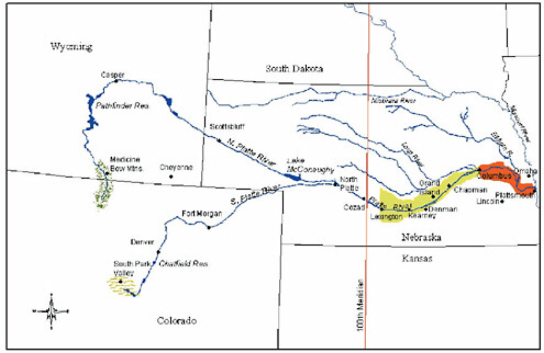
FIGURE 2-1 General location and places of interest in Platte River Basin, including its position across 100th meridian. Central Platte designated in yellow, lower Platte in Orange. Source: Adapted from DOI 2003.
the modified hydrology and geomorphology of the river. The upstream boundary of the central Platte River is the Johnson-2 (also known as J-2) return (the point at which water may either be returned to the south channel of the Platte River or be diverted into the Phelps County Canal). Upstream of that point, the channel is substantially dewatered by diversions. Downstream of that point, Johnson-2 return flows, local storm runoff, and returns from irrigated fields provide continuous flows even during nonflood periods. The division between the central and lower Platte River at Columbus corresponds to the entry of the Loup River.
The western mountains of the Platte River Basin have peaks above 14,000 ft (4,200 m), and the precipitation they intercept creates runoff, which, with groundwater base flow, provides most of the water that flows through the Platte River. The Great Plains form a ramp that slopes gently eastward from the base of the mountains, descending from almost 6,000 ft (1,800 m2) on the Colorado Piedmont in the West to less than 1,000 ft (300 m) at the Missouri River. This plains region—characterized by sand and loess (fine silt) sheets, sand hills, and planar surfaces—is slightly dissected by the regional rivers (Figure 2-2). The Platte River Valley, bounded by bluffs of unconsolidated sands and silts, includes a flat floor and the river, a wide sandy ribbon of intersecting channels, and numerous vegetated islands (Figure 2-3).
HUMAN USE OF PLATTE RIVER BASIN
European perceptions of the geographic area encompassing the Platte River have always focused on its water. Until the twentieth century, the region east of the Rockies was described as high plains and prairie, with the division somewhere near the 96th to 98th meridian. However, much of the national perception of the region was based on the Great American Desert label derived from the reports of the expeditions of Zebulon Pike in 1806-1807, Stephen H. Long in 1819-1820, and others. Long’s 1823 map labeled the central plains as the Great American Desert (Long and James 1823), helping to perpetuate a perception that had already become firmly established (Webb 1931).
Pre-European occupants of the western part of the region were nomadic plains tribes, including the Arapaho, Cheyenne, and Dakotah Sioux (Figure 2-4). These were hunting cultures that depended particularly on bison. In eastern and central parts of the region, tribes were more settled. The Pawnee, for example, were farmers; they occupied lodges for about 10 years at a time (Holmgren et al. 1993). They occupied the central Platte in Nebraska and other areas, including the Loup River, cultivating crops, gathering wild fruits and vegetables, and hunting bison and other wildlife. Early Euro-American reports indicated that Indians used cottonwood bark and leaves as food for horses and used wood for fuel, poles, and stakes.


FIGURE 2-3 Channel of Platte River showing its broad, shallow, braided nature. Source: Photograph by W.L. Graf, May 2003.
Euro-Americans followed the Platte River westward, and much of the route remained in use as the Mormon Trail (on the north side of the Platte) and the Oregon Trail (on the south side) from the 1840s to the late 1860s (Brown and Whitaker 1948; Holmgren et al. 1993). The width of the river, its shifting channels, and its soft bed meant that there were few places where pioneers could easily cross. As westward movement of settlers proceeded, so did conflicts with aboriginal Americans. To protect pioneers and control Indian activities, a number of military encampments and forts were established along the Platte and its tributaries, including Fort Kearny, Fort Laramie, and Fort Collins. By 1855, there were violent conflicts between Plains Indians and Euro-Americans, which continued through the Civil War. After the Civil War, General Philip H. Sheridan ordered the destruction of their subsistence resources with the statement “Kill the buffalo and you kill the Indians.” The federal government had removed the tribes from the Platte region by the end of the 1870s. Trapping of beaver and intensive hunting of bison for both strategic purposes and sport characterized the beginning of substantial Euro-American-induced changes in the fauna of the Platte River Basin.
Even before gaining complete control over the Platte River Basin, Euro-Americans were gaining an understanding of the region’s environmental conditions and increasing the use of its resources. The earliest settlers followed the trails to areas in California and Oregon. Perceptions of the region changed as railroads made the high plains and prairies more accessible and more attractive for settlement. John C. Frémont’s 1842 expedition along
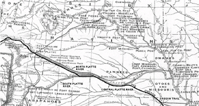
FIGURE 2-4 Portion of Platte River Basin as shown on Map of the Trans-Mississippi of the United States During the Period of the American Fur Trade as Conducted from St. Louis Between the Years 1807-1843. Oregon Trail alignment along central Platte River westward and then along North Platte River is shown by heavy black line. Source: Chittenden 1902.
the Oregon Trail coincided with a period of high rainfall, and settlers traveling in the 1840s experienced relatively wet conditions (Lawson 1974). Terminology shifted from “desert” to “subhumid” and “semiarid” to describe the region (Brown and Whitaker 1948). More settlers came to the Platte River Basin and stayed after the end of the Civil War in 1865 following passage of the Homestead Act of 1862. The Union Pacific Railroad, with a vast amount of granted land along the Platte, contributed to the settlement of the region. The Transcontinental Railroad was completed across Nebraska in 1867 and finished in May 1869. Railroad construction, housing, and fencing stimulated the rapid cutting of available timber.
Settlement and land use in the Platte region were affected by environmental perception and environmental reality. The Great American Desert came to be regarded as a potentially productive agricultural region, perhaps with trends toward increasing rainfall (Brown and Whitaker 1948). The idea that “rain follows the plow,” popular in the 1870s and 1880s, seemed accurate when settlers experienced increasingly abundant rainfall (Glantz 1994). Central plains homestead entries climbed rapidly in the 1880s (see, e.g., Mock 2000). As available rainfall records became longer, however, they revealed alternating periods of relatively abundant moisture and drought. As Saarinen (1966) noted, “although Great Plains wheat farmers are aware of the drought hazard they appear to underestimate its frequency and to overestimate the number of very good years” in spite of being preoccupied with weather conditions and drought potential. Especially severe droughts in the 1930s Dust Bowl period and in the 1950s led to population declines, although many inhabitants held on through difficult periods.
HYDROLOGICAL CHANGES
Three of the most important hydrological changes that have occurred along the Platte River since the early 1880s are the development of reservoir storage in the Platte watershed, the development of extensive irrigated farming, and municipal and industrial water use in growing urban areas.
Reservoir Storage
Reservoir construction began in the Platte River Basin around the beginning of the 20th century and continued until the early 1980s (Table 2-1). The first relatively large dams built in the basin were constructed on the South Platte River: Jackson Lake (1900, 47,000 acre-ft), Lake Cheesman (1905, 87,227 acre-ft), and Antero Reservoir (1909, 115,000 acre-ft). Cheesman Dam was the world’s highest dam at the time of its construction. In 1909, a much larger dam, Pathfinder Dam, was constructed on the North Platte River; its 1,016,500 acre-ft of storage made it one of the biggest dams in the world at that time. Dam construction during the period
TABLE 2-1 Dams in the Platte River Basin
|
Dam |
River |
Height (ft) |
Storage (acre-ft) |
Year Completed |
Drainage Area (mi2) |
Owner |
|
Eleven Mile DBWC |
South Platte |
150.5 |
128,000 |
1932 |
963 |
Canyon |
|
Prewitt |
South Platte (OS) |
42.5 |
51,387 |
1912 |
105 |
LID |
|
Cheesman |
South Platte |
221 |
87,227 |
1905 |
1,750 |
DBWC |
|
Antero |
South Fork South Platte |
53 |
115,000 |
1909 |
185 |
DBWC |
|
Empire |
South Platte |
38 |
52,280 |
1973 |
11.1 |
BIC |
|
Jackson Lake |
South Platte (TR) |
38 |
47,000 |
1900 |
15.9 |
JLRC |
|
Milton Lake |
South Platte |
55 |
39,660 |
1975 |
120 |
FRIC |
|
Julesberg #4 |
South Platte (TR) |
76 |
38,600 |
1910 |
6.5 |
JID |
|
Spinney Mountain |
South Platte |
95 |
83,300 |
1982 |
772 |
City of Aurora |
|
Chatfield Dam |
South Platte |
148 |
355,000 |
1973 |
3,018 |
CENWO |
|
Alcova |
North Platte |
265 |
184,300 |
1938 |
10,376 |
USBR |
|
Glendo |
North Platte |
190 |
1,118,653 |
1958 |
1,500 |
USBR |
|
Guernsey |
North Platte |
135 |
45,228 |
1927 |
2,145 |
USBR |
|
Pathfinder |
North Platte |
214 |
1,016,500 |
1909 |
14,600 |
USBR |
|
Seminoe |
North Platte |
295 |
1,017,279 |
1939 |
7,210 |
USBR |
|
Kingsley |
North Platte |
162 |
1,900,600 |
1941 |
|
CNPPID |
|
Southerland |
North and South Platte |
30 |
65,000 |
1935 |
|
NPPD |
|
Johnson Lake |
Platte Canal |
24 |
59,000 |
1941 |
|
CNPPID |
|
Riverside |
Sanborn Draw |
41 |
94,500 |
1904 |
89.7 |
RID |
|
Abbreviations: BIC, Bijou Irrigation Company; CENWO, Corps of Engineers Northwestern Division Omaha District; CNPPID, Central Nebraska Public Power and Irrigation District; DBWC, Denver Board of Water Commissioners; FRIC, Farmers Reservoir and Irrigation Company; JID, Julesburg Irrigation District; JLRC, Jackson Lake Reservoir Company; LID, Logan Irrigation District; NPPD, Nebraska Public Power District; OS, off stream; RID, Riverside Irrigation District; TR, tributary; USBR, U.S. Bureau of Reclamation. Source: USACE 1996. |
||||||
was primarily in response to the need for irrigation water and municipal water. From 1910 to 1939, a series of dams were constructed in the South Platte Basin (Julesburg, 1919, 38,600 acre-ft; Prewitt, 1912, 51,387 acre-ft; and Eleven Mile Canyon, 1932, 128,000 acre-ft) and in the North Platte Basin (Guernsey, 1927, 45,228 acre-ft; and Alcova, 1938, 184,300 acre-ft). From the late 1930s to the late 1950s, storage in the North Platte Basin increased dramatically with the construction of three dams that added over 4 million acre-ft of storage (Seminoe, 1939, 1,017,279 acre-ft; Kingsley, 1941, 1,900,600 acre-ft; and Glendo, 1958, 1,118,653 acre-ft). The largest dam in terms of storage quantity is Kingsley Dam. Its reservoir, Lake McConaughy, impounds a maximum of 1.743 million acre-ft (2.15 km3) at
elevation 3,265 on the North Platte River (Figure 2-5). The South Platte Basin in Colorado added a series of off-stream storage reservoirs during the 1970s and 1980s, although the volume added was less than 600,000 acre-ft (Empire, 1973, 52,280 acre-ft; Chatfield, 1973, 355,000 acre-ft; Milton, 1975, 39,660 acre-ft; and Spinney Mountain, 1982, 83,300 acre-ft).
Water supplies in the Platte River Basin are augmented by transbasin diversions. The Colorado-Big Thompson project diverts about 400,000 acre-ft of water annually from the Colorado River Basin to the South Platte River. Tunnels conduct the water under the Continental Divide and empty it into Big Thompson Canyon, a tributary of the South Platte River north of Denver. Water is also shifted from the North Platte to the South Platte by a diversion west of the town of North Platte, Nebraska. In sum, all the dams in the Platte River system are capable of storing more than 6 million acre-ft of water (Figure 2-6). They provide water for a distribution system of almost 90 canals on the Platte River in Nebraska that was essentially complete by 1930 (Eschner et al. 1983). Additional flows occasionally occur in
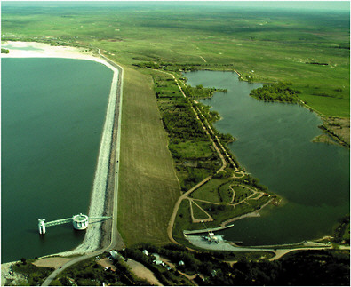
FIGURE 2-5 Kingsley Dam on North Platte River, completed in 1941, directly controls flows downstream through central Platte River. Source: Photograph by W.L. Graf, May 2003.
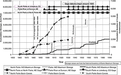
FIGURE 2-6 Cumulative storage in reservoirs, number of canals constructed, and selected stream gage periods in Platte River Basin. Cumulative storage in reservoirs increases over time in form of step functions at lower right, because as new reservoirs were added storage increased at date of closure. Extent of canals caused more gradual increase in total cumulative number of canals as shown at lower left. Canal construction was earlier than construction of large dams. Stream gage records, shown by lines at top, include most of postdam period but little of predam period. Source: Adapted from Eschner et al. 1983.
the river as a result of runoff from local rainstorms and from drainage of irrigated areas. Early gage records (“gage” is the hydrological term for “gauge”) indicate that before 1930 the mean annual water yield of the Platte River at North Platte, essentially the upstream end of the portion of the river of interest in this report, was about 2.2 million acre-ft (2.7 km3). That diminished to about 590,000 acre-ft (0.7 km3) per year in the period 1930-1970 and was about 650,000 acre-ft (0.8 km3) per year after 1970 (Simons and Associates 2000).
The dams, reservoirs, canals, and hydroelectric plants provide valuable benefits to the economy of the region. For example, on the north bank of the river in the Big Bend reach, the Nebraska Public Power District supplies irrigation water for 35,000 acres (14,000 ha) of productive farmland (Nebraska Public Power District 2003); the district generates enough electricity from its water-driven power stations to supply the needs of 111,000 homes. South of the river, the Central Nebraska Public Power and Irrigation District system provides additional power generation and supplies water to more than 112,000 acres (44,800 ha) of irrigated land.
Irrigated Farming
The development of storage water made water supplies for irrigation more reliable. Today, there are more than 1.1 million acres of farmland irrigated with surface water in Colorado, more than 600,000 acres in Nebraska, and nearly 300,000 acres in Wyoming. Of all this irrigated land (approximately 2 million acres), nearly 1 million acres in Colorado and Nebraska are supplied by the South Platte River, 750,000 acres by the North Platte River, and over 200,000 acres by the Platte River mainstem. Water storage and distribution systems have produced an artificial water network along the central Platte River (Figure 2-7).
In the middle and lower Platte hydrological subregion, the general area of concern in this report, agriculture consumes 1,366,400 acres-ft (1.7 km3) of surface water annually (Nebraska Natural Resources Commission 1994); additional substantial (but unmeasured) quantities are pumped from groundwater. This subregion is the most intensely irrigated region in Nebraska (Figure 2-8). Agriculture uses 90% of the water consumed in Nebraska (Nebraska Natural Resources Commission 1994); thus, agriculture will be an integral part of any solutions related to water for threatened or endangered species. In addition to irrigation for agriculture, benefits of the water projects include flood suppression downstream and flatwater recreation opportunities on the reservoir surfaces behind the dams.
Farming in the Platte River Basin has become highly mechanized and specialized, and farms are becoming larger and fewer. Shifts in agriculture occurred with increasing availability of irrigation water, changing technology, the growing importance of economies of scale, and social changes.
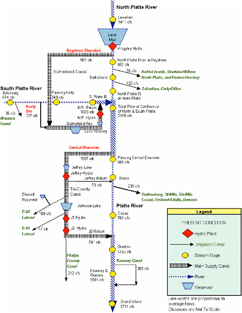
FIGURE 2-7 Schematic diagram showing distribution and connections among Platte River and various parts of its water-control infrastructure. Source: DOI 2003.
Oats, barley, and fruit and vegetable crops, formerly common, are now rarely grown. Improved efficiency in farming practices is evidenced by the number of corn acres remaining steady while production has increased by more than 700%.
Corn is the most important crop in the central Platte region of Nebraska, and the top counties in production of corn for grain (not for silage
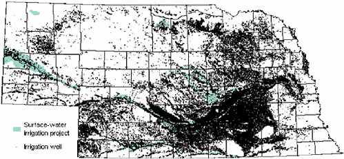
FIGURE 2-8 Irrigation water from groundwater and surface water in Nebraska (black dots are irrigation wells). Source: Winter et al. 1998.
or forage) in the state are here (Figure 2-9). Several of the most important hay-producing counties in Nebraska also are in the central Platte area. Further to the west, wheat is important.
Corn, in particular, is irrigated (Figure 2-10), although irrigation of the other crops, including sorghum and soybean, also is substantial. According to the Nebraska Agricultural Statistics Service (2004), in 2002 Nebraska farm-
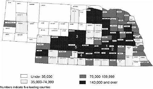
FIGURE 2-9 Distribution of Nebraska corn harvest of 1996 (a typical year), showing acres harvested for grain, 1996, and importance of agriculture and corn production along Platte River. Source: Nebraska Agricultural Statistics Service 2002.
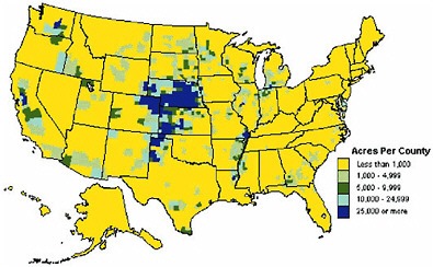
FIGURE 2-10 Distribution of irrigated corn production in 1997 (a typical year), showing irrigated corn for grain or silage by county, 1997, and prominence of Nebraska and Platte River. Source: NASS 1999.
ers planted 8,875,000 acres of corn of which 8.4 million acres was planted for grain and 475,000 acres for silage. Some 58%, about 4.9 million acres, of the corn for grain and 31% of the corn for silage were irrigated. The fraction of all acres of corn that are irrigated varies greatly in the state. It is difficult to extract the “basin acres” from the statistics, because the census is created by county and not by watershed. Counties adjacent to the Platte River have irrigation coefficients ([irrigated acreage for corn for grain]/[total acreage for corn for grain]) of 54% to 96%. About 44% of soybean crops (207,000 acres) was irrigated in Nebraska in 2002. Where soils and topography are suitable but irrigation water is unavailable, dryland crops, such as wheat, may be grown. In 2002, 8% of wheat crops (129,000 acres) were irrigated in Nebraska (Nebraska Agricultural Statistics Service 2004).
In addition to crops, agriculture in the region includes livestock—predominantly feeding operations for beef cattle. In portions of the basin with rugged topography and without adequate access to irrigation water, open livestock grazing has been the dominant land use.
Surface-water diversions for irrigation began in the central Platte area as early as the 1850s and 1860s (Eschner et al. 1983). Irrigation-ditch or canal construction proceeded during the 1890s drought years, and use of groundwater for irrigation began in the late 1800s. Groundwater use increased in the early 1900s and again after about 1950 with the development of center-pivot irrigation systems (Figure 2-11). The percentage of farmland
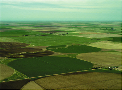
FIGURE 2-11 Central-pivot irrigation systems along central Platte River. Source: Photograph by W.L. Graf, May 2003.
under irrigation has continued to expand in recent years. The Census of Agriculture shows 5,807,308 acres of land in farms in the 12 counties along the central Platte1 in 1959. Land in farms in the same area in 1997 was 5,606,895—a reduction of more than 200,000 acres. In contrast, irrigated land more than doubled between 1959 and 1997, from 914,432 acres to 2,125,781 acres. Irrigated acreage in the region now accounts for about 38% of the land in farms, compared with less than 16% in 1959. Although a breakdown of the relative quantities of surface water and groundwater used for irrigation is unavailable, it can be assumed that the growth in irrigation is mostly through increased groundwater uses, because surface water was completely allocated by about 1930. Some of the increase may also be due to increasing efficiency of water use and an ability to spread a given allocation over a larger area of land effectively.
The importance of irrigation to agriculture in much of Nebraska is illustrated by agricultural-land prices. For Nebraska as a whole, the 2001-2002 average dryland cropland value was $798 per acre (with no irrigation potential); center-pivot-irrigated cropland was valued at $1,513 per acre,
and gravity-irrigated cropland at $1,800 per acre (Johnson and Kuenning 2002). In the area to the north of the Platte’s Big Bend, the difference is even more pronounced: gravity-irrigated cropland was valued at $1,825 per acre, in contrast with a dryland average of $680 per acre.
State and federal policy decisions affect Nebraska agricultural practices, which in turn have environmental implications. Such policies include conservation programs and decisions to help control production, prices, and environmental effects of farming. The effects of agriculture vary with the intensity of cultivation and grazing, which varies with prices received for farm and ranch products, as well as with public policy. Federal policy in the 1950s made conservation through enrollment in the Soil Bank program possible; such enrollment paid farmers to not produce (this helped to control commodity prices and soil erosion). In the 1970s, federal farm policy promoted plowing “fencerow to fencerow” (and removal of fencerows to create larger farm fields) to promote higher production for international trade, but the 1980s saw a return of a program of soil conservation and temporary land retirement with establishment of the Conservation Reserve Program. Preferential crop subsidies, indebtedness and the banking system, and international market prices all exert pressure on particular types of production.
Municipal and Industrial Water Use
With the exception of the Colorado Front Range area in the South Platte drainage (including Denver) and dispersed small towns and cities, particularly near the railroad, the overall character of the Platte River Basin is agricultural, and it has been relatively sparsely inhabited (Figure 2-12). Other than those urban areas, the watershed is generally less than 10% developed (urban and transportation land), and much of it is less than 2% (NRCS 2001). Population densities of most counties in the basin are below 20 persons/mi2; many are below 6 persons/mi2 (Figure 2-13).
The Denver metropolitan area, however, has grown to over 1 million people. Several of the earliest dams built in the Platte River Basin were to supply water to Denver, but the increased population and demand for water supply are becoming more challenging. Summer water-use restrictions have become the norm for the area as demands outstrip the supply. Other urban areas are likely to look to the Platte for municipal water supplies in the future.
CONFLICTS
As is the case with many western rivers, the surface waters of the Platte are completely appropriated, and conflicts around their use are legendary.
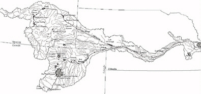

FIGURE 2-13 Gothenburg, Nebraska, typical example of small cities along central and lower Platte River that are stable or growing in size and that serve rural agricultural areas. Source: Photograph by W.L. Graf, May 2003.
A major source of water along the central Platte River Valley is groundwater, but overuse has resulted in serious depletion in some areas. The development of the Platte River for irrigation, hydropower production, flood protection, and municipal water supplies has resulted in a marked shift in the natural flows in the river and in conflicts between stakeholders in the basin. The most important conflicts that have resulted from development include the following.
-
Nebraska vs Wyoming. The principal causes of the conflict are related to the operation of existing U.S. Bureau of Reclamation reservoirs in Wyoming, the construction of new reservoirs or diversion facilities, and pumping of groundwater for irrigation. The dispute and many of its issues have been before the U.S. Supreme Court. The Platte River Cooperative Agreement (1997) is an attempt to solve some of the issues, mainly those associated with balancing the needs of water users and of threatened and endangered species in the central Platte River Basin.
-
Municipal water supply and Colorado’s Front Range. Before 1980, the Denver area relied on the development of the Two Forks project2 to supply the next major increment of storage to meet the region’s growing demand. In 1982, regional water providers came to an agreement that this source would be the most acceptable to the region and began the process of seeking permits from regulatory agencies. On June 5, 1996, the U.S. District Court for the District of Colorado upheld Environmental Protection Agency (EPA) rejection of the project. Since then, the region has explored increased conservation and the integration of existing water supplies as methods to deal with water shortages.
-
Maintenance of flows and wetlands for threatened and endangered species. The maintenance of flows has become one of the most important issues in the basin. This dispute is focused on the habitat needs of federally listed birds (the piping plover, the interior least tern, and the whooping crane) and on the pallid sturgeon and other aquatic species. The concern has been expressed most urgently in the central Platte River Valley in Nebraska, where the need to provide adequate streamflows and habitat for those species has become the focus of conflicts between irrigation and environmental interests.
GROUNDWATER
The spatial and temporal variability that characterizes surface water in the Platte River Basin are also distinctive features of its groundwater. Stream flow and precipitation have always contributed directly to groundwater, so the amounts and locations of subsurface water have changed in response to long-term meteorological events. Irrigation influences groundwater levels, especially infiltration from field applications and leaking canals and withdrawals from pumping wells. When irrigation water is overapplied, the excess seeps past the root zone of the crop and saturates the soil beneath, ultimately connecting to the groundwater table, adding to its volume, and bringing the groundwater table closer to the surface. Despite the physical connections between surface water and groundwater, Nebraska had no legal mechanisms connecting the two until 1996, when the state initiated integrated water management.
Nebraska’s groundwater supplies are extensive, and the state is the third-largest user of groundwater in the nation, behind California and Texas (both of which are much larger than Nebraska). Most of the state’s domestic water supply comes from groundwater, and groundwater supports the majority of
irrigated agriculture. The Nebraska Department of Water Resources records as of October 2002 indicated that there were nearly 93,000 registered irrigation wells and 15,000 domestic wells in the state (Nebraska Department of Environmental Quality 2002). Groundwater quality is generally good, although many wells have high nitrate concentrations—often above the EPA maximum contaminant level (MCL) of 10 mg/L—and atrazine concentrations above the MCL of 3 µg/L because of the use of agricultural fertilizers and biocides (Nebraska Department of Environmental Quality 2002).
The aquifer is part of the High Plains Aquifer that extends from South Dakota to Texas. The geology underlying the Platte River in the study area is described by Hurr (1983) as follows:
The Platte River in South-central Nebraska is underlain by alluvial clay, silt, sand, and gravel of Quaternary age deposited in a series of broad troughs eroded into the underlying clay, silt, sand and gravel of Tertiary age, and shales and limestones of Cretaceous age. The Tertiary formation is the Ogalalla Formation. The Cretaceous rocks are the Pierre Shale and the Niobrara Formation. The Quaternary alluvium contains the principal aquifer in the area and consists of inter-fingering lenses and beds of unconsolidated clay, silt, sand and gravel. The lower one-half of this unit is predominantly clay or silt and the upper one-half is predominantly sand and gravel with some beds of clay or silt.
The thicknesses of individual layers in the aquifer vary widely over short lateral and vertical distances. Depth to the water table is small, usually less than 50 ft; near the river, it is generally 5-10 ft.
Role of Groundwater in Platte River Management
Groundwater is hydrologically connected to surface water in the study area and is likely to affect riverine conditions. Management solutions that do not include a comprehensive view of water supply in the study area are not likely to be successful over the long term. If groundwater conditions are not considered, efforts to modify the channel and provide specific water flows to shape habitat conditions may not have the desired effect. Controlling depletions from well pumping will be required in order to have an effective water management system.
Historical Perspective on Groundwater Use in Nebraska
Groundwater in Nebraska is not privately owned but can be used by overlying landowners pursuant to the reasonable-use doctrine, which allows pumping for any beneficial use without protection for senior water users. Generally, permits are not required for establishing a right to pump groundwater; landowners may use groundwater without waste, subject to
sharing by competing users during periods of shortage (the correlative-rights doctrine) (Aiken 1987).
Initial development of agriculture in Nebraska was influenced by a desire to facilitate surface-water-based irrigation facilities, starting with the adoption of the state irrigation code of 1895, which was followed by the federal 1902 Reclamation Act (Aiken 1987). However, a legal decision in 1936 limited interbasin transfers (Osterman v. Cent. Neb. Pub. Power & Irrigation Dist., 131 Neb. 356, 268 N. W. 334 [1936]) and temporarily reduced the ability to import additional surface-water supplies (Aiken 1987). That decision, in combination with severe drought and the development of the turbine pump, resulted in the rapid development of huge acreages using groundwater (Aiken 1980). Increased use lowered the level of groundwater in some areas, including the central Platte River Basin (Ellis and Pederson 1986), and led irrigators eventually to resort once again to surface-water projects after the Osterman decision was reversed in 1980 (206 Neb. 535, 294 N.W. 2nd 598). Groundwater now irrigates three times as much acreage in Nebraska as surface-water sources (streams and reservoirs).
Nebraska has 23 natural resources districts, 15 of which have established groundwater-management areas over all or parts of their districts to address groundwater quality or quantity. Historically, Nebraska water law failed to address the connection between surface water and groundwater. In fact, Nebraska was the only western state that did not legally recognize tributary groundwater before 1996 (Aiken 2001). In 1996, integrated water-management authority was provided to the natural resources districts and the Nebraska Department of Natural Resources through the Nebraska Ground Water Management and Protection Act. The regions of authority are complex, and most are yet to be implemented, but the Upper Republican District has limitations on drilling new wells and limits on pumping wells because of legal concerns related to the aquifer it shares with Kansas. The North and South Platte Natural Resources Districts have established moratoria on the development of new wells that supply more than 50 gal/min in all (North Platte) or portions (South Platte) of their districts, and groundwater is now being allocated in the Pumpkin Creek Basin subarea (NPNRD 2003; SPNRD 2003). Although establishing the authority to manage surface water and groundwater is a first step, it is not clear that the natural resources districts, as currently constituted, will provide adequate management of groundwater. There are no restrictions on current (as opposed to new) groundwater pumping in the central Platte River Valley.
Current Dynamics
Groundwater flows down-gradient (from areas of high pressure to areas of low pressure) because of gravity. In the Platte River Valley, shallow ground-
water and surface water often are hydrologically connected; that is, water that has flowed in the river through one stream segment may percolate into the ground through another segment, depending on substrate conditions and on whether the groundwater level is above or below the water level in the river. When the groundwater table is lower than the river, that stretch of river is a “losing” stream—the river is recharging the groundwater. If the groundwater table is higher than the river, the river will be a “gaining” stream.
A 1986 study of groundwater and surface-water conditions along the central and lower Platte (Nebraska Department of Natural Resources 1986) indicated that groundwater seepage into the river occurs from both sides of the Platte River between North Platte and Kearney. The seepage is greater now than it was under natural conditions because mounding of the water table due to canal leakage and application of water for irrigation has steepened the water table slope toward the river. Beginning at about Kearney and continuing into Merrick County, the water table slopes northeastward away from the river instead of toward it, and the river thus becomes a losing stream by providing recharge to the adjacent aquifer. In much of the same reach, the water-table slopes away from the river on the south side also and thus the river loses water by seepage in that direction too. Figure 2-14 further depicts the increase and decrease in groundwater levels in Nebraska due to groundwater and surface-water irrigation.
U.S. Geological Survey groundwater contour maps (Figure 2-15 and Figure 2-16) indicate that in 1931, the Platte River from Kearney to Grand Island generally was losing water to the aquifer, whereas groundwater contours from 1995 show that the river was gaining water from the groundwater supply. The reversal is most likely due to accumulation of a groundwater mound from deep percolation of agricultural water, primarily derived from surface water imported by irrigation districts.
The relationships among groundwater, surface water, and the elevation of the groundwater table are crucial to maintaining water levels in the river during low-flow periods, and they influence vegetation in and near the river. The portion of the flow in the river derived from groundwater is “base flow.” Reductions in groundwater levels can reduce base flow, a condition that is observed elsewhere in the United States (Glennon 2002). The Platte River in the study area is unusual in that increased groundwater pumping appears to have been offset in some areas by return flows from imported surface water. Any increases in groundwater withdrawals and reductions in surface-water deliveries are likely to affect riverine habitat. Wet meadows that are important crane habitat may be supported by high groundwater levels and streamflow (Currier 1995), although alternative explanations, such as limited percolation of snowmelt and spring rains through frozen soil, have also been offered (Michael Jess, University of Nebraska, pers. comm., August 2003).
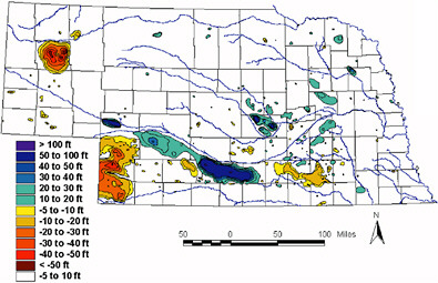
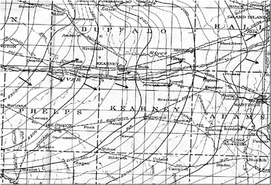
FIGURE 2-15 Map of elevation of groundwater table in 1931 shown as contour surface. Water flows downgradient and generally eastward and southeastward. Compare with Figure 2-16. Source: Adapted from Woodward 2003.
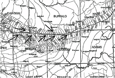
FIGURE 2-16 Map of elevation of groundwater table in 1995 shown as contour surface. Substantial elevation of surface has occurred since 1931 in western part of map. Compare with Figure 2-15. Source: Adapted from Woodward 2003.
The importance of the relationship between groundwater levels and river flows and of the impact of well pumping on river flow and habitat quality is well recognized by the drafters of the cooperative agreement (Aiken 1999):
Under the Cooperative Agreement, all three states must develop a water depletion tracking and accounting system that will identify what water use activities are depleting Platte River flows. In Nebraska, this will also include identification of wells the pumping of which may reduce flows in the Platte over time. New surface and groundwater use begun after July 1, 1997, are subject to replacement water requirements.
The first phase of the $7 million Cooperative Hydrology Study (called COHYST), paid for by the Environmental Trust Fund as a component of the cooperative agreement, is nearing completion. Its focus is on modeling and mapping hydrologically connected groundwater in parts of 43 counties, mostly in Nebraska but extending 6 mi into Wyoming and Colorado along the North and South Platte Rivers. The area includes about 67,000 wells, mostly for irrigation; about half were installed in the 1970s (COHYST 2003). The findings of this comprehensive modeling effort will contribute to understanding of the causes and effects of changes in the groundwater table elevation near the Platte River.
Implications of Climate Variability and Change
Although groundwater levels respond more slowly to climatic conditions than do surface-water flows, long-term climate trends do affect groundwater levels. Even multiyear “snapshot” views of groundwater conditions or surface-water flows may miss multidecadal trends. Climate conditions affecting Platte River flows in the early part of the twentieth century were generally wetter than they were in midcentury, and there was another wet period from the late 1970s to the middle 1990s (Lewis 2003). Those conditions are probably related to global climate patterns that are affected by ocean temperatures and changing atmospheric circulation patterns. It is critical to understand that climate conditions since the early 1990s (when much of the habitat information the committee was asked to review was generated) are not typical of the entire twentieth century. Average annual precipitation has decreased by more than 7.5 in. in the last decade in Nebraska (NCDC 2003), temperatures have been higher than historical averages, and streamflow has been affected by serious drought. Surface-water deliveries to agriculture have also varied in response to the factors described above. Therefore, the presence or absence of groundwater mounds and quantification of depletion effects of wells need to be understood in a long-term context; but long-term data are sparse.
Potential implications of long-term climate change associated with global warming will add more uncertainty to management of the critical habitat and reaffirm the need to be cautious about conclusions related to habitat quality and water-flow requirements. Climate-model scenarios project that temperatures will continue to rise throughout the region and that the largest increases will be in the western parts of the plains (USGCRP 2000a,b). Conclusions related to increases in temperature (and therefore increases in evaporation) are relatively reliable, but implications for precipitation are less certain.
RIPARIAN VEGETATION CHANGES
The vegetation of the Platte River watershed varies sharply from west to east along a steep gradient of annual rainfall. Coniferous forest predominates in the Rocky Mountains; at lower elevations in the Great Plains, the rivers flow mainly through grassland vegetation of several types—short grass in the drier west and mixed grass and tall grass in the more humid east. In the grassland region, deciduous forest (principally Populus and Salix) is largely restricted to floodplains, such as the Platte River Valley. Changes in slope, substrate, temperature, hydrology, frequency of fire, and grazing along the Platte River from its headwaters to its mouth influence the biodiversity and ecology of individual river segments. The coarse substrate, steep slopes, and coniferous forests of headwater reaches contrast with the fine shifting substrates, gentler slopes, and riparian vegetation (currently dominated by deciduous trees and shrubs) of downstream reaches.
Early explorers indicated that the floor of the Platte River Valley was a mosaic of upland grassland away from river channels, meadow and marsh vegetation on low terraces near the river, woodland and shrubland on islands, and scattered timber on the banks. Observations during the Long Expedition (1822-1823) included the following (Long and James 1823):
Soon after crossing the Elk-horn we entered the valley of the Platte, which presented the view of an unvaried plain, from three to eight miles in width, and extending more than one hundred miles along that river, being a vast expanse of prairie, or natural meadow, without a hill or other inequality of surface, and with scarce a tree or a shrub to be seen upon it. The woodlands, occupying the islands in the Platte, bounded it on one side; the river-hills, low and gently sloped, terminate it on the other.
Through their storage capabilities and the resulting alterations in flow regime of the Platte River, the dams and diversions have led to geomorphic and vegetation changes along the downstream corridor. At North Platte, the average annual peak flow was about 14,000 cfs (400 m3/s) before 1930;
after that time, it was only about 3,200-3,400 cfs (90-95 m3/s). The year 1930 is selected largely for convenience because that year saw the installation of new gaging methods and the establishment of a new gaging site near Duncan. It also predates the completion of three of the four largest dams in the Platte River Basin. Because flood flows are important in forming and changing the channel, geomorphology of the stream has undergone substantial adjustment, including a reduction in the active channel width. Initial diversions of flows reduced water discharges, exposed more river-bed surfaces, and created new and larger areas for vegetation to establish. Improved reproduction and survival of cottonwood and willow resulted in considerable woodland expansion in most reaches of the river (Figures 2-17 and 2-18); this expansion apparently had ceased by the late 1960s or earlier on some reaches (Currier 1982; Johnson 1994).
Native vegetation associated with the Platte River was broadly categorized by Currier (1982) and Johnson (1994) as grass and sedge meadows on low-lying flats bordering the outer banks of the river, open- and
FIGURE 2-17 View of Platte River near Cozad, Nebraska, showing conditions in 1866, about 20 years after extensive wood use by immigrants, soldiers, and railroad crews. Photograph probably taken when river was in flood. Source: Carbutt 1866a. Reprinted by permission of Union Pacific Historical Collection.
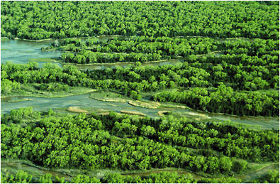
FIGURE 2-18 View of riparian and channel woodlands on central Platte River, showing conditions in part of river in 2003. Source: Photograph by W.L. Graf, May 2003.
closed-canopy woodland (Populus, Salix, Fraxinus, and Ulmus), shrubland (Salix and Amorpha) along channels and on small river islands, and ephemeral vegetation comprising largely annual plants (Cyperus, Echinochloa, Xanthium, and Eragrostis) that quickly germinate and fruit on newly exposed sandbars in middle to late summer (Figure 2-19). Submerged aquatic macrophytes and emergents are not common in the Platte River, but backwater areas support stands of Typha, Phragmites, Elodea, and Potamogeton.
Expanding woodland is reported as a primary cause of reduction in the suitability of the Platte River as habitat for the nesting or roosting of endangered or threatened aquatic avifauna. Sandhill and whooping cranes prefer roosting in wide river channels away from tall riparian vegetation (Krapu et al. 1984; Faanes et al. 1992). Terns and plovers prefer to nest on bare or sparsely vegetated sandbars (Ziewitz et al. 1992). Thus, central issues in the vegetation-bird connection are the extent to which vegetation in the river has changed, the causes of changes, and the degree to which vegetation limits or may limit the recovery of these avian species.
How has the vegetation of the Platte River changed historically? Investigators in the United States often use General Land Office (GLO) surveys to develop baseline (presettlement or early-settlement) conditions from which to measure the trajectory of change or to develop targets for restoration (Stearns 1949; Whitney and DeCant 2001). Maps drawn from the
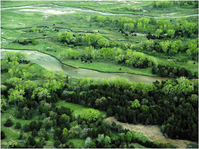
FIGURE 2-19 View of highly varied habitats on portion of central Platte River, showing range of density of tree cover in some locations from dense woodland to open woodland and treeless areas that is reminiscent of reconstructions of predevelopment conditions in some reaches as suggested in Figure 2-20. Source: Photograph by W.L. Graf, May 2003.
surveyors’ notes (plat maps) have been used extensively to determine the physical and ecological character of the Platte River before the construction of upstream dams and water-diversion structures. Most studies have used the bank-to-bank widths (minus any in-channel islands shown) measured on the plat maps as the baseline preregulated, open-channel (sand and water) area. For example, Williams (1978) found total (sum of all channels) bank-to-bank widths in the central Platte River to have been 1,200-2,000 m in 1865. Eschner et al. (1983) also used the GLO plat maps to determine baseline channel widths with which to compare more recent measurements from aerial photographs that date from 1938 and later.
Apparently, neither of those studies consulted the field notes on which the plat maps were based. Years after their analyses, on which many reports and legal filings were based, it was discovered that many or most of the small vegetated islands identified in the field notes as abundant were not surveyed and therefore were not drawn on the plat maps (Johnson 1994). Thus, total unvegetated channel widths measured from the plat maps were
overestimated by the early studies. Moreover, the blank space between banks on the maps may have led to the impression that the presettlement Platte River was rather featureless, comprised of large expanses of sand and water, and was generally devoid of trees and other woody vegetation. They may also have led to the conclusion that any riparian vegetation in the modern river is unnatural and a product of flow regulation (Johnson and Boettcher 2000a). A partial reconstruction of predevelopment vegetation with the plat maps and field notes (Figure 2-20) was produced by Johnson and Boettcher (1999).
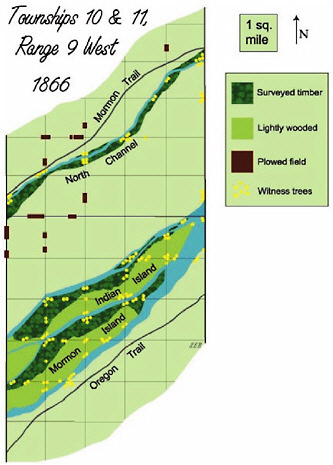
FIGURE 2-20 Reconstruction of predevelopment vegetation based on GLO plat maps and field notes (source of witness tree data) for two Platte River townships. Small unsurveyed riverine islands are not shown. Light green areas were considered as typified by grassland; two types of timbered areas are also noted, as well as some agricultural activity. Source: Johnson and Boettcher 1999. Reprinted with permission; copyright 1999, Land and Water, Inc.
The concept of a largely nontimbered river was bolstered by photographs showing a mostly treeless river near wooden bridges during early settlement (Williams 1978). However, the photographs were taken many years after Fort Kearny was built, 350,000 pioneers had passed by the Platte River on the Oregon Trail, the Union Pacific Railroad had been completed, and many farms were built and fenced. Virtually no wood was available in the vast grassland bordering the Platte River, so the high wood use associated with those human activities led to deforestation wherever there were trees, including islands within the Platte River (Johnson and Boettcher 2000a). The earliest photographs were taken too late to record the natural extent of woodland in the presettlement Platte River Basin. The most recent assessments based on the survey notes and plat maps portray the presettlement Platte as a river that had scattered trees on its outer banks but also was well studded (“immense numbers” was also used by the surveyors) with wooded islands of all sizes throughout its length. Cottonwood and willow trees dominated both the presettlement and modern floodplain vegetation of the Platte River; the exotic Russian olive and native red cedar are now abundant but were not so historically (Currier 1982; Johnson and Boettcher 2000a). The open, savanna-like nature of presettlement woodlands on large, higher islands just above floodplain level may have been the product of prairie fires, competition with grasses, and wood use and horse pasturing by American Indians. Smaller, floodplain-level islands were probably more protected from fire and had well-developed middle-story and upper-story vegetation. Current woodlands along many parts of the central Platte River have high tree density and well-developed, shrubby understories. Those conditions are different from the complex of wooded islands and large expanses of open water, sandy beaches and islands, and low-growing ephemeral vegetation shown in the earliest aerial photography from the 1930s (Box 2-1).
GENERAL SPECIES RESPONSES TO EUROPEAN SETTLEMENT
Invertebrates
The aquatic invertebrates of the Platte River in Nebraska include 18 species of unionid mollusks (Hoke 1995) and 63 taxa of insects (McBride 1995). The common taxa of insects include Ephemeroptera (Caenis, Tricorythodes, and Heptagenia), Plecoptera (Isoperla), Odonata (Argia and Gomphus), Hemiptera (Corrixidae and Gerridae), Coleoptera (Elmidae and Dytiscidae), Trichoptera (Hydropsyche and Cheumatopsyche), and Diptera (Dicrotendipes, Cladotanytarsus, Chironomids, and Rheotanytarsus). Most of the taxa belong to the collector-gatherer or collector-filterer functional feeding groups and occupy the shoreline habitats rather than the more abundant, shifting sandbar habitat. Analysis of macroinvertebrate densities
|
BOX 2-1 What was the areal extent, composition, and structure of vegetation communities along the central Platte River before European settlement, and what controlled their dynamics? The significance of this question is that modern attempts to restore the river to greater functionality for wildlife using open riparian areas requires knowledge of its original condition. “Original” in this case refers to conditions before European settlement, the imposition of land-use changes, and the installation of river-control structures, such as dams and diversions. Present-day human activities in and near the river, and throughout its drainage area upstream, make it impossible to completely restore presettlement vegetation communities. A riverine environment less modified than the present one may be possible, however, and may be beneficial to the endangered species and to other species using the area. The nature of the presettlement vegetation communities of the central Platte River has become better known, but some details are the subject of debate. The most recent summary discussions in the refereed journal literature are by Johnson and Boettcher (2000a,b) and Currier and Davis (2000). These and other interpretations rely on historical descriptions of the river and its vegetation, including journal entries of early travelers, soldiers, and settlers. One source of historical conditions is photography of the river, but few images are available, and their coverage does not begin until the 1860s. The earliest systematic information is from General Land Office (GLO) surveys conducted along the central Platte River in 1859-1869. The general objective of the surveys was to lay out the township and range system before organized settlement. The survey records include plat maps and surveyors’ notes describing conditions along the survey lines. Two divergent views of the river emerge from the historical information: the Platte was a wooded river coursing through a prairie landscape and the Platte was a prairie river dominated by nonarboreal vegetation. The complex braided system of the historical Platte River provided a variety of physical environments for vegetation, each with a different set of conditions for vegetation. The most commonly recognized settings include the active channel, abandoned channels, banks, low islands, and high islands. The active channel of the river was generally without vegetation except during summer low-flow conditions, when annual plants colonized portions of the exposed bed. Although the stream was not normally more than a foot deep (except during floods), its current was swift, and the unstable sandy sediments were not a suitable substrate for vegetation. The river was so shallow that steamboats and keel boats were not used by the early fur trappers who began using the river as early as 1807, and they relied on bull boats, lightweight wooden-frame craft with stretched animal skins (Chittenden 1935). Before the construction of large storage reservoirs upstream, the active channel was much wider than the present channel, as shown by photographs and aerial photographs made before the complete effects of upstream controls became apparent. Abandoned channels are common in other modern braided systems, and they occurred in the presettlement Platte River. When channels were abandoned by active flows, they sometimes became the location of stable cottonwood forests. A military observer during the middle 1800s described just such a case on the |
|
Platte. Lieutenant Woodbury verbally described and mapped a heavily timbered half-mile-wide strip of trees occupying an abandoned channel near Grand Island. Such dense woodlands probably assumed a patch shape that mimicked the shape of the underlying abandoned channel, a geometry commonly observed in other modern rivers on the plains. During the presettlement period, the outer banks of the central Platte River marking the general limits of fluvial activity were apparently the locations of cottonwood-dominated woodlands, with trees growing in isolation from each other or in limited groves. Accounts of surveyors and travelers usually described the trees on the banks as scattered, sparse, or absent in some cases from the outer, high banks of the river. Cottonwoods along the banks were often in a broken line of trees. Levi Jackman, an 1847 Mormon pioneer, penned a typical description: “cottonwood skirting the river is all the timber to be found, and very scarce at that” (Jackman 1847). This general quote probably indicates the general nature of the banks along the Platte River west of Kearney along the Oregon Trail, which joined the river at that point. The most precise information regarding vegetation along the river is from GLO surveys, cited here and elsewhere in this report, and they specify the vegetation conditions a decade or more after this example representative statement. Willow, prairie shrub, and grasses occurred along with the stream-bank cottonwoods in a community probably affected by grazing and fire before the intervention of humans several thousand years ago. Bison and deer, for example, grazed the area before the introduction of domestic livestock. The heavy use of the Oregon Trail, which followed the length of the central Platte, introduced exceptionally heavy grazing by the animals of emigrants bound for California, Oregon, and Utah. Grazing was so intense in 1849 and 1850 that travelers who previously had crossed from one side to the other in search of forage found that both sides of the river had been so heavily grazed that no forage remained (Steed 1850). The role of fire, a common feature of the prairie ecosystem, was also likely to have been a control on the structure of vegetation communities on the outermost river banks, but less so on riverine islands. Numerous islands occurred between the high, outer banks and among the multiple channels of the river. They were of two general types: smaller, low islands rising a few inches to a few feet above the average flow of the stream, and larger, high islands that rose several feet above the flow. The small islands were apparently the locations of relatively dense woodlands with substantial understories. GLO surveyors described those islands as “innumerable,” “numerous,” and “scattered promiscuously.” They characterized the river as being “studded with” and “filled with” islands of all sizes. The surveyors used the descriptors “brush,” “brushy islands,” and “covered with timber and undergrowth” for the islands. Surveyors’ 1863 notes for the river just downstream of the town of Grand Island stated that “the greater part of the timber is on the small islands in the Platte River … there are many small islands in the river covered with timber and undergrowth” (cited by Johnson and Boettcher 2000a). Islands between the banks probably hosted relatively dense forest cover with substantial undergrowth because they were probably exposed to lower rates of fire and grazing than the prairies along the banks; present knowledge is insufficient for us to know how much lower. Grass fires can leap across wide unvegetated spaces (Wilson 1988), but the active channel of the central Platte River was a mile or more across, large enough to protect many midchannel islands. One surveyor noted that “there is no timber except that confined to the islands which is protected from the fall fires.” |
|
Fire frequency was probably not reduced as much on the very large, high islands, such as Grand Island, which is so large that fires might have been ignited on the island itself. The island was also separated from the banks of the main river by more narrow active zones than in the case of the smaller islands. The vegetation cover of the very large islands consisted of more scattered cottonwoods, probably with more grass in the understory. In summary, the ecological conditions of the central Platte River in presettlement times is not completely known, and the mechanisms that maintained the vegetation communities and their structure have not been completely investigated. Many details of the early vegetation communities and their structure are open to some debate. There is enough information from early accounts, however, to develop a first approximation: the wide active channels had little or no vegetation except for annual plants during low-flow periods, the banks had scattered trees and small groves with prairie-like vegetation, smaller islands were numerous and heavily wooded with dense undergrowth, and large islands had some woodland and some grassland. A successful restoration of the central Platte River ecosystem will include all those components. |
in the Platte River downstream of the mouth of the Loup (Peters et al. 1989) found that rock substrates supported the highest numbers of organisms per unit area, 65,245/m2; most were chironomids and trichopterans. Sand had the next highest density, 8,218/m2, followed by gravel, 7,576/m2. Invertebrate densities on silt substrates and on submerged wood totaled 6,610/m2 and 6,572/m2, respectively.
The invertebrate community in the Platte River before European settlement is unknown. Woody debris is now an important substrate for aquatic invertebrates, but how important it was in determining invertebrate diversity and abundance before European settlement and water development is undeterminable.
Vertebrates
It is difficult to assess the change in relative abundance or species composition of the various fish, amphibian, reptile, bird, or mammal faunas in response to changes in the hydrology or vegetation of the central Platte ecosystem since European settlement. Data to quantify accurately the comparative abundance of any species then and now do not exist.
Fishes
The present fish fauna of the Platte River includes about 100 species (in 20 families), of which 76 are native to at least a portion of the basin
(Schainost and Koneya 1999). Wide fluctuations in flows with flooding and high turbidity followed by low flows and high water temperatures impose special restrictions on the biota of the Platte River. Many fish species native to the mainstream Platte—including red shiner, sand shiner, river shiner, bigmouth shiner, western silvery minnow, plains minnow, speckled chub, flathead chub, river carpsucker, quillback, and channel catfish—are adapted to widely fluctuating conditions. Pre-1940 records also indicate that several species—such as shovelnose sturgeon, sturgeon chub, and sauger—were found in the Platte River drainage as far west as Wyoming. In addition, headwater, tributary, and spring-fed side-channel reaches support species that require clear or cool water; some, such as horny head chub, have been extirpated from the basin, but others—such as northern redbelly dace, finescale dace, plains topminnow, and Topeka shiner—are found in isolated populations in the drainage. In general, the number of native species declines in the western portion of the basin, where 30 native species have been recorded in the North Platte Basin in Wyoming and 26 in the South Platte Basin in Colorado. In addition, the proportion of nonnative fish species increases to almost 50% in the North Platte Basin in Wyoming and 41% in the South Platte Basin in Colorado (Schainost and Koneya 1999).
Herpetofauna—Amphibians and Reptiles
The herpetofauna of the Platte drainage includes salamanders (two species), frogs and toads (11), turtles (eight), lizards (11), and snakes (29). The most common representatives of these groups along the Platte River are the tiger salamander (Ambystoma tigrinum), the Rocky Mountain toad (Bufo woodhousii), the western striped chorus frog (Pseudacris triseriata), the painted turtle (Chrysemys picta), and the spiny softshell (Trionyx spiniferus).
Birds
A diverse assemblage of birds use the Platte River. The many life-history types include residents (such as blue jays, woodpeckers, and quail), migratory birds that are summer (breeding) residents (such as terns, plovers, warblers, orioles, and kingbirds), and migratory nonbreeding birds that use the river or floodplain only during spring and fall migration (such as cranes, ducks, geese, shorebirds, and songbirds).
The Platte River’s woodlands are especially rich in species. Scharf (2003) netted 77 species on the Platte’s floodplain (grassland, woodland, and channel habitats), including 19 species of summer-nesting neotropical migrants that are in decline in other parts of their ranges (Dobkin 1994; Robinson et al. 1995). Three that nest in riparian woodlands—the
yellow-billed cuckoo, Bell’s vireo, and western kingbird—are considered priority species for conservation in Nebraska because of their continental declines (Forsberg 1999). Colt (1997) captured 50 species of nesting birds in the Platte’s woodlands, of which 31% were neotropical migrants. He also found high fledging rates and low rates of cowbird parasitism. Thus, as the Platte River’s woodlands have expanded coincidentally with water development, songbird populations have increased accordingly, ironically off-setting some of the effects of the huge losses of riparian woodland caused by dam building and poor land management in much of the Great Plains (Knopf et al. 1988). Open (i.e., non-forested grassland or wetland) habitat is also important to bird species of conservation concern in Nebraska (Appendix B). Forty-one (57%) of 72 of these species occur on the central Platte and most (27 species, 66%) of the 41 species are associated with open habitat. Another eight species are characterized by using partially wooded (i.e., open woodland or savanna) habitats. Only six species in Appendix B (American woodcock, black-billed cuckoo, great-crested flycatcher, long-eared owl, ovenbird, Baltimore oriole) require more closed forest.
Large numbers of migratory waterbirds migrate through Nebraska’s central Platte River Basin and adjacent Rainwater Basin area each year. Population surveys and management activities for waterfowl and cranes treat those two areas as one regional staging area because extensive interchange of birds between the two wetland systems occurs (Cox and Davis 2003). Variations in staging bird numbers from one year to another are large because migration patterns are determined by frequent, variable weather systems and by physiological needs of migrating birds. In years when spring advances slowly, larger numbers of birds will stage for longer periods in the central Platte Valley and the Rainwater Basin because conditions farther north are still frozen. In contrast, when spring develops rapidly and over a large area, migrating waterbirds may move through the Rainwater Basin area and central Platte River Basin more quickly (Cox and Davis 2003).
The Rainwater Basin area serves as important habitat for migrating waterbirds but is also susceptible to periodic drought and disease outbreaks (Chapter 5). Waterbird habitats in or near the central Platte River, in contrast, are dominated by flowing water or extensive exchange between groundwater and surface water; these habitats are not as susceptible to the occurrence of drought or disease. The central Platte River, therefore, provides important habitat for spring-staging waterbirds at times when little habitat is available elsewhere and when low temperatures temporarily freeze shallow wetlands in the adjacent Rainwater Basin area.
On the central Platte, the primary types of habitat used by staging waterbirds are open water, wetland, meadows, grassland, and cropland.
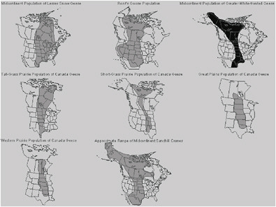
Forest communities in the central Platte River do not provide staging habitat for waterbirds. Four populations of geese, one population of sandhill crane, and several species of ducks depend on current staging habitats (Table 2-2). Over 85% of the midcontinent sandhill crane, snow goose, Ross’s goose, and greater white-fronted goose populations migrate through the central Platte River region. The distribution of those waterbird populations, such as the midcontinent population of sandhill cranes, is now restricted to a narrow band of migration habitat in the central United States (Figure 2-21).
The central and lower Platte River hosts a variety of species, and restoration of the river to benefit one species should not unduly impair other species. That issue arises because clearing woodland areas to benefit whooping cranes that prefer long, open sight lines may reduce the available habitat for songbirds. The lessons from this observation are that such decisions should take into account the general distribution of the species in question, the legal standing of the species, and the ecosystem perspective. First, most of the songbirds have a general distribution in the region (Davis 2001), so the loss of some woodland in and along the river should not adversely affect the general population. However, whooping cranes are strongly connected with the river and its habitats, and there are few alternatives. Wholesale removal of woodlands without regard to the effects on other species would be irresponsible; recognition and mitigation of effects wherever possible constitutes wise management.
Second, The Nebraska Partnership for All-Bird Conservation identified 72 bird species of conservation concern in Nebraska (Appendix B). However, whooping cranes, piping plovers, and interior least terns have special legal standing in that they are federally listed as endangered or threatened species, whereas the songbirds and other bird species of concern are not. That does not mean that the interests of songbird and waterfowl populations may be safely disregarded, but special efforts must be taken on behalf of the listed species.
Finally, an ecosystem perspective would logically suggest that the central and lower Platte River should be a diverse ecosystem when viewed as a whole, with adequate accommodation for both listed and nonlisted species. The diversity ought to be manifest over the entire length of the central and lower river, whereas it might not be present in some localities and areas of restricted spatial extent (a square mile or so, for example). In the final analysis, provision should be made to care for all species, not to see the elimination of one from the total ecosystem of many square miles in extent.
Arriving at clear and achievable conservation goals in situations like these requires good science but also good policy and good process. How those elements are integrated in this report is discussed in Chapter 4.
TABLE 2-2 Proportions of Waterfowl Populations That Use Nebraska’s Rainwater Basin Area and Central Platte River Valley
|
Species |
Population Considered |
Total No. Birds Populationa |
Citation |
Number of Birds in Central Platte River Valley |
Citation |
Proportion of Population Using Central Platte |
|
Sandhill crane |
MCP |
435,050 |
Sharp et al. 2003b |
375,875c |
Solberg 2002b |
86%b |
|
Mallard |
MCP |
7,785,800 |
USFWS 2003 |
4,097,000 |
Gersib et al. 1990 |
50% |
|
Northern pintail |
MCP |
2,547,970 |
USFWS 2003 |
756,000 |
Gersib et al. 1990 |
30% |
|
Total ducksd |
MCP |
34,527,900 |
USFWS 2003 |
23,815,000 |
USFWS 2003 |
61% |
|
Snow goose, Ross, goose |
MCP |
2,490,800 |
USFWS 2003 |
2,679,300 |
J. Drahota, pers. comm., U.S. Fish and Wildlife Service, 2003 |
90% |
|
Canada goose |
GPP/WPP |
651,330 |
USFWS 2003 |
558,000 |
J. Drahota, pers. comm., U.S. Fish and Wildlife Service, 2003 |
75% |
|
Canada goose |
SGPP |
160,570 |
USFWS 2003 |
110,000 |
J. Drahota, pers. comm., U.S. Fish and Wildlife Service, 2003 |
25% |