


Below is the uncorrected machine-read text of this chapter, intended to provide our own search engines and external engines with highly rich, chapter-representative searchable text of each book. Because it is UNCORRECTED material, please consider the following text as a useful but insufficient proxy for the authoritative book pages.
67 This chapter provides guidance on apron planning, design implications, and related regulations/ guidance for various types of airport aprons. The guidance provided incorporates standards and guidance promulgated by the FAA and other industry organizations and sources, as well as apron planning and design best practices. These best practices are not intended to standardize apron facilities at all airports, but to provide planners and designers with guidance that encourages the use of solid professional judgment in planning and designing apron facilities to maintain a safe, secure, and efficient operating environment, while also recognizing the need for flexibility, given the inherently dynamic nature of the aviation industry. This chapter is divided into three sections: planning; design implications and considerations; and related regulations and guidance. Planning Planning Considerations Apron planning requires an understanding of the operations and priorities of the primary users of the apron facilities, as well as the way these facilities interface with the overall airport. Airport operators, airlines, tenants, users, and aircraft servicing companies all operate in apron areas. In terms of apron use and operation, various stakeholders have differing needs and priori- ties that need to be considered in planning these airport components, including functional apron capacity, operational efficiency, flexibility, operational factors, and site constraints. Functional Apron Capacity Apron capacity is typically determined by the number of aircraft that simultaneously can be positioned on the apron and appropriately serviced. However, functional capacity can be characterized and assessed in multiple ways. For example, airline and cargo apron users assess functional capacity in terms of the capability of the area to support the intended aircraft fleet, both in number and size, as well as the storage of GSE necessary to service those aircraft. Airlines consider their planned or projected schedule of aircraft activity (including the fleet mix) in assessing the capacity of the apron and gate area to ensure that peak demand can be accommo- dated. Peaks in demand often vary over the course of a day or night, particularly when aprons accommodate a diverse aircraft fleet over the time period. Examples of activity during demand peaks that may require specific assessment include narrowbody aircraft parking, widebody air- craft parking, international aircraft parking, and overnight aircraft parking. Airport operators assess functional apron capacity in the context of the capability of the apron area to accommodate irregular operations, new users or tenants, or aircraft that are larger than those that were anticipated to be accommodated on the apron. Current aviation demand is rela- tively easy to quantify, but future aviation demand is more difficult to clearly determine. C H A P T E R 4 Apron Planning and Design
68 Apron Planning and Design Guidebook It is prudent to coordinate with the airport operator to assess whether there are known or desired air service changes that could result in a change in the fleet over time. If not considered, it is possible that apron and adjacent taxiway/taxilane facilities would limit the ability to efficiently and safely accommodate larger aircraft, which could introduce a barrier to effective increases in air service. While this is challenging to predict, an airportâs master plan provides insight into potential fleet growth. An airport operator can often enhance this insight with more specific air service marketing plans or analyses. Irregular operations associated with weather events that ground aircraft or special events (air shows, major community events, such as sporting events or conventions, etc.) that may result in extreme peaks in demand for apron parking should be considered in assessing functional apron capacity. Key Points: ⢠Understand the current and future aircraft fleet and related and potential air service demands. ⢠Understand current and forecast schedule fluctuations and peaks over the course of the day/night. ⢠Define potential irregular operations (qualitatively and/or quantitatively). Operational Efficiency Operational efficiency, which is a measure of how effectively an apron area supports day-to-day aircraft operations, influences the planning of apron facilities. The primary measure of opera- tional efficiency is the degree to which aircraft parking and servicing demands can be met without creating dependencies in aircraft parking or maneuvering and without compromising operational safety. Independent aircraft parking is achieved when aircraft approaching or departing from a parking position can enter or exit that position at all times without depending on the exit or repositioning of another aircraft or other equipment on the apron. Dependent aircraft parking typically provides for increased size, type, or number of aircraft that can be accommodated within a specific apron area; however, dependencies among parked aircraft or servicing equipment are created to achieve this increase. The provision of increased parking capability compromises oper- ational efficiency by constraining GSE access to parked aircraft, limiting the ability of aircraft to operate independently, and, in some cases, restricting aircraft access to certain areas of the apron. Operational efficiency is also a function of aircraft taxiing flows to and from an apron. Effi- ciency is maximized with minimal conflict in taxiing flows (intersecting taxiing routes or bidi- rectional flow on a single taxiing route) to, from, and within an apron. Taxiing conflicts require aircraft to slow or stop to safely accommodate other taxiing aircraft, potentially resulting in congestion and queuing; obstruction of adjacent gates/aprons; and reduced apron efficiency. Where sufficient space exists, incorporation of dual taxiways/taxilanes or push-back areas within or adjacent to aprons provides bypass capability that minimizes taxiing conflicts and delays. Separating taxiing routes and GSE routes through dedicated vehicle service roads enhances the safety of both operations and minimizes compromises in operational efficiency. Aircraft servicing requirements, determined in part as a function of the size and type of the aircraft, can involve a significant amount of GSE. Defining an apron layout that facilitates effi- cient aircraft servicing is critical for airline, cargo, and general aviation activities as the efficiency, or inefficiency, of the apron layout can affect schedule integrity, leading to flight delays. Sufficient space is necessary to maintain the efficiency of aircraft servicing by allowing unimpeded and independent GSE access to the aircraft. GSE should be able to approach an aircraft from both sides, and be positioned on all sides during servicing.
Apron Planning and Design 69 Key Points: ⢠Conceptualize aircraft access and circulation routes within and adjacent to the apron. ⢠If available space or operational factors are limiting, consider whether creat- ing dependencies in parking or servicing would provide for the achievement of objectives. If so, assess the consequences to determine acceptability. ⢠In some cases, compromises in operational efficiency may be acceptable in order to accommodate apron demand. Flexibility Recognizing that aircraft fleets are not static and that equipment continues to evolve dimen- sionally, operationally and technologically, the flexibility of an apron is critical to accommodating short-term and long-term aircraft parking demand. Additionally, the way that airport operators use aprons can change to reflect changing operational characteristics (hourly peak activity, hub- bing operations, deicing, overnight parking, temporary aircraft staging, etc.), particularly com- pared to the characteristics that were current when the aprons were originally planned/designed. To maximize the capability of an apron and gate area to accommodate changes in equipment, flexibility must be prioritized throughout the planning process. In addition to the evolution of aircraft fleets, airlines/tenants operating at a specific terminal can change, resulting in tenants with significantly different fleets or characteristics operating on aprons originally planned and designed with different user parameters. Similarly, an airlineâs schedule at an airport or specific terminal may increase over time, requiring more flexible and intensive use of the apron area if additional terminal space or facility expansion is not possible. It is also judicious to ensure that aprons can be used for multiple purposes. As shown on Fig- ure 4-1, an apron that is primarily used for RON aircraft parking is typically equipped with a storm Source: Google Earth Pro. Figure 4-1. Flexible apron layout.
70 Apron Planning and Design Guidebook water collection system and can be used for deicing operations. Taxilane markings on the apron also allow it to be used as a bypass taxilane if operational demand warrants. Also, multiple aircraft park- ing lead-in lines allow the apron to be used to accommodate a diverse aircraft fleet, while an adja- cent pavement area provides storage for GSE. Incorporating flexibility into apron planning is a best practice that benefits airport operators and users by allowing facilities to be used not only for their primary purpose, but also to accommodate irregular operations, special events, and other second- ary purposes, thereby maximizing the benefits associated with the capital investment in the apron. Key Points: ⢠Understand the potential for aircraft fleet evolution to affect apron layout/design. ⢠Prioritize apron flexibility to maximize its short-term capabilities and preserve its long-term usefulness. ⢠Consider potential expansion opportunities when assessing apron flexibility. Operational Factors Operational factors reflect the unique environment of each airport. Examples of opera- tional factors that influence apron planning include the type(s) of operation (airline hubbing/ connecting, origin/destination, international/domestic), aircraft turnaround times, aircraft fleets, common/preferential/exclusive use leases with tenants, maintenance, cargo handling, deicing activities, general aviation aircraft fleets, and the like. Overall airport operational characteristics (airline, cargo, general aviation), both historical and forecast, must be reviewed during the planning process since it is possible to plan an apron facility that will have a different operating environment than that historically experienced at the airport. Activity characteristics also dictate the operational environment. Total airport activity, in concert with the peaking dynamics of that activity, will impose specific demands on apron facili- ties and must be addressed in the planning process. Planners must also understand any unique operations that may occur on the apron. This is especially important for general aviation apron planning given the wide variety of aircraft types and operations categorized as general aviation. The type of leasehold agreement can also affect utilization of a gate or apron parking position. The level of apron utilization with exclusive-use agreements is largely dependent on the leasing airline since they typically have a sole right to use and occupy. Preferential-use and common-use agreements usually result in higher average apron/gate utilization since the facilities can be used by multiple air- lines on a dynamic basis. As a means of increasing overall apron utilization, many airport operators require exclusive use lessees to conduct a minimum number of aircraft turns per gate on a daily basis in order to maintain the exclusivity of subject gates. In planning new or expanded apron facilities, coordination with the airport operator is recommended to assess whether there are anticipated or pending changes in lease and use agreements that could influence the operation of gates/apron areas. Key Points: ⢠Identify the various types of airline operations for the apron design. ⢠Identify the key users of the apron area. ⢠Understand whether leasehold agreements are a current factor in planning/ designing apron facilities. Consider potential changes in leasehold agreements, particularly if current agreements will expire in the near future.
Apron Planning and Design 71 Site Constraints Understanding the specific site constraints at a particular airport is crucial in planning an effective apron. Site constraints include both physical and operational conditions at an airport, such as the adjacent airfield layout; established aircraft ground flow operating configurations (particularly related to aircraft routing to and from the apron); existing facilities and infrastruc- ture; critical aeronautical surfaces and clearance areas; and environmental considerations, such as state and local codes, laws, and noise agreements, and environmental features, such as adjacent waterways, wetlands, and protected habitats. Key Points: ⢠Define known or potential physical, operational, and environmental site con- straints at the start of the apron planning process. ⢠In some cases, it may be possible to mitigate particular site constraints if doing so can be justified in the apron planning/design process. Apron Demand Different methods of determining apron demand are used when planning is focused on a new apron or expanding/modifying or reconfiguring/repurposing an existing apron. During most apron planning projects, ways to accommodate incremental growth in demand or activity are identified. Apron planning often requires determining aircraft demand for a specific-use apron, or the increment of capacity necessary to accommodate overall demand after considering exist- ing apron capacity. The level of detail necessary for apron planning is largely dependent on the alternatives being explored. For example, forecasting apron needs to support master plan alter- natives is different from forecasting demand for a deicing pad, a cargo facility, or reconfiguration of an existing apron. Determining future apron demand can be as simple as obtaining direction from the airport operator, tenant, or lessee or as complex as developing activity and demand forecasts. Often, apron demand forecasts are derived from differently focused activity forecasts. Forecasting (or projecting) activity on the apron, including aircraft fleet mix and the peak demand on the apron throughout the day, is necessary to determine apron facility requirements. The method for deter- mining the drivers of peak activity and the aircraft fleet mix expected to operate on the apron is largely dependent on the type of user, as follows: ⢠Air carrier: Forecasts of air carrier aircraft operations can be based on national trends and FAA forecasts, existing aircraft fleet mixes and airline orders, and an examination of potential domestic and international markets using a variety of industry standard data sources. Fore- casts of passenger airline aircraft operations are typically based on historical relationships among enplaned passengers, load factors, and average seating capacities of the existing and projected fleet mixes. ⢠Cargo: Cargo forecasts are typically developed by examining historical cargo trends at the airport, the airportâs share of total U.S. cargo, and the amount of cargo leakage to other com- peting regional airports. Operations forecasts for cargo aircraft are based on existing opera- tions and anticipated trends in the average tons of air cargo per all-cargo aircraft departure, combined with existing cargo fleet activity and aircraft orders by the all-cargo carriers. Peak period activity for the all-cargo carriers is largely dependent on network scheduling, while the passenger airline aircraft carrying cargo could be scheduled throughout the day.
72 Apron Planning and Design Guidebook ⢠General aviation: Forecasts of general aviation activity are based on historical activity and on planned leases or developments at the airport that would increase aircraft operations. As general aviation activity is largely unscheduled, historical daily activity should be used to determine peak period demand. FBO business models can also be referenced to determine apron demand for gen- eral aviation operations. It is important to understand the characteristics of historic activity as it can be relevant to apron planning/design. General aviation activity reflects that of both based air- craft and itinerant aircraft. Based aircraft are reliably parked at the facility when not in use. Itinerant aircraft will be present for variable length periods of time, depending on the purpose of the trip. ⢠Helicopter: Helicopter fleets are less variable than fixed-wing aircraft, with a majority of heli- copters having an overall length that ranges between 40 feet and 60 feet and a rotor diameter between 25 feet and 50 feet. Some helicopters exceed these ranges and are generally used for aerial craning, heavy lift, military, or passenger transport. The maximum takeoff weight for most helicopters ranges between 3,000 pounds and 15,000 pounds, with the largest helicopters having a maximum takeoff weight of up to 74,000 pounds. Apron planning and design for helicopter facilities are heavily contingent on the helicopters anticipated to operate at the air- port. Coordination with airport operators and tenants is necessary to determine the primary fleet using the airport and if any operations by large or heavy helicopters are expected. The FAA also develops forecasts for each airport included in the National Plan of Integrated Airport Systems (NPIAS) as part of its annual Terminal Area Forecast (TAF) publication, which includes forecasts of based aircraft as well as aircraft operations. Depending on the nature of the planning project, the TAF may be sufficient to determine and verify apron demand. Airports with more activity may require the development of activity forecasts to accurately quantify apron demand. Numerous FAA and ACRP sources describe in detail the methodologies used to forecast aviation activity and should be referenced to determine apron demand. Additionally, forecasts and sources of historical activity are available from the FAA, the U.S. DOT, and independent sources. These sources may include: ⢠FAA TAF and Aerospace Forecasts ⢠FAA Form 5010, Airport Master Record ⢠FAA air traffic databases, including the Operations Network (OPSNET), Enhanced Traffic Management System Counts (ETMSC), and Air Traffic Activity System (ATADS) ⢠U.S. DOT T-100 data and 10 percent ticket sample ⢠Official Airline Guides, Inc. (OAG) ⢠Previously completed airport forecasts ⢠Airport operator records for based aircraft and fleet mix ⢠Aircraft manufacturer forecasts Key Points: ⢠Define current and future demands for the apron. ⢠Use available resources to forecast potential apron uses and capacity. ⢠Seek concurrence with or consensus on projected apron demand prior to ini- tiating planning/design to support an efficient process and a solid project justification. Aircraft Fleet Evolution Changes in the aircraft fleet continue to require changes to the physical layout and opera- tional needs for aprons. The introduction of new large aircraft (NLA), such as the Airbus A380 Additional Guidance ACRP Synthesis 2, Air- port Aviation Activity Forecasting, 2007.
Apron Planning and Design 73 and Boeing 747-8, has created apron planning challenges. Many airports do not have the depth (dimension from the building face to the aircraft parking limit line) to accommodate these NLA on existing aprons and have implemented Modifications of Standards (MOSs) to accommodate operation of NLA on existing airport taxiways and aprons. These NLA may also require more demanding servicing. One such requirement relates to the enplaning and deplaning of passen- gers. Given the substantially larger numbers of passengers that NLA can accommodate and the dual-level configuration of some NLA, multiple passenger loading and unloading points may be required for efficient servicing, including a direct connection to the second level of the aircraft. Other changes in the aircraft fleet can include gradual increases in overall aircraft size or aircraft retirement. For example, smaller regional jet aircraft are being phased out industrywide, given the increased cost of fuel. While this trend may change at some point, as dictated by industry practices, economic factors, operational needs, and other considerations, it is important that the planner/designer consider anticipated or predicted evolutions in the aircraft fleet. In addition, airlines continually replace older aircraft models with newer models or derivative generations of existing models. Another change is the increase in aircraft wingspan caused by the introduction of wingtip devices in response to the industryâs focus on improved fuel efficiency. Some newer models of aircraft also may have higher or lower door sills that can affect the capability of PLBs. New aircraft models may also have different GSE requirements. For example, the Boeing 787 requires a data connection to upload and download aircraft maintenance and performance information, weather conditions, aeronautical charts, and other flight information. The Boeing 787 uses two GPUs, but may require a third for engine startup if the APU is inoperative. Also, the Boeing 787 uses electrical power for engine start rather than pneumatic power, resulting in air start carts being unnecessary for this aircraft. Aircraft manufacturers often publish information on trends for future aircraft concepts and models. Airports that have traditionally primarily served general aviation users may need to accom- modate commercial aircraft. New commercial airline service can range from regional jets pro- viding frequent service by hubbing airlines at airports to narrowbody aircraft providing less frequent service to tourist destinations. Planning for possible changes in the fleet and service enables planners to provide for aprons that serve the overall and long-term needs of the airport. Key Points: ⢠Identify aircraft fleet that will utilize the apron and parking areas. ⢠Consider planning for an eventual evolution in the facility-specific fleet, even if not predicted, by increasing facility size, dimensions, and/or aircraft circulation capabilities, or allowing/protecting for future expansion to accommodate the changes. ⢠Identify specialty GSE that may be required for newer generation aircraft, par- ticularly large aircraft. Aeronautical Surfaces/Areas The FAA has set forth many aeronautical surface and critical area requirements intended to protect aircraft ground movements and the transition of aircraft between ground and airborne operations. Apron planning and design must consider these surfaces and areas and conform to them where applicable. These areas and surfaces can influence the layout of aprons and may limit the allowable tail heights of aircraft that use them. Penetrations of or encroachments into Additional Guidance FAA Report AR-97/26, Impact of New Large Aircraft on Airport Design, March 1998.
74 Apron Planning and Design Guidebook aeronautical surfaces/areas by aircraft or the equipment serving the aircraft (e.g., deicing vehi- cles) have the potential to create limiting or adverse operational consequences. Penetrations or encroachments may result from aircraft maneuvering (e.g., push-back from terminal gate) during typical operations and should be reviewed during apron planning and design to ensure that operating conditions are considered as well as the final parked (aircraft or equipment) configuration. The following subsections summarize the relevant runway and taxiway areas and aeronauti- cal surfaces that may influence apron planning. These areas may also impact the flexibility of existing apron facilities that are considered for alternate uses (e.g., special event or overnight parking of aircraft) or for repurposing since the original design and construction. It is important to recognize that this section provides an overview of potentially relevant aeronautical surfaces and areas as a reminder to planners and designers to not overlook the possibility that they could influence apron use, configuration, flexibility, and location. Runway and Taxiway Critical Areas and Surfaces The various protection and safety areas associated with runways and taxiways are shown on Figure 4-2. These areas limit the proximity to, and types of objects allowable in and around, runways, taxiways, and taxilanes and may affect aircraft parked on an apron. Additional critical areas associated with navigational aids associated with instrument landing systems (ILSs) are discussed in greater detail later in this chapter. Sources: Ricondo & Associates, Inc.; FAA Advisory Circular 150/5300-13A, Airport Design, September 28, 2012. Figure 4-2. Runway and taxiway elements.
Apron Planning and Design 75 An overview of these surfaces is presented in the following paragraphs. However, it is the responsibility of the planner/designer to use the resources identified at the end of the subsections below to definitively understand the relevant aeronautical surfaces and areas that may influence apron planning/design. Runway Safety Area. A runway safety area (RSA) is centered on a runway centerline and is designed to protect aircraft that leave the paved runway surface or undershoot or overrun a run- way end on approach or departure. It is intended to support the occasional passage of aircraft, as well as emergency equipment that may be required to respond to an airfield incident. The RSA width varies from 120 feet for small aircraft to 500 feet for large aircraft and typically extends 240 feet beyond the runway end for small aircraft and 1,000 feet beyond the runway end for large aircraft. The RSA must be free of objects other than navigational aids or other structures that must be located within the RSA and mounted on frangible mounts or those fixed by function. Aircraft parking and holding are not allowed within the RSA. Runway Object Free Area. The runway object free area (ROFA) is centered on the runway centerline and is required to be clear of objects other than navigational aids, terrain penetrations, and those that are otherwise âfixed by function.â The ROFA is intended to enhance safety should an aircraft leave the runway pavement. The dimensions of the ROFA vary from 400 feet wide and 240 feet long beyond the runway end for small aircraft to 500 feet wide and 1,000 feet long beyond the runway end for large aircraft. Taxiway Safety Area. A taxiway safety area is centered on a taxiway centerline and is designed to limit the encroachment of objects onto aircraft movement areas and to allow airport emer- gency vehicles to readily access aircraft on a taxiway. The taxiway safety area must also be free of nonessential objects; any structures that must be located within the area are required to be frangibly mounted. Taxiway safety area standards are based on the ADG to be accommodated and range in width from 49 feet for ADG I aircraft to 262 feet for ADG VI aircraft. Obstacle Free Zone (OFZ). The OFZ is a three-dimensional area centered along the runway centerline and is designed to keep the runway and adjacent areas clear of objects, other than fran- gibly mounted navigational aids. The OFZ extends 200 feet beyond the runway end and varies in width from 120 feet for small aircraft to 400 feet for large aircraft. The OFZ is further subdivided when an approach lighting system (ALS) or ILS is present. The following variations of the OFZ are depicted on Figure 4-3 and may not be penetrated by aircraft tails. ⢠Inner-approach OFZ: The inner-approach OFZ applies to runways with an ALS. The zone extends upward and outward from a point 200 feet prior to the runway threshold, at the same elevation as the runway threshold at a slope of 50:1. The zone terminates 200 feet beyond the last light in the ALS. ⢠Inner-transitional OFZ: The inner-transitional OFZ applies to runways with visibility mini- mums lower than three-quarters of a statute mile [Category (CAT) I or CAT II/III ILS]. The inner-transitional OFZ slopes upward and outward from the edges of the runway OFZ to a height of 150 feet above airport elevation. The inner-approach OFZ slope varies based on the type and size of aircraft using a particular runway and, in some cases, the runway threshold elevation. Precision OFZ. The precision OFZ (POFZ) is centered along the extended runway cen- terline originating at the runway arrival threshold. The POFZ is 800 feet wide (centered on the runway) and 200 feet long. The airport operator is responsible for clearing objects from this area. If the POFZ is not clear, visibility minimums cannot be reduced beyond a 250-foot height above touchdown and three-quarters of a statute mile.
76 Apron Planning and Design Guidebook Runway Protection Zone. Runway protection zones (RPZs) are designed to enhance safety for people and assets located beyond the runway ends. The types and heights of objects within the RPZ are typically controlled by the airport operator. As shown on Figure 4-4, there are two types of RPZs, approach and departure, which are both trapezoidal in shape. The dimensions of approach RPZs are a function of the aircraft approach category and the visibil- ity minimums associated with the approach for the runway end; the dimensions of departure RPZs are associated with the departure procedures associated with the runway. Approach and Sources: Ricondo & Associates, Inc.; FAA Advisory Circular 150/5300-13A, Airport Design, September 28, 2012. Figure 4-3. OFZ. Figure 4-4. RPZs. Sources: Ricondo & Associates, Inc.; FAA Advisory Circular 150/5300-13A, Airport Design, September 28, 2012.
Apron Planning and Design 77 departure RPZs are described in FAA Advisory Circular 150/5300-13A, Airport Design. The dimensions for approach and departure RPZs vary greatly and are addressed in this advisory circular. Runway Visibility Zone. The runway visibility zone (RVZ) is defined by imaginary lines connecting runway line-of-sight points, and is designed to maintain clear ATC line-of-sight of a runway. As shown on Figure 4-5, the RVZ is created by connecting lines between various runway line-of-sight points. These points are located as follows: ⢠The end of a runway, if the runway end is located within 750 feet of a crossing runway. ⢠750 feet from the runway intersection, if the end of the runway is located within 1,500 feet of the crossing runway. ⢠Half the distance from an intersecting runway, if the end of the runway is at least 1,500 feet from the crossing runway. RVZs may contain objects and structures so long as they do not interfere with ATC runway lines-of-sight. Any point 5 feet above the runway centerline elevation must be visible to control- lers, within the RVZ, at all times. The placement of aprons within the RVZ must ensure that parked aircraft do not block ATC visibility of this zone. Historically, a modification to this stan- dard may be approved by the FAA if the airport has a 24-hour ATCT and operation of the ATCT is anticipated to continue based on accepted activity forecasts. Additional Guidance FAA Advisory Circular 150/5300-13A, Airport Design, September 28, 2012. Figure 4-5. RVZ. Sources: Ricondo & Associates, Inc.; FAA Advisory Circular 150/5300-13A, Airport Design, September 28, 2012.
78 Apron Planning and Design Guidebook Key Points: ⢠Identify runway and taxiway critical areas that may affect apron design. ⢠Design apron and parking areas outside AOA critical areas, considering parked positions, aircraft maneuvering within the apron, and entry/exit movements to the airfield. 14 CFR Part 77 Imaginary Surfaces Title 14, Code of Federal Regulations, Part 77 (14 CFR 77), Safe, Efficient Use, and Preservation of the Navigable Airspace is a regulatory document produced by the FAA and used to evaluate above-ground objects within the airport environment and in its vicinity for their potential effects on arriving and departing aircraft. 14 CFR 77 also describes the evaluation of potential effects of new construction or alteration to existing structures on aircraft in the vicinity of an airport. Any obstruction to Part 77 imaginary surfaces must be reviewed by the FAA to determine if it consti- tutes a potential hazard to air navigation and identify a course of action to mitigate the obstruc- tion. This usually results in the obstruction being removed, lowered, or identified by marking and lighting. Subpart C of 14 CFR 77 outlines specific dimensions and slopes for evaluation of imagi- nary airspace surfaces directly related to the anticipated uses and types of approach to a given runway. The types of use are utility (runways constructed for and intended to be used by aircraft less than or equal to 12,500 pounds), and non-utility (runways constructed for aircraft greater than 12,500 pounds). Types of approaches include precision approaches, which directly relate to ILSs and other precision-type approaches; nonprecision instrument approaches, which include approaches based on the use of global positioning systems (GPS); and visual approaches, which include visual-only or noninstrument-type approaches. Each type of approach directly affects the dimensions and slopes of 14 CFR 77 imaginary surfaces. All slopes discussed in this subsection are expressed as a ratio of horizontal distances to vertical distances (i.e., horizontal:vertical or xx:1). The following describes the surfaces in Subpart C, as depicted on Figure 4-6. Primary Surface. The primary surface is horizontally centered on a runway, extending 200 feet beyond the runway ends. The width of the primary surface varies from 250 feet to Sources: Ricondo & Associates, Inc.; Title 14, Code of Federal Regulations, Part 77, Safe, Efficient Use, and Preservation of the Navigable Airspace, July 21, 2010. Figure 4-6. 14 CFR 77 imaginary surfaces.
Apron Planning and Design 79 1,000 feet and may only include certain navigational aids and other airport structures required for air navigation. The elevation of the primary surface is the same as that of the runway centerline. Approach Surface. Approach surfaces vary significantly in dimension and relate directly to the type of approach, either existing or planned, to a runway. Approach surfaces begin at the end of the primary surface and extend upward and outward. The approach surface is subdivided into three types depending on the approach: precision, nonprecision instrument, and visual. These surfaces have varying lengths and slopes. Transitional Surface. The transitional surface rises from the edge of the primary and approach surfaces at a slope of 7:1. This surface connects the primary and approach surfaces with the horizontal and conical surfaces. Horizontal Surface. The horizontal surface is a flat planar surface 150 feet above the airport elevation and consists of connecting swinging arcs of varying radii, depending on the type of runway approach capability. Conical Surface. The conical surface extends upward and outward from the edge of the horizontal surface for a distance of 4,000 feet horizontally, at a slope of 20:1. Key Points: ⢠Identify potential airspace issues for taxiing, stopped or parked aircraft for all locations/areas within the apron design area. ⢠Understand the process for FAA coordination in the event that penetrations of Part 77 surfaces are contemplated during the planning/design of any apron facil- ity. Initiate early coordination with the FAA in these instances. TERPS (Terminal Instrument Procedures) Obstacle Clearance Surfaces FAA Order 8260.3B, United States Standard for TERPS is a regulatory document produced by the FAA to assist in developing aircraft approach and departure procedures. Each runway instru- ment approach and departure procedure has an associated obstacle clearance surface (OCS), which is expressed as a value of required obstacle clearance (ROC). This ROC provides a safe distance from the top of an object to an aircraft. TERPS surfaces may not be penetrated by exist- ing or planned objects. Penetration of an OCS de-authorizes an instrument procedure. All slopes discussed in this subsection are expressed as a ratio of horizontal distances to verti- cal distances (i.e., horizontal:vertical or xx:1). The following surfaces are the most commonly encountered surfaces and are typically the most restrictive in terms of aircraft parked on an apron and height of buildings or other tall structures. Departure OCS. The departure OCS is designed to protect departing aircraft. As shown on Figure 4-7, this surface slopes upward and outward from the departure end of a runway, relative to the published takeoff climb gradient, typically 40:1. The departure OCS is 1,000 feet wide at the origin (departure end of the runway) and expands uniformly at 15 degrees relative to the runway centerline for a distance of 2 nautical miles. Departure OCSs may not be penetrated except in special circumstances, which are evaluated on a case-by-case basis by the FAA. When planning aprons located adjacent to and near a runway end, this surface needs to be considered. Additional Guidance Title 14, Code of Federal Regulations, Part 77, Safe, Efficient Use, and Preservation of the Nav- igable Airspace, July 21, 2010.
80 Apron Planning and Design Guidebook Precision Approach OCS The precision approach surface, also typically referred to as the âILS approach surface,â pro- tects arriving aircraft from near-airport objects during an approach to a runway. The precision approach surface begins 200 feet from the arrival threshold and extends for a total length of 50,000 feet. This surface contains three sub-surfaces, known as the W OCS, X OCS, and Y OCS, as depicted on Figure 4-8. The W OCS is considered a âprimary area,â which means it is the main OCS under an arriving aircraft. This surface expands from a width of 800 feet at the origin to a width of 2,200 feet at its terminus, 50,000 feet from the surface origin. The W OCS slopes upward and outward relative to the glide path angle (GPA) or glideslope for a given runway, equal to 102 divided by the GPA (i.e., a 3 degree GPA would have a slope of 34:1). The X OCS is considered a âsecondary area,â which typically refers to a transitional area. This surface extends from an origin width of 300 feet to a terminating width of 3,876 feet. The X OCS slopes upward and outward from the edge of the W OCS at a 4:1 slope. The Y OCS is also considered a âsecondary area.â This surface extends from an origin width of 300 feet to a terminating width of 2,500 feet. The Y OCS slopes upward and outward from the edge of the X OCS at a 7:1 slope. Category II/III ILS Missed Approach OCS. The missed approach surface associated with a CAT II/III ILS must remain clear of objects and is designed to keep the vicinity of a runway clear Sources: Ricondo & Associates, Inc.; FAA Advisory Circular 150/5300-13A, Airport Design, September 28, 2012. Figure 4-7. TERPS departure OCS.
Apron Planning and Design 81 in the event an aircraft cannot continue an approach to a runway, especially in poor weather con- ditions when CAT II/III minimums are in effect. As shown on Figure 4-9, the CAT II/III missed approach surface consists of the following five surfaces: ⢠A surface: The A surface is centered on the runway centerline and extends from a point 200 feet prior to the arrival threshold to a point 3,000 feet down-runway from the arrival threshold. This surface is 400 feet wide plus âKâ where âKâ is defined as 0.01(E-1,000), where Sources: Ricondo & Associates, Inc.; FAA Order 8260.3B, U.S. Standard for Terminal Instrument Procedures (TERPS), March 9, 2012. Figure 4-8. TERPS precision approach OCS. Sources: Ricondo & Associates, Inc.; FAA Memorandum, Interim Criteria for Precision Approach Obstacle Assessment and Category II/III ILS Requirements, August 16, 2011. Figure 4-9. Category II/III ILSs missed approach OCS.
82 Apron Planning and Design Guidebook âEâ is the established airport elevation. The A surface elevation is consistent with the runway centerline elevation. ⢠A1 surface: The A1 surface extends upward and outward from the end of the A surface at a slope of 40:1. ⢠B surface: The B surface is considered a âsecondary surfaceâ and slopes upward and outward from the edge of the A surface for a horizontal distance of 200 feet at a slope of 40/11:1. ⢠C surface: The C surface is also considered a âsecondary surfaceâ and slopes upward and out- ward from the edge of the B surface for a horizontal distance of 200 feet at a slope of 40/7:1. ⢠D surface: The D surface is an additional âsecondary surfaceâ and slopes upward and outward from the edge of the C surface for a horizontal distance of 600 feet at a slope of 10:1. Key Points: ⢠Identify potential TERPS issues for taxiing, stopped or parked aircraft for all locations/areas within the apron design area. ⢠Understand the process for FAA coordination in the event that penetrations of any TERPS surfaces are contemplated during the planning/design of any apron facility. Initiate early coordination with the FAA in these instances and ensure that the potential operational consequences are understood by appropriate stakeholders. Aircraft Clearances/Separations The dimensional, operational, and servicing needs of aircraft must be accommodated on apron facilities. Dimensional factors relevant to the planning and design of apron facilities are described in this section. ADG Specific aircraft models or categories of aircraft are used for dimensional planning of aprons. The FAA uses a classification of aircraft based on wingspan and tail height, referred to as the ADG. For apron planning purposes, wingspan is the main driver and tail height is not usually considered except when determining if an aircraft would penetrate any aeronautical surfaces and assessing potential line-of-sight impacts. Table 4-1 sets forth the wingspans and example aircraft for each ADG, as defined by the FAA. The International Civil Aviation Organization (ICAO) uses similar categories of aircraft, referred to as aircraft codes, which are approximately equal to the FAA ADG. Key Points: ⢠Define all types of aircraft to utilize and operate within the apron area. ⢠Consider an airportâs long-range development plans (e.g., ALP) to determine whether to plan for ADGs that do not currently operate at the facility but that may in the reasonably foreseeable future. Fixed Object/Structure Clearance Sufficient clearance must be provided between the front of a parked aircraft and a build- ing face or other physical barrier (e.g., fence) to accommodate tug maneuvering or cargo nose Additional Guidance ACRP Report 38: Under- standing Airspace, Objects, and Their Effects on Airports, 2010. FAA Memorandum, Interim Criteria for Precision Approach Obstacle Assessment and Category II/III Instrument Landing System Requirements, August 16, 2011. FAA Order 8260.3B, U.S. Standard for Terminal Instrument Procedures (TERPS), March 9, 2012.
Apron Planning and Design 83 loading in front of the aircraft. The clearance must be sufficient to allow the tug to maneuver into position and engage/disengage the aircraft nosewheel. The amount of clearance required varies by type of aircraft (reflecting differing locations of the nosewheel relative to the nose of the aircraft), tug, and towbar used, and can be influenced by building configuration if the upper level is cantilevered over the lower level. The FAA recommends minimum nose-to-building distances of 15 feet for ADG III aircraft, 20 feet for ADG IV aircraft, and 30 feet for ADG V aircraft. Apron planners must consider the entire fleet of aircraft planned to use the apron, and any equipment that may need to operate in front of the aircraft. Sufficient length and maneuvering space must be available for aircraft tugs and tow- barless tractors, which is dependent on the position of the nose gear relative to the aircraft nose. Also, sufficient space must be provided for loading equipment operating in front of a nose-loaded cargo aircraft and clearance for the nosecone in the upright position. Defining the minimum dis- tance between the aircraft nose and a structure or other barrier is critical to ensuring that adequate apron depth is provided to fully accommodate parked aircraft within the apron area. Key Points: ⢠Apron design must allow for adequate spacing between parked aircraft and fixed objects. ⢠The distance from the nosewheel of an aircraft to the nose of the aircraft can vary substantially among aircraft. ⢠Consider all activities that will occur in the vicinity of the aircraft nose in determin- ing the necessary nose clearance and apron depth for apron planning and design. Aircraft Wingtip Clearances Adequate separation is needed between the wingtips of aircraft occupying adjacent parking positions, as well as between wingtips and any fixed or movable object that the aircraft must FAA Airplane Design Group ICAO Aircraft Code Wingspan Range (feet) Example Aircraft I A < 49 Cessna 172, Cessna 525 CitationJet, Piper PA-28 Cherokee II B 49 < 79 Bombardier CRJ100/200/700, Embraer ERJ-135/140/145 III C 79 < 118 Airbus A318/A319/A320/A321, Boeing 737 (All Models), Bombardier CRJ705/900/1000, Embraer E-170/-190 (All Models), McDonnell Douglas, MD-80/-90 (All Models) IV D 118 < 171 Boeing 757 (All Models), Boeing 767 (All Models) V E 171 < 214 Airbus A340 (All Models), Boeing 747-400, Boeing 777 (All Models), Boeing 787 (All Models) VI F 214 < 262 Airbus A380, Boeing 747-8 Note: The wingspans for ICAO aircraft codes are approximately equal to the FAAâs ADGs, but can vary by up to 1.5 feet. Sources: FAA Advisory Circular 150/5300-13A, Airport Design, September 28, 2012; ICAO Annex 14, Volume I, Aerodrome Design and Operations, July 2009. Table 4-1. ADGs.
84 Apron Planning and Design Guidebook pass while entering or exiting a position. As of the time this guidebook was prepared, the FAA does not enforce separation standards for aprons, with the exception of deicing pads. Table 4-2 outlines ICAO planning criteria recommended wingtip clearances for each ICAO aircraft code and the associated FAA ADG. In the United States, minimum wingtip clearances for parked aircraft and for aircraft gate entry/exit maneuvers are usually determined by airlines or airport operators. Airport operators may impose minimum wingtip clearances for all gates. Alternatively, they may enforce minimum wingtip standards only for common-use or preferential-use gates and for gates where different airline parking positions are adjacent to each other. This approach ensures that an airlineâs sepa- ration standards are not compromised if an aircraft owned by an airline that uses tighter wingtip clearances is parked at an adjacent gate. It is recommended that airport operators document required wingtip clearances so that new and existing tenants are aware of these requirements as changes may occur at specific gates. Minimum aircraft separation is usually stipulated for all segments of gate entry and exit maneuvers, not just the final parked position; however, in some cases, airlines will allow reduced clearances during maneuvering past a stationary object (e.g., parked aircraft). Often, gate maneuvers are not simply straight-in and straight-out, but rather are segmented to maximize the efficient use of the available space while still maintaining the wingtip separation clearances. Wingtip clearance requirements often vary by the size of aircraft using the gate area, with the separation increasing as the size of the aircraft increases. Separations tend to be greatest for widebody aircraft and smallest for turboprop and regional jet aircraft. Horizontal wingtip separation is typically the defining parameter at U.S. airports, although on rare occasions, vertical wingtip clearance (e.g., a higher aircraft wing passing over a lower aircraft wing) has been used to compensate for reduced horizontal clearances. Planners must consider aircraft wing height and vertical characteristics, including incorporation of wingtip devices and the potential for wingtips to drop during aircraft refueling. Apron planners must also consider the effect of wingtip clearances on the amount of space available for maneuvering vehicles and GSE. One drawback of decreasing wingtip separations ICAO Aircraft Code FAA ADG Clearance (feet) Clearance (meters) A I 10 3.0 B II 10 3.0 C III 15 4.5 D IV 25 7.5 E V 25 7.5 F VI 25 7.5 Note: Wingtip clearances in feet were rounded to the nearest foot. The wingspans for ICAO aircraft codes are approximately equal to the FAAâs ADGs, but can vary by up to 1.5 feet. Sources: FAA Advisory Circular 150/5300-13A, Airport Design, September 28, 2012; ICAO Annex 14, Volume I, Aerodrome Design and Operations, July 2009. Table 4-2. ICAO apron aircraft wingtip clearances.
Apron Planning and Design 85 is a reduction in maneuvering space for vehicles that service the aircraft forward of the wing and for emergency response vehicles. When determining wingtip clearances, planners must also consider the potential effects of incorporating a service road between aircraft parking positions. A service road between parking positions may require greater separation between the aircraft. Additionally, it is common to provide 5 feet of clearance between the wingtip of a parked aircraft and the edge of the marked service road to protect against vehicles that may deviate from the marked roadway. Another factor to be considered in modifying existing aprons and planning/designing new aprons is the introduction of wingtip devices. Blended wing and wingtip technology has been developed in response to the industryâs focus on improved fuel efficiency. Blended wing technol- ogy is available as a retrofit to an existing aircraft fleet and as an option on new aircraft. Airport operators and airlines must contend with the increase in wingspan with the incorporation of wingtip devices. Table 4-3 sets forth the increased aircraft wingspans with wingtip devices. The increased wingspan of aircraft with this modification reduces the effective spacing between parked aircraft, potentially to a degree that reduces the utility of existing gates. At airports with parking layouts that provide sufficient wingtip clearances, reduced clearance may be acceptable to accommodate aircraft with wingtip devices. At aprons with limited wingtip clearances, the airport operator may be required to eliminate, or reduce the size of, one or more aircraft park- ing positions to accommodate the increase in wingspan resulting from wingtip devices for one or more gates. Coordination and open communication between the airport operator and apron users are important to identify specific parking positions where this may occur and to explore a range of feasible solutions. Wingspan Wingspan with Wingtip Devices Aircraft Feet/Inches Meters Feet/Inches Meters Airbus A318 111/11 34.1 117/6 35.8 Airbus A319 111/11 34.1 117/6 35.8 Airbus A320 111/11 34.1 117/6 35.8 Airbus A321 111/11 34.1 117/6 35.8 Boeing 737-300 94/9 28.9 102/1 31.1 Boeing 737-500 94/9 28.9 102/1 31.1 Boeing 737-700 112/7 34.3 117/5 35.8 Boeing 737-800 112/7 34.3 117/5 35.8 Boeing 737-900 112/7 34.3 117/5 35.8 Boeing 757-200/-300 124/10 38 134/9 41.1 Boeing 767-300ER 156/1 47.6 167/0 50.9 Boeing BBJ/BBJ2 112/7 34.3 117/5 35.8 Boeing BBJ3 112/7 34.3 117/5 35.8 Sources: Aviation Partners Boeing, Airbus S.A.S, Aircraft Characteristics Airport and Maintenance Planning. Table 4-3. Wingspan increases for wingtip devices.
86 Apron Planning and Design Guidebook Key Points: ⢠Identify changes or advancements in aircraft wing and wingtip design that may affect spacing between parked and taxiing aircraft. ⢠Consider the operational requirements and procedures of aircraft operators (in some cases reduced horizontal wingtip clearance or reliance on vertical clear- ance may be allowed during an entry/exit maneuver as long as the clearance requirements are achieved in the final parked position). Taxiways and Taxilanes Taxiway and taxilane access routes are necessary to safely and efficiently move aircraft between aprons and the airfield. Taxiways are defined paths established for the taxiing of aircraft from one part of an airport to another. Taxilanes are designed for lower speed and more precise taxi- ing and are usually located in nonmovement areas, typically not controlled by ATC. Large apron areas may also incorporate apron taxiways, which provide taxiing routes through aprons, but provide taxiway separation clearances. Apron taxiways may be inside or outside of the move- ment area and allow for higher taxiing speeds. Depending on the configuration of the airfield, both taxiways and taxilanes provide access to apron areas. At some airports, taxilanes also func- tion as push-back areas and some level of ramp control is provided to ensure a safe operating environment. The FAA defines required separations between taxiways and taxilanes and from taxiways/ taxilane centerlines to fixed or movable objects. Table 4-4 sets forth the separations required by the FAA for each ADG. As identified in the table notes, the FAA also publishes taxiway and taxilane clearance criteria for specific aircraft wingspans. Usually, taxiways and taxilanes are planned to provide the necessary clearances to accom- modate the maximum wingspan within a selected ADG. At some airports, aprons are designed Table 4-4. Taxiway/taxilane separations. ADG (feet) Separation Parameter I II III IV V VI Taxiway centerline to: Parallel taxiway/taxilane centerline1 69.0 105.0 152.0 215.0 267.0 324.0 Fixed or movable object2 44.5 65.5 93.0 129.5 160.0 193.0 Taxilane centerline to: Parallel taxilane centerline3 64.0 97.0 140.0 198.0 245.0 298.0 Fixed or movable object4 39.5 57.5 81.0 112.5 138.0 167.0 Notes: 1 The required distance between a taxiway centerline and a parallel taxiway or taxilane centerline is equal to 1.2 times the aircraft wingspan plus 10 feet. 2 The required distance between taxiway centerlines and any object is equal to 0.7 times the aircraft wingspan plus 10 feet. 3 The required distance between taxilane centerlines is equal to 1.1 times the aircraft wingspan plus 10 feet. 4 The required distance between taxilane centerlines and any object is equal to 0.6 times the aircraft wingspan plus 10 feet. Source: FAA Advisory Circular 150/5300-13A, Airport Design, September 28, 2012.
Apron Planning and Design 87 to accommodate a specific aircraft model, referred to as aircraft-specific designs. For example, as a result of operating agreements or other airfield operating restrictions (e.g., runway length, taxiway OFAs), the operators of airports that accommodate up to a Boeing 757, an ADG IV aircraft with a wingspan of 124 feet, 10 inches, may choose to provide Boeing 757-specific taxiway/taxilane clearances for this aircraft rather than providing clearances for all ADG IV aircraft (wingspans up to 171 feet) if the Boeing 757 is the largest aircraft anticipated to operate at the airport or in specific areas of the airport. In many cases, using a specific fleet to determine taxiway or taxilane OFAs allows airport operators to reduce pavement sizes and dimensional clearances, but may also limit unrestricted operations by larger aircraft in the future. Planning and design of taxiway and taxilanes in the apron area, including widths, pavement fillet dimensions, and taxiway edge safety margins, are based on the undercarriage dimensions of the aircraft. FAA Advisory Circular 150/5300-13A defines a classification of airplanes known as Taxiway Design Group (TDG). This classification of airplanes is based on the outer to outer main gear width and the cockpit to main gear distance of the aircraft. Use of TDG planning guidance provides sufficient pavement fillets to ensure that aircraft are able to maneuver with the cockpit over the centerline instead of aircraft over-steering, which requires pilot judgment to maneuver an aircraft on taxiways and taxilanes that do not have sufficient wheel clearance. In lieu of this guidance, computer-aided design (CAD) can be used to model aircraft ground movements. Key Points: ⢠Identify movement of aircraft through an apron area to design effective taxi methods/routes. ⢠Consider internal aircraft circulation on expansive apron areas. Strive to prevent dependent aircraft positioning in which entry/exit is compromised or inhibited by other aircraft positions and/or the lack of taxiways/taxilanes. ⢠Avoid configuring an apron access taxiway to lead directly to a runway from the apron or apron edge taxiway/taxilane to minimize the potential for resulting runway incursions. Push-Back Areas Sufficient space must be provided to support aircraft departing from an apron, optimally without affecting airfield or apron area taxiing flows. The provision of an aircraft push-back area can accommodate aircraft maneuvers, allowing aircraft to safely push back and start engines without adverse jet blast impacts or without penetrating the movement area (coordination with ATCT personnel would be required if penetration is unavoidable), or encroaching on any apron taxilanes used for the directional movement of aircraft. As shown on Figure 4-10, a push-back area should be sized to accommodate the wingspan of the largest aircraft anticipated to be pushed back from a gate plus the desired wingtip clear- ance. Depending on the space available and the anticipated aircraft fleet, planners may decide to accommodate all but the largest aircraft, which would reduce the amount of pavement neces- sary while accommodating larger aircraft by pushing them back onto a taxilane or taxiway. On aprons with dual taxilanes or taxiways, this operation may be acceptable because the capability for aircraft to bypass each other would be available. Planners of push-back areas should consider other possible uses for them, such as deicing and snow removal.
88 Apron Planning and Design Guidebook Key Points: ⢠Determine effective size for push-back areas, considering the aircraft fleet utiliz- ing the gates/apron and the need to remain clear of the adjacent OFA. ⢠Where possible, utilize push-back areas for other apron operations and activities (multi-use areas). ⢠Do not rely on push-back areas for the directional movement of aircraft without specific concurrence by the FAA and appropriate stakeholders. Accommodating Power-Out Maneuvers To accommodate aircraft power-in, power-out maneuvers, sufficient space is necessary to enable the aircraft to depart from an apron without affecting airfield movements, OFAs, or adjacent apron space. At some airports, an aircraft can depart from an apron under its own power rather than being pushed from the parking position by a tug, referred to as a power-out operation. On the terminal apron, this type of maneuver is more common with general aviation, regional turboprop, and regional jet aircraft than with narrowbody or widebody jets because of the dimensional requirements, limited maneuvering space, and the presence of terminals or other structures. Power-out maneuvers are common on hold pad aprons, particularly those posi- tioned along a taxiway. Sufficient wingtip clearance must be provided for all anticipated aircraft maneuvers, irrespective of aircraft size. Source: Ricondo & Associates, Inc. Figure 4-10. Push-back areas.
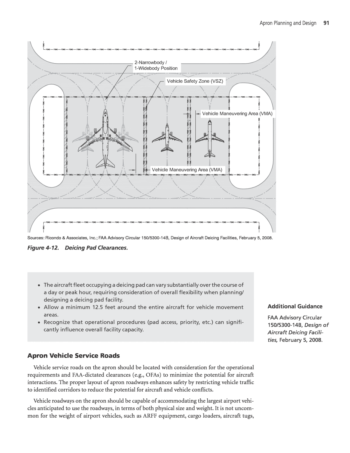
Apron Planning and Design 89 Power-out maneuvers can require more apron area if aircraft turning movement must be accommodated, either at the time of gate entry or at the time of gate exit. Alternatively, some aircraft can power out of an apron or gate parking position by moving in reverse, referred to as a âpower backâ maneuver, although pilot visibility and jet blast can be of concern. Consideration of airline operating procedures and aircraft maneuvering requirements is necessary in planning for power-out operations. Airport planning manuals published by aircraft manufacturers contain information on ground maneuvering of aircraft. These manuals typically provide information on airplane char- acteristics, such as the maximum turning angle or apron size required for power-out maneuvers. When planning for power-out movements, planners should not assume the maximum turn- ing angle because of the stress it imposes on the aircraft nosewheel. A more conservative angle should be assumed to avoid excessive tire wear and to account for tire slippage (coordination with the airlines is the best method for determining the maximum angle to be used in analysis). Software programs that simulate aircraft movements are also available. Planning for power-out areas must also ensure that jet blast does not cause any adverse effects to vehicles, equipment, passengers or workers, or other aircraft on the apron. A power-out maneuver on a terminal apron is illustrated on Figure 4-11. This maneuver can be used for narrowbody and widebody aircraft, but is not prevalent because of concern regarding jet blast and the additional amount of apron space and terminal frontage required to accommodate the turning movements. Power-out maneuvers are common on hold pads located along taxiways or taxilanes. As shown on Figure 4-11, aircraft typically turn onto the pad, maneuver along the taxiway/taxilane, turn toward the taxiway/taxilane, and park at either a 45-degree or 90-degree angle behind the holding position marking. Key Points: ⢠Power-out procedures are most common for GA, regional turboprop, and regional jet aircraft. ⢠There are numerous potential hazards associated with power-out procedures for larger aircraft. ⢠Planning for power-out maneuvers typically requires more space than tug-out positions. ⢠Power-out maneuvers are common practice for hold pads and hardstand gate positions. Deicing Pads The FAA recommends that deicing pads have sufficient OFA, vehicle maneuvering area (VMA) for each parking position, and a vehicle safety zone (VSZ) located between positions, as shown on Figure 4-12. Deicing pad OFAs incorporate the clearances defined for taxilanes and taxiways, depending on the apron location in a nonmovement area or movement area, respectively. VMAs are accommodated by providing a minimum clearance of 12.5 feet around the entire aircraft. OFA clearances are usually sufficient to accommodate 12.5-foot VMAs. OFAs for ADG I and ADG II aircraft may not provide sufficient clearances for VMAs, requiring the space between the VSZ and the wingtip to be greater than the OFA. VSZs are located between parking positions to accommodate deicing vehicles, personnel, and other equipment when aircraft are taxiing into and out of the deicing pad. The FAA recommends a minimum VSZ width of 10 feet.
90 Apron Planning and Design Guidebook Source: Ricondo & Associates, Inc. Figure 4-11. Power-out maneuvers. Deicing pad positions can also be configured to alternately accommodate one widebody or two narrowbody aircraft. In these configurations, two VSZs can be provided outside of the outer wingtips of the narrowbody aircraft to avoid placement of a VSZ on the centerline for the wide- body aircraft, as shown in the left side of Figure 4-12. Key Points: ⢠Identify the size and number of aircraft that may simultaneously utilize a deicing pad based on activity forecasts, peaking characteristics, and the future design day flight schedule, if available.
Apron Planning and Design 91 ⢠The aircraft fleet occupying a deicing pad can vary substantially over the course of a day or peak hour, requiring consideration of overall flexibility when planning/ designing a deicing pad facility. ⢠Allow a minimum 12.5 feet around the entire aircraft for vehicle movement areas. ⢠Recognize that operational procedures (pad access, priority, etc.) can signifi- cantly influence overall facility capacity. Apron Vehicle Service Roads Vehicle service roads on the apron should be located with consideration for the operational requirements and FAA-dictated clearances (e.g., OFAs) to minimize the potential for aircraft interactions. The proper layout of apron roadways enhances safety by restricting vehicle traffic to identified corridors to reduce the potential for aircraft and vehicle conflicts. Vehicle roadways on the apron should be capable of accommodating the largest airport vehi- cles anticipated to use the roadways, in terms of both physical size and weight. It is not uncom- mon for the weight of airport vehicles, such as ARFF equipment, cargo loaders, aircraft tugs, Additional Guidance FAA Advisory Circular 150/5300-14B, Design of Aircraft Deicing Facili- ties, February 5, 2008. Sources: Ricondo & Associates, Inc.; FAA Advisory Circular 150/5300-14B, Design of Aircraft Deicing Facilities, February 5, 2008. Figure 4-12. Deicing Pad Clearances.
92 Apron Planning and Design Guidebook and fuel trucks, to reach or exceed 100,000 pounds gross vehicle weight rating. Although most apron roads are located on pavement designed for aircraft, roadways connected to an apron on pavement not used by aircraft must be capable of accommodating sustained use by this type of equipment without damage or deterioration. In conjunction with terminal planning, planners of head-of-stand roads must consider the required height clearances for the type of vehicles operat- ing on these roadways to prevent damage to the PLB segments that span the roadway. The minimum width of apron vehicle service roads is typically the same as that defined by American Association of State Highway and Transportation Officials guidelines, which identify a minimum width of 12 feet per lane. Apron roadway widths may be increased to accommodate GSE that exceeds this width or vehicles that require larger turning radii, such as fuel trucks, semi-trailer trucks, or buses. During the planning process, planners should coordinate with airport operators and tenants to understand the type, size, and frequency of vehicles operating on the aprons. It is critical to maintain adequate clearance between all parts of a parked aircraft and the nearest edge of an apron service road. Some airports, particularly those with constrained apron areas that cannot be significantly expanded or reconfigured, are challenged to accommodate both parked air- craft and the service road without some limited overlap, as shown on Figure 4-13. In coordination with airlines and the airport operator, it may be possible to configure some aircraft apron parking positions so that limited overhang of the tail of the parked aircraft is acceptable. In this case, specific analysis is required to ensure that ground vehicle heights and aircraft tail heights are appropriately considered. While this apron service road configuration is not desirable, it may present a viable option at airports where space constraints prevent other solutions or aircraft parking configurations. In all cases, a high degree of caution must be exercised by all airfield drivers when operating a vehicle in the vicinity of parked aircraft. All vehicle service roads should be clearly marked with the FAA-recommended âzipper roadway markingâ to ensure that vehicle operators understand and can identify the defined limits of the service road. Non-aircraft servicing vehicles that use the apron may require on-apron parking. These vehi- cles include delivery vehicles, trash removal vehicles, tractor trailers for delivery or snow melting, federal agency (TSA, CBP) vehicles, airport security and operations vehicles, and other contrac- tor vehicles. Coordination with airport staff and apron users is recommended to determine the quantity and preferred location for parking spaces to accommodate these vehicles if they are Source: A.S.S.E.T., LLC. Figure 4-13. Tail overhang of apron vehicle service road.
Apron Planning and Design 93 required to remain in the apron area. Locating these parking spaces close to the terminal build- ing is often preferred, as such location maintains greater distances between the vehicles and maneuvering aircraft, and increases safety and convenience for users of the vehicles by limiting their need to walk in the apron environment to access their vehicles. For aprons that accommodate passenger or employee busing operations, specific dropoff areas should be provided as close as possible to the terminal building to minimize the distance that pas- sengers or personnel have to walk in the apron environment. Bus stops serving secure passengers should be located where direct access to the security area complies with TSA rules, regulations, and procedures. Bus stops for employees allowed access to the secure apron environment should be located such that disembarking employees do not interfere with vehicle or aircraft movements. Roadways for emergency vehicles should be provided where needed. Firefighting personnel may require dedicated roadways to directly access the apron environment in an emergency; park- ing may be prohibited in the vicinity of apron fire hydrants. Key Points: ⢠Design roadways to accommodate the largest vehicles to utilize roadways in terms of weight and width. ⢠As much as possible, avoid service road configurations that require vehicles to pass under any portion of an aircraft. ⢠Consider emergency vehicle access requirements in apron service road planning/ design. PLBs Planning for PLBs requires consideration of many variables, including maximum bridge slope limits in accordance with ADA requirements, PLB operating ranges, aircraft parking positions (location of aircraft and door sill on the apron), and the use of multiple passenger loading bridges. ADA Requirements PLBs must comply with ADA requirements, which limit the maximum slope to 1:12 (8.33 percent) for the segment of the PLB spanning between the terminal and the PLB cab. For plan- ning purposes, this span is typically measured from the tunnel hinge point at the rotunda closest to the building to the center point of the cab where the sloped tunnel section ends. ADA slope limits can be one of the biggest challenges in PLB planning, particularly in planning for aircraft that have relatively low loading door sill heights and apron depths that limit how far back the aircraft can be positioned without extending beyond the parking limit line. Operating Ranges Several models of PLBs are manufactured, and they provide varying operating ranges to accom- modate a range of aircraft sizes and apron layouts. Fixed PLBs can generally move in two directions, with a tunneled section that can be extended and retracted as well as raised and lowered. Apron drive PLBs are capable of the same vertical and horizontal movements, but can also be rotated about a rotunda near the building face and have a rotating cab at the far end of the PLB. Apron drive PLBs are able to accommodate a larger range of aircraft by providing a greater range of movement. PLB operating ranges vary with the bridge model, most notably relating to whether it is a two-tunnel or three-tunnel version. As shown on Figure 4-14, apron drive PLBs are typically
94 Apron Planning and Design Guidebook Figure 4-14. PLB operating ranges. Source: Ricondo & Associates, Inc.
Apron Planning and Design 95 configured with two or three telescoping tunnels that have minimum and maximum operating ranges. The PLB operating range reflects the difference between the fully extended PLB and the fully retracted PLB. The range of swing for the rotunda is limited and the cab has rotational limits. The oper- ating range of a PLB can be electronically or mechanically limited to prevent the equipment from being used in a manner or configuration that could cause damage. Many airports in areas prone to hurricanes require apron drive PLBs to be stowed against the face of the building as part of hurricane preparations. Alternatively, anchors can be installed in the apron pavement to secure PLBs during these events. Fixed PLBs typically have a horizontal operating range reflect- ing the extension of a tunnel and a vertical operating range reflecting the raising or lowering of the tunnel. Typically, the PLB rotunda is attached to a terminal or concourse building by a short fixed segment. The PLB rotunda can also be attached to a long fixed PLB segment if the aircraft park- ing position is located reasonably far from the building. Fixed PLB segments can also be used to raise or lower the rotunda floor height to help meet ADA slope criteria. If the PLB is already installed, the operating ranges and slope limits are used to define possible aircraft parking layouts. If a PLB has not yet been installed, the aircraft parking position on the apron will be limited by the operating ranges of the PLB models under consideration, the door sill heights of aircraft that may occupy the parking position, and general pavement slopes in the apron area. Aircraft Parking Positions Planning for PLBs on an apron also requires consideration of the aircraft fleet mix to be accommodated at the parking position. Fleet mix data can be obtained from airport staff, the airline occupying the gate, or other relevant stakeholders. Consideration of aircraft types that may use specific parking positions or aprons in the future should be incorporated into planning for PLB equipment on an apron. Aircraft with low door sill heights, such as regional jets, usually need to be parked farther away from the rotunda so the bridge can slope downward and stay within ADA slope limit require- ments. Conversely, aircraft with high door sill heights may also need to be parked away from the rotunda so the bridge can slope upward and remain in compliance with ADA requirements. Generally, the retracted (i.e., minimum) length of a bridge is slightly greater than one-half or one-third of its fully extended length depending on whether the bridge consists of two or three telescoping tunnel segments. Planning for PLBs should also consider any special ramps needed for regional jets, turboprop aircraft or aircraft that require PLBs to be positioned lower than the aircraft door sill. To plan for accommodating a wide range of aircraft, the needs of the smallest aircraft must be balanced with the needs of large aircraft that typically have higher door sill heights and need to be parked closer to the terminal building to avoid the tail extending beyond the apron park- ing limit. The greatest flexibility in accommodating a range of aircraft is achieved by increasing apron depth if space is available. Greater apron depth typically allows longer and larger aircraft to occupy a gate while also providing sufficient space for smaller aircraft to be positioned farther from the gate to meet ADA slope limit requirements for the PLB, assuming that the aircraft is positioned within the operating limits of the PLB. Figure 4-15 provides a simplified example to plan for an apron drive PLB. Using AutoCAD or a similar program allows planners to test the capability of a particular PLB to serve multiple aircraft at a given parking position. Specialized computer programs are also available to assist with PLB planning.
96 Apron Planning and Design Guidebook Assuming that an apron adjacent to a terminal that has a second-level floor height 12.0 feet above the apron needs to accommodate four aircraft with the corresponding door sill heights: ⢠Boeing 737-700: 8.50 feet ⢠MD-80: 7.30 feet ⢠CRJ-900: 6.28 feet ⢠CRJ-200: 5.00 feet The range of PLB capability needed to accommodate these aircraft must be calculated. To determine the length of the PLB needed to accommodate the door sill height for the range of aircraft listed, use the following calculation: Required Bridge Length Building Floor Height Aircraft Door Sill Height Required Maximum Slope Percentage Apron Slope = â â The required maximum slope is 8.33 percent (1:12) to comply with the ADA. A terminal apron typically slopes away from the terminal building at a minimum of 1 percent for the first 50 feet and at a minimum of 0.5 percent beyond 50 feet to meet National Fire Pro- tection Association (NFPA) requirements (see Section 4.2.1). For the example below, a 1 percent consistent apron slope was assumed. Required Bridge Length for Boeing 737-700 12.0 8.50 8.33% 1% feet47.75= â â = Required Bridge Length for Boeing MD-80 12.0 7.30 8.33% 1% feet64.12= â â = Source: Ricondo & Associates, Inc. Figure 4-15. PLB planning example.
Apron Planning and Design 97 Required Bridge Length for CRJ-900 12.0 6.280 8.33% 1% feet78.04= â â = Required Bridge Length for CRJ-200 12.0 5.00 8.33% 1% feet95.50= â â = The required PLB length ranges from 47.75 feet to 95.50 feet. After determining the necessary operating lengths, the aircraft parking plan should be configured to ensure that the apron depth is sufficient to accommodate the aircraft tail farthest from the gate at the same time that the loading door is positioned at the point used to analyze PLB length requirements. Using the calculated oper- ating ranges, a PLB model can be selected to achieve the aircraft parking and servicing requirements. Multiple PLBs The use of multiple PLBs to serve a single aircraft, as shown on Figure 4-16, requires con- sideration in planning the apron area and the interior of the terminal/concourse to ensure that the PLB attachment points and supporting holdrooms are appropriately located in relation to the aircraft parking position. Multiple bridges can be used to serve a single widebody aircraft or to serve two narrowbody aircraft within approximately the same gate envelope. Consideration must be given to accommodating the PLB operating ranges for both aircraft parking configura- tions. The methodology for determining the required PLB length is the same as if the position was served by a single PLB except that the length requirements must be calculated from the rotunda location and assumed elevation (which may differ from the terminal floor elevation), and which may be some distance from the terminal face if a fixed bridge segment is used. Key Points: ⢠Identify types of PLBs to be utilized for specific airlines and aircraft operations. ⢠Planning/design must take into account loading and unloading of new genera- tion large aircraft. ⢠PLBs can have a significant influence on apron/gate planning, particularly around the ends of pier concourses and along concourses. ⢠As much as possible, incorporate flexibility into PLB/apron planning to enhance the likelihood of accommodating fleet changes. Source: Ricondo & Associates, Inc. Figure 4-16. Multiple PLBs.
98 Apron Planning and Design Guidebook GSE Staging and Storage Planning to accommodate the staging and storage of GSE contributes to a safer apron environ- ment by ensuring that equipment not in use is positioned in areas that reduce the potential for aircraft and vehicle interaction. GSE staging areas are used to pre-position equipment in advance of an aircraft arrival. These areas are generally located adjacent to each apron parking position. GSE storage areas are used to park GSE when not in use. These areas are often located on the apron in close proximity to aircraft parking positions, but outside the aircraft service envelope. The position of aircraft parked on an apron typically provides large areas in front of its wings that are used for GSE storage and maneuvering. An apron can be configured with additional depth or wingspan clearance to increase the area for GSE storage and maneuvering. It is impor- tant to recognize that the GSE storage areas configured in proximity to the aircraft parking positions often have a shape and size (narrow and deep) that may not allow efficient access to stored/parked equipment/vehicles. In these cases, available gate-area GSE storage area may not be used as effectively as storage areas remote from the gate environment that are less limited by the aircraft service envelope, PLB operating zones, and building clearances/access. Larger aggregate GSE storage requirements are usually accommodated in a separate area in close proximity to the apron. It is not unusual for GSE storage requirements to exceed the avail- able area around parked aircraft. In such cases, GSE may have to be stored in areas that, while not immediately adjacent to the aircraft gates, are sufficiently close that operating efficiency is not significantly affected. In assessing the amount of GSE storage space that may be required, an inventory of mobile equip- ment is necessary. Depending on the use of that equipment (number of flights served per day/night), it is possible that some GSE will always remain in service or be staged at gates awaiting arriving air- craft. Airports with a notable fleet of electric-powered vehicles (e.g., baggage tugs) may utilize space on the apron for charging stations for these vehicles, although these stations are also accommodated in lower level terminal/concourse space so that they are under cover. This space may occupy a large footprint to accommodate multiple charging stations and the ability to independently maneuver GSE into and out of the station. Stakeholder input is important in sizing GSE storage areas to ensure an understanding of the operational characteristics that may influence GSE use. Many aircraft parking positions rely on a combination of fixed and mobile GSE. Examples of fixed GSE include mounted preconditioned air units, GPUs, and potable water supply cabinets. The use of fixed equipment reduces congestion around the aircraft parking position by elimi- nating additional stand-alone carts or vehicles. The following subsections describe the methods used in planning for GSE staging and storage areas for air carrier, cargo, and general aviation aircraft operations on the apron. Key Points: ⢠Recognize that GSE storage can impose significant space demands in the apron environment. ⢠Understand the types and sizes of GSE that are in use at a particular facility when planning/designing an apron. ⢠Communicate with airlines and airport users to identify the types and amount of GSE that is required in the vicinity of the gates to support operations. Air Carrier Aircraft Air carrier aircraft are typically serviced while parked on an apron. Air carrier aircraft gener- ally require baggage handling, refueling, galley servicing, lavatory servicing, and cabin cleaning.
Apron Planning and Design 99 Many GSE vehicles and fixed equipment may be used to service an aircraft simultaneously, as shown on Figure 4-17. All or some of these vehicles may be used depending on available fixed equipment, such as PCA units, GPUs, and existing hydrant fueling systems, and whether or not the APUs on aircraft are used. When a gate or parking position is unoccupied, GSE staging areas should be provided around each aircraft parking position where possible. The staging areas allow for the pre-positioning of necessary GSE so that the aircraft can be promptly serviced upon arrival at the gate. As shown on Figure 4-18, GSE staging areas are typically provided outside of aircraft safety envelopes to be clear of aircraft appurtenances, such as wing-mounted engines and wingtips/wingtip devices. Some equipment may be safely staged within the safety envelope if it remains clear of aircraft during maneuvers into or out of the parking position. For example, Figure 4-18 shows a hydrant fueling cart staged within the aircraft safety envelope. The height of this equipment is sufficiently low and with it being secured to the apron, an aircraft can taxi into position without contact- ing the cart; however, personnel would not be allowed inside the aircraft safety envelope during the aircraft entry maneuver. Spatial requirements for GSE staging depend on the quantities and types of GSE needed, which can vary according to the size of aircraft and type of operation (domestic or international), passenger loading method, and airline operating preferences. During nonpeak times or when certain types of mobile GSE are not required, it may be more practical and safer to store the mobile equipment away from the gate staging areas. Storage areas should be provided for airline GSE that is not in use or less frequently used. It may be possible to have a shared storage area for a group of gates shared by one airline, instead of individual storage Figure 4-17. Representative aircraft servicing equipment. (continued on next page)
100 Apron Planning and Design Guidebook Source: Ricondo & Associates, Inc.; The Boeing Company, 747-400 Airplane Characteristics for Airport Planning, December 2002; Airbus S.A.S., A321 Aircraft Characteristics Airport and Maintenance Planning, June 1, 2012. Figure 4-17. (Continued) Source: Google Earth Pro. Figure 4-18. GSE staging areas.
Apron Planning and Design 101 areas for each gate. As shown on Figure 4-19, these areas can be located adjacent to gates or in a separate area in close proximity to the apron. Remote storage locations help to keep the apron locations free of clutter, but these locations should not be so remote that it takes excessive time to reach the parking positions. In planning for these storage areas, the installation of physical barriers should be considered to prevent stored equipment from rolling away and to protect the equipment from jet blast exposure. The size of the storage areas is also dependent on the types and quantities of equipment to be stored, which should reflect airline input. Source: Google Earth Pro. Figure 4-19. GSE storage areas.
102 Apron Planning and Design Guidebook As planning for apron GSE staging and storage is largely driven by the equipment used by individual airlines, an inventory of GSE should be prepared through coordination with the operating airlines. Information on the aircraft service methods used on the apron is helpful. An inventory checklist outlining the items that should be considered for air carrier aircraft GSE staging is provided in Appendix A. Use of this checklist allows planners to conduct a detailed analysis of the GSE and aircraft service methods to be used, if warranted by the specific project. After this inventory is completed, the apron can be drawn with proper locations for staging and storage of GSE. Many GSE staging and storage areas are marked (on the pavement) to keep the apron organized and maximize the utility of the parking/storage area. Key Points: ⢠GSE in use may vary significantly among airlines. Gather as much airline-specific information on GSE as possible when planning/designing equipment storage areas. ⢠Ensure that adequate GSE storage areas are included to support apron facilities to minimize the potential for equipment to be parked or stored in areas that may create safety or operational impacts. Cargo Aircraft Much of the GSE used to service cargo aircraft is similar to that used to service passenger air carrier aircraft, with the addition of cargo-specific loading equipment. Mobile stairs, GPUs, and cargo loading platforms are usually static and are not moved between parking positions. Cargo container loading vehicles, container tugs, and dollies are used to support all parking positions and usually staged near the parking area, as shown on Figure 4-20. Source: Google Earth Pro. Figure 4-20. Cargo GSE staging and storage.
Apron Planning and Design 103 Cargo operators also have a large amount of transport and loading equipment that is not in use throughout the day. Storage areas on and adjacent to cargo aircraft aprons should be provided for this equipment when not in use. The most space-intensive demand for cargo GSE storage is for cargo containers and dollies. This equipment is used upon aircraft arrival, during unloading and unpacking, and prior to aircraft departure for container packing and loading. Similar to planning air carrier aprons, the cargo apron planning process should include an inventory of GSE used in the specific userâs cargo operation as detailed as warranted by the specific project, including determination of the aircraft fleet and cargo container sizes, types, and quanti- ties. An inventory checklist outlining the items that should be considered for cargo GSE storage is provided in Appendix A1. This information can be used for apron layout, identification of proper storage locations, and appropriate markings. It is important to consider space for maneuvering by container lift vehicles and cargo dolly trains. Storage areas need to be configured for person- nel to walk among equipment, maneuver in and out of position, and be protected from jet blast. Key Points: ⢠Recognize that all cargo aircraft operations generally require different types of ground service equipment and often require a greater quantity of equipment depending on cargo airlinesâ procedures for collecting, sorting, and staging out- bound cargo. ⢠Due to the peaked nature of many all-cargo operations, it is critical to ensure that there is adequate GSE storage and staging areas, as well as service roads that support GSE movements in and around the cargo area. General Aviation Aircraft General aviation facilities are typically operated by FBOs that provide ground support services, commonly referred to as line services, which are generally the same types of services required for air carrier aircraft, but typically on a smaller scale. However, it is important to recognize that even widebody aircraft can be considered general aviation aircraft depending on the operator/operation. As most general aviation aprons do not have marked parking positions to allow for flexible parking layouts (the fleet mix can vary substantially at a general aviation facility), GSE staging and storage do not typically occur adjacent to aircraft parking positions. It is not common for GSE to be pre-staged in advance of the arrival of a general aviation aircraft, except in the case of large air- craft (e.g., sports team charter, dignitaries). As shown on Figure 4-21, GSE storage areas on general aviation aprons are most often delineated areas at the edge of the apron, close to the terminal or maintenance buildings. This location provides servicing technicians with quick access to equip- ment, such as tow tractors, GPUs, fuel trucks, and follow-me vehicles. Follow-me vehicles are used by FBOs to guide general aviation aircraft to aprons. The staging area should be located to avoid obstructing passengers and pilots that may be walking to/from the terminal. The GSE can then be driven or towed, as needed, to the aircraft that requires ground support services. Usually, one co- located staging and storage location is used given the relatively small size of general aviation aprons. An inventory checklist outlining the items that should be considered for general aviation GSE staging and storage is provided in Appendix A. Similar to planning for other aprons, the planning process for general aviation aprons should include an inventory of GSE required by apron users, including vehicles, and an inventory of the services provided by an FBO operating a general avia- tion apron. This information can be used to configure the apron, identifying appropriate storage and staging locations and marking them or identifying the general areas accordingly.
104 Apron Planning and Design Guidebook Key Points: ⢠It is critical to understand the specific line services offered by FBOs or other GA apron operators in order to plan for the necessary equipment. ⢠GA aprons can accommodate an extensive range of aircraft, which can have widely varying GSE/line service needs. Pavement Markings/In-Pavement Lighting Pavement markings and in-pavement lighting provide visual guidance to pilots maneuvering in apron areas, as well as into and out of specific parking positions or gates. The markings also aid ground crew personnel in accurately positioning aircraft for servicing and in enhancing safety by demarcating areas that must remain clear of personnel and equipment to avoid conflict with aircraft operations or servicing and to protect the safety of personnel, equipment, and aircraft. The following subsections describe apron-related FAA airfield markings and apron markings. Apron-Related Airfield Markings The FAA publishes marking guidelines for airfield elements, including those associated with or adjacent to aprons: taxiways and taxilanes, holding positions, nonmovement area boundaries, and roadways. Figure 4-22 identifies markings standardized by the FAA for airfield components, as discussed in the text that follows. Source: Google Earth Pro. Figure 4-21. General aviation GSE storage area.
Apron Planning and Design 105 Taxilanes and Taxiways. All taxilanes and taxiways have a centerline marking that provides pilots with continuous visual guidance along a designated path. A taxilane/taxiway centerline marking consists of a yellow line, which is bordered in black when the taxiway is part of a Surface Movement Guidance and Control System (SMGCS) route. At some airports, a color marking may be added adjacent to a taxilane marking to help aircraft operators more easily identify spe- cific taxilanes on aprons with multiple apron taxiways and taxilanes. Sources: Ricondo & Associates, Inc.; FAA Advisory Circular 150/5340-1K, Standards for Airport Marking, September 3, 2010. Figure 4-22. Apron-related airfield markings.
106 Apron Planning and Design Guidebook Taxiway centerline lights provide enhanced visual guidance to pilots in the area between a runway and an apron area and operating on the apron. Taxiway lights are not required, but are installed where other lighting may cause confusion for pilots taxiing or parking aircraft or to improve guidance to aircraft parking positions. These lights are green and offset from the cen- terline by approximately 2 feet. Holding Positions. Holding position markings are used on taxiways and aprons to identify critical areas associated with runways, navigational aids, and RPZs. Different types of holding posi- tion markings are used for different purposes. Runway holding position markings are used on taxi- ways to hold aircraft short of an active runway and are placed at or beyond the RSA. These markings consist of two solid lines parallel with two sets of dashed lines. ILS holding position markings are used on taxiways to delineate the edges of critical areas and the POFZ that aircraft must remain clear of until directed otherwise. Intermediate holding position markings are most typically used by ATC to hold aircraft at taxiway-taxiway intersections in congested areas or on aprons in move- ment areas. The markings are yellow and consist of the pattern shown on Figure 4-22. Nonmovement Area Boundaries. Nonmovement area boundaries are used to delineate movement areas under the control of the ATCT controller from nonmovement areas that are not under ATCT control (although aircraft may be under the control of ramp tower controllers when in nonmovement areas). The FAA recommends that a letter of agreement should be for- malized between the airport operator and FAA ATC to specify the location of these markings. Roadways. Vehicle roadway markings are used to delineate roadways located on or crossing aprons or airfield components. The markings are intended to reduce the risk of aircraft and vehi- cle interactions by channelizing vehicle movements, providing traffic guidance (signed or painted on pavement), and facilitating driver awareness of aircraft operating areas. Vehicle roadway mark- ings consist of three components: roadway edge lines, centerlines, and stop lines. Roadway edge markings can be either solid white lines or zipper-style markings where roadway edges would benefit from enhanced delineation. Zipper-style markings enhance visual awareness for both vehicle operators and aircraft pilots. A dashed line is used to delineate the centerline separating the roadway lanes. Stop lines or stop bars are used at junctions with other roadways and at the fixed or movable object line when the roadway crosses a taxiway or taxilane. Vehicle roadway markings and stop bars are typically painted white. Supplemental markings that identify stop bars with the letters âSTOPâ or other roadway functions, such as a fire lane or restricted roads, may also be used. Apron Markings Consideration must be given to the clarity and density of apron markings in terminal and cargo areas to avoid visual confusion for both ground crews and pilots. The efficiency of apron areas can be greatly influenced by the amount of and type of markings. Given that the FAA usu- ally does not control aircraft activity on aprons and does not currently publish guidance related to markings in the leased portions of the apron, planning for apron markings, other than airfield markings that are required by the FAA, is a site-specific activity. The Airports Council Interna- tional (ACI), International Air Transport Association (IATA), ICAO, and Airlines for America (A4A, formerly known as the Air Transport Association of America) all publish apron marking guidelines; however, the application of these guidelines should reflect strong coordination with users, particularly at air carrier gates. Apron markings can vary greatly among airports and can even vary among aprons and park- ing positions at a single airport. Contributing to this is that airports typically have responsibility for marking the areas of the ramp that are commonly used by operators (e.g., taxiways, taxilanes, vehicle service roads, air traffic hand-off points, etc.) to ensure that appropriate FAA standards are incorporated. However, the FAA does not have marking standards for the leased, nonmove- ment portions of aprons.
Apron Planning and Design 107 The operator or airline exclusively leasing an apron area or parking position(s) often uses its own marking standards that were developed and implemented to support its specific opera- tions and practices. The application of an airlineâs specific marking standards allows that airline to maximize the utility and efficiency of the leased area, consistent with the safety priorities of that airline. This can be of particular benefit for airlines that have a hub operation or substantial activity at a particular airport, and/or at terminal facilities that are notably dated relative to cur- rent planning criteria. As aircraft have evolved and as airlines have changed the aircraft in their collective fleets, airlines have been challenged at some airports to efficiently accommodate those changes within the limits of existing airfield elements, aprons, and terminals/gates. Optimized use of an airlineâs apron, particularly when it cannot be expanded or significantly altered, can require that airline to configure aircraft parking differently than would occur if additional area/ depth were available. In these cases, the marking plans reflect the apron-specific aircraft parking and servicing challenges and may differ from those in use by that airline at other airports and from those in use by other airlines at that airport. Apron markings in exclusively leased areas may not be standardized among airports, but rather reflect the airport-specific challenges and constraints, as well as the operational requirements of the airline. Facilities shared by multiple users are often marked in a more standardized manner, typically following standards developed by the airport operator. These standards may result in a less effi- cient apron operation due to the need to operationally accommodate a more diverse group of users/equipment and to provide an acceptable level of safety (i.e., clearances, service envelopes, etc.) for the largest aircraft that could occupy the facility. For example, an aircraft gate exclusively leased to an airline may reflect that airlineâs own marking standards while a common-use air- craft gate, available to multiple airlines, will be marked according to airport operator standards to provide commonality and consistency among gate markings, irrespective of which gate an airline would be assigned to use. The level of responsibility by airport operators for marking aprons ranges from allowing lessees full control of apron marking to enforcing airport-generated marking standards. At a minimum, airport operators will require approval of marking plans for parking positions between leaseholds. It is recommended that when an apron lease expires, the apron markings are revised to reflect airport marking standards in case the apron is needed while not leased. In instances in which a leased gate is returned to the airport operator and not immediately leased to another airline, the apron markings utilized by the prior tenant should be reviewed in the context of potential uses and fleet. An airport-controlled gate may be used as temporary overflow aircraft parking, utilized to accommodate irregular or diverted operations, store GSE, and other potential uses. At the time the gate is returned, a determination should be made whether remarking is required to ensure that the apron area can safely accommodate anticipated or potential uses. The types of markings used on aprons also vary depending on the type of operation and the size of the apron available. On general aviation aprons, fewer aircraft-specific markings are generally required to preserve the flexibility of the apron. Similarly, the more diverse the uses of a particular apron (overnight parking, aircraft deicing, hold pads, remote hardstand/ground loading), the more challenging it is to define a marking plan that accommodates the desired flex- ibility but does not become sufficiently prescriptive that operational efficiency or effectiveness is compromised. In these cases, the best marking plan is achieved with input from the users, the airport, and the FAA (particularly for facilities in the movement area). The following paragraphs describe the markings and in-pavement lighting typically present on aprons and the locations where in-pavement lighting is frequently used. The different types of markings and variations used on aprons are presented for informational purposes; prior to developing an apron marking plan, planners should coordinate with airport users and man- agement and consider the operational environment at the airport. Figures 4-23 through 4-25 illustrate various configurations of the markings.
Figure 4-23. Terminal area markings: (a) narrowbody aircraft and (b) widebody aircraft. Source: Ricondo & Associates, Inc. (a) (b)
Source: Ricondo & Associates, Inc. Figure 4-24. Terminal gate markings. Source: Ricondo & Associates, Inc. Figure 4-25. Cargo apron markings.
110 Apron Planning and Design Guidebook Lead-in/Lead-out Lines. Lead-in and lead-out lines are gate-specific pavement markings that allow an aircraft to taxi under its own power or to be towed into a gate or aircraft parking position. When used in combination with aircraft safety envelopes, these lines provide necessary clearances from vehicles and equipment in the gate area. These lines are typically yellow and the same width as the taxiway/taxilane centerlines, but in certain instances, a lead-in line for a specific aircraft is identified by a different color. Lead-in/lead-out lines are outlined in black when necessary to provide contrast for light-colored pavement, such as concrete. More than a single lead-in line is possible at a parking position to accommodate a wider range of aircraft. In these cases, the centerlines are labeled to identify gate or position numbers (e.g., 29 and 29A), maximum wing span (e.g., MAX SPAN 118 FEET), or specific aircraft models (e.g., 747). A4A recommends that 24-inch letters be used to identify parking position or gate numbers. Stop Lines. Nosewheel stopping points along a parking centerline are typically labeled by aircraft type (B-737, DC-9, etc.) and are provided to aid aircraft marshallers and aircraft tug drivers in positioning aircraft so that PLBs can accurately approach and be connected to the aircraft. Some airport operators implement a marking system in which stop lines are labeled with letters or numbers (e.g., A, B, C, D or 1, 2, 3, 4) that correspond with signage at the head of the gate that identifies the corresponding aircraft for each stop (e.g., A: 737, B: 757, C: A320). A4A recommends that 12-inch letters be used to identify nosewheel stopping positions. Deic- ing, holding, and RON aprons with lead-in lines often incorporate stop lines to ensure that the aircraft remains outside of any critical areas, such as OFAs. Aircraft Safety Envelopes. Aircraft safety envelopes define the areas where no vehicles or GSE should be positioned unless they are specifically servicing the aircraft occupying that par- ticular gate. The area outside of the aircraft parking and service envelopes and outside of the PLB operational ranges, up to the building face, can be used for GSE parking and storage and other apron activities. The envelopes should accommodate a safety zone around jet engine intakes to avoid adverse engine suction on personnel and equipment. Aircraft manufacturers provide information on the recommended safety zones around engines when idling. These markings are typically solid red bordered in white to provide additional contrast between the marking and the pavement. Many cargo operators use only white markings to identify the aircraft safety envelope. A4A recommends 10 feet as the minimum distance that the safety envelopes should protect from any point on the aircraft. Passenger Walkways. Markings are used on aprons to identify designated passenger walk- ways between ground-loaded aircraft and a terminal or concourse building. These markings are typically outlined in white with a white cross hatch. Passenger walkways should be configured to protect passengers from maneuvering/moving aircraft, aircraft engine intake zones/propeller safety areas, and ground vehicle movements, while also ensuring that ground personnel are able to effectively monitor and direct passengers to the intended aircraft without compromising safety or security. Passenger walkway marking plans should be reviewed with users to ensure that the proposed walkway configurations meet all safety and security needs. Equipment Parking. At many airports, although not all, equipment parking lines are used to identify areas outside of the aircraft safety envelopes and the loading bridge operating ranges that can be used to stage or store GSE. These markings consist of a solid white outline that is usually rectangular and sized either for one piece of equipment or that may consist of one outline for parking multiple pieces of GSE. The only equipment that is typically allowed to park inside of the aircraft safety envelope is fuel hydrant carts. PLB Operating Area. The area under and around passenger loading bridges must be kept free of vehicles, GSE, other equipment, material storage, and any other obstacles that could
Apron Planning and Design 111 impede the range and safe maneuvering of PLBs. The markings should define the full opera- tional range of the PLB necessary to accommodate the aircraft fleet serviced at the PLB. The operating area should also encompass all bridge appurtenances, such as baggage slides or eleva- tors or attached equipment. This operating area is considered a no parking zone and is marked as such, by a red outline and red crosshatching oriented 45 degrees to the lead-in line. A solid white circle, outlined in red, is often used to identify a âhomeâ position where a PLB is stored when not in use. Fuel Hydrants. Fuel hydrant markings identify fuel system connections located on the apron. The markings for these vary, with airport operators using red or yellow boxes, centered on the in-pavement hydrant fuel pit connection, to identify their locations. The same markings can also be used to identify underground fuel ports for GPU and PCA connections. Text painted on the pavement may accompany these markings with the words âFuelâ or âNo Parking.â Engine Inlet/Propeller Hazard Zones. In addition to engine exhaust jet blast, consider- ation and recognition of engine inlet and propeller hazard zones are critical to the safety of apron operations. Running aircraft engines generate sufficient suction to ingest unsecured equipment, materials, or people if not kept clear of the engine intake/ingestion areas. Propel- ler aircraft also create suction that can pull people or equipment into the propellers. Pavement markings can be used to define these hazards zones, which must be maintained clear of person- nel, equipment, and materials. Pavement markings can also be used to define the area within which it is safe to approach a stationary aircraft that has engines running. Aircraft and engine manufacturers are the most accurate sources of dimensional information on engine inlet and propeller hazard zones. These areas can have a radius of up to 30 feet for some aircraft and engine models. No Parking/No Driving Zones. No parking and no driving zones prohibit the parking or operation of vehicles and equipment in the marked areas. The markings encompass the no parking/no driving zones by a red line with red crosshatching within that is oriented 45 degrees to the aircraft lead-in line. This type of marking is used for multiple purposes, all of which are intended to keep vehicles, personnel, and equipment clear of specific areas, including PLB oper- ating areas and engine intake and propeller hazard zones, and to provide building emergency access. No parking zones provide clear and expedient emergency access to fire hydrants and building firefighting systems and controls. Some aircraft and airport operators use no driving zones parallel to lead-in lines to keep GSE vehicles from driving under aircraft. These no drive zones are often painted white to minimize pilot confusion. No drive zones for PLB operating areas should be placed so that all equipment on the PLB (e.g., stairways, baggage slides and lifts) is contained in this area. Engine Startup Positions. Apron markings are sometimes used to identify locations or boundaries that aircraft must be pulled to by an aircraft tow tractor before engine start can be initiated or breakaway thrust can be used. Fueling Restriction Lines. Fueling restriction lines are used to identify areas adjacent to a building where fueling activities are not permitted in accordance with NFPA 415, Standard on Airport Terminal Buildings, Fueling Ramp Drainage, and Loading Walkways. These markings may be used on aprons without hydrant fueling systems to ensure that fueling activities do not occur near buildings. There is currently no industry guidance related to marking fuel restriction lines. Some aprons may include markings that designate smoking areas for apron workers. Provid- ing for these areas may enhance safety by ensuring that smoking does not occur near fueling activities or in other inappropriate areas.
112 Apron Planning and Design Guidebook Key Points: ⢠Incorporate specific types, designs, and colors of apron markings considering the specific user of the apron or gate area. ⢠Clearly identify all critical aircraft hazard locations that could endanger person- nel or equipment. ⢠Coordinate all proposed apron/gate markings and labels with the ultimate user of the specific gate or apron area. ⢠Recognize the potential for confusion when there is significant density and types of apron markings. ⢠Clearly depict all areas that must remain clear of all equipment and vehicles for safety reasons and/or to ensure unencumbered access by emergency vehicles and equipment. Signage Apron signage is an important means by which information and instructions can be commu- nicated to pilots and others on the airfield. The FAA requires airport operators to develop sig- nage plans that incorporate mandatory instructions, location, boundary, direction, destination, roadways, and information signs (e.g., radio frequencies, noise abatement procedures). These plans can extend to apron areas, particularly the movement area that extends into a portion of the apron. Elevated airfield signs are limited on aprons (generally fitting only on-apron entrances and exits) because parked aircraft limit visibility of the signage, aircraft movements on aprons are not channeled as much as they are on taxiways/taxilanes, and flexibility in aircraft movements and parking is critical. Many of these signs are used at the apron edges to identify taxiways or taxilanes, holding positions, safety areas, OFZs, ILS critical areas, and runway approaches. Sig- nage may also be used to identify apron entrances, apron destinations (such as hold and deicing areas), passenger and FBO terminals, engine run-up areas, compass calibration pads, and fueling facilities. In addition, signs that warn pilots of the end of a taxilane or edge of pavement are used. In the terminal area, gate signage assists pilots in locating gates and is often located on the terminal/concourse face or on the cab of a PLB. Internally lighted gate signage is recommended as it increases visibility during nighttime hours or low visibility conditions. Airport operators or hub airlines often use dynamic signage on terminal aprons, known as ramp information display sys- tems that provide information to airline and ramp personnel. These systems often display flight numbers, destinations, scheduled times, and time remaining for aircraft departure and arrival. Building-mounted signs typically define the function of a building or identify the entrances to a building, such as FBO and CBP facilities. On general aviation aprons, building signage is used to identify service operators and advertise their business name and services available. Fuel- ing areas are often signed with the fuel vendorâs brand, type, and cost. Figure 4-26 shows several examples of signs used on-apron facilities. Surface-painted or thermoplastic-applied signs are used where elevated signs are prohibited or not practical and to reinforce elevated signs at critical locations. On aprons, these are generally limited to defining parking spots in conjunction with apron markings. Truck-mounted signs are often used for follow-me vehicles used during SMGCS operations or by FBOs to guide unfamiliar pilots to their facilities. Additional Guidance FAA Advisory Circular 150/5340-1K, Standards for Airport Marking, September 3, 2010. Airlines for America, SG 908: Recommended Apron Markings and Identifications, 2010. ACI, Apron Markings and Signs Handbook, 2007.
Apron Planning and Design 113 Key Points: ⢠Due to the expansive and flexible nature of aprons, it is often difficult to install apron-level signage, emphasizing the need for clear and unambiguous pave- ment markings. ⢠Apron signage to be designed for adequate visibility from numerous locations around an apron area. Lines of Sight Aprons are often controlled by personnel in either an ATCT or a ramp tower. Where these towers are used, it is critical to ensure a clear line-of-sight to aprons. ATCT The FAA advises that controllers in an ATCT cab must have an unobstructed view of all con- trolled movement areas. Although it is desirable to have the ability to view all pavement surfaces (edge to edge), it may be sufficient to view only pavement centerlines where a clear view of an aircraft on that centerline is possible. The FAA also sets visibility requirements for object dis- crimination, which is a quantitative assessment based on observation range, ATCT height, and atmospheric and surface conditions. Angle of incidence is another criterion used by the FAA to Additional Guidance FAA Advisory Circular 150/5340-18F, Standards for Airport Sign Sys- tems, August 16, 2010. Source: Ricondo & Associates, Inc. (a) (c) (d) (b) Figure 4-26. Apron signage: (a) informational sign; (b) runway approach sign; (c) no entry sign; and (d) gate signage.
114 Apron Planning and Design Guidebook assess an observerâs viewing perspective of movement areas. For general planning purposes, the angle of incidence for line-of-sight (or the angle of the sight line to the ground at the location of the airfield component) should be equal to or greater than 0.80 degree. ATCT controllers should have the ability to clearly view aircraft entering movement areas or aircraft pushing back into movement areas from aprons. Many aprons are located in or adjacent to movement areas, making it necessary to consider line-of-sight when planning apron facilities. Such consideration includes ensuring that aircraft parked on a new apron will not cause line-of- sight shadows to movement areas, particularly when considering tail heights. Key Points: ⢠Design of apron areas must permit unobstructed visibility from the ATCT or air- line ramp tower. ⢠FAA air traffic controllers must have unobstructed visibility of any hand-off points at which aircraft exiting an apron area transition to the movement area. Ramp Tower Maintaining a clear line-of-sight from a ramp tower is desirable to ensure that aircraft can be moved safely into and out of aprons, including gates and deicing positions. A clear line-of-sight is especially desirable for terminal gates where many aircraft and vehicle movements occur simul- taneously. In areas where the unobstructed view of an apron from a ramp tower is not possible, CCTV has been used to provide supplemental viewing from the ramp tower when coordinated and approved by all tower users and aircraft operators. The FAA has not published specific criteria for the siting (location) or height of ramp towers. In a terminal area, ramp towers should be sufficiently tall to provide an unobstructed view over the tails of aircraft parked on the terminal or cargo ramps to enable identification of any aircraft taxiing on the most inboard taxilane. Although it is most desirable to view all areas of an apron or taxilane, in cases where this is not possible, the ability to view the fuselage of an aircraft should be maintained at a minimum. Given the range of aircraft sizes, understanding the aircraft fleet projected to use the apron is critical. Planning for a ramp tower or apron should provide for the ability to view the smallest aircraft in the projected fleet over the tails of the largest aircraft in the fleet. Figures 4-27 and 4-28 illustrate the general calculations used to determine the necessary eye height for a tower or to determine if a tower provides an unobstructed view of a planned apron. Eye height is usually assumed to be approximately 5 feet above the floor of the tower. The tower structure would be taller than eye height to accommodate the roof structure plus any utilities or navigational equipment. An important factor in the planning of ramp towers or aprons to be controlled by a ramp tower is ensuring that all stakeholders agree with the proposed ramp tower location, height, and apron layouts. The operators of ramp towers vary, but often include airport or airline personnel or third-party contractors. As shown in Figure 4-27, an existing ramp tower is located some distance from a proposed concourse building that would have a taxilane located on the far side. The eye height for the existing ramp tower is 120 feet above ground level (AGL). The proposed concourse building (including appurtenances, such as air handling units) is 50 feet AGL with the same base elevation as the existing concourse. The far edge of the proposed concourse building is 650 feet from the ramp tower and the taxilane is 350 feet from the building. Will a controller in the existing ramp tower be able to view the centerline of the proposed taxilane? Additional Guidance FAA, FAA Order 6480.4A Airport Traffic Control Tower Siting Process, April 10, 2006.
Apron Planning and Design 115 Source: Ricondo & Associates, Inc. Figure 4-27. Ramp tower planning example â determining apron visibility from existing tower. To determine the length of the line-of-sight shadow created by the proposed concourse, com- pare the rise and run for these two similar triangles: Height of tower eye height over proposed building between ramp tower and far side of proposed building Height of proposed building over taxilane centerline Length of shadow Length of shadow Length of shadow Distance 120 50 50 50 50 120 506 50 6 464.3)( = â² â â² â² = â² â = â² Ã â² â² â â² = â² As the length of the shadow was calculated to be 464.3 feet, which exceeds the distance between the proposed concourse building and the taxilane, the centerline of the taxilane would not be visible from the ramp tower (the shadow would extend over the taxilane, obstructing the view of the centerline). It should be noted that this is a simplified example for illustration purposes only; the slope, both latitudinal and longitudinal, and the elevation of the apron at several locations along the building must be verified.
116 Apron Planning and Design Guidebook In the example shown on Figure 4-28, a ramp tower is being proposed to view the taxilane on the far side of a proposed concourse. What eye height is required to provide unobstructed line- of-sight to the centerline of the taxilane? To determine the eye height necessary to view the taxilane, compare the rise and run for these two similar triangles: Eye height of ramp tower between proposed ramp tower and taxilane Height of concourse building over taxilane centerline between concourse building and taxilane centerline Eye height of proposed tower Eye height of proposed ramp tower AGL Distance Distance 50 1000 50 1000 50 50 350 3 142.9 = â â² â² = â² â² â = â² Ã â² â² = â² The proposed ramp tower would need to have an eye height of 142.9 feet AGL to view the taxilane centerline. It should be noted that this is a simplified example for illustration purposes Source: Ricondo & Associates, Inc. Figure 4-28. Ramp tower planning example â determining ramp tower height.
Apron Planning and Design 117 only; the slope, both latitudinal and longitudinal, and the elevation of the apron at several loca- tions along the building must be verified. Key Points: ⢠Design of apron areas should permit for unobstructed visibility from the ATCT or airline ramp tower. ⢠There may be opportunities to provide visibility coverage to limited apron areas through the use of CCTV when these areas are not in the movement area. ⢠Ramp tower controllers can be crucial in the efficient and safe movement in and around the apron area, particularly during periods of high activity. Jet Blast and Propeller Wash Jet blast and propeller wash from aircraft maneuvering in the apron/gate area can create a safety concern given the density of activity, personnel, and equipment in a tight area. Jet blast is the thrust-producing exhaust from a running jet engine and propeller wash is the air mass from the thrust of an aircraft propeller. Jet blast and propeller wash velocities and temperatures vary with engine type, aircraft type, amount of thrust applied, and the engine height above ground. Veloc- ity and temperature dissipate with increasing distance behind the aircraft. The effect of jet blast is more pronounced for engines mounted under the wing of an aircraft than for tail-mounted engines because of their height above apron-level personnel and equipment. However, the effects of jet blast from tail-mounted engines can be material for terminals/concourses if the facilities are configured so that aircraft engines direct exhaust against the building surfaces. Blast veloci- ties and temperatures increase with increasing engine size and power. While takeoff engine power is not experienced on aprons, idle engine power is typical and breakaway engine power is likely. Breakaway engine power is the power applied to transition the aircraft from a still (idle) position to taxiing movement (initiate roll). Aircraft are often maneuvered in close proximity to other aircraft, ground crews, GSE, and ground-loaded passengers when arriving at or departing from a parking position. Consideration of the potential for jet blast and propeller wash exposure is necessary to ensure that an appropriate level of safety is provided in the apron/gate area, given the possibility for airborne foreign object debris. During the planning phases, it is important to consider the characteristics of the aircraft that will use or transit the apron. Aircraft manufacturers provide information on aircraft character- istics, including jet blast and propeller wash, specific to each aircraft type and model for airport planning manuals. Using these characteristics, the potential effects of jet blast and propeller wash can be evaluated for each aircraft type. Planning for the safe accommodation of, or protection from, jet blast and propeller wash starts with having a clear understanding of the specific charac- teristics of aircraft using the apron, as well as the standard operating procedures at each airport. Information on jet blast and propeller wash velocities and temperatures is depicted as con- tours, typically contained in airplane characteristics for airport planning manuals provided by manufacturers for each aircraft and engine model. Contours are typically provided for ground idle, breakaway, and takeoff power operations under specific conditions, including sea level, zero wind, and standard day conditions. Jet blast or propeller wash velocities over 30 miles per hour (mph) are considered to be exces- sive, given the potential for loose objects (foreign object debris, ground equipment, stored mate- rials, etc.) to become airborne, which can lead to personnel injuries or damage to equipment
118 Apron Planning and Design Guidebook or buildings. Jet blast and propeller wash velocities are irregular, can introduce vibrations, and should be considered when planning structures near an apron. FAA guidance recommends using the National Weather Service Beaufort Scale to determine maximum jet blast or propeller wash velocities. The following velocities are appropriate for use in apron planning or evaluation. ⢠Terminal tail-to-tail parking â 35 mph (56 kilometers per hour, km/h). ⢠Terminal parking where parallel or skewed terminals (e.g., V-configuration) face each other: â 50 mph (80 km/h) maximum to determine the âreachâ of initial jet blast from aircraft taxi- ing in and out and its effects on the facing terminal and associated service road. â 35 mph (56 km/h) maximum under breakaway thrust conditions to locate the facing ter- minal gate parking and associated service roads assuming ramp personnel are trained, there is no general aviation parking, and parked commuter aircraft (defined by the FAA as propeller-driven, multiengine airplanes with seating of 19 or less and a maximum certifi- cated takeoff weight of 19,000 pounds or less) do not ground load. ⢠General aviation/commuter aircraft parked next to turbojet aircraft: â 24 mph (38 km/h) maximum under idle and breakaway thrust conditions assuming ramp personnel are trained and aware of jet blast and propeller wash conditions. ⢠Hardstands (focus is on mitigating the effects of turning movements while taxiing): â 24 mph (38 km/h) maximum under idle thrust conditions for placement of adjacent hard- stand where passengers are being ground loaded. â 35 mph (56 km/h) maximum under idle conditions when aircraft arriving/departing from the hardstand if the airlineâs written ramp management plan prescribes that all passengers in the adjacent hardstand locations are boarded or escorted away from the active hardstand by trained ramp personnel. â 39 mph (62 km/h) maximum under breakaway thrust conditions for the location of service roadways behind the aircraft. â 35 mph (56 km/h) for service roads next to a hardstand This guidance should be used to determine the possible effects of jet blast and propeller wash from aircraft parked on aprons on or adjacent to facilities (buildings, roadways), as well as activi- ties on the aprons (passenger ground loading, ramp personnel/servicing, other aircraft on the apron, especially light general aviation or commuter aircraft). Figure 4-29 shows jet blast velocity contours for a narrowbody aircraft and a widebody aircraft at idle, breakaway, and takeoff power conditions. This figure demonstrates that jet blast velocities at breakaway power can be 50 mph at 300 feet behind a widebody aircraft. Once the jet blast or propeller wash profiles for specific aircraft using apron facilities are evaluated, physical and operational means to mitigate the potential conflicts can be identified. The characteristics and resulting effects on fixed and movable objects should be evaluated for all aircraft movements, including entry/exit maneuvers, taxiing, and turning, as each movement produces a different jet blast or propeller wash profile. Software programs are available that simulate jet blast and propeller wash effects for both parked and taxiing aircraft. Key Points: ⢠Jet blast can have significant safety impacts and must be considered in apron planning/design. ⢠Consider reasonably expected aircraft maneuvers in assessing areas potentially exposed to jet blast. ⢠As an âinvisibleâ threat, it is critical that apron planning adequately consider jet blast impacts.
Apron Planning and Design 119 Physical Protection Physical barriers can be used to provide protection from jet blast in and around the apron/ gate area. A physical barrier, typically referred to as a blast deflector or blast fence, as shown on Figure 4-30, deflects and attenuates the aircraft engine blast to minimize exposure to personnel and equipment. Blast fences are typically constructed of metal or concrete barriers and can have either perforated corrugated, louvered, or smooth surfaces. Where space exists, earthen berms can be built to protect adjacent facilities or operations from jet blast or propeller wash. Sources: Ricondo & Associates, Inc.; Simtra AeroTech AB, PathPlanner A5. Figure 4-29. Jet blast contours at varying power. Source: Kimley-Horn and Associates, Inc. Figure 4-30. Blast deflector.
120 Apron Planning and Design Guidebook When locating a physical barrier, planners must consider the anticipated aircraft orientation during movements, the location of personnel and equipment, and the type of aircraft that will be operating in the terminal apron/gate area. It is critical that a jet blast barrier does not pose a risk to aircraft taxiing in, out, or through the protected area. A physical barrier must extend to a height that provides the desired level of protection. At some airports and jet engine service centers, jet blast deflectors can be combined with sound-deadening walls to form a ground run- up enclosure within which a jet aircraft engine can safely and more quietly be tested at near full thrust. Generally speaking, a blast fence should be located as close to the source of the blast as possible and should be located outside of any runway or taxiway safety areas or OFAs. Key Points: ⢠While physical barriers can provide effective protection from jet blast, these can impact the apron flexibility due to the space that they require. ⢠Physical blast protectors can obstruct line-of-sight from the ATCT and/or the ramp control tower. Operational Procedures In some cases, protection from excessive jet blast velocities and temperatures can be provided by implementing operational procedures and supporting visual cues. These visual cues identify the location and aircraft orientation where it is appropriate to apply power to the aircraft engines without creating excessive blast exposure to personnel, equipment, or facilities. The visual defini- tion of a point on the apron or taxilane, sometimes referred to as a âstart blockâ or âtug release pointâ can be identified, to which the aircraft must be towed to before taxiing under its own power when departing from the gate. Figure 4-31 depicts an example of an operational procedure and supporting visual cues used to mitigate jet blast. At Salt Lake City International Airport, aircraft parked at the gates at the Figure 4-31. Jet blast operational procedure â visual cues. Sources: Google Earth Pro; Ricondo & Associates, Inc.
Apron Planning and Design 121 end of the alley located between Concourses B and C be must pulled forward to a marking on the apron before thrust in excess of idle power is applied to avoid adverse jet blast effects on the terminal building. Alternatively, operational procedures that do not rely on visual cues can be used. For example, when blast effects are a concern, procedures can require that an aircraft initiating a turn into a specific parking position from a taxiway or taxilane must not come to a complete stop until it is in the final position. This avoids the application of breakaway engine thrust and protects person- nel or equipment from unacceptable levels of jet blast or propeller wash. In this case, the aircraft would have to be towed into the final gate position if, for any reason, it came to a complete stop during the gate entry maneuver. To be effective, operational procedures must be agreed upon by aircraft operators and be documented in a manner that makes the information readily accessible for those unfamiliar with operations at a particular airport. Key Points: ⢠Operational procedures must be consistently adhered to in order to be effective in providing protection from jet blast damage or injury. ⢠The development of effective procedures to protect against jet blast involves working with air traffic control representatives and affected stakeholders. SMGCS A SMGCS facilitates the safe movement of aircraft and vehicles by establishing more rigorous control procedures and requiring enhanced visual aids at U.S. airports where scheduled airlines are authorized to conduct operations in low-visibility conditions. The FAA recognizes two categories of SMGCS based on visibility: operations less than 1,200 feet runway visual range (RVR) down to and including 600 feet RVR and operations below 600 feet RVR. Requirements for operations less than 600 feet RVR are more stringent than for operations from 600 feet to 1,200 feet RVR. While SMGCS plans approved by the FAA generally focus on the movement area, the FAA also provides guidance for nonmovement areas, including aprons. SMGCS Working Group Prior to implementation of any SMGCS plan, the FAA strongly recommends that an airport operator establish an SMGCS working group consisting of airport stakeholders. Such stakehold- ers should include airport staff involved with airfield operations and lighting; ARFF representa- tives; FAA representatives from ATC, the Airports District Office, Flight Standards, and Airway Facilities; airline representatives; A4A representatives; airline union or other pilot representa- tives; and any appropriate 14 CFR 91 (General Operating and Flight Rules) operators. At many airports with an existing SMGCS plan, an SMGCS working group already exists. Consultation with the current SMGCS working group, if applicable, is recommended prior to beginning any apron SMGCS planning. Taxiway and Taxilane Centerline Lighting The FAA recommends the installation of centerline lights or centerline reflectors to provide improved guidance to pilots taxiing in reduced visibility. For operations below 1,200 feet RVR, down to and including 600 feet RVR, in-pavement centerline lighting or centerline reflectors are not required in nonmovement areas. For operations below 600 feet RVR, the FAA requires Additional Guidance FAA Advisory Circular 150/5300-13A. Airport Design (Appendix 3, The Effects and Treatment of Jet Blast), Septem- ber 28, 2012.
122 Apron Planning and Design Guidebook in-pavement taxiway centerline lights or provisions for taxiing assistance in the form of a follow- me vehicle, tug towing, or ground marshaling. Taxiway Guidance Signing and Marking Requirements For SMGCS operations, surface-painted location and directional signs should be positioned on apron pavement where they will enhance taxiing operations for pilots. Additionally, geo- graphic position markings, or spot markings, can also be used for positioning information, or where location verification or additional guidance may be needed. All markings added for the purpose of SMGCS operations should be located where they enhance low-visibility operations, as determined by the SMGCS working group. Finally, gate lead-in lines and markings should be painted so that they are easily discernible to a pilot taxiing from a taxilane centerline to the gate environment. To benefit pilots in low- visibility conditions, markings included in the SMGCS plan should be visually conspicuous and provide good contrast from the pavement. Markings along SMGCS and low-visibility taxiing routes should receive special attention and be repainted when the visual clarity of the markings is degraded through wear and tear. Taxiway and taxilane centerline markings, outlined with black borders, should be painted on light-colored pavements. In addition, reflective or glass-beaded paint should be used for geographic position markings, but should not be added to black paint. Operational Considerations An SMGCS plan approved by the FAA may provide for certain operational restrictions or special procedures to be followed for low-visibility operations in the apron area. Some of these restrictions may include, but are not limited to: ⢠A surface movement radar ⢠Specialized training for apron ground personnel involved in low-visibility operations ⢠A requirement for vehicles to have specific equipment to aid in their detection by ATC staff during low visibility conditions ⢠Driving restrictions for certain types of vehicular traffic ⢠A requirement for follow-me vehicles, ground tugs, or ground marshaling to assist aircraft in reaching the gate Because of the unique nature of low-visibility SMGCS operations and the vast differences among airports, it is advisable to form or consult with the existing airport SMGCS working group prior to planning any apron areas expected to be used in low-visibility conditions. Key Points: ⢠Determine if SMGCS is or will be an established procedure at the airport. ⢠Identify requirements or limitations that will apply to the apron design. Terminal Building Configurations The terminal apron and gate area is the area in which the transfer of passengers, baggage, and light cargo occurs in a safe, efficient, and controlled manner. The terminal building, in which passengers and their baggage are collected or dispersed, is a fixed facility that has programmed spaces to accommodate the functions that typically occur (and are projected to occur) in the building. The apron and gate area is linked to the planning/design of the terminal building to efficiently connect passengers to the aircraft. Additional Guidance FAA Advisory Circu- lar 120-57A, Surface Movement Guidance and Control System, December 19, 1996.
Apron Planning and Design 123 The terminal building configuration significantly influences apron and gate area planning. Several general types of terminal/concourse configurations exist, all of which have different implications for parking, accessing, and servicing of aircraft. These representative terminal con- figurations are depicted on Figure 4-32. In general, the terminal configuration and the relationship between the terminal/concourse and the apron and gate area influence the achievement of planning objectives. The various terminal configurations provide different levels of operational efficiency and flexibility, and impose different limitations on functional capacities. In other words, depending on the specific site constraints, user priorities, and operational considerations (e.g., GSE equipment staging, hydrant fuel pit placement), certain terminal configurations will better meet the specific plan- ning objectives. Another important planning aspect for terminal buildings is the elevation of the floor to which PLBs are connected to the building (often referred to as floor height). The planning of PLBs must consider various factors, including maximum bridge slope limits, in accordance with ADA requirements, PLB operating ranges (horizontal, vertical, and rotational), and air- craft parking positions (location of aircraft and door sill on the apron and the aircraft door sill height). Airports with a wide range of aircraft with varying door sill heights should plan for a terminal floor height that provides the greatest flexibility while balancing the necessary apron depth to accommodate the airportâs existing and projected fleet. As the controlling terminal floor elevation increases, an increasing apron depth may result when equipping gates with PLBs due to the need to comply with ADA requirements for maximum slope and given the operating ranges of the bridges. Terminal building planning will often have to balance intended uses of the space below the terminal boarding level (e.g., airline operations or employee functions) with the desire to keep the terminal floor height as low as possible to provide flexibility in accommodating aircraft without disproportionately increasing apron dimensions. Linear Configurations Linear terminal/concourse configurations typically result in aircraft being parked approxi- mately parallel to each other, essentially perpendicular to the building face. In this configura- tion, aircraft gate positions extend up to, but not around, the end of the concourse. Aircraft are parked wingtip-to-wingtip with the appropriate horizontal separation. This terminal/concourse Source: Ricondo & Associates, Inc. Figure 4-32. Terminal configurations and associated implications.
124 Apron Planning and Design Guidebook configuration provides the most consistently defined and most flexible apron area for the parking, pre-positioning, storage, and maneuvering of GSE and other apron functions that occur outside the terminal/concourse building. Linear concourses result in loading bridges and aircraft parking positions being evenly spaced and are typically operationally efficient as there is minimal need for segmented aircraft push-back maneuvers. A linear configuration includes pier concourses, linear concourses (connected to the terminal building), linear satellite concourses (surrounded on both sides by aircraft movement areas or other site constraints and not connected to the terminal building at grade), or âXâ-satellites, where two linear segments intersect approximately perpen- dicularly. Linear concourse configurations can be single-loaded (aircraft parking only on one side of the concourse) or double-loaded (aircraft parking on both sides of the concourse). One of the main advantages of linear configurations is the ability to expand incrementally with demand. Wrap-Around Configurations Terminal/concourse configurations in which aircraft parking positions wrap radially around the end of the terminal/concourse in a continuous manner are defined as wrap-around configura- tions. Aircraft are parked approximately parallel to each other up to the end of the concourse, at which point the aircraft parking positions wrap around the end of the building at various angles to each other and the building face. The resulting aircraft parking envelope associated with each of the wrap-around gates is somewhat pie shaped (i.e., narrower at the building/nose and wider at the apron edge/tail). This apron configuration more intensely uses interior terminal space at the end(s) of the concourse, as the aircraft noses are closer together, while wingtip clearances are maintained. However, the amount of space available on the apron to support the movement and operation of GSE and other apron equipment is more constrained ahead of the aircraft wing in this configuration. GSE parking and storage areas at the end of the concourse are more limited in this configuration which can present challenges if these gates are individually leased. Additionally, the allocation of space within the terminal building can be more challenging as the ratio of terminal space to apron area and aircraft size is lower, creating concourse size and programming challenges. The parking areas that wrap around the end of the terminal/concourse generally achieve the same aircraft parking capability as a linear terminal configuration, but are more efficient in terms of the square footage of apron area per aircraft or linear footage of terminal frontage per aircraft. The planning of PLBs for the end of wrap-around concourses can be challenging, given the limited building face, and require left-side loading of the aircraft, which reduces the area available for interfacing with the aircraft and the space available for PLB maneuvering. Aircraft movements into and out of the end gates can be more challenging, especially if a movement area exists adjacent to the gates. A wrap-around terminal configuration generally provides maximum apron flexibility in terms of absorbing an increase in the aircraft fleet, although apron depth can become a limitation. Inside-Wrap Configurations Terminal/concourse configurations that require aircraft to be parked across an âinsideâ (con- cave) curve or geometric equivalent along the building face are defined as inside-wrap con- figurations. With this terminal configuration, aircraft are parked generally perpendicular to the building face, but not parallel to each other. The resulting aircraft parking envelope associated with inside-wrap gates is generally an inverted pie shape (i.e., wider at the building/nose, and narrower at the apron edge/tail). An apron layout with inside-wrap gates provides the largest apron area available for the parking, storage, pre-positioning, and maneuvering of GSE and other front-of-the-wing apron functions because the noses of the parked aircraft fan apart, creating larger spaces between the noses of the parked aircraft, while wingtip separations are maintained. The movement of aircraft into and out of gates near the inside corner may create operational challenges by blocking adjacent gates.
Apron Planning and Design 125 The inside-wrap configuration with parking areas along the inside curve(s) of a terminal/ concourse generally achieve the same aircraft parking capability as a linear configuration, but are less efficient in terms of the square footage of apron area per aircraft or linear footage of terminal frontage per aircraft. Additionally, the apron flexibility with an inside-wrap configuration is less than with other configurations, as the ability to accommodate significant growth in the aircraft fleet is typically more limited because of the required wingtip clearances. Key Points: ⢠Linear terminal design typically allows for the most unobstructed and efficient movement of aircraft. ⢠Wrap-around terminal design may have end gates from which aircraft must push back into the AOA when departing from these gates, potentially causing opera- tional impacts. ⢠Inside wrap concourses tend to provide more GSE storage and staging area than other configurations, although push-back maneuvers can be more complex from some aircraft gates. Cargo Many factors influence the operational efficiency of cargo operators. Airport facilities must be designed to accommodate the aircraft, sorting facilities, and ancillary operations required to move cargo efficiently. Design considerations include the size of the cargo apron facilities, the apron layout, and operational safety. Apron Size and Layout The required size and geometric layout of a cargo apron are a function of the number of air- craft parking positions needed and the size of the sort facility required for the cargo operator. These needs are based on a number of critical elements, including the aircraft fleet mix, number of operations, and cargo tonnage. The number of parking positions also affects the number of interior taxiways that need to be provided to accommodate the necessary aircraft movements. The size of parking positions and taxiway widths are determined based on the design parameters of the critical aircraft using the facility and the space required for GSE operations around the aircraft, including cargo loading/unloading. While the number of aircraft to be accommodated on the apron and the required taxiways have a significant impact on the size of the apron, planners should also carefully consider the necessary space required for the tenant to operate safely, effectively, and efficiently. Requirements include interior access roads for vehicles and tugs, parking locations for GSE, loading positions on the aircraft (nose, belly, side, or back), fueling operations, aircraft servicing, and storage loca- tions for cargo bins upon removal from the aircraft and prior to transfer to the sorting facility. While standard recommendations are available for sizing aircraft parking envelopes, the additional space required to accommodate loading and unloading of cargo aircraft is generally determined by the individual operators. Figure 4-33 illustrates the location of cargo loading equipment and GSE. All or some of the cargo loading doors will be used, depending on available equipment and the cargo operatorâs preference. The space forward of and behind the aircraft wing is usually sufficient to position and operate this equipment. Sufficient clearance must be provided for aircraft tow vehicles as well as loaders for aircraft with nose-loading capabilities.
126 Apron Planning and Design Guidebook Additionally, sufficient wingtip clearance must be provided for vehicles entering and exiting the apron. Widebody aircraft may hold up to 50 containers, requiring several trips by cargo con- tainer tractors and trailers to fully load and unload the aircraft. To achieve the proper weight and balance, cargo loading has to be completed in an organized and strategic manner. Some cargo operators use tiedowns and tail stands to mitigate the poten- tial imbalance. Sufficient space should be provided for nose tiedowns and/or tail stands when planning cargo parking positions for those operators that use this equipment to accommodate more flexible cargo loading. The accommodation of additional aircraft equipment, including mobile stairs, fueling trucks or carts, GPU, and lavatory service vehicles, must also be planned. Cargo apron planning must provide for sufficient apron or other paved areas for staging and storage of GSE, either as part of the apron or in a proximate location. Operational Safety Operational safety on a cargo apron includes not only the safe operation of aircraft move- ments, but also the safe operation of the GSE supporting cargo operations. Generally, similar operational safety considerations must be evaluated during the planning and design of cargo aprons as during the planning and design of other aprons. Published separation standards for parked and moving aircraft are critical. Vertical grade requirements, including maximum/ minimum slopes, are important to allow aircraft to safely maneuver around the apron as well as to create positive drainage of the pavement areas. Source: Ricondo & Associates, Inc. Figure 4-33. Typical cargo aircraft servicing.
Apron Planning and Design 127 Additional operational safety concerns on cargo aprons include the potential for fuel spills and foreign object debris. It is important to design a drainage system to contain potential fuel spills. When possible, drainage structures should be located behind aircraft parking positions to minimize the potential damage to aircraft should fuel spill onto the apron and ignite. Key Points: ⢠Cargo apron design should incorporate added space for physical staging/ placement of cargo as well as GSE. ⢠There are unique servicing and operational activities associated with all-cargo operations that can influence apron planning and design. General Aviation Given the wide variety of aircraft that can be categorized as general aviation, the planning of general aviation aprons is largely dependent on aircraft parking and the movement of aircraft between aprons, hangars, and any buildings (e.g., FBO terminals, fueling facilities). General avia- tion aprons range in size and can be as basic as tiedown positions operated by an airport owner or as complex as an FBO facility providing multiple services to a wide range of aviation users. Planning for general aviation aprons requires collaboration with the airport operator or tenant. The following subsections describe planning guidance for general aviation aprons. This plan- ning guidance applies to both general aviation airports as well as general aviation facilities at commercial service airports. Design Aircraft As a wide variety of aircraft operate on general aviation aprons, these aprons need to be planned for an identified design aircraft or the anticipated aggregate fleet of aircraft using the apron. Planning for a new apron requires the planner to determine the anticipated aircraft fleet by coordinating with the airport operator or tenant to determine the based aircraft expected to use the apron regularly and any itinerant aircraft anticipated to use the apron intermittently. The type of aircraft using the apron will drive the sizing of parking positions, the general parking area, and taxilanes and the determination of whether or not tiedowns are necessary. Identifying a design aircraft ADG or determining the number of parking positions required for each ADG drives the sizing and layout of general aviation aprons. Assessing the percentage of itinerant air- craft is also important as they only use the apron for short periods (from hours to days or weeks). Understanding the split between itinerant activity, which typically needs more convenient access, and based aircraft is an important driver for apron layout. Key Points: ⢠Although there can be significant fleet diversity within general aviation activ- ity at an airport, the planner should focus on defining a reasonable fleet mix for planning purposes and incorporate as much flexibility in the apron size and configuration as one means of accommodating GA aircraft/activity outside of that fleet (larger or smaller). ⢠The based aircraft fleet can differ notably from the itinerant aircraft fleet that is forecast to use a facility.
128 Apron Planning and Design Guidebook Apron Layout In developing the layout of general aviation aprons, planners should take into account the existing or planned location of FBO terminal buildings, fueling facilities, other aviation-related facilities, and drainage systems. The layout should be based on the number and size of aircraft that will use the apron and the provision of efficient aircraft taxiing flows. There are generally two types of general aviation aprons: those that accommodate itinerant aircraft and those that accommodate aircraft based at the airport. Transient aircraft aprons, used by aircraft not based at the airport, tend to have short-term aircraft parking needs. If space per- mits, transient aprons should be configured to provide easy access by the aircraft and the ability to drop off passengers/cargo near the FBO terminal. The type and size of itinerant aircraft that need to use the apron can vary from day to day. These aprons are often configured with taxilanes and parking positions (or tiedowns) to accommodate the largest ADG expected at the airport or on the apron. Based aircraft aprons are used for aircraft that are parked at the airport on a consistent basis. These aprons are often designed to prioritize the number of aircraft accommodated, with the flexibility to use the aprons as efficiently as possible being secondary. Aprons and associated taxi- lanes for based aircraft should be planned for the owners of aircraft leasing parking positions at the airport. Efforts should be made to group together aircraft with similar wingspans to reduce the potential for inadvertent strikes and maximize the use of apron areas. The resulting apron configuration may accommodate different sizes of aircraft. For example, a main taxilane entering the apron may be planned to provide clearances for ADG II aircraft, but taxilanes accessible from this main taxilane may only accommodate ADG I aircraft. Where possible, aprons should be configured to provide separate parking areas for based air- craft and itinerant aircraft. Taxilanes on aprons are required to provide taxilane OFA clearances and a minimum wingtip clearance of 10 feet should be used for small aircraft. Aprons should also be designed to account for jet blast and propeller wash and sufficient space for aircraft maneu- vering. Figure 4-34 illustrates a layout for a general aviation apron configured to accommodate both itinerant and based aircraft parking. Traffic flows into and out of aprons are enhanced by multiple taxiways linking the parking area to the airfield. At least two apron connector taxiways are recommended to avoid nose-to- nose taxiing conflicts. Additionally, when planning or designing apron layouts, the placement of apron lighting, self-service fuel systems, and other potential obstacles that can impede aircraft movements and safety should be considered. When planning for jet aircraft on general aviation aprons, the effects of jet blast must be considered. Planners of general aviation aprons must also consider controlled access by aircraft operators, proximity to automobile parking, and distance from security-sensitive areas, such as commercial airline passenger enplaning and deplaning. General aviation facilities that accommodate arriving international flights may require a portion of an apron to be identified for CBP use to accommodate searches of arriving aircraft and cargo. Where possible, the layout and orientation of general aviation aprons should accommodate expansion without major modifications to existing pavements or drainage systems and without significantly affecting airport operations during construction. The potential for future expan- sion of an apron should be considered during the planning and design processes. The ability to extend taxilanes and expand rows of parking positions for future needs should be preserved. Also, the drain design and the elevation of the surrounding terrain should be considered to ensure that future apron expansions will drain properly. Aprons for small aircraft are recommended to have a maximum gradient of 2 percent; for larger aircraft, a maximum gradient of 1 percent is recommended. Hangar entrances must have shallow slopes for the hand maneuvering of aircraft. Drainage can be a challenge to plan for with
Apron Planning and Design 129 such shallow gradients. Therefore, subsurface drainage infrastructure is common for aprons, including slotted drains, trench drains, and pipes with inlet systems. Key Points: ⢠Effective facility planning/design tends to segregate based and itinerant aircraft so that maximum capacity can be prioritized in the configuration of the based aircraft apron, while flexibility can be prioritized in the configuration of the itinerant aircraft apron. Apron Size Apron size is determined by the number and size of aircraft anticipated to use the apron at peak planning periods over the planning horizon, as well as the incorporation of taxilanes. Small air- ports serving ADG I and ADG II aircraft can typically provide approximately 1,000 square feet and 1,500 square feet, respectively, of apron per aircraft when an adjacent taxilane is included. General aviation aprons serving ADG III or larger aircraft are usually sized for the width and length of the air- craft fleet using the airport. These aprons may be separated from aprons used by ADG I and ADG II aircraft to reduce pavement thickness and costs for the parking areas that support the larger aircraft. Additional Guidance FAA Advisory Circular 150/5300-13A, Airport Design (Appendix 5, General Aviation Aprons and Hangars), September 28, 2012. Source: Ricondo & Associates, Inc. Figure 4-34. Conceptual general aviation apron layout.
130 Apron Planning and Design Guidebook Vehicles and equipment used on the apron must also be considered. Fuel trucks, which can be large, may be used on general aviation aprons lacking self-fueling facilities. The need to accommodate specific operational functions must also be considered. For example, agricultural operations may require the use of large semi-trailer trucks that supply chemicals to the aircraft. Firefighting aircraft may require loading of water or fire retardants by large trucks or hoses. As necessary, vehicular access and maneuvering can increase general aviation apron size and, if necessary, must be considered in planning and designing the apron configuration. Tiedowns Tiedowns are required to anchor general aviation aircraft in place to protect against unwanted movement caused by high winds, jet blast, or apron surface gradients. Configured most com- monly in a âTâ layout with ground anchors for each wingtip and the aircraft tail, tiedowns are designed to accommodate a restraining rope, chain, or strap. Manufacturers make different sizes of tiedown anchors depending on the apron pavement type (asphalt or concrete) and the size and weight of the anticipated aircraft that will use them. These anchors are typically installed flush with the surface of the apron to avoid damage to or by snow removal equipment. In addi- tion, tiedowns can be used to secure helicopters. Tiedowns can also consist of two parallel cables that run along the top of the apron surface, secured to multiple ground anchors. The cables allow flexibility to attach anchor ropes along the cables that can be adjusted to more easily accommodate different sizes of aircraft. Although more convenient, the cable systems introduce challenges when removing snow and during pavement sweeping. Tiedown anchors must have sufficient hold-down strength to keep an aircraft stationary in anticipated wind and weather conditions. Tiedown anchor designs must consider the hold- down strength required for the aircraft and the type of attachment and anchor for the material (e.g., concrete, asphalt). Tiedowns can also serve as static grounding points. Ideally, the wing tiedowns will be positioned outside the attachment points on the wings and the tail tiedown will be located beyond the rear attachment point. This configuration provides stronger anchor- age for lateral forces. Small aircraft are particularly vulnerable to overturning from a strong rear-quartering tailwind. Therefore, at airports with extreme wind conditions, apron planning/ design should accommodate tiedowns oriented so that aircraft face into the prevailing winds when possible. Apron-wide tiedown patterns can vary significantly. Placement of a tiedown must be compat- ible with the overall apron layout and consider the overhang of parked aircraft engines in front of the tiedowns while not allowing penetration of the OFA for an adjacent taxilane. Single-row tiedowns for aircraft parked wingtip-to-wingtip are best suited for the edge of an apron or for transient aircraft parking positions with a taxilane available on both sides of the parking area (along the noses and tails of parked aircraft). The use of fuel dispensing trucks in front of aircraft may require additional setback to ensure that taxilanes/taxiways are not blocked. A minimum of 10 feet of clearance is required between the wingtips of parked and anchored aircraft and all aircraft must be clear of all OFAs. Single-row tiedowns require the most apron space for a given number of parked aircraft. Two single-row tiedowns in a back-to-back configuration with aircraft tails placed between opposing side aircraft tails provides the highest-capacity use of available apron space, especially for small general aviation aircraft that are easy to ground maneuver and are approximately the same size. The FAA recommends a minimum clearance of 6 feet between aircraft tails in all direc- tions when aircraft are parked in this configuration. Figure 4-35 illustrates a general tiedown configuration for a general aviation apron. Additional Guidance FAA General Avia- tion Apron Design Spreadsheet, available at http://www.faa. gov/airports/central/ planning_capacity/
Apron Planning and Design 131 Key Points: ⢠Identify the variety of GA aircraft that operate on or will utilize an apron area. ⢠Design GA aprons for the largest aircraft that may park on the apron on a regu- lar basis, but plan the apron to accommodate infrequent operations by larger aircraft. ⢠Identify the need for and size of itinerant parking areas. ⢠Accommodate efficient aircraft circulation within the apron tiedown area to maximize the utility of the facility. Helipads Helipads accommodate helicopter landings and takeoffs at airports, serving as clearly marked landing and takeoff areas away from any obstacles. Helipads at airports are either identified on an aircraft apron or as part of a helicopter-specific facility. Apron planning and design for helicopter facilities is heavily contingent on the fleet mix. The types and sizes of helicopters operating at an airport affect the dimensional size of an overall helipad(s) and the related parking positions, while Additional Guidance FAA Advisory Circular 150/5300-13A, Airport Design (Appendix 5, General Aviation Aprons and Hangars), September 28, 2012. FAA Advisory Circular 20-35C, Tiedown Sense, July 12, 1983. Source: Ricondo & Associates, Inc.; FAA Advisory Circular 20-35C, Tiedown Sense, July 12, 1983. Figure 4-35. Tiedown layout.
132 Apron Planning and Design Guidebook the level of helicopter activity affects the number of helipads and parking positions required at an airport or helicopter facility. Planners and designers should coordinate with stakeholders to determine the helicopter fleet mix at the airport to assess critical dimensions and weight. As shown on Figure 4-36, helipads consist of the following components: ⢠Approach/Departure Paths: Heliports typically have two approach/departure paths. In plan- ning the orientation of these paths, planners should consider wind direction, obstructions, and noise and environmental impacts (see FAA Orders 5050.4B, and 1050.1, Environmental Impacts: Policies and Procedures). ⢠Final Approach and Takeoff (FATO) Area: A defined area over which a helicopter pilot lands or takes off. This area is either circular or rectangular with a minimum dimension of 1.5 times the critical helicopterâs overall length. The FATO area is expanded for helipads at elevations above 1,000 feet above mean sea level. The FATO area is usually marked with a dashed white outline. ⢠Touchdown and Liftoff (TLOF) Area: A load-bearing area usually centered in the FATO area on which the helicopter lands and takes off. The TLOF area is either circular or rectangular with a minimum dimension equal to the critical helicopterâs overall length. The TLOF area is usually marked with a white outline and is usually paved or consists of an aggregate-turf sur- face designed to support the dynamic loads of a helicopter. Paved surfaces should be concrete where feasible; asphalt is less desirable because of the potential for rutting. ⢠Heliport Identification Marking: An âHâ marking placed at the center of a TLOF area and oriented with the preferred approach/departure path. A bar is placed under the âHâ when it is necessary to distinguish the preferred approach/departure direction. Some helipads also Source: Ricondo & Associates, Inc. Figure 4-36. Conceptual helipad layout.
Apron Planning and Design 133 include a touchdown/positioning circle marking, which is a circular marking at the center of the TLOF area to identify that the area is clear of any obstacle. ⢠Safety Area: An area surrounding the FATO area intended to reduce the risk of damage to helicopters accidently diverging from the FATO area. ⢠Helicopter Protection Zone: Similar to a RPZ, a helicopter protection zone is intended to enhance the protection of the people and property on the ground under helicopter approaches and departures. If the helipad is planned to support more than one helicopter at a time, it is advisable to provide helicopter parking positions. The number of parking positions is dependent on the number of helicopters expected on the ground at any time. Planners should coordinate with airport operators or tenants to determine the number of required parking positions. Helipads may also incorporate taxiways used for the movement of helicopters from the TLOF area to helicopter parking positions. Helipad markings are used to draw attention to the facilities and communicate information to the pilot, such as the location of areas designated for landing, landing orientations, and allowable landing and takeoff weights and lengths. Markings also provide guidance to ground personnel, pedestrians, and vehicles. Helicopter operations can be dangerous, especially when pedestrians are exposed to rotors and rotor downwash. Pedestrian walkways should be clearly marked to identify appropriate routes to follow when permission is granted to enter areas where helicopters are operating. Walk- ways are usually marked with white bars or cross hatching. Lighting should be provided at helipads that support nighttime operations. These helipads should be designed with lighting that communicates information to the pilot, such as the loca- tion of areas designated for landing, landing orientations, the location of structural components, and route identification. Markings also provide guidance to ground personnel, pedestrians, and vehicles. If possible, landing area lighting should be flush mounted with the helipad pavement. If flush-mounted lights cannot be installed, raised lights are permitted so long as they do not exceed a horizontal plane 2 inches above the FATO area. The perimeter of the TLOF area is delin- eated with a minimum of eight equally spaced green lights. Green lights are also used to define the perimeter of load-bearing FATO areas. Lighting is not required on the perimeter of FATO areas if any portion of the FATO area is not load-bearing. As an option, landing direction and flight path alignment lights may be installed to draw attention to preferred landing directions and approach/departure paths. Taxiway edges should be marked with blue lights. Lighting is recommended at landing and parking areas to illuminate surface markings. These lights should be installed so that they will not create a hazard to helicopter operations. Flood lights should be installed on adjacent buildings or on poles that are clear of protected imaginary sur- faces associated with 14 CFR 77. Imaginary surfaces include, but are not limited to, the approach/ departure surface, transitional surface, and any safety areas. Where it is not possible to install flood lighting on adjacent buildings or poles, the lighting may be installed at grade, preferably outside of the safety area. Flood lights should also be angled down to minimize the potential for interfering with a pilotâs vision. The designer and the end user should coordinate to determine specific needs. Helipads should also include safety/security barriers around the perimeter of the apron, such as chain-link-fencing or landscaping, to protect the general public from inadvertently accessing the apron area. Similarly, the barriers should protect aircraft and private property from theft or vandalism. Ancillary apron components include windsocks, lighting for nighttime operations, and a heliport beacon. It may be difficult for pilots to see some unmarked/unlit structures and objects even in the daytime. These structures/objects include, but are not limited to, wires, antennas, poles,
134 Apron Planning and Design Guidebook and towers. These items should be reviewed on an individual basis to determine if additional marking/lighting is necessary to draw more attention to their locations. Guidance signage at apron helipads should be provided in accordance with the standard FAA guidance sign system. These signs include typical airfield designation of pavements, route iden- tification, location of mandatory holding positions, identification of approach and other bound- aries, and navigational aids. In addition to guidance signage, best practices for signage system design should also include signage for safety considerations. The intent of safety-related signage is to communicate information regarding helicopter operations to the general public. Caution- ary signage should be installed at all entrances to, and along the perimeter of, areas where heli- copters operate. Beyond the entrance, pedestrian routes should be clearly marked and signed. Although not ideal, it is common for helipad approaches/departures to traverse roadways, parking areas, and other public infrastructure. It is recommended that signage, identifying heli- copter operations, be placed at locations where helicopters are operating in close proximity to the public. Security signage is also recommended to inform the general public that helicopter landing area access is limited to authorized personnel only. Recommended signage includes âNo Trespassing,â âRestricted Access,â or similar verbiage. The FAA requires notification for any construction, activation, deactivation, or alteration of a helipad or heliport facility by submitting Form 7480-1, Notice of Landing Area Proposal to the appropriate FAA Airports Regional or District Office. Key Points: ⢠Identify the types and sizes of rotorcraft to use a facility or park in apron areas. ⢠Ensure adequate marking and lighting for helipad facilities, providing guidance for both the rotorcraft and for passengers that need to approach and depart from the rotorcraft. ⢠Approach and departure paths should not interfere with fixed-wing aircraft operations. ⢠Consider rotorcraft taxi movements in configuring the apron and access to it. Technology/Planning Tools Computer software programs can assist with aspects of apron planning and design. Computer-Aided Design The use of CAD software allows apron planners and designers to create, modify, and analyze dif- ferent apron configurations using scaled drawings of aircraft and the overall layout of an airport. Most aircraft manufacturers provide scaled drawings of their aircraft on their websites. Electronic files of existing ALPs and facilities can usually be obtained from airport operators. Furthermore, many templates for GSE are available on the Internet. As CAD files are typically references to a geo- graphic coordinate system, they allow planners to lay out apron facilities and ensure that sufficient space is available to accommodate the range of aircraft in the fleet, GSE, and necessary clearances. CAD files also promote the ability to more easily develop and evaluate apron layout alternatives. Aircraft/Vehicle Maneuvering Simulation Software Several CAD-based software add-ons are available to assist with apron planning and design through the simulation and analysis of aircraft and vehicle movements. Simulation software Additional Guidance FAA Advisory Circular 150/5390-2C, Heliport Design, April 24, 2012.
Apron Planning and Design 135 offers an extensive library of both commercial and military aircraft, as well as a wide variety of airside vehicles, aircraft-specific vehicles, and landside vehicles. Available software includes, but is not limited to: ⢠Transoft Solutions â AeroTURN ⢠Simtra AeroTech â PathPlanner Series ⢠Savoy Computing Services â AutoTrack Airports In general, the software capabilities can be divided into two categories: movement and servicing. Movement. One of the primary purposes of simulation software is to replicate the realistic movements of aircraft and vehicles. Performance parameters provided by the manufacturer, such as maximum steering angle, wheel base, and wheel span, are used to recreate the move- ments. Simulation software can maneuver the object forward or backward, all while using arc, dynamic arc, direct, and oversteer turning maneuvers. The software also accounts for object speed and steering rate. The path of the object is determined by following pre-existing linework, such as defined taxiways, or manually specifying targets within the user interface. There are standards/recommendations for distances that aircraft must remain clear of fixed objects, other aircraft, and pavement limits, among others, as they move about an airport. As shown in Figure 4-37, the simulation software provides the ability to track the swept path of Figure 4-37. Aircraft and vehicle simulation software. Sources: Ricondo & Associates, Inc.; PathPlanner A5.
136 Apron Planning and Design Guidebook various object components as they perform a range of movements, including outer engine, nose tip, nose gear, tail tip, main gear, cockpit, and wingtip. The software also is able to track pilot eye position, the extent of different jet blast categories (idle, breakaway, and takeoff), and FAA and ICAO clearances. Similar to the movement of aircraft, the simulation software also tracks the movement of vehicles and GSE used on the apron. These tracks include driven path, swept surface, and wheels. Additionally, multiple objects, such as a baggage tug and trailers or tug and aircraft, can be linked together to simulate complex movements that would correspond with the movement of luggage trains, aircraft towing, and aircraft pushbacks. Servicing. When an aircraft reaches its parking area, the simulation software provides a variety of capabilities to evaluate and optimize servicing. Within the servicing category, the soft- ware can provide assistance with remote hardstand and gate design. The software provides the location of aircraft service connections, stopbars, lead-in lines, aircraft clearance boxes and suggested positioning of service vehicles. Gate design includes all of the features associated with remote hardstand design, but the software also provides a powerful set of docking and gate features that make it possible to optimize gate layouts. Operating data for specific jet bridge models are included with the software and limit the simulated movement of the PLB to conform to specific bridge capabilities. Site-specific factors, such as apron slope and rotunda elevation, can also be accounted for in the software to increase the accuracy of the analysis. Possible uses of the software include analyzing whether an existing PLB will accom- modate aircraft or if an aircraft with a much lower sill height at a specific gate/position will be serviceable based on bridge slope requirements. Pavement Strength Software The design of apron pavements is a complex engineering challenge that involves a large num- ber of interacting variables. The FAA has developed software to assist with the design of airfield pavement according to FAA requirements. The FAA Rigid and Flexible Iterative Elastic Layer Design (FAARFIELD) is a computer-based thickness design procedure for designing airport pavements. FAARFIELD can be used for designing new pavement, strengthening existing pave- ment, and evaluating existing pavement. It is important that apron planning include the data needed by pavement designers to deter- mine pavement requirements. FAARFIELD requires information on the pavement, including the anticipated aircraft fleet mix using the apron to determine aircraft loading. The required data include aircraft type, gross aircraft weight, and number of annual departures. Consider- ation of the types of GSE operating on the apron is also critical, as GSE vehicles may account for the heaviest loads on general aviation aprons. Pavement designers will also need to include information on the depth of frost penetration, soil boring information, and type of pavement (typically asphalt or concrete). The software provides a recommended pavement design, includ- ing all layers of materials. The project design engineer can then adjust the various layers to suit local conditions and materials. Key Points: ⢠There are multiple tools available for the planning and design of apron facilities. ⢠Simulation tools can assist in evaluating alternative apron configurations to identify potential operational or safety issues associated with alternatives. Additional Guidance FAA Airport Design Software, available at http://www.faa.gov/ airports/engineering/ design_software/
Apron Planning and Design 137 Management/Operational Policies Planning of apron facilities must recognize the management and operational policies that are in place at an airport. Management policies often reflect the priorities of the airport organization and can include, but are not limited to, the following types of examples: ⢠Restrictions/requirements in leases (e.g., development standards, minimum gate equipage, restrictions on APU usage due to noise and emissions concerns, etc.). ⢠Approval processes (e.g., aircraft parking and marking plans, ramp operations plan). ⢠Exclusive use/preferential use/common use facility leases. ⢠Inclusion of sustainability measures on development projects. ⢠Facility access priority (e.g., deice pad access during peak periods). Management policies can have a direct influence on the planning of apron facilities (new, reconfigured/modified, replacement) and may influence the justification/timing of apron proj- ects. Asset management and return on investment approaches to facility expansions and modifi- cations can drive more focus on facility optimization as a condition of future project approvals. In other words, an airportâs management policies may require there to be a documented and demonstrated optimization of existing apron facilities (measured by gate occupancy, daily aver- age turns at existing gates, etc.) before future apron expansion or reconfiguration projects are considered. Clearly understanding airport management policies is critical during the planning process to ensure that each apron project is appropriately tailored to the requirements and expectations of each airport and its stakeholders. Management policies can also cover com- munication protocols in the event of unplanned events or incidents (aircraft contact/damage), observed compromises in safety, and other issues that should be brought to the attention of the airport operator. Similarly, operational policies in place at an airport can influence the planning of apron facili- ties, including the size, configuration, and infrastructure needed. Examples include, but are not limited to: ⢠Minimum wingtip clearances. ⢠Fueling restrictions. ⢠Required use of centralized preconditioned air and ground power systems, rather than point- of-use equipment. Clearly understanding and documenting operational policies implemented by the airport, tenant airlines, FBOs, and other relevant parties is important in planning apron facilities that will receive stakeholder support. Design Implications and Considerations Pavement Adequate design of an apron pavement system, including pavement type and cross-section, is imperative for the long-term performance and serviceability of the apron. A number of items require consideration when selecting the appropriate pavement design, such as anticipated air- craft fleet mix, material properties, subgrade support conditions, local material availability, and pavement design life, among others. Apron pavement design should entail an evaluation of the design and durability of existing pavement, in-place soils, and subsurface conditions in order to identify or verify potentially problematic issues that may result in premature pavement failure, accelerated deterioration, increased maintenance requirements, unexpected electrical system outages or reduced reliability,
138 Apron Planning and Design Guidebook pilot/user refusals to operate in specific apron areas (e.g., due to roughness or unevenness), or other consequences. This includes, but is not limited to, the prevalence of concrete materials that are alkali-silca reactive, a history of ground water seepage and/or erosion of base materials, per- mafrost (cold climates), and clay-based expansive soils causing pavement heaving. This evalu- ation could influence pavement design and possibly reduce or eliminate causes of pavement deterioration in and around apron areas. As with any investment in infrastructure, it is necessary to maintain the pavement by imple- menting cost-effective preventative maintenance measures that will result in a long-life pave- ment. The appropriate timing of pavement maintenance and rehabilitation alternatives can be determined through the development and use of a pavement management system. Drainage System The objective of an apron storm drainage system is to provide for the safe passage of vehicles and aircraft and operation of the apron during a storm event. The storm drainage system must provide for the rapid removal of storm water from the airfield pavement and the pavement base or subbase by use of an underdrain system. The drainage system will vary depending on the size of the facility, location of the facility within the United States, local storm intensity, frequency patterns, soil type, and the water table. When planning and designing an apron, it is generally recommended to keep the surface gradi- ent as flat as possible for ease of aircraft towing and taxiing, but also promote positive drainage. The maximum allowable grade for aprons depends on the Aircraft Approach Categories to be accom- modated. According to the FAA, the maximum allowable grade in any direction is 2.0 percent for Aircraft Approach Categories A and B, and 1.0 percent for Aircraft Approach Categories C, D, and E. All grades for aprons adjacent to buildings or structures should be designed to direct drainage away from the structures. The NFPA provides guidelines on surface gradients for aprons where aircraft fueling occurs, requiring that the aprons slope away from all buildings or structures at a minimum of 1.0 percent for the first 50 feet, reducing to a minimum of 0.5 percent beyond that point, extending to the drainage inlets. All materials used in the drainage system should be noncombustible and inert to fuel. With the potential for fuel or oil spills to occur on the apron, oil/water separators or other appropriate treatment systems may need to be incorporated into the drainage system. A maximum pavement cross slope from aircraft wingtip-to-wingtip should be between 0.5 percent and 0.75 per- cent, as greater slopes may inhibit proper aircraft wing tank fueling. Drainage around aircraft parking areas should always be directed away from buildings and away from aircraft. Aircraft should not be parked where any portion of the aircraft is over an open trench drain so as not to endanger an aircraft if a fuel spill occurs. Trench drains are required not to exceed a length of 125 feet and incorporate a minimum surface break of 6 feet to act as a fire stop in case of a fuel spill fire. As aprons are usually large expansive areas of pavement with minimal slopes, it is often easier to use trench drains or slotted drains to effectively collect runoff. Catch basins can be used to collect runoff, but it may be more difficult to maintain the allowable design grades mentioned above and promote positive drainage of the apron using catch basins. The design of the drainage system should conform to FAA Advisory Circular 150/5320-5, Surface Drainage Design; National Pollution Discharge Elimination System (NPDES), state, and local permit requirements; local engineering practice; and NFPA 415. Fuel Pits/Fuel Lines In-ground fueling systems are typically installed at larger commercial service airports with high volume use. Fuel system distribution should strictly adhere to all regulatory and industry safety standards and those standards should be incorporated in all designs for aprons to be equipped with Additional Guidance FAA Advisory Circular 150/5320-5, Surface Drainage Design, Sep- tember 29, 2006. FAA Advisory Circular 150/5320-6E, Airport Pavement Design and Evaluation, Septem- ber 30, 2009. NFPA 415, Standard on Airport Terminal Build- ings, Fueling Ramp Drainage, and Loading Walkways, 2013.
Apron Planning and Design 139 fueling capability. Standards to be followed include, but are not limited to, those included in FAA Advisory Circulars and guidelines published by the NFPA, American Petroleum Institute, and A4A. Critical apron/ramp design parameters include surface gradients away from buildings, location and spacing of drainage infrastructure, locations of potential fuel spill points, distances of features from building faces, and the placement of aircraft within these critical parameters. These industry standards represent minimum standards and are subject to the requirements of the local author- ity having jurisdiction. Coordination with affected airlines is also required. The ground handling procedures for each airline and aircraft model should be reflected in each layout. Placement. Fuel distribution piping should be routed along infield areas where practical, and not beneath pavement. The main gear configurations of larger aircraft transmit pavement loading into subgrade depths that may affect piping design and installation techniques. Piping ranges in size based on system design capacity and are generally 10 to 20 inches in diameter and are typically embedded between 8 and 12 feet below final pavement surface elevations. The depth of trans- fer piping should be consistent with American Petroleum Institute and owner/operator require- ments. Piping profiles should be sloped at a minimum of 0.5 percent to 1.0 percent and should be reviewed for potential utility interference. Pipe alignment should minimize aircraft main gear crossings as much as possible. At aircraft gates, pipe routing should be between the main gear and the terminal building to minimize surface loading on the piping caused by aircraft maneuvers. All piping systems are coated to provide corrosion protection. Systems can also include cathodic pro- tection, which includes corrosion control test stations, dielectric insulation, and galvanic anodes. An in-ground hydrant fueling pit is shown in Figure 4-38 and provides a point for hose con- nections that allows the fueling cart to transfer fuel to the aircraft fuel port. Aircraft fuel ports are generally located near the right wingtip of the aircraft. Aircraft refueling is generally completed on the right wing of the aircraft. Some larger aircraft are fueled on both wings simultaneously, requiring a left side placement of an additional hydrant pit. Fuel hydrant pits should be located within 30 feet of an aircraft fuel port. The placement of a hydrant fuel pit and operational range of a PLB are the primary drivers for planning an aircraft parking layout. Hydrant pits should be located a minimum of 50 feet from any terminal, concourse, PLB (sta- tionary or mobile), cargo, or hangar building face. Fueling pits should be located where apron surface drainage is directed away from the facilities and should not be located under any portion Figure 4-38. Hydrant fuel pit. Source: Kimley-Horn and Associates, Inc.
140 Apron Planning and Design Guidebook of building overhangs. All requirements in NFPA 415 should be addressed in hydrant fueling system planning and design. Each fueling position is required to have an emergency fuel shutoff location that shuts off fuel flow to all hydrants that have a common exposure. Visibility and signage for the emergency shutoff shall be in accordance with NFPA 407, Standard for Aircraft Fuel Servicing. Signage is required to be a minimum of 7 feet above grade and visible within 25 feet of the refueling point. Apron design considerations should include fuel tanker wheel loading on pavement design, load transfer for transitions between asphalt and concrete pavements, and the use of fuel resis- tant pavement materials, including joint sealants. High polymer bituminous mixes, coal tar seal- ants, and micro surfacing should be considered in asphalt pavement design. Building Considerations. Aircraft fuel servicing on aprons near terminal buildings should follow the industry criteria discussed above. Elements affecting building design include separa- tion distance from aircraft, separation distance from potential fuel spill point to the building envelope, positive surface sloping away from the building, and proximity to building ventilation systems and fuel vapor (fueling, spills, vents). Potential fuel spill points include points around an aircraft or airport ramp where fuel can be released (e.g., fuel ports, fuel hydrants, fueling vehicles, fuel tank connections, and fuel vents). Deluge Systems/Fire Suppression. The requirements for a deluge system on a terminal building are indicated in NFPA 415. A terminal building with a potential fuel spill point within 100 feet of a building glazing material (glass) typically requires an automatically activated fire suppression system. Specific requirements are outlined in NFPA 415. Key Points: ⢠Apron infrastructure planning is critical to a safe and efficient facility. ⢠Effective hydrant fuel system design can influence the safety, efficiency, and flexibility of aircraft aprons. Maintenance and Rehabilitation The replacement of apron pavements often requires parking positions or taxilanes/taxiways to be closed, causing operation impacts. Applying timely preventative maintenance and reha- bilitation of apron pavements can reduce the need for premature apron pavement replacement. Pavements following FAA standards are intended to have a design life of at least 20 years with appropriate maintenance, although a longer structural life can be achieved. Airfield pavements typically consists of several layers or courses, with a surface course on top and base and subbase courses underneath to provide additional structure support. There are generally two types of pavements used to construct aprons: rigid and flexible. Rigid pavements use Portland cement concrete as the main structural component. Concrete is generally the preferred material for apron pavement for those facilities that frequently accom- modate large aircraft due to the heavy static loads that the material can accommodate. In general, the following maintenance requirements can be anticipated for concrete pavement: ⢠Joint sealing at approximately 5 years. ⢠Regular pavement inspection for signs of deterioration, including alkali silica reaction, dura- bility cracking, and structural failure (shattered slabs); these types of deterioration could require total replacement of the concrete pavement or isolated slab replacements. Additional Guidance NFPA 415, Standard on Airport Terminal Build- ings, Fueling Ramp Drainage, and Loading Walkways, 2013. NFPA 407, Standard for Aircraft Fuel Servicing, 2012. A4A (formerly ATA) Specification 103, Stan- dard for Jet Fuel Qual- ity Control at Airports, 2009. FAA Advisory Circular 150/5230-4B, Aircraft Fuel Storage, Handling, Training, and Dispens- ing on Airports, Sep- tember 28, 2012.
Apron Planning and Design 141 ⢠Regular inspection for signs of common failure modes, such as edge spalling at slab joints or corners, which, in addition to contributing to pavement deterioration, can become a source of foreign object debris at an airport. Flexible pavements use hot mix asphalt as the main surface component. Generally asphalt pavements have a shorter structural life as compared to concrete pavements. In general, the fol- lowing maintenance requirements can be anticipated for asphalt pavement: ⢠Crack sealing at approximately 5 years. ⢠Regular pavement inspection for signs of deterioration, including cracking, disintegration (weathering, potholes) and distortion (rutting, corrugation, depression); these types of dete- rioration could require surface treatment, patching, resurfacing, and mill and overlay. The best way to limit impact to operations is to design a pavement section that is long-lasting given the design inputs (forecast fleet and operations, wheel loads, soil type) and make certain that the contractor adheres to plans and specifications during construction. Prior to rehabilitation and maintenance, operational plans may need to be developed to park aircraft at other parking positions or to route aircraft around construction areas. This may include gate planning, aircraft movement simulations, or coordination with ramp or ATCT staff to avoid these areas. Key Points: ⢠Pavement management systems are recommended for new apron areas to maxi- mize the useful life of new pavements. ⢠Apron design is often influenced by existing site conditions and the local avail- ability of construction materials. Marking Materials Several types of materials are used to apply apron markings. Paint is the most common mate- rial used for airfield and apron markings. The types of paints used on aprons may be waterborne, solvent-based, epoxy, or methacrylate. Waterborne paint is available in three different types. Type I paint is for use under normal conditions. Type II paint is for use under adverse conditions, such as high humidity or low application temperatures. Type III paint is for use where higher durability is required and under conditions similar to those for Type II paint. The curing time for waterborne paints is largely dependent on paint and pavement temperature, humidity, wind speed, and paint thickness. Solvent-based (oil-based) paint are categorized into two types. Type I is a âstandard dryâ that has a dry time of 30 minutes. Type II is a âfast dryâ with a dry time of 10 minutes. Solvent-based paints may be used in cool, humid environments. Waterborne paints are generally preferred over solvent-based paints because of the potential environmental impacts stemming from the use of solvents in the solvent-based paint. There are three marking materials that have a tendency to be more durable than waterborne and solvent-based paints. Epoxy paint is a two-component system consisting of pigment and binder. While this type of paint is more durable than waterborne and solvent-based paints, it is more expensive and requires a considerably longer drying time. Epoxy paints may also be diffi- cult to remove and may shear off when subjected to snow plows. Methacrylate is another durable Additional Guidance FAA Advisory Circular 150/5380-6B, Guidelines and Procedures for Maintenance of Airport Pavements, Septem- ber 28, 2007. ACRP Synthesis 22: Com- mon Airport Pavement Maintenance Practices, 2011.
142 Apron Planning and Design Guidebook material that is a two-component system. The first component consists of a methyl methacrylate monomer, pigments, fillers, glass beads, and silica. The second component consists of benzoyl peroxide that has been dissolved in a plasticizer. The components are mixed immediately prior to the application. While methacrylate paint is very durable, it is susceptible to edge chipping and has a greater initial cost compared to waterborne paint. The third durable material is preformed thermoplastic. These markings consist of colored solid panels that are heated to form a bond with the pavement surface. While this type of mark- ing is more durable than the other types, its cost is substantially greater than the cost of a water- borne paint system. Preformed thermoplastics are most commonly used on taxiways, applied as the surface-painted hold markings, taxiway/taxilane centerlines, zipper roads, nonmovement boundary markings, gate designations and other apron markings. Painted markings must be visible for both daytime and nighttime operations. To enhance visibility for daytime operations, waterborne or solvent-based black paint can be used to outline a border around markings on light-colored pavement, such as concrete or weathered asphalt. Preformed thermoplastic markings, which are prefabricated tape markings applied to pavement, should have a non-reflectorized black border integrated with the marking. To maintain visibility for nighttime operations or reduced visibility weather conditions, reflec- tive materials are used. Round spheres of recycled or new glass, known as glass beads, are applied onto or within a marking material. There are three types of glass beads that are approved by the FAA and meet the requirements of Federal Specification TT-B-1325D. Type I is a low-index recy- cled glass bead for drop-on application. Type III is a high-index glass bead made from new material that provides a greater concentration of returned light as compared to Type I and IV. Type IV con- sists of larger glass beads that can be used with waterborne or solvent-based based paint if applied at a thicker application rate in order to properly anchor to the material. Climate is not a major factor in the selection of glass bead type. Each type will perform adequately in both warm and cool climates. However, for airports that receive large amounts of snowfall that may be removed by plow, it should be noted that larger glass beads, such as Type IV are more susceptible to damage during snow removal operations because the larger beads stand higher than smaller beads. Key Points: ⢠Weigh the benefits of newer generation painting materials relative to the more frequent painting of apron pavements with current materials. ⢠Effective pavement markings are critical to the safe and efficient utilization of aircraft aprons, in supporting both aircraft movements and ground service vehicle activity. Lighting Apron lighting enables nighttime operations at airports, complementing other airfield light- ing. By providing illumination of the ground handling, aircraft parking, and terminal areas, safety and security are enhanced during low-visibility conditions. Multiple zones of illumination can be achieved by the installation of both fixed and portable lighting equipment. Placement Aprons are primarily lit from the landside edge to prevent the placement of floodlight poles in the vicinity of aircraft operations. This placement limits their ability to illuminate deep aprons Additional Guidance FAA Advisory Circular 150/5340-1K, Standards for Airport Marking, September 3, 2010. Innovative Pavement Research Foundation, Report IPRF 01-G-002- 05-1, Airfield Marking Handbook, September 2008.
Apron Planning and Design 143 without potential glare to pilots. In some cases, particularly at airports with deep aprons or those with a need to provide other services on the apron (such as electrical power for GPUs), the instal- lation of floodlights within the apron may be reasonable, but such lights reduce apron efficiency and increase the potential for interaction by aircraft and ground vehicles. Floodlights can illuminate areas about three times their mounting height with acceptable uniformity. Spacing of the lights along the apron edge is a function of the interruptions of the edge by buildings, access points, equipment storage areas, etc. An ideal spacing is rarely achieved because of these interruptions of a uniform layout. As the apron function varies, altering the illumination requirement by intensity or by shape, light pole spacing may also vary. The arrange- ment and aiming of floodlights should also minimize glare to pilots of aircraft in flight and in the air and also to the ATCT, if present. The function of the apron means that shadow reduction is an important design criterion. Providing illumination from two sources is usually an effective means of shadow reduction. For larger aircraft and high activity areas, a shadow study may be reasonable. Lights carts and light stands are typically the responsibility of the party engaging in the activity requiring enhanced illumination. Portable lights allow increased illumination for tasks requiring greater visual acuity and color rendition, such as aircraft maintenance or construction activities. The number and placement of the lights will vary by the task and the provider. While trying to achieve the greatest cost effectiveness from the use of floodlights, fewer, taller poles generally provide greater illumination of the apron and can improve uniformity. However, practical limitations exist. Planners and designers need to consider critical aeronautical surfaces that may be penetrated by lighting. Lights penetrating 14 CFR 77 surfaces require FAA review and, if allowed, an L-801 obstruction light must also be mounted. An additional concern is the ability to maintain the lights. The reach limit of high-lift trucks may restrict lamp replacement and general maintenance. Illumination The Illuminating Engineering Society (IES) is the recognized technical authority on illumina- tion. IES publishes various technical publications, and works cooperatively with related orga- nizations on a variety of programs and in producing jointly published documents that provide guidelines and standards for illumination. The FAA recommends that apron lighting guidance developed by IES be utilized. Illumination requirements for aprons vary by apron function. The following outlines the illumination intensity recommended by IES for aprons: ⢠Terminal Building Parking Area â 0.5-foot candles (~5 lux) ⢠Terminal Building Loading Area â 2-foot candles (~20 lux) ⢠Hangar Apron â 1-foot candles (~10 lux) High activity areas, such as passenger walkways for aircraft ground loading may require additional lighting up to 10-foot candles (~100 lux). ICAO Annex 14 recommends that aircraft stands have an illuminance of 20 lux (~2-foot candles) with a uniformity ratio (average to mini- mum) of not more than 4:1. This level of illuminance is needed for color perception and is the minimum for tasks typically carried out on aircraft stands. ICAO also recommends that the area between aircraft stands and the apron limit should be illuminated to an average illuminance of 10 lux (~1-foot candle). These functions may be defined by time of day as well as location. Use of timers and remote activation of lighting systems can provide an economical installation that meets multiple require- ments. Color rendition is an important part of lighting design. Low pressure sodium lamps are very monochromatic and are not recommended for aircraft parking aprons. High pressure
144 Apron Planning and Design Guidebook sodium lamps have an amber color and provide adequate color rendition for low and medium activity areas and areas where color-sensitive tasks are not performed. Metal halide lamps provide a blue-white light and are preferable for any area where color rendition is important. Portable lights may also use quartz lamps, which provide an instant on response and excellent color rendition. Glare reduction is another important design element. The use of asymmetrical forward-throw luminaries and cutoff louvers enable floodlights to serve a greater distance from the light pole while limiting glare. Key Points: ⢠Lighting should be positioned so it does not visually impede taxiing aircraft or the ATCT. ⢠Design standards must address the height of exterior lighting to avoid interfer- ing with Part 77 surfaces. ⢠Adequate and effective lighting of the apron area is critical to safe activity on the apron, considering aircraft movements, personnel activities in the vicinity, and ground vehicles and equipment. Constructibility/Phasing The constructibility or phasing of the construction of an airport apron will vary greatly depending on whether it is a new development, expansion, modification, or rehabilitation of an existing apron. Depending on the location of the new apron on the airport, the complexity of the phasing will vary significantly. Impacts to the airport operations while constructing a new or expanding an existing apron are dependent on the location. Aprons located on the perimeter of the airfield may have minimal impacts as compared to aprons located in the middle of the airfield or near high activity areas such as terminal or cargo facilities. Consideration of construction phasing planning, particularly for apron pavement replacement or rehabilitation, during the planning and design process is recommended. Construction phasing must consider weather-related limitations. In colder climates, this requires work to be divided into appropriate phases to minimize the risk of a project being affected by weather. Conversely, concrete poured in high temperatures may be adversely affected by the heat, requiring that pours occur during nighttime when cooler temperatures occur. Other factors that can influence the assessment of constructibility and the phasing of a project include but are not limited to material availability, material recycling requirements, utility disruptions, site access and security, operational/activity demands of users, and other factors. The preliminary design of apron facilities should explore constructibility and phasing in sufficient detail to demonstrate (and be able to communicate) project feasibility. This process may yield design changes (revised pavement sections to construct within the schedule and operational constraints imposed on the project) and should be engaged early enough that design changes can be incorporated without endangering the project schedule. Usually the effect of new apron construction on airport operations is minimal. When reha- bilitating an existing apron, airport operations, impacts to tenants, and construction costs all need to be considered. Typical apron rehabilitations around passenger terminals are completed in small phases to limit the impacts on airport tenants (gate closures, taxi restrictions, etc.). Large-scale apron rehabilitation projects at large-hub airports can take several years to complete. During pavement rehabilitation there is a need to protect existing systems such as hydrant fuel- ing, underground utilities, and lighting. Also, pavement rehabilitation must consider effects on adjacent parking positions, taxiways, or taxilanes. This may require temporary lead-in lines to Additional Guidance Illuminating Engineer- ing Society of North America, Recommended Practice for Airport Service Area Lighting, 1987. Illuminating Engineer- ing Society of North America, The Lighting Handbook, 2011. International Civil Aviation Organization, Annex 14, Volume I, Aerodrome Design and Operations, July 2009. International Civil Aviation Organization, Document 9157, Aero- drome Design Manual, 2004.
Apron Planning and Design 145 route aircraft around construction activities. With either new development or rehabilitation of an existing apron, it is always important to involve all stakeholders early in the process. Key Points: ⢠Constructibility is a key consideration in the construction or rehabilitation of apron pavement in an operational environment. ⢠Phased construction is often desirable or necessary in order to minimize the operational impacts of the construction on current activity. Temporary apron positions may be necessary to accommodate planned construction while keep- ing aircraft, personnel, and equipment safe. Navigational Aids A navigational aid is electronic or visual equipment used to assist pilots with navigating an aircraft during takeoff, landing, and during flight in the terminal airspace. Other navigational aids are used to identify the location of aircraft and vehicles on runways and taxiways. During apron planning, the potential for interference caused by aircraft and equipment to any existing or planned navigational aids must be considered. Most navigational aids have associated critical areas that are outlined in FAA orders and stan- dards. These critical areas ensure that electronic or light signals are not affected. A notice of proposed construction or alteration (FAA Form 7460-1) must be submitted to the FAA for the construction of any aprons. This process allows the FAA to evaluate the potential impact to any navigational aids. During the planning process, planners and designers are advised to coordinate with the appropriate FAA Air Traffic Organization service center and technical operations field office before finalizing plans to ensure that proposed facilities do not affect any navigational aids. The following provides a summary of navigational aids that tend to have the greatest impact on the planning and design of aprons. Other navigational aids may be affected by apron con- struction and FAA guidance should be reviewed during the planning process. ILS An ILS is a ground-based navigational system that provides guidance using several pieces of equipment. An ILS provides lateral guidance (aligned, right, or left) through use of a localizer. Vertical guidance along the descent angle is provided by a glide slope antenna. The localizer is typically placed at the far end of the runway on which the aircraft is landing. Glide slope equipment is located near the arrival end of the runway, approximately 1,000 feet down the runway (depending upon the slope of the runway, glide slope angle, and threshold crossing height). Planners of aprons to be located near a runway must consider the location of the glide slope antenna or other navigational equipment. Both glide slopes and localizers have critical areas that must be clear of obstructions, including aircraft that can cause degradation to signals. Fig- ure 4-39 illustrates the general components and location of ILS facilities, including critical areas, relative to a runway. Airport Surface Detection Equipment Airport surface detection equipment (ASDE) provides ATC staff with location information for aircraft and vehicles on an airfield during reduced visibility conditions or for areas where Additional Guidance FAA Advisory Circular 150/5370-2F, Opera- tional Safety on Airports During Construction, September 29, 2011. FAA Order 6750.16D, Siting Criteria for Instru- ment Landing Systems, February 14, 2005.
146 Apron Planning and Design Guidebook there is limited or no unobstructed line-of-sight from the ATCT. The ASDE usually consists of an antenna or radar on the roof of the ATCT or on a stand-alone tower. ASDE is supplemented by transmitters and receivers that are placed throughout the airfield and near runways and taxiways. Planners of apron facilities should ensure ASDE coverage for apron areas is coordinated with the FAA if the airport has this equipment. Airport Surveillance Radar Airport surveillance radar (ASR) provides ATC staff with the location of aircraft operating within the terminal airspace. ASR consists of a large antenna, usually placed on top of a tower. Although this equipment is not used to control the movement of aircraft on the ground, apron planners must consider required clearances for this equipment if an airport is equipped with an ASR. Key Points: ⢠While navigational aids are not frequently constraints to the planning and design of apron facilities, it is critical that apron locations, configurations, and operation reflect the presence of any proximate navigational aid. ⢠Airport navigational aids can enhance security of operations in and around the apron area, particularly during nighttime and low visibility conditions. Additional Guidance FAA Order 6310.6, Primary/Secondary Terminal Radar Siting Handbook, July 20, 1976. Source: Ricondo & Associates, Inc. Figure 4-39. Components and critical areas of an ILS.
Apron Planning and Design 147 Related Regulations/Guidance/References FAA The FAA produces advisory circulars to inform and guide airport planning and design in order to achieve acceptable levels of safety and operational efficiency and to generally standard- ize facilities that accommodate similar sizes and types of aircraft and passenger activity. Advisory circulars describe actions or advice that the FAA expects to be implemented or followed and links the approval of federal funding to compliance with these documents. They are intended to be informative/advisory but not regulatory. FAA orders prescribe programs, policies, methods, and procedures to meet FAA requirements. These documents provide the basis for airport and apron planning and design. Since the aviation industry is continually changing, FAA advisory circulars and orders are continually being revised, replaced, or cancelled. Likewise, the FAA prepared pro- gram guidance letters (PGLs) that add to or revise specific program guidance [e.g., AIP (Airport Improvement Program)]. PGLs can influence the planning and design of facilities and should be reviewed for applicability during apron planning and design. Safety Management Systems The FAA has proposed amending the airport certification standards in 14 CFR 139 by establish- ing minimum standards for the training of personnel who access the airport nonmovement areas (ramp and apron) to help prevent accidents and incidents in those areas. The Notice of Proposed Rulemaking would require the operators of all 14 CFR 139 airports to deliver recurring training to all individuals accessing the ramp or apron. It is proposed that, at a minimum, individuals would receive training in familiarization with airport markings, signs, and lighting; procedures for operat- ing in the nonmovement areas; and duties required by the airport certification manual or regula- tions. Given the FAAâs prioritization of and focus on maintaining a safety culture in all aspects of airport operations, along with its planned update of the Advisory Circular on safety management systems and the anticipated final rulemaking, considering aspects of safety in the planning of apron areas is consistent with the longer range needs of airport operators and the FAA. Key Points: ⢠Given the intensity and diversity of activity on many aprons, special attention should be focused on the safety aspects of all planned apron facilities. ⢠As SMS requirements and guidance mature, it is possible that safety manage- ment systems will become part of the apron planning process, particularly at the points where the apron interfaces with the movement area. Sustainability A 1987 report titled Our Common Future, typically referred to as the Brundtland Report, from the United Nations World Commission on Environment and Development, provides an often- cited definition of sustainability: âdevelopment that meets the needs of the present without com- promising the ability of future generations to meet their own needs.â This report identified three fundamental components to sustainable development: environmental protection, economic growth, and social equality. These three components of sustainability are commonly referred to as the triple bottom line. A fourth operational efficiency component is often considered in the aviation industry, in a concept referred to as EONS, which stands for economic viability, opera- tional efficiency, natural resource conservation, and social responsibility. Additional Guidance FAA Advisory Circular 150/5200-37, Introduc- tion to Safety Man- agement Systems for Airport Operators, February 28, 2007.
148 Apron Planning and Design Guidebook No single definition of sustainability or quantification of being âsustainableâ applies to all airports. Therefore, airport operators have responded to the need to be more sustainable with a variety of sustainability planning initiatives. The aviation industry and national and global insti- tutions have also responded with the provision of guidance and rating systems. A few guidelines and rating systems common in aviation include the following: ⢠In 2008, a coalition of aviation interests, known as the Sustainable Aviation Guidance Alliance (SAGA) was formed to assist airport operators in planning, implementing, and maintaining a sustainability program by consolidating existing guidelines and practices. Airport operators planning and designing aprons can consult the SAGA database, a tool that can be searched and filtered based on general project types and sustainability priorities, to identify sustainable guidelines and practices to consider. ⢠The FAA implemented a Sustainable Master Plan Pilot Program in 2009, with the intent of incorporating sustainability principles into the master planning process, such as reduced energy consumption, reduced air emissions, and improved water quality. Through this pro- cess, an airport operator could receive funding to develop a sustainable master plan or a sustainable management plan, which could guide sustainability considerations for airport projects, such as apron pavement planning and design along with other airport development projects and operations. ⢠Several sustainability rating systems have been developed and applied at airports (e.g., the U.S. Green Building Councilâs Leadership in Energy and Environmental Design [LEEDTM], which defines design guidelines for green buildings, and the internationally developed Global Reporting Initiative, which provides for a standardized sustainability reporting structure). A sustainable infrastructure rating system, EnvisionTM, was developed and released through a joint collaboration between the Zofnass Program for Sustainable Infrastructure at the Har- vard University Graduate School of Design and the Institute for Sustainable Infrastructure. EnvisionTM provides a framework for evaluating and rating the community, environmental, and economic benefits of all types of infrastructure projects. The planning/design of aprons can incorporate sustainability initiatives that support goals established by an airport operator or by the developer of a facility (particularly if the apron is developed by an FBO or other party). The inclusion of sustainability initiatives can facilitate enhancements, such as energy reduction, the capture and recycling of deicing fluids, and other elements that mitigate a facilityâs environmental impacts, while potentially balancing with social (airport connectivity, workplace health and safety, etc.) and financial initiatives (life cycle cost analyses, return on investment analyses, etc.). Key Points: ⢠With increasing focus on sustainability in the planning and design process, aprons are anticipated to continue to focus on the social, environmental, and financial aspects of this type of facility and its relationship to other aspects of the airport. VALE Program The VALE Program was established by the U.S. Congress in 2004, as part of the Vision 100 leg- islation. Through the VALE Program, airport operators have access to funds, either through pas- senger facility charges (PFCs) or AIP grants, for projects that improve air quality. The program Additional Guidance ACRP Synthesis 10: Air- port Sustainability Prac- tices, 2008. FAA, Interim Guid- ance for FAAâs Sustain- able Master Plan Pilot Program and Lessons Learned from the Sus- tainable Master Plan Pilot Program, available at: http://www.faa.gov/ airports/environmental/ sustainability/ Institute for Sustainable Infrastructure, Envision Sustainable Infrastruc- ture Rating System: http://www.sustainable infrastructure.org/ rating/index.cfm SAGA: http://www. airportsustainability. org/
Apron Planning and Design 149 is available to commercial service airports located in areas that are in non-attainment or main- tenance of NAAQS, which are air quality standards set by the U.S. EPA pursuant to the Clean Air Act. To determine project eligibility for VALE Program funding, airport operators must discuss a proposed project with the FAA Airports Regional Office or Airports District Office to review project eligibility prior to the airport operator preparing a VALE Program application. Types of projects eligible for VALE Program funding that relate specifically to apron planning and design include: ⢠Underground fuel hydrant systems, which reduce or eliminate the use of diesel- or gasoline- powered refueling vehicles. ⢠Gate electrification projects, including supporting electrical infrastructure upgrades, as point- of-use or centralized PCA and ground power converter units, which can significantly reduce emissions in comparison with aircraft APU use. ⢠Remote ground power and supporting electrical infrastructure upgrades for RON, cargo, and maintenance operations to reduce APU emissions. ⢠Geothermal heating systems that use the earthâs underground temperature. In addition to the VALE Program, the FAA Modernization and Reform Act of 2012 created the Zero Emissions Airport Vehicles and Infrastructure Pilot Program that allows the FAA to award AIP funds for the acquisition of zero emissions vehicles and for making infrastructure changes to facilitate the delivery of energy necessary for the use of these vehicles. Any public-use airport in the NPIAS is eligible to receive grants under this program. Key Points: ⢠Apron planning and design can contribute to reducing overall emissions associ- ated with activities in and around the apron area. Environmental Regulations NEPA NEPA requires federal agencies to disclose to decision makers and the interested public a clear, accurate description of potential environmental impacts of proposed federal actions and reasonable alternatives to those actions. Although airport operators are responsible for deciding when and where airport development is needed, the NEPA process is triggered when an airport operator seeks FAA approval or funding, which constitutes a âfederal action.â Examples of federal actions relevant to apron planning and design include approval for changes to an ALP or for use of AIP funds or PFCs to implement a project. The FAA has issued guidance on complying with the NEPA process in FAA Order 1050.1E, Environmental Impacts: Policies and Procedures; FAA Order 5050.4B, NEPA Implementing Instruc- tions for Airport Actions; and the Environmental Desk Reference for Airport Actions. Three levels of NEPA review are defined in Order 1050.1E, tailored to the anticipated significance of a projectâs impacts on the environmental resource categories defined in NEPA: ⢠Categorical Exclusion (CATEX): Actions eligible to be categorically excluded are typically small, routine actions that do not individually or cumulatively have a significant effect on the environment. FAA guidance lists actions that are typically categorically excluded so long as Additional Guidance U.S. Department of Transportation, Federal Aviation Administra- tion, Voluntary Airport Low Emissions Program, Technical Report, Ver- sion 7, December 2, 2010. U.S. Department of Transportation, Federal Aviation Administra- tion, Zero Emissions Airport Vehicles and Infrastructure Pilot Pro- gram, Technical Guid- ance, Version 1, 2012.
150 Apron Planning and Design Guidebook the action does not involve extraordinary circumstances (e.g., affect a resource covered by a special purpose law). ⢠Environmental Assessment (EA): Actions requiring an EA are those that do not meet the cri- teria for a CATEX, and those for which the environmental effects are anticipated to either not be significant or the airport operator anticipates that the effects may be avoided, minimized, or mitigated to a less than significant level. EAs are also undertaken to determine whether an action would have a significant effect on the environment and would, therefore, require preparation of an environmental impact statement (EIS). ⢠Environmental Impact Statement: Actions requiring an EIS are those that are anticipated to have a significant impact on an environmental resource category that cannot be mitigated below the level of significance. State Environmental Planning Requirements Several states have environmental planning laws, regulations, or executive orders that are simi- lar to NEPA. The state environmental planning requirements may involve additional or separate documentation from that prepared for compliance with NEPA. Key Points: ⢠Apron planning and design must reflect an effort to avoid and minimize the environmental consequences of proposed new or modified facilities. NFPA The NFPA publishes codes and standards designed to help minimize the risks and effects of fire by establishing criteria for building, processing, design, service, and installation. The purpose of these codes and standards is to provide a reasonable degree of protection for life and property from a fire at airports. The standards applicable to this guidebook are: ⢠NFPA 407 Standard for Aircraft Fuel Servicing ⢠NFPA 409 Standard on Aircraft Hangars ⢠NFPA 415 Standard on Airport Terminal Buildings, Fueling Ramp Drainage, and Load- ing Walkways ⢠NFPA 418 Standard for Heliports Key Points: ⢠Fire safety and protection are critical in the apron environment, for the benefit of personnel, equipment, and facilities. ⢠Adherence to appropriate standards and guidance will minimize the potential safety and/or fueling issues in the apron environment. ICAO ICAO is a specialized agency of the United Nations with a mandate to ensure the safe, efficient, and orderly evolution of international civil aviation. One of ICAOâs priorities is the development Additional Guidance FAA Order 1050.1E, Environmental Impacts: Policies and Procedures, June 8, 2004. FAA Order 5050.4B, NEPA Implementing Instructions for Airport Actions, April 28, 2006. FAA, Environmental Desk Reference for Air- port Actions, October 2007.
Apron Planning and Design 151 of international standards and recommended practices, including those that address aerodrome (airport) planning and design. Copies of relevant annexes, manuals, and circulars are available from ICAO. Key Points: ⢠As the FAA and ICAO pursue increasing harmonization in aviation facility plan- ning and design, apron planning and design guidance published by ICAO is anticipated to be increasingly reflected in apron facilities.
