


Below is the uncorrected machine-read text of this chapter, intended to provide our own search engines and external engines with highly rich, chapter-representative searchable text of each book. Because it is UNCORRECTED material, please consider the following text as a useful but insufficient proxy for the authoritative book pages.
Contents 1 Executive Summary 4 CHAPTER 1 Introduction 4 Context 5 Planning Challenge and Key Issues 6 Partners/Stakeholders 8 CHAPTER 2 Description of the Pilot Test 9 CHAPTER 3 Stakeholder Involvement 10 CHAPTER 4 Assessment of TCAPP 10 Self-assessment 14 Benefits 14 Other Identified Issues 15 Technical Tool Use 18 Challenges and Recommendations 22 CHAPTER 5 Other (Non-TCAPP) Related Challenges and Recommendations Attachment A Attachment B Attachment C
1 Executive Summary Whether you are a practitioner, resource specialist or stakeholder - using Transportation for Communities - Advancing Projects through Partnerships (TCAPP) can improve how you develop, prioritize, and inform transportation plans and projects. TCAPP is a decision support tool, built from the experiences of transportation partners and stakeholders, which provides how-to information when it is most needed.âTransportation for Communities website (beta) Introduction The Pikes Peak Area Council of Governments (PPACG) is the designated metropolitan planning organization (MPO) for the Colorado Springs Urbanized Area. The region of over 600,000 people is noted for its traditionally conservative views, which influence transportation planning considerationsâsuch as views on economic and environmental issuesânot to mention government funding. Because PPACGâs transportation planners are trying to better account for the needs and desires of agencies that affect, or are affected by, transportation investments, PPACG formally requested and received participation in the TCAPP-supported process from local, state, and federal agencies that have not traditionally participated in regional transportation planning. It is hoped this will create a paradigm shift because the process used to plan for transportation traditionally has been driven by limited perspectives derived exclusively from within the transportation industry. This report is an evaluation of how well Transportation for Communities â Advancing Projects through Partnerships (TCAPP) was able to guide and support PPCAGâs planning efforts by addressing complex multidisciplinary dilemmas early by providing information to aid decision making. Ideally, the information developed will continue to be used through programming and project development. Description of the Test The primary component of this project is testing the applicability of the TCAPP process in the Pikes Peak regionâs development of the Regional Transportation Plan and integrating several tools to provide rigorous, defensible analyses. Included in the project was training from the Udall Institute on Environmental Conflict Resolution on collaboration, along with an independent assessment of TCAPP on evaluating how well it fits with other web-based collaboration tools and compares with technology in environmental conflict resolution/collaboration best practices. Participants in the process took the self-assessment before beginning the plan, in October 2010. It was difficult for the planning team to analyze the results of this assessment because it required fairly difficult processing by interviewees. It is recommended that some way of assembling each individual result of the self-assessment, for examination by planning staff, be incorporated into the tool. Another issue that first became apparent during the self-assessment was the exclusion of local municipalities in having a role in the process. Although they generally are covered under the MPO role, most in the PPACG region perceived some level of insult at not having a differentiated role. They pointed out that there is no way the MPO Board will force a project on them that they have not asked for, so they specifically asked that the local government be a stakeholder that is added to the website.
2 Assessment and Recommendations Although the TCAPP website was not used consistently for each step by everyone involved in the planning process, it was used by the leads on the planning process. One reason that it was not used consistently is that the collaborating agency staff expected that key information would be provided in e-mails; they did not think they needed to âlook aroundâ for the information they needed. It is recommended that a downloadable printout of each individual step in the TCAPP, and how it relates to each agency, be created for use by planning staff. The lead planning staff that used TCAPP became increasingly familiar with the different aspects of the TCAPP, including using the Integrated Ecological Framework (IEF), which provided landscape scale information to decision makers with recommendations for conservation targets and goals alongside transportation targets and goals early in the planning process. Participants identified the following three benefits to using TCAPP: 1. Better collaboration, improved understanding and buy-in, and increased trust. One point of contention that may be solvable with an addition to the website is establishing and agreeing on the level/definition of collaboration for all participants. Several entities retreated from their earlier position of strong supporter of collaboration when the process began to have a noticeable impact on which projects were âgoodâ and which ones were not. Their position was they agreed to share information with other nontransportation agencies but not have their views change which projects should be implemented. 2. Interactive tools and scenario modeling supported collaboration and more-informed decision making. The tools were exceptionally useful, especially in creating and evaluating scenarios for development and mitigation of impacts. 3. Using the IEF framework for all aspects of impact leads to integrated projects and improved outcomes. Participants identified the following challenges when using TCAPP: 1. Collaboration TrainingâThis training from the Udall Institute was extremely valuable, but fewer than one-third of agencies (including local municipalities) took advantage of it. Some sort of online collaborative training that relayed the same information would be useful. 2. TCAPP could be more streamlined with fewer âclicksâ to each destination. Many early users of the TCAPP site complained that they couldnât find their way around easily. Those that stuck with it often created a bookmark that took them back to where they wanted to go, which limited their exposure to new/changing aspects of the website. 3. The challenge of getting input that is representative of all stakeholders. Several participants noted that the TCAPP website seems aimed at getting federal regulatory agency participation. They stated a desire to balance this with local economic and community interests. This could be managed with more explicit treatment of local municipalities and interests, as stated previously. 4. Selecting the right mix of expertise and stakeholders. Several initial attendees felt out of place among the other attendees in the room. In one case, a deputy regional director of a federal agency sat next to a junior planner from another agency. Some method of identifying appropriate peers to participate would have been helpful.
3 5. Key decision points for long-range planning seem to assume that this is a new process, not the next step in a never-ending series of plan updates. Although this is a good assumption for Project Development, and to some degree Programming, Planning is, with few exceptions, a series of processes that build from the past. The long-range planning process is more evolutionary than are the other parts of TCAPP. 6. Commitment to collaboration and the communication structure. As stated previously, some method of identifying what everyone means by collaboration and some method of communicating peer to peer would have been useful. Intertwined with this definition of collaboration is a commitment to share data. Several entities gave the appearance of withholding data to further their own interests. 7. The tools were extremely useful, but when the results differed from expectations or desires, then several entities spent resources to try to discredit the results and used data that they hadnât previously shared as a way of doing that. Specific information on the process and performance of the tools can be found in Attachment A, Conservation Analyses to Support Pikes Peak Area Council of Governments 2011 Long-range Transportation Plan, and Attachment B, CommunityViz Scenario Modeling. The desired outcome of this collaborative long-range planning process was to identify and address complex dilemmas as early in the planning process as possible and to ensure that decisions were supported through programming and project development. Use of TCAPP definitely aided identification of dilemmas. However, because of personality-related issues, addressing such dilemmas is going to be a long-term process.
4 CHAPTER 1 Introduction The following report is an evaluation of the use of the Transportation for Communities â Advancing Projects through Partnerships (TCAPP) in carrying out the Pikes Peak Area Council of Governments (PPACG) 2035 long-range transportation planning effort, called the 2035 Moving Forward Update (hereafter PPACG planning effort). TCAPP provides a framework for improving how to develop, prioritize, and inform transportation plans and projects incorporating economic, community, and environmental interests. PPACGâs planning process included creative ways to engage resource agencies that was respectful of their time and budgets, and conscious of each participantâs preferred communication style. The desired outcome of this enhanced, long-range planning process was to identify and address complex dilemmas as early in the planning process as possible and to ensure that decisions were supported through programming and project development. Under the C18 project, which is funded by the Transportation Research Boardâs second Strategic Highway Research Program (SHRP 2), PPACG tested whether or not utilization of the TCAPP website tool met the above desired outcome. Although this evaluation includes specific recommendations related to the use of TCAPP, it also includes overall recommendations about the use of the guidance and methods that are embodied in TCAPP. This distinction is important because the benefits and deficiencies in the TCAPP website versus the content it embodies may require different responses to build on the benefits or address any deficiencies. The Udall Foundationâs U.S. Institute for Environmental Conflict Resolution completed a separate, independent evaluation that focused on the collaborative aspects of PPACGâs planning effort utilizing TCAPP. The following evaluation will focus on the procedural and technical aspects of utilizing TCAPP in carrying out the PPACG planning effort. This evaluation was done by conducting a series of verbal interviews and requests for written comments from several leading individuals involved in the planning process. It also includes observations by lead planning staff. Input was received from the following entities: PPACG, U.S. Fish and Wildlife Service (USFWS), Colorado Natural Heritage Program (CNHP), and Placeways. Context The Pikes Peak Area Council of Governments is a voluntary organization of 16 counties and municipalities in southern Colorado. Its mission is to provide a forum for local governments to discuss issues that cross political boundaries, identify shared opportunities and challenges, and develop collaborative strategies for action. PPACG was designated the Metropolitan Planning Organization (MPO) for the Colorado Springs Urbanized Area in 1977. The population of the region is just over 600,000. In 2004, the city of Colorado Springs was noted by the Texas Transportation Institute as the most congested city with a population of less than 500,000 in the nation. In response to this, the region approved a 0.01-cent sales tax dedicated to transportation improvements that is administered by PPACG. This tax generates approximately $65 million per year for the region. This contrasts with approximately $8 million per year in federal funds programmed through the MPO. Economically, the Pikes Peak region is losing high-tech manufacturing jobs and replacing them with much lower-paying, service-based jobs. This change, combined with the recession, is
5 creating severe budget issues at local governments and has led to significant cuts in local entity staffing. For example, two of seven MPO staff positions at PPACG have been cut. This also means that since the adoption of the 2008 plan, more than half of the Technical Advisory Committee (TAC) has turned over, with the most experienced members, including two with over 20 years on the TAC being among the ones who have left. The result is a TAC with little or no knowledge of regional transportation planning. During the conduct of the TCAPP Pilot test, approximately half of the PPACG board of directors changed, with the result of the general tone of the Board becoming even more fiscally conservative. With five military bases and the largest concentration of evangelical Christian organization headquarters in the world, the Pikes Peak region has long been considered one of the most politically conservative in the United States. There is also a strong libertarian movement in the region, which means a wary eye is cast on all government spending programs. In 2008, PPACG completed its previous regional transportation plan in part with strong public outreach. Due in no small part to the public process, that plan was selected for honorable mention by the FHWA and FTA. The Colorado Springs Urbanized Area, residing in an alpine desert ecotome, originally consisted of a mix of forested, riverine, wetland, and native prairie land types. Of the nearly 200 soils found within PPACG, only two have been identified as potential restoration soils and so are suitable mitigation locations. Potential vegetation mitigation locations are closely tied to the type of wildlife they are able to support. The CNHP designates potential conservation areas (PCAs), which are areas that can provide habitat and ecological processes on which a species or community depends for its continued existence. These are also the areas with proposed future suburban development. Planning Challenge and Key Issues In addition to addressing congestion and roadway maintenance, a key motivator of new roadway investments in the Pikes Peak region is economic development. As a result of several court cases and a large water supply project, there is a growing concern from stakeholders and regulatory agencies about water quality, quantity, and stormwater runoff both within and downstream of the urbanized area. In addition, other key issues that have âslowed downâ new roadway investments in the region include protected species habitats (e.g., Prebleâs meadow jumping mouse). The aim of PPACGâs 2035 planning effort process was to actively solicit community and agency feedback on goals for interests that affect or are affected by transportation investments. It is hoped that a comprehensive analysis of the interrelatedness of these issues early on in the long-range transportation planning process could determine the investments that achieve or contradict nontransportation goals as well as transportation goalsâsupporting a sustainable, ecosystem approach to transportation decision making, as described in Eco-Logical.1 1Brown J.W., Eco-Logical: An Ecosystem Approach to Developing Infrastructure Projects. FHWA, Office of Project Development and Environmental Review, 2006. This publication laid the conceptual groundwork for integrating land use plans across agency boundaries and endorses ecosystem-based decision making.
6 Partners/Stakeholders Figure 1.1 shows the organizational structure of PPACGâs planning process. It lays out the different decision-making groups and working groups and how they related to each other in the planning process. Generally, information and products were developed by the advisors with support from the technical analysts, and this information was then provided to the PPACG Board for final review and implementation. Figure 1.1. Decision-making structure for PPACGâs 2035 Moving Forward Update. To better account for the needs and desires of agencies that affect, or are affected by, transportation investments, PPACG requested and received participation in the process by agencies that have not traditionally participated. This group was called the Extended Transportation Advisory Committee (ETAC) and included participation from the Colorado Division of Wildlife, Colorado Department of Public Health and Environment, Colorado Department of Transportation, U.S. Fish and Wildlife Service, Environmental Protection Agency, Colorado Springs Housing Authority, El Paso County Departments of Economic Development and Community Services, the El Paso County Department of Health, and other local or neighborhood organizations. The ETAC also included representation from PPACGâs transportation advisory committee, which is made up of the transportation staff at the local governments. Because of staffing issues at PPACG, all activities were led by a professional third party neutral facilitator, Heather Bergman of Peak Facilitation Group. Heather and her staff offer an unbiased facilitation product, and she has experience facilitating activities with other governmental entities in the Pikes Peak Area. The decision-making process was based on
7 consensus and not a majority. Additional information on this effort is found in the report by the Udall Institute. PPACG incorporated economic and land development planning throughout the transportation planning process beginning at the earliest stage, during socioeconomic forecasting as part of the regional modeling system. Coordination with each entity occurred through the committee structure, as shown in Figure 1.1, and during working meetings necessitated by the forecasting process.
8 CHAPTER 2 Description of the Pilot Test During development of the 2035 planning effort, PPCAG followed the process outlined in TCAPP for long-range planning. This included developing a timeline for the team of participants that had all of the TCAPP steps embedded into the tasks. In addition, PPCAG developed a work plan that included each of the TCAPP steps to be tested. These documents were used throughout the planning process (by PPACG staff and consultants) to âcheckâ that they were following each step documented in TCAPP, and they used the timeline and work plan up until the point when they started drafting the PPACG long-range plan itself. A comment was made by a TAC member that all of the steps documented in TCAPP are things they âalready did anyway,â but the thing that was really different was the inclusion of specific goals and analysis for the social, economic, and environmental issues in the long-range transportation planning process. This is outlined in the Integrated Ecological Framework (IEF) in TCAPP. Although the TCAPP website was not used consistently for each step by everyone involved in the planning process, it was used by the leads on the planning process. These people were familiar with the different aspects of the TCAPP process, including the use of the IEF, which recommends landscape scale decision making that considers conservation targets and goals alongside transportation targets and goals early in the planning process. Some members of the planning team commented that they did not use TCAPP for the planning process because they were not sure how to best employ the information available. Specific comments about various individual aspects of the TCAPP website are difficult to provide because of the evolutionary nature of the website during the project. Some feedback that was accumulated during the project is provided here.
9 CHAPTER 3 Stakeholder Involvement PPACG put considerable effort into recruiting non-transportation agency stakeholders. This included writing formal invitation letters to the agencies to help support and justify their participation within their agency. It was commented by everyone interviewed for this evaluation that the IEF/Eco-Logical concept helped bring the environmental staff into the process much more. For instance, USFWS participated in the PPACG planning process this year for the first time. That kind of participation by natural resource agencies was the first that one USFWS employee had seen in his 30-year career. In addition, during the course of the interviews it was revealed that not only were agencies involved in doing a âtestâ of the TCAPP website, but they were also involved in some TCAPP-sponsored âcollaboration training.â This helped to familiarize them with the TCAPP website and concepts. One agency that took the TCAPP âtestâ commented that the information was interesting, but it was not particularly ârelevantâ to the agencyâs work.
10 CHAPTER 4 Assessment of TCAPP Everyone interviewed for this evaluation was aware of TCAPP, and most had used some of the content on TCAPP. It was commented that the âmaterials were goodâ and that it was a âvery good processâ but that âsome people are obviously not ready for it yet.â Most commented that the site and information on the site were helpful in communicating the value of an enhanced planning process. It appeared that TCAPP was helpful in a general sense of documenting a planning process that PPACG had already been using in some form, and thus gave the Council more leverage to gain stakeholder input from agencies that affect or are affected by transportation investments and conduct more rigorous analyses of these consequences. In addition, the consultants involved in aggregating data and building the scenarios for evaluation did use TCAPP in conducting ecosystem scale analyses and decision making. Self-assessment The online self-assessment was provided to advisory committee and partnering agency representatives in late October 2010. On November 10, 2010, after receiving numerous calls with questions from those taking the survey, PPACG sent the following e-mail: âYou have previously been contacted about participating in a series of collaborative workshops to develop the PPACG Regional Transportation Plan. We will be utilizing a new collaboration process sponsored by the Transportation Research Board to help in strengthening the collaboration process, for developing goals, strategies, scenarios for evaluation, and plan recommendations. To prepare for your workshop participation, please go to: http://www.transportationforcommunities.com/shrpc01/collaboration_assessment_for_stakeholders and take the short stakeholder self-assessment survey in preparation for the workshops. The first screen you will see is: When you are ready, click at the bottom of the screen and you will go to the actual 2 page survey:
11 Please complete the self-assessment by 8am on Wednesday November 17, 2010. After completion of the self-assessment survey (approximately 10 minutes), please create a PDF and email the results back to Yolanda Roberts at yroberts@ppacg.org. PPACG staff will then assemble and summarize the results for the workshops. Thank you for your assistance and participation in this collaborative effort.â It is recommended that some other way of assembling the individual results for examination by planning staff be implemented. It also became apparent that the phrasing of the initial version of this survey began to disfranchise local entity planning staff. They communicated that that they are significant decision makers in the transportation planning process and didnât believe that this was reflected on the website descriptions. This issue has been, to some degree, addressed in the ongoing improvement of the website. LRP-1: Approve Scope of Long-range Transportation Planning Process: This was completed before beginning the SHRP 2 project. LRP-2: Approve Vision and Goals: To kick off the PPACG planning, a series of four workshops were held to obtain input early in the process of developing goals and performance measures, and to learn about local issues, community characteristics, and community contacts. The workshop topics included transportation, social/community, economic development, and environment/conservation. Participants were recruited from PPACG advisory committees and member government commissions and boards interested in transportation planning in the Pikes Peak region. Workshops were also open to the public. One unaddressed comment made during this process was that the website seemed to assume that this was a new âfrom scratchâ process and not the next in a never-ending series of regional transportation plan (RTP) updates. The stakeholder process resulted in the proposal of 34 goal areas. Attachment C; Goals and Performance Measures Workshop Handout was created to assist with this effort because it became apparent that somewhere between 10% and 25% of participants were actually accessing the TCAPP website as stated in the e-mail communications. It also became
12 necessary to have the information available at the meetings to keep âwalk-insâ and other people on the same playing field. It is recommended that some sort of downloadable hard copy, or suggestions on how to create a hard copy, of key information be developed. At the end of the process, 17 goals and associated performance measures were adopted by the PPACG Board. This is an increase by eight goals over the nine goals that had been developed during the previous Regional Transportation Plan. All of the new eight goals are only indirectly related to traditional transportation planning. There was a lot of effort put into outreach to the stakeholders to recruit them and keep them engaged throughout the planning process, including working to ensure that the right people were represented on the various committees and small area forecast (SAF), which is a projection of future traffic volume for the regionâs transportation network. There were several comments made that the consistency in involvement by stakeholders and the regular communication between the committees and the SAF task force resulted in more buy-in, trust, and confidence in the outcomes and results than in previous years. Generally, there was good involvement by the natural resource stakeholders in the region, especially for the planning scenario workshops. LRP-3 Approve Evaluation Criteria, Methods, and Measures: There was some confusion about what exactly this step entailed. At PPACG this has traditionally been asking, âWhat is the relative importance of each of the goals in selecting projects?â PPACG staff sought evaluation criteria weighting input from both the technical and community advisory committees. Because of the polar discrepancy between the TAC and Community Advisory Committee (CAC) about the importance of nontransportation criteria in selecting transportation projects, a statistically valid random public phone survey of 500 cell phone and landline users, based on geography, age, income, and race, was conducted to query the public on how they would rank the importance of each evaluation criteria. The results were averaged with results from PPACGâs Transportation and Community Advisory Committees. It is interesting to note that every criterion was selected as most important and every criterion was selected as least important during this survey. A concern that began to surface at this point was linking RTP analyses to National Environmental Policy Act of 1969 (NEPA) analyses. Neither PPACG nor the TCAPP differentiate between projects that may be funded by local funds and projects that may be funded by state or federal funds. All projects were analyzed equally, with knowledge and participation by resource and regulatory agencies. There were several comments that what this process was doing was making permitting of federal projects harder because those agencies could see the much higher âdamage levelsâ that were occurring and were going to occur from locally funded projects that they had had no idea about before. The meaningful inclusion (affecting which projects do and donât get selected into the fiscally constrained plan) of nontransportation factors really began to affect local entity participation at this point. During one âcollaborative workshop,â the chair of the TAC announced that although she expected her desires to be incorporated into the final recommendation, there was no outcome that would actually result in her voting to approve the recommendation. It was also at this point that the traffic engineer from one entity stopped participating and began sending a planner from the Comprehensive Planning Department. It is interesting to note that both of these individuals had publically stated that they were supportive of a collaborative process before the process beginning.
13 LRP-4 Approve Transportation Deficiencies: Because of local entity recommendations, the PPACG Board directed PPACG staff to not identify deficient facilities. The reasoning for this was that local entity staff had, in their individual local processes, already identified needed projects and any analysis by PPACG would âmuddy the waters.â LRP-5 Approve Financial Assumptions/PRO-1 Approve Revenue Sources: In Colorado, the MPO is decision maker in name only. The Colorado Department of Transportation (CDOT) provides âcontrol totalsâ that are the precise funding level by year for state and federal funds for both the RTPs and the transportation improvement programs (TIP). This RTP/TIP linkage was made stronger during the ongoing enhancement of the website. LRP-6 Approve Strategies: In lieu of a formal strategy development effort, local entities decided to submit projects that they had determined to be necessary during their local planning efforts. PPACG hosted a workshop on developing green infrastructure as a mitigation method for the RTP. There was a coordinated boycott of this effort by several local governments. One potentially related aspect of this is that it became apparent during the scenario development that there are enough approved developments that continue âsprawlâ in the region to accommodate the majority of growth over the next 25 years and that entities were not willing or given authority to collaborate to find more suitable areas for this development. Specific information for this aspect of the process is found in Attachment B, CommunityViz Scenario Modeling LRP-7 Approve Plan Scenarios: PPACG staff scored all submitted projects against all four future land use scenarios developed using the technical tools as described in this text. Approximately one-fourth of the submitted projects were able to be included in the fiscally constrained long-range plan. No funds were allocated to conduct the mitigation that will be required to implement the projects. Approximately 75% of the funding would go to the same core set of projects regardless of which land-use future is used. This is because these projects address current issues that are exacerbated by future development no matter where it occurs. LRP-8 Adopt Preferred Plan Scenario: Placeways presented the three scenarios at the PPACGâs Scenario Planning Workshop on June 28, 2011. Based on input from the workshop participants, these three scenarios were refined and then combined to create a single âpreferred growthâ scenario. Despite the extremely collaborative nature of the effort, for the first time in memory the Preferred Scenario was not adopted unanimously. This is likely attributable to political issues unrelated to the TCAPP process. Proposed Decision Points That Were Not Acted On: PPACG originally proposed also evaluating steps PRO-3 through 5; COR-2 through 9; and ENV-1. These steps did not occur because of extreme levels of pushback from local entities. The reason for this may be related to projects that are high political priority scoring poorly using technical analyses. It is interesting to note that a minority of the projects submitted by the local entities for programming in the TIP (PRO-3) were actually drawn from the fiscally constrained list
14 of projects that was collaboratively developed with other agencies during the RTP process. This will necessitate PPACG preparing an RTP amendment to include those projects selected for funding and the removal of a similar costing set of projects from the fiscally constrained list, thereby effectively negating the effort to include nontransportation considerations in the RTP process. Benefits The change in the PPACG planning process to integrate more nontransportation considerations, not only resulted in utilization of more comprehensive data and analyses, but also resulted in consideration of issues that would not have come out without having partner agency experts participating in the decision-making process. One example of this was consideration of the impact of noise on particular species. In addition, it was commented that participating in the planning process, the natural resource agency staff ended up with a better understanding of the transportation planning process, and saw how the staffâs input was influencing the planning outcomes, which kept them engaged. Some PPACG staff said that the increased stakeholder involvement resulted in the most significant improvement to the outcomes of the 2035 planning effort. Stakeholder input was taken and integrated into the planning process at several points, which resulted in the stakeholders being more confident that their input was being used at the regional level, and thus they felt more invested in the process. In addition, when the selection of the preferred scenario was completed, most stakeholders were comfortable with the decision, even though there were shortcomings to the final scenario, because they understood why and how this scenario was selected. Other Identified Issues Delays in the RTP process occurred because of issues such as reduced funding resulting from the recession, turnover of technical staff, reorganization and consolidation of state agencies, and a notable turnover of Board of Director members at PPACG. This greatly affected the ability of PPACG to keep some stakeholders engaged throughout the planning process. In addition, some thought that participation by federal staff was sometimes lacking because the stakeholder meetings were held in Colorado Springs and most of the federal staff are located in Denver. PPACG discussed the possibility of having one of the meetings in Denver, but the number of staff that would have had to travel to Denver would have been prohibitive. In addition, although most of the stakeholders thought that the communication and collaboration opportunities were improved during the 2035 LRP process, some of the contractors involved in the technical analyses said that the process of developing the scenarios likely would have gone more smoothly and brought better results if the various technical teams had met on a regular basis and if coordinated results from these technical teams were communicated regularly to the PPACG advisory group. In addition, at least two people interviewed commented that a major challenge was the different and continually evolving perspective of local entities (county, city, parks, and so forth) versus state and federal agencies. Although at the outset there was universal approval of a collaborative approach to planning, it became apparent during the conduct of the process that a growing number of the local entities did not actually like the results from the changes in the planning process. They made statements that they didnât âunderstand the pointâ and didnât see
15 any potential benefits to transportation projects. They also were not comfortable with having federal resource and regulatory agencies involved in the long-range planning process, especially when the majority of the projects are funded using the local sales tax initiative and therefore have no state or federal action. In contrast, the federal and state agencies, as well as PPACG staff, believed that there will be better overall outcomes from the new process because of the comprehensive discussion of desired outcomes and much more inclusive analyses. It was not clear what the core reservations were from the local entities but it seemed to be a combination of lack of understanding about the potential benefits of the new planning process and the new process requiring âextra workâ (they were more comfortable continuing with the planning processes done previously). PPACG staff tried to do outreach and education with local entities but found resistance. Despite voiced support, in action, most local entities did not want to include nontransportation considerations into planning and therefore did not attend workshops at the end of the process, despite PPACG outreach efforts. Some of this may stem from the local entities not being specified as having a âPartnerâ role in the decision guide. It is recommended that âLocal Entityâ receive a separate called-out role in addition to the MPO, FHWA, State DOT, and resource agency. Lastly, the process included in TCAPP of developing a vision, goals, and criteria for measuring progress was the most difficult because most stakeholders had different opinions related to the environmental, socioeconomic, cultural issues, and such. In addition, the process of developing goals resulted in too many (17) goals that included overlap/duplication. Eventually, the goals were made more specific and duplication was eliminated, but it was a challenging process. This is not a weakness in TCAPP but more a factor of the challenges of collaboration. Technical Tool Use Most of the scientific and technical analyses performed under the C18 project were conducted collaboratively with Placeways, NatureServe, and the Colorado Natural Heritage Program (CNHP). See Attachment A and Attachment B for more details on the scenario analyses described previously in this text. This work as described later generally informed the Long-range Planning Step 8 (Adopt Preferred Plan Scenario) in TCAPP, and included the use of Steps 2 through 5 of the Integrated Ecological Framework (IEF), which includes: ⢠Step 2: Characterizing Resource Status and Integrate Conservation, Natural Resource, Watershed, and Species Recovery and State Wildlife Action Plans ⢠Step 3: Create Regional Ecosystem Framework (Conservation Strategy + Transportation Plan) ⢠Step 4: Assess Land Use and Transportation Effects on resource conservation objectives identified in the REF ⢠Step 5: Establish and Prioritize Ecological Actions CNHP, in collaboration with NatureServe (hereafter âCNHP teamâ), used three analytical tools (NatureServe Vista, Marxan, and N-SPECT) to analyze the ecological impacts of various transportation scenarios within the planning region of the Pikes Peak Area, and to assist PPACG in developing their preferred future development scenario. NatureServe Vista and N-SPECT are both scenario evaluation tools that work together to identify the impacts and mitigation
16 opportunities of an area. The NatureServe Vista analyses provided the conservation value summaries (CVS) that combine information about the distribution, quality, imperilment status, and data confidence of the conservation elements in the region. N-SPECT examined the relationships between land cover, soil characteristics, topography, and precipitation data to model non-point source water pollution to examine waterways and estimate the contribution (negative or positive) to water quality. The N-SPECT outputs were used in combination with the land use scenarios to provide a more accurate picture of overall impacts and mitigation opportunities. Marxan is a conservation prioritization tool that used NatureServe Vista outputs to identify priority areas for conservation in the region. NatureServe Vista outputs were used by Marxan to provide the lowest cost conservation areas. The results of all three analyses contributed to the development of PPACGâs preferred development scenario. Placeways LLC then created future growth scenarios for the Pikes Peak region using the software planning analyses tool Community Viz. The scenarios created included: ⢠a current growth trend scenario (utilizing past patterns and the existing Small Area Forecast) ⢠an infill/cluster scenario that added density to downtown corridors and changed low-density subdivisions into clusters with higher density and mixed use included, and ⢠a conservation scenario that avoided development in areas of high conservation value based on analyses described above. A fourth scenario was initially considered. However, the âsprawlâ scenario was found to be duplicative of the âconservationâ scenario. Placeways presented the three scenarios at the PPACGâs Scenario Planning Workshop on June 28, 2011. Based on input from the workshop participants, these three scenarios were refined and then combined to create a single âpreferred growthâ scenario. Based on the June 28 workshop, the following were carried out: ⢠PPACG and consultants evaluated the preferred scenario and compared the results against the three previous scenarios. ⢠The three conceptual scenarios plus the draft Preferred Scenario were presented to the Board at its July 13, 2012, meeting. The PPACG Board released the draft Preferred Scenario for a 60-day public comment period. ⢠Another workshop was held in September 2012 after the public comment period closed, to refine the preferred scenario based on public comments. There were minimal substantive comments from the public. Challenges of Using the Technical Tools Although participants reported that it was clear that the PPACG staff had used the TCAPP and IEF steps to guide their âinternalâ planning process, these connections between the TCAPP framework and the planning process were not clear to the natural resource agencies involved in the planning effort. It was commented by one natural resource agency that looking after-the-fact at the TCAPP and IEF steps, it seemed that PPACG did follow the steps described. This agency
17 practitioner commented that the agencyâs involvement was included for the following two IEF steps and not some of the earlier or later steps: ⢠Step 4: Assess Land Use and Transportation Effects on resource conservation objectives identified in the REF ⢠Step 5: Establish and Prioritize Ecological Actions The commenter said that the agency did not get involved in some of the earlier steps because these steps were a bit out of the agencyâs ârange of understanding or interestâ and that some of the visioning and data integration work was done before the agencyâs involvement. This person was unaware of the status of the steps beyond Step 5. Thus, it sounded like the entire planning process could have been made clearer to the natural resource agencies so that they could have understood why they were involved in only parts of the process and how their input influenced the overall planning process. Based on input received, one weakness in the stakeholder involvement process was the absence of input from some of the contractors that led the conservation analyses. These contractors believed that they had a lot of expertise that could have contributed to the scenario review and selection process and thought the opportunities to provide input could have improved the final outcome. Therefore, it was unclear how much the conservation analyses contributed to the final decisions. Benefits Using IEF = Better Environmental Outcomes: From the perspective of one natural resource agency that was involved in the PPACG planning effort, following the IEF steps likely resulted in a âbetter understanding of the effects of the different transportation scenarios and the environmental outcomes were somewhat surprising.â The agency staff commented that they were not sure if following the IEF resulted in the scenario development process being âmore efficient,â but they thought that the process âimproved the environmental outcomes,â and made the planning team âre-think some assumptions.â One participant, who has been involved in long- range planning around the country for several decades, commented that the PPACG staff made âmuch stronger attempts to reconcile transportation and environmental needs and impactsâ than any other planning effort he had been involved in.
18 Better Collaboration Created Understanding, Buy-in and Trust: As described in the âStakeholder Involvementâ section of this report, there were significant efforts made to ensure engagement stakeholders and more engagement by natural resource agencies. This resulted in the natural resource agencies having a better understanding of the transportation planning process, and resulted in the consideration of important natural resource issues because natural resource experts were involved in the review of land use analyses. In addition, because these stakeholders saw how their input influenced the planning process, the constraints that prevented the selection of the most beneficial scenario did not cause discontent. The stakeholders understood and agreed to the selection of the scenario that yielded the best outcomes within the limitations that were presented during the scenario evaluation process. Thus, there was a sense of informed consent and satisfaction on the final planning outcomes because of the inclusive and transparent collaborative planning process. Interactive tools and scenario modeling supported collaboration and more effective decision making: The conservation and land use analyses described in Attachments A and B, were done under the guidance of the Integrated Ecological Assessment documented in TCAPP. These analyses provided the PPACG planning decision makers with much better information on which to base their reviews and decisions Furthermore, PPACG used scenario modeling, as recommended under the TCAPP guidance, and this supported a clear demonstration of the costs and benefits of each scenario being considered and vastly helped the evaluation and selection of the preferred scenario by stakeholders. Being able to provide stakeholders with an interactive view of scenario models allowed them to make changes/decisions and then âtestâ the outcomes of various models. This was supportive to the selection of the preferred scenarios. Overall, scenario planning was the most helpful part of the process with regard to engaging stakeholders and making better informed decisions. In selecting the final preferred scenario, Community Viz was helpful in visualizing various options and supported the creation of a combined scenario that addressed transportation constraints while achieving the most environmental benefits. Challenges and Recommendations 1. Collaboration Training: It was discovered that there are several definitions of collaboration; therefore, it is beneficial to provide all participants a working definition of âcollaborationââ and to remind them of that definition before each meeting. 2. TCAPP Could Be More Streamlined: One consultant commented that the TCAPP and IEF processes were ânot as cleanly step-wise as the descriptions seem to suggest they should beâ; rather, the process was much more âiterative.â They commenter suggested that the process recommendations could be more streamlined and suggested something similar to the FHWA scenario planning process guidebook, which includes six easy-to-understand phases. Especially as we begin to communicate the IEF to broader audiences, this consultant recommended something like the FHWA scenario planning guidebook with broader, easier-to-understand phases.
19 3. Challenge of Getting Input That Is Representative of All Stakeholders: TCAPP could provide more specific guidance or case studies on processes that are effective for getting input from stakeholders. For example, PPACG used a workshop, focus groups, and an online survey to get input from different parts of the public and private sectors. But because of the structure of the workshop, certain views were dominant and some at PPACG thought that using a general public forum in combination with focus groups and online surveys, as were used in previous years, that included âgaming scenariosâ (in which groups were lead through map-based exercises) may have supported better input from a wider variety of public and private groups than the workshop did. The workshop format, even with third-party neutral facilitation, tended to result in input from the stakeholders with strong personalities. It was commented that it is challenging to engage local jurisdictional agencies during the selection of the preferred scenario because their interests lie with wanting to preserve funding going to their jurisdiction over most of the other considerations. Natural resource agencies had more incentive to participate and were happier with the collaboration process. Thus, we need to have ideas in TCAPP on how to help local jurisdictions move beyond their individual funding needs. 4. Selecting Right Mix of Expertise and Stakeholders: Presenting case studies or links to other resources with guidance in TCAPP that ensures that the correct experts and stakeholders are involved and invested in decision making including defining the roles that each agency should have in the advisory/stakeholders group and working teams. 5. Key Decision Points: TCAPP could provide guidance for agencies leading planning efforts to outline and review key decision points to all stakeholders at initial planning meetings and ensure that all stakeholders are notified of meetings that will involve making these decisions to ensure the proper level of participation at the right time. In addition, TCAPP should recommend that a clear and formalized decision-making process related to natural resource goals and inputs is critical. 6. Collaboration and Communication Structure: TCAPP could list case studies or guidance on the creation of working groups (or subcommittees) to tackle specific issues and ensure that the outcomes feed back into the advisory team decision-making processes. 7. Data and Modeling Limitations: Based on comments related to data limitations, it may be useful for TCAPP to include some requirements around data, including the types of data that should be utilized and how current the data should be. Three types of impacts from data gaps are described below. 7a. Goal Setting: In general, many of the stakeholders thought that baseline data were often not sufficient to support specific goal setting. For example, without knowing the current level of total maximum daily loads (TMDLs) it was difficult to say what the level of TMDL reduction (5%, 10%, and so forth) should be. Baseline data are needed to set meaningful, quantitative goals. 7b. Usefulness of Analyses for Project-level Decisions: A significant challenge to being successful in implementing an Eco-Logical approach to decision making that would inform planning and project development was that data used for the PPACG planning
20 were not current and complete enough to guide regulatory decision making. The data that are available are good for an initial evaluation and prioritization of conservation areas, potential impacts, and selection of mitigation sites, but the development of more precise and complete data would be necessary to inform project-level decisions. One consultant commented that the âregion-wide environmental sensitivity heat map was pretty good, but when it actually came down to deciding whether to put development HERE or THERE, the best thing was an expert or two who could advise on priorities and trade- offs.â 7c. Accuracy of Analyses: TCAPP may need to suggest some data standards or a more formalized process for decision making for selecting conservation targets, goal setting, determining compatibility of species with specific land uses, and other similar inputs. A major challenge is the lack of time by experts that could provide the best input and knowledge. In addition, these decisions are difficult because of the lack of scientific research on which to base these decisions. The real or perceived uncertainty of the validity of these issues can greatly affect the assessment process. Currently, who and how these decisions are made vary from planning process to planning process. For example, the data necessary for determining most of the required parameters for environmental analyses, such as minimum area required for a species to be viable, are rarely available, resulting in the use of proxies based on expert opinion. Often these experts are perceived to have some bias by stakeholders that think that their interests are negatively affected by the information. In addition, the question of âhow much of a species habitat can we lose (or should we preserve)?â is a critical question that should be looked at on a state level. One strong objection that was emphatically provided is that there is not a state-level goal, so the region is having to protect an inordinate amount of land to make up for it. Specifically, local stakeholders would like a statewide species protection plan, and Colorado does not have this, and there is no path or process for developing one. In the absence of a formalized process, these decisions were left on the âshouldersâ of a few key experts or left to transportation planners, and one person stated that âI think we can agree that evidence-based rules would be better than expert opinion.â In addition, the data analysts involved in the planning effort thought that rather than relying on the same data sets over and over, there should be some level of data requirements, and stakeholders should be made aware of data deficiencies and gaps so that data development priorities can be identified and data development investments can be agreed on and made over time. Data development goals should be met in concert with ground- truthing and model verification exercises to ensure the models actually work. In addition, it is critical to make clear what type of decisions the scenarios can inform based on the precision, currency, and completeness of the data used. One consultant would like to see more data on âcompatibility of species with different land-use typesâ so that we know what kinds of impacts different species can âtolerate.â In all these cases, it is challenging because of the lack of data that exist in most places across the state that would support a scientifically based decision that is quantifiable. It was suggested that TCAPP should suggest a way to âcaptureâ the information that is brought
21 into the planning process via expert opinion so that this information would be documented and could inform future analyses. 8. Tools: TCAPP could include more specific guidance on the types of analyses that could improve decision-making processes and outcomes. On C-18 for example, in addition to the tools (NatureServe Vista, Marxan, N-SPECT) and analyses that were used, other recommended analyses that could be supported by tools include predictive species habitat modeling, landscape permeability modeling, land use and natural resource compatibility modeling, and wildlife corridor modeling (it is important to note that even with tools that could assist with these types of modeling efforts, they all would require data development needs).
22 CHAPTER 5 Other (Non-TCAPP) Related Challenges and Recommendations The following are a few other challenges and related recommendations that came up during the evaluation process that cannot be addressed within the TCAPP-related efforts. Land Use Constraints Limit Ability to Select Least Impact Scenario: Although PPACG was able to more fully engage natural resource and local agencies and provide various scenario models for consideration, there were areas where master land use plans had already been approved and development rights secured, thus preventing the stakeholders from selecting the scenario that had the least environmental impact. It is not clear that this kind of constraint could be addressed in TCAPP or other process guidance. Ongoing Involvement by Natural Resource Agencies: There is a need to ensure that natural resource staff from federal and state agencies see the short-term and long-term benefits to their participation in planning, are mandated by their agencyâs management, and have funding to support their involvement. Without this, ongoing participation and input will be challenging because planning will be perceived as a nontrivial investment in time that will not result in any meaningful results. Agencies must view this work as intrinsic to their mission. The biggest challenge is continuing to get input from key stakeholders throughout the process, especially from natural resource agencies. Clearer and More Selective Engagement by Natural Resource Agencies: One natural resource agency staff member said that the agency staff had been pulled into many different meetings around transportation and TCAPP that they felt sometimes were not directly relevant to their work, and they were not always clear how these different projects were connected (for example they were involved with general TCAPP training, CDOT planning, and PPACG planning efforts).
SHRP 2 C18D Attachment A FINAL REPORT Conservation Analyses to Support Pikes Peak Area Council of Governments 2011 Long-range Transportation Plan Prepared by: The Colorado Natural Heritage Program and NatureServe On behalf of: Pikes Peak Area Council of Governments
2 Table of Contents Introduction ............................................................................................................................... 3 NatureServe Vista Analyses ..................................................................................................... 3 NatureServe Vista Analytical Processes and Methods ......................................................... 3 Development of the Preferred Scenario ............................................................................. 4 NatureServe Vista Analytical Process ............................................................................... 4 Identify Conservation Elements, Retention Goals, and Minimum Area Requirements .... 5 Conservation Value Summary ........................................................................................... 6 Land Use Category Crosswalk .......................................................................................... 7 Scenario Evaluation ........................................................................................................... 8 NatureServe Vista Results ..................................................................................................... 9 N-SPECT Analysis ................................................................................................................. 20 Methods ............................................................................................................................... 20 N-SPECT Results ................................................................................................................ 22 Marxan Analysis ..................................................................................................................... 30 Methods ............................................................................................................................... 30 Marxan Results .................................................................................................................... 32 Conclusions ............................................................................................................................. 41 General Statements and Recommendations ........................................................................ 41 NatureServe Vista Conclusions ........................................................................................... 41 N-SPECT Conclusions ........................................................................................................ 42 Marxan Conclusions ............................................................................................................ 42 References Cited ..................................................................................................................... 45 Appendix A. Species Elements, Retention Goals, and Minimum Area Requirements Used in the NatureServe Vista Analysis .................................................................................................... 46 Appendix B. Plant Community Elements ............................................................................... 54 Appendix C. Land Use Compatibility Coding for Each Conservation Element in NatureServe Vista Analysis ............................................................................................................................... 59 Appendix D. Percent of Conservation Goals Met for Revised Current Condition Scenario and SAF Scenario ................................................................................................................................ 69 Appendix E. Percentage of Conservation Goals Met by Potential Development Scenarios in NatureServe Vista Analysis. ......................................................................................................... 76 Appendix F. N-SPECT Land Cover Maps for Current Condition, Potential Development Scenarios, and Small Area Forecast Scenario ............................................................................... 85 Appendix G. Conservation Element Goals for Marxan Analysis ........................................... 88 Appendix H. Marxan Results for Low-risk and High-risk Goals ........................................... 98
3 INTRODUCTION In support of the Pikes Peak Area Council of Governments (PPACG) Long-range Transportation Plan, the Colorado Natural Heritage Program (CNHP), in collaboration with NatureServe (hereafter âCNHP teamâ), used three analytical tools (NatureServe Vista, Marxan, and N-SPECT) to analyze the ecological impacts of various transportation scenarios within the planning region of the Pikes Peak Area and to assist PPACG in developing the Councilâs preferred future development scenario. The following report summarizes the analytical methods and results of these three tools. NatureServe Vista and N-SPECT are both scenario evaluation tools that work together to identify the impacts and mitigation opportunities of an area. The NatureServe Vista analyses provided the conservation value summaries (CVSs) that combine information about the distribution, quality, imperilment status, and data confidence of the conservation elements. Marxan is a conservation prioritization tool that uses NatureServe Vista outputs to identify priority areas for conservation in the region. N-SPECT examined the relationships between land cover, soil characteristics, topography, and precipitation data to model nonpoint source water pollution. N-SPECT examines waterways and estimates the contribution (negative or positive) to water quality and can be used in combination with the land use scenarios to provide a more accurate picture of overall impacts and mitigation opportunities. Then the outputs from NatureServe Vista can be used by Marxan to provide the lowest cost conservation areas. The results of all three analyses contributed to the development of PPACGâs preferred development scenario: the small area forecast (SAF). NATURESERVE VISTA ANALYSES NatureServe Vista delivers a powerful and flexible decision support system (DSS) that integrates conservation information with land use patterns and policies, providing planners, resource managers, and communities with tools to help manage their natural resources. It enables users to create, evaluate, implement, and monitor land use and resource management plans that operate within the existing economic, social, and political context to achieve conservation goals. Using NatureServe Vista is a multistep iterative process. There are possibilities for altering input (data, goals, and priorities) at any phase of the analytical process as needed to account of changes to data or reflect different goals and priorities as stakeholder comments are received. These kind of changes, that occur midstream many times during the course of transportation planning or project development, are typical, and therefore having a system that can adapt as changes occur supports a more efficient response and more accurate results. The primary output from the NatureServe Vista analyses was a CVS that was then used to evaluate potential impacts and mitigation opportunities. NatureServe Vista Analytical Processes and Methods Two processes and their associated methods are described later in this text. The first is the overall process that involved the CNHP team working with the project PPACG stakeholders to
4 identify the final preferred scenario. This process involved the CNHP team providing conservation outputs (maps and reports) to the stakeholders and then making adjustments iteratively to these outputs based on stakeholder review. The second process described is the âinternalâ NatureServe Vista analytical process that was used to develop the various outputs in support of the preferred conservation scenarios. Development of the Preferred Scenario NatureServe Vista analyses were run iteratively with input from the other organizations involved in the project and stakeholders. The way in which the NatureServe Vista outputs were used and then updated to further refine the potential impacts and mitigation opportunities under various transportation scenarios is outlined here. 1. Generate CVS in NatureServe Vista. 2. Provide CVSs to Placeways and PPACG, which they in turn used to formulate conservation-based potential future land use scenarios. 3. Evaluate alternative land use and conservation scenarios for conflicts between proposed land uses and conservation elements. 4. Document results of analysis with tabular reports and geographic information system (GIS) spatial data and return to Placeways and PPACG, who used these results to further refine the conservation scenario. 5. Adjust NatureServe Vista inputs and rerun NatureServe Vista analysis on the alternative conservation land use scenario. 6. Forward results of second iteration of analysis to Placeways and PPACG, who used them to create their final preferred scenarioâthe SAF scenario. 7. Run final NatureServe Vista analysis to compare the SAF scenario with the Current Condition scenario to identify impacts and mitigation needs. Document results with tables, reports, and spatial data delivered to Placeways and PPACG. NatureServe Vista Analytical Process Listed here are the steps used by the CNHP team to develop the maps and reports that contributed to the stakeholder process of identifying a preferred scenario (previously described). See Figure A. The following section describes the outputs of these steps in detail. 1. Identify Conservation Elements or Elementsâin collaboration with PPACG stakeholders identification of the high conservation priority plants, animals, plant communities, and ecological systems (also referred to as âelementsâ). 2. Build Element Databaseâcreation of the database in NatureServe Vista based on results of Step 1. 3. Calculate and Map Element Conservation Valuesâusing the NatureServe Vista tool to create a map and associated reports based on the database created in Step 2.
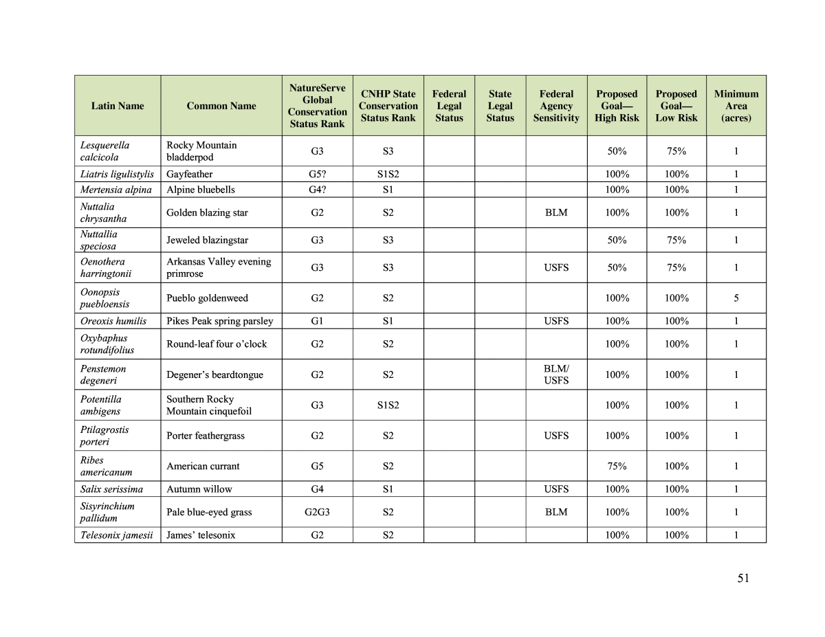
5 4. Develop and Assign Weightsâweight the conservation elements in the NatureServe Vista database with input from stakeholders. 5. Summarize Conservation Valuesâgenerate updated maps and associated reports based on weighting done in Step 4. 6. Import Land Use Scenariosâimport land use and management scenarios provided by PPCAG into NatureServe Vista. 7. Evaluate Alternative Land Use and Conservation Scenariosârun scenarios using all data inputs described. 8. Document Analysis with Reports and Metadata. Figure A. Diagram of Vista analysis process (Means 2007). Identify Conservation Element, Retention Goals, and Minimum Area Requirements On February 8, 2011, CNHP, NatureServe, and PPACG met with resource experts from the Colorado Division of Wildlife (CDOW), U.S. Fish and Wildlife Service, and U.S. Army Corp of Engineers to identify conservation elements and NatureServe Vista inputs. Conservation elements or elements are those species, plant communities, and ecological systems that the PPACG strives to conserve in land use planning. Inputs needed to conduct the NatureServe Vista analysis included minimum area requirements, retention goals, and land use compatibility for each element. The minimum area requirement is the smallest geographic area needed for each occurrence of the element to persist. Retention goals are used to articulate how much (or many) of each element must be conserved within the planning region for the element to persist. Retention goals may be expressed as the number of element or element occurrences, or as percent of occupied area by the element or element. Land use compatibility inputs define whether a particular land use is compatible, incompatible, or neutral in its effect on each element.
6 To determine the conservation element list, the project team studied the CNHPâs Element Occurrence1 data for sensitive species and natural communities documented within the study area. This list was refined in the February expert workshop. Species that were not likely to be affected by land use plans (such as species that occur in protected or other areas where development cannot occur, such as alpine plant communities) were removed; some species not tracked by CNHP but considered important by experts were added. See Appendix A for a list of the element species selected and their associated conservation status, retention goals, and minimum area requirements. See Appendix B for a list of plant community elements and their associated conservation status. Minimum area requirements were based on different criteria for different species groups. For example, territory size was used for songbirds, CDOWâs buffer distances for raptor nests, and metapopulation needs for butterflies. When possible, CNHPâs element occurrence specifications (CNHP 2011) were used to define minimum area (primarily for rare plants) (Appendix A). For species, retention goals were based on percent of occurrences and categorized using CNHPâs global and state conservation status ranks (Table A). When necessary, goals were modified to account for the number of occurrences (e.g., for a species with three occurrences, a 33% goal is more appropriate than a 50% goal). For ecological systems and natural communities, as well as select large species occurrences, goals were based on percent of area (Table A). Table A. Retention Goal Categories Retention Goal Rules for Species and Plant Communities of Concern G1âG2: 100% regardless of high or low risk G3+ and S1: 100% regardless of high or low risk G3+ and S2: 75% = high risk, 100% = low risk G3+ and S3: 50% = high risk, 75% = low risk G4+ and S4: 33% = high risk, 66% = low risk G5/S5: 25% = high risk, 50% = low risk These initial goals were then modified to result in the whole number of occurrences (i.e., elements with less than two occurrences will always have a goal of 100%; two occurrences will either be 50% or 100%; three occurrences will be 33%, 66%, or 100%). Conservation Value Summary Once the land use and conservation element data were uploaded and prepared, the CNHP team could run the first NatureServe Vista analyses to create the conservation value summary (CVS) for the project area. The CVS is an overlay map of all conservation elements. The CVS map was weighted to place increased emphasis on NatureServeâs global status ranks and federal legal status (Figure B). 1A mapped occurrence of a species or ecological community (element) using standard mapping methods developed by NatureServe and the network of natural heritage member programs. http://www.natureserve.org/prodServices/heritagemethodology.jsp.
7 Figure B. Conservation Value Summary A, Weighted by NatureServe Global Status Ranks and Federal Legal Status. Land Use Category Crosswalk To begin the evaluation of land use scenarios in NatureServe Vista, a crosswalk between land use raster categories supplied by Placeways and the categories used in the expert review meeting
8 was needed to develop standardized NatureServe Vista input values (Table B). When necessary, aerial imagery was used to help determine the most appropriate crosswalk category. The land use scenarios provided covered only Teller and El Paso Counties, so the 2006 National Land Cover Database for Pueblo County was used. Table B. Land Use Category Crosswalk for NatureServe Vista Analysis Placeways Land Use Crosswalked Land Use Category Used in NatureServe Vista Federal open Government: open federal lands (including military down-range areas) Vacant urban Residential: vacant urban Open space Parks, recreation, greenbelt: protected open space Under 5 Residential: 1 to 5 acres 35 plus Residential: 35 plus acres Public open Government: open federal lands (including military down-range areas) Military Government: large military installations (built-up areas) Vacant Rural Residential: vacant rural 35 plus acres Farm Agriculture: tilled agriculture Residential Residential: urban residential less than 1 acre Road General urbanization: roads (second iteration crosswalked to protected open space to avoid raster resolution issues that were causing false-negative responses) Public Parks, recreation, greenbelt: developed recreation facilities Mining General urbanization: industrial 5 to 35 Residential: 5 to 35 acres Commercial General urbanization: commercial Irrigated Agriculture: tilled agriculture Scenario Evaluation Next the CNHP team used NatureServe Vista to evaluate five potential development scenarios using the land use data described against a baseline (âCurrent Conditionâ) scenario. All potential development scenarios and the Current Condition scenario were provided by Placeways, in collaboration with PPACG. Files were supplied as 30-meter resolution rasters coded by land use type. The five initial potential development scenarios tested were Infill, Trend, Build-out, Conservation A, and Conservation B. The Infill scenario emphasized directing new development to vacant lands within urbanized areas. The Trend scenario assumed a âbusiness as usualâ approach to future development. The Build-out scenario assumed that the maximum practical amount of development would occur. The Conservation A scenario used the CVS to direct development away from the highest priority conservation elements. The B scenario restricted all development within CVS polygons, with emphasis placed on protected remnant tallgrass prairies (the most threatened plant communities in the study area). Using the results of the NatureServe Vista analysis on these five scenarios, PPACG developed a final, preferred development scenario: the SAF scenario. Refer to Placeways (2011) for the full discussion of
9 development scenarios. Appendix C is a summary of the compatibility of land use by species and plant community elements. During the process of running the NatureServe Vista analysis on the initial five potential development scenarios, it appeared that the coding of some inputs was leading to erroneous results. Therefore, refinements were made, as follows: 1. Land use in all counties surrounding El Paso and Teller was coded to open space so that portions of element occurrences that fall outside of the two counties would not show conflicts and cause false-negative results. 2. The Colorado Ownership, Management, and Protection (COMAP) data set was used to override the land use rasters provided by Placeways as a more accurate representation of conserved lands. 3. Most of the U.S. Air Force Academy was recoded to open public lands (the supplied raster showed the entire area as âbuilt up industrialized military base areas,â which was resulting in false conflicts with issues surrounding Prebleâs meadow jumping mouse). 4. Select species occurrences that were mapped at a large scale were removed from the NatureServe Vista project (e.g., a 25,000 acre massasauga rattlesnake occurrence that encompassed all suitable habitat). 5. Area-based goals set at 100% were dropped to 90% to account for mapping error. In addition, species occurrences that covered a large area (>1,000 acres) were changed from number of occurrences to percent of area to make the results more realistic (e.g., mountain plover, swift fox). In addition, subsequent to the initial NatureServe Vista analyses, the PPACG realized that an incorrect version of the Infill scenario had been provided to CNHP. Therefore, the corrected Infill scenario was rerun in the revised NatureServe Vista model, along with the current condition scenario. The first and only run of the SAF was also conducted using the revised NatureServe Vista model. Note that, given the differences in NatureServe Vista inputs, the SAF results and the revised Infill and Current Condition results are not directly comparable with results from the initial potential development scenario analyses. NatureServe Vista Results Figures C through K show areas of conflict between proposed land use and conservation values for each development scenario provided by PPACG. All project partners agreed that the conservation B scenario resulted in excessive sprawl across eastern El Paso County, so it was not considered in subsequent PPACG planning exercises. As previously noted, the remaining scenarios were incorporated into PPACG planning workshops and finally adapted by PPACG into the preferred development scenario: the small area forecast (SAF) scenario. The maps show conflicts geographically: Appendix D and E show the level of conflict in percent of goal met for each conservation element. Appendix D shows the percentage of conservation goals met under the current conditions scenario and under the SAF scenario. Appendix E shows the percentage of conservation goals met by the other five potential development scenarios (current condition, infill, buildout, trend, conservation A and conservation B).
10 In general, the NatureServe Vista results achieved in this project are atypical. Several elements did not meet retention goals in either the Current Condition or any development scenario. In addion, for several elements, the percentage of goal met was higher in the development scenarios than in the Current Condition scenario. Review of initial results indicated that some of these issues were related to mapping errors in the scenarios. For example, some areas coded as developed categories in the Current Condition scenario âimprovedâ to undeveloped categories in the future development scenarios, which seems unrealistic. It appears that part of the explanation for these confusing results could be associated with the Vacant Urban land use category. Almost all the elements were coded as incompatible with this land use. It may be that development scenarios that change existing Vacant Urban lands to parks, open space, or other undeveloped categories could be a contributing factor. In addition, comparison of the Current Condition scenario with aerial photographs revealed that mapping codes did not match on-the-ground conditions in some areas. The NatureServe Vista inputs were adjusted to address as many of these issues as possible per the previous discussion. These caveats aside, the SAF is performing quite well for the conservation elements. For the six federally listed and Candidate species, the percentage of goals met is essentially the same in the SAF compared with the Current Condition. The only federally listed species that is not meeting its retention goal in the SAF is the Mexican spotted owl, which does not meet the retention goal in Current Condition either. This result is likely attributable to current impacts on this bird and mapping imprecision. The SAF met retention goals for the majority of state-listed and Special Concern species. Only two (swift fox and Townsendâs big-eared bat) fell short. The swift fox is a wide-ranging prairie species that is almost certain to be affected by any significant development on the plains. The big-eared bat result probably reflects data precision issues. This species inhabits small-scale locales such as mines and caves. Specifically, mines mapped as large areas have a disproportionate impact on GIS results compared with the small subset of area that would actually be occupied by the bat. In addition, Cave of the Winds is coded as a commercial land use, which was considered an incompatible category in the analyses for almost all species. Overall, riparian and wetland systems were not significantly affected by the SAF. The wetland ecological system did not meet its goal in the SAF, but according to the Current Condition scenario, existing land use (especially the gold mine in Teller County) is already adversely affecting wetlands. For CNHP potential conservation areas (PCAs), the SAF performed comparably with the Current Condition with only two exceptions: Fountain Creek and Marksheffel Road. The Fountain Creek PCA was delineated for bald eagles, and Marksheffel Road for black-tailed prairie dogs. These PCAs are of comparatively lower biodiversity significance because of the existing urban encroachment.
11 Figure C. Conflict and compatibility in the Current Condition (baseline) scenario (first run).
12 Figure D. Conflict and compatibility in the Infill development scenario (first run).
13 Figure E. Conflict and compatibility in the Trend scenario (only run).
14 Figure F. Conflict and compatibility in the Build-out scenario (only run).
15 Figure G. Conflict and compatibility in the Conservation A scenario (only run).
16 Figure H. Conflict and compatibility in the Conservation B scenario (only run).
17 Figure I. Conflict and compatibility in the Current Condition scenario (second run).
18 Figure J. Conflict and compatibility in the Infill scenario (second run).
19 Figure K. Conflict and compatibility in the Small Area Forecast scenario (only run).
20 N-SPECT ANALYSIS The Nonpoint Source Pollution and Erosion Comparison Tool (N-SPECT) was developed by the National Oceanic and Atmospheric Administration (NOAA) Coastal Services Center for use as a spatially explicit screening tool that models basic hydrologic processes, including overland flow, erosion, and nonpoint source pollution within a watershed (Eslinger et al. 2005). Results of N-SPECT analyses can be used to help understand and predict the impacts of various land use and management decisions on water quality. Methods Five potential development scenarios were compared with a baseline of assumed current conditions. Scenarios tested were Trend, Build-out, Infill, Conservation A, and Conservation B. All scenarios and the baseline were provided by Placeways in collaboration with PPACG. Files were supplied as 30-meter resolution rasters coded by land use type. However, N-SPECT requires land cover (rather than land use or land type) to model pollutant loads. Therefore, the original land use categories supplied by Placeways were crosswalked to, and combined with, the 2006 National Land Cover Database (NLCD) land cover values (Table C). For existing and planned urban development (i.e., development more dense than 35 Plus), Placeways categories were given priority over NLCD. For existing and planned nonurban development, the NLCD categories were used. For example, the â35Plusâ land use category was assumed to be dispersed enough in its development that the underlying land cover from NLCD was used instead. In some cases, aerial imagery was used to help determine the most appropriate crosswalk category. Areas of âno dataâ within the development scenarios were assumed to be roads and coded as such. The potential development scenarios covered only Teller and El Paso Counties, so NLCD was used for Pueblo County. See Appendix F for maps showing final land cover inputs for each scenario. N-SPECT creates a hydrology model from supplied elevation data. The hydrology modeled is restricted to the study area, which includes all of Teller and El Paso Counties and Pueblo County north of the Arkansas River. Only the hydrology of Fountain Creek and Chico Creek watersheds are complete within this study area. The portion of the Arkansas River included in this N-SPECT analysis takes into account only the inputs from these two watersheds; the full headwaters of the Arkansas River were not modeled. Other model inputs were pollutant coefficients, pollutant-land cover response curves, precipitation regime, number of raining days, elevation, soil K-factor, R-factor, and hydrologic group. The N-SPECT default pollutants of lead, nitrogen, phosphorus, and zinc, as well as total suspended solids, accumulated sediment, and accumulated runoff were modeled. Because pollutant coefficients and response curves specific to the study area are not available, N-SPECT defaults were used. See the N-SPECT Results section for additional discussion. Using defaults lowers confidence in the results, which cannot be validated without on-the-ground sampling.
21 Table C. Crosswalk of Land Cover Data for N-SPECT Analysis Placeways Land Use NLCD Land Cover Final Land Cover Used in N- SPECT Commercial Developed, high intensity High intensity developed Residential Under 5 Developed, medium intensity Medium intensity developed Road Developed, low intensity Low intensity developed 5 to 35 Developed, open space Irrigated Cultivated crops Cultivated land Pasture/Hay Pasture/Hay Grassland/Herbaceous Grassland Deciduous forest Deciduous forest Evergreen forest Evergreen forest Mixed forest Mixed forest Shrub/Scrub Scrub/Shrub Palustrine forested wetland Palustrine forested wetland Woody wetlands Palustrine scrub/shrub wetland Palustrine scrub/shrub wetland Palustrine emergent wetland (persistent) Palustrine emergent wetland Emergent herbaceous wetlands Mining Barren land (rock/sand/clay) Bare land Open water Water Palustrine aquatic bed Palustrine aquatic bed Precipitation data used in the analysis were based on total annual precipitation averaged over the years 1980 to 1997, from Daymet (http://www.daymet.org). N-SPECT documentation suggests using PRISM precipitation data from the Oregon Climate Service at Oregon State University (http://www.ocs.orst.edu/prism/). However, the higher-resolution Daymet data (1 km instead of 4 km for PRISM) was used for this study because of the relatively small size of the study area. Number of Raining Days is defined within the N-SPECT documentation as the average number of days in a year that have rain events that produce overland flow. In the absence of clear-cut guidance on deriving this value, the annual average (over the past 3 years) number of days with greater than or equal to 0.5 inches of rain for the Colorado Springs area, which is 5, was chosen. This was derived from the National Weather Service annual summary data available online (http://www.weather.gov/). Personal communication with Dr. David Eslinger, lead N- SPECT developer, confirmed that this was an appropriate way to derive the Raining Days parameter (personal communication with Michelle Fink, CNHP, June 2011). Elevation data used in the analyses are from the U.S. Geological Survey 30 meter Digital Elevation Model. All raster inputs were snapped to this data set for the analyses.
22 Soil K-factor and hydrologic group data used in the analysis came from the Natural Resources Conservation Service (NRCS) Soil Survey Geographic (SSURGO) database for Teller, El Paso, and Pueblo Counties (http://soildatamart.nrcs.usda.gov). Guidance supplied on the N-SPECT website was followed for preprocessing the SSURGO data. In addition, the soil data was edited to fill in data gaps where surveyor access was not permitted by using surrounding soil types and overlaying vegetation cover data to interpolate missing information. R-factor, or run-off erosivity factor, is defined within N-SPECT documentation as quantifying the effects of raindrop impacts on soil and therefore reflects the amount and rate of runoff associated with rainfall amounts and soil types. This information is not available within SSURGO and, for Colorado, is in fact available only as a hardcopy map of hand-drawn isolines created by the NRCS in 1997 (isoerodent R map for Colorado). A scanned image file of this map was obtained from the state NRCS office. The image was then cropped, rotated, and georeferenced to spatially overlay it onto the other project area data. The isoerodent lines and values were screen-digitized as a contour map, which was then interpolated using tension splining to create a continuous raster surface that could be used as an input in N-SPECT. Analysis outputs for each pollutant and other factors modeled for each development scenario were then compared with modeled baseline conditions by calculating the percent change from baseline. N-SPECT models overland flow in addition to stream channel accumulation, so raw outputs are continuous surfaces over the entire study area. Because water quality is measured and regulated within stream channels, the percent change calculations were restricted to stream channels only, with the assumption that this would be easier to understand and display as polylines representing stream channels colored to represent relative departure from baseline. N-SPECT Results N-SPECT examines the relationships among land cover, soil characteristics, topography, and precipitation data to model spatially explicit pollutant loads and downstream accumulations and concentrations. These data sets represent local conditions. However, pollutant coefficients and response curves rely on the default values supplied with N-SPECT. These values were developed originally for use in models of western Oahu, Hawaii. N-SPECT lead developer Dr. David Eslinger considers the values robust enough for general application, but stresses that, in the absence of locally developed and verified pollutant response curves, the most appropriate use of the models is in the form of percent change from baseline, as opposed to reporting specific modeled concentration values (personal communication with Michelle Fink, CNHP, June 2011). Percent change from baseline for each modeled factor was summarized over the Fountain Creek and Chico Creek watersheds for each development scenario (Tables D and E and Figures L and M). For the Fountain Creek watershed, the Build-out and Conservation B scenarios had the greatest impact on modeled water quality. The Conservation A scenario had the least overall impact, and the Infill scenario had the second least impact. The Trend and Small Area Forecast (SAF) scenarios came out similar to one another, with a moderate level of relative impact.
23 Table D. Average Percent Change from Current Condition for Fountain Creek Watershed Fountain Creek Watershed Average Percent Change from Current Condition Parameter Infill Trend Build- out Conservation A Conservation B SAF (Preferred) Accumulated runoff 11% 13% 21% 11% 16% 16% Total suspended solids 3% 4% 7% 2% 1% 5% Nitrogen concentrations 4% 5% 7% 3% 6% 5% Phosphorus concentrations 20% 27% 38% 13% 34% 25% Lead concentrations 12% 14% 21% 9% 23% 14% Zinc concentrations 5% 8% 10% 5% 7% 7% Accumulated sediment -3% -4% -7% -2% -2% -4% Table E. Average Percent Change from Current Condition for Chico Creek Watershed Chico Creek Watershed Average Percent Change from Current Condition Parameter Infill Trend Build- out Conservation A Conservation B SAF (Preferred) Accumulated runoff 3% 2% 29% 16% 61% 7% Total suspended solids -2% -2% 1% 1% -24% -4% Nitrogen concentrations 1% 1% 7% 5% 16% 2% Phosphorus concentrations 2% 2% 30% 19% 57% 5% Lead concentrations 1% 1% 18% 10% 17% 1% Zinc concentrations 0.5% 1% 12% 7% 12% 0.3% Accumulated sediment -1% -1% -7% -1% -14% -1% For the Chico Creek watershed, the Conservation B scenario had by far the most impact on water quality, with Build-out having the next greatest impact. The Trend and Infill scenarios have the least impact and are in fact very close to current conditions. The SAF scenario had the next lowest impact, then the Conservation A scenario. Overall, the Conservation B scenario encourages excessive exurban sprawl in eastern El Paso County, with significant consequences to water quality. From a water quality standpoint across both watersheds, the Conservation B and Build-out scenarios are the least recommended.
24 Figure L. Average percent change from current condition for Fountain Creek Watershed -25% -15% -5% 5% 15% 25% 35% 45% 55% 65% Pe rc en t c ha ng e Percent Change from Current Fountain Creek Accumulated Run-off Total Suspended Solids Nitrogen Concentrations Phosphorus Concentrations Lead Concentrations Zinc Concentrations Accumulated Sediment
25 Figure M. Average percent change from current condition for Chico Creek Of the water quality factors modeled, PPACG is primarily interested in nitrogen, phosphorus, runoff, and total suspended solids (personal communication Rich Muzzy, PPACG). Therefore, although all default factors were modeled, only these four were subsequently converted to polylines representing percent change from baseline (Figures N through Q). -25% -15% -5% 5% 15% 25% 35% 45% 55% 65% Pe rc en t c ha ng e Percent Change from Current Chico Creek Accumulated Run-off Total Suspended Solids Nitrogen Concentrations Phosphorus Concentrations Lead Concentrations Zinc Concentrations Accumulated Sediment
26 Figure N. N-SPECT analysis comparing SAF scenario to baseline for nitrogen.
27 Figure O. N-SPECT analysis comparing SAF scenario to baseline for phosphorus.
28 Figure P. N-SPECT analysis comparing SAF scenario to baseline for runoff.
29 Figure Q. N-SPECT analysis comparing SAF scenario to baseline for total suspended solids.
30 MARXAN ANALYSIS Marxan is a decision support software program for conservation planning and reserve system design (Ball et al. 2009). Marxan helps planners identify geographic areas to protect and manage for species and ecological systems. It does this by maximizing cost-benefit ratios to identify an optimal reserve design to achieve specific conservation goals. Goals are expressed as number of element occurrences, percent of area, or both. How âcostâ is defined depends on the project objectives and available data. Cost can be actual financial value of land or a more abstract indicator, such as current or proposed levels of human development (i.e., that would serve as a proxy for the desirability and practicality of implementing a conservation project in a particular area). Methods The study area must first be divided into âplanning units.â Marxan then selects a subset of planning units that optimizes stated conservation goals against given costs. The planning units chosen for this project represent Public Land Survey System (PLSS) sections, each of which is approximately 640 acres in size. There are 3,420 planning units in the study area. These units were chosen because they 1) coincide reasonably well with property boundaries, making them suitable for land use planning purposes; 2) are all of similar size, which is necessary to reduce selection bias within Marxanâs algorithms (PLSS sections can vary considerably in size and shape in mountainous areas, but were reasonably uniform over the study area); and 3) provide a resolution that was a good compromise between conservation element input sizes and computational requirements. To keep planning unit sizes relatively uniform, they were not clipped at the edge of the study area boundary but allowed to overlap as necessary. Conservation elements used in the Marxan analysis were the same as those used in the NatureServe Vista analysis. Goal inputs were based on initial NatureServe Vista goals (Table E and Appendix G), but minor differences in study area size and input preprocessing requirements for the two programs resulted in some differences in the final goals used (Appendix H). Both âHigh Riskâ and âLow Riskâ goal sets were run. âHigh Riskâ means that the goal is set such that the risk of not adequately conserving the species or habitats of concern is high, and âLow Riskâ indicates that the goal is set so that the risk of not adequately conserving the species or habitat is assumed to be low. Note that these risk levels are based on best professional judgment of local and regional experts and have not been empirically tested or otherwise validated. G and S ranks refer to Natural Heritage Methodology global and state imperilment ranks, respectively. B ranks are Natural Heritage Methodology potential conservation area biodiversity ranks. Each planning unit must be assigned a âcost,â the additive total of which Marxan attempts to minimize in the final solution. Because actual land values and other literal dollar amounts, such as restoration or management costs, are very difficult to estimate and apply over large project areas, some indicator of ecological integrity frequently is used as a cost surrogate in Marxan (Ardron et al., 2010). For this analysis, a statewide landscape integrity layer developed in 2008 (CNHP and The Nature Conservancy 2008) was used and the mean impact score calculated for each planning unit as a starting cost value. The higher the value, the greater the anthropogenic impact to the area, which acts as a surrogate for the practicality and desirability of protecting or managing an area for conservation values. The SAF development scenario was then
31 overlaid onto the planning units and the costs of some units adjusted upward to indicate areas of planned low- to medium-intensity development. Areas of current or planned high-intensity development were âlocked outâ entirely, preventing Marxan from including them in a solution. Because PPACG would prefer to deal primarily with areas within Teller and El Paso Counties, a second cost value was developed that, in addition to the process described, increased the cost of all planning units within Pueblo County to be higher than the highest cost within the other two counties, as a way to influence Marxan to select only units within Pueblo County if no other way to meet an element goal was possible. Table E. Goal Scheme Rules Initial Goal Scheme Rules for Elements and PCAs (high risk | low risk): G1âG2 at 100% | 100% G3+ S1 at 100% | 100% (90% if acreage) G3+ S2 at 75% | 100% (90% if acreage) G3+ S3 at 50% | 75% G3 S4 at 33% | 66% G4+ S4 at 10% | 50% G3 S5 at 10 | 50% G4+ S5 at 5% | 33% B1 and B2 PCAs at 75% | 90% B3âB5 PCAs at 33% | 50% These initial goals were then modified to result in whole numbers of occurrences (i.e., elements with fewer than two occurrences will always have a goal of 100%; two occurrences will be either 50% or 100%; three occurrences will be 33%, 66%, or 100%). Sensitivity and selection bias testing was then performed on various input parameters, such as the Boundary Length Modifier, Species Penalty Factor, and edge unit boundary lengths, as advocated in the Marxan Good Practices Handbook (Ardron et al., 2010), to produce as robust and defensible a solution as possible. For more information about these parameters and the testing procedures, see the Marxan User Manual (Game and Grantham 2008) and the Marxan Good Practices Handbook. After testing, the Boundary Length Modifier, which influences the compactness of the final solution, was set at 0.1 for all runs. The Species Penalty Factor, which weights how important each conservation element is to the overall objectives of the analysis, was based on Natural Heritage Program global imperilment ranks (www.cnhp.colostate.edu). To prevent planning units on the edge of the study area from having a different probability of being selected from interior units, edge unit boundary values were reduced until a bias was no longer detected (reduced to 18.75% of original length value of 1,600, or 300). These inputs result in four analyses: 1) low-risk conservation goals, counties unweighted; 2) high-risk conservation goals, counties unweighted; 3) low-risk conservation goals, Pueblo County weighted for avoidance; and 4) high-risk conservation goals, Pueblo County weighted for avoidance. Each of these analysis runs had 1,000 repetitions of one million steps each. A fifth analysis was also conducted that specifically incorporated areas identified by PPACGâs 2011 Green Infrastructure Workshop. Workshop participants delineated areas considered important to conserve during regional planning efforts. The planning units were clipped to the shape of proposed high-intensity development areas as indicated in the SAF scenario and locked out, and
32 the âGreen Infrastructure Nodesâ (GI nodes) provided by PPACG (Figure R) were examined to see how much of each conservation element they contained. The objective of this analysis was to determine which conservation element goals could not be met with the GI nodes and identify where else conservation efforts should be focused to make up for the shortfall. Note that some of the GI nodes as drawn overlap with existing or planned high-intensity development. These areas of development were clipped out of the nodes before analysis. Because the extreme constraints placed on this analysis may result in a âlocal minimaâ false solution (Ardron et al., 2010), this analysis was run with 10,000 repetitions at one million steps each to give Marxan plenty of opportunity to find the best solution. Marxan Results When using conservation planning decision support software such as Marxan, there is no one right answer. The resulting solutions depend on the goals and objectives of the analysis. There are five Marxan analysis solutions presented here, all of which take into account land use and land cover changes proposed in the SAF scenario. Four of the presented solutions show a comprehensive biodiversity conservation network of suggested areas to protect or manage for natural values. They look at both high- and low-risk conservation goals and are either weighted or unweighted to avoid selecting areas within Pueblo County (Figures S through X). The fifth analysis (using Green Infrastructure data) focuses on only those species and habitats that would be directly affected by proposed new areas of development. This analysis looked only at those species and habitats that were directly affected by new development, as proposed in the SAF scenario, and is therefore not a complete network of conservation areas. The analysis assumes that the entire network of proposed GI nodes will be conserved. The âmitigationâ areas shown in Figure S are the areas required in addition to the GI nodes to make up for impacts to directly affected elements. In addition, note that by clipping planning units to the shape of proposed areas of development, their relative size to the other planning units changed, which may have reintroduced a unit selection bias that the initial sensitivity tests were run to avoid (Ardron et al., 2010). When viewing these five solutions, note that the entire area of each planning unit within a Marxan analysis solution does not necessarily need to be conserved if the conservation element does not cover the entire area. However, no solution met all conservation element goals, although more than 95% of all goals were met in each case. Note that if a solution contained at least 95% of a element goal, that element was considered to be fully met. Some goal shortfalls may be the result of data accuracy issues, such as for American currant (Ribes americanum) and grassy slope sedge (Carex oreocharis). In some cases, conservation elements may be affected by currently existing development (i.e., may no longer be there), such as for Prebleâs meadow jumping mouse (Zapus hudsonius preblei) and Barnebyâs feverfew (Bolophyta tetraneuris). Both of these issues should be investigated further. The planned development within the SAF scenario appears to negatively affect several species. The Colorado blue butterfly (Euphilotes rita coloradensis) is a T2S2 regional endemic subspecies (occurs in four western states) that is dependent on isolated and increasingly rare microhabitats. The Gunnisonâs prairie dog (Cynomys gunnisoni) montane population is also ranked as T2S2 and is recognized by the U.S. Fish and Wildlife Service as a Candidate species (76 FR 66370 66439). The American yellow ladyâs slipper (Cypripedium calceolus parviflorum, also known as Cypripedium parviflorum) is a G5S2
33 orchid that is considered a species of concern by the U.S. Forest Service because it is sensitive to being overharvested by orchid collectors and sellers. Please note, these results are intended for initial planning and prioritization only and are based on available data. With regard to the data available on the locations of species of concern, the absence of evidence is not evidence of absence. On-the-ground clearance surveys should be conducted to confirm the presence of the species and habitats of concern within the areas chosen.
34 Figure R. Green Infrastructure areas identified at PPACGâs 2011 workshop.
35 Table F. Marxan Results for the Mitigation Solution Using Green Infrastructure Nodes Conservation Element Goal Met % of Goal Met ECOLOGICAL SYSTEMS Wetland (coarse filter) Yes 117% BIRDS Northern goshawk Yes 501% MAMMALS Townsendâs big-eared bat subspecies Yes 1,307% Gunnisonâs prairie dog Yes 100% INSECTS Simius roadside skipper Yes 1,888% Colorado blue Yes 127% VASCULAR PLANTS Amorpha nana Yes 2,107% Aquilegia saximontana Yes 312% Carex oreocharis Yes 412% Lesquerella calcicola Yes 1,284% Ribes americanum Yes 121% Unamia alba Yes 604% Viola pedatifida Yes 232% PLANT COMMUNITIES Festuca arizonicaâMuhlenbergia filiculmis herbaceous vegetation Yes 183% Festuca arizonicaâMuhlenbergia montana herbaceous vegetation Yes 432% Hesperostipa neomexicana herbaceous vegetation Yes 205% Populus tremuloides/Alnus incana forest Yes 299% Pseudotsuga menziesii/Betula occidentalis woodland No* 13% Pseudotsuga menziesii/Cornus sericea woodland Yes 231% * Most occurrences of this plant community are already in existing protected lands. Additional unprotected lands could therefore not be selected to mitigate for impacts from planned development. NOTE: This analysis looked only at those species and habitats that were directly affected by new development, as proposed in the SAF scenario; therefore, this is not the complete list of conservation elements used in the other analyses.
36 Figure S. Marxan best solution looking at conservation impacts of proposed development only.
37 Figure T. Marxan best solution for low-risk conservation goals (counties unweighted).
38 Figure U. Marxan best solution for high-risk conservation goals (counties unweighted).
39 Figure V. Marxan best solution for low-risk conservation goals (Pueblo County minimized).
40 Figure W. Marxan best solution for high-risk conservation goals (Pueblo County minimized).
41 Conclusions General Statements and Recommendations The primary product of these analyses was a standardized, scientifically based, well- documented process for evaluating the potential impacts of several development scenarios on the conservation elements and their associated goals in the Pikes Peak Area. In addition, it supported input from the PPACG stakeholders throughout the planning and analysis process, and the selection of a preferred scenarioâthe SAFâthat, based on the analyses, showed the least amount of overall impacts to conservation elements. It is important to note that much of the study area is urbanized and most of the future proposed development is close to already affected areas. But the analyses did show potential impacts and mitigation opportunities and that the biggest concern is increased encroachment over time into the native prairie of the area. The most significant lesson learned from the N-SPECT analysis is that the results of this type of analysis would benefit significantly from the development of local scale inputs by hydrology experts. Without this local scale input, the results could be presented only as percent of change rather than actual modeled values. Thus, it is recommended that if PPACG would like to further employ N-SPECT for planning purposes, the model should be refined with local coefficients (that are currently not available), which in turn would be validated by a hydrologist or other water quality planning professional. In addition, in future analysis using the Marxan tool, the level of constraint imposed in some of the mitigation analysis should be considered because it may have minimized the usefulness of the Marxan tool. Finally, the results of these analyses are intended for initial planning and prioritization only and are based on best available data. With regard to the data that were available on the locations of species of concern, absence of evidence is not evidence of absence. On-the-ground clearance surveys should be conducted to confirm the presence of the species and habitats of concern within the areas chosen. NatureServe Vista Conclusions The NaturServe Vista analyses results contributed to the development of PPACGâs preferred development scenario: the SAF. NatureServe Vista supported detailed documentation of this decision-making process, including the conservation elements chosen, and the criteria used to conduct the analyses, such as the minimum area requirements, retention goals, and land use compatibility for each conservation element (species, plant community, and ecological system). NatureServe Vista also supported the ability for stakeholders to weight conservation elements and goals such as species with a federal legal status to see how different weighting would effect the potential development outcomes. In addition, NatureServe Vista made it possible to alter inputs (data, goals, and priorities) at several points in the analytical and planning process to account for changes in data and input from stakeholders. These kinds of changes, which occur midstream many times over during the course of transportation planning or project development, are typical, so having a system that can adapt as changes occur supports a more efficient response and more accurate results.
42 The CNHP team used NatureServe Vista to evaluate five potential development scenarios. The five initial potential development scenarios tested were Infill, Trend, Build-out, Conservation A, and Conservation B. The Infill scenario emphasized directing new development to vacant lands within urbanized areas. The Trend scenario assumed a âbusiness as usualâ approach to future development. The Build-out scenario assumed that the maximum practical amount of development would occur. The Conservation A scenario used the CVS to direct development away from the highest priority conservation elements. The Conservation B scenario restricted all development within CVS polygons, with emphasis placed on protected remnant tallgrass prairies (the most threatened plant communities in the study area). Using the results of the NatureServe Vista analysis on these five scenarios, PPACG developed a final, preferred development scenario: the Small Area Forecast (SAF) scenario. With NatureServe Vista, the CNHP team was able to generate a summary of the compatibility of land use by species and plant community elements (Appendix C). All project partners agreed that the Conservation B scenario resulted in excessive sprawl across eastern El Paso County and was therefore not considered in subsequent PPACG planning exercises. As previously noted, the remaining scenarios were incorporated into PPACG planning workshops and finally adapted by PPACG into the preferred development scenario: the SAF scenario. The SAF is performing quite well for the conservation elements. For the six federally listed and Candidate species, the percentage of goals met is essentially the same in the SAF compared with the Current Condition scenario. The only federally listed species that is not meeting goal in the SAF is the Mexican spotted owl, which does not meet the retention goal in the Current Condition scenario either. This result is likely attributable to current impacts on this bird and mapping precision. The SAF met retention goals for the majority of state-listed and Special Concern species. Only two (swift fox and Townsendâs big-eared bat) fell short. The swift fox is a wide-ranging prairie species that is almost certain to be affected by any significant development on the plains. The big-eared bat result probably reflects data precision issues. This species inhabits small scale locales such as mines and caves. Specifically, mines mapped as large areas have a disproportionate impact on GIS results compared with the small subset of area that would actually be occupied by the bat. In addition, Cave of the Winds is coded as a commercial land use, which was considered an incompatible category in NatureServe Vista for almost all species. For CNHP potential conservation areas (PCAs), the SAF performed comparably with the Current Condition scenario, with only two exceptions: Fountain Creek and Marksheffel Road. The Fountain Creek PCA was delineated for bald eagles and Marksheffel Road for black-tailed prairie dogs. These PCAs are of comparatively lower biodiversity significance because of the existing urban encroachment.
43 N-SPECT Conclusions The percent of change from baseline for each modeled factor was summarized over the Fountain Creek and Chico Creek watersheds for each development scenario (Tables D and E, Figures L and M). For the Fountain Creek watershed, the Build-out and Conservation B scenarios had the greatest impact on modeled water quality. The Conservation A scenario had the least overall impact, and the Infill scenario had the second least impact. The Trend and sSmall Area Forecast (SAF) scenarios came out very similar to one another, with a moderate level of relative impact. For the Chico Creek watershed, the Conservation B scenario had by far the most impact on water quality, with Build-out having the next greatest impact. The Trend and Infill scenarios had the least impact and are in fact very close to current conditions. The SAF scenario had the next lowest impact, then the Conservation A scenario. Overall, the Conservation B scenario encourages excessive urban sprawl in eastern El Paso County, with significant consequences to water quality. From a water quality standpoint across both watersheds, the Conservation B and Build-out scenarios are the least recommended. Marxan Conclusions When using conservation planning decision support software such as Marxan, there is no one right answer. The resulting solutions depend on the goals and objectives of the analysis. There are five Marxan analysis solutions presented here, all of which take into account land use and land cover changes proposed in the SAF scenario. Four of the presented solutions show a comprehensive biodiversity conservation network of suggested areas to protect or manage for natural values. They look at both high- and low-risk conservation goals and are either weighted or unweighted to avoid selecting areas within Pueblo County (Figures S through W). The fifth analysis (using Green Infrastructure data) focuses on only those species and habitats that would be directly affected by proposed new areas of development. This analysis looked at only those species and habitats that were directly affected by new development, as proposed in the SAF scenario and is therefore not a complete network of conservation areas. The analysis assumes that the entire network of proposed GI nodes will be conserved. The âmitigationâ areas shown in Figure S are the areas required in addition to the GI nodes to make up for impacts to directly affected elements. In addition, note that by clipping planning units to the shape of proposed areas of development, their relative size to the other planning units changed, which may have reintroduced a unit selection bias that the initial sensitivity tests were run to avoid (Ardron et al., 2010). When viewing these five solutions, note that the entire area of each planning unit within a Marxan analysis solution does not necessarily need to be conserved if the conservation element does not cover the entire area. However, no solution met all conservation element goals, although more than 95% of all goals were met in each case. Note that if a solution contained at least 95% of a element goal, that element was considered to be fully met. Some goal shortfalls may be the result of data accuracy issues, such as for American currant (Ribes americanum) and grassy slope sedge (Carex oreocharis). In some cases, conservation elements may be affected by existing development (i.e., may no longer be there), such as for Preble's meadow jumping mouse (Zapus hudsonius preblei) and Barnebyâs feverfew (Bolophyta tetraneuris). Both of these issues
44 should be investigated further. The planned development within the SAF scenario appears to negatively affect several species. The Colorado blue butterfly (Euphilotes rita coloradensis) is a T2S2 regional endemic subspecies (occurs in four western states) that is dependent on isolated and increasingly rare microhabitats. The Gunnisonâs prairie dog (Cynomys gunnisoni) montane population is also ranked as T2S2 and is recognized by the U.S. Fish and Wildlife Service as a Candidate species (76 FR 66370 66439). The American yellow ladyâs slipper (Cypripedium calceolus parviflorum, also known as Cypripedium parviflorum) is a G5S2 orchid that is considered a species of concern by the U.S. Forest Service because it is sensitive to being overharvested by orchid collectors and sellers.
45 REFERENCES CITED Ardron, J. A., H. P. Possingham, and C. J. Klein (eds). Marxan Good Practices Handbook, Version 2. Pacific Marine Analysis and Research Association, Victoria, British Columbia, Canada, 2010. www.pacmara.org. Ball, I. R., H.P. Possingham, and M. Watts. Marxan and Relatives: Software for Spatial Conservation Prioritisation. In Spatial Conservation Prioritisation: Quantitative Methods and Computational Tools (A. Moilanen, K. A. Wilson, and H. P. Possingham, eds.). Oxford University Press, Oxford, United Kingdom, 2009, pp. 185â195. Marxan version 2.4.3 Ã64 accessed August 2011 at www.uq.edu.au/marxan. Colorado Natural Heritage Program (CNHP) and The Nature Conservancy (TNC). 2008. Landscape Integrity in Colorado. GIS dataset. CNHP, Colorado State University, Fort Collins, Colo., and TNC, Colorado Field Office, Boulder, Colo. Game, E. T., and H. S. Grantham. Marxan User Manual: For Marxan Version 1.8.10. University of Queensland, St. Lucia, Queensland, Australia, and Pacific Marine Analysis and Research Association, Vancouver, British Columbia, Canada, 2008. Eslinger, D. L., H. J. Carter, E. Dempsey, M. VanderWilt, B. Wilson, and A. Meredith. The Nonpoint-Source Pollution and Erosion Comparison Tool. NOAA Coastal Services Center, Charleston, S.C., 2005. Accessed March 2011 at http://www.csc.noaa.gov/nspect/. Means, S. NatureServe Vista: An Analysis of a Tool for Green Infrastructure Planning: Madison County, Virginia. University of Virginia, School of Architecture, Department of Urban and Environmental Planning, PLAN512: Geographic Information Systems, Fall 2007. Available online at http://www.arch.virginia.edu/~dlp/Courses/P512F07/ShawnMeansVistaopt.pdf. Accessed November 2011. Placeways. CommunityViz Scenario Modeling. Draft Report Prepared for Pikes Peak Area Council of Governments. Colorado Springs, Colo., 2011.
46 APPENDIX A SPECIES ELEMENTS, RETENTION GOALS, AND MINIMUM AREA REQUIREMENTS USED IN THE NATURESERVE VISTA ANALYSIS Latin Name Common Name NatureServe Global Conservation Status Rank CNHP State Conservation Status Rank Federal Legal Status State Legal Status Federal Agency Sensitivity Proposed Goalâ High Risk Proposed Goalâ Low Risk Minimum Area (acres) AMPHIBIANS Rana pipiens Northern leopard frog G5 S3 SC BLM/ USFS 50% 75% 3 BIRDS Haliaeetus leucocephalus Bald eagle G5 S1B, S3N ST BLM/ USFS 100% 100% 500 Accipiter gentilis Northern goshawk G5 S3B BLM/ USFS 50% 75% 500 Buteo regalis Ferruginous hawk G4 S3B, S4N SC BLM/ USFS 50% 75% 500 Aquila chrysaetos Golden eagle G5 S3 50% 75% Falco peregrinus anatum American peregrine falcon G4T4 S2B SC BLM/ USFS 75% 100% 500 Lagopus leucurus White-tailed ptarmigan G5 S4 USFS 33% 66% 70 Grus canadensis tabida Greater sandhill crane G5T4 S2B, S4N SC 75% 100% Charadrius montanus Mountain plover G2 S2B SC BLM/ USFS 100% 100% 140 Numenius americanus Long-billed curlew G5 S2B SC BLM/ USFS 75% 100% 35
47 Latin Name Common Name NatureServe Global Conservation Status Rank CNHP State Conservation Status Rank Federal Legal Status State Legal Status Federal Agency Sensitivity Proposed Goalâ High Risk Proposed Goalâ Low Risk Minimum Area (acres) Athene cunicularia Burrowing owl G5 S4B ST BLM/ USFS 33% 66% 48 Strix occidentalis lucida Mexican spotted owl G3T3 S1B, SUN LT ST 100% 100% Melanerpes lewis Lewisâs woodpecker G4 S4 USFS 33% 66% 15 Dendroica graciae Graceâs warbler G5 S3B 50% 75% 5 Seiurus aurocapilla Ovenbird G5 S2B 75% 100% 4 Calcarius mccownii McCownâs longspur G4 S2B USFS 75% 100% 3 Leucosticte australis Brown-capped Rosy- Finch G4 S3B, S4N 50% 75% 1 FISH Etheostoma cragini Arkansas darter G3G4 S2 C ST BLM 75% 100% Oncorhynchus clarkii stomias Greenback cutthroat trout G4T2T3 S2 LT ST 100% 100% INSECTS Amblyscirtes simius Simius roadside skipper G4 S3 50% 75% 50? Callophrys mossii schryveri Mossâ elfin G4T3 S2S3 75% 100% 50 Celastrina humulus Hops ffeeding azure G2G3 S2 100% 100% 50 Euphilotes rita coloradensis Colorado blue butterfly G3G4T2T3 S2 100% 100% 50
48 Latin Name Common Name NatureServe Global Conservation Status Rank CNHP State Conservation Status Rank Federal Legal Status State Legal Status Federal Agency Sensitivity Proposed Goalâ High Risk Proposed Goalâ Low Risk Minimum Area (acres) Hesperia leonardus montana Pawnee montane skipper G4T1 S1 LT 100% 100% 50? MAMMALS (NON-GAME) Cynomys gunnisoni Gunnisonâs prairie dog G5 S5 C BLM/ USFS 25% 50% 2? Cynomys ludovicianus Black-tailed prairie dog G4 S3 SC BLM/ USFS 50% 75% 2 Myotis thysanodes Fringed myotis G4G5 S3 BLM/ USFS 50% 75% 2 Plecotus townsendii pallescens Townsendâs big-eared bat subspecies G4T4 S2 SC BLM/ USFS 75% 100% 2 Vulpes velox Swift fox G3 S3 SC BLM/ USFS 50% 75% 500 Zapus hudsonius preblei Meadow jumping mouse subspecies G5T2 S1 LT ST USFS 100% 100% 4 MAMMALS (BIG GAME) Ovis canadensis Bighorn sheep G4 S4 33% 66% Ursus americanus Black bear G5 S5 25% 50% Cervus canadensis Elk G5 S5 25% 50% Odocoileus hemionus Mule deer G5 S4 33% 66% Antilocapra americana Pronghorn G5 S4 33% 66%
49 Latin Name Common Name NatureServe Global Conservation Status Rank CNHP State Conservation Status Rank Federal Legal Status State Legal Status Federal Agency Sensitivity Proposed Goalâ High Risk Proposed Goalâ Low Risk Minimum Area (acres) Odocoileus virginianus White-tailed deer G5 S5 25% 50% Puma concolor Mountain lion G5 S4 33% 66% REPTILES Aspidoscelis neotesselata Triploid Colorado checkered whiptail G2G3 S2 SC 100% 100% Sistrurus catenatus Massasauga G3G4 S2 PS:C SC BLM/ USFS 75% 100% VASCULAR PLANTS Ambrosia linearis Plains ragweed G3 S3 50% 75% 1 Amorpha nana Dwarf wild indigo G5 S2S3 75% 100% 1 Aquilegia chrysantha var. rydbergii Golden columbine G4T1Q S1 BLM/ USFS 100% 100% 1 Aquilegia saximontana Rocky Mountain columbine G3 S3 50% 75% 1 Argyrochosma fendleri Fendler cloak-fern G3 S3 50% 75% 1 Asclepias uncialis ssp. uncialis Dwarf milkweed G3G4T2T3 S2 BLM/ USFS 100% 100% 1 Astragalus sparsiflorus Front Range milkvetch G3? S3? 50% 75% 1 Bolophyta tetraneuris Barnebyâs feverfew G3 S3 50% 75% 1 Botrychium echo Reflected moonwort G3 S3 50% 75% 1
50 Latin Name Common Name NatureServe Global Conservation Status Rank CNHP State Conservation Status Rank Federal Legal Status State Legal Status Federal Agency Sensitivity Proposed Goalâ High Risk Proposed Goalâ Low Risk Minimum Area (acres) Botrychium hesperium Western moonwort G4 S2 75% 100% 1 Botrychium lineare Narrowleaf grapefern G2? S1 USFS 100% 100% 1 Botrychium minganense Minganâs moonwort G4 S2 75% 100% 1 Carex limosa Mud sedge G5 S2 100% 100% 1 Carex oreocharis A sedge G3 S1 100% 100% 1 Cheilanthes eatonii Eatonâs lip fern G5? S1S2 100% 100% 1 Chenopodium cycloides Sandhill goosefoot G3G4 S1 USFS 100% 100% 1 Commelina dianthifolia Birdbill dayflower G5 S1? 100% 100% 1 Cypripedium calceolus ssp. parviflorum American yellow ladyâs slipper G5 S2 USFS 75% 100% 1 Draba fladnizensis Arctic draba G4 S2S3 75% 100% 1 Elatine triandra Long-stem waterwort G5 S1 100% 100% 1 Heuchera richardsonii Richardson alumroot G5 S1 100% 100% 1 Isoetes setacea ssp. muricata Spiny-spored quillwort G5?T5? S2 75% 100% 1 Juncus brachycephalus Small-headed rush G5 S1 100% 100% 1
51 Latin Name Common Name NatureServe Global Conservation Status Rank CNHP State Conservation Status Rank Federal Legal Status State Legal Status Federal Agency Sensitivity Proposed Goalâ High Risk Proposed Goalâ Low Risk Minimum Area (acres) Lesquerella calcicola Rocky Mountain bladderpod G3 S3 50% 75% 1 Liatris ligulistylis Gayfeather G5? S1S2 100% 100% 1 Mertensia alpina Alpine bluebells G4? S1 100% 100% 1 Nuttalia chrysantha Golden blazing star G2 S2 BLM 100% 100% 1 Nuttallia speciosa Jeweled blazingstar G3 S3 50% 75% 1 Oenothera harringtonii Arkansas Valley evening primrose G3 S3 USFS 50% 75% 1 Oonopsis puebloensis Pueblo goldenweed G2 S2 100% 100% 5 Oreoxis humilis Pikes Peak spring parsley G1 S1 USFS 100% 100% 1 Oxybaphus rotundifolius Round-leaf four oâclock G2 S2 100% 100% 1 Penstemon degeneri Degenerâs beardtongue G2 S2 BLM/ USFS 100% 100% 1 Potentilla ambigens Southern Rocky Mountain cinquefoil G3 S1S2 100% 100% 1 Ptilagrostis porteri Porter feathergrass G2 S2 USFS 100% 100% 1 Ribes americanum American currant G5 S2 75% 100% 1 Salix serissima Autumn willow G4 S1 USFS 100% 100% 1 Sisyrinchium pallidum Pale blue-eyed grass G2G3 S2 BLM 100% 100% 1 Telesonix jamesii Jamesâ telesonix G2 S2 100% 100% 1
52 Latin Name Common Name NatureServe Global Conservation Status Rank CNHP State Conservation Status Rank Federal Legal Status State Legal Status Federal Agency Sensitivity Proposed Goalâ High Risk Proposed Goalâ Low Risk Minimum Area (acres) Townsendia fendleri Fendlerâs Townsend daisy G2 S2 100% 100% 1 Unamia alba Prairie goldenrod G5 S2S3 75% 100% 1 Viola pedatifida Prairie violet G5 S2 75% 100% 1 Column Definitions: ⢠Latin NameâScientific name for species. ⢠Common NameâCommon name for species. ⢠NatureServe Global Status RankâNatureServeâs global conservation status ranks (G ranks) reflect an assessment of the condition of the species or ecological community across its entire range. Conservation status ranks are based on a one to five scale, ranging from critically imperiled (G1) to demonstrably secure (G5). Global conservation status assessments generally are carried out by NatureServe scientists with input from relevant member programs and experts on particular taxonomic groups. Ten factors are used to assess conservation status, grouped into three categories: rarity, trends, and threats. o The rarity category factors are Population Size (for species), Range Extent, Area of Occupancy, Number of Occurrences (i.e., distinct populations), Number of Occurrences or Percent Area with Good Viability/Ecological Integrity, and Environmental Specificity. o The trends factors are Long- and Short-term Trend in population size or area. o Threats factors are overall Threat Impact, which is determined by considering the scope and severity (i.e., magnitude or impact) of major threats, and Intrinsic Vulnerability. NatureServe has developed a ârank calculatorâ to increase the repeatability and transparency of its ranking process. The ârank calculatorâ assigns a conservation status rank, based on weightings assigned to each factor and some conditional rules. ⢠CNHP State Conservation Status RankâThe State Conservation Status Rank documents the condition of the species or ecosystem within a particular state or province. The same factors are used for assigning the global conservation status rank (as described) except that the assessment is done at a state scale. State conservation status assessments generally are carried out by the relevant state member program scientists and in this case by the scientists at the Colorado Natural Heritage Program. ⢠Federal Legal StatusâLegal protection status of species as defined under by the U.S. Endangered Species Act (U.S. ESA) and published in the Federal Register. ⢠State Legal StatusâLegal Conservation Status for plants and animals as defined by each state and in this case the state of Colorado.
53 ⢠Federal Agency SensitivityâSpecies with some sort of conservation designation by a federal land management agency ⢠Proposed GoalâHigh RiskâHighest percentage of the species population that would ideally be preserved in the PPACG area to ensure the sustainability of the species. ⢠Proposed GoalâLow RiskâMimimum percentage of the species population that would be preserved to support the sustainability of the species in the PPACG area. ⢠Minimum Area (Acres)âMinimum area in acres needed to remain intact to sustain the species.
54 APPENDIX B PLANT COMMUNITY ELEMENTS Latin Name Common Name NatureServe Global Status Rank CNHP State Status Rank Alnus incana/Cornus sericea shrubland Thinleaf alder-red-osier dogwood riparian shrubland G3G4 S3 Alnus incana/Mesic graminoids shrubland Montane riparian shrubland G3 S3 Andropogon gerardiiâCalamovilfa longifolia herbaceous vegetation Mesic tallgrass prairie GU S2 Andropogon gerardiiâSchizachyrium scoparium Western Great Plains herbaceous vegetation Xeric tallgrass prairie G2? S2 Andropogon gerardiiâSporobolus heterolepis Western Foothills herbaceous vegetation Xeric tallgrass prairie G2 S1S2 Artemisia filifolia/Andropogon hallii shrubland Northern sandhill prairie G3? S2 Betula occidentalis/Maianthemum stellatum shrubland Foothills riparian shrubland G4? S2 Betula occidentalis/Mesic graminoids shrubland Lower montane riparian shrublands G3 S2 Bouteloua gracilisâBuchloe dactyloides herbaceous vegetation Shortgrass prairie G4 S2? Bouteloua gracilis herbaceous vegetation Blue grama short-grass prairie G4Q S4 Buchloe dactyloidesâRatibida tagetesâ Ambrosia linearis herbaceous vegetation Buffalograss playa G3 S3 Carex aquatilisâCarex utriculata herbaceous vegetation Montane wet meadows G4 S4 Carex aquatilis herbaceous vegetation Montane wet meadows G5 S4
55 Latin Name Common Name NatureServe Global Status Rank CNHP State Status Rank Carex nebrascensis herbaceous vegetation Wet meadows G4 S3 Carex pellita herbaceous vegetation Montane wet meadows G3 S3 Carex praegracilis herbaceous vegetation Clustered sedge wetland G3G4 S2 Carex rupestris - Geum rossii herbaceous vegetation Alpine meadows G4 S4 Carex simulata herbaceous vegetation Wet meadow G4 S3 Cercocarpus montanus/Hesperostipa comata shrubland Mixed foothill shrublands G2 S2 Cercocarpus montanus/Muhlenbergia montana shrubland Mixed mountain shrublands GU S2 Corylus cornuta shrubland [provisional] Lower montane forests G3 S1 Danthonia intermedia herbaceous vegetation Montane grasslands G2G3 S2S3 Danthonia parryi herbaceous vegetation Montane grasslands G3 S3 Distichlis spicata herbaceous vegetation Salt meadows G5 S3 Festuca arizonicaâMuhlenbergia filiculmis herbaceous vegetation Montane grasslands GU S3 Festuca arizonicaâMuhlenbergia montana herbaceous vegetation Montane grasslands G3 S2 Hesperostipa neomexicana herbaceous vegetation Great Plains mixed grass prairie G3 S3 Hesperostipa comata Colorado Front Range herbaceous vegetation Great Plains mixed grass prairie G1G2 S1S2 Juncus balticus herbaceous vegetation Western Slope wet meadows G5 S5 Kobresia myosuroidesâCarex rupestris var. drummondiana herbaceous vegetation Dry alpine meadows G3 S3? Kobresia myosuroidesâGeum rossii herbaceous vegetation Alpine meadows G5 S5 Opuntia imbricata shrubland Shortgrass prairie GNA S3 Paronychia pulvinataâSilene acaulis dwarf shrubland Alpine fellfields G5 S5
56 Latin Name Common Name NatureServe Global Status Rank CNHP State Status Rank Pascopyrum smithiiâBouteloua gracilis herbaceous vegetation Great Plains shortgrass prairie G5 S4 Pascopyrum smithiiâEleocharis spp. herbaceous vegetation Playa grassland G1 S1 Picea engelmannii/Trifolium dasyphyllum forest Timberline forests G2? S2 Picea pungens/Betula occidentalis woodland Montane riparian woodland G2 S2 Pinus aristata/Festuca arizonica woodland Montane woodlands G4 S3 Pinus aristata/Trifolium dasyphyllum woodland Upper montane woodlands G2 S2 Pinus edulis/Achnatherum scribneri woodland Two-needle pinyon/Scribnerâs needle grass G3 S2 Pinus ponderosa/Carex inops ssp. heliophila woodland Foothills Ponderosa pine savannas G3G4 S2 Pinus ponderosa/Festuca arizonica woodland Lower montane forests G4 S4 Pinus ponderosa/Quercus gambelii woodland Foothills Ponderosa pine scrub woodlands G5 S4 Pinus ponderosa/Schizachyrium scoparium woodland Foothills Ponderosa pine savannas G3G4 S1 Populus acuminata forest Montane riparian forest GU SU Populus angustifoliaâJuniperus scopulorum woodland Montane riparian forest G2G3 S2S3 Populus angustifoliaâPseudotsuga menziesii woodland Montane riparian forest G3 S2 Populus angustifolia/Prunus virginiana woodland Narrowleaf cottonwood/common chokecherry G2Q S1 Populus angustifolia/Salix exigua woodland Narrowleaf cottonwood riparian forests G4 S4 Populus angustifolia/Salix irrorata woodland Foothills riparian woodland G2 S2
57 Latin Name Common Name NatureServe Global Status Rank CNHP State Status Rank Populus deltoidesâ(Salix amygdaloides)/Salix (exigua, interior) woodland Plains cottonwood riparian woodland G3G4 S3 Populus tremuloides/Alnus incana forest Montane riparian forests G3 S3 Populus tremuloides/Betula occidentalis forest Aspen/Birch forest G3 S2 Populus tremuloides/Festuca thurberi forest Aspen forest G4 S4 Pseudotsuga menziesii/Betula occidentalis woodland Montane riparian forest G3? S3 Pseudotsuga menziesii/Cornus sericea woodland Lower montane riparian forests G4 S2 Quercus gambeliiâCercocarpus montanus/(Carex geyeri) shrubland Mixed mountain shrublands G3 S3 Quercus gambelii/Carex inops shrubland Mesic oak thickets GU SU Redfieldia flexuosaâ(Psoralidium lanceolatum) herbaceous vegetation G1? S1 Salix bebbiana shrubland Montane willow carrs G3? S2 Salix brachycarpa/Carex aquatilis shrubland Subalpine riparian/wetland carr G2G3 S2S3 Salix brachycarpa/Mesic forbs shrubland Alpine willow scrub G4 S4 Salix exigua/Barren shrubland Coyote willow/bare ground G5 S5 Salix exigua/Mesic graminoids shrubland Coyote willow/mesic graminoid G5 S5 Salix geyerianaâSalix monticola/Mesic forbs shrubland Geyerâs willow-Rocky Mountain willow/Mesic forb G3 S3 Salix ligulifolia shrubland Montane willow carr G2G3 S2S3 Salix monticola/Calamagrostis canadensis shrubland Montane willow carr G3 S3 Salix monticola/Mesic graminoids shrubland Montane riparian willow carr G3 S3 Salix planifolia/Carex aquatilis shrubland Subalpine riparian willow carr G5 S4 Salix planifolia/Carex utriculata shrubland Diamondleaf willow/Beaked sedge GNR S2
58 Latin Name Common Name NatureServe Global Status Rank CNHP State Status Rank Salix wolfii/Mesic forbs shrubland Subalpine riparian willow carr G3 S3 Schizachyrium scopariumâBouteloua curtipendula Loess mixed-grass herbaceous vegetation Loess prairie G3? S1? Schizachyrium scopariumâBouteloua curtipendula Western Great Plains herbaceous vegetation Great Plains mixed grass prairies (sandstone/gravel breaks) G3 S2 Schoenoplectus pungens herbaceous vegetation Bulrush G3G4 S3 Stipa comataâBouteloua gracilis herbaceous vegetation Montane grasslands G5 S2S3 Symphoricarpos occidentalis shrubland Snowberry shrubland G4G5 S3
59 APPENDIX C LAND USE COMPATIBILITY CODING FOR EACH CONSERVATION ELEMENT IN NATURESERVE VISTA ANALYSIS Conservation Element 1 to 5 A cr es 35 P lu s A cr es 5 to 3 5 A cr es C om m er ci al D ev el op ed R ec re at io n Fa ci lit ie s In du st ri al In fr as tr uc tu re / G en er al U rb an iz at io n L ar ge M ili ta ry In st al la tio n (B ui lt U p A re as ) M ix ed U se O pe n Fe de ra l L an ds (I nc lu di ng M ili ta ry D ow nr an ge A re as ) O pe n St at e La nd s O th er D ev el op ed G ov er nm en t F ac ili tie s Pr ot ec te d O pe n Sp ac e R an ge A gr ic ul tu re R oa ds T ill ed A gr ic ul tu re U nc ha ra ct er -iz ed V ac an t U rb an R es id en tia l U nd er 1 A cr e V ac an t R ur al 3 5 Pl us A cr es V ac an t U rb an W at er R es ou rc es ECOLOGICAL SYSTEMS Aspen InC C InC InC InC InC InC InC InC C C InC C C InC InC C InC C InC C Mixed conifer InC C InC InC InC InC InC InC InC C C InC C C InC InC InC InC C InC C Mixed-grass prairie InC C InC InC InC InC InC InC InC C C InC C C InC InC C InC C InC C Montane shrublands InC C InC InC InC InC InC InC InC C C InC C C InC InC InC InC C InC C Pinyon-Juniper InC C InC InC InC InC InC InC InC C C InC C C InC InC InC InC C InC C Ponderosa pine InC C InC InC InC InC InC InC InC C C InC C C InC InC InC InC C InC C Prairie shrublands InC C InC InC InC InC InC InC InC C C InC C C InC InC InC InC C InC C Riparian InC C InC InC InC InC InC InC InC C C InC C C InC InC C InC C InC C Shortgrass Prairie InC C InC InC InC InC InC InC InC C C InC C C InC InC InC InC C InC C Wetland InC C InC InC InC InC InC InC InC C C InC C C InC InC C InC C InC C AMPHIBIANS Northern leopard frog C C C InC InC InC InC C InC C C InC C C InC InC C InC C C C BIRDS American peregrine falcon C C C InC InC InC C C InC C C InC C C InC C C InC C C C Bald eagle InC C InC InC InC InC InC C InC C C InC C C InC C C InC C InC C Brown-capped Rosy-Finch InC C InC InC InC InC InC C InC C C InC C C InC InC C InC C InC C Burrowing owl C C C InC InC InC C C InC C C InC C C InC InC C InC C InC C Ferruginous hawk InC C C InC InC InC InC C InC C C InC C C InC C C InC C InC C Golden eagle InC C InC InC InC InC InC C InC C C InC C C InC C C InC C InC C Graceâs warbler InC C InC InC InC InC InC C InC C C InC C C InC InC C InC C InC C Greater sandhill crane InC C InC InC InC InC InC C InC C C InC C C InC InC C InC C InC C Lewisâs woodpecker InC C InC InC InC InC InC C InC C C InC C C InC InC C InC C InC C Long-billed curlew InC C InC InC InC InC InC C InC C C InC C C InC InC C InC C InC C
60 Conservation Element 1 to 5 A cr es 35 P lu s A cr es 5 to 3 5 A cr es C om m er ci al D ev el op ed R ec re at io n Fa ci lit ie s In du st ri al In fr as tr uc tu re / G en er al U rb an iz at io n L ar ge M ili ta ry In st al la tio n (B ui lt U p A re as ) M ix ed U se O pe n Fe de ra l L an ds (I nc lu di ng M ili ta ry D ow nr an ge A re as ) O pe n St at e La nd s O th er D ev el op ed G ov er nm en t F ac ili tie s Pr ot ec te d O pe n Sp ac e R an ge A gr ic ul tu re R oa ds T ill ed A gr ic ul tu re U nc ha ra ct er -iz ed V ac an t U rb an R es id en tia l U nd er 1 A cr e V ac an t R ur al 3 5 Pl us A cr es V ac an t U rb an W at er R es ou rc es McCownâs longspur InC C InC InC InC InC InC C InC C C InC C C InC InC C InC C InC C Mexican spotted owl InC C InC InC InC InC InC InC InC C C InC C C InC InC C InC C InC C Mexican spotted owl critical habitat InC C InC InC InC InC InC InC InC C C InC C C InC InC C InC C InC C Mountain plover InC C InC InC InC InC InC C InC C C InC C C InC C C InC C InC C Northern goshawk InC C InC InC InC InC InC C InC C C InC C C InC InC C InC C InC C Ovenbird InC C InC InC InC InC InC C InC C C InC C C InC InC C InC C InC C White-tailed ptarmigan InC C InC InC InC InC InC C InC C C InC C C InC InC C InC C InC C FISH Arkansas darter InC C InC InC InC InC InC C InC C C InC C C InC C C InC C InC C Greenback cutthroat trout InC C InC InC InC InC InC InC InC C C InC C C InC InC C InC C InC C INSECTS Colorado blue butterfly InC C InC InC InC InC InC InC InC C C InC C C InC InC C InC C InC C Hops feeding azure InC C InC InC InC InC InC InC InC C C InC C C InC InC C InC C InC C Mossâ elfin InC C InC InC InC InC InC InC InC C C InC C C InC InC C InC C InC C Pawnee montane skipper InC C InC InC InC InC InC InC InC C C InC C C InC InC C InC C InC C Simius roadside skipper InC C InC InC InC InC InC InC InC C C InC C C InC InC C InC C InC C MAMMALS Bighorn sheep InC C InC InC InC InC InC C InC C C InC C C InC InC C InC C InC C Elk C C C InC InC InC InC C InC C C InC C C InC C C InC C C C Mountain lion InC C InC InC InC InC InC C InC C C InC C C InC C C InC C C C Mule deer C C C InC InC InC InC C InC C C InC C C InC C C InC C C C Pronghorn antelope InC C InC InC InC InC InC InC InC C C InC C C InC InC C InC C InC C Black-tailed prairie dog C C C InC InC InC InC C InC C C InC C C InC InC C InC C InC C Fringed myotis C C C InC InC InC InC InC InC C C InC C C InC InC C InC C InC C Gunnisonâs prairie dog C C C InC InC InC InC C InC C C InC C C InC InC C InC C InC C Prebleâs meadow jumping mouse InC C InC InC C InC InC C InC C C InC C C InC InC C InC C InC C Swift fox InC C InC InC InC InC InC C InC C C InC C C InC InC C InC C C C Townsendâs big-eared bat subspecies C C C InC InC InC InC C InC C C InC C C InC C C InC C InC C REPTILES Massasauga C C C InC InC InC InC C InC C C InC C C InC C C InC C C C Triploid Colorado checkered whiptail C C C InC InC InC InC C InC C C InC C C InC C C InC C InC C VASCULAR PLANTS Ambrosia linearis InC C InC InC InC InC InC C InC C C InC C C InC InC C InC C InC C Amorpha nana InC C InC InC InC InC InC C InC C C InC C C InC InC C InC C InC C
61 Conservation Element 1 to 5 A cr es 35 P lu s A cr es 5 to 3 5 A cr es C om m er ci al D ev el op ed R ec re at io n Fa ci lit ie s In du st ri al In fr as tr uc tu re / G en er al U rb an iz at io n L ar ge M ili ta ry In st al la tio n (B ui lt U p A re as ) M ix ed U se O pe n Fe de ra l L an ds (I nc lu di ng M ili ta ry D ow nr an ge A re as ) O pe n St at e La nd s O th er D ev el op ed G ov er nm en t F ac ili tie s Pr ot ec te d O pe n Sp ac e R an ge A gr ic ul tu re R oa ds T ill ed A gr ic ul tu re U nc ha ra ct er -iz ed V ac an t U rb an R es id en tia l U nd er 1 A cr e V ac an t R ur al 3 5 Pl us A cr es V ac an t U rb an W at er R es ou rc es Aquilegia chrysantha var. rydbergii InC C InC InC InC InC InC C InC C C InC C C InC InC C InC C InC C Aquilegia saximontana InC C InC InC InC InC InC C InC C C InC C C InC InC C InC C C C Argyrochosma fendleri InC C InC InC InC InC InC C InC C C InC C C InC InC C InC C InC C Asclepias uncialis ssp. uncialis InC C InC InC InC InC InC C InC C C InC C C InC InC C InC C InC C Astragalus sparsiflorus InC C InC InC InC InC InC C InC C C InC C C InC InC C InC C InC C Bolophyta tetraneuris InC C InC InC InC InC InC C InC C C InC C C InC InC C InC C InC C Botrychium echo InC C InC InC InC InC InC InC InC C C InC C C InC InC C InC C InC C Botrychium hesperium InC C InC InC InC InC InC InC InC C C InC C C InC InC C InC C InC C Botrychium lineare InC C InC InC InC InC InC InC InC C C InC C C InC InC C InC C InC C Botrychium minganense InC C InC InC InC InC InC InC InC C C InC C C InC InC C InC C InC C Carex limosa InC C InC InC InC InC InC InC InC C C InC C C InC InC C InC C InC C Carex oreocharis InC C C InC InC InC InC InC InC C C InC C InC InC InC C InC C C C Cheilanthes eatonii InC C InC InC InC InC InC C InC C C InC C C InC InC C InC C InC C Chenopodium cycloides InC C InC InC InC InC InC C InC C C InC C C InC InC C InC C InC C Commelina dianthifolia InC C InC InC InC InC InC C InC C C InC C C InC InC C InC C InC C Cypripedium calceolus ssp. parviflorum InC C InC InC InC InC InC InC InC C C InC C C InC InC C InC C InC C Draba fladnizensis InC C InC InC InC InC InC InC InC C C InC C C InC InC C InC C InC C Elatine triandra InC C InC InC InC InC InC C InC C C InC C C InC InC C InC C InC C Heuchera richardsonii InC C InC InC InC InC InC C InC C C InC C C InC InC C InC C InC C Isoetes setacea ssp. muricata InC C InC InC InC InC InC InC InC C C InC C C InC InC C InC C InC C Juncus brachycephalus InC C InC InC InC InC InC InC InC C C InC C C InC InC C InC C InC C Lesquerella calcicola InC C InC InC InC InC InC C InC C C InC C C InC InC C InC C InC C Liatris ligulistylis InC C InC InC InC InC InC C InC C C InC C C InC InC C InC C InC C Mertensia alpina InC C InC InC InC InC InC InC InC C C InC C C InC InC C InC C InC C Nuttallia chrysantha InC C InC InC InC InC InC C InC C C InC C C InC InC C InC C InC C Nuttallia speciosa InC C InC InC InC InC InC C InC C C InC C C InC InC C InC C InC C Oenothera harringtonii InC C InC InC InC InC InC C InC C C InC C C InC InC C InC C InC C Oonopsis puebloensis InC C InC InC InC InC InC C InC C C InC C C InC InC C InC C InC C Oreoxis humilis InC C InC InC InC InC InC InC InC C C InC C C InC InC C InC C InC C Oxybaphus rotundifolius InC C InC InC InC InC InC InC InC C C InC C C InC InC C InC C InC C Penstemon degeneri InC C InC InC InC InC InC C InC C C InC C C InC InC C InC C InC C Potentilla ambigens InC C InC InC InC InC InC C InC C C InC C C InC InC C InC C InC C Ptilagrostis porteri InC C InC InC InC InC InC C InC C C InC C C InC InC C InC C InC C
62 Conservation Element 1 to 5 A cr es 35 P lu s A cr es 5 to 3 5 A cr es C om m er ci al D ev el op ed R ec re at io n Fa ci lit ie s In du st ri al In fr as tr uc tu re / G en er al U rb an iz at io n L ar ge M ili ta ry In st al la tio n (B ui lt U p A re as ) M ix ed U se O pe n Fe de ra l L an ds (I nc lu di ng M ili ta ry D ow nr an ge A re as ) O pe n St at e La nd s O th er D ev el op ed G ov er nm en t F ac ili tie s Pr ot ec te d O pe n Sp ac e R an ge A gr ic ul tu re R oa ds T ill ed A gr ic ul tu re U nc ha ra ct er -iz ed V ac an t U rb an R es id en tia l U nd er 1 A cr e V ac an t R ur al 3 5 Pl us A cr es V ac an t U rb an W at er R es ou rc es Ribes americanum InC C InC InC InC InC InC C InC C C InC C C InC InC C InC C InC C Salix serissima InC C InC InC InC InC InC InC InC C C InC C C InC InC C InC C InC C Sisyrinchium pallidum InC C InC InC InC InC InC InC InC C C InC C C InC InC C InC C InC C Telesonix jamesii InC C InC InC InC InC InC C InC C C InC C C InC InC C InC C InC C Townsendia fendleri InC C InC InC InC InC InC C InC C C InC C C InC InC C InC C InC C Unamia alba InC C InC InC InC InC InC C InC C C InC C C InC InC C InC C InC C Viola pedatifida InC C InC InC InC InC InC C InC C C InC C C InC InC C InC C InC C NATURAL COMMUNITIES Alnus incana/Cornus sericea shrubland InC C InC InC InC InC InC InC InC C C InC C C InC InC InC InC C InC C Alnus incana/Mesic graminoids shrubland InC C InC InC InC InC InC InC InC C C InC C C InC InC InC InC C InC C Andropogon gerardiiâCalamovilfa longifolia herbaceous vegetation InC C InC InC InC InC InC InC InC C C InC C C InC InC InC InC C InC C Andropogon gerardiiâSporobolus heterolepis Western Foothills herbaceous vegetation InC C InC InC InC InC InC InC InC C C InC C C InC InC InC InC C InC C Artemisia filifolia/Andropogon hallii shrubland InC C InC InC InC InC InC InC InC C C InC C C InC InC InC InC C InC C Betula occidentalis/Maianthemum stellatum shrubland InC C InC InC InC InC InC InC InC C C InC C C InC InC InC InC C InC C Betula occidentalis/Mesic graminoids shrubland InC C InC InC InC InC InC InC InC C C InC C C InC InC InC InC C InC C Bouteloua gracilisâBuchloe dactyloides herbaceous vegetation InC C InC InC InC InC InC InC InC C C InC C C InC InC InC InC C InC C Bouteloua gracilisâPleuraphis jamesii herbaceous vegetation InC C InC InC InC InC InC InC InC C C InC C C InC InC InC InC C InC C Bouteloua gracilis herbaceous vegetation InC C InC InC InC InC InC InC InC C C InC C C InC InC InC InC C InC C Buchloe dactyloidesâRatibida tagetesâAmbrosia linearis herbaceous vegetation InC C InC InC InC InC InC InC InC C C InC C C InC InC InC InC C InC C Carex aquatilisâCarex utriculata herbaceous vegetation InC C InC InC InC InC InC InC InC C C InC C C InC InC InC InC C InC C
63 Conservation Element 1 to 5 A cr es 35 P lu s A cr es 5 to 3 5 A cr es C om m er ci al D ev el op ed R ec re at io n Fa ci lit ie s In du st ri al In fr as tr uc tu re / G en er al U rb an iz at io n L ar ge M ili ta ry In st al la tio n (B ui lt U p A re as ) M ix ed U se O pe n Fe de ra l L an ds (I nc lu di ng M ili ta ry D ow nr an ge A re as ) O pe n St at e La nd s O th er D ev el op ed G ov er nm en t F ac ili tie s Pr ot ec te d O pe n Sp ac e R an ge A gr ic ul tu re R oa ds T ill ed A gr ic ul tu re U nc ha ra ct er -iz ed V ac an t U rb an R es id en tia l U nd er 1 A cr e V ac an t R ur al 3 5 Pl us A cr es V ac an t U rb an W at er R es ou rc es Carex aquatilis herbaceous vegetation InC C InC InC InC InC InC InC InC C C InC C C InC InC InC InC C InC C Carex nebrascensis herbaceous vegetation InC C InC InC InC InC InC InC InC C C InC C C InC InC InC InC C InC C Carex pellita herbaceous vegetation InC C InC InC InC InC InC InC InC C C InC C C InC InC InC InC C InC C Carex praegracilis herbaceous vegetation InC C InC InC InC InC InC InC InC C C InC C C InC InC InC InC C InC C Carex rupestriâGeum rossii herbaceous vegetation InC C InC InC InC InC InC InC InC C C InC C C InC InC InC InC C InC C Carex simulata herbaceous vegetation InC C InC InC InC InC InC InC InC C C InC C C InC InC InC InC C InC C Cercocarpus montanus/Hesperostipa comata shrubland InC C InC InC InC InC InC InC InC C C InC C C InC InC InC InC C InC C Cercocarpus montanus/Muhlenbergia montana shrubland InC C InC InC InC InC InC InC InC C C InC C C InC InC InC InC C InC C Corylus cornuta shrubland [provisional] InC C InC InC InC InC InC InC InC C C InC C C InC InC InC InC C InC C Danthonia intermedia herbaceous vegetation InC C InC InC InC InC InC InC InC C C InC C C InC InC InC InC C InC C Danthonia parryi herbaceous vegetation InC C InC InC InC InC InC InC InC C C InC C C InC InC InC InC C InC C Distichlis spicata herbaceous vegetation InC C InC InC InC InC InC InC InC C C InC C C InC InC InC InC C InC C Festuca arizonicaâMuhlenbergia filiculmis herbaceous vegetation InC C InC InC InC InC InC InC InC C C InC C C InC InC InC InC C InC C Festuca arizonicaâMuhlenbergia montana herbaceous vegetation InC C InC InC InC InC InC InC InC C C InC C C InC InC InC InC C InC C Hesperostipa neomexicana herbaceous vegetation InC C InC InC InC InC InC InC InC C C InC C C InC InC InC InC C InC C Juncus balticus herbaceous vegetation InC C InC InC InC InC InC InC InC C C InC C C InC InC InC InC C InC C Kobresia myosuroidesâCarex rupestris var. drummondiana herbaceous vegetation InC C InC InC InC InC InC InC InC C C InC C C InC InC InC InC C InC C Kobresia myosuroidesâGeum rossii herbaceous vegetation InC C InC InC InC InC InC InC InC C C InC C C InC InC InC InC C InC C Opuntia imbricata shrubland InC C InC InC InC InC InC InC InC C C InC C C InC InC InC InC C InC C
64 Conservation Element 1 to 5 A cr es 35 P lu s A cr es 5 to 3 5 A cr es C om m er ci al D ev el op ed R ec re at io n Fa ci lit ie s In du st ri al In fr as tr uc tu re / G en er al U rb an iz at io n L ar ge M ili ta ry In st al la tio n (B ui lt U p A re as ) M ix ed U se O pe n Fe de ra l L an ds (I nc lu di ng M ili ta ry D ow nr an ge A re as ) O pe n St at e La nd s O th er D ev el op ed G ov er nm en t F ac ili tie s Pr ot ec te d O pe n Sp ac e R an ge A gr ic ul tu re R oa ds T ill ed A gr ic ul tu re U nc ha ra ct er -iz ed V ac an t U rb an R es id en tia l U nd er 1 A cr e V ac an t R ur al 3 5 Pl us A cr es V ac an t U rb an W at er R es ou rc es Paronychia pulvinataâSilene acaulis dwarf shrubland InC C InC InC InC InC InC InC InC C C InC C C InC InC InC InC C InC C Pascopyrum smithiiâBouteloua gracilis herbaceous vegetation InC C InC InC InC InC InC InC InC C C InC C C InC InC InC InC C InC C Pascopyrum smithiiâEleocharis spp. herbaceous vegetation InC C InC InC InC InC InC InC InC C C InC C C InC InC InC InC C InC C Picea engelmannii/Trifolium dasyphyllum forest InC C InC InC InC InC InC InC InC C C InC C C InC InC InC InC C InC C Picea pungens/Alnus incana woodland InC C InC InC InC InC InC InC InC C C InC C C InC InC InC InC C InC C Picea pungens/Betula occidentalis woodland InC C InC InC InC InC InC InC InC C C InC C C InC InC InC InC C InC C Pinus aristata/Festuca arizonica woodland InC C InC InC InC InC InC InC InC C C InC C C InC InC InC InC C InC C Pinus aristata/Trifolium dasyphyllum woodland InC C InC InC InC InC InC InC InC C C InC C C InC InC InC InC C InC C Pinus edulis/Achnatherum scribneri woodland InC C InC InC InC InC InC InC InC C C InC C C InC InC InC InC C InC C Pinus ponderosa/Carex inops ssp. heliophila woodland InC C InC InC InC InC InC InC InC C C InC C C InC InC InC InC C InC C Pinus ponderosa/Festuca arizonica woodland InC C InC InC InC InC InC InC InC C C InC C C InC InC InC InC C InC C Pinus ponderosa/Quercus gambelii woodland InC C InC InC InC InC InC InC InC C C InC C C InC InC InC InC C InC C Pinus ponderosa/Schizachyrium scoparium woodland InC C InC InC InC InC InC InC InC C C InC C C InC InC InC InC C InC C Populus angustifoliaâJuniperus scopulorum woodland InC C InC InC InC InC InC InC InC C C InC C C InC InC InC InC C InC C Populus angustifoliaâPseudotsuga menziesii woodland InC C InC InC InC InC InC InC InC C C InC C C InC InC InC InC C InC C Populus angustifolia/Prunus virginiana woodland InC C InC InC InC InC InC InC InC C C InC C C InC InC InC InC C InC C Populus angustifolia/Salix exigua woodland InC C InC InC InC InC InC InC InC C C InC C C InC InC InC InC C InC C
65 Conservation Element 1 to 5 A cr es 35 P lu s A cr es 5 to 3 5 A cr es C om m er ci al D ev el op ed R ec re at io n Fa ci lit ie s In du st ri al In fr as tr uc tu re / G en er al U rb an iz at io n L ar ge M ili ta ry In st al la tio n (B ui lt U p A re as ) M ix ed U se O pe n Fe de ra l L an ds (I nc lu di ng M ili ta ry D ow nr an ge A re as ) O pe n St at e La nd s O th er D ev el op ed G ov er nm en t F ac ili tie s Pr ot ec te d O pe n Sp ac e R an ge A gr ic ul tu re R oa ds T ill ed A gr ic ul tu re U nc ha ra ct er -iz ed V ac an t U rb an R es id en tia l U nd er 1 A cr e V ac an t R ur al 3 5 Pl us A cr es V ac an t U rb an W at er R es ou rc es Populus angustifolia/Salix irrorata woodland InC C InC InC InC InC InC InC InC C C InC C C InC InC InC InC C InC C Populus deltoides - (Salix amygdaloides)/Salix (exigua, interior) woodland InC C InC InC InC InC InC InC InC C C InC C C InC InC InC InC C InC C Populus deltoides/Panicum virgatum - Schizachyrium scoparium woodland InC C InC InC InC InC InC InC InC C C InC C C InC InC InC InC C InC C Populus deltoides ssp. wislizeni/Disturbed Understory woodland InC C InC InC InC InC InC InC InC C C InC C C InC InC InC InC C InC C Populus tremuloides/Alnus incana forest InC C InC InC InC InC InC InC InC C C InC C C InC InC InC InC C InC C Populus tremuloides/Betula occidentalis forest InC C InC InC InC InC InC InC InC C C InC C C InC InC InC InC C InC C Populus tremuloides/Festuca thurberi forest InC C InC InC InC InC InC InC InC C C InC C C InC InC InC InC C InC C Pseudotsuga menziesii/Betula occidentalis woodland InC C InC InC InC InC InC InC InC C C InC C C InC InC InC InC C InC C Pseudotsuga menziesii/Cornus sericea woodland InC C InC InC InC InC InC InC InC C C InC C C InC InC InC InC C InC C Quercus gambeliiâCercocarpus montanus/(Carex geyeri) shrubland InC C InC InC InC InC InC InC InC C C InC C C InC InC InC InC C InC C Quercus gambelii/Carex inops shrubland InC C InC InC InC InC InC InC InC C C InC C C InC InC InC InC C InC C Redfieldia flexuosa - (Psoralidium lanceolatum) herbaceous vegetation InC C InC InC InC InC InC InC InC C C InC C C InC InC InC InC C InC C Salix bebbiana shrubland InC C InC InC InC InC InC InC InC C C InC C C InC InC InC InC C InC C Salix brachycarpa/Carex aquatilis shrubland InC C InC InC InC InC InC InC InC C C InC C C InC InC InC InC C InC C Salix brachycarpa/Mesic forbs shrubland InC C InC InC InC InC InC InC InC C C InC C C InC InC InC InC C InC C Salix exigua/Barren shrubland InC C InC InC InC InC InC InC InC C C InC C C InC InC InC InC C InC C Salix exigua/Mesic graminoids shrubland InC C InC InC InC InC InC InC InC C C InC C C InC InC InC InC C InC C
66 Conservation Element 1 to 5 A cr es 35 P lu s A cr es 5 to 3 5 A cr es C om m er ci al D ev el op ed R ec re at io n Fa ci lit ie s In du st ri al In fr as tr uc tu re / G en er al U rb an iz at io n L ar ge M ili ta ry In st al la tio n (B ui lt U p A re as ) M ix ed U se O pe n Fe de ra l L an ds (I nc lu di ng M ili ta ry D ow nr an ge A re as ) O pe n St at e La nd s O th er D ev el op ed G ov er nm en t F ac ili tie s Pr ot ec te d O pe n Sp ac e R an ge A gr ic ul tu re R oa ds T ill ed A gr ic ul tu re U nc ha ra ct er -iz ed V ac an t U rb an R es id en tia l U nd er 1 A cr e V ac an t R ur al 3 5 Pl us A cr es V ac an t U rb an W at er R es ou rc es Salix geyerianaâSalix monticola/Mesic forbs shrubland InC C InC InC InC InC InC InC InC C C InC C C InC InC InC InC C InC C Salix ligulifolia shrubland InC C InC InC InC InC InC InC InC C C InC C C InC InC InC InC C InC C Salix monticola/Calamagrostis canadensis shrubland InC C InC InC InC InC InC InC InC C C InC C C InC InC InC InC C InC C Salix monticola/Mesic graminoids shrubland InC C InC InC InC InC InC InC InC C C InC C C InC InC InC InC C InC C Salix planifolia/Carex aquatilis shrubland InC C InC InC InC InC InC InC InC C C InC C C InC InC InC InC C InC C Salix planifolia/Carex utriculata shrubland InC C InC InC InC InC InC InC InC C C InC C C InC InC InC InC C InC C Salix wolfii/Mesic forbs shrubland InC C InC InC InC InC InC InC InC C C InC C C InC InC InC InC C InC C Schizachyrium scopariumâBouteloua curtipendula Western Great Plains herbaceous vegetation InC C InC InC InC InC InC InC InC C C InC C C InC InC InC InC C InC C Schoenoplectus acutusâTypha latifoliaâ(Schoenoplectus tabernaemontani) Sandhills herbaceous vegetation InC C InC InC InC InC InC InC InC C C InC C C InC InC InC InC C InC C Schoenoplectus pungens herbaceous vegetation InC C InC InC InC InC InC InC InC C C InC C C InC InC InC InC C InC C Stipa comataâBouteloua gracilis herbaceous vegetation InC C InC InC InC InC InC InC InC C C InC C C InC InC InC InC C InC C Symphoricarpos occidentalis shrubland InC C InC InC InC InC InC InC InC C C InC C C InC InC InC InC C InC C CNHP POTENTIAL CONSERVATION AREAS Aiken Canyon InC C InC InC InC InC InC InC InC C C InC C C InC InC C InC C InC C Barnard Creek in Box Canyon InC C InC InC InC InC InC InC InC C C InC C C InC InC C InC C InC C Beaver Creek at Sugar Loaf InC C InC InC InC InC InC InC InC C C InC C C InC InC C InC C InC C Big Sandy Creek InC C InC InC InC InC InC InC InC C C InC C C InC InC C InC C InC C Big Sandy Creek at Calhan InC C InC InC InC InC InC InC InC C C InC C C InC InC C InC C InC C Big Sandy Creek at Matheson InC C InC InC InC InC InC InC InC C C InC C C InC InC C InC C InC C Blue Mountain to Phantom Canyon InC C InC InC InC InC InC InC InC C C InC C C InC InC C InC C InC C Boehmer Creek InC C InC InC InC InC InC InC InC C C InC C C InC InC C InC C InC C Bohart Playas InC C InC InC InC InC InC InC InC C C InC C C InC InC C InC C InC C Buffalograss Playas InC C InC InC InC InC InC InC InC C C InC C C InC InC C InC C InC C
67 Conservation Element 1 to 5 A cr es 35 P lu s A cr es 5 to 3 5 A cr es C om m er ci al D ev el op ed R ec re at io n Fa ci lit ie s In du st ri al In fr as tr uc tu re / G en er al U rb an iz at io n L ar ge M ili ta ry In st al la tio n (B ui lt U p A re as ) M ix ed U se O pe n Fe de ra l L an ds (I nc lu di ng M ili ta ry D ow nr an ge A re as ) O pe n St at e La nd s O th er D ev el op ed G ov er nm en t F ac ili tie s Pr ot ec te d O pe n Sp ac e R an ge A gr ic ul tu re R oa ds T ill ed A gr ic ul tu re U nc ha ra ct er -iz ed V ac an t U rb an R es id en tia l U nd er 1 A cr e V ac an t R ur al 3 5 Pl us A cr es V ac an t U rb an W at er R es ou rc es Carlin Gulch InC C InC InC InC InC InC InC InC C C InC C C InC InC C InC C InC C Cascade Creek East InC C InC InC InC InC InC InC InC C C InC C C InC InC C InC C InC C Cathedral Park InC C InC InC InC InC InC InC InC C C InC C C InC InC C InC C InC C Cave of the Winds InC C InC InC InC InC InC InC InC C C InC C C InC InC C InC C InC C Central Arkansas Playas InC C InC InC InC InC InC InC InC C C InC C C InC InC C InC C InC C Cheyenne Canyon InC C InC InC InC InC InC InC InC C C InC C C InC InC C InC C InC C Cheyenne Mountain InC C InC InC InC InC InC InC InC C C InC C C InC InC C InC C InC C Chico Basin Shortgrass Prairie InC C InC InC InC InC InC InC InC C C InC C C InC InC C InC C InC C Chico Creek InC C InC InC InC InC InC InC InC C C InC C C InC InC C InC C InC C Colorado Springs Airport InC C InC InC InC InC InC InC InC C C InC C C InC InC C InC C InC C Cripple Creek InC C InC InC InC InC InC InC InC C C InC C C InC InC C InC C InC C Dome Rock InC C InC InC InC InC InC InC InC C C InC C C InC InC C InC C InC C East Chico Basin Ranch InC C InC InC InC InC InC InC InC C C InC C C InC InC C InC C InC C Farish Recreation Area InC C InC InC InC InC InC InC InC C C InC C C InC InC C InC C InC C Florrisant InC C InC InC InC InC InC InC InC C C InC C C InC InC C InC C InC C Fountain and Jimmy Camp Creeks InC C InC InC InC InC InC InC InC C C InC C C InC InC C InC C InC C Fountain Creek InC C InC InC InC InC InC InC InC C C InC C C InC InC C InC C InC C Fountain Creek Springs at Pinon InC C InC InC InC InC InC InC InC C C InC C C InC InC C InC C InC C Fremont Fort InC C InC InC InC InC InC InC InC C C InC C C InC InC C InC C InC C Halfway Picnic Ground InC C InC InC InC InC InC InC InC C C InC C C InC InC C InC C InC C Hanover Road InC C InC InC InC InC InC InC InC C C InC C C InC InC C InC C InC C Highland Road InC C InC InC InC InC InC InC InC C C InC C C InC InC C InC C InC C I-25 Shamrock InC C InC InC InC InC InC InC InC C C InC C C InC InC C InC C InC C Judge Orr Road InC C InC InC InC InC InC InC InC C C InC C C InC InC C InC C InC C La Foret InC C InC InC InC InC InC InC InC C C InC C C InC InC C InC C InC C Little High Creek at Booger Red Hill InC C InC InC InC InC InC InC InC C C InC C C InC InC C InC C InC C Lovell Gulch InC C InC InC InC InC InC InC InC C C InC C C InC InC C InC C InC C Marksheffel Road InC C InC InC InC InC InC InC InC C C InC C C InC InC C InC C InC C Midway Prairie InC C InC InC InC InC InC InC InC C C InC C C InC InC C InC C InC C Monument Creek InC C InC InC InC InC InC InC InC C C InC C C InC InC C InC C InC C Monument Southeast InC C InC InC InC InC InC InC InC C C InC C C InC InC C InC C InC C North Mueller Ranch InC C InC InC InC InC InC InC InC C C InC C C InC InC C InC C InC C Phantom Canyon of Eightmile Creek InC C InC InC InC InC InC InC InC C C InC C C InC InC C InC C InC C Pikes Peak InC C InC InC InC InC InC InC InC C C InC C C InC InC C InC C InC C
68 Conservation Element 1 to 5 A cr es 35 P lu s A cr es 5 to 3 5 A cr es C om m er ci al D ev el op ed R ec re at io n Fa ci lit ie s In du st ri al In fr as tr uc tu re / G en er al U rb an iz at io n L ar ge M ili ta ry In st al la tio n (B ui lt U p A re as ) M ix ed U se O pe n Fe de ra l L an ds (I nc lu di ng M ili ta ry D ow nr an ge A re as ) O pe n St at e La nd s O th er D ev el op ed G ov er nm en t F ac ili tie s Pr ot ec te d O pe n Sp ac e R an ge A gr ic ul tu re R oa ds T ill ed A gr ic ul tu re U nc ha ra ct er -iz ed V ac an t U rb an R es id en tia l U nd er 1 A cr e V ac an t R ur al 3 5 Pl us A cr es V ac an t U rb an W at er R es ou rc es Pineries at Black Forest InC C InC InC InC InC InC InC InC C C InC C C InC InC C InC C InC C Rare Plants of the Chalk Barrens InC C InC InC InC InC InC InC InC C C InC C C InC InC C InC C InC C Rasner Ranch Playas InC C InC InC InC InC InC InC InC C C InC C C InC InC C InC C InC C Red Creek Canyon InC C InC InC InC InC InC InC InC C C InC C C InC InC C InC C InC C Riser at Calhan InC C InC InC InC InC InC InC InC C C InC C C InC InC C InC C InC C Sand Creek Ridge InC C InC InC InC InC InC InC InC C C InC C C InC InC C InC C InC C Schriever Playas InC C InC InC InC InC InC InC InC C C InC C C InC InC C InC C InC C Severy Creek InC C InC InC InC InC InC InC InC C C InC C C InC InC C InC C InC C Signal Rock Sandhills InC C InC InC InC InC InC InC InC C C InC C C InC InC C InC C InC C South Platte River InC C InC InC InC InC InC InC InC C C InC C C InC InC C InC C InC C Table Rock InC C InC InC InC InC InC InC InC C C InC C C InC InC C InC C InC C Turkey Creek at South Platte Canyon InC C InC InC InC InC InC InC InC C C InC C C InC InC C InC C InC C West Kiowa Creek at Elbert InC C InC InC InC InC InC InC InC C C InC C C InC InC C InC C InC C Widefield Fountain InC C InC InC InC InC InC InC InC C C InC C C InC InC C InC C InC C Woodland Park InC C InC InC InC InC InC InC InC C C InC C C InC InC C InC C InC C CODES: C = COMPATIBLE; INC = INCOMPATIBLE.
69 APPENDIX D PERCENT OF CONSERVATION GOALS MET FOR REVISED CURRENT CONDITION SCENARIO AND SAF SCENARIO Element Name Current Condition SAF ECOLOGICAL SYSTEMS Aspen 155.63% 156.13% Mixed conifer 174.09% 174.87% Mixed-grass 126.65% 117.05% Mountain shrubs 143.05% 144.54% Pinyon-Juniper 14.91% 14.95% Ponderosa 80.61% 81.13% Prairie shrubs 118.04% 118.05% Riparian 130.62% 130.39% Shortgrass prairie 43.60% 43.35% Wetlands 73.83% 75.21% AMPHIBIANS Northern leopard frog 97.06% 108.82% BIRDS Northern goshawk 110.83% 112.88% Golden eagle 127.65% 117.70% Burrowing owl 139.86% 138.97% Ferruginous hawk 133.33% 133.33% McCownâs longspur 80.00% 80.00% Mountain plover 107.90% 107.90% Graceâs warbler 100.00% 100.00% American peregrine falcon 111.11% 111.11% Greater sandhill crane 100.00% 100.00% Bald eagle 98.94% 99.56% White-tailed ptarmigan 100.00% 100.00% Brown-capped Rosy-Finch 100.00% 100.00% Lewisâs woodpecker 100.00% 100.00% Long-billed curlew 100.00% 100.00% Ovenbird 100.00% 100.00% Mexican spotted owl 0.00% 0.00% Mexican spotted owl habitat 42.60% 42.74% FISH Arkansas darter 97.92% 99.54% Greenback cutthroat trout 100.00% 100.00%
70 Element Name Current Condition SAF INSECTS Simius roadside skipper 132.69% 132.69% Mossâ elfin 100.00% 100.00% Hops feeding azure 100.00% 100.00% Colorado blue butterfly 103.02% 78.58% Pawnee montane skipper 100.00% 100.00% MAMMALS Pronghorn 53.98% 54.13% Elk 112.96% 113.21% Gunnisonâs prairie dogâMontane population 82.52% 101.85% Black-tailed prairie dog 119.04% 117.21% Fringed myotis 100.00% 100.00% Mule deer 145.76% 146.40% Bighorn sheep 107.24% 107.58% Townsendâs big-eared bat subspecies 21.76% 23.92% Mountain lion 142.90% 136.93% Swift fox 70.88% 74.03% Meadow jumping mouse subspecies 103.46% 107.29% REPTILES Triploid Colorado checkered whiptail 100.00% 100.00% Massasauga 100.00% 100.00% VASCULAR PLANTS Ambrosia linearis 82.62% 82.18% Amorpha nana 50.00% 50.00% Aquilegia chrysantha var. rydbergii 40.00% 40.00% Aquilegia saximontana 96.06% 98.59% Argyrochosma fendleri 50.00% 50.00% Asclepias uncialis ssp. uncialis 100.00% 100.00% Astragalus sparsiflorus 132.18% 132.20% Bolophyta tetraneuris 0.00% 0.00% Botrychium echo 100.00% 100.00% Botrychium hesperium 100.00% 100.00% Botrychium lineare 100.00% 100.00% Botrychium minganense 100.00% 100.00% Carex limosa 100.00% 100.00% Carex oreocharis 100.00% 100.00% Cheilanthes eatonii 100.00% 100.00% Chenopodium cycloides 100.00% 100.00% Commelina dianthifolia 83.33% 83.33% Cypripedium calceolus ssp. parviflorum 60.00% 60.00% Draba fladnizensis 100.00% 100.00%
71 Element Name Current Condition SAF Elatine triandra 100.00% 100.00% Heuchera richardsonii 75.00% 75.00% Isoetes setacea ssp. muricata 100.00% 100.00% Juncus brachycephalus 0.00% 0.00% Lesquerella calcicola 21.06% 21.34% Liatris ligulistylis 100.00% 100.00% Mertensia alpina 100.00% 100.00% Nuttallia chrysantha 100.00% 100.00% Nuttallia speciosa 88.89% 100.00% Oenothera harringtonii 75.00% 83.33% Oonopsis puebloensis 103.00% 103.00% Oreoxis humilis 100.00% 100.00% Oxybaphus rotundifolius 46.53% 46.53% Penstemon degeneri 0.00% 0.00% Potentilla ambigens 50.00% 50.00% Ptilagrostis porteri 100.00% 100.00% Ribes americanum 49.64% 51.10% Salix serissima 100.00% 100.00% Sisyrinchium pallidum 80.00% 80.00% Telesonix jamesii 110.90% 110.90% Townsendia fendleri 100.00% 100.00% Unamia alba 61.72% 61.72% Viola pedatifida 80.00% 80.00% PLANT COMMUNITIES Alnus incana/Cornus sericea shrubland 133.33% 133.33% Alnus incana/Mesic Graminoids shrubland 122.23% 122.23% Andropogon gerardiiâCalamovilfa longifolia herbaceous vegetation 77.48% 103.41% Andropogon gerardiiâSporobolus heterolepis Western Foothills herbaceous vegetation 109.54% 109.54% Artemisia filifolia/Andropogon hallii shrubland 109.55% 109.55% Betula occidentalis/Maianthemum stellatum shrubland 111.11% 111.11% Betula occidentalis/Mesic graminoids shrubland 111.11% 111.11% Bouteloua gracilisâBuchloe dactyloides herbaceous vegetation 111.11% 111.11% Bouteloua gracilisâPleuraphis jamesii herbaceous vegetation 133.33% 133.33% Bouteloua gracilis herbaceous vegetation 127.98% 128.02% Buchloe dactyloidesâRatibida tagetesâAmbrosia linearis herbaceous vegetation 111.42% 111.42% Carex aquatilisâCarex utriculata herbaceous vegetation 151.52% 151.52% Carex aquatilis herbaceous vegetation 151.52% 151.52%
72 Element Name Current Condition SAF Carex nebrascensis herbaceous vegetation 133.33% 133.33% Carex pellita herbaceous vegetation 133.33% 133.33% Carex praegracilis herbaceous vegetation 111.11% 111.11% Carex rupestrisâGeum rossii herbaceous vegetation 151.52% 151.52% Carex simulata herbaceous vegetation 133.33% 133.33% Cercocarpus montanus/Hesperostipa comata shrubland 111.11% 111.11% Cercocarpus montanus/Muhlenbergia montana shrubland 63.29% 111.11% Corylus cornuta shrubland [provisional] 111.11% 111.11% Danthonia intermedia herbaceous vegetation 111.11% 111.11% Danthonia parryi herbaceous vegetation 133.33% 133.33% Distichlis spicata herbaceous vegetation 133.33% 133.33% Festuca arizonicaâMuhlenbergia filiculmis herbaceous vegetation 19.25% 19.31% Festuca arizonicaâMuhlenbergia montana herbaceous vegetation 110.89% 110.89% Hesperostipa neomexicana herbaceous vegetation 98.08% 98.08% Juncus balticus herbaceous vegetation 34.38% 40.09% Kobresia myosuroidesâCarex rupestris var. drummondiana herbaceous vegetation 200.00% 200.00% Kobresia myosuroidesâGeum rossii herbaceous vegetation 133.33% 133.33% Opuntia imbricata shrubland 200.00% 200.00% Paronychia pulvinataâSilene acaulis Dwarf-shrubland 133.33% 133.33% Pascopyrum smithiiâBouteloua gracilis herbaceous vegetation 200.00% 200.00% Pascopyrum smithiiâEleocharis spp. herbaceous vegetation 148.40% 148.42% Picea engelmannii/Trifolium dasyphyllum forest 25.89% 25.89% Picea pungens/Alnus incana woodland 111.11% 111.11% Picea pungens/Betula occidentalis woodland 133.33% 133.33% Pinus aristata/Festuca arizonica woodland 111.11% 111.11% Pinus aristata/Trifolium dasyphyllum woodland 103.06% 103.06% Pinus edulis/Achnatherum scribneri woodland 111.11% 111.11% Pinus ponderosa/Carex inops ssp. heliophila woodland 111.11% 111.11% Pinus ponderosa/Festuca arizonica woodland 106.58% 106.58% Pinus ponderosa/Quercus gambelii woodland 136.28% 137.36% Pinus ponderosa/Schizachyrium scoparium woodland 151.52% 151.52% Populus angustifoliaâJuniperus scopulorum woodland 107.08% 107.08% Populus angustifoliaâPseudotsuga menziesii woodland 93.35% 93.35% Populus angustifolia/Prunus virginiana woodland 111.11% 111.11%
73 Element Name Current Condition SAF Populus angustifolia/Salix exigua woodland 111.11% 111.11% Populus angustifolia/Salix irrorata woodland 105.09% 105.09% Populus deltoidsâ(Salix amygdaloides)/Salix (exigua, interior) woodland 91.99% 91.99% Populus deltoides/Panicum virgatumâSchizachyrium scoparium woodland 122.11% 122.11% Populus deltoides ssp. wislizeni/Disturbed understory woodland 2.36% 2.36% Populus tremuloides/Alnus incana forest 4.25% 4.25% Populus tremuloides/Betula occidentalis forest 80.98% 80.98% Populus tremuloides/Festuca thurberi forest 94.32% 111.11% Pseudotsuga menziesii/Betula occidentalis woodland 151.52% 151.52% Pseudotsuga menziesii/Cornus sericea woodland 123.73% 127.68% Quercus gambeliiâCercocarpus montanus/(Carex geyeri) shrubland 78.95% 78.95% Quercus gambelii/Carex inops shrubland 128.46% 128.46% Redfieldia flexuosaâ(Psoralidium lanceolatum) herbaceous vegetation 121.32% 127.20% Salix bebbiana shrubland 111.11% 111.11% Salix brachycarpa/Carex aquatilis shrubland 107.01% 107.01% Salix brachycarpa/Mesic forbs shrubland 111.11% 111.11% Salix exigua/Barren shrubland 150.06% 150.06% Salix exigua/Mesic graminoids shrubland 185.27% 185.27% Salix geyerianaâSalix monticola/Mesic forbs shrubland 200.00% 200.00% Salix ligulifolia shrubland 133.33% 133.33% Salix monticola/Calamagrostis canadensis shrubland 111.11% 111.11% Salix monticola/Mesic graminoids shrubland 133.33% 133.33% Salix planifolia/Carex aquatilis shrubland 133.33% 133.33% Salix planifolia/Carex utriculata shrubland 151.52% 151.52% Salix wolfii/Mesic forbs shrubland 111.11% 111.11% Schizachyrium scopariumâBouteloua curtipendula Western Great Plains herbaceous vegetation 133.33% 133.33% Schoenoplectus acutusâTypha latifoliaâ(Schoenoplectus tabernaemontani) Sandhills herbaceous vegetation 111.11% 111.11% Schoenoplectus pungens herbaceous vegetation 151.52% 151.52% Stipa comateâBouteloua gracilis herbaceous vegetation 133.33% 133.33% Symphoricarpos occidentalis shrubland 133.33% 133.33% CNHP POTENTIAL CONSERVATION AREAS Aiken Canyon 107.70% 107.70% Barnard Creek in Box Canyon 108.81% 108.81% Beaver Creek at Sugar Loaf 34.59% 34.59% Big Sandy Creek 111.00% 111.00%
74 Element Name Current Condition SAF Big Sandy Creek at Calhan 73.35% 73.36% Big Sandy Creek at Matheson 111.11% 111.11% Blue Mountain to Phantom Canyon 109.65% 109.65% Boehmer Creek 111.11% 111.11% Bohart Playas 111.11% 111.11% Buffalograss Playas 89.14% 89.22% Carlin Gulch 111.11% 111.11% Cascade Creek East 111.11% 111.11% Cathedral Park 98.27% 98.27% Cave of the Winds 39.87% 46.12% Central Arkansas Playas 199.98% 199.98% Cheyenne Canyon 97.84% 98.79% Cheyenne Mountain 85.82% 86.15% Chico Basin Shortgrass Prairie 98.41% 98.44% Chico Creek 110.91% 110.91% Colorado Springs Airport 61.90% 78.79% Cripple Creek 75.89% 75.89% Dome Rock 108.08% 108.12% East Chico Basin Ranch 111.11% 111.11% Farish Recreation Area 98.37% 98.37% Florrisant 111.11% 111.11% Fountain and Jimmy Camp Creeks 78.62% 80.89% Fountain Creek 91.92% 84.93% Fountain Creek Springs at Pinon 111.11% 111.11% Fremont Fort 111.11% 111.11% Halfway Picnic Ground 111.11% 111.11% Hanover Road 89.87% 89.87% Highland Road 111.11% 111.11% I-25 Shamrock 46.58% 46.58% Judge Orr Road 99.73% 100.05% La Foret 47.34% 47.71% Little High Creek at Booger Red Hill 111.11% 111.11% Lovell Gulch 17.47% 17.47% Marksheffel Road 111.09% 58.97% Midway Prairie 111.11% 111.11% Monument Creek 82.70% 84.79% Monument Southeast 61.39% 63.75% North Mueller Ranch 111.11% 111.11% Phantom Canyon of Eightmile Creek 111.11% 111.11% Pikes Peak 110.14% 110.18% Pineries at Black Forest 82.45% 82.45%
75 Element Name Current Condition SAF Rare Plants of the Chalk Barrens 111.07% 111.07% Rasner Ranch Playas 111.11% 111.11% Red Creek Canyon 109.30% 109.30% Riser at Calhan 104.07% 104.13% Sand Creek Ridge 100.23% 99.75% Schriever Playas 67.59% 67.59% Severy Creek 111.11% 111.11% Signal Rock Sandhills 110.04% 110.04% South Platte River 111.09% 111.09% Table Rock 100.28% 100.28% Turkey Creek at South Platte Canyon 111.11% 111.11% West Kiowa Creek at Elbert 111.11% 111.11% Widefield Fountain 76.02% 74.36% Woodland Park 108.12% 108.12%
76 APPENDIX E PERCENTAGE OF CONSERVATION GOALS MET BY POTENTIAL DEVELOPMENT SCENARIOS IN NATURESERVE VISTA ANALYSIS ELEMENTS SCENARIOS % of goals met Name Current Infill** Build-out Trend Conservation A Conservation B AMPHIBIANS Northern Leopard Frog 55.88% 91.18% 64.71% 67.65% 73.53% 64.71% BIRDS Northern Goshawk 0.00% 108.58% 0.00% 0.00% 0.00% 0.00% Golden Eagle 28.57% 127.01% 28.57% 28.57% 28.57% 28.57% Burrowing Owl 38.89% 135.04% 38.89% 38.89% 38.89% 38.89% Ferruginous Hawk 50.00% 133.33% 50.00% 50.00% 50.00% 50.00% McCown's Longspur 60.00% 60.00% 60.00% 60.00% 60.00% 60.00% Mountain Plover 36.84% 105.85% 36.84% 36.84% 36.84% 36.84% Grace's Warbler 100.00% 100.00% 100.00% 100.00% 100.00% 100.00% American Peregrine Falcon 44.44% 110.32% 44.44% 44.44% 44.44% 44.44% Greater Sandhill Crane 100.00% 100.00% 100.00% 100.00% 100.00% 100.00% Bald Eagle 0.00% 77.02% 0.00% 0.00% 0.00% 0.00% White-tailed Ptarmigan 0.00% 100% 0.00% 0.00% 0.00% 0.00% Brown-capped Rosy- finch 0.00% 100% 0.00% 0.00% 0.00% 0.00% Lewis's Woodpecker 100.00% 100.00% 100.00% 100.00% 100.00% 100.00% Long-billed Curlew 100.00% 100.00% 100.00% 100.00% 100.00% 100.00% Ovenbird 0.00% 100.00% 0.00% 0.00% 0.00% 0.00% Mexican Spotted Owl 0.00% 0.00% 0.00% 0.00% 0.00% 0.00% Mexican Spotted Owl Critical Habitat 34.08% 42.39% 34.08% 34.08% 34.08% 34.08% ECOLOGICAL SYSTEMS Aspen 150.04% 150.04% 150.04% 150.04% 150.04% 120.73% Mixed Conifer 171.04% 171.05% 171.04% 171.04% 171.05% 159.84% Mixed Grass 121.64% 111.50% 107.88% 116.51% 115.77% 64.63% Mountain Shrubs 109.83% 108.30% 108.31% 109.83% 109.83% 101.89% Pinyon-Juniper 17.90% 17.90% 17.90% 17.90% 17.90% 17.87% Ponderosa 76.63% 75.23% 75.23% 76.63% 74.78% 68.12% Prairie Shrubs 124.14% 124.11% 124.11% 124.14% 124.16% 121.81% Riparian 119.58% 116.64% 116.03% 118.51% 117.71% 105.94% Shortgrass Prairie 70.29% 69.76% 69.65% 69.97% 70.27% 63.27% Wetlands 62.57% 62.57% 62.57% 62.57% 62.57% 35.73% FISH Arkansas Darter 25.00% 92.90% 25.00% 25.00% 25.00% 25.00% Greenback Cutthroat Trout 50.00% 50.00% 50.00% 50.00% 50.00% 50.00% INSECTS
77 ELEMENTS SCENARIOS % of goals met Name Current Infill** Build-out Trend Conservation A Conservation B Simius Roadside Skipper 0.00% 132.28% 0.00% 0.00% 0.00% 0.00% Moss's Elfin 0.00% 100.00% 0.00% 0.00% 0.00% 0.00% Hops Feeding Azure 0.00% 100.00% 0.00% 0.00% 0.00% 0.00% Colorado Blue 0.00% 101.16% 0.00% 0.00% 0.00% 0.00% Pawnee Montane Skipper 0.00% 100.00% 0.00% 0.00% 0.00% 0.00% MAMMALS Pronghorn 55.54% 53.48% 54.24% 55.53% 54.90% 54.96% Elk 108.19% 109.85% 108.44% 110.05% 109.55% 108.76% Gunnison's Prairie Dog - Montane Population 23.08% 90.56% 23.08% 23.08% 23.08% 23.08% Black-tailed Prairie Dog 62.50% 117.17% 50.00% 56.25% 62.50% 65.63% Fringed Myotis 100.00% 100.00% 100.00% 100.00% 100.00% 100.00% Mule Deer 14.78% 142.44% 14.78% 14.79% 14.89% 14.89% Bighorn Sheep 103.90% 106.58% 103.90% 103.90% 103.90% 103.65% Townsend's Big-eared Bat Subsp 0.00% 20.08% 0.00% 0.00% 0.00% 0.00% Mountain Lion 13.64% 133.95% 13.32% 13.36% 13.43% 13.64% Swift Fox 0.00% 41.27% 0.00% 0.00% 0.00% 0.00% Meadow Jumping Mouse Subsp 18.75% 104.29% 6.25% 18.75% 18.75% 6.25% REPTILES Triploid Colorado Checkered Whiptail 50.00% 0.00% 50.00% 50.00% 50.00% 50.00% Massasauga 0.00% 100.00% 0.00% 0.00% 0.00% 0.00% VASCULAR PLANTS Ambrosia linearis 31.82% 80.30% 22.73% 27.27% 22.73% 31.82% Amorpha nana 0.00% 50% 0.00% 0.00% 0.00% 0.00% Aquilegia chrysantha var. rydbergii 0.00% 40% 0.00% 0.00% 0.00% 0.00% Aquilegia saximontana 114.29% 72.78% 114.29% 114.29% 114.29% 114.29% Argyrochosma fendleri 0.00% 50% 0.00% 0.00% 0.00% 0.00% Asclepias uncialis ssp. uncialis 100.00% 100% 100.00% 100.00% 100.00% 100.00% Astragalus sparsiflorus 0.00% 132.18% 0.00% 0.00% 0.00% 0.00% Bolophyta tetraneuris 0.00% 0% 0.00% 0.00% 0.00% 0.00% Botrychium echo 50.00% 100% 50.00% 50.00% 50.00% 50.00% Botrychium hesperium 50.00% 100% 50.00% 50.00% 50.00% 50.00% Botrychium lineare 0.00% 100% 0.00% 0.00% 0.00% 0.00% Botrychium minganense 0.00% 100% 0.00% 0.00% 0.00% 0.00% Carex limosa 100.00% 100% 100.00% 100.00% 100.00% 100.00% Carex oreocharis 60.00% 100% 60.00% 60.00% 60.00% 60.00% Cheilanthes eatonii 100.00% 100% 100.00% 100.00% 100.00% 100.00% Chenopodium cycloides 83.33% 100% 83.33% 83.33% 83.33% 83.33% Commelina dianthifolia 66.67% 83.33% 66.67% 66.67% 66.67% 66.67% Cypripedium calceolus ssp. parviflorum 40.00% 60% 40.00% 40.00% 40.00% 40.00% Draba fladnizensis 100.00% 100% 100.00% 100.00% 100.00% 100.00%
78 ELEMENTS SCENARIOS % of goals met Name Current Infill** Build-out Trend Conservation A Conservation B Elatine triandra 100.00% 100% 100.00% 100.00% 100.00% 100.00% Heuchera richardsonii 50.00% 50% 50.00% 50.00% 50.00% 50.00% Isoetes setacea ssp. muricata 87.94% 100% 55.92% 87.94% 62.86% 84.34% Juncus brachycephalus 39.34% 0% 30.46% 39.34% 30.46% 37.79% Lesquerella calcicola 0.00% 20.08% 0.00% 0.00% 0.00% 0.00% Liatris ligulistylis 97.63% 100% 97.63% 97.63% 97.63% 97.63% Mertensia alpina 75.00% 75% 75.00% 75.00% 75.00% 75.00% Nuttallia chrysantha 0.00% 100% 0.00% 0.00% 0.00% 0.00% Nuttallia speciosa 55.56% 88.89% 55.56% 55.56% 55.56% 55.56% Oenothera harringtonii 25.00% 75% 8.33% 25.00% 25.00% 8.33% Oonopsis puebloensis 60.00% 103% 60.00% 60.00% 60.00% 60.00% Oreoxis humilis 66.67% 66.67% 66.67% 66.67% 66.67% 66.67% Oxybaphus rotundifolius 71.43% 46.53% 71.43% 71.43% 71.43% 71.43% Penstemon degeneri 0.00% 0% 0.00% 0.00% 0.00% 0.00% Potentilla ambigens 0.00% 50% 0.00% 0.00% 0.00% 0.00% Ptilagrostis porteri 0.00% 0% 0.00% 0.00% 0.00% 0.00% Ribes americanum 0.00% 35.29% 0.00% 0.00% 0.00% 0.00% Salix serissima 100.00% 100% 100.00% 100.00% 100.00% 100.00% Sisyrinchium pallidum 80.00% 80% 80.00% 80.00% 80.00% 80.00% Telesonix jamesii 76.47% 110.84% 76.47% 76.47% 76.47% 76.47% Townsendia fendleri 0.00% 0% 0.00% 0.00% 0.00% 0.00% Unamia alba 60.00% 56.88% 60.00% 60.00% 60.00% 60.00% Viola pedatifida 40.00% 40% 40.00% 40.00% 40.00% 40.00% PLANT COMMUNITIES Alnus incana / Cornus sericea Shrubland 0.00% 133.33% 0.00% 0.00% 0.00% 0.00% Alnus incana / Mesic Graminoids Shrubland 48.24% 122.23% 48.24% 48.24% 48.24% 48.24% Andropogon gerardii - Calamovilfa longifolia Herbaceous Vegetation 68.48% 73.90% 21.18% 66.42% 23.41% 67.58% Andropogon gerardii - Sporobolus heterolepis Western Foothills Herbaceous Vegetation 97.29% 108.10% 94.20% 97.29% 94.20% 97.29% Artemisia filifolia / Andropogon hallii Shrubland 98.52% 109.51% 98.52% 98.52% 98.52% 98.43% Betula occidentalis / Maianthemum stellatum Shrubland 100.00% 111.11% 100.00% 100.00% 100.00% 100.00% Betula occidentalis / Mesic Graminoids Shrubland 100.00% 111.11% 100.00% 100.00% 100.00% 100.00% Bouteloua gracilis - Buchloe dactyloides Herbaceous Vegetation 98.24% 109.88% 98.24% 98.24% 98.24% 98.24%
79 ELEMENTS SCENARIOS % of goals met Name Current Infill** Build-out Trend Conservation A Conservation B Bouteloua gracilis - Pleuraphis jamesii Herbaceous Vegetation 130.26% 133.33% 130.26% 130.26% 130.26% 130.26% Bouteloua gracilis Herbaceous Vegetation 126.12% 126.58% 126.12% 126.12% 126.12% 123.86% Buchloe dactyloides - Ratibida tagetes - Ambrosia linearis Herbaceous Vegetation 107.67% 107.67% 107.67% 107.67% 107.67% 107.67% Carex aquatilis - Carex utriculata Herbaceous Vegetation 151.52% 151.52% 151.52% 151.52% 151.52% 151.52% Carex aquatilis Herbaceous Vegetation 151.52% 151.52% 151.52% 151.52% 151.52% 151.52% Carex nebrascensis Herbaceous Vegetation 132.92% 132.92% 41.33% 132.92% 41.33% 132.92% Carex pellita Herbaceous Vegetation 132.78% 132.78% 9.48% 132.78% 9.48% 132.78% Carex praegracilis Herbaceous Vegetation 99.58% 110.65% 7.11% 99.58% 7.11% 99.58% Carex rupestris - Geum rossii Herbaceous Vegetation 151.52% 151.52% 151.52% 151.52% 151.52% 151.52% Carex simulata Herbaceous Vegetation 133.33% 133.33% 133.33% 133.33% 133.33% 133.33% Cercocarpus montanus / Hesperostipa comata Shrubland 100.00% 111.11% 100.00% 100.00% 100.00% 100.00% Cercocarpus montanus / Muhlenbergia montana Shrubland 56.61% 63.29% 56.61% 56.61% 56.61% 56.61% Corylus cornuta Shrubland [Provisional] 89.60% 111.11% 89.60% 89.60% 89.60% 89.60% Danthonia intermedia Herbaceous Vegetation 100.00% 111.11% 100.00% 100.00% 100.00% 100.00% Danthonia parryi Herbaceous Vegetation 133.33% 133.33% 133.33% 133.33% 133.33% 133.33% Distichlis spicata Herbaceous Vegetation 132.78% 132.78% 9.48% 132.78% 9.48% 132.78% Festuca arizonica - Muhlenbergia filiculmis Herbaceous Vegetation 18.58% 18.73% 18.58% 18.58% 18.58% 18.58% Festuca arizonica - Muhlenbergia montana Herbaceous Vegetation 99.44% 110.89% 99.44% 99.44% 99.44% 99.44% Hesperostipa neomexicana Herbaceous Vegetation 18.69% 42.16% 18.69% 18.69% 18.69% 18.69%
80 ELEMENTS SCENARIOS % of goals met Name Current Infill** Build-out Trend Conservation A Conservation B Juncus balticus Herbaceous Vegetation 199.16% 18.69% 14.23% 199.16% 14.23% 199.16% Kobresia myosuroides - Carex rupestris var. drummondiana Herbaceous Vegetation 133.33% 199.16% 133.33% 133.33% 133.33% 133.33% Kobresia myosuroides - Geum rossii Herbaceous Vegetation 200.00% 133.33% 200.00% 200.00% 200.00% 200.00% Opuntia imbricata Shrubland 131.61% 200% 131.61% 131.61% 131.61% 131.61% Paronychia pulvinata - Silene acaulis Dwarf- shrubland 0.00% 133.33% 0.00% 0.00% 0.00% 0.00% Pascopyrum smithii - Bouteloua gracilis Herbaceous Vegetation 142.31% 200% 142.31% 142.31% 142.31% 142.31% Pascopyrum smithii - Eleocharis spp. Herbaceous Vegetation 18.45% 145.02% 18.45% 18.45% 18.45% 18.45% Picea engelmannii / Trifolium dasyphyllum Forest 100.00% 22.65% 100.00% 100.00% 100.00% 100.00% Picea pungens / Alnus incana Woodland 133.33% 111.11% 133.33% 133.33% 133.33% 133.33% Picea pungens / Betula occidentalis Woodland 0.00% 133.33% 0.00% 0.00% 0.00% 0.00% Pinus aristata / Festuca arizonica Woodland 91.81% 111.11% 91.81% 91.81% 91.81% 91.81% Pinus aristata / Trifolium dasyphyllum Woodland 100.00% 100% 100.00% 100.00% 100.00% 100.00% Pinus edulis / Achnatherum scribneri Woodland 100.00% 111.11% 100.00% 100.00% 100.00% 100.00% Pinus ponderosa / Carex inops ssp. heliophila Woodland 95.42% 111.11% 13.43% 95.42% 13.43% 94.60% Pinus ponderosa / Festuca arizonica Woodland 129.46% 106.48% 129.46% 129.46% 129.46% 129.46% Pinus ponderosa / Quercus gambelii Woodland 0.00% 136.28% 0.00% 0.00% 0.00% 0.00% Pinus ponderosa / Schizachyrium scoparium Woodland 95.68% 151.52% 95.68% 95.68% 95.68% 92.56%
81 ELEMENTS SCENARIOS % of goals met Name Current Infill** Build-out Trend Conservation A Conservation B Populus angustifolia - Juniperus scopulorum Woodland 78.91% 106.32% 78.91% 78.91% 78.91% 78.91% Populus angustifolia - Pseudotsuga menziesii Woodland 90.55% 93.35% 90.55% 90.55% 90.55% 90.55% Populus angustifolia / Prunus virginiana Woodland 87.19% 111.11% 87.19% 87.19% 87.19% 87.19% Populus angustifolia / Salix exigua Woodland 54.87% 111.11% 54.87% 54.87% 54.87% 54.87% Populus angustifolia / Salix irrorata Woodland 75.65% 99.18% 75.65% 75.65% 75.65% 75.65% Populus deltoides - (Salix amygdaloides) / Salix (exigua, interior) Woodland 120.03% 91.99% 120.03% 120.03% 120.03% 120.03% Populus deltoides / Panicum virgatum - Schizachyrium scoparium Woodland 2.12% 121.52% 2.12% 2.12% 2.12% 2.12% Populus deltoides ssp. wislizeni / Disturbed Understory Woodland 4.25% 2.36% 4.25% 4.25% 4.25% 4.25% Populus tremuloides / Alnus incana Forest 76.09% 4.25% 76.09% 76.09% 76.09% 76.09% Populus tremuloides / Betula occidentalis Forest 84.88% 80.98% 84.88% 84.88% 84.88% 84.88% Populus tremuloides / Festuca thurberi Forest 151.52% 94.32% 151.52% 151.52% 151.52% 151.52% Pseudotsuga menziesii / Betula occidentalis Woodland 106.97% 151.52% 106.97% 106.97% 106.97% 106.97% Pseudotsuga menziesii / Cornus sericea Woodland 56.84% 122.27% 56.84% 56.84% 56.84% 56.84% Quercus gambelii - Cercocarpus montanus / (Carex geyeri) Shrubland 128.15% 78.95% 128.15% 128.15% 128.15% 128.15% Quercus gambelii / Carex inops Shrubland 0.00% 128.15% 0.00% 0.00% 0.00% 0.00% Redfieldia flexuosa - (Psoralidium lanceolatum) Herbaceous Vegetation 100.00% 107.58% 100.00% 100.00% 100.00% 100.00% Salix bebbiana Shrubland 96.31% 111.11% 96.31% 96.31% 96.31% 96.31% Salix brachycarpa / Carex aquatilis Shrubland 100.00% 107.01% 100.00% 100.00% 100.00% 100.00%
82 ELEMENTS SCENARIOS % of goals met Name Current Infill** Build-out Trend Conservation A Conservation B Salix brachycarpa / Mesic Forbs Shrubland 141.32% 111.11% 141.32% 141.32% 141.32% 141.32% Salix exigua / Barren Shrubland 166.67% 150.06% 166.67% 166.67% 166.67% 166.67% Salix exigua / Mesic Graminoids Shrubland 0.00% 185.27% 0.00% 0.00% 0.00% 0.00% Salix geyeriana - Salix monticola / Mesic Forbs Shrubland 132.71% 200% 132.71% 132.71% 132.71% 132.71% Salix ligulifolia Shrubland 100.00% 133.33% 100.00% 100.00% 100.00% 100.00% Salix monticola / Calamagrostis canadensis Shrubland 131.99% 111.11% 131.99% 131.99% 131.99% 131.99% Salix monticola / Mesic Graminoids Shrubland 0.00% 133.33% 0.00% 0.00% 0.00% 0.00% Salix planifolia / Carex aquatilis Shrubland 151.52% 133.33% 151.52% 151.52% 151.52% 151.52% Salix planifolia / Carex utriculata Shrubland 100.00% 151.52% 100.00% 100.00% 100.00% 100.00% Salix wolfii / Mesic Forbs Shrubland 133.33% 111.11% 133.33% 133.33% 133.33% 133.33% Schizachyrium scoparium - Bouteloua curtipendula Western Great Plains Herbaceous Vegetation 99.90% 133.33% 91.93% 99.90% 99.90% 98.30% Schoenoplectus acutus - Typha latifolia - (Schoenoplectus tabernaemontani) Sandhills Herbaceous Vegetation 100.00% 111% 100.00% 100.00% 100.00% 100.00% Schoenoplectus pungens Herbaceous Vegetation 132.78% 151.52% 9.48% 132.78% 9.48% 132.78% Stipa comata - Bouteloua gracilis Herbaceous Vegetation 83.38% 132.78% 19.12% 46.65% 41.14% 79.08% Symphoricarpos occidentalis Shrubland 0.00% 133.33% 0.00% 0.00% 0.00% 0.00% CNHP POTENTIAL CONSERVATION AREAS Aiken Canyon 96.41% 107.29% 96.41% 96.41% 96.41% 96.41% Barnard Creek in Box Canyon 97.65% 108.81% 97.65% 97.65% 97.65% 97.65% Beaver Creek at Sugar Loaf 30.73% 34.51% 30.73% 30.73% 30.73% 30.73% Big Sandy Creek 96.40% 110.97% 96.40% 96.40% 96.40% 96.40% Big Sandy Creek at Calhan 63.96% 72.73% 63.96% 63.96% 63.96% 63.96%
83 ELEMENTS SCENARIOS % of goals met Name Current Infill** Build-out Trend Conservation A Conservation B Big Sandy Creek at Matheson 100.00% 111.11% 100.00% 100.00% 100.00% 100.00% Blue Mountain to Phantom Canyon 97.85% 109.65% 97.85% 97.85% 97.85% 96.38% Boehmer Creek 99.51% 110.81% 99.51% 99.51% 99.51% 99.51% Bohart Playas 100.00% 111.11% 100.00% 100.00% 100.00% 100.00% Buffalograss Playas 78.90% 87.85% 78.90% 78.90% 78.90% 77.82% Carlin Gulch 98.84% 111.11% 98.84% 98.84% 98.84% 98.84% Cascade Creek East 98.14% 111.11% 98.14% 98.14% 98.14% 98.14% Cathedral Park 79.91% 94.99% 79.91% 79.91% 79.91% 79.91% Cave of the Winds 28.67% 31.85% 28.67% 28.67% 28.67% 28.67% Central Arkansas Playas 168.07% 199.98% 168.07% 168.07% 168.07% 168.07% Cheyenne Canyon 63.84% 95.65% 62.46% 63.84% 63.84% 63.56% Cheyenne Mountain 70.83% 82.80% 70.83% 70.83% 70.83% 70.83% Chico Basin Shortgrass Prairie 78.69% 97.78% 78.69% 78.69% 78.69% 77.93% Chico Creek 87.15% 110.87% 87.15% 87.15% 87.15% 87.15% Colorado Springs Airport 43.00% 49.84% 29.79% 37.27% 39.25% 42.19% Cripple Creek 59.62% 74.98% 59.62% 59.62% 59.62% 59.62% Dome Rock 96.65% 107.84% 96.65% 96.65% 96.65% 96.65% East Chico Basin Ranch 100.00% 111.11% 100.00% 100.00% 100.00% 100.00% Farish Recreation Area 88.35% 98.17% 88.35% 88.35% 88.35% 88.35% Florrisant 98.68% 111.11% 98.68% 98.68% 98.68% 98.68% Fountain and Jimmy Camp Creeks 59.64% 65.13% 42.97% 59.49% 50.80% 58.12% Fountain Creek 73.33% 81.71% 56.87% 63.76% 67.47% 65.76% Fountain Creek Springs at Pinon 100.00% 111.11% 100.00% 100.00% 100.00% 100.00% Fremont Fort 100.00% 111.11% 100.00% 100.00% 100.00% 100.00% Halfway Picnic Ground 99.11% 111.11% 99.11% 99.11% 99.11% 99.11% Hanover Road 79.44% 88.27% 79.44% 79.44% 79.44% 75.13% Highland Road 97.93% 111.11% 97.93% 97.93% 97.93% 97.93% I-25 Shamrock 0.00% 40.40% 0.00% 0.00% 0.00% 0.00% Judge Orr Road 0.00% 97.72% 0.00% 0.00% 0.00% 0.00% La Foret 100.00% 43.83% 100.00% 100.00% 100.00% 100.00% Little High Creek at Booger Red Hill 5.16% 111.11% 5.16% 5.16% 5.16% 5.16% Lovell Gulch 100.00% 5.73% 100.00% 100.00% 100.00% 100.00% Marksheffel Road 97.42% 59.82% 50.41% 50.51% 97.24% 97.24% Midway Prairie 97.01% 111.11% 97.01% 97.01% 97.01% 97.01% Monument Creek 19.98% 77.91% 16.61% 19.98% 19.98% 19.70% Monument Southeast 37.45% 41.62% 37.45% 37.45% 37.45% 37.45% North Mueller Ranch 98.41% 109.35% 98.41% 98.41% 98.41% 98.41% Phantom Canyon of Eightmile Creek 100.00% 111.11% 100.00% 100.00% 100.00% 100.00% Pikes Peak 98.36% 110.12% 98.36% 98.36% 98.36% 98.36% Pineries at Black Forest 72.35% 80.63% 21.64% 72.35% 21.64% 54.90%
84 ELEMENTS SCENARIOS % of goals met Name Current Infill** Build-out Trend Conservation A Conservation B Rare Plants of the Chalk Barrens 93.11% 111.07% 93.11% 93.11% 93.11% 93.11% Rasner Ranch Playas 100.00% 111.11% 100.00% 100.00% 100.00% 100.00% Red Creek Canyon 96.78% 109.30% 96.78% 96.78% 96.78% 96.78% Riser at Calhan 91.82% 102.03% 91.82% 91.82% 91.82% 87.10% Sand Creek Ridge 85.35% 55.46% 27.61% 60.96% 52.36% 81.38% Schriever Playas 60.02% 66.88% 60.02% 60.02% 60.02% 60.02% Severy Creek 99.68% 111.11% 99.68% 99.68% 99.68% 99.68% Signal Rock Sandhills 94.07% 109.97% 94.07% 94.07% 94.07% 93.98% South Platte River 99.66% 111.09% 99.66% 99.66% 99.66% 99.66% Table Rock 90.25% 100.28% 90.25% 90.25% 90.25% 90.25% Turkey Creek at South Platte Canyon 100.00% 111.11% 100.00% 100.00% 100.00% 100.00% West Kiowa Creek at Elbert 98.49% 111.11% 98.49% 98.49% 98.49% 98.49% Widefield Fountain 54.42% 67.74% 45.92% 50.76% 46.33% 53.16% Woodland Park 97.04% 107.83% 97.04% 97.04% 97.04% 97.04% **Vista inputs for this iteration of the Infill scenario analysis were different than those used in the other five scenarios represented in this table. Thus, the Infill results are not comparable with the other results presented here. See Vista methods section of this report for additional information.
85 APPENDIX F N-SPECT LAND COVER MAPS FOR CURRENT CONDITION, POTENTIAL DEVELOPMENT SCENARIOS, AND SMALL AREA FORECAST SCENARIO
86
87
88 APPENDIX G CONSERVATION ELEMENT GOALS FOR MARXAN ANALYSIS Common Name Goal Unit Goal % High Risk Goal % Low Risk Total Acreage Low Risk Goal (EOs or Acres) Goal Explanation Natural Heritage Rank ECOLOGICAL SYSTEMS Riparian Acres 66.0% 75.0% 50,295 37,721 Low Risk %'s mostly based on perceived conservation importance of habitat & total amount in area. Wetland Acres 66.0% 75.0% 5,950 4,462 High Risk following the high risk numbers used for NatureServe Vista goals. Aspen Acres 50.0% 50.0% 16,536 8,268 Pinyon-Juniper Acres 50.0% 66.0% 26,219 17,305 Montane Shrublands Acres 50.0% 66.0% 47,184 31,142 Prairie Shrublands Acres 50.0% 50.0% 266,078 133,039 Mixed-grass Prairie Acres 50.0% 50.0% 305,428 152,714 Ponderosa Acres 50.0% 50.0% 280,082 140,041 Shortgrass Acres 50.0% 66.0% 624,677 412,287 Mixed Conifer Acres 50.0% 50.0% 96,074 48,037 AMPHIBIANS Northern Leopard Frog Number of EOs 50.0% 75.0% 44.0 33.0 G5S3 BIRDS Bald Eagle Number of EOs 100.0% 100.0% 3.0 3.0 G5S1 Northern Goshawk Number of EOs 50.0% 100.0% 2.0 2.0 G5S3 Ferruginous Hawk Number of EOs 50.0% 75.0% 4.0 3.0 G4S3 Golden Eagle Number of EOs 50.0% 77.8% 18.0 14.0 G5S3 American Peregrine Falcon Number of EOs 75.0% 100.0% 8.0 8.0 T4S2 White-tailed Ptarmigan Number of EOs 100.0% 100.0% 1.0 1.0 G5S4
89 Common Name Goal Unit Goal % High Risk Goal % Low Risk Total Acreage Low Risk Goal (EOs or Acres) Goal Explanation Natural Heritage Rank Greater Sandhill Crane Number of EOs 100.0% 100.0% 1.0 1.0 T4S2 Mountain Plover Number of EOs 100.0% 100.0% 19.0 19.0 G2S2 Long-billed Curlew Number of EOs 50.0% 100.0% 2.0 2.0 G5S2 Burrowing Owl Number of EOs 35.0% 50.6% 25.7 13.0 G4S4 Mexican Spotted Owl Number of EOs 100.0% 100.0% 0.1 0.1 T3S1 Mexican Spotted Owl Critical Habitat Acres 33.3% 50.0% 100,038 50019 We're including the species EOs at 100%, so OK to have much lower goal here. Lewis's Woodpecker Number of EOs 50.0% 50.0% 2.0 1.0 G4S4 Grace's Warbler Number of EOs 100.0% 100.0% 1.0 1.0 G5S3 Ovenbird Number of EOs 100.0% 100.0% 1.0 1.0 G5S2 McCown's Longspur Number of EOs 80.0% 100.0% 5.0 5.0 G4S2 Brown-capped Rosy-finch Number of EOs 100.0% 100.0% 1.0 1.0 G4S3 FISH Greenback Cutthroat Trout Number of EOs 100.0% 100.0% 2.0 2.0 T2S2 Arkansas Darter Number of EOs 100.0% 100.0% 4.0 4.0 G2S2 MAMMALS (NON-GAME) Fringed Myotis Number of EOs 100.0% 100.0% 1.0 1.0 G4S3
90 Common Name Goal Unit Goal % High Risk Goal % Low Risk Total Acreage Low Risk Goal (EOs or Acres) Goal Explanation Natural Heritage Rank Townsend's Big-eared Bat Subsp Number of EOs 43.5% 87.0% 2.3 2.0 Minutes precision record overlaps with gold mine. Actual occurrence is a cave, not this huge area, so don't make goal 100% T4S2 Black-tailed Prairie Dog Number of EOs 50.2% 74.2% 41.8 31.0 G4S3 Gunnison's Prairie Dog Number of EOs 75.0% 92.0% 12.0 11.0 Adjusted goal from 100% to 92% (= 11 EOs) after internal review and conclusion that 100% for this element was unrealistic. T2S2 Preble's Meadow Jumping Mouse Number of EOs 100.0% 100.0% 16.0 16.0 T2S1 Swift Fox Number of EOs 33.3% 66.7% 3.0 2.0 G3S3 MAMMALS (BIG GAME) Elk Acres 5.0% 33.0% 61,910 20430 G5S5 Mule and White-tailed Deer Acres 10.0% 50.0% 86,164 43082 G5S4 Pronghorn Antelope Acres 10.0% 50.0% 227,028 113514 G5S4 Mountain Lion Acres 10.0% 50.0% 66,733 33367 Note that Black Bear covered by coarse filter G5S4 Bighorn Sheep Acres 10.0% 50.0% 73,134 36567 G4S4 REPTILES Triploid Colorado Checkered Whiptail Number of EOs 66.7% 66.7% 1.5 1.0 The 0.5 EO is a minutes precision that overlaps city of Pueblo, so not going with 100% G2S2 Massasauga Acres 75.0% 90.0% 32,720 29447.8 One of the EOs >= 2500 acres, set goal to acreage G3S2 INSECTS Pawnee Montane Skipper Number of EOs 100.0% 100.0% 0.6 0.6 T1S1 Simius Roadside Skipper Number of EOs 100.0% 100.0% 1.0 1.0 G4S3 Moss's Elfin Number of EOs 100.0% 100.0% 1.0 1.0 T3S2
91 Common Name Goal Unit Goal % High Risk Goal % Low Risk Total Acreage Low Risk Goal (EOs or Acres) Goal Explanation Natural Heritage Rank Hops Feeding Azure Number of EOs 100.0% 100.0% 2.0 2.0 G2S2 Colorado Blue butterfly Number of EOs 100.0% 100.0% 2.0 2.0 T2S2 VASCULAR PLANTS Ambrosia linearis Number of EOs 49.8% 67.6% 28.1 19.0 G3S3 Amorpha nana Number of EOs 50.0% 100.0% 2.0 2.0 G5S2 Aquilegia chrysantha var. rydbergii Number of EOs 100.0% 100.0% 5.0 5.0 T1S1 Aquilegia saximontana Number of EOs 50.0% 77.8% 9.0 7.0 G3S3 Argyrochosma fendleri Number of EOs 60.0% 60.0% 1.7 1.0 G3S3 Asclepias uncialis ssp. uncialis Number of EOs 100.0% 100.0% 1.0 1.0 T2S2 Astragalus sparsiflorus Number of EOs 50.0% 100.0% 2.0 2.0 G3S3 Bolophyta tetraneuris Number of EOs 100.0% 100.0% 0.9 0.9 G3S3 Botrychium echo Number of EOs 50.0% 100.0% 2.0 2.0 G3S3 Botrychium hesperium Number of EOs 50.0% 100.0% 2.0 2.0 G4S2 Botrychium lineare Number of EOs 100.0% 100.0% 1.0 1.0 G2S1 Botrychium minganense Number of EOs 100.0% 100.0% 1.0 1.0 G4S2 Carex limosa Number of EOs 100.0% 100.0% 1.0 1.0 G5S2 Carex oreocharis Acres 75.0% 90.0% 5,255 4729.1 One of the EOs >= 2500 acres, set goal to acreage G3S2 Cheilanthes eatonii Number of EOs 100.0% 100.0% 1.0 1.0 G5S1 Chenopodium cycloides Number of EOs 100.0% 100.0% 6.0 6.0 G3S1 Commelina dianthifolia Number of EOs 100.0% 100.0% 6.0 6.0 G5S1 Cypripedium calceolus ssp. parviflorum Number of EOs 80.0% 100.0% 5.0 5.0 G5S2 Draba fladnizensis Number of EOs 100.0% 100.0% 1.0 1.0 G4S2 Elatine triandra Number of EOs 100.0% 100.0% 2.0 2.0 G5S1 Heuchera richardsonii Number of EOs 100.0% 100.0% 4.0 4.0 G5S1 Isoetes setacea ssp. muricata Number of EOs 100.0% 100.0% 1.0 1.0 T5S2 Juncus brachycephalus Number of EOs 100.0% 100.0% 2.0 2.0 G5S1 Lesquerella calcicola Number of EOs 100.0% 100.0% 1.0 1.0 G3S3 Liatris ligulistylis Number of EOs 100.0% 100.0% 1.0 1.0 G5S1 Mertensia alpina Number of EOs 100.0% 100.0% 3.0 3.0 G4S1 Nuttallia chrysantha Number of EOs 100.0% 100.0% 1.0 1.0 G2S2
92 Common Name Goal Unit Goal % High Risk Goal % Low Risk Total Acreage Low Risk Goal (EOs or Acres) Goal Explanation Natural Heritage Rank Nuttallia speciosa Number of EOs 50.0% 75.0% 12.0 9.0 G3S3 Oenothera harringtonii Number of EOs 50.0% 100.0% 2.0 2.0 G3S3 Oonopsis puebloensis Number of EOs 85.0% 85.0% 4.7 4.0 G2S2 Oreoxis humilis Number of EOs 100.0% 100.0% 3.0 3.0 G1S1 Oxybaphus rotundifolius Number of EOs 100.0% 100.0% 5.0 5.0 G2S2 Penstemon degeneri Number of EOs 100.0% 100.0% 2.0 2.0 G2S2 Potentilla ambigens Number of EOs 100.0% 100.0% 2.0 2.0 G3S1 Ptilagrostis porteri Number of EOs 100.0% 100.0% 1.0 1.0 G2S2 Ribes americanum Number of EOs 50.0% 100.0% 2.0 2.0 G5S2 Salix serissima Number of EOs 100.0% 100.0% 2.0 2.0 G4S1 Sisyrinchium pallidum Number of EOs 100.0% 100.0% 5.0 5.0 G2S2 Telesonix jamesii Number of EOs 100.0% 100.0% 17.0 17.0 G2S2 Townsendia fendleri Number of EOs 100.0% 100.0% 1.0 1.0 G2S2 Unamia alba Number of EOs 80.0% 100.0% 5.0 5.0 G5S2 Viola pedatifida Number of EOs 80.0% 100.0% 5.0 5.0 G5S2 PLANT COMMUNITIES Alnus incana / Cornus sericea Shrubland Number of EOs 100.0% 100.0% 1.0 1.0 G3S3 Alnus incana / Mesic Graminoids Shrubland Number of EOs 50.0% 75.0% 4.0 3.0 G3S3 Andropogon gerardii - Calamovilfa longifolia Herbaceous Vegetation Acres 75.0% 90.0% 8,161 7345 EO >= 2500 acres, set goal to acreage GUS2 Andropogon gerardii - Sporobolus heterolepis Western Foothills Herbaceous Vegetation Number of EOs 100.0% 100.0% 2.0 2.0 G2S1S2 Artemisia filifolia / Andropogon hallii Shrubland Acres 75.0% 90.0% 46,452 41807 EO >= 2500 acres, set goal to acreage G3S2 Betula occidentalis / Maianthemum stellatum Shrubland Number of EOs 50.0% 100.0% 2.0 2.0 G4S2 Betula occidentalis / Mesic Graminoids Shrubland Number of EOs 50.0% 100.0% 2.0 2.0 G3S2
93 Common Name Goal Unit Goal % High Risk Goal % Low Risk Total Acreage Low Risk Goal (EOs or Acres) Goal Explanation Natural Heritage Rank Bouteloua gracilis - Buchloe dactyloides Herbaceous Vegetation Number of EOs 100.0% 100.0% 1.0 1.0 G4S2? Bouteloua gracilis - Pleuraphis jamesii Herbaceous Vegetation Acres 50.0% 75.0% 5,619 4214.6 EO >= 2500 acres, set goal to acreage G3S3 Bouteloua gracilis Herbaceous Vegetation Acres 10.0% 33.0% 133,427 44030.8 EO >= 2500 acres, set goal to acreage G4S4 Buchloe dactyloides - Ratibida tagetes - Ambrosia linearis Herbaceous Vegetation Number of EOs 50.0% 75.0% 8.0 6.0 G3S3 Carex aquatilis - Carex utriculata Herbaceous Vegetation Number of EOs 100.0% 100.0% 1.0 1.0 G4S4 Carex aquatilis Herbaceous Vegetation Number of EOs 100.0% 100.0% 1.0 1.0 G5S4 Carex nebrascensis Herbaceous Vegetation Number of EOs 33.3% 66.7% 3.0 2.0 G4S3 Carex pellita Herbaceous Vegetation Number of EOs 100.0% 100.0% 1.0 1.0 G3S3 Carex praegracilis Herbaceous Vegetation Number of EOs 100.0% 100.0% 1.0 1.0 G3S2 Carex rupestris - Geum rossii Herbaceous Vegetation Number of EOs 100.0% 100.0% 1.0 1.0 G4S4 Carex simulata Herbaceous Vegetation Number of EOs 100.0% 100.0% 1.0 1.0 G4S3 Cercocarpus montanus / Hesperostipa comata Shrubland Number of EOs 100.0% 100.0% 1.0 1.0 G2S2 Cercocarpus montanus / Muhlenbergia montana Shrubland Number of EOs 100.0% 100.0% 1.0 1.0 GUS2 Corylus cornuta Shrubland [Provisional] Number of EOs 100.0% 100.0% 1.0 1.0 G3S1 Danthonia intermedia Herbaceous Vegetation Number of EOs 100.0% 100.0% 1.0 1.0 G2S2S3 Danthonia parryi Herbaceous Vegetation Number of EOs 40.0% 80.0% 5.0 4.0 G3S3 Distichlis spicata Herbaceous Vegetation Number of EOs 100.0% 100.0% 1.0 1.0 G5S3
94 Common Name Goal Unit Goal % High Risk Goal % Low Risk Total Acreage Low Risk Goal (EOs or Acres) Goal Explanation Natural Heritage Rank Festuca arizonica - Muhlenbergia filiculmis Herbaceous Vegetation Acres 50.0% 75.0% 5,207 3905 Very small piece of large EO in Project Area, acres work better here. GUS3 Festuca arizonica - Muhlenbergia montana Herbaceous Vegetation Number of EOs 75.0% 100.0% 3.0 3.0 G3S2 Hesperostipa neomexicana Herbaceous Vegetation Number of EOs 100.0% 100.0% 1.0 1.0 G3S3 Juncus balticus Herbaceous Vegetation Number of EOs 100.0% 100.0% 1.0 1.0 G5S5 Kobresia myosuroides - Carex rupestris var. drummondiana Herbaceous Vegetation Number of EOs 50.0% 100.0% 2.0 2.0 G3S3? Kobresia myosuroides - Geum rossii Herbaceous Vegetation Number of EOs 100.0% 100.0% 1.0 1.0 G5S5 Opuntia imbricata Shrubland Number of EOs 100.0% 100.0% 1.0 1.0 GNAS3 Paronychia pulvinata - Silene acaulis Dwarf-shrubland Number of EOs 100.0% 100.0% 1.0 1.0 G5S5 Pascopyrum smithii - Bouteloua gracilis Herbaceous Vegetation Number of EOs 100.0% 100.0% 1.0 1.0 G5S4 Pascopyrum smithii - Eleocharis spp. Herbaceous Vegetation Number of EOs 100.0% 100.0% 1.0 1.0 G1S1 Picea engelmannii / Trifolium dasyphyllum Forest Number of EOs 100.0% 100.0% 1.0 1.0 G2S2 Picea pungens / Betula occidentalis Woodland Number of EOs 100.0% 100.0% 1.0 1.0 G2S2 Pinus aristata / Festuca arizonica Woodland Number of EOs 33.3% 66.7% 3.0 2.0 G4S3 Pinus aristata / Trifolium dasyphyllum Woodland Number of EOs 100.0% 100.0% 1.0 1.0 G2S2 Pinus edulis / Achnatherum scribneri Woodland Number of EOs 100.0% 100.0% 1.0 1.0 G3S2
95 Common Name Goal Unit Goal % High Risk Goal % Low Risk Total Acreage Low Risk Goal (EOs or Acres) Goal Explanation Natural Heritage Rank Pinus ponderosa / Carex inops ssp. heliophila Woodland Acres 75.0% 90.0% 2,809 2528.5 EO >= 2500 acres, set goal to acreage G3S2 Pinus ponderosa / Festuca arizonica Woodland Number of EOs 100.0% 100.0% 1.0 1.0 G4S4 Pinus ponderosa / Quercus gambelii Woodland Number of EOs 100.0% 100.0% 1.0 1.0 G5S4 Pinus ponderosa / Schizachyrium scoparium Woodland Number of EOs 100.0% 100.0% 1.0 1.0 G3S1 Populus angustifolia - Juniperus scopulorum Woodland Number of EOs 100.0% 100.0% 0.2 0.2 G2S2S3 Populus angustifolia - Pseudotsuga menziesii Woodland Number of EOs 100.0% 100.0% 0.8 0.8 G3S2 Populus angustifolia / Prunus virginiana Woodland Number of EOs 100.0% 100.0% 1.0 1.0 G2S1 Populus angustifolia / Salix exigua Woodland Number of EOs 50.0% 50.0% 2.0 1.0 G4S4 Populus angustifolia / Salix irrorata Woodland Number of EOs 56.0% 56.0% 1.8 1.0 G2S2 Populus deltoides - (Salix amygdaloides) / Salix (exigua, interior) Woodland Number of EOs 70.0% 70.0% 1.4 1.0 G3S3 Populus tremuloides / Alnus incana Forest Number of EOs 100.0% 100.0% 1.0 1.0 G3S3 Populus tremuloides / Betula occidentalis Forest Number of EOs 100.0% 100.0% 1.0 1.0 G3S2 Populus tremuloides / Festuca thurberi Forest Number of EOs 100.0% 100.0% 1.0 1.0 G4S4 Pseudotsuga menziesii / Betula occidentalis Woodland Number of EOs 33.3% 66.7% 3.0 2.0 G3S3 Pseudotsuga menziesii / Cornus sericea Woodland Number of EOs 100.0% 100.0% 1.0 1.0 G4S2
96 Common Name Goal Unit Goal % High Risk Goal % Low Risk Total Acreage Low Risk Goal (EOs or Acres) Goal Explanation Natural Heritage Rank Quercus gambelii - Cercocarpus montanus / (Carex geyeri) Shrubland Number of EOs 66.7% 66.7% 1.5 1.0 G3S3 Quercus gambelii / Carex inops Shrubland Number of EOs 50.0% 50.0% 2.0 1.0 GUSU Redfieldia flexuosa - (Psoralidium lanceolatum) Herbaceous Vegetation Number of EOs 100.0% 100.0% 1.0 1.0 G1S1 Salix bebbiana Shrubland Number of EOs 75.0% 100.0% 4.0 4.0 G3S2 Salix brachycarpa / Carex aquatilis Shrubland Number of EOs 100.0% 100.0% 1.0 1.0 G2S2S3 Salix brachycarpa / Mesic Forbs Shrubland Number of EOs 100.0% 100.0% 1.0 1.0 G4S4 Salix exigua / Barren Shrubland Number of EOs 100.0% 100.0% 0.6 0.6 G5S5 Salix exigua / Mesic Graminoids Shrubland Number of EOs 25.0% 50.0% 4.0 2.0 G5S5 Salix geyeriana - Salix monticola / Mesic Forbs Shrubland Number of EOs 50.0% 100.0% 2.0 2.0 G3S3 Salix ligulifolia Shrubland Number of EOs 100.0% 100.0% 1.0 1.0 G2S2S3 Salix monticola / Calamagrostis canadensis Shrubland Number of EOs 50.0% 100.0% 2.0 2.0 G3S3 Salix monticola / Mesic Graminoids Shrubland Number of EOs 100.0% 100.0% 1.0 1.0 G3S3 Salix planifolia / Carex aquatilis Shrubland Number of EOs 33.3% 66.7% 3.0 2.0 G5S4 Salix planifolia / Carex utriculata Shrubland Number of EOs 100.0% 100.0% 1.0 1.0 GNRS2 Salix wolfii / Mesic Forbs Shrubland Number of EOs 33.3% 66.7% 3.0 2.0 G3S3 Schizachyrium scoparium - Bouteloua curtipendula Western Great Plains Herbaceous Vegetation Number of EOs 50.0% 100.0% 2.0 2.0 G3S2
97 Common Name Goal Unit Goal % High Risk Goal % Low Risk Total Acreage Low Risk Goal (EOs or Acres) Goal Explanation Natural Heritage Rank Schoenoplectus acutusâTypha latifoliaâ (Schoenoplectus tabernaemontani) Sandhills herbaceous vegetation Number of EOs 100.0% 100.0% 1.0 1.0 G4S2S3 Schoenoplectus pungens herbaceous vegetation Number of EOs 100.0% 100.0% 1.0 1.0 G3S3 Stipa comateâBouteloua gracilis herbaceous vegetation Number of EOs 100.0% 100.0% 1.0 1.0 G5S2S3 Symphoricarpos occidentalis shrubland Number of EOs 50.0% 100.0% 2.0 2.0 G4S3 CNHP POTENTIAL CONSERVATION AREAS B1 and B2 ranked PCAs Acres 75.0% 90.0% 378,000 340,200 B1 and B2 PCAs at 90% B3âB5 ranked PCAs Acres 33.3% 50.0% 328,943 164,472 B3âB5 PCAs at 50%
98 APPENDIX H MARXAN RESULTS FOR LOW-RISK AND HIGH-RISK GOALS (each goal weighted to avoid selecting areas within Pueblo County, or not) Conservation Element Unweighted Low Risk Unweighted High Risk Weighted Low Risk Weighted High Risk Goal Met % of Goal Met Goal Met % of Goal Met Goal Met % of Goal Met Goal Met % of Goal Met ECOLOGICAL SYSTEMS Aspen Yes 180% Yes 174% Yes 185% Yes 167% Mixed conifer Yes 164% Yes 144% Yes 168% Yes 144% Mixed-grass prairie Yes 100% Yes 100% Yes 100% Yes 100% Montane shrublands Yes 100% Yes 101% Yes 100% Yes 102% Pinyon-Juniper Yes 102% Yes 103% Yes 101% Yes 101% Ponderosa Yes 116% Yes 100% Yes 121% Yes 100% Prairie shrublands Yes 125% Yes 100% Yes 115% Yes 100% Riparian Yes 100% Yes 100% Yes 100% Yes 100% Shortgrass Yes 100% Yes 100% Yes 100% Yes 100% Wetland Yes 102% Yes 105% Yes 103% Yes 105% AMPHIBIANS Northern leopard frog Yes 102% Yes 112% Yes 101% Yes 119% BIRDS American peregrine falcon Yes 100% Yes 116% Yes 100% Yes 133% Bald eagle Yes 99% Yes 99% Yes 99% Yes 99% Brown-capped Rosy-Finch Yes 100% Yes 100% Yes 100% Yes 100% Burrowing owl Yes 136% Yes 152% Yes 131% Yes 176% Ferruginous hawk Yes 109% Yes 140% Yes 109% Yes 121% Golden eagle Yes 102% Yes 112% Yes 100% Yes 126% Graceâs warbler Yes 100% Yes 100% Yes 100% Yes 100% Greater sandhill crane Yes 100% Yes 100% Yes 100% Yes 100% Lewisâs woodpecker Yes 200% Yes 169% Yes 200% Yes 169% Long-billed curlew Yes 100% Yes 100% Yes 100% Yes 200%
99 Conservation Element Unweighted Low Risk Unweighted High Risk Weighted Low Risk Weighted High Risk Goal Met % of Goal Met Goal Met % of Goal Met Goal Met % of Goal Met Goal Met % of Goal Met McCownâs longspur Yes 100% Yes 103% Yes 100% Yes 116% Mexican spotted owl Yes 100% Yes 100% Yes 100% Yes 100% Mexican Spotted Owl Critical Habitat Yes 163% Yes 219% Yes 168% Yes 229% Mountain Plover Yes 100% Yes 100% Yes 100% Yes 100% Northern Goshawk Yes 97% Yes 112% Yes 97% Yes 122% Ovenbird Yes 100% Yes 100% Yes 100% Yes 100% White-tailed Ptarmigan Yes 100% Yes 100% Yes 100% Yes 100% FISH Arkansas Darter Yes 99% Yes 99% Yes 99% Yes 99% Greenback Cutthroat Trout Yes 100% Yes 100% Yes 100% Yes 100% MAMMALS (NON-GAME) Black-tailed Prairie Dog Yes 100% Yes 108% Yes 100% Yes 130% Fringed Myotis Yes 100% Yes 100% Yes 100% Yes 100% Gunnison's Prairie Dog no 95% Yes 100% no 95% Yes 100% Preble's Meadow Jumping Mouse no 87.3% no 87% no 87% no 87% Swift Fox Yes 105% Yes 110% Yes 105% Yes 111% Townsend's Big-eared Bat Subsp Yes 108% Yes 116% Yes 108% Yes 116% MAMMALS (BIG GAME) Bighorn Sheep Yes 176% Yes 772% Yes 176% Yes 729% Elk Yes 220% Yes 1345% Yes 218% Yes 1470% Mountain Lion Yes 101% Yes 342% Yes 129% Yes 367% Mule Deer Yes 102% Yes 341% Yes 124% Yes 370% Pronghorn Antelope Yes 155% Yes 655% Yes 167% Yes 749% REPTILES Massasauga Yes 101% Yes 101% Yes 101% Yes 100%
100 Conservation Element Unweighted Low Risk Unweighted High Risk Weighted Low Risk Weighted High Risk Goal Met % of Goal Met Goal Met % of Goal Met Goal Met % of Goal Met Goal Met % of Goal Met Triploid Colorado Checkered Whiptail Yes 102% Yes 102% Yes 102% Yes 102% INSECTS Colorado Blue no 77% no 77% no 77% no 77% Hops Feeding Azure Yes 100% Yes 100% Yes 100% Yes 100% Moss's Elfin Yes 100% Yes 100% Yes 100% Yes 100% Pawnee Montane Skipper Yes 100% Yes 100% Yes 100% Yes 100% Simius Roadside Skipper Yes 100% Yes 100% Yes 100% Yes 100% VASCULAR PLANTS Ambrosia linearis Yes 104% Yes 119% Yes 114% Yes 128% Amorpha nana Yes 100% Yes 100% Yes 100% Yes 100% Aquilegia chrysantha var. rydbergii Yes 100% Yes 100% Yes 100% Yes 100% Aquilegia saximontana Yes 118% Yes 178% Yes 117% Yes 178% Argyrochosma fendleri Yes 167% Yes 167% Yes 167% Yes 167% Asclepias uncialis ssp. uncialis Yes 100% Yes 100% Yes 100% Yes 100% Astragalus sparsiflorus Yes 100% Yes 100% Yes 100% Yes 102% Bolophyta tetraneuris no 88% no 88% no 88% no 88% Botrychium echo Yes 100% Yes 200% Yes 100% Yes 200% Botrychium hesperium Yes 100% Yes 200% Yes 100% Yes 200% Botrychium lineare Yes 100% Yes 100% Yes 100% Yes 100% Botrychium minganense Yes 100% Yes 100% Yes 100% Yes 100% Carex limosa Yes 100% Yes 100% Yes 100% Yes 100% Carex oreocharis no 82% Yes 99% no 82% Yes 99% Cheilanthes eatonii Yes 100% Yes 100% Yes 100% Yes 100% Chenopodium cycloides Yes 100% Yes 100% Yes 100% Yes 100% Commelina dianthifolia Yes 100% Yes 100% Yes 100% Yes 100%
101 Conservation Element Unweighted Low Risk Unweighted High Risk Weighted Low Risk Weighted High Risk Goal Met % of Goal Met Goal Met % of Goal Met Goal Met % of Goal Met Goal Met % of Goal Met Cypripedium calceolus ssp. parviflorum no 94.9% Yes 107% no 95% Yes 107% Draba fladnizensis Yes 100% Yes 100% Yes 100% Yes 100% Elatine triandra Yes 100% Yes 100% Yes 100% Yes 100% Heuchera richardsonii Yes 100% Yes 100% Yes 100% Yes 100% Isoetes setacea ssp. muricata Yes 100% Yes 100% Yes 100% Yes 100% Juncus brachycephalus Yes 100% Yes 100% Yes 100% Yes 100% Lesquerella calcicola Yes 100% Yes 100% Yes 100% Yes 100% Liatris ligulistylis Yes 100% Yes 100% Yes 100% Yes 100% Mertensia alpina Yes 100% Yes 100% Yes 100% Yes 100% Nuttallia chrysantha Yes 100% Yes 100% Yes 100% Yes 100% Nuttallia speciosa Yes 120% Yes 164% Yes 120% Yes 157% Oenothera harringtonii Yes 100% Yes 100% Yes 100% Yes 100% Oonopsis sp. 1 Yes 101% Yes 101% Yes 118% Yes 111% Oreoxis humilis Yes 100% Yes 100% Yes 100% Yes 100% Oxybaphus rotundifolius Yes 100% Yes 100% Yes 100% Yes 100% Penstemon degeneri Yes 100% Yes 100% Yes 100% Yes 100% Potentilla ambigens Yes 100% Yes 100% Yes 100% Yes 100% Ptilagrostis porteri Yes 100% Yes 100% Yes 100% Yes 100% Ribes americanum No 78% Yes 100% No 78% Yes 100% Salix serissima Yes 100% Yes 100% Yes 100% Yes 100% Sisyrinchium pallidum Yes 100% Yes 100% Yes 100% Yes 100% Telesonix jamesii Yes 100% Yes 100% Yes 100% Yes 100% Townsendia fendleri Yes 100% Yes 100% Yes 100% Yes 100% Unamia alba Yes 97% Yes 101% Yes 97% Yes 108% Viola pedatifida Yes 100% Yes 101% Yes 100% Yes 101% PLANT COMMUNITIES
102 Conservation Element Unweighted Low Risk Unweighted High Risk Weighted Low Risk Weighted High Risk Goal Met % of Goal Met Goal Met % of Goal Met Goal Met % of Goal Met Goal Met % of Goal Met Alnus incana / Cornus sericea Shrubland Yes 100% Yes 100% Yes 100% Yes 100% Alnus incana / Mesic Graminoids Shrubland Yes 133% Yes 200% Yes 133% Yes 152% Andropogon gerardii - Calamovilfa longifolia Herbaceous Vegetation Yes 103% Yes 105% Yes 100% Yes 102% Andropogon gerardii - Sporobolus heterolepis Western Foothills Herbaceous Vegetation Yes 100% Yes 100% Yes 100% Yes 100% Artemisia filifolia / Andropogon hallii Shrubland Yes 101% Yes 112% Yes 102% Yes 132% Betula occidentalis / Maianthemum stellatum Shrubland Yes 100% Yes 100% Yes 100% Yes 196% Betula occidentalis / Mesic Graminoids Shrubland Yes 100% Yes 200% Yes 100% Yes 124% Bouteloua gracilis - Buchloe dactyloides Herbaceous Vegetation Yes 100% Yes 100% Yes 100% Yes 100% Bouteloua gracilis - Pleuraphis jamesii Herbaceous Vegetation Yes 133% Yes 200% Yes 103% Yes 103% Bouteloua gracilis Herbaceous Vegetation Yes 254% Yes 669% Yes 269% Yes 816%
103 Conservation Element Unweighted Low Risk Unweighted High Risk Weighted Low Risk Weighted High Risk Goal Met % of Goal Met Goal Met % of Goal Met Goal Met % of Goal Met Goal Met % of Goal Met Buchloe dactyloides - Ratibida tagetes - Ambrosia linearis Herbaceous Vegetation Yes 117% Yes 166% Yes 117% Yes 175% Carex aquatilis - Carex utriculata Herbaceous Vegetation Yes 100% Yes 100% Yes 100% Yes 100% Carex aquatilis Herbaceous Vegetation Yes 100% Yes 100% Yes 100% Yes 100% Carex nebrascensis Herbaceous Vegetation Yes 149% Yes 202% Yes 149% Yes 202% Carex pellita Herbaceous Vegetation Yes 100% Yes 100% Yes 100% Yes 100% Carex praegracilis Herbaceous Vegetation Yes 100% Yes 100% Yes 100% Yes 100% Carex rupestris - Geum rossii Herbaceous Vegetation Yes 100% Yes 100% Yes 100% Yes 100% Carex simulata Herbaceous Vegetation Yes 100% Yes 100% Yes 100% Yes 100% Cercocarpus montanus / Hesperostipa comata Shrubland Yes 100% Yes 100% Yes 100% Yes 100% Cercocarpus montanus / Muhlenbergia montana Shrubland Yes 100% Yes 100% Yes 100% Yes 100% Corylus cornuta Shrubland [Provisional] Yes 100% Yes 100% Yes 100% Yes 100% Danthonia intermedia Herbaceous Vegetation Yes 100% Yes 100% Yes 100% Yes 100%
104 Conservation Element Unweighted Low Risk Unweighted High Risk Weighted Low Risk Weighted High Risk Goal Met % of Goal Met Goal Met % of Goal Met Goal Met % of Goal Met Goal Met % of Goal Met Danthonia parryi Herbaceous Vegetation Yes 125% Yes 249% Yes 100% Yes 200% Distichlis spicata Herbaceous Vegetation Yes 100% Yes 100% Yes 100% Yes 100% Festuca arizonica - Muhlenbergia filiculmis Herbaceous Vegetation Yes 103% Yes 101% Yes 101% Yes 103% Festuca arizonica - Muhlenbergia montana Herbaceous Vegetation Yes 100% Yes 117% Yes 100% Yes 114% Hesperostipa neomexicana Herbaceous Vegetation Yes 100% Yes 100% Yes 100% Yes 100% Juncus balticus Herbaceous Vegetation Yes 100% Yes 100% Yes 100% Yes 100% Kobresia myosuroides - Carex rupestris var. drummondiana Herbaceous Vegetation Yes 100% Yes 200% Yes 100% Yes 200% Kobresia myosuroides - Geum rossii Herbaceous Vegetation Yes 100% Yes 100% Yes 100% Yes 100% Opuntia imbricata Shrubland Yes 100% Yes 100% Yes 100% Yes 100% Paronychia pulvinata - Silene acaulis Dwarf- shrubland Yes 100% Yes 100% Yes 100% Yes 100% Pascopyrum smithii - Bouteloua gracilis Herbaceous Vegetation Yes 100% Yes 100% Yes 100% Yes 100%
105 Conservation Element Unweighted Low Risk Unweighted High Risk Weighted Low Risk Weighted High Risk Goal Met % of Goal Met Goal Met % of Goal Met Goal Met % of Goal Met Goal Met % of Goal Met Pascopyrum smithii - Eleocharis spp. Herbaceous Vegetation Yes 100% Yes 100% Yes 100% Yes 100% Picea engelmannii / Trifolium dasyphyllum Forest Yes 100% Yes 100% Yes 100% Yes 100% Picea pungens / Betula occidentalis Woodland Yes 100% Yes 100% Yes 100% Yes 100% Pinus aristata / Festuca arizonica Woodland Yes 112% Yes 227% Yes 112% Yes 202% Pinus aristata / Trifolium dasyphyllum Woodland Yes 100% Yes 100% Yes 100% Yes 100% Pinus edulis / Achnatherum scribneri Woodland Yes 100% Yes 100% Yes 100% Yes 100% Pinus ponderosa / Carex inops ssp. heliophila Woodland Yes 104% Yes 111% Yes 104% Yes 110% Pinus ponderosa / Festuca arizonica Woodland Yes 100% Yes 100% Yes 100% Yes 100% Pinus ponderosa / Quercus gambelii Woodland Yes 100% Yes 100% Yes 100% Yes 100% Pinus ponderosa / Schizachyrium scoparium Woodland Yes 100% Yes 100% Yes 100% Yes 100% Populus angustifolia - Juniperus scopulorum Woodland Yes 100% Yes 100% Yes 100% Yes 100%
106 Conservation Element Unweighted Low Risk Unweighted High Risk Weighted Low Risk Weighted High Risk Goal Met % of Goal Met Goal Met % of Goal Met Goal Met % of Goal Met Goal Met % of Goal Met Populus angustifolia - Pseudotsuga menziesii Woodland Yes 100% Yes 100% Yes 100% Yes 100% Populus angustifolia / Prunus virginiana Woodland Yes 100% Yes 100% Yes 100% Yes 100% Populus angustifolia / Salix exigua Woodland Yes 200% Yes 200% Yes 200% Yes 200% Populus angustifolia / Salix irrorata Woodland Yes 179% Yes 179% Yes 179% Yes 179% Populus deltoides - (Salix amygdaloides) / Salix (exigua, interior) Woodland Yes 109% Yes 108% Yes 109% Yes 143% Populus tremuloides / Alnus incana Forest Yes 100% Yes 100% Yes 100% Yes 100% Populus tremuloides / Betula occidentalis Forest Yes 100% Yes 100% Yes 100% Yes 100% Populus tremuloides / Festuca thurberi Forest Yes 100% Yes 100% Yes 100% Yes 100% Pseudotsuga menziesii / Betula occidentalis Woodland Yes 149% Yes 202% Yes 149% Yes 202% Pseudotsuga menziesii / Cornus sericea Woodland Yes 100% Yes 99% Yes 100% Yes 100% Quercus gambelii - Cercocarpus montanus / (Carex geyeri) Shrubland Yes 149% Yes 149% Yes 149% Yes 149% Quercus gambelii / Carex inops Shrubland Yes 121% Yes 121% Yes 125% Yes 121%
107 Conservation Element Unweighted Low Risk Unweighted High Risk Weighted Low Risk Weighted High Risk Goal Met % of Goal Met Goal Met % of Goal Met Goal Met % of Goal Met Goal Met % of Goal Met Redfieldia flexuosa - (Psoralidium lanceolatum) Herbaceous Vegetation Yes 100% Yes 100% Yes 100% Yes 100% Salix bebbiana Shrubland Yes 100% Yes 133% Yes 100% Yes 133% Salix brachycarpa / Carex aquatilis Shrubland Yes 100% Yes 100% Yes 100% Yes 100% Salix brachycarpa / Mesic Forbs Shrubland Yes 100% Yes 100% Yes 100% Yes 100% Salix exigua / Barren Shrubland Yes 100% Yes 100% Yes 100% Yes 100% Salix exigua / Mesic Graminoids Shrubland Yes 200% Yes 400% Yes 200% Yes 400% Salix geyeriana - Salix monticola / Mesic Forbs Shrubland Yes 100% Yes 191% Yes 100% Yes 200% Salix ligulifolia Shrubland Yes 100% Yes 100% Yes 100% Yes 100% Salix monticola / Calamagrostis canadensis Shrubland Yes 100% Yes 200% Yes 100% Yes 200% Salix monticola / Mesic Graminoids Shrubland Yes 100% Yes 100% Yes 100% Yes 100% Salix planifolia / Carex aquatilis Shrubland Yes 149% Yes 303% Yes 149% Yes 303% Salix planifolia / Carex utriculata Shrubland Yes 100% Yes 100% Yes 100% Yes 100% Salix wolfii / Mesic Forbs Shrubland Yes 149% Yes 303% Yes 149% Yes 303%
108 Conservation Element Unweighted Low Risk Unweighted High Risk Weighted Low Risk Weighted High Risk Goal Met % of Goal Met Goal Met % of Goal Met Goal Met % of Goal Met Goal Met % of Goal Met Schizachyrium scoparium - Bouteloua curtipendula Western Great Plains Herbaceous Vegetation Yes 100% Yes 200% Yes 100% Yes 200% Schoenoplectus acutus - Typha latifolia - (Schoenoplectus tabernaemontani) Sandhills Herbaceous Vegetation Yes 100% Yes 100% Yes 100% Yes 100% Schoenoplectus pungens Herbaceous Vegetation Yes 100% Yes 100% Yes 100% Yes 100% Stipa comata - Bouteloua gracilis Herbaceous Vegetation Yes 100% Yes 100% Yes 100% Yes 100% Symphoricarpos occidentalis Shrubland Yes 100% Yes 200% Yes 100% Yes 200% CNHP POTENTIAL CONSERVATION AREAS B1 & B2 ranked PCAs Yes 100% Yes 100% Yes 100% Yes 100% B3-B5 ranked PCAs Yes 136% Yes 174% Yes 122% Yes 168%
Appendix E Percentage of Conservation Goals Met by Potential Development Scenarios in NatureServe Vista Analysis ELEMENTS SCENARIOS % of Goals Met Name Current Infill* Build-out Trend Conservation A Conservation B AMPHIBIANS Northern leopard frog 55.88% 91.18% 64.71% 67.65% 73.53% 64.71% BIRDS Northern goshawk 0.00% 108.58% 0.00% 0.00% 0.00% 0.00% Golden eagle 28.57% 127.01% 28.57% 28.57% 28.57% 28.57% Burrowing owl 38.89% 135.04% 38.89% 38.89% 38.89% 38.89% Ferruginous hawk 50.00% 133.33% 50.00% 50.00% 50.00% 50.00% McCownâss longspur 60.00% 60.00% 60.00% 60.00% 60.00% 60.00% Mountain plover 36.84% 105.85% 36.84% 36.84% 36.84% 36.84% Graceâs warbler 100.00% 100.00% 100.00% 100.00% 100.00% 100.00% American peregrine falcon 44.44% 110.32% 44.44% 44.44% 44.44% 44.44% Greater sandhill crane 100.00% 100.00% 100.00% 100.00% 100.00% 100.00% Bald eagle 0.00% 77.02% 0.00% 0.00% 0.00% 0.00% White-tailed ptarmigan 0.00% 100% 0.00% 0.00% 0.00% 0.00% Brown-capped Rosy-Finch 0.00% 100% 0.00% 0.00% 0.00% 0.00% Lewisâs soodpecker 100.00% 100.00% 100.00% 100.00% 100.00% 100.00% Long-billed curlew 100.00% 100.00% 100.00% 100.00% 100.00% 100.00% Ovenbird 0.00% 100.00% 0.00% 0.00% 0.00% 0.00% Mexican spotted owl 0.00% 0.00% 0.00% 0.00% 0.00% 0.00% Mexican spotted owl critical habitat 34.08% 42.39% 34.08% 34.08% 34.08% 34.08% ECOLOGICAL SYSTEMS Aspen 150.04% 150.04% 150.04% 150.04% 150.04% 120.73% Mixed conifer 171.04% 171.05% 171.04% 171.04% 171.05% 159.84% Mixed grass 121.64% 111.50% 107.88% 116.51% 115.77% 64.63% Mountain shrubs 109.83% 108.30% 108.31% 109.83% 109.83% 101.89% Pinyon-Juniper 17.90% 17.90% 17.90% 17.90% 17.90% 17.87% Ponderosa 76.63% 75.23% 75.23% 76.63% 74.78% 68.12% Prairie shrubs 124.14% 124.11% 124.11% 124.14% 124.16% 121.81% Riparian 119.58% 116.64% 116.03% 118.51% 117.71% 105.94% Shortgrass prairie 70.29% 69.76% 69.65% 69.97% 70.27% 63.27% Wetlands 62.57% 62.57% 62.57% 62.57% 62.57% 35.73% FISH Arkansas darter 25.00% 92.90% 25.00% 25.00% 25.00% 25.00% Greenback cutthroat trout 50.00% 50.00% 50.00% 50.00% 50.00% 50.00% INSECTS
ELEMENTS SCENARIOS % of Goals Met Name Current Infill* Build-out Trend Conservation A Conservation B Simius roadside skipper 0.00% 132.28% 0.00% 0.00% 0.00% 0.00% Mossâ elfin 0.00% 100.00% 0.00% 0.00% 0.00% 0.00% Hops feeding azure 0.00% 100.00% 0.00% 0.00% 0.00% 0.00% Colorado blue butterfly 0.00% 101.16% 0.00% 0.00% 0.00% 0.00% Pawnee montane skipper 0.00% 100.00% 0.00% 0.00% 0.00% 0.00% MAMMALS Pronghorn 55.54% 53.48% 54.24% 55.53% 54.90% 54.96% Elk 108.19% 109.85% 108.44% 110.05% 109.55% 108.76% Gunnisonâs prairie dogâ Montane population 23.08% 90.56% 23.08% 23.08% 23.08% 23.08% Black-tailed prairie dog 62.50% 117.17% 50.00% 56.25% 62.50% 65.63% Fringed myotis 100.00% 100.00% 100.00% 100.00% 100.00% 100.00% Mule deer 14.78% 142.44% 14.78% 14.79% 14.89% 14.89% Bighorn sheep 103.90% 106.58% 103.90% 103.90% 103.90% 103.65% Townsendâs big-eared bat subspecies 0.00% 20.08% 0.00% 0.00% 0.00% 0.00% Mountain lion 13.64% 133.95% 13.32% 13.36% 13.43% 13.64% Swift fox 0.00% 41.27% 0.00% 0.00% 0.00% 0.00% Meadow jumping mouse subspecies 18.75% 104.29% 6.25% 18.75% 18.75% 6.25% REPTILES Triploid Colorado checkered whiptail 50.00% 0.00% 50.00% 50.00% 50.00% 50.00% Massasauga 0.00% 100.00% 0.00% 0.00% 0.00% 0.00% VASCULAR PLANTS Ambrosia linearis 31.82% 80.30% 22.73% 27.27% 22.73% 31.82% Amorpha nana 0.00% 50% 0.00% 0.00% 0.00% 0.00% Aquilegia chrysantha var. rydbergii 0.00% 40% 0.00% 0.00% 0.00% 0.00% Aquilegia saximontana 114.29% 72.78% 114.29% 114.29% 114.29% 114.29% Argyrochosma fendleri 0.00% 50% 0.00% 0.00% 0.00% 0.00% Asclepias uncialis ssp. uncialis 100.00% 100% 100.00% 100.00% 100.00% 100.00% Astragalus sparsiflorus 0.00% 132.18% 0.00% 0.00% 0.00% 0.00% Bolophyta tetraneuris 0.00% 0% 0.00% 0.00% 0.00% 0.00% Botrychium echo 50.00% 100% 50.00% 50.00% 50.00% 50.00% Botrychium hesperium 50.00% 100% 50.00% 50.00% 50.00% 50.00% Botrychium lineare 0.00% 100% 0.00% 0.00% 0.00% 0.00% Botrychium minganense 0.00% 100% 0.00% 0.00% 0.00% 0.00% Carex limosa 100.00% 100% 100.00% 100.00% 100.00% 100.00% Carex oreocharis 60.00% 100% 60.00% 60.00% 60.00% 60.00% Cheilanthes eatonii 100.00% 100% 100.00% 100.00% 100.00% 100.00% Chenopodium cycloides 83.33% 100% 83.33% 83.33% 83.33% 83.33% Commelina dianthifolia 66.67% 83.33% 66.67% 66.67% 66.67% 66.67% Cypripedium calceolus ssp. parviflorum 40.00% 60% 40.00% 40.00% 40.00% 40.00%
ELEMENTS SCENARIOS % of Goals Met Name Current Infill* Build-out Trend Conservation A Conservation B Draba fladnizensis 100.00% 100% 100.00% 100.00% 100.00% 100.00% Elatine triandra 100.00% 100% 100.00% 100.00% 100.00% 100.00% Heuchera richardsonii 50.00% 50% 50.00% 50.00% 50.00% 50.00% Isoetes setacea ssp. muricata 87.94% 100% 55.92% 87.94% 62.86% 84.34% Juncus brachycephalus 39.34% 0% 30.46% 39.34% 30.46% 37.79% Lesquerella calcicola 0.00% 20.08% 0.00% 0.00% 0.00% 0.00% Liatris ligulistylis 97.63% 100% 97.63% 97.63% 97.63% 97.63% Mertensia alpina 75.00% 75% 75.00% 75.00% 75.00% 75.00% Nuttallia chrysantha 0.00% 100% 0.00% 0.00% 0.00% 0.00% Nuttallia speciosa 55.56% 88.89% 55.56% 55.56% 55.56% 55.56% Oenothera harringtonii 25.00% 75% 8.33% 25.00% 25.00% 8.33% Oonopsis puebloensis 60.00% 103% 60.00% 60.00% 60.00% 60.00% Oreoxis humilis 66.67% 66.67% 66.67% 66.67% 66.67% 66.67% Oxybaphus rotundifolius 71.43% 46.53% 71.43% 71.43% 71.43% 71.43% Penstemon degeneri 0.00% 0% 0.00% 0.00% 0.00% 0.00% Potentilla ambigens 0.00% 50% 0.00% 0.00% 0.00% 0.00% Ptilagrostis porteri 0.00% 0% 0.00% 0.00% 0.00% 0.00% Ribes americanum 0.00% 35.29% 0.00% 0.00% 0.00% 0.00% Salix serissima 100.00% 100% 100.00% 100.00% 100.00% 100.00% Sisyrinchium pallidum 80.00% 80% 80.00% 80.00% 80.00% 80.00% Telesonix jamesii 76.47% 110.84% 76.47% 76.47% 76.47% 76.47% Townsendia fendleri 0.00% 0% 0.00% 0.00% 0.00% 0.00% Unamia alba 60.00% 56.88% 60.00% 60.00% 60.00% 60.00% Viola pedatifida 40.00% 40% 40.00% 40.00% 40.00% 40.00% PLANT COMMUNITIES Alnus incana/Cornus sericea shrubland 0.00% 133.33% 0.00% 0.00% 0.00% 0.00% Alnus incana/Mesic graminoids shrubland 48.24% 122.23% 48.24% 48.24% 48.24% 48.24% Andropogon gerardiiâ Calamovilfa longifolia herbaceous vegetation 68.48% 73.90% 21.18% 66.42% 23.41% 67.58% Andropogon gerardiiâ Sporobolus heterolepis Western Foothills herbaceous vegetation 97.29% 108.10% 94.20% 97.29% 94.20% 97.29% Artemisia filifolia/Andropogon hallii shrubland 98.52% 109.51% 98.52% 98.52% 98.52% 98.43% Betula occidentalis/Maianthemum stellatum shrubland 100.00% 111.11% 100.00% 100.00% 100.00% 100.00% Betula occidentalis/Mesic graminoids shrubland 100.00% 111.11% 100.00% 100.00% 100.00% 100.00%
ELEMENTS SCENARIOS % of Goals Met Name Current Infill* Build-out Trend Conservation A Conservation B Bouteloua gracilisâ Buchloe dactyloides herbaceous vegetation 98.24% 109.88% 98.24% 98.24% 98.24% 98.24% Bouteloua gracilisâ Pleuraphis jamesii herbaceous vegetation 130.26% 133.33% 130.26% 130.26% 130.26% 130.26% Bouteloua gracilis herbaceous vegetation 126.12% 126.58% 126.12% 126.12% 126.12% 123.86% Buchloe dactyloidesâ Ratibida tagetesâ Ambrosia linearis herbaceous vegetation 107.67% 107.67% 107.67% 107.67% 107.67% 107.67% Carex aquatilisâCarex utriculata herbaceous vegetation 151.52% 151.52% 151.52% 151.52% 151.52% 151.52% Carex aquatilis herbaceous vegetation 151.52% 151.52% 151.52% 151.52% 151.52% 151.52% Carex nebrascensis herbaceous vegetation 132.92% 132.92% 41.33% 132.92% 41.33% 132.92% Carex pellita herbaceous vegetation 132.78% 132.78% 9.48% 132.78% 9.48% 132.78% Carex praegracilis herbaceous vegetation 99.58% 110.65% 7.11% 99.58% 7.11% 99.58% Carex rupestrisâGeum rossii herbaceous vegetation 151.52% 151.52% 151.52% 151.52% 151.52% 151.52% Carex simulata herbaceous vegetation 133.33% 133.33% 133.33% 133.33% 133.33% 133.33% Cercocarpus montanus/Hesperostipa comata shrubland 100.00% 111.11% 100.00% 100.00% 100.00% 100.00% Cercocarpus montanus/Muhlenbergia montana shrubland 56.61% 63.29% 56.61% 56.61% 56.61% 56.61% Corylus cornuta shrubland [provisional] 89.60% 111.11% 89.60% 89.60% 89.60% 89.60% Danthonia intermedia herbaceous vegetation 100.00% 111.11% 100.00% 100.00% 100.00% 100.00% Danthonia parryi herbaceous vegetation 133.33% 133.33% 133.33% 133.33% 133.33% 133.33% Distichlis spicata herbaceous vegetation 132.78% 132.78% 9.48% 132.78% 9.48% 132.78% Festuca arizonicaâ Muhlenbergia filiculmis herbaceous vegetation 18.58% 18.73% 18.58% 18.58% 18.58% 18.58%
ELEMENTS SCENARIOS % of Goals Met Name Current Infill* Build-out Trend Conservation A Conservation B Festuca arizonicaâ Muhlenbergia montana herbaceous vegetation 99.44% 110.89% 99.44% 99.44% 99.44% 99.44% Hesperostipa neomexicana herbaceous vegetation 18.69% 42.16% 18.69% 18.69% 18.69% 18.69% Juncus balticus herbaceous vegetation 199.16% 18.69% 14.23% 199.16% 14.23% 199.16% Kobresia myosuroidesâ Carex rupestris var. drummondiana herbaceous vegetation 133.33% 199.16% 133.33% 133.33% 133.33% 133.33% Kobresia myosuroidesâ Geum rossii herbaceous vegetation 200.00% 133.33% 200.00% 200.00% 200.00% 200.00% Opuntia imbricata shrubland 131.61% 200% 131.61% 131.61% 131.61% 131.61% Paronychia pulvinataâ Silene acaulis dwarf shrubland 0.00% 133.33% 0.00% 0.00% 0.00% 0.00% Pascopyrum smithiiâ Bouteloua gracilis herbaceous vegetation 142.31% 200% 142.31% 142.31% 142.31% 142.31% Pascopyrum smithiiâ Eleocharis spp. herbaceous vegetation 18.45% 145.02% 18.45% 18.45% 18.45% 18.45% Picea engelmannii/Trifolium dasyphyllum forest 100.00% 22.65% 100.00% 100.00% 100.00% 100.00% Picea pungens/Alnus incana Woodland 133.33% 111.11% 133.33% 133.33% 133.33% 133.33% Picea pungens/Betula occidentalis woodland 0.00% 133.33% 0.00% 0.00% 0.00% 0.00% Pinus aristata/Festuca arizonica woodland 91.81% 111.11% 91.81% 91.81% 91.81% 91.81% Pinus aristata/Trifolium dasyphyllum woodland 100.00% 100% 100.00% 100.00% 100.00% 100.00% Pinus edulis/Achnatherum scribneri woodland 100.00% 111.11% 100.00% 100.00% 100.00% 100.00% Pinus ponderosa/Carex inops ssp. heliophila woodland 95.42% 111.11% 13.43% 95.42% 13.43% 94.60% Pinus ponderosa/Festuca arizonica woodland 129.46% 106.48% 129.46% 129.46% 129.46% 129.46% Pinus ponderosa/Quercus gambelii Woodland 0.00% 136.28% 0.00% 0.00% 0.00% 0.00%
ELEMENTS SCENARIOS % of Goals Met Name Current Infill* Build-out Trend Conservation A Conservation B Pinus ponderosa/Schizachyrium scoparium woodland 95.68% 151.52% 95.68% 95.68% 95.68% 92.56% Populus angustifoliaâ Juniperus scopulorum woodland 78.91% 106.32% 78.91% 78.91% 78.91% 78.91% Populus angustifoliaâ Pseudotsuga menziesii woodland 90.55% 93.35% 90.55% 90.55% 90.55% 90.55% Populus angustifolia/Prunus virginiana woodland 87.19% 111.11% 87.19% 87.19% 87.19% 87.19% Populus angustifolia/Salix exigua woodland 54.87% 111.11% 54.87% 54.87% 54.87% 54.87% Populus angustifolia/Salix irrorata woodland 75.65% 99.18% 75.65% 75.65% 75.65% 75.65% Populus deltoidesâ(Salix amygdaloides)/Salix (exigua, interior) woodland 120.03% 91.99% 120.03% 120.03% 120.03% 120.03% Populus deltoides/Panicum virgatumâSchizachyrium scoparium woodland 2.12% 121.52% 2.12% 2.12% 2.12% 2.12% Populus deltoides ssp. wislizeni/Disturbed understory woodland 4.25% 2.36% 4.25% 4.25% 4.25% 4.25% Populus tremuloides/Alnus incana forest 76.09% 4.25% 76.09% 76.09% 76.09% 76.09% Populus tremuloides/Betula occidentalis forest 84.88% 80.98% 84.88% 84.88% 84.88% 84.88% Populus tremuloides/Festuca thurberi forest 151.52% 94.32% 151.52% 151.52% 151.52% 151.52% Pseudotsuga menziesii/Betula occidentalis woodland 106.97% 151.52% 106.97% 106.97% 106.97% 106.97% Pseudotsuga menziesii/Cornus sericea woodland 56.84% 122.27% 56.84% 56.84% 56.84% 56.84% Quercus gambeliiâ Cercocarpus montanus/(Carex geyeri) shrubland 128.15% 78.95% 128.15% 128.15% 128.15% 128.15% Quercus gambelii/Carex inops shrubland 0.00% 128.15% 0.00% 0.00% 0.00% 0.00%
ELEMENTS SCENARIOS % of Goals Met Name Current Infill* Build-out Trend Conservation A Conservation B Redfieldia flexuosaâ (Psoralidium lanceolatum) herbaceous vegetation 100.00% 107.58% 100.00% 100.00% 100.00% 100.00% Salix bebbiana shrubland 96.31% 111.11% 96.31% 96.31% 96.31% 96.31% Salix brachycarpa/Carex aquatilis shrubland 100.00% 107.01% 100.00% 100.00% 100.00% 100.00% Salix brachycarpa/Mesic forbs shrubland 141.32% 111.11% 141.32% 141.32% 141.32% 141.32% Salix exigua/Barren shrubland 166.67% 150.06% 166.67% 166.67% 166.67% 166.67% Salix exigua/Mesic graminoids shrubland 0.00% 185.27% 0.00% 0.00% 0.00% 0.00% Salix geyerianaâSalix monticola/Mesic forbs shrubland 132.71% 200% 132.71% 132.71% 132.71% 132.71% Salix ligulifolia shrubland 100.00% 133.33% 100.00% 100.00% 100.00% 100.00% Salix monticola/Calamagrostis canadensis shrubland 131.99% 111.11% 131.99% 131.99% 131.99% 131.99% Salix monticola/Mesic graminoids shrubland 0.00% 133.33% 0.00% 0.00% 0.00% 0.00% Salix planifolia/Carex aquatilis shrubland 151.52% 133.33% 151.52% 151.52% 151.52% 151.52% Salix planifolia/Carex utriculata shrubland 100.00% 151.52% 100.00% 100.00% 100.00% 100.00% Salix wolfii/Mesic forbs shrubland 133.33% 111.11% 133.33% 133.33% 133.33% 133.33% Schizachyrium scopariumâ Bouteloua curtipendula Western Great Plains herbaceous vegetation 99.90% 133.33% 91.93% 99.90% 99.90% 98.30% Schoenoplectus acutusâ Typha latifoliaâ (Schoenoplectus tabernaemontani) Sandhills herbaceous vegetation 100.00% 111% 100.00% 100.00% 100.00% 100.00% Schoenoplectus pungens herbaceous vegetation 132.78% 151.52% 9.48% 132.78% 9.48% 132.78% Stipa comataâBouteloua gracilis herbaceous vegetation 83.38% 132.78% 19.12% 46.65% 41.14% 79.08% Symphoricarpos occidentalis shrubland 0.00% 133.33% 0.00% 0.00% 0.00% 0.00% CNHP POTENTIAL CONSERVATION AREAS Aiken Canyon 96.41% 107.29% 96.41% 96.41% 96.41% 96.41% Barnard Creek in Box Canyon 97.65% 108.81% 97.65% 97.65% 97.65% 97.65%
ELEMENTS SCENARIOS % of Goals Met Name Current Infill* Build-out Trend Conservation A Conservation B Beaver Creek at Sugar Loaf 30.73% 34.51% 30.73% 30.73% 30.73% 30.73% Big Sandy Creek 96.40% 110.97% 96.40% 96.40% 96.40% 96.40% Big Sandy Creek at Calhan 63.96% 72.73% 63.96% 63.96% 63.96% 63.96% Big Sandy Creek at Matheson 100.00% 111.11% 100.00% 100.00% 100.00% 100.00% Blue Mountain to Phantom Canyon 97.85% 109.65% 97.85% 97.85% 97.85% 96.38% Boehmer Creek 99.51% 110.81% 99.51% 99.51% 99.51% 99.51% Bohart Playas 100.00% 111.11% 100.00% 100.00% 100.00% 100.00% Buffalograss Playas 78.90% 87.85% 78.90% 78.90% 78.90% 77.82% Carlin Gulch 98.84% 111.11% 98.84% 98.84% 98.84% 98.84% Cascade Creek East 98.14% 111.11% 98.14% 98.14% 98.14% 98.14% Cathedral Park 79.91% 94.99% 79.91% 79.91% 79.91% 79.91% Cave of the Winds 28.67% 31.85% 28.67% 28.67% 28.67% 28.67% Central Arkansas Playas 168.07% 199.98% 168.07% 168.07% 168.07% 168.07% Cheyenne Canyon 63.84% 95.65% 62.46% 63.84% 63.84% 63.56% Cheyenne Mountain 70.83% 82.80% 70.83% 70.83% 70.83% 70.83% Chico Basin Shortgrass Prairie 78.69% 97.78% 78.69% 78.69% 78.69% 77.93% Chico Creek 87.15% 110.87% 87.15% 87.15% 87.15% 87.15% Colorado Springs Airport 43.00% 49.84% 29.79% 37.27% 39.25% 42.19% Cripple Creek 59.62% 74.98% 59.62% 59.62% 59.62% 59.62% Dome Rock 96.65% 107.84% 96.65% 96.65% 96.65% 96.65% East Chico Basin Ranch 100.00% 111.11% 100.00% 100.00% 100.00% 100.00% Farish Recreation Area 88.35% 98.17% 88.35% 88.35% 88.35% 88.35% Florrisant 98.68% 111.11% 98.68% 98.68% 98.68% 98.68% Fountain and Jimmy Camp Creeks 59.64% 65.13% 42.97% 59.49% 50.80% 58.12% Fountain Creek 73.33% 81.71% 56.87% 63.76% 67.47% 65.76% Fountain Creek Springs at Pinon 100.00% 111.11% 100.00% 100.00% 100.00% 100.00% Fremont Fort 100.00% 111.11% 100.00% 100.00% 100.00% 100.00% Halfway Picnic Ground 99.11% 111.11% 99.11% 99.11% 99.11% 99.11% Hanover Road 79.44% 88.27% 79.44% 79.44% 79.44% 75.13% Highland Road 97.93% 111.11% 97.93% 97.93% 97.93% 97.93% I-25 Shamrock 0.00% 40.40% 0.00% 0.00% 0.00% 0.00% Judge Orr Road 0.00% 97.72% 0.00% 0.00% 0.00% 0.00% La Foret 100.00% 43.83% 100.00% 100.00% 100.00% 100.00% Little High Creek at Booger Red Hill 5.16% 111.11% 5.16% 5.16% 5.16% 5.16% Lovell Gulch 100.00% 5.73% 100.00% 100.00% 100.00% 100.00% Marksheffel Road 97.42% 59.82% 50.41% 50.51% 97.24% 97.24% Midway Prairie 97.01% 111.11% 97.01% 97.01% 97.01% 97.01% Monument Creek 19.98% 77.91% 16.61% 19.98% 19.98% 19.70% Monument Southeast 37.45% 41.62% 37.45% 37.45% 37.45% 37.45% North Mueller Ranch 98.41% 109.35% 98.41% 98.41% 98.41% 98.41%
ELEMENTS SCENARIOS % of Goals Met Name Current Infill* Build-out Trend Conservation A Conservation B Phantom Canyon of Eightmile Creek 100.00% 111.11% 100.00% 100.00% 100.00% 100.00% Pikes Peak 98.36% 110.12% 98.36% 98.36% 98.36% 98.36% Pineries at Black Forest 72.35% 80.63% 21.64% 72.35% 21.64% 54.90% Rare Plants of the Chalk Barrens 93.11% 111.07% 93.11% 93.11% 93.11% 93.11% Rasner Ranch Playas 100.00% 111.11% 100.00% 100.00% 100.00% 100.00% Red Creek Canyon 96.78% 109.30% 96.78% 96.78% 96.78% 96.78% Riser at Calhan 91.82% 102.03% 91.82% 91.82% 91.82% 87.10% Sand Creek Ridge 85.35% 55.46% 27.61% 60.96% 52.36% 81.38% Schriever Playas 60.02% 66.88% 60.02% 60.02% 60.02% 60.02% Severy Creek 99.68% 111.11% 99.68% 99.68% 99.68% 99.68% Signal Rock Sandhills 94.07% 109.97% 94.07% 94.07% 94.07% 93.98% South Platte River 99.66% 111.09% 99.66% 99.66% 99.66% 99.66% Table Rock 90.25% 100.28% 90.25% 90.25% 90.25% 90.25% Turkey Creek at South Platte Canyon 100.00% 111.11% 100.00% 100.00% 100.00% 100.00% West Kiowa Creek at Elbert 98.49% 111.11% 98.49% 98.49% 98.49% 98.49% Widefield Fountain 54.42% 67.74% 45.92% 50.76% 46.33% 53.16% Woodland Park 97.04% 107.83% 97.04% 97.04% 97.04% 97.04% *Vista inputs for this iteration of the Infill scenario analysis were different from those used in the other five scenarios represented in this table. Thus, the Infill results are not comparable with the other results presented here. See Vista methods section of this report for additional information.
Appendix F N-SPECT Land Cover Maps for Current Condition, Potential Development Scenarios, and Small Area Forecast Scenario
Appendix G Conservation Element Goals for Marxan Analysis Common Name Goal Unit Goal % High Risk Goal % Low Risk Total Acreage Low Risk Goal (EOs or Acres) Goal Explanation Natural Heritage Rank ECOLOGICAL SYSTEMS Riparian Acres 66.0% 75.0% 50,295 37,721 Low-risk percentages mostly based on perceived conservation importance of habitat and total amount in area Wetland Acres 66.0% 75.0% 5,950 4,462 High-risk following the high-risk numbers used for NatureServe Vista goals Aspen Acres 50.0% 50.0% 16,536 8,268 Pinyon-Juniper Acres 50.0% 66.0% 26,219 17,305 Montane shrublands Acres 50.0% 66.0% 47,184 31,142 Prairie shrublands Acres 50.0% 50.0% 266,078 133,039 Mixed-grass prairie Acres 50.0% 50.0% 305,428 152,714 Ponderosa Acres 50.0% 50.0% 280,082 140,041 Shortgrass Acres 50.0% 66.0% 624,677 412,287 Mixed conifer Acres 50.0% 50.0% 96,074 48,037 AMPHIBIANS Northern leopard frog Number of EOs 50.0% 75.0% 44.0 33.0 G5S3 BIRDS Bald eagle Number of EOs 100.0% 100.0% 3.0 3.0 G5S1 Northern goshawk Number of EOs 50.0% 100.0% 2.0 2.0 G5S3 Ferruginous hawk Number of EOs 50.0% 75.0% 4.0 3.0 G4S3 Golden eagle Number of EOs 50.0% 77.8% 18.0 14.0 G5S3 American peregrine falcon Number of EOs 75.0% 100.0% 8.0 8.0 T4S2 White-tailed ptarmigan Number of EOs 100.0% 100.0% 1.0 1.0 G5S4 Greater sandhill crane Number of EOs 100.0% 100.0% 1.0 1.0 T4S2 Mountain plover Number of EOs 100.0% 100.0% 19.0 19.0 G2S2 Long-billed curlew Number of EOs 50.0% 100.0% 2.0 2.0 G5S2 Burrowing owl Number of EOs 35.0% 50.6% 25.7 13.0 G4S4 Mexican spotted owl Number of EOs 100.0% 100.0% 0.1 0.1 T3S1
Common Name Goal Unit Goal % High Risk Goal % Low Risk Total Acreage Low Risk Goal (EOs or Acres) Goal Explanation Natural Heritage Rank Mexican spotted owl critical habitat Acres 33.3% 50.0% 100,038 50,019 The species EOs are included at 100%, so OK to have much lower goal here Lewisâs woodpecker Number of EOs 50.0% 50.0% 2.0 1.0 G4S4 Grace's warbler Number of EOs 100.0% 100.0% 1.0 1.0 G5S3 Ovenbird Number of EOs 100.0% 100.0% 1.0 1.0 G5S2 McCownâs longspur Number of EOs 80.0% 100.0% 5.0 5.0 G4S2 Brown-capped Rosy-Finch Number of EOs 100.0% 100.0% 1.0 1.0 G4S3 FISH Greenback cutthroat trout Number of EOs 100.0% 100.0% 2.0 2.0 T2S2 Arkansas darter Number of EOs 100.0% 100.0% 4.0 4.0 G2S2 MAMMALS (NONGAME) Fringed myotis Number of EOs 100.0% 100.0% 1.0 1.0 G4S3 Townsend's big-eared bat subspecies Number of EOs 43.5% 87.0% 2.3 2.0 Minutes precision record overlaps with gold mine; actual occurrence is a cave, not this huge area, so don't make goal 100% T4S2 Black-tailed prairie dog Number of EOs 50.2% 74.2% 41.8 31.0 G4S3 Gunnisonâs prairie dog Number of EOs 75.0% 92.0% 12.0 11.0 Adjusted goal from 100% to 92% (11 EOs) after internal review and conclusion that 100% for this element was unrealistic T2S2 Prebleâs meadow jumping mouse Number of EOs 100.0% 100.0% 16.0 16.0 T2S1 Swift fox Number of EOs 33.3% 66.7% 3.0 2.0 G3S3 MAMMALS (BIG GAME)
Common Name Goal Unit Goal % High Risk Goal % Low Risk Total Acreage Low Risk Goal (EOs or Acres) Goal Explanation Natural Heritage Rank Elk Acres 5.0% 33.0% 61,910 20,430 G5S5 Mule and white-tailed deer Acres 10.0% 50.0% 86,164 43,082 G5S4 Pronghorn antelope Acres 10.0% 50.0% 227,028 113,514 G5S4 Mountain lion Acres 10.0% 50.0% 66,733 33,367 Note that black bear covered by coarse filter G5S4 Bighorn sheep Acres 10.0% 50.0% 73,134 36,567 G4S4 REPTILES Triploid Colorado checkered whiptail Number of EOs 66.7% 66.7% 1.5 1.0 The 0.5 EO is a minutes precision that overlaps city of Pueblo, so not going with 100% G2S2 Massasauga Acres 75.0% 90.0% 32,720 29,447.8 One of the EOs ⥠2,500 acres, set goal to acreage G3S2 INSECTS Pawnee montane skipper Number of EOs 100.0% 100.0% 0.6 0.6 T1S1 Simius roadside skipper Number of EOs 100.0% 100.0% 1.0 1.0 G4S3 Mossâ elfin Number of EOs 100.0% 100.0% 1.0 1.0 T3S2 Hops feeding azure Number of EOs 100.0% 100.0% 2.0 2.0 G2S2 Colorado blue butterfly Number of EOs 100.0% 100.0% 2.0 2.0 T2S2 VASCULAR PLANTS Ambrosia linearis Number of EOs 49.8% 67.6% 28.1 19.0 G3S3 Amorpha nana Number of EOs 50.0% 100.0% 2.0 2.0 G5S2 Aquilegia chrysantha var. rydbergii Number of EOs 100.0% 100.0% 5.0 5.0 T1S1 Aquilegia saximontana Number of EOs 50.0% 77.8% 9.0 7.0 G3S3 Argyrochosma fendleri Number of EOs 60.0% 60.0% 1.7 1.0 G3S3 Asclepias uncialis ssp. uncialis Number of EOs 100.0% 100.0% 1.0 1.0 T2S2 Astragalus sparsiflorus Number of EOs 50.0% 100.0% 2.0 2.0 G3S3 Bolophyta tetraneuris Number of EOs 100.0% 100.0% 0.9 0.9 G3S3 Botrychium echo Number of EOs 50.0% 100.0% 2.0 2.0 G3S3 Botrychium hesperium Number of EOs 50.0% 100.0% 2.0 2.0 G4S2 Botrychium lineare Number of EOs 100.0% 100.0% 1.0 1.0 G2S1 Botrychium minganense Number of EOs 100.0% 100.0% 1.0 1.0 G4S2 Carex limosa Number of EOs 100.0% 100.0% 1.0 1.0 G5S2 Carex oreocharis Acres 75.0% 90.0% 5,255 4,729.1 One of the EOs ⥠2,500 acres, set goal to acreage G3S2 Cheilanthes eatonii Number of EOs 100.0% 100.0% 1.0 1.0 G5S1
Common Name Goal Unit Goal % High Risk Goal % Low Risk Total Acreage Low Risk Goal (EOs or Acres) Goal Explanation Natural Heritage Rank Chenopodium cycloides Number of EOs 100.0% 100.0% 6.0 6.0 G3S1 Commelina dianthifolia Number of EOs 100.0% 100.0% 6.0 6.0 G5S1 Cypripedium calceolus ssp. parviflorum Number of EOs 80.0% 100.0% 5.0 5.0 G5S2 Draba fladnizensis Number of EOs 100.0% 100.0% 1.0 1.0 G4S2 Elatine triandra Number of EOs 100.0% 100.0% 2.0 2.0 G5S1 Heuchera richardsonii Number of EOs 100.0% 100.0% 4.0 4.0 G5S1 Isoetes setacea ssp. muricata Number of EOs 100.0% 100.0% 1.0 1.0 T5S2 Juncus brachycephalus Number of EOs 100.0% 100.0% 2.0 2.0 G5S1 Lesquerella calcicola Number of EOs 100.0% 100.0% 1.0 1.0 G3S3 Liatris ligulistylis Number of EOs 100.0% 100.0% 1.0 1.0 G5S1 Mertensia alpina Number of EOs 100.0% 100.0% 3.0 3.0 G4S1 Nuttallia chrysantha Number of EOs 100.0% 100.0% 1.0 1.0 G2S2 Nuttallia speciosa Number of EOs 50.0% 75.0% 12.0 9.0 G3S3 Oenothera harringtonii Number of EOs 50.0% 100.0% 2.0 2.0 G3S3 Oonopsis puebloensis Number of EOs 85.0% 85.0% 4.7 4.0 G2S2 Oreoxis humilis Number of EOs 100.0% 100.0% 3.0 3.0 G1S1 Oxybaphus rotundifolius Number of EOs 100.0% 100.0% 5.0 5.0 G2S2 Penstemon degeneri Number of EOs 100.0% 100.0% 2.0 2.0 G2S2 Potentilla ambigens Number of EOs 100.0% 100.0% 2.0 2.0 G3S1 Ptilagrostis porteri Number of EOs 100.0% 100.0% 1.0 1.0 G2S2 Ribes americanum Number of EOs 50.0% 100.0% 2.0 2.0 G5S2 Salix serissima Number of EOs 100.0% 100.0% 2.0 2.0 G4S1 Sisyrinchium pallidum Number of EOs 100.0% 100.0% 5.0 5.0 G2S2 Telesonix jamesii Number of EOs 100.0% 100.0% 17.0 17.0 G2S2 Townsendia fendleri Number of EOs 100.0% 100.0% 1.0 1.0 G2S2 Unamia alba Number of EOs 80.0% 100.0% 5.0 5.0 G5S2 Viola pedatifida Number of EOs 80.0% 100.0% 5.0 5.0 G5S2 PLANT COMMUNITIES Alnus incana/Cornus sericea shrubland Number of EOs 100.0% 100.0% 1.0 1.0 G3S3 Alnus incana/Mesic graminoids shrubland Number of EOs 50.0% 75.0% 4.0 3.0 G3S3 Andropogon gerardiiâCalamovilfa longifolia herbaceous vegetation Acres 75.0% 90.0% 8,161 7,345 EO ⥠2,500 acres, set goal to acreage GUS2 Andropogon gerardiiâSporobolus heterolepis Western Foothills herbaceous vegetation Number of EOs 100.0% 100.0% 2.0 2.0 G2S1S2
Common Name Goal Unit Goal % High Risk Goal % Low Risk Total Acreage Low Risk Goal (EOs or Acres) Goal Explanation Natural Heritage Rank Artemisia filifolia/Andropogon hallii shrubland Acres 75.0% 90.0% 46,452 41,807 EO ⥠2,500 acres, set goal to acreage G3S2 Betula occidentalis/Maianthemum stellatum shrubland Number of EOs 50.0% 100.0% 2.0 2.0 G4S2 Betula occidentalis/Mesic graminoids shrubland Number of EOs 50.0% 100.0% 2.0 2.0 G3S2 Bouteloua gracilisâBuchloe dactyloides herbaceous vegetation Number of EOs 100.0% 100.0% 1.0 1.0 G4S2? Bouteloua gracilisâPleuraphis jamesii herbaceous vegetation Acres 50.0% 75.0% 5,619 4,214.6 EO ⥠2,500 acres, set goal to acreage G3S3 Bouteloua gracilis herbaceous vegetation Acres 10.0% 33.0% 133,427 44,030.8 EO ⥠2,500 acres, set goal to acreage G4S4 Buchloe dactyloidesâRatibida tagetesâ Ambrosia linearis herbaceous vegetation Number of EOs 50.0% 75.0% 8.0 6.0 G3S3 Carex aquatilisâCarex utriculata herbaceous vegetation Number of EOs 100.0% 100.0% 1.0 1.0 G4S4 Carex aquatilis herbaceous vegetation Number of EOs 100.0% 100.0% 1.0 1.0 G5S4 Carex nebrascensis herbaceous vegetation Number of EOs 33.3% 66.7% 3.0 2.0 G4S3 Carex pellita herbaceous vegetation Number of EOs 100.0% 100.0% 1.0 1.0 G3S3 Carex praegracilis herbaceous vegetation Number of EOs 100.0% 100.0% 1.0 1.0 G3S2 Carex rupestrisâGeum rossii herbaceous vegetation Number of EOs 100.0% 100.0% 1.0 1.0 G4S4 Carex simulata herbaceous vegetation Number of EOs 100.0% 100.0% 1.0 1.0 G4S3 Cercocarpus montanus/Hesperostipa comata shrubland Number of EOs 100.0% 100.0% 1.0 1.0 G2S2 Cercocarpus montanus/Muhlenbergia montana shrubland Number of EOs 100.0% 100.0% 1.0 1.0 GUS2 Corylus cornuta shrubland [provisional] Number of EOs 100.0% 100.0% 1.0 1.0 G3S1 Danthonia intermedia herbaceous vegetation Number of EOs 100.0% 100.0% 1.0 1.0 G2S2S3 Danthonia parryi herbaceous vegetation Number of EOs 40.0% 80.0% 5.0 4.0 G3S3 Distichlis spicata herbaceous vegetation Number of EOs 100.0% 100.0% 1.0 1.0 G5S3
Common Name Goal Unit Goal % High Risk Goal % Low Risk Total Acreage Low Risk Goal (EOs or Acres) Goal Explanation Natural Heritage Rank Festuca arizonicaâMuhlenbergia filiculmis herbaceous vegetation Acres 50.0% 75.0% 5,207 3,905 Very small piece of large EO in Project Area, acres work better here GUS3 Festuca arizonicaâMuhlenbergia montana herbaceous vegetation Number of EOs 75.0% 100.0% 3.0 3.0 G3S2 Hesperostipa neomexicana herbaceous vegetation Number of EOs 100.0% 100.0% 1.0 1.0 G3S3 Juncus balticus herbaceous vegetation Number of EOs 100.0% 100.0% 1.0 1.0 G5S5 Kobresia myosuroidesâCarex rupestris var. drummondiana herbaceous vegetation Number of EOs 50.0% 100.0% 2.0 2.0 G3S3? Kobresia myosuroidesâGeum rossii herbaceous vegetation Number of EOs 100.0% 100.0% 1.0 1.0 G5S5 Opuntia imbricata shrubland Number of EOs 100.0% 100.0% 1.0 1.0 GNAS3 Paronychia pulvinataâSilene acaulis dwarf shrubland Number of EOs 100.0% 100.0% 1.0 1.0 G5S5 Pascopyrum smithiiâBouteloua gracilis herbaceous vegetation Number of EOs 100.0% 100.0% 1.0 1.0 G5S4 Pascopyrum smithiiâEleocharis spp. herbaceous vegetation Number of EOs 100.0% 100.0% 1.0 1.0 G1S1 Picea engelmannii/Trifolium dasyphyllum forest Number of EOs 100.0% 100.0% 1.0 1.0 G2S2 Picea pungens/Betula occidentalis woodland Number of EOs 100.0% 100.0% 1.0 1.0 G2S2 Pinus aristata/Festuca arizonica woodland Number of EOs 33.3% 66.7% 3.0 2.0 G4S3 Pinus aristata/Trifolium dasyphyllum woodland Number of EOs 100.0% 100.0% 1.0 1.0 G2S2 Pinus edulis/Achnatherum scribneri woodland Number of EOs 100.0% 100.0% 1.0 1.0 G3S2 Pinus ponderosa/Carex inops ssp. heliophila woodland Acres 75.0% 90.0% 2,809 2,528.5 EO ⥠2,500 acres, set goal to acreage G3S2 Pinus ponderosa/Festuca arizonica woodland Number of EOs 100.0% 100.0% 1.0 1.0 G4S4 Pinus ponderosa/Quercus gambelii woodland Number of EOs 100.0% 100.0% 1.0 1.0 G5S4
Common Name Goal Unit Goal % High Risk Goal % Low Risk Total Acreage Low Risk Goal (EOs or Acres) Goal Explanation Natural Heritage Rank Pinus ponderosa/Schizachyrium scoparium woodland Number of EOs 100.0% 100.0% 1.0 1.0 G3S1 Populus angustifoliaâJuniperus scopulorum woodland Number of EOs 100.0% 100.0% 0.2 0.2 G2S2S3 Populus angustifoliaâPseudotsuga menziesii woodland Number of EOs 100.0% 100.0% 0.8 0.8 G3S2 Populus angustifolia/Prunus virginiana woodland Number of EOs 100.0% 100.0% 1.0 1.0 G2S1 Populus angustifolia/Salix exigua woodland Number of EOs 50.0% 50.0% 2.0 1.0 G4S4 Populus angustifolia/Salix irrorata woodland Number of EOs 56.0% 56.0% 1.8 1.0 G2S2 Populus deltoidesâ(Salix amygdaloides)/Salix (exigua, interior) woodland Number of EOs 70.0% 70.0% 1.4 1.0 G3S3 Populus tremuloides/Alnus incana forest Number of EOs 100.0% 100.0% 1.0 1.0 G3S3 Populus tremuloides/Betula occidentalis forest Number of EOs 100.0% 100.0% 1.0 1.0 G3S2 Populus tremuloides/Festuca thurberi forest Number of EOs 100.0% 100.0% 1.0 1.0 G4S4 Pseudotsuga menziesii/Betula occidentalis woodland Number of EOs 33.3% 66.7% 3.0 2.0 G3S3 Pseudotsuga menziesii/Cornus sericea woodland Number of EOs 100.0% 100.0% 1.0 1.0 G4S2 Quercus gambeliiâCercocarpus montanus/(Carex geyeri) shrubland Number of EOs 66.7% 66.7% 1.5 1.0 G3S3 Quercus gambelii/Carex inops shrubland Number of EOs 50.0% 50.0% 2.0 1.0 GUSU Redfieldia flexuosaâ(Psoralidium lanceolatum) herbaceous vegetation Number of EOs 100.0% 100.0% 1.0 1.0 G1S1 Salix bebbiana shrubland Number of EOs 75.0% 100.0% 4.0 4.0 G3S2 Salix brachycarpa/Carex aquatilis shrubland Number of EOs 100.0% 100.0% 1.0 1.0 G2S2S3 Salix brachycarpa/Mesic forbs shrubland Number of EOs 100.0% 100.0% 1.0 1.0 G4S4 Salix exigua/Barren shrubland Number of EOs 100.0% 100.0% 0.6 0.6 G5S5
Common Name Goal Unit Goal % High Risk Goal % Low Risk Total Acreage Low Risk Goal (EOs or Acres) Goal Explanation Natural Heritage Rank Salix exigua /Mesic graminoids shrubland Number of EOs 25.0% 50.0% 4.0 2.0 G5S5 Salix geyerianaâSalix monticola/Mesic forbs shrubland Number of EOs 50.0% 100.0% 2.0 2.0 G3S3 Salix ligulifolia shrubland Number of EOs 100.0% 100.0% 1.0 1.0 G2S2S3 Salix monticola/Calamagrostis canadensis shrubland Number of EOs 50.0% 100.0% 2.0 2.0 G3S3 Salix monticola/Mesic graminoids shrubland Number of EOs 100.0% 100.0% 1.0 1.0 G3S3 Salix planifolia/Carex aquatilis shrubland Number of EOs 33.3% 66.7% 3.0 2.0 G5S4 Salix planifolia/Carex utriculata shrubland Number of EOs 100.0% 100.0% 1.0 1.0 GNRS2 Salix wolfii/Mesic forbs shrubland Number of EOs 33.3% 66.7% 3.0 2.0 G3S3 Schizachyrium scopariumâBouteloua curtipendula Western Great Plains herbaceous vegetation Number of EOs 50.0% 100.0% 2.0 2.0 G3S2 Schoenoplectus acutusâTypha latifoliaâ (Schoenoplectus tabernaemontani) Sandhills herbaceous vegetation Number of EOs 100.0% 100.0% 1.0 1.0 G4S2S3 Schoenoplectus pungens herbaceous vegetation Number of EOs 100.0% 100.0% 1.0 1.0 G3S3 Stipa comateâBouteloua gracilis herbaceous vegetation Number of EOs 100.0% 100.0% 1.0 1.0 G5S2S3 Symphoricarpos occidentalis shrubland Number of EOs 50.0% 100.0% 2.0 2.0 G4S3 CNHP POTENTIAL CONSERVATION AREAS B1 and B2 ranked PCAs Acres 75.0% 90.0% 378,000 340,200 B1 and B2 PCAs at 90% B3âB5 ranked PCAs Acres 33.3% 50.0% 328,943 164,472 B3âB5 PCAs at 50%
Appendix H Marxan Results for Low-risk and High-risk Goals (Each goal weighted to avoid selecting areas within Pueblo County, or not) Conservation Element Unweighted Low Risk Unweighted High Risk Weighted Low Risk Weighted High Risk Goal Met % of Goal Met Goal Met % of Goal Met Goal Met % of Goal Met Goal Met % of Goal Met ECOLOGICAL SYSTEMS Aspen Yes 180% Yes 174% Yes 185% Yes 167% Mixed conifer Yes 164% Yes 144% Yes 168% Yes 144% Mixed-grass prairie Yes 100% Yes 100% Yes 100% Yes 100% Montane shrublands Yes 100% Yes 101% Yes 100% Yes 102% Pinyon-Juniper Yes 102% Yes 103% Yes 101% Yes 101% Ponderosa Yes 116% Yes 100% Yes 121% Yes 100% Prairie shrublands Yes 125% Yes 100% Yes 115% Yes 100% Riparian Yes 100% Yes 100% Yes 100% Yes 100% Shortgrass Yes 100% Yes 100% Yes 100% Yes 100% Wetland Yes 102% Yes 105% Yes 103% Yes 105% AMPHIBIANS Northern leopard frog Yes 102% Yes 112% Yes 101% Yes 119% BIRDS American peregrine falcon Yes 100% Yes 116% Yes 100% Yes 133% Bald eagle Yes 99% Yes 99% Yes 99% Yes 99% Brown-capped Rosy-Finch Yes 100% Yes 100% Yes 100% Yes 100% Burrowing owl Yes 136% Yes 152% Yes 131% Yes 176% Ferruginous hawk Yes 109% Yes 140% Yes 109% Yes 121% Golden eagle Yes 102% Yes 112% Yes 100% Yes 126% Graceâs warbler Yes 100% Yes 100% Yes 100% Yes 100% Greater sandhill crane Yes 100% Yes 100% Yes 100% Yes 100% Lewisâs woodpecker Yes 200% Yes 169% Yes 200% Yes 169% Long-billed curlew Yes 100% Yes 100% Yes 100% Yes 200%
Conservation Element Unweighted Low Risk Unweighted High Risk Weighted Low Risk Weighted High Risk Goal Met % of Goal Met Goal Met % of Goal Met Goal Met % of Goal Met Goal Met % of Goal Met McCownâs longspur Yes 100% Yes 103% Yes 100% Yes 116% Mexican spotted owl Yes 100% Yes 100% Yes 100% Yes 100% Mexican spotted owl critical habitat Yes 163% Yes 219% Yes 168% Yes 229% Mountain plover Yes 100% Yes 100% Yes 100% Yes 100% Northern goshawk Yes 97% Yes 112% Yes 97% Yes 122% Ovenbird Yes 100% Yes 100% Yes 100% Yes 100% White-tailed ptarmigan Yes 100% Yes 100% Yes 100% Yes 100% FISH Arkansas darter Yes 99% Yes 99% Yes 99% Yes 99% Greenback cutthroat trout Yes 100% Yes 100% Yes 100% Yes 100% MAMMALS (NONGAME) Black-tailed prairie dog Yes 100% Yes 108% Yes 100% Yes 130% Fringed myotis Yes 100% Yes 100% Yes 100% Yes 100% Gunnisonâs prairie dog No 95% Yes 100% No 95% Yes 100% Prebleâs meadow jumping mouse No 87.3% No 87% No 87% No 87% Swift fox Yes 105% Yes 110% Yes 105% Yes 111% Townsendâs big-eared bat subspecies Yes 108% Yes 116% Yes 108% Yes 116% MAMMALS (BIG GAME) Bighorn sheep Yes 176% Yes 772% Yes 176% Yes 729% Elk Yes 220% Yes 1345% Yes 218% Yes 1470% Mountain lion Yes 101% Yes 342% Yes 129% Yes 367% Mule deer Yes 102% Yes 341% Yes 124% Yes 370% Pronghorn antelope Yes 155% Yes 655% Yes 167% Yes 749% REPTILES Massasauga Yes 101% Yes 101% Yes 101% Yes 100% Triploid Colorado checkered whiptail Yes 102% Yes 102% Yes 102% Yes 102%
Conservation Element Unweighted Low Risk Unweighted High Risk Weighted Low Risk Weighted High Risk Goal Met % of Goal Met Goal Met % of Goal Met Goal Met % of Goal Met Goal Met % of Goal Met INSECTS Colorado blue butterfly no 77% no 77% no 77% no 77% Hops feeding azure Yes 100% Yes 100% Yes 100% Yes 100% Mossâ elfin Yes 100% Yes 100% Yes 100% Yes 100% Pawnee montane skipper Yes 100% Yes 100% Yes 100% Yes 100% Simius roadside skipper Yes 100% Yes 100% Yes 100% Yes 100% VASCULAR PLANTS Ambrosia linearis Yes 104% Yes 119% Yes 114% Yes 128% Amorpha nana Yes 100% Yes 100% Yes 100% Yes 100% Aquilegia chrysantha var. rydbergii Yes 100% Yes 100% Yes 100% Yes 100% Aquilegia saximontana Yes 118% Yes 178% Yes 117% Yes 178% Argyrochosma fendleri Yes 167% Yes 167% Yes 167% Yes 167% Asclepias uncialis ssp. uncialis Yes 100% Yes 100% Yes 100% Yes 100% Astragalus sparsiflorus Yes 100% Yes 100% Yes 100% Yes 102% Bolophyta tetraneuris no 88% no 88% no 88% no 88% Botrychium echo Yes 100% Yes 200% Yes 100% Yes 200% Botrychium hesperium Yes 100% Yes 200% Yes 100% Yes 200% Botrychium lineare Yes 100% Yes 100% Yes 100% Yes 100% Botrychium minganense Yes 100% Yes 100% Yes 100% Yes 100% Carex limosa Yes 100% Yes 100% Yes 100% Yes 100% Carex oreocharis no 82% Yes 99% no 82% Yes 99% Cheilanthes eatonii Yes 100% Yes 100% Yes 100% Yes 100%
SHRP 2 C18D Attachment B CommunityViz Scenario Modeling Prepared by: Placeways On behalf of: Pikes Peak Area Council of Governments
Contents Introduction................................................................................................................................. 1 Methods ...................................................................................................................................... 2 Scenarios ..................................................................................................................................... 3 Current Trend ................................................................................................................... 4 Infill/Cluster ..................................................................................................................... 4 Conservation .................................................................................................................... 4 Preferred Scenario .......................................................................................................... 14 Scenario Comparison ................................................................................................................. 17 General Indicators .......................................................................................................... 17 Special Needs Indicators ................................................................................................. 21 Adverse Impacts Indicators ............................................................................................. 23 Infill/Redevelopment Indicator ....................................................................................... 32 Preferred Scenario Indicators .......................................................................................... 32 Conclusion ................................................................................................................................. 37 Appendix A ................................................................................................................................ 38 Appendix B ................................................................................................................................ 41
1 Introduction As part of a federally funded SHRP 2 project entitled Capacity EHG Project C18D (September 9, 2010), Placeways LLC created future growth scenarios for the Pikes Peak Area Council of Governments (PPACG) in support of their 2035 Regional Transportation Plan effort. Using the software planning analysis tool CommunityViz, Placeways developed three future scenarios for El Paso and Teller Counties and then assessed the scenarios using a standard indicator set as well as indicators specific to goals set out in the 2035 RTP Update Planning Framework Board Adopted Vision, Mission, and Principles and Goals and Performance Measures (hereafter called the 2035 RTP Framework). Special Needs indicators per Goal 9, Adverse Impacts indicators per Goal 10, and Infill/Redevelopment indicators per Goal 12 received particular emphasis. The three scenarios Placeways developed were the following: ⢠A Current Trend scenario that allocated growth according to past patterns and the existing Small Area Forecast. ⢠An Infill/Cluster scenario that added density in downtown corridors, assuming construction of a fixed guideway mass transit system. In outlying areas, new low-density subdivisions changed to clusters with higher density and more mixed use. ⢠A Conservation scenario avoiding development in areas of high conservation value, paying particular attention to the risk of leap-frogging growth. The Infill/Cluster and Conservation scenarios illustrate hypothetical implications of future growth patterns without fully considering the realities of their implementation. Details appear in the Scenarios section of this report. Placeways presented the three scenarios at PPACGâs Scenario Planning Workshop on June 28, 2011. Workshop attendees broke into three groups, and each group developed a Preferred scenario based on the three modeled scenarios. Placeways then combined the three participant-developed scenarios into one Preferred scenario. Workshop attendees discussed areas of high disagreement between the three participant-developed scenarios and came to agreement on some areas and decided to look more deeply into future growth in other areas. Placeways has developed preliminary indicators based on the Preferred scenario resulting from this workshop. This report has three sections: one describing the methods used to develop the scenarios and indicators, one describing the scenarios, and one comparing the performance of each scenario on the indicators.
2 Methods Data for the scenario development came from PPACG and the U.S. Census. The variables used to produce different scenario outcomes included placement of population, jobs, habitat conservation areas, and potential transit routes. Most of the analysis was performed at the parcel level and then aggregated to the traffic analysis zone (TAZ) level. The population and job control totals match the totals from the state demographer and other sources. The scenarios allocate the county level projections into different patterns across the regionâs 737 TAZs. All scenarios were evaluated for habitat conservation impacts using NatureServe Vista (in a related project). This analysis required a finer resolution than TAZs could provide. In response, Placeways worked with PPACG to develop a method for allocating growth to individual parcels within TAZs. (It was necessary for PPACG to perform parts of this analysis because the parcel data are proprietary and could not be disclosed to Placeways.) The method allocated growth based on residential capacity and a gravity factor using each parcelâs network travel time from the center of Colorado Springs. The parcels with growth allocated to them received a build-out land use, and the unallocated parcels received existing land uses (e.g., vacant rural land might become 5- to 35-acre lots). The parcels were converted to a 30-meter raster for use by Vista. Growth patterns in each scenario arose from different strategies. The Current Trend scenario used PPACGâs Small Area Forecast (SAF) for 2035, last revised in 2008. It tended to show low-density growth in outlying areas. The Infill/Cluster scenario centers on the creation of a fixed guideway mass transit (FGT) system, encouraging development along FGT routes identified in the Streetcar Feasibility Study. A fixed guideway route was also added along Academy Boulevard, as recommend by Colorado Springs City Planning. Land use primarily changed from vacant, obsolete buildings to mixed-use, multistory development. The density of redevelopment correlated with proximity to the FGT lines, with little influence beyond a half mile. Other urban areas used the SAF projections, and the rural areas grew at half the rate of the SAF projections. The Conservation scenario used three types of development: urban, conservation, and rural (no conservation). Conservation areas (identified by the Colorado Natural Heritage Program [CNHP]) remained largely unchanged from 2010, maintaining existing land uses and 2010 SAF projections. The urban areas use the 2035 SAF projections. The rural (no conservation) areas had land use patterns more densely clustered than existing parcels. An exception was the tract known as Banning Lewis Ranch, which coincides with areas identified as warranting conservation protection. There, selected areas became high-density residential development. Placeways built indicators from the results of these scenarios, as well as for the base year of 2010. Most indicator calculations were self-explanatory, but some merit further explanation, as follows. Many of the indicators measure distance to transit, for which it was necessary to create a buffer around selected important transit locations. In cases where the buffer partially overlapped a TAZ,
3 each TAZ attribute measured received a weight based on the percent of overlap. For example, if a TAZ were 25% covered by the transit buffer, then 25% of its employees would be counted as ânear transit.â The buffer weighting process applied to distances of one-quarter mile and one-half mile to bus stops and lines. The Infill/Cluster scenario additionally used a transit buffer that included the proposed FGT system lines. Distances to high-volume roads used similar processing. High-volume roads came from the outputs of PPACGâs transportation, economic, and land use (TELUM) transportation model. High-volume roads included those with volumes greater than one standard deviation of the mean (about the top 15%). The 2010 high-volume roads used the same volume threshold as the Current Trend scenario, approximately 14,700 annual average daily traffic (AADT). The Infill/Cluster scenario used a threshold of approximately 14,300 AADT. The Conservation scenario used a threshold of approximately 15,600 AADT. The distance to high-volume road indicators used one-quarter and one-half mile buffer distances. Household type (i.e., single family versus multifamily home) calculations used the future land use map for each scenario. The total area of each TAZ-designated residential density factored into the development of an adjusted residential density. The adjusted densities received classifications as single family, multifamily, or a mix of both to derive the number of households in each TAZ and scenario that were single and multifamily. Using an adjusted density was important because depending on the size and land use of a TAZ, a TAZ with mostly single-family residential can have a similar residential density as a TAZ with a few multifamily buildings mixed with other commercial or industrial land uses. Using only the residential area of the TAZ provides a more accurate estimate of housing types. The residential density (in dwelling units per acre, or DU/acre) of each TAZ served as input for the total amount of land consumed. The indicator used the assumption that residential densities of 1 acre or less consume all available land. For example, each household in a TAZ with 4 DU/acre consumes 0.25 acres of land under this assumption. For any density lower than 1 DU/acre, such as 35-acre lots, the assumption adjusted to each home consuming 1 acre of land. The Scenario Comparison section includes the performance of the scenarios for each indicator. Scenarios Placeways developed initial draft scenarios and presented them at an April 6, 2011, PPACG stakeholder meeting. Scenarios have since been modified and completed based on the suggestions and discussions from that meeting. The Conservation and Infill/Cluster scenarios are educational, âwhat ifâ analyses that are intentionally extreme and do not necessarily reflect desired outcomes. The same control totals were used for each scenario of 914, 000 for population; 379,000 for
4 households, and 563,000 for jobs. The geographic location of the population and employees changes by scenario. Current Trend The Current Trend scenario, based on the 2035 SAF projections from 2008, includes growth mostly in eastward El Paso County, including immediately east of Meridian Road (Banning Lewis Ranch), south and east of Fountain, east on CO-94, and along US-24 toward Peyton. Closer to the City, the patchwork of undeveloped tracts continues to build out, especially between Powers Boulevard and Meridian Road and north of Briargate. Central areas of Colorado Springs are generally stable with slight increases or decreases in population. In Teller County, the highest growth rates are furthest from US-24, Divide, Cripple Creek, and Victor, and the connecting corridors show growth as well. Steady to declining populations occur in previously developed areas, such as Florissant, Woodland Park, and Green Mountain Falls. Figures 1 and 2 show residential densities for 2010 and the Current Trend for 2035. Figure 5 shows residential density change between 2010 and 2035 for the Current Trend. Infill/Cluster The Infill/Cluster scenario sees more growth in the city center along the assumed FGT system with other urban areas growing in the same way as the Current Trend scenario and rural areas growing at half the rate of the Current Trend scenario. Near the transit system, growth occurs through multifamily households while retaining single-family density near transit, decreasing single-family density outside the transit area, and decreasing lot sizes in rural areas. This pattern of redevelopment could occur regardless of transit construction based on redevelopment of the Academy corridor and south of downtown Colorado Springs. Figure 3 shows residential densities in 2035 for the Infill/Cluster scenario, and Figure 6 shows residential density change between 2010 and 2035 for the Infill/Cluster scenario. Conservation The Conservation scenario grows in the same way as the Current Trend scenario in urban areas. It restricts growth in conservation areas with no building in most high-value habitat/wildlife areas. The rural (no conservation) areas are more dense than existing parcels, essentially with a 5-acre lot size replacing 35-acre and larger lot sizes. Proposed development on the east side exists in clusters. Proposals east of Colorado Springs from Fountain to Black Forest that intersect conservation areas are concentrated or eliminated. The Banning Lewis Ranch, for example, develops on a single dense
5 tract just south of CO-94. In Teller County, the US-24 corridor develops more intensively than the more remote areas. Figure 4 shows residential densities for the Conservation scenario in 2035, and Figure 7 shows residential density change between 2010 and 2035 for the Conservation scenario. Figure 8 shows the conservation values across the study area.
6 Figure 1. Residential density in 2010 for El Paso and Teller Counties by TAZ.
7 Figure 2. Current Trend residential density in 2035 for El Paso and Teller Counties by TAZ.
8 Figure 3. Infill/Cluster residential density in 2035 for El Paso and Teller Counties by TAZ.
9 Figure 4. Conservation residential density in 2035 for El Paso and Teller Counties by TAZ.
10 Figure 5. Current Trend residential density change from 2010 to 2035 for El Paso and Teller Counties by TAZ.
11 Figure 6. Infill/Cluster residential density change from 2010 to 2035 for El Paso and Teller Counties by TAZ.
12 Figure 7. Conservation residential density change from 2010 to 2035 for El Paso and Teller Counties by TAZ.
13 Figure 8. Conservation values for El Paso and Teller Counties with darker shades representing higher values (data from CNHP).
14 Preferred Scenario The June 28, 2011, Scenario Planning Workshop held by PPACG included the development of three preferred scenario drafts by workshop attendees who split into three groups, each producing a preferred scenario based on one of the three scenarios developed by Placeways (either Current Trend, Infill/Cluster, or Conservation). Two groups based their scenarios on Infill/Cluster and one on Current Trend. Participants were able to view residential and employment densities for their chosen scenario in CommunityViz and modify them in real time into their ideal scenario. Averaging the values of the three groupsâ residential and employment densities by TAZ created the Preferred scenario. The group discussed any TAZs that had a high range between any two groups' values. A high range included differences of 5 DU/acre or greater for residential densities or 10 employees/acre for employment densities. The group discussed all high-range TAZs for residential density and agreed on a density, except in the downtown area, where they agreed to have PPACG look into the TAZs in more detail. The group discussed some high-range employment densities but agreed to have all high-range TAZs looked into with more depth. PPACG ultimately decided on the unfinished residential and employment high-range TAZs. Figure 9 shows the residential densities of the Preferred scenario, and Figure 10 shows the residential density change from 2010 to 2035 for the Preferred scenario.
15 Figure 9. Preferred scenario residential density in 2035 for El Paso and Teller Counties by TAZ.
16 Figure 10. Preferred scenario residential density change from 2010 to 2035 for El Paso and Teller Counties by TAZ.
17 Scenario Comparison This section contains charts from the scenario analysis. Indicators are organized as either general or part of a 2035 RTP Framework goal. The Current Trend, Infill/Cluster, and Conservation scenarios will first be compared alongside the 2010 data. The Preferred scenario will then be compared with 2010 data and the Current Trend to illustrate how the chosen scenario compares with today and the current development pattern. General Indicators The tracked general indicators include household types, average distance to center, population near trails and transit, employees near trails and transit, households near trails and transit by type, annual CO2 auto emissions, and the jobs-to-housing ratio. Household totals are the same for the three future scenarios (379,000), but their allocation between single-family and multifamily housing is quite different. The Current Trend shows a slightly higher percent of multifamily housing than in 2010, whereas the Infill/Cluster scenario shows a much higher proportion of multifamily housing than do any of the other scenarios and 2010 by design, which placed high-density residential development in the city center. The Conservation scenario shows the smallest percent of multifamily housing because growth is occurring in east El Paso County, where lower-density products would be expected. Figure 11. Household type proportions.
18 The average distance to center for the Current Trend is slightly higher than in 2010 at just over 8 mi, as opposed to just over 7 mi in 2010, reflecting a steady outward spread of development. The Infill/Cluster scenario has a higher average distance to center, at just under 8 mi, than in 2010 because of continued development outside the city, but it has a lower distance than the Current Trend because of increased development in the city center. The Conservation scenario has the highest average distance to center at more than 10 mi because it pushes development out of conservation areas nearer to the city and further east in El Paso County. Figure 12. 2035 Average distance to center. As the population grows, the total number of people and employees near trails and transit will continue to grow. The total number of population and employees near transit is the greatest in the Infill/Cluster scenario because it emphasizes development along transit (see Table 1 in Appendix A for exact numbers). The Current Trend has the second highest number of population and employees near transit, and the Conservation scenario has the lowest because of development being pushed away from conservation areas closer to transit and into east El Paso County. Population and employees near trails yield similar results, with most defined trails existing in or closer to the city, rather than in east El Paso County. This analysis used only existing trails.
19 Figure 13. Population near trails and transit. Figure 14. Employees near trails and transit. Households by type near trails and transit yield slightly different results. Single-family households near both trails and transit are very similar for the Current Trend and Infill/Cluster scenario because Infill/Cluster keeps developing single-family households similarly to the Current Trend in the city while adding multifamily households. Conservation has the lowest single-family development near transit or trails because development occurs out of conservation areas in or near the city where more of the transit and existing trails are located. Multifamily households near trails and transit are by far the highest in the Infill/Cluster scenario at more than double the other scenarios because of the increased multifamily development focused along the FGT system.
20 Figure 15. Single-family households near trails and transit. Figure 16. Multifamily households near trails and transit. Annual CO2 auto emissions, calculated using each scenarioâs average distance to center, reflect each scenarioâs development pattern. The Base scenario is the lowest, having the least, less-spread-out population, which thus requires less travel. The Infill/Cluster scenario scores the best of the three scenarios because it has more people in the city center. The Current Trend is next, followed by Conservation, which pushes development further east away from conservation areas and thus requires more travel. However, this calculation is only a planning estimate, and more precise calculations require a full travel model.
21 Figure 17. Annual CO2 auto emissions. The jobs-to-housing ratio (jobs/housing) for each of the three future scenarios is the same, reflecting the same control totals for number of households and jobs. The jobs-to-housing ratio is expected to increase by 2035 compared with 2010 for all scenarios. Figure 18. Jobs-to-housing ratio. Special Needs Indicators (Goal 9) The tracked special needs indicators, per Goal 9 of the 2035 RTP Framework, which strives to provide access to transportation to those with special needs, include low-income population near existing trails and transit and those aged 65+ near trails and transit. For estimating purposes, the location of low-income and aged 65+ populations was assumed to remain the same over time; in
22 other words, a TAZ with 25% low-income population today would still have a 25% low-income population in 2035. The low-income population near transit is highest in the Infill/Cluster scenario because of increased population in the city center. The Current Trend is next highest, followed by Conservation, which is lowest because of increased development in east El Paso County. The pattern is the same for trails because most trails are located in or near the city. Figure 19. Low-income population near trails and transit. The population aged 65+ near trails and transit follows the same pattern as that of low income, with the Infill/Cluster scenario again having the highest number of people aged 65+ near transit and trails, followed by the Current Trend, and finally the Conservation scenario because the Infill/Cluster scenario brings people into and closer to the city and the Conservation scenario moves people out of conservation areas closer to the city and into east El Paso County.
23 Figure 20. Aged 65+ near transit and trails. Adverse Impacts Indicators (Goal 10) The tracked adverse impacts indicators, per goal 10 of the 2035 RTP Framework, which strives to protect cultural, environmental, and historic preservation areas from transportation adverse impacts, include population, employees, households by type, cultural areas, environmental areas, historic areas, parks, and schools near high-volume roads. High-volume roads were selected on a per scenario basis. High-volume roads are included in Figures 28 through 31. Population and employees near high-volume streets are greatest in the Current Trend scenario, followed by the Infill/Cluster scenario and finally the Conservation scenario. Conservation performs the best on this indicator because it shifts population away from the city and thus high-volume roads. There are high-volume roads in the conservation scenario in east El Paso County that are not high volume in the other scenarios, but the population is spread away from the roads.
24 Figure 21. Population and employees near high-volume roads. Households near high-volume roads vary by type. The Current Trend has the most single-family households near high-volume roads, followed by the Conservation scenario, and finally the Infill/Cluster scenario. However, the Infill/Cluster scenario has the most multifamily households near high-volume roads, followed by the Current Trend, and finally Conservation. These numbers directly reflect the split of housing between single-family and multifamily units in each scenario. Infill/Cluster has low single-family development near high-volume roads and high multifamily development near high-volume roads because it has a higher number of multifamily homes. Conservation has the highest number of single-family homes but performs better than the Current Trend because it moves development away from busy roads.
25 Figure 22. Households near high-volume roads by type. Environmental areas near high-volume roads are highest in the Conservation scenario because with development pushed east out of conservation areas, there is increased traffic on the roads that travel near them to the city. Infill/Cluster performs the best on this indicator because development occurs in the city and therefore brings traffic into the city and away from environmental areas. Figure 23. Environmental areas near high-volume roads. Historic areas near high-volume roads are the highest in 2010, followed by the Current Trend, the Infill/Cluster scenario, and finally the Conservation scenario because most historic areas are located closer to the city and, as development moves outward, there is less relative traffic encroaching historic areas.
26 Figure 24. Historic areas near high-volume roads. Cultural areas near high-volume roads are lowest for the Infill/Cluster scenario, followed by the Current Trend, and the Conservation scenario because the cultural areas, defined as public land uses, are mostly outside the city, and bringing development into the city minimizes traffic near them, whereas moving development outside the city increases traffic near cultural areas. Figure 25. Cultural areas near high-volume roads. Parks near high-volume roads are lowest in the Infill/Cluster scenario because it minimizes traffic near parks by drawing traffic into the city and away from parks, as the highest park area is toward the edges of the city. The Conservation scenario scores better than the Current Trend because most parks are located closer to the city than is the Conservation development. This analysis uses only existing parks. Figure 26. Park area near high-volume roads.
27 Schools near high-volume roads follow a pattern similar to that of parks. The Current Trend has more high-volume roads in the city than does Infill/Cluster and so has more schools near the high- volume roads, whereas the Conservation development is further out from schools. Of course, as the region develops, new schools will be added, but these figures refer only to existing schools. Figure 27. Schools near high-volume roads.
28 Figure 28. High-volume roads in 2010.
29 Figure 29. High-volume roads in 2035âCurrent Trend.
30 Figure 30. High-volume roads in 2035âInfill and Cluster.
31 Figure 31. High-volume roads in 2035âConservation.
32 Infill/Redevelopment Indicator (Goal 12) The infill/redevelopment indicator tracked was land consumption, per goal 12 of the RTP document, which strives for infill and redevelopment. Land consumption was calculated based on the size of dwelling units, so the Infill/Cluster consumes the least of any of the future scenarios because it includes more multifamily development, which consumes less land. The Conservation scenario performs the least well because it includes the most single-family development, which consumes more land per dwelling unit. Figure 32. Land consumed. Preferred Scenario Indicators The indicators Placeways was able to calculate for the Preferred scenario include household types, households, employees, single-family households, multifamily households, population aged 65+, and low-income population near trails and transit, and land consumed. The adverse impacts attributable to proximity to high-volume roadsâ indicators require a transportation model specific to the Preferred scenario and thus are absent from this report. Comparisons in this section are of the Preferred scenario, conditions in 2010, and the Current Trend to contrast the Preferred scenario against today and the current development pattern. The Preferred scenario is based on modifications made at the June 28 workshop to the Current Trend and the Infill/Cluster scenarios. Thus, the Preferred scenario contains more infill than does the Current Trend, so the housing mix contains more multifamily development than does the Current Trend, and there are more total households, single-family households, multifamily households, employees, population aged 65+, and low-income households near trails and transit in the Preferred scenario than in the Current Trend.
33 Figure 33. Household types for the Preferred scenario compared with 2010 conditions and the Current Trend. Figure 34. Total households near trails and transit for the Preferred scenario compared with 2010 conditions and the Current Trend.
34 Figure 35. Single-family households near trails and transit for the Preferred scenario compared with 2010 conditions and the Current Trend. Figure 36. Multifamily households near trails and transit for the Preferred scenario compared with 2010 conditions and the Current Trend.
35 Figure 37. Total employees near trails and transit for the Preferred scenario compared with 2010 conditions and the Current Trend. Figure 38. Households with aged 65+ near trails and transit for the Preferred scenario compared with 2010 conditions and the Current Trend.
36 Figure 39. Low-income households near trails and transit for the Preferred scenario compared with 2010 conditions and the Current Trend. Land consumed is less in the Preferred scenario than in the Current Trend, again because of more infill in the Preferred Scenario than in the Current Trend. Figure 40. Land consumed for the Preferred scenario compared with 2010 conditions and the Current Trend.
37 Conclusion CommunityViz real-time analysis allows fast estimates and is ideal for scenario modeling, but the indicators described here are planning estimates and should not be used beyond comparison purposes. Overall, the indicators presented in this document portray the differences between each of the modeled scenarios and the Preferred scenario well. Transition from the coarse scenarios to a more refined Preferred scenario, as developed by attendees of the June 28, 2011, workshop, is the next step. Future work should include deeper study of conservation impacts because the scenario has mixed results, such as protecting conserved areas while bringing more high-volume traffic through them, and coordinating this analysis with posttransportation model runs.
38 Appendix A Indicator Tables Table 1. General Indicators Indicator Base Scenario Current Trend Infill and Cluster Conservation Units Description Jobs-to-housing ratio 1 2 2 2 Jobs/Households Multifamily household total 33,022 59,318 84,086 25,761 Households Total number of multifamily households Single-family household total 234,991 319,568 294,168 353,125 Households Total number of single- family households Annual CO2 auto emissions 1,805,095 2,951,780 2,664,192 3,631,327 Tons Planning estimate of total carbon dioxide emissions generated by vehicles associated with residential buildings. Average distance to center 7.21 8.34 7.52 10.26 Miles Average distance to center of households Table 2. General Trails and Transit Indicators Indicator Base Scenario Current Trend Infill and Cluster Conservation Units Description Total employees within 1/4 mi of transit 173678 243309 274986 239367 Employees Total population employees within 1/4 mi of transit Total employees within 1/2 mi of transit 223034 311052 352773 305162 Employees Total employees within 1/2 mi of transit Total population within 1/4 mi of transit 215706 241995 291987 226633 People Total population within 1/4 mi of transit Total population within 1/2 mi of transit 297214 338108 408591 312537 People Total population within 1/2 mi of transit Total single-family households within 1/4 mi of transit 83054 91889 91519 87641 Households Total single-family households within 1/4 mi of transit Total single-family households within 1/2 mi of transit 114789 126870 128184 120088 Households Total population aged 65+ within 1/2 mi of transit Total multifamily households within 1/4 mi of transit 15811 15542 41061 13479 Households Total multifamily households within 1/4 mi of transit Total multifamily households within 1/2 mi of transit 19388 20184 55206 17061 Households Total multifamily households within 1/2 mi of transit Total population within 1/4 mi of trails 316292 353030 410695 327141 People Total population within 1/4 mi of trails Total population within 1/2 mi of trails 435345 492196 567900 448996 People Total population within 1/2 mi of trails Total employees within 1/4 mi of trails 204954 295424 319140 291338 Employees Total population employees within 1/4 mi of trails Total employees within 1/2 mi of trails 276073 408190 432255 405765 Employees Total employees within 1/2 mi of trails Total single-family households within 1/4 mi of trails 120431 134365 134708 124588 Households Total single-family households within 1/4 mi of trails
39 Total single-family households within 1/2 mi of trails 164137 184946 186399 170623 Households Total population aged 65+ within 1/2 mi of trails Total multifamily households within 1/4 mi of trails 16373 14814 44092 14195 Households Total multifamily households within 1/4 mi of trails Total multifamily households within 1/2 mi of trails 22049 21238 59268 18873 Households Total multifamily households within 1/2 mi of trails Table 3. Special Needs Indicators Indicator Base Scenario Current Trend Infill and Cluster Conservation Units Description Total population aged 65+ within 1/4 mi of transit 22969 24843 28646 23949 People Total population aged 65+ within 1/4 mi of transit Total population aged 65+ within 1/2 mi of transit 30722 33552 39264 32242 People Total population aged 65+ within 1/2 mi of transit Total low income population within 1/4 mi of transit 22389 24812 30843 23351 People Total low income population within 1/4 mi of transit Total low income population within 1/2 mi of transit 28090 31327 39434 29418 People Total low income population within 1/2 mi of transit Total low income population within 1/4 mi of trails 24423 27079 33769 25541 People Total low income population within 1/4 mi of trails Total low income population within 1/2 mi of trails 32276 35884 44507 33642 People Total low income population within 1/2 mi of trails Total population aged 65+ within 1/4 mi of trails 27703 30466 35753 29330 People Total population aged 65+ within 1/4 mi of trails Total population aged 65+ within 1/2 mi of trails 37237 41095 48499 39645 People Total population aged 65+ within 1/2 mi of trails Table 4. Adverse Impacts Indicators Indicator Base Scenario Current Trend Infill and Cluster Conservation Units Description Population within 1/4 mi of high-volume streets 148700 250043 240640 197011 People Total population within 1/4 mi of high volume roads Population within 1/2 mi of high volume streets 275536 466235 430111 368936 People Total population within 1/2 mi of high volume roads Employees within 1/4 mi of high volume streets 134513 239661 242788 226101 Employees Total employees within 1/4 mi of high volume roads Employees within 1/2 mi of high volume streets 212236 384343 385373 374586 Employees Total employees within 1/2 mi of high volume roads Single-family households within 1/4 mi of high volume streets 53975 85463 71251 71245 Households Total single-family households within 1/4 mi of high volume roads Single-family households within 1/2 mi of high volume streets 102136 159550 133891 136845 Households Total single-family households within 1/2 mi of high volume roads Multifamily households within 1/4 mi of high 12339 18020 36386 11237 Households Total multifamily households within 1/4
40 volume streets mi of high volume roads Multifamily households within 1/2 mi of high- volume streets 18641 30956 55467 16571 Households Total multifamily households within 1/2 mi of high-volume roads Cultural areas within 1/4 mi of high-volume streets 4.11 6.13 5.43 6.56 Square miles Total square mi of cultural areas within 1/4 mi of high-volume roads Cultural areas within 1/2 mi of high-volume streets 8.64 12.64 11.12 13.57 Square miles Total square mi of cultural areas within 1/2 mi of high-volume roads Environmental areas within 1/4 mi of high- volume streets 22.69 40 36.16 54.18 Square miles Total square mi of environmental areas within 1/4 mi of high- volume roads Environmental areas within 1/2 mi of high- volume streets 45.25 75.96 67.92 102.06 Square miles Total square mi of environmental areas within 1/2 mi of high- volume roads Historic areas within 1/4 mi of high-volume streets 0.88 0.5 0.4 0.37 Square miles Total square mi of historic areas within 1/4 mi of high-volume roads Historic areas within 1/2 mi of high-volume streets 1.29 1.08 0.92 0.89 Square miles Total square mi of historic areas within 1/2 mi of high-volume roads Parks within 1/4 mi of high-volume streets 2.2 3.7 3.26 3.37 Square miles Total square mi of parks areas within 1/4 mi of high-volume roads Parks within 1/2 mi of high-volume streets 5.69 8.67 7.85 8.08 Square miles Total square mi of parks areas within 1/2 mi of high-volume roads Schools within 1/4 mi of high-volume streets 99 102 94 97 Number of schools Total number of schools within 1/4 mi of high-volume roads Schools within 1/2 mi of high-volume streets 164 197 184 191 Number of schools Total number of schools within 1/2 mi of high-volume roads Table 5. Infill/Redevelopment Indicator Indicator Base Scenario Current Trend Infill and Cluster Conservation Units Description Land Consumed 138599 199724 177677 234016 Acres Total acres of land consumed by households
41 Appendix B Preferred Scenario Indicators Table 6. Preferred Scenario Indicators Compared with 2010 and Current Trend Values Indicator Base Scenario Current Trend Preferred Scenario Units Description Total single-family households 33022 59318 290981 Households Total single-family households Total multifamily households 234991 319568 89320 Households Total multifamily households Total households within 1/4 mi of transit 98864.26942 107430.4691 119724.7108 Households Total households within 1/4 mi of transit Total households within 1/2 mi of transit 134176.8051 147053.808 164608.5933 Households Total households within 1/2 mi of transit Total single-family households within 1/4 mi of transit 83054 91889 91592 Households Total single-family households within 1/4 mi of transit Total single-family households within 1/2 mi of transit 114789 126870 128015 Households Total single-family households within 1/2 mi of transit Total multifamily households within 1/4 mi of transit 15811 15542 28137 Households Total multifamily households within 1/4 mi of transit Total multifamily households within 1/2 mi of transit 19388 20184 36599 Households Total multifamily households within 1/2 mi of transit Total employees within 1/4 mi of transit 173678 243309 259749.746 Employees Total employees within 1/4 mi of transit Total employees within 1/2 mi of transit 223034 311052 330882.347 Employees Total employees within 1/2 mi of transit Total households within 1/4 mi of trails 136803.6503 149179.2687 166165.1709 Households Total households within 1/4 mi of trails Total households within 1/2 mi of trails 186185.4218 206184.1032 227032.282 Households Total households within 1/2 mi of trails Total single-family households within 1/4 mi of trails 120431 134365 133074 Households Total single-family households within 1/4 mi of trails Total singe family households within 1/2 mi of trails 164137 184946 184189 Households Total singe family households within 1/2 mi of trails Total multifamily households within 1/4 mi of trails 16373 14814 33094 Households Total multifamily households within 1/4 mi of trails Total multifamily households within 1/2 mi of trails 22049 21238 42848 Households Total multifamily households within 1/2 mi of trails Total employees within 1/4 mi of trails 204954 295424 309440.7594 Employees Total employees within 1/4 mi of trails Total employees within 1/2 mi of trails 276073 408190 419873.3623 Employees Total employees within 1/2 mi of trails Total households with aged 65+ within 1/4 mi of transit 11187.1916 11773.95376 13016.1778 Households Total households with aged 65+ within 1/4 mi of transit Total households with aged 65+ within 1/2 mi of transit 14894.68428 15730.57368 17628.42497 Households Total households with aged 65+ within 1/2 mi of transit Total low income households within 1/4 mi of transit 11049.21757 12071.20249 13403.12657 Households Total low income households within 1/4 mi of transit Total low income households within 1/2 mi of transit 13806.82237 15136.58621 16996.87309 Households Total low income households within 1/2 mi of transit Total low income households within 1/4 mi of trails 11871.91026 12924.93157 14780.08862 Households Total low income households within 1/4 mi of trails Total low income households within 1/2 mi of trails 15522.29353 17015.85386 19265.68521 Households Total low income households within 1/2 mi of trails
42 Total households with aged 65+ within 1/4 mi of trails 13354.68696 14226.09464 15875.05093 Households Total households with aged 65+ within 1/4 mi of trails Total households with aged 65+ within 1/2 mi of trails 17814.84458 18903.33694 21214.18831 Households Total households with aged 65+ within 1/2 mi of trails Land Consumed 138599 199724 191011 Square miles Total acres of land consumed by households
Attachment C Goals and Performance Measures Workshop Handout In evaluating major capacity expansion projects, impacts on the movement of people and goods over that system are among the most common considerations. The performance measures framework identifies four categories for evaluating the impact of capacity-adding projects on transportation system performance: Mobility, Reliability, Accessibility, and Safety. These categories correspond to common goals that transportation agencies aim to achieve through transportation investment. ⢠Mobility refers to the ability of the transportation system to facilitate efficient movement of people and goods. Mobility typically addresses recurring congestion that results when traffic volumes approach or exceed available roadway capacity. ⢠Reliability refers to the ability of users of the system to predict the amount of time it takes to make trips on the system. Reliability typically addresses nonrecurring congestion that results from traffic incidents (crashes, breakdowns, special events, weather, and construction). ⢠Accessibility refers to the ability of the transportation system to connect people to desired destinations. Accessibility typically addresses the ability of individuals to access jobs, social services, or recreation or the ability of businesses to access labor and goods. ⢠Safety refers to the ability for users of the system to reach their destination safely on any given trip. Although transportation projects often focus exclusively on safety, the focus in this framework is on the safety effects of highway capacity expansion projects.
Mobility is the ability of the transportation system to facilitate the efficient movement of people and goods. Improved mobility is a common goal for almost all transportation agencies and is especially relevant in highly congested urban areas. Mobility is often the primary underlying rationale for highway capacity expansion projects and is a useful factor for comparing the benefits of different projects or different alternatives of the same project. Objectives and Performance Measures Reduce Recurring CongestionâImprove Travel Time ⢠Recurring Delay: Difference between the actual time required by motorist to traverse a roadway segment and the unconstrained time. Recurring delay is a measure of congestion. It is estimated for roadway segments by observing or estimating the difference between the actual time required to traverse a roadway segment and the unconstrained time for the same travel segment during the same travel period. The unconstrained time is the time required to traverse the segment when traveling at a speed representative of good weather conditions and with traffic density low enough that it is unaffected by interactions with other vehicles. It may be aggregated across segments to describe delay on selected routes, travel corridors, or regions. It can be reported as the average absolute amount of delay on a particular roadway segment experienced per vehicle or the cumulative amount of delay experienced by all vehicles. Data Requirements: Traffic Volume, Speed, Travel Time Relevant Analysis Scales: Project Facility, Corridor Forecastable: Yes Examples of use: o Average daily traffic flow per freeway lane; o Ton-miles traveled by congestion level; o Delay per ton-mile traveled; o Lost time caused by congestion (per vehicle or experienced by all vehicles); o Vehicle queuing and its relationship to overall delays; o Percentage of time average speed is below threshold value; o Vehicle miles traveled (VMT) by congestion level; and o Percentage of congested miles of state-maintained highways by area (urban, rural), functional class (interstate, priority, etc.).
Long-range PlanningâUsed to identify the extent and magnitude of congestion relief needs on a stateâs highway network and subsequent statewide investment needs. Trip Travel Time: Time required for a motorist to complete a trip from origin to its destination. Trip travel time is estimated for journeys from an origin to a destination. It is defined as the time required to traverse one or more segments of roadway. It is often reported as the average travel time per vehicle or the total vehicle hours of travel over a period of time. It is a primary element in calculating other transportation performance measures such as speed, on-time trip reliability, or travel time index. Travel speed is a related measure that captures how closely actual speeds match posted or free-flow speed. Data Requirements: Trip Length, Travel Speed Relevant Analysis Scales: Project Facility, Corridor Forecastable: Yes VHT per capita; o VHT per employee; and o Average person hours of travel (PHT). Travel Time Index: Ratio of the actual travel time for a trip compared with the unconstrained travel time. The travel time index (TTI) is estimated at a trip level and is usually focused on peak period travel. It is calculated as the ratio of actual travel time required for a trip to the unconstrained or desired travel time for that trip. The unconstrained time is the time required when traveling at a speed representative of good weather conditions and with traffic density low enough that it is unaffected by interactions with other vehicles. TTIs usually are calculated on a corridor-by-corridor basis for common origin-destination combinations. This is a unitless measure that can be averaged. Data Requirements: Congested Travel Time, Free Flow Travel Time Relevant Analysis Scales: Project Facility, Corridor Forecastable: Yes Examples of use: o Mobility index [person-miles (or ton-miles) of travel/vehicle-miles of travel (PMT/VMT) times average speed]. How to use this measure: Long-range PlanningâAn average of travel time indices across facilities can be used to
understand trends in congestion over time or to compare regions or states. Volume to Capacity Ratio: Actual number of vehicles using a roadway segment relative to the number of vehicles it is designed to handle over a fixed time period. The VC ratio is estimated for roadway segments. A low VC ratio indicates minimal congestion and travel delays. A VC ratio greater than 0.8 (i.e., 80 percent of capacity in use) or sometimes 0.7 often is considered by transportation professionals to indicate congested conditions. A ratio of 1.0 indicates a roadway is operating at capacity. Data Requirements: Traffic Volume, Roadway Capacity Relevant Analysis Scales: Project Facility, Corridor Forecastable: Yes Examples of use: o Percent of VMT that occurs at facilities with a VC ratio greater than 0.71 or 0.8 (or another threshold); and o VC ratio by route. How to use this measure: Long-range PlanningâUsed to identify the geographic extent and magnitude of congestion relief needs on a stateâs highway network. It may be used as a criterion for determining subsequent statewide investment needs. Lends itself to color-coded mapping. Level of Service: Qualitative letter grade of highway operating conditions from A (unconstrained travel) to F (severe congestion). Level of service (LOS) is estimated at a roadway segment, roadway, route, or corridor level. For each roadway segment, a qualitative rating between A and F is assigned, based on the VC ratio or a more complex analysis of travel speed, vehicle density, and geometric characteristics. It describes operational conditions within a traffic stream and motoristsâ perceptions of those conditions. Data Requirements: Traffic Volume, Roadway Capacity, Speed, Travel Time Relevant Analysis Scales: Project Facility, Corridor Forecastable: Yes Examples of use: percent of highways not congested during peak hours; and o Number and percent of lane-miles congested. How to use this measure: Long-range PlanningâUsed to identify the geographic extent and magnitude of
congestion relief needs on a stateâs highway network, and it may be used as a criterion for determining subsequent statewide investment needs. Lends itself to color-coded mapping. Pre-Program StudiesâUsed to identify segments of a corridor that require investment (e.g., bottlenecks) and provides a basis for assessing which projects reduce congestion more. ProgrammingâUsed to identify project level benefits to aid in programming decisions, specifically which projects should proceed from long-range to short-range programming. Environmental ReviewâUsed to compare the relative congestion relief benefits of potential project alternatives. Reduce Traffic Volume ⢠Vehicle Miles Traveled: Number of vehicles traveling a specified portion of the highway network over a set time multiplied by its length in miles. Vehicle miles traveled (VMT) are estimated at any level from roadway segment to national system. This measure can also be calculated as vehicle hours of travel (VHT) with the addition of travel time and speed information, to capture the relative impacts of congestion, or as person miles of travel (PMT), to capture the impact of multioccupant vehicles. Data Requirements: Traffic Volume, Project Length Relevant Analysis Scales: Project Facility, Corridor, Network Forecastable: Yes Examples of use: o Total VMT; o VMT growth relative to population, employment; o VMT per capita; o VMT per employee; o VMT within urban areas; o Average PMT; o PMT per capita; o PMT per worker; and o Delay per VMT. How to use this measure: Long-range PlanningâUsed to communicate mobility concepts to a general audience. Used to capture relative benefits of nonhighway investments. Pre-Program StudiesâUsed to communicate mobility concepts to a general audience. Used to capture relative benefits of nonhighway investments. Environmental ReviewâUsed to compare potential project alternatives.
⢠Mode Share: Number or percent of transportation system users using nonâsingle- occupancy vehicle (SOV) travel means (e.g., transit, bicycle, high-occupancy vehicle travel). Reliability is defined as the ability of users of the system to predict the amount of time it takes to make a particular trip. Nationally, over 50 percent of the delay that users experience on the transportation system is a function of incidents (traffic crashes, special events, work zones, and other similar phenomenon) and not the result of limited capacity. An evaluation of reliability will help a transportation agency understand where transportation system congestion is a function of limited capacity (as opposed to nonrecurring incidents) and how the agency might build and operate transportation networks more efficiently. Travel time reliability can be affected by several occurrences, including vehicle crashes, vehicle breakdowns, construction activity or maintenance road work, and inclement weather. These events cause unpredictability in travel time, making it difficult for a transportation system user to plan a trip appropriately or requiring system users to build significant extra travel time into their itineraries to reach their destinations on time. The experience of unexpected delay is often more stressful for system users who are less tolerant of unexpected (and often significant) travel time increases than they are of more predictable congestion. Objectives and Performance Measures ⢠Throughput Efficiency: Difference between the actual average speed of vehicles traversing a roadway segment and the speed at which maximum throughput occurs. Throughput efficiency is estimated for roadway segments. It is calculated by determining the difference between actual average traffic speed on a roadway segment and the speed at which maximum throughput occurs, which is usually just below the posted speed limit and is the point at which the greatest number of vehicles or people are carried by a transportation facility in a given time. This measure also supports the evaluation of the Mobility goal and should capture the impacts of both operational and capacity investments. Data Requirements: Actual Average Speed, Maximum Throughput Speed Relevant Analysis Scales: Project Facility Forecastable: No
Long-range PlanningâMay be used as a criterion in place of VC ratio information for identifying congestion relief needs on a stateâs highway system and subsequent statewide investment needs. Used to highlight the potential benefits of management and operations strategies in a state or region, compared with capacity expansion. ⢠Incident Duration: Average time elapsed from notification of an incident to incident clearance. Average incident duration is usually estimated for a corridor or region. Calculation of incident duration is based on the time between incident notification and completion of incident clearance. Incident clearance must be carefully defined because it has several milestones (e.g., when vehicles are moved to the shoulder, removed altogether, or when the last responder has left the incident scene). It may be calculated for different kinds of incidents, based on their severity. Data Requirements: Incident Data, Incident Response Data Relevant Analysis Scales: Project Facility, Corridor Forecastable: No Examples of use: o Average time elapsed from notification of an incident until all vehicles have moved to shoulder; o Average time elapsed from notification of an incident until all vehicles have been removed from the scene; and o Average time elapsed from notification of an incident until the last responder has left the scene. How to use this measure: Long-range PlanningâUsed to provide an overall assessment of the state of operations management within the transportation system and to set new directions for operations management. ⢠Crash Analysis: Identification of locations with high crash counts by roadway segment.
Accessibility is the ability to reach desired destinations or activities within a reasonable amount of travel time. From the standpoint of the individual, access to jobs, school, shopping, personal services, and entertainment and recreational opportunities is important. From the standpoint of a business, access to a sufficient pool of qualified workers, customer markets, and suppliers is important. Improved accessibility is an important motivation for new highway capacity planning, and competing investments can usefully be compared based on how they improve access to key destinations for individuals or to the labor force or markets for businesses. Accessibility can be contrasted with mobility, which can be defined as the ability to travel. Mobility measures the speed or time that it takes to get from point A to point B, but does not consider whether the traveler actually wants to go to point B. Accessibility depends not only on the performance of the transportation system but also on land use patterns. Accessibility can be improved by moving desired destinations closer together, as well as by increasing the speed or ease of movement between these destinations. Objectives and Performance Measures Provide Residents Access to Regional Centers ⢠Job Accessibility: Number of jobs within reasonable travel time for a regionâs population. Job accessibility can be calculated as the change in the number of jobs accessible to a region's residents within a defined amount of time (e.g., 30 min or 45 min) as a result of a project. Job accessibility typically is estimated using a regional travel forecasting model at the traffic analysis zone level but can be aggregated. This estimate can be refined by matching workers to occupational skills based on wage levels or employment by industry. Data Requirements: Population and Employment by Zone; Zone-to-Zone Travel Times Relevant Analysis Scales: Regional Forecastable: Yes Examples of use: o Percent of population within 30 mi of employment; and o Percent of population within 45 min of employment. Long-range PlanningâUsed for an overall assessment of accessibility provided by the transportation system and locations on the system where capacity improvements might substantially increase accessibility.
Destination Accessibility: Average travel time to major regional destinations. Destination accessibility can be calculated as the change in average travel time to key destinations, such as hospitals or employment centers, as a result of a project. Destination accessibility typically is estimated using a regional travel forecasting model at the traffic analysis zone level but can be aggregated. Data Requirements: Population by Zone; Locations of Destinations; Travel Times or Network Distances Relevant Analysis Scales: Regional, Community Forecastable: Maybe Examples of use: o Average travel time from facility to destinations; o Originâdestination travel times; o Accessibility index; o Percent of population within 5 mi or 10 min of state-aided public roads; o Average number of job opportunities close (within 20 or 40 min, by peak automobile and peak and off-peak transit); o Average number of home-based shopping opportunities (trips attracted by stores; based on 10-minute automobile and 20-minute transit travel times); o Average number of home-based other opportunities (within 20 min by automobile and 40 min by transit); o Percent of population close to a college and close to a hospital (within 20 min by automobile and 40 min by transit) worker; o Percent of population close to a retail destination (within 10 min by automobile and 20 min by transit); o Average travel time for work trips; o Average travel time for home-based shopping trips, home-based other trips; o Average travel time to the Central Business District (CBD); o Percent of population group with transit access to the CBD; o Average number of jobs accessible within 15, 30, and 45 min by transit and automobile; o Average number of low-income jobs accessible within 30 min by transit; and o Average number of schools, food stores, health services, and social services accessible within 30 min by transit and automobile. How to use this measure: Long-range PlanningâUsed to assess the relationship between transportation and land use planning, in particular the connection of transportation to major activity centers or important nodes.
⢠Labor Force Accessibility: Number of residents within reach of the regionâs employers. Labor force accessibility can be calculated as the change in average travel time to major employment centers or the percent of workers within a defined travel time of employment centers as a result of a project. Labor force accessibility typically is estimated using a regional travel forecasting model at the traffic analysis zone level but can be aggregated. Data Requirements: Population and Employment by Zone; Zone-to-Zone Travel Times Relevant Analysis Scales: Regional Forecastable: Yes Examples of use: o Change in average travel time to major employment centers as the result of a project; o Change in number of employees within 45 min travel time to major employment centers as the result of a project; and o Percent of employers that cite difficulty in accessing desired labor supply because of transportation. How to use this measure: Long-range PlanningâUsed to assess one aspect of a region or stateâs economic competitivenessâthe ability to provide a sufficient labor pool for employers. Market Accessibility: Average travel time to market centers. Market accessibility can be calculated as the change in total population within a defined travel time of important markets before and after a project is constructed. It typically is estimated using a regional travel forecasting model. Data Requirements: Population and Employment by Zone; Zone-to-Zone Travel Times; Identification of Markets Relevant Analysis Scales: Regional Forecastable: Yes Examples of use: o Change in population within 45 minâ travel time to important market centers as the result of a project; o Percent of wholesale and retail sales in the significant economic centers served by unrestricted (10-ton) market artery routes; and o Percent of manufacturing industries within 30 mi of an interstate or four-lane highway.
Environmental Justice Accessibility Impact: Relative jobs, destinations, labor force, and market accessibility for environmental justice populations versus the general population. Safety is defined as the ability for users of the system to reach their destination safely on any given trip. For project evaluation and prioritization, safety measures are typically defined as the absolute number of crashes on a particular roadway or by the crash rate for the project facility compared with a regional or statewide average. Safety is an important concern for transportation agencies because of its direct implications for traveler well-being as well as the significant costs associated with increased travel time resulting from crashes or incidents on a roadway. Safety plays an integral part in the project prioritization process for many state departments of transportation (DOTs) and metropolitan planning organizations (MPOs). Incorporation of safety into the transportation planning process has been governed by federal mandate since 1998, when Congress passed the Transportation Equity Act for the 21st Century (TEA-21). It is required that â[e]ach statewide and metropolitan planning process shall provide for consideration of projects and strategies that will increase the safety and security of the transportation system for motorized and non-motorized users.â Objectives and Performance Measures Improve Safety ⢠Crash Rate: Crashes per hundred million vehicle-miles traveled. The crash rate can be estimated for roadway segments, roadways, routes, corridors, or regions. Annual rates are calculated using data collected over a multiyear period (often three to 5 years) to smooth out the impact of anomalies that may occur during an individual year. The rate typically is calculated overall and for varying levels of crash severity (fatality, injury, property damage). The crash rate for a roadway segment can be compared with the statewide average crash rate for all roadways of the same functional classification or a regional average to create a crash ratio or index. Data Requirements: Incident Data; Vehicle Miles of Travel Relevant Analysis Scales: Project Facility, Corridor Forecastable: Yes Examples of use: o Accident risk index (âsafety indexâ);
o Accidents (or injuries of fatalities)/person miles of travel (PMT); o Fatality (or injury) rate of accidents; o Hazard index (calculated based on accidents per VMT by severity); and o Number of accidents per ton-mile traveled. Long-range PlanningâUsed to provide an overall assessment of the safety of the transportation system. Can also be used to evaluate individual project level needs in long- range planning context. Crashes Absolute number of crashes over time (e.g., per year). Highway capacity projects can have both positive and negative impacts on the physical and social characteristics of a local community. Because the valued characteristics of a community are often subjective, the impacts (both positive and negative) must be evaluated collaboratively, with input provided from residents, local business owners, and other interested stakeholders. The measurement of community impacts should be grounded in local and regional land use and transportation plans that establish a clear vision for a community. Although there are several potential ways to classify community impacts, the following four categories are used to differentiate among the key concepts in this part of the framework: ⢠Land UseâLand use impacts include changes in land cover and vegetation, the use of land from natural to human uses, and the type of use (e.g., residential, commercial, industrial, agricultural). The change in land use can be reflected in the environmental quality of the land, the type of human use, and the intensity of use. Highway capacity projects can affect land use through direct physical impacts on the land or indirect impacts resulting from new levels of mobility and accessibility. ⢠Archeological, historical and cultural resourcesâCommunities often have an interest in preserving their past to maintain a sense of history, offer educational opportunities, and support research. Highway capacity projects can threaten preservation efforts directly, by affecting historic, cultural, and archeological sites, or indirectly, by changing the usage around these sites to affect the access and experience of a visit to the site. ⢠SocialâImpacts on the social aspect of communities range from aesthetics and noise to displacement and fragmentation. Highway capacity projects can affect these factors through the built form of the infrastructure, the effects of construction, or operation of the facility. ⢠Environmental JusticeâIn addition to evaluating overall transportation, economic, environmental, and community impacts, transportation agencies must consider the differential impacts of the various factors considered in this framework on traditionally disadvantaged groups, defined by race, ethnicity, income, or mobility impairment.
Land use impacts include changes in land cover and vegetation, the use of land from natural to human uses, and the type of use (e.g., residential, commercial, industrial, agricultural). The change in land use can be reflected in the environmental quality of the land, type of human use, and intensity of use. Highway capacity projects can affect land use through direct physical impacts on the land or indirect impacts resulting from improved mobility and accessibility. The land use impacts of a highway capacity project include both direct and indirect impacts. Direct impacts are those that occur at the same time and place as the transportation project (e.g., land taken for the transportation facility). Indirect impacts are caused by the transportation project but may be later in time or removed in distance (e.g., commercial or residential development that occurs because of the improvement). The land use impacts of transportation projects may also occur cumulatively at a systems level (i.e., growth patterns resulting from the development and evolution of the transportation network). Land use impacts include changes in land cover and vegetation, changes in the use of land from natural to anthropogenic (i.e., effects, processes or materials derived from human activities) uses, and changes in the type of use (e.g., residential, commercial, industrial, agricultural). Human land use patterns can further be described by various characteristics, such as the density or intensity of use, permeable surface area, and walkability. This factor area is intricately linked to many others in the framework. Changes in land cover and use patterns may result in impacts on both the natural and human environments. For example, land cover and development patterns affect ecological measures such as water quality, natural habitat, and air quality, as well as community measures such as noise, aesthetics, open space, and other quality-of-life issues. In addition, land development is a direct result of human economic activity (employment, retail sales, etc.), and land use and economic development measures are therefore closely related as well. Finally, land use can also affect transportation measures, through its impacts on trip lengths, attractiveness of different travel modes, and other factors that affect the performance of the transportation system. Reflecting the complexity of the various land use-related impacts, many of the environmental, community, economic, and transportation impact measures described in other sections of this document may be directly or indirectly related to land use change. Additional resources for information on land use include: ⢠The FHWAâs reports from the Scenario Planning Workshops include examples of land use performance measures and measurement tools used in regional scenario planning efforts throughout the country. http://www.fhwa.dot.gov/planning/scenplan/resources.htm ⢠A 2005 report for FHWA, Integrating Land Use Issues into Transportation Planning: Scenario Planning, reviews and summarizes scenario planning efforts from around the United States, including documentation of the land use and other performance measures
used in these efforts. http://faculty.arch.utah.edu/bartholomew/SP_SummaryRpt_Web.pdf ⢠A 2005 report for AASHTO, Transportation Impacts of Smart Growth and Comprehensive Planning Initiatives (prepared under NCHRP Project 25-25, Task 2), describes the impacts of state and regional comprehensive planning initiatives and includes case studies of comprehensive planning initiatives and transportation and land use outcomes in six states and regions. http://pubsindex.trb.org/document/view/default.asp?lbid=767225 ⢠A 2005 NCHRP report, NCHRP Research Results Digest 294: Transit-Oriented Development: Developing a Strategy to Measure Success, identifies and evaluates various indicators of the impacts of transit-oriented development. http://pubsindex.trb.org/document/view/default.asp?lbid=753971 ⢠NCHRP Report 466, Desk Reference for Estimating the Indirect Effects of Proposed Transportation Projects (2002), summarizes indicators of the land use and other indirect impacts of transportation projects. http://onlinepubs.trb.org/onlinepubs/nchrp/nchrp_rpt_466.pdf Objectives and Performance Measures Transportation Land Consumption: Amount of land converted to transportation uses. Consumption of land for transportation includes the âfootprintâ of a new or expanded highway facility. It is measured as the physical area for the facility and its right-of-way and may include any additional parcels or portions or parcels that are no longer usable (e.g., because access has been eliminated or the shape is not buildable). Land consumption may be distinguished by different types of land uses displaced (agricultural, forest, wetland, natural areas, urbanized land, etc.). Data Requirements: Footprint of Transportation Facility; Existing Land Use by Type Relevant Analysis Scales: Project Facility Forecastable: Yes Examples of use: o Land needed for new facility and right-of-way by type (e.g., agricultural, forest, wetland, urbanized land); o Acres of farmland directly affected; o Encroachment on developed landsânumber of residential, commercial, public, and mixed use property impacts; and o Acres of right-of-way acquisitions.
Induced Development Land Consumption: Amount of land developed for nontransportation uses as a result of the project. Induced development measures the change in nontransportation land uses that is triggered by economic growth associated with a new transportation project. The extent and magnitude of induced development-related land use changes are driven by changes in local employment, income, and population in combination with choices about development density and locations. Estimates of induced development may be made using forecasts of economic growth and assumptions about location and density of development. This measure is estimated using a model or collection of models that address the relationships among transportation, economics, and land use. Data Requirements: Population, Income, and Employment Projections With and Without Project; Density of Future Development; Location of Future Growth and Existing Land Use by Type Relevant Analysis Scales: Regional, Corridor Forecastable: Yes Amount of land projected to be consumed because of economic growth related to project (based on model). How to use this measure: Long-range PlanningâUsed to evaluate regional plan alternatives based on cumulative land use/growth impacts expected from various levels or types of transportation investment. Consistency of induced land consumption with land use plans: Extent to which anticipated induced growth impacts are consistent with local and regional plans for growth. Many transportation projects induce growth. This measure captures the extent to which that induced growth is desired by the jurisdictions in which it occurs, as identified in relevant local or regional land use plans. This measure can be evaluated qualitatively or quantitatively. A quantitative evaluation requires a forecast of growth impacts, including information on the location of growth in enough detail to allow comparisons with growth levels identified in regional or local planning documents. A qualitative evaluation would compare growth expected to occur as a result of the project with objectives for growth from local and regional plans. This would include analysis of the type/character of growth expected (e.g., high-density versus low-density, transit-oriented versus auto- oriented) as well as the location of growth. Coloradoâs I-70 Mountain Corridor Tier I EIS provides an example of this measure (see case studies). Data Requirements: Nature and General Location of Induced Growth Associated with Project; Local and Regional Plans and Policies with Respect to Growth Relevant Analysis Scales: Regional, Community
Forecastable: No Examples of use: o Projected growth (based on models) attributable to project are in line with local and regional vision and plans; o Development guidelines and requirements (zoning codes, development incentives, etc.) are consistent with local and regional plans; o Miles of residential streets with significant âtraffic conflictsâ (frequent access points, etc.) measured using a level of service scale (A to F); and o Miles of arterial streets with significant âland use conflictsâ (frequent driveway spacing, etc.) measured using a level of service scale (A to F). Support of project for growth centers: Project serves designated growth centers or growth policy areas. For regions that have adopted policies to direct growth to designated areas, this measure assesses the extent to which transportation capacity projects are consistent with broad statewide or regional attempts to focus growth. This measure can be calculated by determining whether the project location is within the boundaries of a designated growth area or directly serves such an area. The Atlantic Regional Commissionâs Envision6 and The Puget Sound Regional Councilâs Destination 2030/Vision 2040 provide examples of this measure (see case studies). Data Requirements: Location of Project; Boundaries of Designated Growth Areas Relevant Analysis Scales: Regional, Corridor Forecastable: Yes Examples of use: o Project is located within the boundaries of a designated growth center; o Project directly serves a designated growth center; and o Local jurisdictions are permitting housing units in a manner consistent with the regional growth strategyâdistribution of issued housing permits, by regional geography, by county. How to use this measure: Long-range PlanningâUsed to identify state or regional locations where projects would serve designated growth areas. Localâregional plan consistency: Consistency of local land use policies with regional transportation-land use vision.
Communities often have an interest in preserving their past to maintain a sense of history, offer educational opportunities, and support research. Highway capacity projects can pose significant threats to a communityâs historic, cultural, and archeological resources through changes in how visitors experience a site, reduction of access to a site, physical impacts that compromise structures or significant land, or degradation of a siteâs value for research purposes. Proactive planning through the identification of known and potential sites and developing an understanding of their significance can reduce or eliminate the negative impacts on these resources. Federal agencies are required to preserve and enhance cultural resources, including historic and archeological sites of significance. Transportation officials are required to work with federal and state historic preservation agencies to identify historic properties that could be affected by a transportation project and explore the nature of those impacts. A discussion of the likely impacts on historic sites is a requirement in the environmental documentation. The level of detail for the evaluation of impacts is determined based on the importance of the properties and the potential impact of the project on those properties. Section 106 of the National Historic Preservation Act requires that federal agencies identify sites in a project area that are listed in or eligible for the National Register of Historic Places, determine how any sites may be affected by the proposed project, explore alternatives to lessen any negative impacts, and work with state historic preservation officers or tribal historic preservation officers to reach an agreement about employing measures to mitigate the anticipated effects. Section 4(f) of the Department of Transportation Act prohibits FHWA and other federal transportation agencies from using land from a historic site of national, state, or local significance unless there is no feasible and prudent alternative to use of the land and actions are taken to reduce all possible harm to the site. The Section 4(f) evaluation is a requirement in the National Environmental Policy Act of 1969 (NEPA) documentation. To meet these regulations, most DOTs address impacts to historic, cultural, and archeological resources through the NEPA process, when it is required. However, waiting until the environmental review stage of the process can bring an already programmed project to a standstill, causing significant delay and increased costs and leading to negative relations with stakeholder groups, tribal agencies, and communities. Additional resources for information on archeological, historic, and cultural resources include: ⢠AASHTOâs Center for Environmental Excellence has a web page on Historic Preservation/Cultural Resources that provides summaries of preservation issues and programs applicable to the transportation community. The website includes several case studies and a list of agencies that deal with these issues. http://environment.transportation.org/environmental_issues/historic_cultural/ ⢠NCHRP Report 542, Evaluating Cultural Resource Significance: Implementation Tools (2005) presents the findings of a research project to develop information technology tools
that improve and streamline the National Register evaluation of cultural resources. http://pubsindex.trb.org/document/view/default.asp?lbid=755191 Objectives and Performance Measures ⢠Site Location: Net loss of sites with archeological or historical significance. The location of historic and archeological sites can affect project development while sites are reviewed for potential artifacts. Early information on the location of historic and archeological sites can contribute to a smooth project development process. Known historic and archeological sites can be mapped and incorporated into infrastructure site selection decisions and design considerations. Predictive models can be used to identify likely locations of sites. Data Requirements: Geographic Information System (GIS) Data on Location of Known Sites, GIS Environmental Layers for Predictive Models Relevant Analysis Scales: Project Facility Forecastable: No Examples of use: o Acres of land with archeological or historical significance consumed by project; o Impact of project on public access to sites with archeological or historical significance; o Number of archeological and historic sites that are not satisfactorily addressed in project development before construction begins; and o Number of historic resources avoided or protected as compared with those mitigated. How to use this measure: Long-range PlanningâUsed to identify areas of concern (with concentrations of sites or potential sites) in the state or region. Preprogram StudiesâUsed to identify areas of concern (with concentrations of sites or potential sites) in the project planning area. Design and PermittingâPredictive model output can be used as a guide to target excavation work and avoid project delay after site selection decisions have been made.
Highway capacity projects can significantly affect the social characteristics of a local community through aesthetic impacts, increased noise, or displacement and fragmentation. The social factor includes measures that help define how well a project âfitsâ into a community based on that communityâs socioeconomic structure, visual aesthetics, physical layout, and citizensâ priorities and expectations. Measures in the social factor are often gleaned through public involvement and cannot always be easily quantified. Measures within the social factor are often qualitative in nature, presenting potential challenges in achieving objective, thorough, and rigorous analyses that consider all affected parties in an evenhanded way. It is necessary first to clearly define the analysis area. Many measures are analyzed at the neighborhood level, requiring proper delineation of a neighborhood. Information to aid this analysis can be derived from neighborhood associations, land use/zoning data, community organizations, surveys, and site visits. Before evaluating measures, it is helpful to develop written guidelines for how neighborhoods or communities are to be defined. Applying rigorous, objective analysis to qualitative concepts such as visual quality and community values can present a challenge but is necessary to ensure the consistent measurement of the social factor. Scoring guidelines are available based on aesthetic elements of particular importance to the local community (such as color, texture, or reflectivity). Standardized methodologies for using surveys to understand and assign relative weights to the priorities of affected communities are also available. These rankings can be useful in evaluating alternative âsolutionsâ to a specific need, such as alternative roadway alignments or a choice between highway expansion and a new transit line. Regardless of their use or how they are developed, the keys to successfully developing measures within the social factor are to use public input to develop the guidelines and scoring criteria and to develop a process that is transparent and repeatable. Additional resources for information on social resources include: ⢠Community Impacts Assessment website hosted by the Center for Urban Transportation Research and sponsored by the FHWA: http://pubsindex.trb.org/document/view/default.asp?lbid=755191. This site contains numerous documents, case studies, and legal guidelines for evaluating community impacts of transportation projects. ⢠NCHRP 08-36 (22), Demonstrating the Positive Impacts of Transportation Investments on Economic, Social, Environmental, Community, and Quality of Life Issues (2002), provides background information on this topic and includes examples of where this connection is being made. http://www.trb.org/TRBNet/ProjectDisplay.asp?ProjectID=1330
Objectives and Performance Measures ⢠Community Cohesion: Change in physical neighborhood-level connections that unite residents and businesses. Transportation facilities can have a significant impact on physical connections between and within neighborhoods and overall community cohesion. The impact of a project on the connections that give a neighborhood its cohesion can be measured to an extent by tracking the number of homes and businesses to be relocated; forecasted change in walking trips; change in travel times to neighborhood points of congregation; and key pedestrian routes severed or reconnected as a result of a project. Floridaâs Sociocultural Effects (SCE) Evaluation provides an example of this measure (see case studies). Data Requirements: Population and Housing Data from the U.S. Census or Similar; Data on Locations of Businesses; Neighborhood Association Meeting Records; Data and Model Results that Include Walking Trips Relevant Analysis Scales: Neighborhood Forecastable: Yes Examples of use: o Number of homes and business to be relocated because of project; o Forecasted change in walking trips; o Change in travel times to neighborhood points of congestion; o Key pedestrian routes severed as a result of project; and o Key pedestrian routes reconnected as a result of project. How to use this measure: Preprogram StudiesâUsed to identify projects in neighborhoods with potential problems with cohesion or opportunities to improve cohesion through projects. Environmental ReviewâUsed to evaluate how specific project alternatives affect community cohesion. ⢠Noise: Change in noise level in vicinity of project during and after construction. Expected noise levels generated during and after construction of a project should be examined using accepted practices and tools that take into account considerations such as proximity of residential structures to the project area; the population within the project area; and presence of noise-susceptible land uses, such as schools, churches, and public gathering spaces that would be affected by noise from the proposed project. Data Requirements: Volume, Speed, and Vehicle Types on Proposed Roadway; Type and Location of Sound Barriers; Locations of Homes and Population; Pavement Data Relevant Analysis Scales: Corridor
Forecastable: Yes Examples of use: o Increase in noise levels on schools, churches, and public gathering places; o Number of noise receptor sites above threshold; o Number of residences exposed to noise in excess of established thresholds; o Percent of population exposed to highway noise above 60 decibels (dB); o Noise level exceeded 10 percent of the time during specified hours, measured in âA-weightedâ dB. This measure also can be spatially oriented (e.g., number of homes where L10 is greater than 50 dB) or expressed as a change (e.g., L10 increased by greater than 10 dB); and o Constant equivalent noise level (when levels actually vary), measured in A- weighted dB. This measure also can be spatially oriented (e.g., number of homes where the equivalent continuous noise level [Leq] is greater than 50 dB) or expressed as a change (e.g., Leq increases by greater than 10 dB). Visual Quality: Change in visual characteristics that define community identity. Communities often draw neighborhood identity from visual or aesthetic elements, which can be significantly affected by new transportation projects. A projectâs impact on visual quality can be measured by the number of homes or other buildings from which the proposed new facility would be visible, whether one or more âmajor landmarksâ (as defined by some agreed-on method) would be partially or fully blocked from view from a significant number of vantage points, or based on its consistency with the surrounding visual landscape, as measured by color, texture, reflectivity, and similar features. Data for these measures are gathered through a combination of visual preference surveys, traditional survey methods, GIS analysis of line-of-sight and âviewshedsâ (i.e., an area of land, water, or other environmental element that is visible to the human eye from a fixed vantage point), and other modeling techniques. Several jurisdictions have developed scoring systems designed to evenly apply quantitative analysis to what is ultimately a qualitative conclusion. Coloradoâs I-70 Mountain Corridor Tier I EIS provides an example of this measure (see case studies). Data Requirements: GIS Data on Locations of Homes, Land Use, Ground Cover, and Elevation (Contours); Location of âMajor Landmarksâ Relevant Analysis Scales: Neighborhood Forecastable: No Examples of use: o Number of homes or other buildings from which project will be visible; o âMajor landmarksâ blocked from view by project from a significant vantage point;
o Color Rating Matrix: Measure of both color and reflectivity, with scores assigned from a matrix. Scores are based on compatibility with the natural landscape, with compatible colors and low reflectivity receiving the highest score; o Texture Rating Matrix: Measure of both the texture of individual surfaces and the total number of separate planes (surfaces) on a structure, with scores assigned from a matrix. Heavier texture and greater number of plans receive the highest scores; and o Perimeter Screening: Percentage of perimeter (rooflines, retaining walls, bridge, patios, etc.) screened by natural vegetation or similar native object, as viewed from 300 feet off shore. Emergency Response Time: Change in time required by fire, police, and medical responders to reach a community. Emergency response time can be calculated by comparing the existing time required for emergency vehicles to reach a particular neighborhood with the time required after the project is completed. This analysis is performed with transportation modeling software that can predict travel times between selected origins and destinations under different project scenarios. Data Requirements: Emergency Vehicle Dispatch Locations; GIS Data on District (Tract, Block, etc.) Boundaries; Street Network (GIS or Traffic Model) Relevant Analysis Scales: Neighborhood Forecastable: Yes Examples of use: o Current emergency response time versus predicted (modeled) emergency response time after completion of project; and o Percent of population that perceives that the response time by police, fire, and rescue or emergency services has become better or worse and whether that is because of transportation factors.
A single highway capacity project can affect different groups in different ways depending on its location and associated accessibility impacts. Some may experience travel time savings, whereas others experience increased noise or a loss of local businesses because of relocation or displacement. Transportation agencies must consider the differential impacts of the various factors considered in this framework on traditionally disadvantaged groups, defined by race, ethnicity, income, or mobility impairment. Environmental justice measures evaluate the extent to which specific groups bear disproportionate negative impacts or benefits from a public good, such as a highway improvement. This category of measures may be broadly referred to as distributive effects analysis; the environmental justice terminology is used to focus on the effects experienced by disadvantaged groups. These second-order measures attempt to illustrate who benefits from a particular piece of the transportation system and who bears its costs, and the relative degree of benefit and cost for disadvantaged groups. A simple environmental justice analysis examines where different populations reside in reference to a proposed project. A more sophisticated analysis evaluates the likelihood that different demographic and geographic groups will actually use the facility. This is accomplished through transportation network modeling and select link analysis. Measuring distributive effects or environmental justice typically makes use of GIS to examine the data addressed in the other factor areas (Transportation, Environment, and Community) but in a targeted spatial context. To be most effective, these types of measures must be applied in tandem with measures that define the communities or groups of interest. Defining a community is a process that generally entails the use of sources, such as the U.S. Census to evaluate how certain demographics are distributed at a given geographic level of analysis (e.g., census block), combined with public input to better understand the visual cues and public perceptions that help define its boundaries. Additional resources for information on environmental justice include: ⢠AASHTOâs Center for Environmental Excellence has a web page on Environmental Justice that provides summaries of preservation issues and programs applicable to the transportation community. The website includes several case studies and a list of agencies that deal with these issues. http://environment.transportation.org/environmental_issues/environmental_justice/ ⢠The FHWA Environmental Justice web page provides an overview of the topic, a set of case studies, effective practices, and a list of resources. http://www.fhwa.dot.gov/environment/ej2.htm ⢠NCHRP Report 532: Effective Methods for Environmental Justice Assessment (2004) is a guide providing technical assistance on selecting appropriate methods of analysis for measuring the impacts of transportation projects on specific populations. http://onlinepubs.trb.org/onlinepubs/nchrp/nchrp_rpt_532.pdf
Objectives and Performance Measures Fair and Equitable Distribution of Transportation Benefits and Costs Environmental Justice: Relative distribution of project benefits and costs across affected population.
Transportation investments have significant potential economic benefits and impacts that are often considered in analyses of potential capacity expansion projects. Transportation infrastructure plays a vital role in the economy at local, regional, and national levels, and investments in this infrastructure provide benefits through improved accessibility, reduced travel times, and similar changes. Infrastructure investments can also disrupt economic activities by restricting access to businesses during construction or taking local businesses as part of right-of- way acquisition. An important evaluation criterion is the potential for a highway project or other transportation improvement to result in transportation cost savings and generate user benefits in a region. Highway capacity improvements can create user benefits such as changes in travel time, cost, and safety. Evaluating economic impact requires valuing these benefits in monetary terms. The standard practice in monetizing user benefits is to identify all travelers affected by a corridor improvement, including 1) travelers using other highways in the regional network and 2) pass- through travelers whose trips originate and terminate outside of the state. Estimated values of time and other unit costs are applied to travel model runs to arrive at monetized user benefits. This analysis typically evaluates the values of travel time savings, fuel operating cost changes, nonfuel operating cost changes, and crashes by type (fatalities, injuries, property damage). Typically, the impacts are estimated and added to create a total user benefits performance measures. As transportation agencies increasingly consider environmental and community factors in the planning and project selection processes, these factors may also be valued in economic terms and included directly in a benefitâcost analysis. Transportation investments can also have a benefit for the private sector through improved supply chain logistics. Many industries rely on just-in-time manufacturing; increased electronic commerce has also increased the time sensitivity of freight. Supply chain logistics effects are often measured quantitatively by applying best estimates of any efficiency gains as a result of highway improvements. Economic development captures the broader economic benefits that can accrue as a result of transportation investment. This factor includes productivity effects driven by supply chain improvements, accessibility benefits, and more general macroeconomic impacts, such as regional economic output and employment. Corridor expansion and traffic management affect the direct users of the system and also can lead to direct and indirect impacts on the flow of goods, labor market connectivity, and the broader economy. For example, considering the impact on job growth or business sales on a per industry basis allows for a more differentiated evaluation and understanding of proposed corridor investments. Economic development benefits can be estimated based on improvements to accessibility for employers and residents.
This factor also addresses changes in broad economic variables. Highway capacity investments create changes in employment through direct, indirect, and induced impacts. In addition, total product, value added, and income can be positively affected by either the cost savings to industry captured by user benefits or the multiplier effects that may materialize as a result of the highway improvements. This framework considers two economic factors: ⢠Economic ImpactsâThese impacts include monetized user benefits, such as travel time savings and fuel and nonfuel cost savings, improvements in reliability, and safety benefits. ⢠Economic DevelopmentâEconomic development captures the broader economic benefits that can accrue as a result of transportation investment. This factor includes productivity effects driven by supply chain improvements, accessibility benefits, and more general macroeconomic impacts, such as regional economic output and employment.
