


Below is the uncorrected machine-read text of this chapter, intended to provide our own search engines and external engines with highly rich, chapter-representative searchable text of each book. Because it is UNCORRECTED material, please consider the following text as a useful but insufficient proxy for the authoritative book pages.
PART 4 CASE STUDIES Case studies are to policy research what microscopes are to science. In this report, they help âzoom inâ on many of the important issues, providing a more focused, grounded context. This penultimate section of the report presents 10 case studies that, in combination, offer a rich set of perspectives on the challenges and potential payoffs of implementing TOD. Cases are presented in approximate geographical sequence, from the northeast and to the southwest of the country, in the following order: Boston, New Jersey, the Washington (D.C.) Metropolitan Area, Miami, Chicago, Dallas, Colorado, Portland, the San Francisco Bay Area, and Southern California.
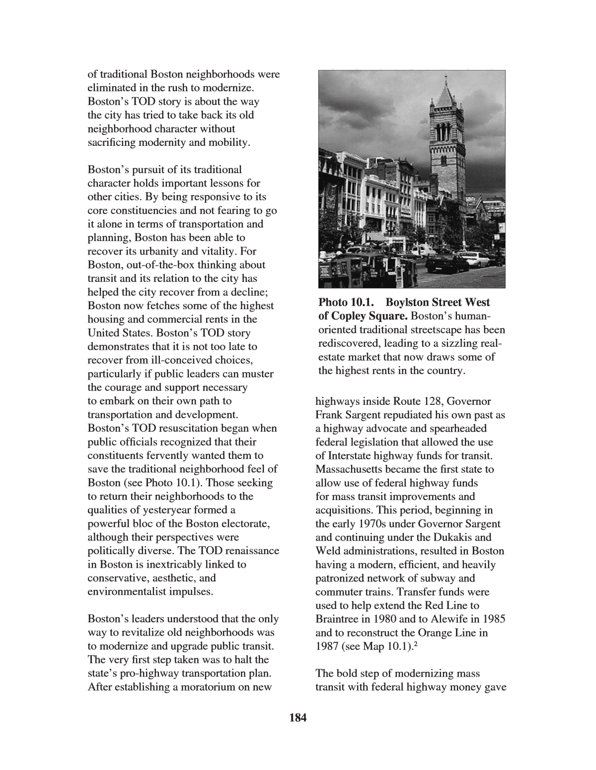
183 Chapter 10 TOD in Boston: An Old Story with a New Emphasis Boston is an ideal transit story, with a long, rich tradition of transit-shaped development and a healthy present-day economy that is receptive to TOD. National comparisons show that the city of Boston ranked third in transitâs market share for commuting at 33%, slightly behind Washington, D.C. And unlike Washington, which has witnessed a gradual loss of population, Bostonâs population grew by over 3% between 1990 and 2000. In addition, many of Bostonâs suburbs, such as Brookline, Somerville, Cambridge, Chelsea, and Malden, experience significant transit usage. This is a city that has grown up around public transportation, so TOD is not considered something particularly novel, but rather business as usual. In recent years, greater Boston has enjoyed a robust economy. PricewaterhouseCoopers, in the report Emerging Trends in Real Estate: 2003, ranked Boston sixth in terms of investment and seventh for development, buoyed by a 24-hour vibrancy and a diversified economy.1 The investment community has turned bearish on fast- growing sprawling suburbs, worried about traffic, lack of planning, banal commercial strips, and premature aging of housing stock. Suburban real-estate investments, the report warns, are subject to âbecoming little more than commodity investments over time.â There is a growing appreciation for the need to âcreate enduring main streets and real places.â Not only are many suburbs ânot cool anymore,â they also âdonât workâ very well. Boston, on the other hand, wins kudos for its multifaceted economy of financial services, health care, technology, and education, which âcycle independently.â While tourism continues to be hard hit since 9/11, and no massive recovery is expected for the office market, barriers to entry of new products protect investors, and apartment rents, while softening a bit, continue to sizzle. Boston Recovers Its Traditional Neighborhood Roots Boston, as one of the oldest cities in the United States, has a traditional layout that was developed along TOD principles long before the term entered the mainstream planning lexicon. When this type of development fell out of favor in the 1950s and 1960s among planners, politicians, and the private sector, Boston entered, like all U.S. cities, the full throttle race to build more highways. During the same time period, the city jumped on board the same kind of âscorched-earthâ urban renewal policies that were in vogue elsewhere. In the interest of creating a modern government-center area, smaller-scale traditional buildings were cleared and properties assembled to create monolithic buildings isolated in a vast space that were subject to New England winds and devoid of street life after work. Old- timers still remember with a certain amount of resentment how entire swaths
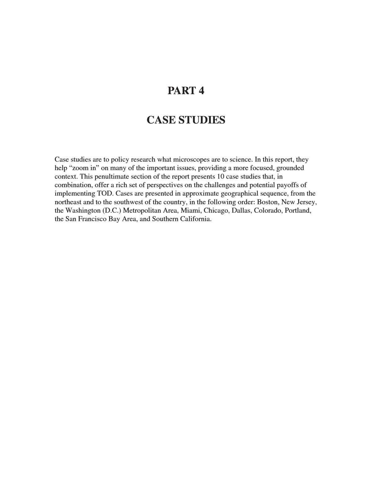
of traditional Boston neighborhoods were eliminated in the rush to modernize. Bostonâs TOD story is about the way the city has tried to take back its old neighborhood character without sacrificing modernity and mobility. Bostonâs pursuit of its traditional character holds important lessons for other cities. By being responsive to its core constituencies and not fearing to go it alone in terms of transportation and planning, Boston has been able to recover its urbanity and vitality. For Boston, out-of-the-box thinking about transit and its relation to the city has helped the city recover from a decline; Boston now fetches some of the highest housing and commercial rents in the United States. Bostonâs TOD story demonstrates that it is not too late to recover from ill-conceived choices, particularly if public leaders can muster the courage and support necessary to embark on their own path to transportation and development. Bostonâs TOD resuscitation began when public officials recognized that their constituents fervently wanted them to save the traditional neighborhood feel of Boston (see Photo 10.1). Those seeking to return their neighborhoods to the qualities of yesteryear formed a powerful bloc of the Boston electorate, although their perspectives were politically diverse. The TOD renaissance in Boston is inextricably linked to conservative, aesthetic, and environmentalist impulses. Bostonâs leaders understood that the only way to revitalize old neighborhoods was to modernize and upgrade public transit. The very first step taken was to halt the stateâs pro-highway transportation plan. After establishing a moratorium on new highways inside Route 128, Governor Frank Sargent repudiated his own past as a highway advocate and spearheaded federal legislation that allowed the use of Interstate highway funds for transit. Massachusetts became the first state to allow use of federal highway funds for mass transit improvements and acquisitions. This period, beginning in the early 1970s under Governor Sargent and continuing under the Dukakis and Weld administrations, resulted in Boston having a modern, efficient, and heavily patronized network of subway and commuter trains. Transfer funds were used to help extend the Red Line to Braintree in 1980 and to Alewife in 1985 and to reconstruct the Orange Line in 1987 (see Map 10.1).2 The bold step of modernizing mass transit with federal highway money gave 184 Photo 10.1. Boylston Street West of Copley Square. Bostonâs human- oriented traditional streetscape has been rediscovered, leading to a sizzling real- estate market that now draws some of the highest rents in the country.
Boston the modern infrastructure necessary for neighborhood TOD-based revitalization. A second crucial decision for Bostonâs current TOD was Governor Dukakisâs revitalization of the Massachusetts Bay Transportation Authority (MBTA) services. Commuter-rail lines were reopened, existing lines within Boston were extended and renovated, and new rolling stock was acquired (see Map 10.2).3 A third factor in TODâs resurgence was the negotiated parking agreement with the U.S. Environmental Protection Agency (EPA) that froze the number of allocated spaces in Boston at 1973 levels (approximately 35,500 spaces). This prevented excess parking from being built in Bostonâs urban core (see Text Box 10.1). Finally, new MBTA stations in Boston were built without parking, which promoted TOD by putting pedestrian accessibility above automobile convenience.4 These public policies had the cumulative effect of producing a more cohesive urban design. The policies adopted 20 to 30 years ago must also be given credit, at least partially, for Bostonâs phenomenal residential real-estate market. Bostonâs leaders recognized that the private sector would only build along TOD principles if modern, clean, and efficient transport were available. Financial constraints imposed by lenders meant that the public sector had to take the risks necessary for the city to rejuvenate. After it was clear that public officials were committed to a modern transit infrastructure, 185 Map 10.1. MBTA Subway Map. Source: MBTA.
the private sector enthusiastically embraced TOD. Bostonâs TOD Toolbox Boston does not so much plan for TOD as it does find ways to maintain its traditional urban fabric, a fabric that has been transit oriented from the beginning, having been built for the most part around trolley and streetcar lines. Almost all of Boston proper is within 1â4 mile of one or more transit stations. Bostonians are used to this and expect the city to maintain this status quo. Since the traditional neighborhood appeals to the entire Boston political spectrum, it has been in Bostonâs political leadersâ interest to both sustain and expand it. These neighborhoods are characterized by a pedestrian orientation; an intertwining of business, retail, and residential buildings at high densities; and close access to public transportation. Thus, instead of pursuing grand TOD schemes, Bostonâs planners use small, subtle tools to make sure the system continues to function in a transit- oriented manner. Today, Boston-style TOD is a proven commodity that developers and financiers are eager to deliver, and importantly for the city, an idea that does not have to be sweetened with lots of public money to convince developers and banks to deliver. Bostonâs modus operandi is generally to encourage TOD through zoning and other types of regulations and then sit back and let the market deliver the product.5 In addition, since Bostonâs core is highly accessible by transit, and most of the downtownâs 186 Map 10.2. MBTA Commuter-Rail Map. Source: MBTA.
EPA Parking Freeze The 1972 Clean Air Act had a profound and lasting effect on Bostonâs recent development. In the early 1970s, city leaders negotiated two agreements with the EPA to mitigate air pollution in the Boston area. This resulted in the formation of the Boston Air Pollution Control Commission, which was put in charge of implementing the agreement. The most noteworthy part of the agreement was that Boston was allowed to freeze its parking requirements at 1973 levels plus 10%. This cap is strictly enforced and includes all general public parking in Boston proper. It allows the Boston Air Pollution Control Commission to grant exemptions in only two cases: for private off- street parking based on need (e.g., residential, hotel guest, and employee) and residential parking, if the developers can demonstrate that the general public will be excluded from these spaces. Between 1977 and 1997, the total number of parking spaces grew by only 9%, from approximately 51,000 to 59,100 spaces.6 The cost of parking in Boston as compared with other American cities reflects the impact. Boston, at an average of $408 per month for parking, has the second most expensive parking in the nation (the most expensive is midtown New York). (The U.S. average is $147 per month.) The freeze has at times been politically unpopular, and developers often complain publicly, but in private they concede that they enjoy the higher profitability of not having to include parking in their projects. The parking freeze is next to impossible to lift because of a legal requirement imposed by the EPA that requires the city to offset the environmental impact of eliminating the freeze. No one in Boston, as yet, has found a politically palatable alternative to the freeze. The popularity of parking caps is the result of its beneficial results. Besides improving air quality, it has produced an unexpected benefit: increased development activity. By making parking optional, developers are able to lower the cost of urban projects and thus more easily obtain financing. The parking freeze has also allowed the city to grow without disrupting the urban fabric with more automobiles, parking garages, and surface lots. Today, the cityâs narrow pedestrian-oriented streets are teeming with life. After Boston enacted the parking freeze in 1973, Portland, Oregon, and Los Angeles sought to follow suit. However, Congress stepped in and passed legislation forbidding the EPA from reaching parking freeze agreements with cities. Without the option of reaching agreements with the EPA, the ball bounced back into the citiesâ courts. From the congressional action forward, cities have had to affirmatively vote to adopt parking freezes, which a number of close-in cities around Boston did, most notably Cambridge. Former Massachusetts Transportation Secretary Fred Salvucci asserts that no public policy has had such a dramatic effect on Bostonâs development as the parking freeze of 1973.7 The parking freeze allowed Boston to shift its focus to mass transit. The freeze has also helped Boston to become one of the largest metropolitan areas that is in compliance with federal clean air standards. As importantly, the freeze contributed to Bostonâs human-scale ambience, producing handsome profits for developers in the process. Text Box 10.1
real-estate market is red-hot, most development occurring in central Boston is both transit oriented and lucrative, eliminating the need for subsidies. While Bostonâs legacy of TOD is in no danger today, it was once threatened by new highways planned for the city. Boston was saved by forward- looking state and city officials who recognized that their transit systems could not survive in a system where the federal government almost exclusively funded roads. A plan was devised to siphon funds from Massachusettsâs federal highway funds and use them instead for transit improvements. Moreover, unique among cities, Boston focused its transit dollars on Bostonâs core rather than on suburban commuter lines. Boston was thus able to maintain high-quality transit services and a semblance of a dense urban grid. The city of Boston and in particular the cityâs redevelopment authority, has over the years sought to strengthen transitâs presence by using regulations, incentives, and other tools. For example, the city placed a cap on downtown parking; requires active ground-floor uses; promotes pedestrian-friendly streetscapes; and with large projects, requires contributions for infrastructure improvements. The city also encourages a jobs/housing balance around transit stations, which helps to maintain long- term economic health in all areas of the city and ensure extensive use of transit services both day and night.8 Of the tools the city of Boston possesses, one of the most commonly used has been Article 80 of the cityâs zoning code, which concerns the review and approval of new developments. As part of Article 80, according to John Dalzell, Senior Planner with the Boston Redevelopment Agency, the city requires projects of 50,000 square feet and or more to prepare transportation mitigation plans as a precondition to approval.9 The city has encouraged large developments to make use of existing transit facilities and, if possible, to help with renovating or redesigning stations to better align entrances to the development. Other mitigation measures used to gain approvals include subsidizing employeesâ MBTA passes, making provisions for shuttle buses to outlying transit stations, and provision of storage facilities for bicycles.10 The Longwood Medical Area is an example where Boston mitigations were required. The Longwood Areaâs institutions, which include Harvard Medical School and other major teaching hospitals, coordinate the provision of shuttle bus and other multi- modal options in the Longwood Area, which is slightly isolated from surrounding mass transit services. As a result, very few workers today drive to the Longwood Medical Area.11 A commonly used non-regulatory tool in Boston has been focusing economic development dollars on and adding police officers to areas around transit stations that are perceived to be under- serviced and dangerous. For some areas, this has prodded developers to build and rehabilitate residential buildings around stations. The final piece of Bostonâs TOD toolbox is tax foreclosure. Boston consolidates and markets foreclosed properties aggressively to promote TOD. Since tax foreclosure is the main source of land that comes to the city, it offers the best 188
chance for promoting TOD in underdeveloped communities. Generally, foreclosed properties are abandoned or, if active, need improvements and safety repairs. Depending on the state of a building, the city performs the necessary work, including safety repairs, environmental remediation, or demolition of the building. Although the city is required to seek payment of back taxes and fees, which can include the cost of any improvements, usually a developer who purchases a property ends up with a subsidized parcel.12 Two other areas where the market needs help with city subsidies are affordable housing and elderly housing. Affordable housing is usually done on a small scale in conjunction with neighborhood community development corporations (CDCs). An example is Phase II of Back of the Hill, just completed, which included 50 units of infill affordable home ownership and rental housing within 1â4 mile of the Green E Line.13 The other problem area, elderly housing, has become synonymous in Boston with what is called âoverhousing.â Overhousing is the result of an overabundance of multifamily buildings in a neighborhood that once contained 8 to 10 people in a family, but now only houses 1 or 2 elderly residents. Often, the elderly owners of these buildings do not rent the extra rooms or floors for fear of problem tenants. As a result, elderly Bostonians are increasingly isolated socially from the rest of the community, and at the same time, their neighborhoods and transit stations suffer from the resulting de-densification.14 The city is addressing the problem by building senior housing in these types of communities. Once seniors are able to move into senior communities, under- utilized multifamily housing can be more fully occupied. Finally, the discussion thus far has been on tools used to promote TOD. However, Boston is also seeking to expand its transit system, even in bad economic times, to ensure the city has the infrastructure necessary to handle a growing city population. Boston has focused its future transportation plans on linking the âspokesâ of the cityâs subway system that radiate from downtown to make commuting faster and more efficient for its residents. As part of this plan, the most significant near-term new transportation investment in Boston is the opening of four new stations on what will be called the Fairmont Line. These stations are to be built along an existing commuter line and will âunlockâ southeastern Boston, which has remained relatively isolated because of its lack of a good connection with the remainder of the cityâs job and retail market.15 Since the areaâs real estate is not as coveted as elsewhere in the city, the development around the Fairmont Line transit stations will initially be subsidized. MBTA, Joint Development, and TOD The conventional definitions of TOD and joint development do not fit easily in Boston, since the concepts have largely been conceived for the 20th-century suburban city prevalent in most of the country. For Boston, TOD was once the only type of development. It could be argued that almost the entire Boston core is TOD in that most longstanding buildings and neighborhoods were built around old trolley and interurban lines. Likewise, joint development as it is commonly understoodâthe selling or 189
leasing of transit-agency land to a developer in return for a stake in the development projectâis not common in Boston, though much of the cityâs development is physically oriented to transit stations. While Boston owes much of its TOD pedigree to its age, history also explains why joint development has not occurred very frequently. Old transit systems like Bostonâs never acquired much land around stations because they pre-dated parking lots. This does not mean the MBTA has simply stood by and watched over the years, however. The agency has sought to maximize its influence on development. One step it took was to contract with a private real-estate service company to identify opportunity areas for joint development. Since 1996, the 23 stations where joint development could occur have been identified, with 3 or 4 of them considered to be good possibilities.16 The MBTA has been most proactive in forming equity partnerships (e.g., the agency leases or sells its land near a station to a developer and takes an equity interest in the development). In Boston, this occurs on a smaller scale than it does in the agreements typically found at younger transit agencies. For example, at the Ashmont Square Station, the MBTA entered into an agreement with a developer to build 150 units of housing on agency land. Proceeds from the development went toward construction of a new parking structure with 5,000 spaces near the station.17 Most real-estate activity at MBTA stations is not joint development, but rather is property management. Frequently, the MBTA will allow developers to use MBTA property to enhance pedestrian connections (e.g., to a retail shop) while also advancing MBTAâs goal of increasing ridership. Unlike similar arrangements in the station-connection program in Washington, D.C., there is no monetary exchange between the private and public sectors. In Cambridge, the city and the MBTA negotiated with the developer of CambridgeSide Galleria, an urban mall, to run shuttle buses every half hour from the two âTâ stops at Kendall Square and Lechmere Square located nearby. Presently, nearly 50% of the shoppers at the CambridgeSide Galleria walk or use transit. Another example of Boston-style joint development was the tripartite agreement among the MBTA, Massport, and the developer of the World Trade Center in South Boston to construct a new underground Silver Line BRT station at the World Trade Center complex. Each party brought something to the table that the other parties wanted. Massport owned the land, the developer owned the World Trade Center buildings, and the MBTA had the power to choose the location of the station. The essence of the agreement concerned the sharing of costs and responsibilities for the station among the three parties. Massport provided the infrastructure, the developer bore the cost of construction, and the MBTA delivered the rail service. Both Massport and the developer were able to add value to their investments by vastly increasing access to the building, and the MBTA was able to increase ridership while defraying a large portion of the cost of a new station.18 While the MBTA has been working on joint development independently, it has 190
also gotten a renewed commitment from the state of Massachusetts in the form of the Office of Commonwealth Development. Formed by the newly elected Governor, Milt Romney, the new office is headed by Douglas Foy, a TOD advocate. As part of its work, the Office of Commonwealth Development has formed a TOD task force that includes the Secretary of the Environment, the Secretaries of Transportation and Energy, and the MBTAâs real-estate planner. The charge of the task force is to formulate ways to promote TOD in Massachusetts. The hope is that this unprecedented partnership will help Massachusetts secure federal funding for new rail starts.19 The Boston Economy and the Real-Estate Market The major players in the Boston economy tend to sort themselves out by location. Financial-services, law, and accounting firms drive the downtown and Back Bay submarkets, whereas venture capitalists and technology firms are concentrated in Cambridge. The Route 128 corridor, dubbed the âHigh-Tech Corridor,â is also home to healthcare, manufacturing, finance, retail, and general-business firms. The largest technology presence in the area is in the more distant suburban I-495 markets, focused on the beltway corridor.20 While it is diversified in terms of industry mix, Bostonâs economy remains volatile. The area has captured a large share of venture capital funds in recent years, and it continues to attract cutting-edge technology ventures, both of which are highly susceptible to market swings. By early 2003, a deteriorating market for office space pushed vacancy rates to over 17%. Easy Transit Connections, Tough Development Sites Most of Bostonâs historic buildings are located on or near one of MTBAâs four subway lines. Early developers routinely sought out sites served by transit. The historical blending of buildings and public transportation means that transit is imprinted in the communityâs DNA, as represented by quaint transit-served venues like Fenway and the Boston Pops. To Bostonians, transit is an inseparable part of the urban landscape. Boston developer Richard Reynolds, principal of Spaulding & Slye Colliers, volunteered, âWe never have to think about it.â Pam McKinney, principal of the development consulting firm, Byrne McKinney & Associates, Inc., says that in Boston, âTransit is bred in the bone.â In the 1990s, Boston encouraged development around the North and South Station areas, major commuter-rail destinations with good connections to the subway and buses. Table 10.1 lists some of the TOD projects under construction or completed. Many are building rehabilitations and infill projects. Bostonâs list of TODs will continue to expand as subway modernization programs and station-area enhancements like the North Station/Fleet Center take form (see Text Box 10.2). Bostonâs historic neighborhoods and quaint buildings enjoy strong appeal, and rents remain high. One challenge has been how to serve the needs of a modern business or an upscale resident, accustomed to vastly larger spaces and a diversity of services, on a street grid and lot pattern more appropriate to a craftsman than a mutual fund manager. Copley Place and Prudential Center were pioneering 1960s solutions that broke the limits of small-scale properties but 191
192 involved huge public outlays to assemble the land needed for such large building scales. Bostonâs âBig Digâ will provide numerous opportunities for large-lot transit-supportive redevelopment in years to come (see Text Box 10.3). Revitalization: The Liberty Tree Building and the Combat Zone Invoking the name of a revered icon of early Boston, the Liberty Tree building was erected in 1850 near a large elm tree that stood as a symbol of resistance to British rule during the Revolutionary War. The location was named the Combat Zone for the military personnel who had uniforms tailored there, but it later was notorious as the center of Bostonâs adult entertainment district. By the early 1990s, the Liberty Tree building was vacant save for an adult bookstore; a concerted drive to turn the neighborhood around drew private interest in renovating the building. Among the buildingâs assets is direct stairway access to the subway system; Project Size (sq. ft.) Use(s) Status Back Bay Station 1,000,000 Luxury Condos, Hotel, Parking Garage, Retail Under construction Ruggles Station 300,000 Office Park Completed in 1995 World Trade Center 1,300,000+ Hotel, Office Towers Near completion Fan Pier 3,000,000 Hotel, Multifamily Housing and Condos, Office, Museum, Parks Fully Permitted Northpoint 5,000,000 Office, Extensive Residential, Park Planning stages Millenium Center-Ritz Carlton 1,400,000 Mixed Use Completed 2003 Alewife Brook 1,600,000 Office, Residential Completed in 1988 Table 10.1. TOD Projects in Boston however, building renovation required removing part of the subway entrance. A mezzanine was built on the fourth floor, adding 5% more space to the then 45,000 square feet within the building footprint. The exterior of the building was restored to a 19th-century façade (see Photo 10.2).21 The Liberty Tree buildingâs superior location above the subway station, its architectural beauty, and a tight office market in Boston offset the risk of being located in a less desirable part of the city. The buildingâs renovation proved to be the turning point for the Combat Zone. Governor Weld offered a state agencyâthe Registry of Motor Vehicles (RMV)âas a lead tenant for the refurbished building. With street life active from day workers and customers patronizing spin-off businesses like delis and retail shops, other buildings were soon targeted for renovation. Numerous renovations and conversions took place in the Combat Zone, including new office space, dormitories, retail space, and the massive Millennium Place mixed-use project.
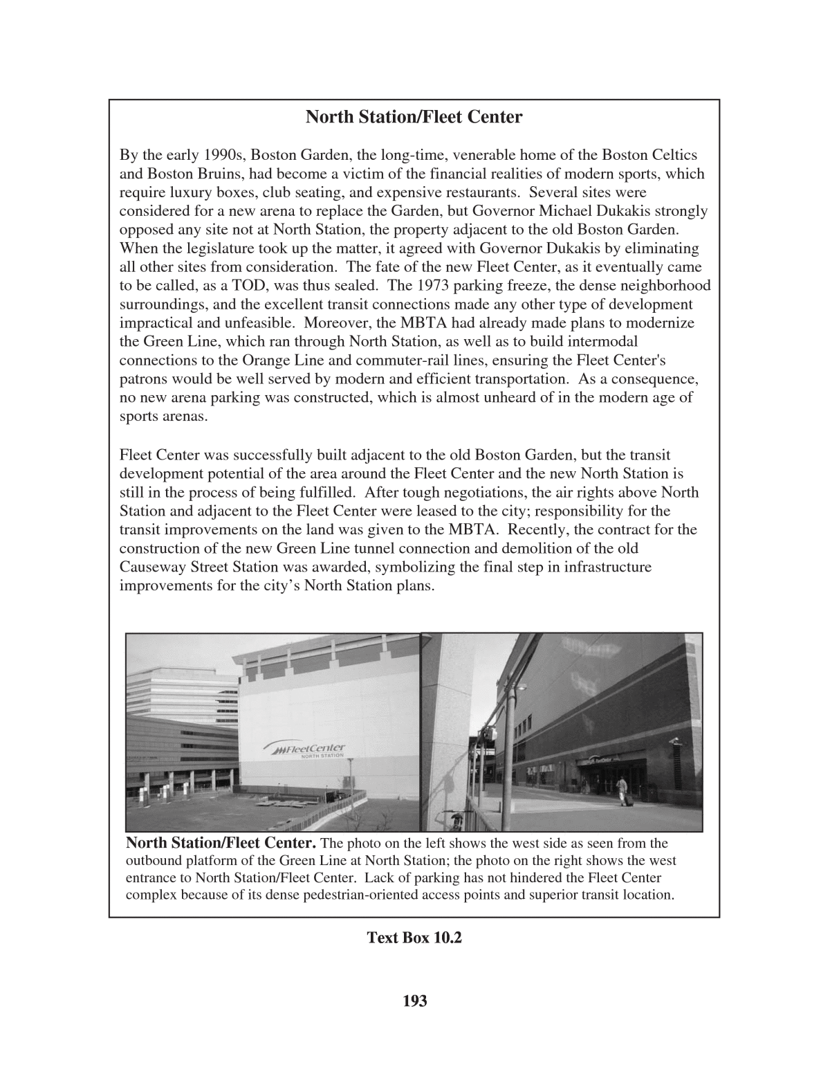
193 North Station/Fleet Center North Station/Fleet Center. The photo on the left shows the west side as seen from the outbound platform of the Green Line at North Station; the photo on the right shows the west entrance to North Station/Fleet Center. Lack of parking has not hindered the Fleet Center complex because of its dense pedestrian-oriented access points and superior transit location. By the early 1990s, Boston Garden, the long-time, venerable home of the Boston Celtics and Boston Bruins, had become a victim of the financial realities of modern sports, which require luxury boxes, club seating, and expensive restaurants. Several sites were considered for a new arena to replace the Garden, but Governor Michael Dukakis strongly opposed any site not at North Station, the property adjacent to the old Boston Garden. When the legislature took up the matter, it agreed with Governor Dukakis by eliminating all other sites from consideration. The fate of the new Fleet Center, as it eventually came to be called, as a TOD, was thus sealed. The 1973 parking freeze, the dense neighborhood surroundings, and the excellent transit connections made any other type of development impractical and unfeasible. Moreover, the MBTA had already made plans to modernize the Green Line, which ran through North Station, as well as to build intermodal connections to the Orange Line and commuter-rail lines, ensuring the Fleet Center's patrons would be well served by modern and efficient transportation. As a consequence, no new arena parking was constructed, which is almost unheard of in the modern age of sports arenas. Fleet Center was successfully built adjacent to the old Boston Garden, but the transit development potential of the area around the Fleet Center and the new North Station is still in the process of being fulfilled. After tough negotiations, the air rights above North Station and adjacent to the Fleet Center were leased to the city; responsibility for the transit improvements on the land was given to the MBTA. Recently, the contract for the construction of the new Green Line tunnel connection and demolition of the old Causeway Street Station was awarded, symbolizing the final step in infrastructure improvements for the cityâs North Station plans. Text Box 10.2
Rejuvenation: Back Office Space with a Front Office Location East-coast cities are filled with aging buildings plagued with safety and environmental problems. The State Street Bank Building, in the heart of Bostonâs financial district, is one of these buildings (see Photo 10.3). Built in the 1960s, its exterior design no longer in vogue, and years of deferred maintenance becoming increasingly evident, the building was about to slip into the less valuable Class B status. Moreover, the discovery of asbestos increased the cost of bringing the building back to its original status. Undeterred, the buildingâs owners began a $98-million rehabilitation project with the goal of retaining tenants being lost to newer Class A buildings. The first anchor tenant for the newly refurbished building was Fidelity Investments, one of Bostonâs thriving mutual fund companies, which had been looking for back office space in the suburbs. The buildingâs quality refurbishment, central location, and good transit access gave it an edge over its suburban competitors.22 The State Street buildingâs ability to retain and attract tenants at Class A rents and maintain high occupancy levels gave renovation a much needed boost in downtown Boston. Ease of transit access gave it a great advantage over newer suburban rivals dealing with 194 North Station/Fleet Center The Only Entrance to the Elevated Green Line at North Station (Left Photo). East Entrance to the North Station/Fleet Center (Right Photo). A station-area plan for North Station/Fleet Center is nearing completion. Transit improvements and completion of the Big Dig will make the North Station TOD neighborhood the gateway for the northern approach to the Rose Kennedy Greenway development (being constructed over the Central Artery Tunnel). Although it was an arduous task to negotiate the title of the land between the city and state and involved extremely complex engineering and design to accommodate the new Fleet Center and modernized transit lines, the effort appears to have paid off. Real-estate insiders and local and state officials cite North Station as Bostonâs one âcanât-missâ future TOD.26 Text Box 10.2 (Continued)
195 The Big Dig: New Land for TOD Set for completion in 2005, the placement of Bostonâs Central Artery underground ranks as the largest, most expensive highway project in U.S. history. The project has been key to the redevelopment of the South Boston Waterfront as well as the reunification of the Financial District with the Downtown Waterfront. Because major rail corridors parallel the underground artery, once the Big Dig is completed, access between rail stops and major waterfront destinations will be materially enhanced. When it was originally designed, the Central Artery was meant to handle only local traffic going in and out of Boston. An inner belt was to be built that would take automobiles around the city. Because the construction of the Central Artery displaced 20,000 residents and destroyed 1,000 residential and commercial buildings, strong community opposition led to the abandonment of the inner beltway project. As a result, the Central Artery has been handling both local and through traffic for over 40 years, producing an accident rate four times the national average. The tunneling of the Central Artery will provide Boston with more than 30 acres of new open space, parks, and commercial development. All of this bodes favorably for a waterfront that is attractive to pedestrians and transit users. Central Artery Construction Project (the âBig Digâ) Source: Massachusetts Turnpike Authority. Text Box 10.3
196 increased gridlock on Bostonâs freeways. Main Street and TOD Another important force in Bostonâs TOD renaissance has been its cadre of local nonprofit organizations that specialize in smaller neighborhood-scale development projects. These groups, however, rarely communicated or coordinated activities. This changed when Boston became the first large U.S. city to enroll in the National Trust for Historic Preservationâs Main Street Program. The Trustâs program organized the city into 19 neighborhoods. The premise of the program was that in order to receive help, each neighborhood had to demonstrate that residents, merchants, and nonprofit institutions would work together. They also had to find a corporate âbuddyâ that would invest money and personnel in the program. The program made immediate inroads. It won the National Trustâs Great American Main Street Award. In four years, the program produced 313 new businesses, 2,326 (net) new jobs, 46,500 Main Street volunteer hours, 120 storefront improvements, and $40 million in new commercial and residential construction (see Photo 10.4).23 Before these improvements, most of the participating neighborhoods were considered crime ridden and thus Photo 10.2. Liberty Tree Building with MBTA Stop. The Registry of Motor Vehicles (RMV) is located at street level. The RMVâs success in breathing life back into the neighborhood led to the decision by the Commonwealth to locate the transportation building in Park Square downtown. Both were a part of the Commonwealthâs strategy to pioneer locations of government agencies to stabilize conditions for the private market. Photo 10.3. Renovated State Street Bank Building. The refurbished buildingâs comeback typified the spectacular performance of the Boston office market and real-estate market in general in the 1990s.
197 drew scant interest from the development community. The Main Street Program has also become a key component of Bostonâs comprehensive TOD strategy. Most of the Boston Redevelopment Authorityâs TOD work centered on revitalizing retail centers in rail-served neighborhoods, a problem the Main Street Program has been particularly effective in solving. Often, lack of supermarkets and other major retail outlets are a primary deterrent to reinvestment. The Main Street Programâs success at solving this retail vacuum in many places has resulted in vibrant TOD neighborhoods offering all the basic services, along with some specialty retail, within a short walking distance of transit stations. The Main Street Program has also helped Boston maintain a housing/jobs balance that is considered a crucial part of its long-term TOD strategy.24 South Station: Development Around Commuter Rail While much of Bostonâs TOD story involves its subway system in the urban core and inner suburbs, the region also has an extensive commuter-rail system that links Boston with far-flung suburbs. Historically, there has been a disconnect between the two. While there has been unbridled enthusiasm for TOD in downtown Boston, support for TOD in the outer suburbs is lukewarm at best. This has led to an interest in concentrating development at major commuter-rail transfer stations. South Station is the most successful example of this effort to date. Constructed in 1898 with large windows and a grand waiting room, South Station faced the wrecking ball in 1974. The Commonwealth intervened under then newly elected Governor Dukakis and halted demolition on the grounds of historical preservation. Federal funds were later secured to restore the beautiful building as an intermodal facility hosting subway, commuter, and regional trains as well as Bostonâs spoke system of buses. The $29-million renovation was completed in 1989, with the bus portion of the station completed in the mid-1990s. The Photo 10.4. Main Street in Roslindale Village Neighborhood. The Main Street program focuses on improved storefront façades and improved streetscapes to enhance pedestrian access. The results have been a boon for participating businesses located near transit stops.
refurbished building was designed with a structural support to allow an office tower to be built when market demand permitted (see Photo 10.5).25 Today, South Station is poised to realize its full TOD potential. Two developments, Russia Wharf and 500 Atlantic Avenue, are planned for parcels near South Station. Russia Wharf will be a mixed-use project with hotel, residential, and office buildings totaling over 1 million square feet and a 512-space parking structure built underneath. 500 Atlantic Avenue will contain a 420-room hotel and a 141-unit condominium for a total of 729,200 square feet, with a 375-space underground parking garage. In the course of two decades, the once rundown area around South Station has transformed into a bustling center of activity. South Station, according to Al Raine, an assistant in the state office of planning under Governor Dukakis explained, happened only when the city and the state took a long-term perspective. In his estimation, it was vital that the city established a clear framework of public investments and regulations with plans that provided specific timelines. The plan for South Station also clearly shaped the densities and edges of the spaces around the station. All this was necessary to create the transparency that both developers and the public needed to see the vision through to fruition.27 South Boston Waterfront: The Future Transit Neighborhood The 1,000 acres of the South Boston Waterfront (or Seaport District) offer the city of Boston a chance to create the first new urban neighborhood oriented to transit in decades. The key to TOD in 198 Photo 10.5. South Station Main Entrance and Future Rendering. The Neoclassical building (top photo) that houses the station and the proposed Atlantic Avenue development (bottom photo) behind the station serve as anchors for the burgeoning commercial and office district targeted for suburban commuter traffic.
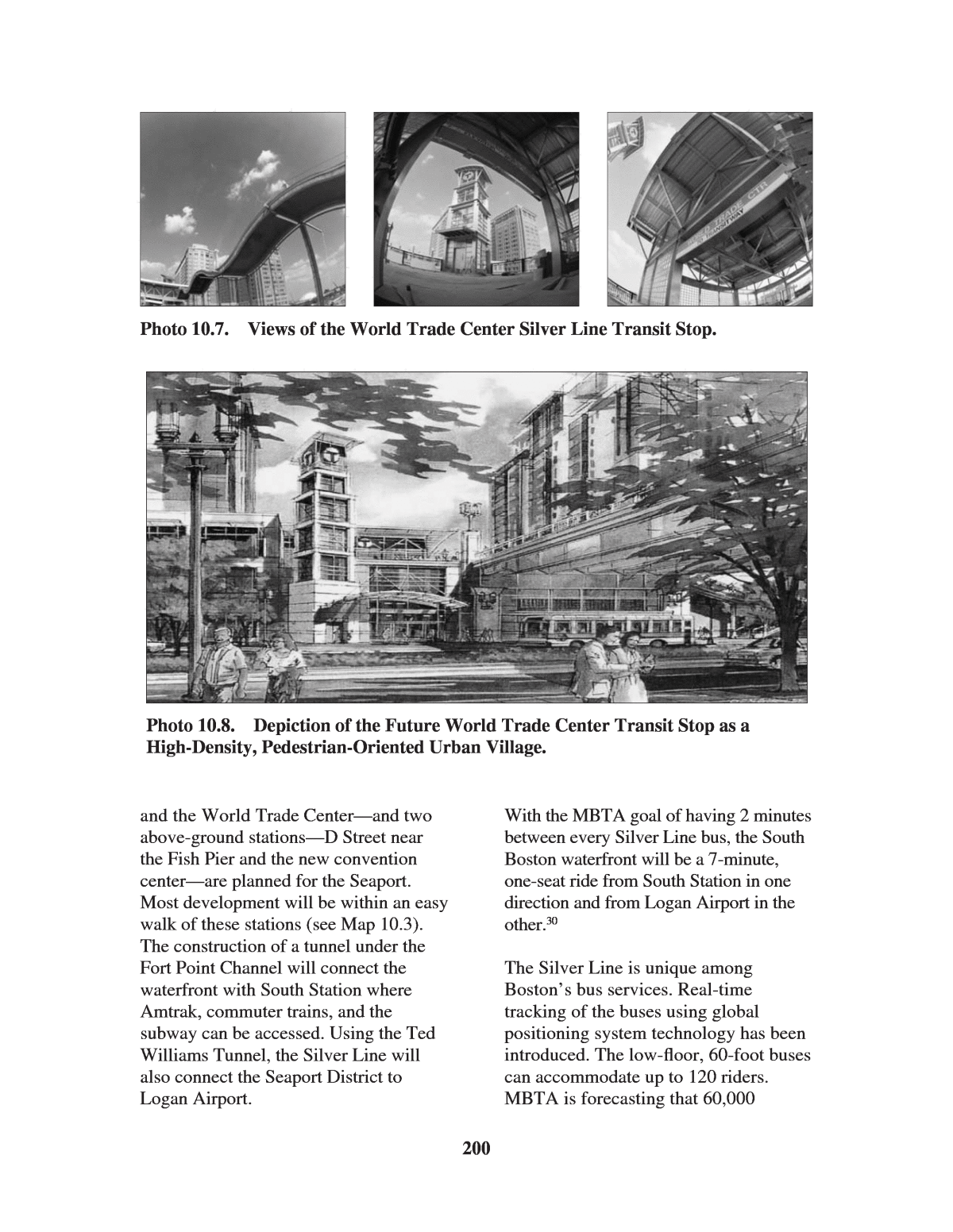
199 the Seaport District is the creation and utilization of MBTAâs Silver Line, an underground dedicated busway linking South Boston Waterfront to Downtown Bostonâs South Station. The Silver Line is greater Bostonâs first BRT service. The Seaport District was bustling with activity until the mid-1970s, when the marine and navy industries either closed or moved elsewhere. To make matters worse, the construction of the Central Artery formed a physical barrier between the Seaport and downtown Boston. The isolation of the area contributed to making the South Boston Waterfront a site of underutilized and underdeveloped land. For most people, the South Boston Waterfront has been a forgotten place.28 There have been redevelopment efforts in the Seaport District in the past, but none have been focused on transit opportunities. The TOD plan will be the largest and most comprehensive redevelopment effort to date for the waterfront. The aim is to create a lively, 24-hour, transit-oriented community (see Photo 10.6).29 The success of transforming the Seaport into a TOD depends on the organization of transit in the neighborhood. For financial reasons, a decision was made to use BRT in place of extending the subway line to the South Boston Waterfront. The MBTA created the Silver Line, a dual-mode/dual-propulsion system. It operates as an underground electric bus around the Seaport, but becomes a low-emission bus traveling in bus-restricted lanes on city streets (see Photos 10.7 and 10.8). Two underground stationsâCourthouse Photo 10.6. Aerial View of South Boston Waterfront. Opportunities for cities to start over again on such a large tract of land so close to the central core are rare indeed. Boston has ambitious plans to make the Seaport District the crown jewel of its TOD renaissance by making the District a high-density urban village and tourist attraction served by a multimodal transit system.
200 and the World Trade Centerâand two above-ground stationsâD Street near the Fish Pier and the new convention centerâare planned for the Seaport. Most development will be within an easy walk of these stations (see Map 10.3). The construction of a tunnel under the Fort Point Channel will connect the waterfront with South Station where Amtrak, commuter trains, and the subway can be accessed. Using the Ted Williams Tunnel, the Silver Line will also connect the Seaport District to Logan Airport. With the MBTA goal of having 2 minutes between every Silver Line bus, the South Boston waterfront will be a 7-minute, one-seat ride from South Station in one direction and from Logan Airport in the other.30 The Silver Line is unique among Bostonâs bus services. Real-time tracking of the buses using global positioning system technology has been introduced. The low-floor, 60-foot buses can accommodate up to 120 riders. MBTA is forecasting that 60,000 Photo 10.7. Views of the World Trade Center Silver Line Transit Stop. Photo 10.8. Depiction of the Future World Trade Center Transit Stop as a High-Density, Pedestrian-Oriented Urban Village.
passengers will use the Silver Line each workday. The Seaport District is also slated for high-density residential development. Two sites are planned for over 1,100 owner-occupied units (see Photo 10.9). More housing will be needed, however, if the Seaport District is to become a true 24/7 neighborhood. The commercial and open spaces of the Seaport District are moving along at a faster pace than residential space. The centerpiece of the District will be the Boston Convention & Exhibition Center (BCEC), with 550,000 square feet of contiguous exhibit space and an adjoining hotel. The site covers 60 acres and, if successful, will generate a high level of evening and weekend activity, minimal private automobile traffic, and extensive pedestrian spillover to hotels, restaurants, and stores. One of the Silver Lineâs underground stops is at the BCEC. Bostonâs commitment to making the Seaport District oriented to transit instead of adjacent to transit is evidenced by the parking limits imposed on the area. Before it has even been fully developed, the Seaport is already characterized as having âparking ratios typical of those found in mature, transit- intensive downtowns.â31 The Fan Pier site is offering only 2,280 off-street parking spaces, or 0.85 spaces per 1,000 square feet of development. Such low parking ratios ensure that automobiles do not have priority over transit in the Seaport. Not all TOD initiatives in 201 Map 10.3. Walkable 1â4-Mile Radii Surrounding Silver Line Transit Stations in the Seaport District. The line will connect the isolated Seaport District with multimodal South Station. Source: MASSPORT.
Boston are nodal in form. Plans are under way to create a transit corridor that orbits the central city. See Text Box 10.4 on the planned Urban Ring of TOD. Lessons Learned Boston provides five important lessons for other jurisdictionsâ TOD development goals. First, a strong market makes many things work. Boston is such a desirable city for migrants and an attractive place for business that planning for transit helps reinforce a generally favorable climate. It also gives planners some leverage over development that might not occur in less desirable communities. Planning is important, but a strong market can help raise all boats in the harbor. Second, strong public-sector leadership is needed to promote TOD, even in a strong market. The Boston case shows that even if a city was built around transit, and transit is ingrained in its culture, it cannot rest on its TOD laurels. Public officials and private developers must work together to bring a more contemporary, market-sensitive version of TOD to the city and its surrounding communities. Backsliding is prevalent in America, and there is a strong motivation to do things that are easy rather than those that are right. In Bostonâs case, this has meant that when the private sector cannot lead, public officials must provide leadership on TOD to reassure lenders that their investments are secure. The third lesson Boston provides is that a significant part of leadership is helping to make projects work financially. In Boston, this has involved creating the zoning; making infrastructure improvements (most notably in public transit); and providing predictability and transparency in the form of plans, guidelines, and permissible uses and densities. Also, enticements are needed to show developers that the aging 202 Photo 10.9. Residential Development Plans for the Fan Pier Section of the Seaport District.
203 The Urban Ring If the Seaport District is the future of TOD in the city of Boston, then the Urban Ring is the TOD future of the surrounding communities. The Urban Ring is a circumferential corridor, 15 miles in length and 1 mile wide, that encircles Bostonâs core, running through the cities of Boston, Chelsea, Everett, Somerville, Cambridge, and Brookline. Currently, passengers who want to travel between these communities must take the subway or bus into downtown Boston, switch transit lines, and head back out of the core in a different radial direction. The Urban Ring would eliminate this congestion by connecting the corridor communities via tangential BRT and light- rail routes. Riders would completely bypass the core of Boston. The ring would be the wheel to Bostonâs already built transit spokes and hub. Building a circular transit corridor is not a new concept. In 1884, London completed the first circular transit line, the Circle Line, while the remainder of its transit lines were built in the spoke-and-hub design. The idea of Bostonâs Urban Ring was first proposed in the early 1970s as an alternative to the Inner Belt expressway. Funding for the project, however, was redirected at improving the existing transit system, and the idea was put on the backburner. In the early 1990s, the Urban Ring concept was revived by David Lee, president of the Boston Society of Architects, and George Thrush, chairman of the Department of Architecture at Northeastern University. They emphasized the economic and community development activities that such a project would bring. In 1995, the leaders of the six cities impacted by the Urban Ring joined together to sign the Urban Ring Compact, which pledged their cooperation with the planning and development of the project. In 2001, MBTA conducted a major investment study on the Urban Ring service, which advocated implementation and construction of the ring in three phases. Phase 1 is crosstown and express bus service; Phase 2 is adding BRT service, which will reach commuter-rail intermodal connections; and Phase 3 begins rail rapid transit service. The total project is expected to cost over $2 billion. Construction of the ring would bring new TOD opportunities to the area, which is growing faster than the region as a whole. Stephanie Pollack of the Constitution Law Foundation contends, âThe Urban Ring alone shifts more people from cars to transit than every other project in the long-range transportation plan added together.â Text Box 10.4
204 The Urban Ring Phase II of the Urban Ring Project. When it is completed, the Urban Ring will be the first circumferential transit corridor in the United States. Backers hope a ring of transit lines will spawn a ring of TODs that orbits central Boston. Source: MBTA. Text Box 10.4 (Continued)
buildings or storefronts near transit stops are potential diamonds in the rough ready to be polished and redeveloped. A fourth lesson is that transit has proven to be a lynchpin in a more sustainable form of urban regeneration. Boston and state officials took the bold step of using highway money for transit purposes. The vast improvements and expansion made to Bostonâs transit network in the 1970s and 1980s fueled the cityâs population resurgence in the 1990s. The 21% growth in transit ridership over the last decade exceeded that of any other major transit market in the country. Last, a city must solicit broad-based support before committing to a TOD future. Public outcry stopped the Inner Belt project, while strong community support and involvement has made the Main Street Program an overwhelming success. Listening to the needs of the community will be key to creating a vibrant 24/7 Seaport District ânew town/ in-town.â Notes 1 PriceWaterhouseCoopers, âEmerging Trends in Real Estate: 2003â (New York, 2003): 39. 2 S. Warner, Greater Boston: Adapting Regional Traditions to the Present (Philadelphia: University of Pennsylvania Press, 2001): 156â160. 3 Frederick Salvucci, interview by Eric Nakajima, June 10, 2003. 4 Frederick Salvucci, interview by Eric Nakajima, June 10, 2003. 5 John Dalzell, interview by Robert Dunphy, October 8, 2003. 6 Boston Transportation Department, âParking in Boston,â in Access Boston 2000â2010 (Boston: December 2001): 19â23. 7 Frederick Salvucci, interview by Eric Nakajima, June 10, 2003. 8 John Dalzell, interview, June 11, 2003. 9 John Dalzell, interview, June 11, 2003. 10 John Dalzell, interview, June 11, 2003. 11 John Dalzell, interview, June 11, 2003. 12 John Dalzell, interview, June 11, 2003. 13 John Dalzell, interview by Robert Dunphy, October 8, 2003. 14 John Dalzell, interview, June 11, 2003. 15 John Dalzell, interview, June 11, 2003. 16 William Constable, interview by Robert Dunphy, July 24, 2003. 17 William Constable, interview by Robert Dunphy, July 24, 2003. 18 Pamela McKinney, interview by Robert Dunphy, August 6, 2003. 19 Pamela McKinney, interview by Robert Dunphy, August 6, 2003. 20 S. Coyne, âBoston: A Market Overview,â Urban Land, Vol. 60, No. 9 (2001): 52â59, 118â122. 21 J. Albanese and S. Martinelli, âRestoration Renaissance: Preserving and Reusing Historic Buildings to Renew the Economic Life of Neighborhoods,â Urban Land, Vol. 57, No. 12 (2003): 74â79, 96. 22 Urban Land Institute, Project Reference File (October-December 1995). 23 A. Raine âWaterfront TOD,â Urban Land, Vol. 62, No. 5 (2003): 79â83. 24 John Dalzell, interview, June 11, 2003. 25 Al Raine, interview, June 13, 2003. 26 Al Raine, interview, June 13, 2003. 27 Al Raine, interview, June 13, 2003. 28 A. Raine, 2003, op. cit. 29 Frederick Salvucci, interview by Eric Nakajima, June 10, 2003. 205
Photo 10.3 P. Vanderwarker Photo 10.4 B. Ward Photo 10.5 (top) MBTA Photo 10.5 (bottom) Hines Interests Limited Partnership North Station Fleet Center Box: T. Glickman Photo 10.6 ULI/Massport Photo 10.7 (all) MBTA Photo 10.8 ULI Photo 10.9 Fan Pier Land Development Company 206 30 MBTA SilverLine, âAll AboutSilverLine.Com.â See http://www.allaboutsilverline.com; A. Raine, May 2003, op. cit., p. 80. 31 A. Raine, 2003, op. cit., pp. 81â83. Photo Credits Photo 10.1 J. Steinhart Photo 10.2 E. Nakajima
207 Chapter 11 New Jerseyâs Transit Villages: From Refurbished Rail Towns to Ferry-Oriented Development TOD has a long history in the state of New Jersey, going back to turn-of-the- century streetcar suburbs and commuter- rail towns. Following decades of decline and disinvestment, today a movement is underway to re-energize neighborhoods surrounding longstanding train stations and to create vibrant and attractive transit-oriented communities. Spurred by powerful market forces, shifting demographics, and forward-looking state-led public policies, a new generation of transit villages is taking form in the ninth most populous state in the United States (and in terms of per capita incomes, the second wealthiest). One finds a rich, interesting mix of TOD in the highly urbanized northeastern part of the state. Much of it has been in the form of redevelopmentâfrom the refurbishment of century-old rail towns to the creation of attractive, market-rate housing on former industrial sites that today border modern ferry terminals. While TOD efforts are currently underway in other parts of the state, notably the Trenton-Camden corridor, most of what is on the ground is in the stateâs northeast quadrant. This case study thus focused on this part of the state. No single factor accounts for the resurgence of TODs in New Jersey. Rather, a confluence of market dynamics, local political leadership, supportive state policy, and significant rail-transit service enhancements has sparked recent initiatives. These influences are discussed in the next two sections. New Jerseyâs Market for TOD In 1964, William Alonso advanced the âtrade-offâ theory to explain residential location choice in the contemporary urban United States.1 At its core, the theory holds that Americans decide where to live in reference to their workplaces by trading off housing and commuting costs. Those living near major job hubs (e.g., downtown) pay high rent premiums for the ability to get to work quickly; those residing far away from the center, on the other hand, endure high transportation costs (i.e., long commutes) but pay far less for housing. Residential rent gradients, Alonso postulated, taper with distance from CBDs and are matched by rising commuting cost curves. The model has the most relevance to a monocentric region with a dominant center, like the greater New YorkâNortheast New Jersey Metropolitan Area (at least compared with the rest of the United States). Because of major rail enhancements and an affordable-housing crunch, Alonsoâs trade-off model is âalive and wellâ along the ManhattanâNortheast New Jersey axis. Manhattan has held the preeminent position on the urban hierarchy over the past several decades. As a command- and-control post in the global economy and an international center of culture,
arts, and entertainment, Manhattanâs economic future remains bright. This is reflected in high residential rents. Today, a two-bedroom, 1,200-square-foot, unfurnished apartment in the average price range in midtown Manhattan goes for $2,500 to $3,000 per month. Manhattan workers pay a high premium in return for minimal commuting costs (both monetarily and in time investments). Alternatively, one can live across the Hudson River in a waterfront apartment in Hoboken, New Jersey, and pay $1,800 to $2,000 for the same unit. Ferry-oriented housing developments, such as Port Imperial, just north of Hoboken, have been built in the past few years on former industrial brownfields to serve this very marketânamely, New York City workers who would prefer to pay less for housing (or get more for their money) and are willing to take a 10-minute ferry ride to and from Manhattan each workday. Go out farther to townships like South Orange, Rahway, and Rutherfordâall within a 30-minute rail commute of Penn Station in midtown Manhattanâand one finds even better housing bargains. In neighborhoods surrounding recently refurbished traditional train stations in these places, the residential rent gradient falls to a typical range of $800 to $1,200 per month for similar housing. Thus, within a half hour commuteshed of midtown Manhattan, one finds a fairly differentiated housing- transportation marketplace, enabling households to trade off housing and commuting costs according to lifestyle preferences. With the help of good planning practice and supportive public policies, these unfolding market dynamics have given rise to rail- and ferry-oriented developments in a diversity of settings. Other Factors Stimulating TOD Market realities are not the only factors that have propelled transit village development in New Jersey recently. The following have also been important: ⢠Rail service enhancements. The stateâs transit authority, NJ TRANSIT, operates six major rail passenger services that provide radial connections to the concentration of jobs and services in the northeast part of the state (see Map 11.1). Four of the linesâMorris and Essex, Raritan Valley, Northeast Corridor, and New Jersey Coastâtie directly into New Yorkâs Penn Station. Among the host of factors that have stimulated TOD activities in New Jersey, the most widely cited one is major rail service improvements: specifically, the introduction of direct, no-transfer services into midtown Manhattan; reduced headways; and refurbished train stations. These enhancements have worked to revitalize the town centers of traditional suburban communities by virtue of their superior access to New York City as well as the burgeoning waterfront district between Hoboken and Jersey City. Developers openly acknowledge the importance of direct passenger services operated by NJ TRANSIT in pursuing TOD projects. In explaining why his company was investing $160 million to redevelop a retail parcel next to a rail stop in a depressed part of Essex County, one developer recently confided to the New York Times that: âmidtown direct train service is what drew us to 208
209 Map 11.1. NJ TRANSIT Rail Passenger Lines in Northern New Jersey. Source: NJ TRANSIT.
the site.â2 The Times article went on to say: The coming of Manhattan Direct rail service has brightened up the downtowns in places like South Orange, where new rail stores have opened to cater to commuters and close-by residents, and in Morristown, where a development of 10 new town houses costing close to $1 million each has all but sold out.3 To date, these enhancements have benefited towns west and southwest of Manhattan. The opening of the $450-million rail transfer station in Secaucus will soon benefit rail commuters northwest of Manhattan (in the northeast corner of the state) and those on the Pascack Valley, Main, and Bergen County lines. The transfer facility will allow commuters to bypass Hoboken en route to New York Penn Station, significantly shortening their commutes. It bears noting that the premium placed on frequent, direct rail services by developers is consistent with the national survey results reported in Chapter 2. In a healthy real-estate market with a pent-up demand for conveniently located housing, developers know they can make money building around rail stops. The most important thing the public sector can do, as shown by New Jerseyâs experiences, is to provide frequent, convenient, reliable, and safe public transit services. This, as much as anything, will ensure a continued market demand for living and running a business near stations. ⢠Political leadership. In a number of small New Jersey towns, TOD has benefited from strong mayors who are firmly committed to revitalizing their traditional downtowns and who see transit stations as the focal points for these efforts. In New Jersey, the absence of term limits has given rise to strong mayors who have been in office for four or more terms. For some places, this has provided 10 to 15 years without abrupt shifts in policy direction, which is often required to mount successful downtown redevelopment campaigns. Moreover, a number of mayors championing transit village development run full-time businesses. As a result, they are often very entrepreneurial in their approach to TOD. Mayors wield a lot of clout in real- estate development in New Jersey, a home rule state. Local leaders have nearly total control over zoning and land-use decisions. Many mayors in the northeastern part of the state see TOD in fiscal terms (i.e., an effective tool for downtown revitalization and economic development). In the minds of mayors, commercial and residential investments spurred by the presence of a rail stop translate into higher ratables and property-tax proceeds. ⢠State policies. In New Jersey, TOD is part of a larger smart-growth agenda spearheaded by Governor James McGreevey and his predecessor, former Governor Christine Todd Whitman. New Jersey has become a national leader in the smart-growth movement, using a mix of purse- string powers and regulation to curb sprawl and stimulate economic 210
growth. The stateâs Office of Smart Growth provides administrative and technical support for implementing the state land-use plan and directs state capital grants to local projects that embrace smart-growth principles. New Jersey Future, a high-profile nonprofit advocacy group that is leading the fight for sustainable development, has produced a Smart Growth Scorecard to help communities rate new development proposals. Projects that are accessible by four or more transportation modes and that lie within a 5-minute walk of a rail stop receive high marks. Two particularly important state policies that have helped to leverage TOD have been the âTransit Village Initiativeâ and progressive brownfield reclamation legislation. The 1999 Transit Village Initiative (described below) provides state grants and technical assistance to localities committed to transit- supportive development. And the 1998 Brownfields and Contaminated Site Remediation Act provides technical guidance and funding to municipalities for conducting cleanups of the more than 8,000 known contaminated sites that are dotted throughout the state. The Act is credited with providing greater clarity and certainty about the likely costs and timelines for remediating contaminated sites.4 The permitting and review process for brownfield redevelopment has also been streamlined. Another state policy that has indirectly spurred TOD has been the active support of farmland and open space preservation. Through the Garden State Farmland Preservation Fund, the state has purchased thousands of acres of farmland in an all-out campaign to curb sprawl and preserve natural habitats. This has constrained land supplies, however, and thus driven up housing prices. Land conservation has also prompted developers to focus on urban infill opportunities, including housing development near traditional train stations. In New Jersey, smart-growth policies, like transit village initiatives and farmland protection, have been driven by economic development concerns every bit as much as conservation considerations. An affordable-housing crisis and continually worsening traffic snarls, officials fear, will prompt businesses to leave the state and choke off economic investment. (According to the Texas Transportation Institute, the New YorkâNortheast New Jersey metropolitan area ranks fifth nationally in travel time and congestion cost per peak road traveler.5) By locating mid-rise housing near train stations and major bus routes, New Jersey hopes to dramatically increase housing offerings while also staving off traffic congestion. Some 1.2 million new residents will be added to the stateâs existing 8.5 million total over the next 20 years. Locating housing around suburban transit hubs and directing job growth to cities is widely viewed as a cost-effective and environmentally sustainable strategy for accommodating this growth without burdening already 211
overloaded freeways and rail corridors. The Transit Village Initiative State interest in TOD gained momentum with NJ TRANSITâs 1994 release of a handbook on TOD, Planning for Transit-Friendly Land Use, chock full of illustrations and ideas on how to make communities more inviting to buses, trains, pedestrians, and cyclists. Introduced by then-Governor Whitman in 1999, the âTransit Village Initiativeâ embraced urban design and site planning ideals outlined in the handbook. Defining a transit village as âa municipality that is committed to redeveloping the area around its train station (typically 1â4- to 1â2-mile radius) into a compact, mixed- use neighborhood with a strong residential component,â the program awards funding for projects that contribute to these goals. New Jerseyâs Transit Village Initiative gives priority access to state grants (e.g., for urban renewal and transportation improvements) and provides coordinated technical assistance from 10 different state agencies, with the NJDOT and NJ TRANSIT taking the leadership roles in coordinating efforts among agencies.6 Transit villages are supposed to get âbonus pointsâ when it comes to receiving funds from the 10 agencies and related state and federal funding pools, such as NJDOTâs Local Aid for Centers, Transportation Enhancement, and Bicycle and Pedestrian Projects programs. Local officials are somewhat guarded in their assessment of whether a transit village designation will translate into meaningful dollar figures. Although the program started in 1999, 2002 was the first year money was allocated. According to one account, 1 million dollars of the nearly $99 million federal . . . CMAQ funds New Jersey received in 2002 were dedicated as transit village monies, granted to eight designated transit villages. According to government sources, $3 million in CMAQ funds have been allocated to the transit village program over the next 3 years. 7 According to several mayors who were interviewed, a transit village designation helps in streamlining the state permitting process. If a developer encounters a problem in securing state permits, staff from appropriate state agencies will, and often do, help in overcoming it. To become a transit village, a local community must demonstrate a firm commitment to transit village principles. (See Text Box 11.1.) First and foremost, station-area planning needs to be well underway, and some expression of private-sector interest needs to be secured. To date, eight communities have been designated as transit villages: five in 1999 (Pleasantville, Rutherford, South Orange, Morristown, and South Amboy); one in 2001 (Riverside); and two more in 2002 (Rahway and Metuchen). Most of these communities were originally settled in the mid-1800s. While New Jerseyâs Transit Village Initiative was well intended, the jury is still out on its potential effectiveness. One observer remarks: 212
So far, meager funding has kept the program from accomplishing much outside of a very few locations or from serving as an incentive strong enough to change the behavior of towns that are not already inclined to transit friendliness or station-area redevelopment.â8 Transit Villages in Traditional Rail Towns The downtowns of most traditional railway towns in Northeast New Jersey have had similar fates. Over the past 30 years, the opening of indoor mega- malls has slowly but steadily chipped away at the economic vitality of once vibrant commercial districts. Main streets became boarded up save for a coffee shop here and a thrift store there. The combination of an affordable-housing crunch, worsening traffic congestion, and the desire among many for more traditional living environments, however, is beginning to change the fortunes of many rail-served business districts in Northeast New Jersey. Thanks to local leadership and state funding support, there is today a burgeoning market demand to live, work, shop, and do business in these once-moribund districts. The heritage stock of buildings, the small- town ambience, and the presence of rail stops with a 30- to 40-minute direct connection to midtown Manhattan has triggered this renaissance. Rahway The city of Rahway, 4 square miles in size, with 25,000 residents, is strategically located along NJ TRANSITâs Northeast Corridor (which shares tracks with Amtrakâs Boston-Washington Northeast Corridor). With the 12th busiest NJ TRANSIT rail station and situated within a 35-minute train ride of New Yorkâs Penn Station, Rahway is on a rebound after decades of decline and disinvestment. By all accounts, the perseverance of Rahwayâs mayor has been the catalyst to Rahwayâs transformation. A downtown 213 New Jerseyâs Transit Village Scorecard To enjoy priority access to state grants and receive technical assistance, local communities must demonstrate that they are committed to TOD. Specific criteria used to screen applicants and award a âtransit villageâ status are ⢠Demonstrated land-use strategy. A master plan, zoning ordinance, or redevelopment plan must exist that embraces transit village principles. ⢠Available properties. Land must be available in proximity to transit facilities. ⢠Ready-to-go projects. There must be viable market interest and activities in the works. ⢠Station-area management. Economic development strategies and ancillary activities like streetscaping and traffic calming are desired. ⢠Architectural integrity. The historical significance of buildings should be preserved. ⢠Jobs, housing, and culture. Job creation, affordable housing, and cultural offerings should be promoted. Text Box 11.1
merchant who owns a shop directly across from the Rahway train station, Mayor Jim Kennedy has doggedly sought, over his 13 consecutive years in office, to reinvigorate the town center, beginning with the downtown rail station. In an address to New Jerseyâs Housing, Finance, and Mortgage agency, Mayor Kennedy remarked: âOur plan was designed around NJ TRANSITâs investment of $18 million and a new train station; the station is a great asset that has brought us the ability to develop a unique central business district.â9 Rahwayâs downtown plan calls for 1,400 housing units to be built within walking distance of the train depot. A mix of affordable, up-market, and luxury-rate units will be added. The mayor is forthright in noting who is being targeted for these new unitsâprincipally Manhattan workers who are priced out of Hobokenâs increasingly expensive housing market. With typical leases fetching $2,000 per month for two- bedroom Hoboken units overlooking the Hudson River, renters can save $1,000 or more each month by living in comparable housing in Rahway. Several real-estate brokers who specialize in Hobokenâs housing market were brought in to advise the mayor on how to market transit-based housing. Borrowing a chapter from William Alonsoâs âtrade- offâ theory, they urged the mayor to go after the âspilloverâ marketâthose who are willing to endure a longer commute in return for cheaper rents. Units are being built with a maximum of two bedrooms in order to attract a younger tenant clientele. To enliven the center so as to appeal to young professionals, an arts-restaurant-entertainment district is in the works. Such mixed uses complement and reinforce each other. Residents are the eyes of the downtown district, providing a sense of security. Theater-goers add bustle during weekends and keep restaurants busy after hours. As all-day, all-week trip generators, these activities also provide a steady flow of transit riders. In keeping with Scandinavian town- planning principles, a civic plaza fronts the Rahway train station (see Photo 11.1). Every Thursday the plaza becomes a farmerâs market, and several times per month it supports a crafts fair. In 2002, the plaza was recognized by Downtown New Jersey as the best new use of public space in the state. Traffic-calming and streetscape improvements have been introduced to enhance the station areaâs pedestrian environment. As a businessperson himself, Mayor Kennedy has aggressively pursued public-private partnerships. Using condemnation powers to assemble land and entering into equity agreements in lieu of collecting taxes, the mayor and his team have brought about remarkable changes among several strategically important parcels. A former dump site two blocks from the station, for instance, was recently replaced by 87 modern townhouses. The city advanced $1.5 million for the project and waived property-tax payments for 10 years in return for 3% of the proceeds for real- estate sales. Another deal involved the city buying a boarded-up parcel across from the train station for $250,000 and selling it to a developer for $1,000. The developer in turn invested $600,000 to overhaul the building, creating 4,000 square feet of ground-floor retail space with eight apartments above. The city receives a share of rent proceeds plus some $15,000 annually in property-tax 214
income. Many credit these partnerships to the mayorâs âcan-doâ outlook and business acumen. Rahway is also notable for pushing the envelope on parking for parcels near the train station. A zoning overlay was created that creates a maximum parking ratio of 1.2 on-site spaces per unitâ a remarkably low benchmark for a small townâfor residential projects within three blocks of the train station. 215 Photo 11.1. Rahway Transit Village. Borrowing from Scandinavian town-planning principles, Rahway has made its recently refurbished train station the centerpiece of the community. The top photo shows a plaza fronting the station that occasionally hosts an open-air market, crafts fairs, and public celebrations. The lower left photo shows bicycle parking prominently situated at the station entrance. The lower right photo shows several nearby downtown streets have decorative lighting, bricked sidewalks, and traffic-calming chokers.
A five-story parking structure is also being built next to the station in hopes of redeveloping the existing surface lot. Some observers, however, feel that Rahwayâs desire to attract park-and- riders could backfire by making the downtown less transit- and pedestrian- friendly than it otherwise would be. (See Text Box 11.2.) This view, however, is not shared by Rahwayâs mayor and other civic leaders, who feel ample convenient parking is necessary in the near term to attract sufficient ridership to revitalize the core. Another progressive policy has been the introduction of a free shuttle bus that feeds into the train station, supported by a grant from NJ TRANSIT. South Orange Situated along the Morris and Essex lines with direct service to Manhattan, the city of South Orangeâs train station recently underwent a dramatic facelift. Station facilities were modernized, and the structure itself was upgraded. Six formerly unproductive storefronts under the station viaduct were also renovated into commuter-oriented retail shops and sit-down restaurants (see Photo 11.2). Extensive streetscaping on and around the station, decorative lighting, and urban art have created a pleasant pedestrian milieu. A traffic roundabout and an entrance plaza have also helped vehicle circulation around the station. South Orange, home to Seton Hall University, enjoys a small-town charm, a significant factor in the decision by several developers to build moderately dense housing near the train station. More important, however, was the introduction of direct passenger rail services to New Yorkâs Penn Station in 1996, which lowered the travel time from South Orange to only a half hour. A year earlier, the same trip took 50 minutes via a transfer at Hoboken. Over the past 3 years, 340 apartment units have been added within 1â4 mile of South Orangeâs refurbished train station. The flagship project is called Gaslight Commonânamed for the townâs retro street lights. A national firm, LCOR, Inc., built the 200-unit, four-story project to take advantage of the developable siteâs close proximity to the station. The project has just one parking space per unitâalmost unheard of in suburbiaâ and a density of 38 units per acre. In commenting on the natural market advantages of projects like Gaslight Common, an LCOR, Inc., vice-president said: âTransit-oriented development will be to this century what suburban development was to the past; people do not want to drive to the city anymore; they would rather take the train.â10 In emphasizing the orientation of rail-based housing to childless households, a New York Times article recently noted that just three school-age children live in Gaslight Commonâs 200 apartments.11 As in Rahway, South Orangeâs Mayor, Bill Calabrese, has been the lightning rod for the dramatic revitalization that is presently underway in downtown South Orange. When the plan was announced in the early 1990s to bring direct train service to Manhattan, Mayor Calabrese saw an unprecedented opportunity to turn around the slowly declining downtown. A redevelopment plan was prepared that called for bringing full- time residents to the downtown. Rail- based housing would be complemented by various urban design improvements and public amenities. 216
Rationalizing Parking Policies in Traditional Rail Towns In the heated competition for shoppers, downtown merchants in traditional rail towns understandably want as much free and convenient parking as suburban malls. Generous parking supplies can also translate into park-and-riders who hang around and shop when they exit train stations in the afternoon. Parking, however, can also strongly influence the character of a district, making it seem not particularly pedestrian friendly or transit oriented. Below are excerpts from a commentary on Rahwayâs downtown parking policy and the larger dilemma facing New Jersey, published by the Tri- State Transportation Campaign, an advocacy organization (each passage is an excerpt). âPart of the criteria to become a transit village is to âreduce parking requirements and encourage shared parking.â One way to do that is to rezone for more residential density and mixed uses around the train station.â âIn New Jersey, however, the urge to build more parking is strong, and counterproductive. For instance, Rahway is also building a five-story parking deck right across the street from the station. Rahway has the right ideaâthe new parking lot will liberate downtown land currently used for parking to be redeveloped for other usesâbut why not reduce the number of new parking spaces and make other transportation options more attractive to commuters? Itâs unclear whether other alternatives were thoroughly exploredâlike jitneys, car pool programs, bike lanes and parking, or increased feeder bus service.â âThe Rahway parking deck is just the beginning of New Jersey DOTâs enhanced investment in new parking spaces. In late 2002, the DOT announced its plan to create 20,000 parking spaces near bus and train stations; that was enshrined in the executive order the governor issued creating the blue ribbon commission to study ways to enhance revenue for transport capital projects. A whopping $200 million of New Jerseyâs long term capital budget is scheduled to be used for designing and building parking spaces. If the state held stock in parking firms that paid dividends, they might at least reap some benefit from this partnership. But spending precious capital dollars for the storage of vehicles on valuable land that could be put to economically productive uses is a waste of taxpayer money.â âIn 2003, $13 million of New Jersey Transitâs capital fund (thirteen times the entire annual allocation for transit villages) is designated for the design and construction of parking spaces. 840 spaces are to be constructed and 3,300 more designed by 2004.â âThough the McGreevey Administration continues to hail added parking spaces as part of its smart growth initiative to bring new riders to train and bus stations, NJ TRANSIT research has found that increasing the number of parking spaces does not bring a commensurate number of new riders. The research revealed that more often these same riders were existing passengers who previously got to the train station another way, like walking, biking, carpooling, being dropped off or taking a bus or jitney. The new parking spaces just encouraged existing riders to drive, rather than get to the station in a smarter, more efficient manner.â âIncreased parking around train stations also increases peak hour congestion and pollution on local streets, which runs counter to transit village ideals.â âGov. McGreeveyâs agencies have to raise the bar for smart growth well beyond building more parking at train stations.â Source: Tri-State Transportation Campaign, âParking Investment Bad Sign for NJ TRANSIT Villages,â Mobilizing the Region, Issue 406 (March 10, 2003). Text Box 11.2
One of the first steps was to calm traffic and enhance pedestrian safety. With state aid, a former four-lane state highway piercing the downtown and directly serving the train station was narrowed to three lanes, sidewalks were widened, zebra-crossings and traffic signals were added, and intersections were bulbed-out to slow vehicular speeds. These public improvements in turn spurred private investment in new and old businesses. Today, South Orange has one of the most successful Main Street programs in the state. South Orange is also pursuing the âACEâ model of downtown redevelopment, emphasizing Arts, Culture, and Entertainment uses. A soon-to-be-completed theater-arts complex will share parking with the adjacent train stationâa natural arrangement given that the parking demands for these uses are at opposite hours of the day and week. Historic preservation is also vital to downtown redevelopment; for example, a historic firehouse near the train station was rebuilt rather than being torn down and replaced by a modern facility. As in other parts of the state, city government has facilitated redevelopment in South Orange by using condemnation 218 Photo 11.2. South Orangeâs Station Viaduct Stores. In 1995, café space was built in front of the stationâs viaduct stores. Street trees, landscaping, decorative lighting, intersection bulb-outs, and diagonal parking have created a pleasant human-scale environment immediately adjacent to the station.
to assemble and hand over land parcels to developers. Low-interest loans secured for redevelopment sites have also been passed on to developers to entice private investment. Metuchen In 2003, the village of Metuchen, situated some 40 minutes from Manhattan on the Northeast Corridor, received $600,000 in Transit Village Initiative grant funds. Money is going toward pedestrian walkways, bike racks, and traffic calming near the commuter rail station. Although there are already 75 spaces for bicycles at the station, demand has outstripped supply, with âbikes tied up all over the place,â according to the townâs mayor, Ed OâBrien.12 For the past 20 years, the mayor has spearheaded a campaign to transform Metuchenâs downtown into a vibrant mixed-use center, taking advantage of the station. State funds, the mayor believes, are helping to seed this effort. Morristown With state Transit Village Initiative assistance, the city of Morristown is presently in the midst of âadaptively reusingâ its 300-space surface parking lot. Situated next to the train station, the lot is being converted to 228 rental apartments, 8,000 square feet of retail space, and a three-level parking deck for 700 cars. Of the 700 total, 274 parking spaces will go to apartment units, coming in at 1.2 spaces per unit. The remaining 426 spaces will be for transit users. Both rental and for-sale housing will be built, targeted at professionals with jobs in Manhattan and the I-287 corridor. In a recent interview in On Common Ground, a publication of the National Association of Realtors, a Morristown agent told this story about the seem- ingly insatiable demand for living in small rail-served towns like Morristown: One of my clients absolutely would not sign a contract with me until he took a ride into Penn Station . . . I told him, âDonât worry, itâs 51 minutesâ . . . âIt better be,â he said. âIf itâs 52 minutes, Iâm not going to buy it.â It turns out the buyer was only kidding. He said, âIt was 72 minutes, but there was a delay along the way. Where do I sign the contract?â13 Rutherford The borough of Rutherford is situated on the Bergen County passenger rail line. Presently, it takes around 40 minutes to reach New Yorkâs Penn Station via the Hoboken terminal and connecting Port Authority Trans Hudson (PATH) train or ferry services. When the Secaucus transfer facility opens, average travel times to midtown Manhattan are expected to fall to 25 minutes. These dramatic travel time savings have been noticed by real-estate developers. After several decades of dormancy, construction cranes are once again active in downtown Rutherford. A two-story bank office was recently built catercorner to Rutherfordâs train station. A two-acre mixed-use development (under construction) will add 48 rental housing units, a medical office facility, ground-floor retail, and a child-care center to the station area 219
(see Photo 11.3). The developer received density bonuses in exchange for providing parking. Rutherfordâs emerging transit village is a prime example of interagency cooperation. Through a planning assistance program called âTransit Friendly Communities for New Jersey,â NJ TRANSIT hired consultants to work with the municipality to prepare a market-realistic land-use program, design parking deck and pedestrian improvements, and provide traffic engineering assistance for intersection and roundabout designs. With grant assistance from the state Transit Village Initiative, the borough has recently made various streetscape and traffic- calming improvements, hoping to strengthen pedestrian connections between the traditional train station and downtown district. Ferry-Oriented Development U.S. de-industrialization has left land holdings that were once thriving businesses and industrial centers. Thanks to the stateâs progressive brownfield remediation laws and smart-growth policies, many former industrial sites along New Jerseyâs Hudson River waterfront are being dramatically transformed into viable communities. Mid- and high-rise residential towers, 220 Photo 11.3. Rutherfordâs Transformation. A multi-story mixed- use project rises upwards across from Rutherfordâs traditional train station. In recent years, NJ TRANSIT has invested over $2 million in station roof and façade restorations as well as in improvements in the platform to make it compatible with the Americans with Disabilities Act. Presently, 35% of passengers reach the station by foot. Through various streetscape enhancements and traffic calming, borough planners hope to increase this share.
residents take some form of public transit to work each day: most take New York Waterway ferries, with others taking nearby PATH commuter rail and Hudson-Bergen light-rail transit. Port Imperial is a classic example of residential self-selection: those with a lifestyle preference to live in a pedestrian-friendly urban setting and take transit to work choose residences near major terminusesâin this case, ferry ports. High ridership rates are a direct outcome of this self- selection. As long as a supportive public policy environment exists, as has been the case in New Jersey, the market will create the kinds of products that will allow workers to sort themselves into neighborhoods that are well served by public transit. 221 Photo 11.4. Ferry-Oriented Housing Development on Former Industrial Sites in Hoboken. With rents that are half or less of what tenants pay in midtown Manhattan, stunning vistas, and a 10-minute ferry ride to the city, Hobokenâs apartment/condo market is red hot. Photo 11.5. Port Imperial. As viewed from a ferry shuttle, the master-planned, mixed-use projectâwith a range of housing products targeted to a professional clienteleâ enjoys nearly 1 mile of Hudson River frontage. nestled around ferry ports, have sprung up over the past decade in what previously were depressed communities like Hoboken, Jersey City, and Bayonne (see Photo 11.4). One of the best examples of a successful ferry-oriented development is Port Imperial, a mixed-use, master- planned waterfront project situated 2 miles across the Hudson River from midtown Manhattan. With unparalleled vistas of New York Cityâs towering skyline, the 95-acre site features 1,900 townhomes, mid-rise apartments, and condominiums and 100,000 square feet of specialty retail and restaurants (see Photo 11.5). At build out, these amounts will more than double. An estimated 70% of Port Imperial
Re-urbanization in Jersey City Not all rail-oriented development in the state has been predominately residential. In Jersey City, the stateâs second largest municipality (with a population of 228,000 in 2000), there has been a recent boom in white-collar office and commercial development. Back offices of Manhattan headquarters have been attracted to Jersey City because of the direct line of sight to New York as well as direct PATH and ferry connections. Most of the new development has been along the 15-mile Hudson-Bergen light- rail system (see Map 11.2). Light rail has served to channel growth along Jersey Cityâs burgeoning waterfront, linking several dozen recently built mid- and high-rise office, retail, and hotel towers (see Photo 11.6).14 Since the opening of the 15-mile Hudson-Bergen light-rail line between Hoboken and Bayonne, a flurry of building activity has occurred directly adjacent to the tracks: 690 mid- to high- rise apartment and condominium units, 3.95 million square feet of office space, two major hotels with 415 units, and around 100,000 square feet of street- level retail (see Photo 11.7).15 Projects abutting the tracks that are under construction or that have received development permits will add another 1,825 residential units, 4.42 million square feet of office space, 414 hotel rooms, and 320,000 square feet of retail. Within the 1.5-square-mile downtown Jersey City development district, the 22 built or soon-to-be-built parcels adjacent to the light-rail tracks 222 Map 11.2. Hudson-Bergen Light-Rail Line. The system connects residential Bayonne and western Jersey City with Jersey Cityâs Exchange Place and Newport Center as well as Hoboken Terminalâbusiness and shopping centers with easy connections to New York City via PATH and New York Waterway ferries. Source: NJ TRANSIT. Photo 11.6. New Office Towers at the Essex Street Light-Rail Station in Downtown Jersey City.
office and hotel additions and over three-quarters of housing units have congregated. There is little question that light-rail transit has been a powerful magnet in focusing Jersey Cityâs past decade of central-city reinvestment and renewal. One land use that stands out along the Hudson-Bergen light-rail line is the Newport Centre Mallâa 930,000- square-foot indoor facility that has the appearance of a modern suburban mall, including four major anchor tenants, except that it sits in downtown Jersey City, right next to the Pavonia-Newport Station (see Photo 11.8). While the mall pre-dated the light railâs opening in 2000, the availability of frequent at- grade tramway access to nearby offices, condominiums, and hotels has certainly not hurt business sales. Macyâs recently opened a 237,000-square-foot retail addition within 100 feet of the Pavonia- Newport light-rail station. Increasingly, Newport Centre is taking on a multi- use character, adding offices, hotel space, and housing to the mix. 223 Photo 11.7. Residential and Hotel Towers at the Metro Plaza/Harsimus Cove Station in Downtown Jersey City. Photo 11.8. Light Rail at the Newport Centre Mall. The light-rail line lies under a pedestrian skywalk that connects Newport office tower (on the right) to the modern three-story indoor mall on the left (west) of the station. 76.8% 58.6% 60.6% 80.9% 40.7% 97.1% 100.0% 100.0% 0% 20% 40% 60% 80% 100% Retail Space Hotel Units Office Space Residential Units Percent of Downtown Total Within 750 feet of LRT tracks Adjacent to LRT tracks Figure 11.1. Share of Development Activity Near Light-Rail Line in 1.5-Square-Mile Downtown Jersey City. make up the majority of the 11.8 million square feet of commercial space built downtown over the past 7 years and over 40% of the housing-unit additions (see Figure 11.1). And within two city blocks (or 750 feet) of the light-rail tracks, all of Jersey Cityâs
Surrounding Newport Centre Mall are seven Class A, 20-story (or more) office towers, many of which host office workers displaced from lower Manhattan by the World Trade Center tragedy. For the most part, Jersey Cityâs light railâoriented development has been driven by the market, requiring little in the way of policy levers or perquisites to steer development to the rail corridor. More important than light rail to the addition of so much new commercial and residential space in downtown Jersey City has been the presence of three PATH stations, providing direct connectivity to Manhattan. It is doubtful that anywhere near as much as the 12 million square feet of commercial development added in the past decade would have occurred in the absence of PATH services. What the light rail did, however, was to channel Manhattanâs spillover growth that landed in Jersey City. Consistent with experiences elsewhere, experiences in Jersey City show that light rail does not create new growth but rather redistributes where already committed development occurs.16 Local officials concede that little concerted effort has been given to strengthening the transit/land-use nexus. TOD has occurred regardless. The integrated planning and urban design strategies that have occurred have been more of an afterthought. Still, public initiatives have been important to the renaissance currently underway in downtown Jersey City. The major public-sector contribution to large-scale development has been assistance with land assembly through condemnation. Forty-year tax abatements have also been introduced to encourage affordable-housing construction. Also, parking standards have been lowered for most parcels abutting rail lines to around one on-site space per 1,000 square feet for office uses and less than one space for residential units. While office and retail growth has predominated in Jersey City, one notable residential project that is currently in the works is Liberty Harbor North. The project, slated for an 80-acre former industrial site, openly and aggressively embraces New Urbanism design principles. According to the projectâs master-designers, the Miami- based firm of Duany Plater-Zyberk & Company, âLiberty Harbor North will perhaps be the most thorough exemplification to date of the principles of the New Urbanism.â17 The mixed- use, transit-oriented, master-planned project will feature 6,337 dwelling units, 4.6 million square feet of Class A office space, and around three-quarters of a million square feet of commercial- retail development. The siteâs superb proximity to local and regional rail services is one of its strong suits. In addition to being served by two light- rail stops, the project is just a 5-minute walk to the Grove Street PATH station, providing direct rail connections to both lower Manhattan and midtown. New York Waterways also serves the site, providing frequent ferry connections. Liberty Harbor Northâs New Urbanism design is most evident in its streetscape designâsmall city blocks in a modified grid arrangement. The project is sprinkled with plazas, greenways, and neighborhood retail to promote walking and easy access to light-rail and heavy- rail services. 224
Transit Joint Development To date, there has been relatively little in the way of transit joint development in New Jersey, such as leasing air-rights above transit stations. This could change in coming years, however. At the Secaucus transfer station, NJ TRANSIT spent several million extra dollars to strengthen the foundation so that future office air-rights development could occur. A soft real-estate market has stalled activities; however, authorities expect a mixed- use project to one day be built above the facility. NJ TRANSIT is also committed to public-private partnerships for extending future light-rail services. The extension of the current 4.3-mile Newark City Subway light-rail line to downtown Elizabeth, for example, is to be constructed through a public-private co-venture. The new $1.1-billion, 34-mile light-rail line between Camden and Trenton, called the River Line and scheduled for an early 2004 opening, is a design, build, operate, and maintain project. The builder-operator, Southern New Jersey Rail Group, LLC, a consortium led by Bechtel and Adtranz, is considering ancillary real-estate projects at several stations. One study estimated up to 6,000 housing units could be added to the light-rail corridor between Camden and Trenton over the next 20 years, a product of âinduced development.â18 A recent article in the Philadelphia Inquirer notes that the project âwill restore some luster to the river towns whose economies faltered as sprawl took root in South Jersey,â but calls the investment âa controversial experiment that makes economic development, rather than transporting commuters, its primary goal.â19 Conclusions and Lessons New Jersey experiences point to the importance of a viable market and supportive public policies, from the state to the local level, in bringing about TOD. An affordable-housing crunch, growing demand for accessing midtown Manhattan, and worsening traffic tie-ups have created a ready-made market for living, working, and doing business near rail stops. At the state level, major capital improvements of commuter-rail lines and progressive smart-growth and brownfield remediation legislation have paved the way for developers to build near rail stops and ferry ports, whether mid-rise housing or mixed-use infill projects on former industrial sites. Not all communities with stops on a direct rail line to Manhattan have witnessed TOD activities. Good access is not enough. Also needed are visions and visionaries. Powerful and influential local mayors, many serving their third or fourth consecutive term of office, have spearheaded the transformation of rail- served downtown districts in most instances. Most are entrepreneurial in their approach, seizing on the cachet of a traditional rail station and materially enhanced rail services as selling points for leveraging private investment. All have development plans in place that orchestrate how, where, and when the rebirth of station areas will take place. Public policy and leadership have been important in leveraging TOD in New Jersey, but so have market pressures. Increasing numbers of Manhattan and Jersey City workers seek residences that 225
are a convenient walk to a train station. As one realtor put it: In the New Jersey suburbs, putting the magic words âclose to trainâ in ads generates more interest in properties . . . Transit is extremely important to many potential buyers, and I lose some of them if I canât provide it . . . I canât tell you how many folks Iâve had go away because a home is not close enough to the train station.20 Small towns like Rahway and South Orange are adding not only housing units but also revitalized cultural- entertainment districts near their train stations. These are complementary land uses in the sense that they provide all- week, all-day trip generators. State assistance via the Transit Village Initiative is seeding various streetscape and traffic-calming measures that are crucial to creating a pedestrian-friendly, human-scale setting. New Jerseyâs TOD experiences show that there is an element of truth in the saying that âsmall is beautiful.â The places that have been most successful in turning around neighborhoods bordering train stations have generally been small towns with powerful elected officials and small planning departments. This has created institutional efficiencies. Few of the stateâs largest cities have gotten into the act, partly because of bureaucratic inertia. The notable exception is Jersey City. The millions of square feet of office, housing, and retail space along Jersey Cityâs light-rail corridor, however, is not so much the product of proactive station-area planning as it is good timing and location. Lying within 5 to 10 minutes of Manhattan via train or ferry, Jersey City would have experienced spillover growth with or without light rail. What light rail did was to channel and guide where the growth occurred. The Hudson-Bergen light-rail line functions like a central-city circulator, connecting offices, shops, housing, restaurants, theaters, and cultural venues along the once-moribund but now- bustling Jersey City waterfront. Notes 1 W. Alonso, Location and Land Use (Cambridge, Massachusetts: Harvard University Press, 1964). 2 J. Holusha, âNew Vitality Around Old Railroad Stations,â New York Times, March 16, 2003, Sec. 11, p. 6. 3 Ibid. 4 The Brownfields Act allows for a memorandum of agreement (MOA) between a developer and the New Jersey Department of Environmental Protection to remediate a property. As long as the terms of the MOA are adhered to, a developer is protected from future liability in the event that unsuspected or unknown contamination is encountered at some later date. 5 T. Lomax and D. Schrank, 2002 Urban Mobility Report (College Station, Texas: Texas Transportation Institute, 2003). 6 Among state agencies that provide assistance to localities under the Transit Village Initiative are the New Jersey Department of Transportation; NJ TRANSIT; the Office of State Planning; the Economic Development Authority; New Jersey Mortgage Finance; the Department of Environmental Protection; and the Council for the Arts. 7 Tri-State Transportation Campaign, âPromise of New Jerseyâs Transit Villages Requires Stronger State Commitment,â Mobilizing the Region, Issue 405 (March 3, 2003). See http://www.tstc.org/bulletin/20030303/ mtr40505.html. 8 Ibid. 226
9 New Jersey Department of Community Affairs, âRahway Mayor Touts Redevelopment Plan for Central Business Districtâ (May 7, 2002). 10 Holusha, op. cit., p. 1. 11 Ibid. 12 Tri-State Transportation Campaign (March 3, 2003) op. cit. 13 J. Van Gieson, âCommute Time & 24/7 Living,â On Common Ground (Summer 2003): 14. 14 The Hudson-Bergen light-rail system links the growing cities of the Hudson River waterfront. The system operates primarily at-grade between Bayonne and Bergen County. It serves the high-density commercial and residential centers in Jersey City and Hoboken and connects to ferries, PATH, and commuter rail. 15 City of Jersey City, Division of City Planning, Downtown Development Map (October 24, 2002). 16 R. Cervero and S. Seskin, TCRP Research Results Digest 7: An Evaluation of the Relationship Between Transit and Urban Form (Washington, D.C.: Transportation Research Board, National Research Council, June 1995). 17 Duany Plater-Zybeck & Company, Liberty Harbor North: Project Description (February 2001). 18 R. Pearsall, âRailâs Fate Linked to Growth,â South Jersey News, April 24, 2001, p. 2. 19 F. Kummer and J. Downs, âSouth Jersey Light Rail: Development Boon or Transit Boondoggle,â Philadelphia Inquirer, July 27, 2003, B-1. 20 Van Gieson, 2003, op. cit., p. 17. Photo Credits Photo 11.1 R. Cervero Photo 11.2 M. Rosenthal Photo 11.3 M. Rosenthal Photo 11.4 R. Cervero Photo 11.5 R. Cervero Photo 11.6 R. Cervero Photo 11.7 R. Cervero Photo 11.8 J. Bell 227
229 Chapter 12 Washington, D.C.: Model for the Nation The Washington Metro system is the first modern rapid transit system built since the Second World War to specifically incorporate a goal of shaping regional growth in addition to fighting congestion and improving transit. The emergence of TOD around dozens of Metrorail stations is widely hailed as a success by local supporters and observers from around the world. Washingtonâs transit planners wrote the book on modern joint development, and local governments chimed in with supporting local policies to advance TOD near Metrorail stations. TOD leadership came early on from Metrorailâs staff and board, as well as from three local jurisdictions: Arlington County, Virginia; Montgomery County, Maryland; and the District of Columbia. Each saw the development potential of the transit investment and jumped out in front to take advantage of it. Originally, the TOD successes were largely confined to downtown and upscale corridors in the District of Columbia, and the adjacent communities of Arlington, Virginia, and Bethesda, Maryland. Recently, however, there has been a resurgence of development, especially of in-town housing in once deteriorating neighborhoods in the District and in more automobile- oriented suburbs whose leaders are searching to replicate the successes of their more prosperous âinside the Beltwayâ counterparts. Washington Metropolitan Area Transit Authority: A Joint Development Pioneer All major transit investments require regional collaboration; however, the Washington, D.C., region was especially tricky, involving, as it does, two states and a federal district with direct oversight by the U.S. Congress. Washington Metropolitan Area Transit Authority (WMATA) is an independent regional transportation authority created by an Interstate compact that is still considered a model of multi-jurisdictional coordination. Originally created to build a rapid transit system consisting of subway, surface, and elevated routes, WMATA was subsequently given authority to take over the private bus operators serving the region. The agency has grown to become the second largest public transit operator in the United States, carrying over 1 million customers a day on bus and rail. Because of the regionâs extraordinarily complex political landscape, WMATA has no dedicated funding source, relying instead on a mix of various contributions from state and local governments, as well as passenger fares. This set the stage for the agency to take joint development opportunities very seriously. WMATAâs primary goal, like that of most transit agencies, is moving people, which in turn helps battle congestion and improve air quality. The 103-mile, 86-station Metrorail system is the centerpiece of the regionâs transit network
(see Map 12.1). Metrorail is an important presence in the District since, after all, a nationâs capital needs to function as efficiently and free of traffic gridlock as possible. However, national, regional, and local leaders recognized early onâsome from their travels and work experiences abroadâthat a transit network is more than a people mover. A transit system should also shape regional growth. Metro Board Chairman Chris Zimmerman notes: When we talk about the great success of public transportation in this region, we generally talk about bus and rail ridership. But transit- oriented development is the real unsung hero of our operation. Due to the tremendous success of this program, our region has benefited from land use which attempts to maximize the value of our $9 million investment in our regional Metrorail system.1 WMATAâs leaders saw the importance of promoting adjacent development to generate riders and revenues, and long before the rail system became operational, the board adopted policies and procedures that created a public/private land development program. The first private development project, Rosslyn (Virginia) Metro Center, was initiated in 1973, 3 years before the Metrorail system opened. By 2003, there were 52 joint development projects with a market value of $4 billion, which delivered some $6 million in annual revenues to the transit agency (see Table 12.1). In addition, these new developments have generated an estimated 50,000 new transit riders and over 25,000 jobs.2 Creating a real-estate development department within WMATA in its infancy was a vital step in moving joint development activities forward. Staff with backgrounds in real-estate development were hired and given the resources to build a portfolio of land holdings. Private-sector experiences helped to create a more entrepreneurial approach to land-use issues than is found in most transit agencies. Rather than simply waiting and reacting to developer proposals, staff aggressively sought out mutually advantageous joint development opportunities. Working on their side was the fact that WMATA had accumulated a large amount of real estate around some stations, in part because some of the properties condemned and acquired were multi- acre farmsteads. While entire parcels were often not needed, because partial takings would have created less productive or unusable remnant parcels and severance damages would have been substantial, WMATA ended up 230 Map 12.1. Washington (D.C.) Metropolitan Area Subway System.
231 PROJECT TYPE LAND USE Ballston AR, GL, SC, SO Mixed Commercial (office,retail, hotel)âResidential Bethesda Metro Center Elm-Reed Street AR, GL, SC, SO GL Mixed Commercial (Office, hotel, retail) Office Clarendon SCF Office College Park Negotiations with selected developer were terminated. Site is offered in current joint development solicitation. Columbia Heights GL Residential, retail Court House GL Office, retail Dupont Circle GL Retail Farragut North GL, SCF Office, retail Farragut West Hill Building Assoc. International Square SCF SC, SCF, SO Office, retail Office, retail Fort Totten GL Residential, retail Franconia-Springfield (Greyhound Bus Kiosk) GL Retail Friendship Heights Mazza Gallerie May Department Stores Chevy Chase Pavilion Chevy Chase Land SCF SCF SCF GL Retail Retail Retail Retail/Office Gallery Place S, SC, SO Mixed Commercial (retail, restaurant, entertainment)â Residential Georgia Avenue Site was sold to the District of Columbia to accommodate government office building. Project was cancelled. Site is being reoffered for development by the District with WMATA oversight. Greenbelt S, SC, SO Mixed Commercial (office,retail, hotel)âResidential Grosvenor North Parcel South Parcels GL, SC S Residential, retail Mixed Commercial (retail, health club)âResidential Huntington North South Montebello Connection GL S SCF Office, retail Residential, open space (12-acre park to be dedicated to Fairfax County by developer) Residential KEY: AR= air rights; GL= ground lease; S=sales transaction in which WMATA reserves the areas it requires for its facilities; SC=shared construction cost; SCF=station connection fee; SO=shared operating costs. (Source: WMATA) Table 12.1. WMATA Joint Development Projects (Table continues next page)
McPherson Square GL Office, retail Metro Center Columbia Square May Department Stores I May Department Stores II GL SCF SCF Office, retail Retail Retail Minnesota Avenue S, SC, SO Office, retail New Carrollton Amtrak Ticketing/Waiting Room Parking Garage Joint Development Project GL GL Retail Parking facilities shared with Amtrak. Negotiations with selected developer were terminated. Site is offered in current joint development solicitation. Prince Georgeâs Plaza GL Mixed Commercial (office, retail)âResidential Rhode Island Avenue (contract negotiations still in progress) GL Residential, retail Shaw-Howard University Checkers Restaurant Howard University (contract negotiations still in progress) GL, SO S Retail Mixed Commercial (office, retail)âResidential Silver Spring (contract negotiations still in progress) GL Multi-modal Transit Center Mixed Commercial (office, retail)â Residential Takoma (contract negotiations still in progress) S, SC Residential, retail Twinbrook (East & West) GL Mixed Commercial (office, retail)â Residential U Street Parcels 1 and 9 Parcels 2 and 3 Parcels 4, 5 and 6 Parcel 7 S, SC S S S Residential, retail Residential, retail Residential, retail Office, retail Union Station SCF Retail, major railroad station Van Dorn GL Residential, retail Van Ness GL Office, retail Vienna SCF Office, residential Western Bus Garage GL Residential, retail over new bus garage Wheaton (contract negotiations still in progress) GL, S, SC Mixed Commercial (office, retail)âResidential White Flint West East S GL County Conference Center, hotel Mixed Commercial (office, retail)âResidential KEY: AR= air rights; GL= ground lease; S=sales transaction in which WMATA reserves the areas it requires for its facilities; SC=shared construction cost; SCF=station connection fee; SO=shared operating costs. (Source: WMATA) Table 12.1. (Continued) 232
purchasing more land than was necessary to build a new transit facility. This was not a financial burden to WMATA since the federal government picked up the lionâs share of the tab. In the end, WMATA was left with the largest portfolio of land holdings of any transit agency in the United States. Today, WMATA pursues joint development quite methodically. Station sites are carefully screened according to a set of criteria that gauges development potential. For sites selected, an RFP is issued to solicit developer interest. Through negotiations, a developer team is chosen and contracts entered into specifying the financial terms of the deal. In 1996, WMATA tried a less- judicious approach, soliciting developer interest for virtually all stationsâdescribed by one staff member as an effort âto cast a big net and see what sticks.â However, this proved to be too cumbersome, and the agency has since gone back to a more selective review. Despite a record of successful joint developments that have buoyed WMATAâs balance sheets, filled seats on trains and buses, and won praise throughout the United States, WMATA has in recent years sought to reinvent how it pursues TOD. Stinging criticism by local observers, among other factors, prompted this change of course. In view of the regionâs exceedingly strong economy over the past two decades, matched by exurban sprawl, many have felt WMATA could do more than it has to guide growth in the region. Local planners have often faulted the agencyâs glacial speed, and a former governor of Maryland, a substantial contributor to transit funding, has slammed WMATAâs efforts as ineffectual, especially with regard to inner-ring developments. The transit- agency staff identified the following as obstacles to doing creative real-estate development in a large bureaucracy oriented more toward moving masses of people: ⢠A cumbersome, slow project analysis and approval process; ⢠Inadequate marketing of development sites; ⢠Lack of community involvement; ⢠Lack of clarity of key business issues; and ⢠An increasing tendency to build projects that are adjacent to, not necessarily oriented to, transit (i.e., TADs not TODs). These concerns have prompted internal organizational changes to clarify responsibility for joint development and integrate separate departments that often thwarted rather than facilitated development efforts. Next were the challenges of setting priorities for a small development team among a large range of potential development sites and clarifying business objectives (whether augmenting revenues, increasing ridership, or emphasizing TOD over TAD). To help target limited staff resources and board attention, WMATA engaged a private real-estate firm to conduct a portfolio market analysis of 24 available sites. A classification was developed that involved both market and public- intervention considerations. The 24 sites were divided into three equal categories. Level 1 sites have significant private-sector interest and will require little public-sector 233
intervention. Most of the sites are surface parking lots, which developers will need to replace, although the board is reviewing its policy to determine whether a one-for-one replacement will be required. Level 3 sites, on the other hand, suffer from a lack of private- sector interest and require substantial public-sector intervention over a long period of time. The middle-range Level 2 properties show some private- sector interest, but carry constraints due either to some hesitancy by the local jurisdiction to move forward or to site issues. The classification system helped target agency resources toward near- term partners and warn the board and participating governments about the extent of commitment required to develop some of the more difficult sites.3 In addition to a sharper focus on the development potential of various sites, WMATA has developed its own TOD guidelines, aimed at attracting new riders, increasing revenue intake, and helping expand the local tax base. Some of the guidelines include ⢠Maximizing the use of transit, not automobiles; ⢠Linking land use with transit (physically or functionally); ⢠Providing a diversity of housing types; ⢠Emphasizing mixed uses in high- density developments; and ⢠Creating special places. This evolving focus on placemaking comes at a time when local planners themselves are seeking to reinvent some of the early ideas of TOD. The city of Washington, D.C., developed a Mayoral Task Force on TOD in 2002, and suburban governments continue to refine TOD concepts and pursue parking-lot infill possibilities. FTAâs new joint development policies also prompted changes in how WMATA goes about its business. Before the policy changes, WMATA entered into unsubordinated long-term leases because the agency would have had to repay the federal treasury if land that was purchased with FTA funds was sold. Lease revenues, on the other hand, could be kept. Many developers, however, were âlukewarmâ about long- term leases, preferring outright ownership instead. With the new rulings that allow an agency to sell land and keep the proceeds, WMATA has shifted to fee-simple sales, something that has attracted stronger developer interest. This has increased the pool of developers responding to RFPs and in so doing has made recent joint development deals that WMATA has entered into generally more remunerative. One criticism leveled against WMATAâs joint development efforts has been a lack of proactive community engagement. Historically, the agency has interacted directly with the development community, leaving public participation matters to local municipalities. This hands-off approach backfired, however, in the case of the Takoma mixed-use project slated for construction on WMATA property. A community backlash over the project design and the potential impacts on housing affordability prompted WMATA to institute a program that actively seeks community input in the planning and design of future joint development projects. 234
Arlington County, Virginia: Three Decades of TOD Success Arlington County is arguably the nationâs best TOD success story of the past 30 years. Located directly across the Potomac River from Washington, D.C., Arlington County attracts many visitors to sights such as Arlington National Cemetery and the Pentagon. Since the 1970s, it has also become an increasingly popular place to live, work, and shop due in part to high-density development along its two Metrorail corridors: Rosslyn-Ballston and Jefferson Davis. A conscious decision by County planners, officials, and citizens to locate the Metrorail along two major arterials (Wilson Boulevard and Fairfax Drive) instead of down the median of Interstate 66 created opportunities for both public and private development. Superb transit access coupled with connecting thoroughfares ensured that trains, buses, automobiles, and pedestrians could easily reach neighborhoods that surround stations. Since Metrorail began operating in Arlington County in the late 1970s, it has become a popular origin and destination for residents and visitors alike. Metrorailâs Orange Line runs east and west, connecting the city of Rosslyn to East Falls Church, and the Blue Line runs north and south, connecting Arlington Cemetery to Reagan National Airport (see Map 12.2). The highest- density section of the Orange Line is called the Rosslyn-Ballston Corridor; the Blue Line axis spanning Pentagon City and Crystal City is called the Jefferson Davis Corridor. Through a combination of strategic planning and market forces, each of Arlington Countyâs Metrorail stations has taken on a specialized function: Rosslyn, Ballston, and Crystal City serve as business centers; Court House has emerged as a governmental center (see Text Box 12.1); Pentagon City has become a regional shopping center; Clarendon functions as an âurban villageâ with shops and restaurants; and Virginia Square has a cultural and educational focus. Of the nearly 190,000 people living in Arlington County, 26% reside in Metrorail corridors even though they make up only 8% of the land area. Since 1960, over 31 million square feet of gross floor area (GFA) of office space and nearly 30,000 residential units have been constructed in the County, and over three-quarters of this construction has been in Metrorail corridors. Arlington County today boasts one of the highest percentages of transit use in the region with 39.3% of Metrorail corridor residents commuting to work by public transit.4 These are European-style transit modal splits, reflecting the kind of transit/land-use nexus found in some of Europeâs great transit metropolises, like Stockholm, London, and Munich. Because of its TOD successes, Arlington County has become a paragon of high- quality, transit-oriented redevelopment. In 2002, the EPA recognized Arlington County with a National Award for Smart Growth Achievement. The Countyâs initial transit-supportive built form owes a lot to the foresight of visionary planners, local leaders, and citizens who helped prepare the Countyâs general land-use and station-area sector plans. Textbook planning principles were introduced to ensure that compact, mixed-use development took form around high-capacity transit nodes. Arlington County planners understood 235
that Metrorail provided an unprecedented opportunity to shape future growth and proceeded to introduce various strategiesâtargeted infrastructure improvements, incentive zoning, development proffers, permissive and as-of-right zoningâto entice private investments around stations. After preparing countywide and station-area plans on desired land-use outcomes, density and setback configurations, and circulation systems, zoning classifications were changed, and developments that complied with these classifications could proceed unencumbered. The ability of complying developers to create TODs as-of-right was particularly important, for it meant that developers could line up capital, secure loans, incur up-front costs, and phase in construction without the fear of local government âchanging its mind.â Arlington Countyâs ability to promote and sustain growth for some 40 years is a result of maintaining the original vision while adapting to the changing needs of its communities. The ongoing revision of plans, adoption of new policies, and 236 Map 12.2. Arlington County, Virginia, with Metro Station Areas. Source: Arlington County, GIS Mapping Center, Department of Public Works.
Court House Station: Leading by Example The sector plan for Court House Station, which was adopted in 1981 and amended in 1993, designated the area as an urban governmental center with high-density residential and office uses. Court House Plaza, built in 1988, was selected as a focal point of the neighborhood. The Plaza is a pedestrian mall with 19 shops, restaurants, and a movie theater that can be directly accessed from the subway station below. The streetscape creates a pedestrian-friendly environment and provides pedestrian linkages to surrounding office buildings and residential complexes. The construction of a new Courthouse and Detention Center in 1994 completed the vision for an all-inclusive governmental center. In more recent years, several technology-related firms have located in the Court House station area, creating a âSilicon Valleyâ of the east. High-tech and dot-com companies, such as Washingtonpost.com, Verizon, and Sapient, have major offices within the Court House station area. Today, there are over 14,500 jobs in the 200-acre Court House Metrorail station area. Development around Court House Station is not limited to commercial and governmental offices. Since it is only a 5-minute train ride from Court House Station to Washington, D.C., the station area has become a popular residential location as well. From 1960 to 2002, over 5,400 housing units have been constructed. Currently, residential uses occupy around 55% of the land within 1â4 mile of the station. The 2000 Census reported 9,643 residents in the Court House area, constituting 5.1% of Arlington Countyâs total population. Arlington County has spearheaded the planning of high-density development along Metrorail corridors. It is only fitting that the Countyâs governmental offices, courts, and police headquarters are located in the heart of the Rosslyn-Ballston corridor at Court House Station. Court House Station Area in the 1970s Court House Station Area Today Text Box 12.1
commitment to citizen participation in the planning process have allowed Arlington County to maintain an active portfolio of development activities along Metrorail corridors. County Plans One key tool used to promote TOD along Arlington Countyâs Metrorail corridors was the preparation of a thoughtful, illustrative general land use plan (GLUP). The GLUP set the broad policy framework for guiding all development decisions along targeted growth axes. In addition, individual sector plans were introduced that orchestrated development activities within the 1â4-mile âbulls-eyesâ of each Metrorail station. The sector plans specified not only land-use and zoning ordinances, but also urban design, transportation, and open-space guidelines. Commenting on the importance of a station-area plan for Ballston, one Arlington County senior planner remarked, âThe Ballston Sector Plan represented a change in thought among County planners . . . a reduced bulk of development, streetlife, walking links to the transit stationâall were elements reflecting new thinking about what makes a livable community.â5 The careful, ongoing review and revision of the GLUP and sector plans has ensured that planning activities were up-to-date, market-responsive, and in synch with changing community goals. Between 1961 and 1996, the GLUP was revised eight times. Each revision promoted higher-density development along the Metrorail corridors while maintaining lower residential density elsewhere in the County. Adding âmixed-useâ designations, introducing market-responsive land-use changes along the Metrorail corridors, and elevating the importance of urban design kept the GLUP relevant and garnered steady political support.6 Likewise, the station sector plans have been included in the Countyâs plan-revision process. In 1989, the County Board initiated a mid- course review of the Rosslyn-Ballston Corridor to determine how well development outcomes matched the goals set for each station and the County. At that point, the many stations were 50% built out. County officials wanted to gauge the progress and rethink station- area policies. As a result of the review, addenda to the Rosslyn, Court House, and Clarendon sector plans were approved. Arlington Countyâs successful review and revision of land-use plans demonstrates the importance of evaluating progress and adapting to changes while maintaining a vision for TOD. New Policies Although land-use and sector plans have been helpful in shaping development in Arlington County, they have not addressed all growth issues. For example, housing prices and rents along the Metrorail corridors have rapidly increased over the past 30 years. Additionally, new development has encroached on open spaces and put some historic sites in jeopardy. In response, the Arlington County Board adopted new policies to address these concerns. In 1990, the âSpecial Affordable Housing Protection Districtâ (SAHPD) was created to retain affordable-housing options within the Metrorail corridors. Instead of allowing new moderate- to high-income residential units to replace 238
lower-income ones, the special district permits higher densities to ensure that the affordable housing is preserved or replaced. The SAHPD policy was followed by the adoption of Housing Policy Principles in 1991. This policy made affordable housing a top priority for the County. The policy states that âa range of housing choices should be available to accommodate households of all income levelsâ and âaffordable housing should be an integral part of the Countyâs land use, human service, and capital improvement planning process.â7 In 2001, the County increased density bonuses from 15% to 25% to encourage developers to include affordable housing units within their projects. Citizens, planners, and elected officials of Arlington County recognized that affordable-housing options were being taken away by TOD and responded quickly to enact new policies aimed at maintaining housing options. The Twin Oak project, an 18-story, 320-unit residential development in Rosslyn, took advantage of the Countyâs desire for more affordable housing near Metrorail stations. In order to replace the existing 55 garden-style affordable units with the new high-rise tower, as was required under the special overlay affordable- housing zone for this Arlington site, the developer, Washington-based Donohoe Companies, was successful in increasing the allowable density by more than 100 units. This enabled the developer to provide market-rate and affordable units in the same new high-rise structure, set in a high-demand location.8 Like affordable housing, open spaces were being depleted by TOD, especially along the Rosslyn-Ballston axis. In 1992, the County adopted an Open Space Policy that not only recognized the importance of greenery, parks, and other open spaces to quality of life, but also led to the preparation of an Open Space Master Plan as a part of the Comprehensive Plan. The plan helped to protect, preserve, and enhance Arlington Countyâs natural environment. The Open Space Policy has been credited with allowing TODs to reach the kinds of very high densities needed to sustain intensive transit services. High-rise towers gained acceptance more readily as long as other parcels were kept open for the general public to enjoy. Citizen Participation Public outreach and community involvement have been a key part of Arlington Countyâs TOD success. Business partnerships and alliances, neighborhood conservation groups, and individual residents are frequently invited to express their opinions. These groups influence the planning process through a number of forums, including neighborhood meetings, workshops, and interactive web pages. Three public-private partnerships in the Ballston, Clarendon, and Rosslyn Metro station areas serve as forums for community and business-related concerns. Ballston Partnership, Inc., was created in 1985 to attract investors and businesses to the area. Several of the partnershipâs committees focus on issues like urban design, public safety, and real-estate development. Arlington Countyâs citizens also have the ear of the Countyâs planning commission. The commission reviews the Countyâs Comprehensive Plan (including the General Land Use Plan) every 5 years and makes ongoing land-use 239
recommendations to the County Board. It often holds public hearings to solicit feedback and input from citizens about development in the County. For some 40 years, the Neighborhood Conservation Program has drawn thousands of local residents into the planning process. Organized groups of citizens, with the help of County staff, are able to create and implement a Neighborhood Conservation Plan. These plans, which usually address issues like zoning and transportation, are adopted by the County Board and serve as guides for the Board and staff members when making decisions about future development or land-use changes in a neighborhood. Over 40 neighborhoods have joined the program, giving those citizens a voice and power to influence changes in their community.9 Development Trends Arlington County has witnessed a phenomenal amount of development near its transit stops in the past four decades, more than any transit corridor in the country (see Table 12.2). With sector plans to guide growth, stations like Ballston, Rosslyn, and Clarendon have functioned as powerful magnets, attracting mid- and high-rise office, retail, and residential development. Since 1980, total office space has doubled to more than 50 million square feet, with 70% of the office space located within the two Metrorail corridors. Additionally, the number of housing units in Metrorail 240 Metro Station Areas: Rosslyn-Ballston Metro Corridor Office Gross Floor Area (GFA) in Square Feet Retail Gross Floor Area (GFA) in Square Feet Residential Units Hotel Rooms Rosslyn Completed Under Construction Approved, But Not Yet Under Construction 7,827,779 0 895,243 663,856 4,268 29,778 4,620 383 585 2,125 0 160 Court House Completed Under Construction Approved, But Not Yet Under Construction 3,468,361 0 555,009 161,879 0 51,472 5,401 5 306 580 0 324 Clarendon Completed Under Construction Approved, But Not Yet Under Construction 459,126 196,831 105,317 223,941 33,806 85,488 504 616 308 0 0 0 Virginia Square Completed Under Construction Approved, But Not Yet Under Construction 1,271,614 315,352 416,425 66,749 27,059 9,602 2,455 0 499 45 0 0 Ballston Completed Under Construction Approved, But Not Yet Under Construction 5,721,138 563,720 901,263 840,076 39,827 30,076 5,914 412 596 430 0 336 Metro Station Areas: Jefferson Davis Corridor Crystal City Completed Under Construction Approved, But Not Yet Under Construction 10,558,784 0 1,092,062 800,135 0 181,653 5,833 0 215 4,601 0 828 Pentagon City Completed Under Construction Approved, But Not Yet Under Construction 11,650,846 0 0 981,788 0 0 6,048 319 0 5,429 0 0 TOTAL 45,998,870 4,231,453 35,019 14,858 Table 12.2. Development in the Arlington Metro Corridors, 1960â2002
corridors has increased from 5,700 to over 35,000 over the past 40 years. The Rosslyn- Ballston corridor has also emerged as one of Northern Virginiaâs primary retail addresses (see Text Box 12.2) Comparing development trends in Arlington County to the region at large underscores the importance of transit as a counterweight to sprawl. Figure 12.1 shows that for the past three decades, the amount of housing in Arlington Countyâs Metrorail corridors increased two to three times faster than the regional population. From 1985 to 1989, the inventory of office space built in the Countyâs Metrorail corridors increased more than twice as much as regional employment (see Figure 12.2). Since Metrorailâs inception, Arlington County has become a prominent location within the region in which to live, work, and run a business. Jobs/Housing Balance An important outcome of promoting mixed-use development along linear rail corridors has been balanced jobs and housing growth. Balanced growth ensures economic vitality and, as shown later, allows for efficient two-way travel flows. In 2003, there were 1.06 jobs for every employed resident in the County.10 Having both housing and jobs easily accessible by transit translates into higher ridership levels, as reviewed in Chapter 6. In 2000, 40% of the countyâs housing units and 65% of jobs were within Metrorail station areas. Figure 12.3 reveals the commute patterns of Arlington County residents and employees in 2000. Almost one-third of employed residents worked in the County, and 36% commuted to Washington, D.C., the epicenter of the regionâs vast transit network. Arlington County also attracts workers from other areas: 80% of all employees live outside the County. High levels of external commuting into and out of a historically suburban county usually set the stage for automobile travel. Has Arlington Countyâs success at concentrating these âtrip endsâ around rail stations translated into a high transit mode share? The next subsection addresses this question. Modal Splits Table 12.3 shows that 39.3% of residents in Metrorail corridors commute using transit while 10.5% walk or bike to work. Overall, 6 out of 10 commuters use an alternative mode to driving alone. Among County residents living outside of Metrorail corridors, only about 40% of commuters do not commute alone. Surveys from 1989 highlight the ridership benefits of Arlington Countyâs TODs. Residents of three residential complexes at the Crystal City Metrorail Station used transit for 48.5% to 62.2% of all trips. Also, 80% to 90% of trips to Washington, D.C., were by transit.11 Mixed land uses and pedestrian-friendly designs can influence how users access stations. Only one station in the Countyâ East Falls Church Stationâhas parking. At others, most customers are expected to arrive by foot or bus transit, helped along by a network of pedestrian ways. As shown in Figure 12.4, 64% of transit patrons walked to and from the Ballston Station in 2001. Fewer than one in five arrived by private automobile; many of these patrons were dropped off. 241
242 Text Box 12.2 Retail at Metro: The Arlington Experience In Arlington County, the Rosslyn-Ballston transit corridor offers an example of a highly developed retail market with a distinct transit orientation. Roughly half of the Countyâs 5.2 million square feet of retail space is located within this transit corridor. Rosslyn-to-Ballston Corridor Stores near the corridorâs seven transit stations range from major home furnishing and apparel retailers to grocery stores. The transit corridor also provides a wide array of local-serving retail and services, including 251 restaurants (60% of the county total), 79 specialty retailers (71% of total), 63 beauty/barber shops (50% of total), and 43 banks (56% of total). Although the mix of stores and services varies among the seven station areas, transit riders in the County truly enjoy one of the broadest sets of shopping options in the United States.12 Despite these positive trends, a 1999 study analyzing retail sales and leakage patterns found that Arlington County (including the Rosslyn-Ballston transit corridor) was losing potential sales to neighboring cities and towns and that additional retail development could be supported.13 Arlington Countyâs âleakagesâ were particularly evident in the retail categories of furniture and home furnishings, food stores, and hardware. In addition, even though the corridor had a diversified retail base, in terms of total dollars, over half of the retail sales in the transit corridor were occurring at used- automobile lots and auto repair stores. Moreover, the success of the larger-scale retailers along the corridor depended on traditional retail factors, such as freeway access and on-site parking, while many of the restaurants struggled to expand their business beyond the daytime patronage from nearby office buildings. In short, while the Rosslyn-Ballston transit corridor had achieved a retail base, the study identified numerous opportunities to further improve the vitality of the retail mix. Market Common at Clarendon A new mixed-use project, Market Common at Clarendon, exemplifies a retail concept that successfully integrates pedestrian- friendly, transit-oriented design with automotive access for regional customers. Opened in 2001, the first phase of Market Common has 300 apartments, 78 townhouses, 234,000 square feet of retail space, and 100,000 square feet of office space, all located within easy walking distance of two Metrorail stations.
243 Retail at Metro: The Arlington Experience The project, fully leased at opening, features lifestyle and specialty retailers such as Pottery Barn, Barnes & Noble, Williams Sonoma, and Crate & Barrel, along with âuptownâ eateries like Bertucciâs and Ben & Jerryâs. A 1,200- space parking garage supports the project. Market Common II, currently under construction across the street from Market Common, will add 64,000 square feet of retail space, including 22,000 square feet of front stores and restaurants, plus 150 surface parking spaces. Market Common II will feature Ann Taylor and Orvis Company, among other big-name tenants. Retail in this new phase is already fully leased, and the developer expects that residential units included in this phase will be highly marketable due to the urban, street-oriented ambience of the project. While the Market Commons project demonstrates a refined blend of contemporary retailing within a mixed-use, transit-oriented design, recent analysis by the Countyâs Economic Development Agency suggests that the previously identified sales leakage in the home furnishings and hardware categories has not dramatically improved.14 Their finding suggests that while Arlington County has expanded its retail base near transit, additional opportunities remain. Challenges to achieving full retail potential include redeveloping used-automobile lots and automotive parts stores along Clarendon Boulevard, which contribute substantial dollars to the retail base, but do not contribute to a reduction in automobile orientation. In addition, the County must continue to encourage innovative development projects that maximize the benefits of a transit location while balancing the reality of customers living in nearby residential areas who travel by automobile to shopping destinations. Text Box 12.2 (Continued) 1970â 1974 1975â 1979 1980â 1984 1985â 1989 1990â 1994 1995â 1999 0% 5% 10% 15% 20% 25% 30% 35% 40% G ro w th R at e Regional Population Arlington County Metro Corridors Housing Development Figure 12.1. Arlington Housing Development and Regional Population Growth Rates. Source: Metropolitan Washington Council of Governments, Round 6.2 Cooperative Forecasts (Arlington County Department of Community Planning, Housing, and Development).
244 0% 5% 10% 15% 20% 25% 30% 35% 40% 45% 50% 1970- 1974 1975- 1979 1980- 1984 1985- 1989 1990- 1994 1995- 1999 G ro w th R at e Regional Employment Arlington County Metro Corridors Office Space Figure 12.2. Arlington Office Space and Regional Employment Growth Rates. Source: Metropolitan Washington Council of Governments, Round 6.2 Cooperative Forecasts (Arlington County Department of Community Planning, Housing, and Development). Arlington County Residents Arlington County Employees Figure 12.3. Arlington County Commuting Patterns. The left panel shows commuting patterns of the Countyâs employed residents. The right panel shows patterns for those working in the County. Source: Arlington County Department of Community Planning, Housing, and Development; Arlington County Profile, 2003; U.S. Census 2000. As revealed by the ridership model presented in Chapter 8, an outcome of concentrated growth along Metrorail corridors has been higher patronage levels. Metrorail ridership in Arlington has risen by over one-thirdâan additional 22,000 daily trips, since operations commenced in 1980. In 2002, the five Arlington stations that were most active were Rosslyn, Pentagon, Crystal City, Pentagon City, and Ballston, in that order (see Table 12.4). Retail, office and residential development at Pentagon City gave rise to more than a three-fold increase in boardings since 1980. Other stations that attracted mid-
rise, mixed-use development, notably Court House and Crystal City, also experienced appreciable ridership gains. As confirmed by time-of-day statistics, a benefit of balanced development has been balanced ridership. Figure 12.5 shows that Arlington County averaged higher shares of transit boardings and alightings at its stations in off-peak hours than other jurisdictions, with the exception of Washington, D.C. Mixed land uses along the Rosslyn-Ballston and Jefferson Davis Metrorail corridors produced relatively high shares of midday, evening, and weekend transit 245 Commute Mode (2000) County Metro Corridor Outside Metro Corridor Drive Alone 54.9% 40.5% 60.9% Carpool 11.5% 7.3% 13.2% Transit 23.3% 39.3% 16.7% Walk/Bike 6.3% 10.5% 4.6% At Home 3.4% 0.6% 2.3% 3.8% Other 0.1% 0.8% TOTAL 100.0% 100.0% 100.0% Source: U.S. Census, 2000. Table 12.3. Arlington Commute Mode Splits, 2000 Automobile 17% No Response 1% Walk 64% Other Bus and Vanpool 2% Metrobus 14% Other 2% Figure 12.4. Ballston Metrorail Station Mode of Access and Egress, 2001. Source: Arlington County Department of Community Planning, Housing and Development. Nov th, 1980/2002 Station 77 1980 1990 2000 2002 Total Percent Rosslyn 11,167 12,752 13,565 14,672 14,816 2,064 16.2% Arlington Cemetery 140 362 1,102 1,759 1,825 1,463 404.1% Pentagon 10,558 16,123 20,687 15,548 14,136 -1,987 -12.3% Pentagon City 1,312 3,586 6,650 11,058 12,805 9,219 257.1% Crystal City 3,912 8,204 13,349 12,108 12,908 4,704 57.3% National Airport 2,479 5,605 5,657 5,039 4,784 -821 -14.6% Court House - 2,825 5,310 7,079 6,695 3,870 137.0% Clarendon - 1,899 3,078 2,752 2,935 1,036 54.6% Virginia Square- GMU - 1,728 2,312 2,334 2,623 895 51.8% Ballston - 9,352 9,531 10,450 11,214 1,862 19.9% TOTAL 29,568 62,436 81,241 82,799 84,741 22,305 35.7% Source ñ WMATA Ridership Counts Source: WMATA database, 1977â2002. Nov. 1977 1980 1990 2000 2002 Total Percent Weekday Boarding Ridership Growth 1980â2002 Table 12.4. Metro Ridership in Arlington: Weekday Boardings, 1977â2002
246 0% 10% 20% 30% 40% 50% 60% 70% 80% 90% Fairfax County Prince Georgeâs County Montgomery County City of Alexandria Arlington County District of Columbia Washington, D.C. Metro Areas Pe rc en ta ge o f A ve ra ge D ai ly R id er sh ip Peak Period Off Peak Figure 12.5. Percentage of Average Daily Ridership by Peak versus Off Peak and Locale, 2001. Source: WMATA, 2002 Passenger Survey Final Report. 0 5 10 15 20 25 30 35 AM Peak AM Off PM Peak PM Off Time Period Th ou sa n ds o f P as se n ge rs Entries Exits Figure 12.6. Arlington County Metrorail Stations, Entries and Exits by Time Period. Source: Arlington County Department of Community Planning, Housing and Development. trips. Figure 12.6 further shows that numbers of station entries and exits in Arlington County were nearly equal during peak and off-peak hours. During the morning rush hours, many of the Countyâs Metrorail stations are both trip origins and destinations. The absence of a unidirectional, tidal flow of transit demand means Metrorail trains are used efficiently, an important benefit of mixed-use TODs along linear corridors. Another important travel-demand impact of TOD has been to keep traffic volumes on major arteries more or less in check. Table 12.5 shows that this has been more
or less accomplished on Wilson Boulevard serving the Ballston area, where average daily traffic (ADT) has hovered in the 22,000 to 23,000 vehicle range during much of the past two decades. Massive development during the late 1980s generated a surge in traffic; however, ADT on Clarendon Boulevard has generally stabilized since the early 1990s. Good-quality transit combined with market-rate parking prices and traffic management has prevented the kinds of traffic woes often associated with TOD from materializing in settings like Ballston. Not everyone is happy with how roads have evolved near Arlington Countyâs Metrorail stations. Chris Zimmerman, a member of the County Board as well as the WMATA Board, recently remarked, âWe got the land use ahead of the transportation.â Many of the Countyâs main roads serving station areas are more accommodating of high-speed through traffic than pedestrians. The main route past the Court House TOD is a one-way couplet, which is a taboo in the minds of New Urbanists. Also, the Court House Stationâs attractive pedestrian corridors are internal to the TOD, robbing roadways of an active street life. Efforts are underway to change this through a combination of traffic-calming, context-sensitive road designs, and sidewalk improvements. Factors Behind Arlingtonâs Success Arlington County is an extraordinary success story, a high watermark in Americaâs relatively recent foray into TOD. Why did it work in Arlington when other jurisdictions have tried and failed? Several key factors are listed below: ⢠Textbook planning: Good planningâspecific station-area plans, density bonuses, as-of-right zoning overlays, and supportive infrastructure investmentsâplayed an important role in achieving a transit-supportive built form. Arlington County planners helped write the book on American-style TOD and have over the years released new editions that reflect plan amendments, greater attention to the needs of pedestrians, and a stronger accent on public amenities. ⢠A receptive population: Since its development as a bedroom suburb of Washington, D.C., in the New Deal, Arlington County has attracted a progressive citizenry, (at least by Virginia standards). Federal executives and those working at nonprofits and international organizations that struggle with big-world problems 247 Ballston Clarendon Wilson Blvd Clarendon Blvd Year East of Glebe Rd East of Danville St 1982 21,935 ---- 1984 20,354 ---- 1986 21,178 3,835 1988 21,183 3,089 1990 25,087 12,037 1992 21,179 13,286 1994 23,173 13,293 1996 23,064 13,793 1998 23,149 13,997 2000 22,350 14,790 Source: Arlington County Public Works. Table 12.5. Trends in Average Daily Traffic Volumes on Main Arterials Near Ballston and Clarendon Stations
populate the County and are inclined toward good planning and good governance. It is no fluke that the fight against resistance to school integration in the 1950s in Virginia began in Arlington. ⢠Location, location, location: Lying just across the river from Washington, D.C., and providing the opportunity to build tall buildings with better views of the Capitolâs landmarks than were available in the city, Arlington was directly in the path of growth. As well-educated families flocked to Arlington and beyond, it became an attractive business location as well, with cheaper office space, more parking, and an easy commute to the District. ⢠A deteriorating corridor: Wilson Boulevard was one of the early access routes to Washington and, like other early highway corridors, was starting to show its age by the 1970s, with automobile dealers and services, cheap motels, and dated stores. County planners realized that the corridor was ripe for redevelopment; otherwise, it would have been a suburban slum. The coming of Metro provided an unprecedented opportunity for revitalization. ⢠Tax base potential: The upside of revitalizing the corridor was the potential to expand the Countyâs commercial tax base to fund schools and other services desired by residents. Turning vacant, underused and financially underachieving properties into prime real estate lined the Countyâs coffers and made it the envy of Northern Virginia jurisdictions. ⢠Politics of collaboration: Arlingtonâs board members are elected at-large, on staggered terms and for long periods of time have been from the same party, Democrat. Moreover, the County Manager is appointed by the Board, rather than elected, so there is not the usual tension that exists between legislative and executive officials at the local level. Without the usual politics of confrontation, it has been possible to put forward big- picture plans like TOD and stick with them over the years. Since all members serve at-large, they feel less pressure to respond to particular constituent complaints and demands. NIMBY gripes about spot traffic congestion tend to get less political airplay as a result. ⢠A manageable size: The Countyâs physical size, approximately 26 square miles, makes it possible for planners, officials, and citizens to have a good grasp of the territory, even in areas beyond their immediate neighborhood. That has made it possible to communicate the TOD vision to most in the community, who can regularly visit and patronize many of the new developments. ⢠Good timing: Fortuitous circumstances also had a hand in Arlington Countyâs successes. One was the decision to extend the Orange Line from its terminus at Ballston to Vienna. Before the extension, the Ballston Station, like most rail terminuses, was surrounded by a sea of parking and bus staging zones. When these functions moved to the new terminus, large swaths of real estate became available to support large-scale projects. 248
Arlington County is not just a story of the past. More TOD possibilities lie ahead. There are 14 million square feet of commercial space and 22,285 housing units that can be built before the Metrorail corridors reach their development capacity.15 Arlington Countyâs commitment to TOD will allow the county to sustain growth for another 30 years to come. Transit and Economic Development in Washington, D.C. WMATA and the District of Columbia have recently joined forces to tie Metrorail investments to economic development objectives. In a recent evaluation of nine potential transit corridors in the District, consideration was given to total ridership, mobility of transit-dependent residents, âconstructability,â connectivity to the existing Metrorail system, construction costs, and traffic impacts. More unusual was the inclusion of economic development criteria for transit corridor evaluation. Explicit weighting was given to supporting the cityâs economic development and neighborhood revitalization goals. Stanmore Associates and Bay Area Economics inventoried and mapped the Districtâs ongoing economic development and revitalization efforts to identify linkages and potential economic benefits of alternative transit corridors. The evaluation gave priority to transit corridors that would bring private investment to some of the cityâs economically depressed neighborhoods. Within each station area, development potentials were identified and growth projected. To assist in its selection of high-priority corridors for more detailed consideration in the formal Alternatives Analysis phase, the Council of the District of Columbia requested fiscal impact projections associated with future development in each corridor. The economic development analysis contributed to rerouting some of the corridors to enhance their potential economic spin-off. One route, initially proposed to run east-west via Florida Avenue and Benning Road, NE, was re-routed to use the H Street, NE, corridor, reinforcing the Districtâs ongoing focus on revitalization of this historic business district. Other high- priority corridors emphasized connections across the Anacostia River, linking neighborhoods east of the river with the economic engines of downtown Washington and the expanding waterfront business center near the Navy Yard. Table 12.6 lists TOD projects already constructed or under construction in the Washington, D.C., area. Activity has become so brisk that the District has hired a TOD planner to work full time in helping to shepherd these and other projects forward. Columbia Heights Redevelopment The opening of the Metroâs Green Line has led to significant new private and public investment. The last portion of the Metrorail system to be built in Washington, D.C. linked several low- income neighborhoods to the downtown and other employment concentrations. The improved accessibility has greatly increased the demand for middle-income housing in neighborhoods such as Shaw, Columbia Heights, U Street, and Petworth. These historic neighborhoods 249
have been largely bypassed by private investors for decades. Now, traffic gridlock, shifting demographics toward more childless households, and growing interest in urban living have increased the demand for housing in rail- accessible, in-city neighborhoods. District of Columbia leaders place a high priority on neighborhood revitalization, building the Reeves Municipal Center at 14th and U Streets, NW, investing in affordable-housing developments, assembling development sites, and upgrading the public infrastructure. Columbia Heights has emerged as one of Washingtonâs up-and-coming neighborhoods, with extensive private renovation of historic rowhouses as well as new retail and entertainment venues to the south along U Street, NW. The 14th Street corridor that defines the neighborhood is attracting new retail investment in response to population growth. After languishing for more than a quarter century, the historic Tivoli Theater is being redeveloped for retail uses, live theater, and office space with a new adjoining supermarket and townhouses. A $140-million retail development, DC USA, proposed for development in Columbia Heights, will include a Target department store, a movie theater, big- box and small retail, restaurants, and a major public parking garage. The 540,000-square-foot project is dependent on a proposed $50-million funding package from the District government. The D.C. Marketing Center reports that 152 housing units have been recently completed, with construction or renovation of 511 housing units currently underway and development 250 Project Total Size (square feet) Use(s) Department of Transportation Headquarters 1.4 million Office Station Placeâ Security and Exchange Headquarters 1.2 million (when complete) Office Southwest Waterfront 2.5 million Majority office, 400 residential units, & 100,000 sq. ft retail GSA Federal Building 422,000 Office, some retail DC USA 500,000 Retail Gallery Place 1.1 million Mixed use, nearly equal parts office, retail, & residential (192 units) Jefferson at Penn Quarter 616,000 Residential (428 downtown units), retail & new theater Columbia Heights Station/Columbia Heights Plaza 183,500 and 224,000 (respectively) Residential with retail (203 units & 206 units)â 20% of units are affordable Ellington Plaza 178,000 Residential (186 units) & retail (15,000 sq. ft) New Convention Center 2.3 million Hospitality and retail Source: D.C. Office of Planning. Table 12.6. TOD Projects in Washington, D.C., 2003
of another 572 units pending in the Columbia Heights Station area. U Street TOD One of the strongest markets for residential development and the cornerstone of the Districtâs economic development plan is the U Street Corridor. Serving the area is the U Street/African-American Civil War Memorial/Cardozo Station. The area is best known for its many traditional jazz venues and is also becoming popular for its culinary offerings, with restaurants offering cuisines from all corners of the globe. Among the â20- somethingâ crowd, U Street is an âinâ place to live. Since 2000, some 275 condominium and detached single-family units have been built within a 1â4 mile of the U Street Station. Currently, four projects with over 500 multifamily residential units are in various stages of construction. Most eyes are on the Ellington Plaza mixed-use project, whose namesake is the neighborhoodâs favorite son, the jazz legend, Duke Ellington. Slated for completion in early 2004, Ellington Plaza will include 186 residential units and nearly 15,000 square feet of retail space. WMATA owns two parcels near the U Street Station and through the RFP process has entertained development proposals for both. Current plans call for continued housing development, with some ground-floor retail, on both sites. One project will transform existing vacant lots and a dilapidated building into luxury lofts, office space, and contemporary retail. Condominiums with some 6,500 feet of ground-floor retail are planned for the other. The Districtâs Council member for the U Street area, Jim Graham, recently reflected on the economic development potential of these developments: If everything thatâs planned happens, weâre talking about 600 to 700 new residences. And all those people will want pet shops and hardware stores and other retail opportunities, which will really mean the economic diversification of 14th and U.16 Montgomery County, Marylandâs Mature Business Districts Bethesda and Silver Spring, in suburban Montgomery County, are both first-ring, inner-Beltway communities with mature downtowns. Both have enjoyed a significant amount of retail and office development since Metrorailâs opening (see Text Box 12.3). The Bethesda TOD: An Exemplar Bethesda is the more affluent of the two suburbs, with some of the Countyâs highest property values and incomes. Extending north from Georgetown, Wisconsin Avenue runs through the heart of Bethesda. The Metrorail station is on Wisconsin Avenue at the East- West Highway, Bethesdaâs 100-percent corner. Immediately to the north are the National Institutes of Health campus and the Naval Medical Center. In 1970, as preparation began for the arrival of Metrorail, the County amended its master plan by reducing the size of the CBD boundaries to concentrate development. The plan also established a commercial transition zone to provide a buffer between the core and residential 251
252 Text Box 12.3 An exemplary model of the benefits of private-public collaboration is the Bethesda Row project in Bethesdaâs CBD. Bethesda Row is a large-scale, mixed-use redevelopment project on a site that covers seven contiguous city blocks and encompasses 13.5 acres of land. Currently, three of the four phases of the project have been completed, featuring 110,000 square feet of office space, 190,000 square feet of retail space, and 40,000 square feet of restaurants. The final phase will include art facilities, a movie theater, and possibly a residential component. The site is transit accessible, located within walking distance of the Bethesda Metrorail station. It is also pedestrian-/bike-oriented, as it is adjacent to the Capital Crescent Trail, a bike and pedestrian path. Bethesda Rowâs developers, Federal Realty Investment Trust, funded the project through REIT financing and by phasing the project to both decrease development risks and create enough cash flow to cover future development costs. Montgomery County provided a significant funding source for the project by constructing a parking garage in the middle of the site using parking district funds. The developers worked with county planners to ensure that the project complied with the cityâs downtown master plan, and the parties negotiated streetscaping designs as well as what the projectâs assumed traffic impacts would be. The developers also met with members of the community to address some citizensâ concerns regarding the effect of national retailers on local businesses. The developers attracted a mix of local, regional, and national retailers to the project in order to resolve the issue. The project has been a commercial and community success thus far. Office occupancy rate is currently at 99%, with annual rents running between $20 and $35 per square foot. The retail component includes 53 stores with average annual sales at approximately $400 per square foot. The central location and diverse entertainment and restaurant facilities attract office workers and residents from nearby neighborhoods as well as from surrounding communities. Bethesda Row: Mixed Use TOD Bethesda Row, Bethesda, Maryland. Source: Urban Land Institute. Fe de ra l R ea lty In ve stm en t T ru st Fe de ra l R ea lty In ve stm en t T ru st Fe de ra l R ea lty In ve stm en t T ru st
neighborhoods. Bethesdaâs CBD sector plan was amended in 1982 to ensure that the projects approved within the cityâs core maintained a high-quality design and complied with the community goals, including transit-oriented, compact development. The amended plan established public-facilities and design standards for the approval of new projects within the CBD. The plan also provided developers with the option of choosing an âoptional-methodâ development. These projects are judged based on a âbeauty contestâ in which planners evaluate the site plan and the proposed provision of public amenities. These standards ensure that the cityâs planning board has more control over the design and the public resource capacity available to accommodate new projects within the CBD. Public-private partnerships have also enabled the city to meet its planning and transportation goals. In the late 1980s, the county enacted legislation authorizing the creation of an urban district in Bethesda in which properties are levied a special tax to pay for public services within the district. In the early 1990s, the Bethesda Urban Public/ Private Partnership was created to control the distribution of the revenues collected in the district. Silver Springâs Emerging TOD The Silver Spring Metrorail station, originally a terminus, was sited somewhat outside of the existing downtown because of a decision to use the existing railroad right-of-way west of the core. Downtown Silver Spring was a thriving business district in the 1950s and 1960s but later declined in the face of suburban mall competition. The surrounding neighborhoods encompass a wide range of incomes, and the community benefits from a rich diversity of residents and employees. In Silver Spring, as well as Bethesda, office development led the initial private investment response to Metrorailâs presence. Several major office buildings were developed in both downtowns. Silver Spring attracted the National Oceanic and Atmospheric Administration. Due to its more favorable demographics, Bethesda developed a thriving restaurant district, attracting diners from around the region. Both downtowns benefited from the heightened interest in living near Metrorail, with increased demand and housing prices. Apartment buildings near the Metrorail charge premium rents, and close-in neighborhoods enjoy high occupancies. For the first 15 years of Metrorail service, Silver Springâs office market flourished while the retail market faltered. The community experienced several false starts as developers attempted to bring major new retail to the downtown. In 1992, redevelopment of the former Hechtâs department store into the City Place off-price retail development brought new movie theaters and retailers to the core, but the project was not large enough on its own to stem the retail exodus. Montgomery County planners responded. They assembled and cleared large tracts of land for redevelopment of Silver Springâs core. When Discovery Communications decided to consolidate its Bethesda offices into a single structure, major County incentives drew the company to the Silver Spring Metrorail station (see Photo 12.1). 253
a new civic building and public plaza, a residential complex, a hotel, and a sports club. This downtown development, three blocks from the Metrorail station, is the culmination of years of revitalization efforts by the County as well as private investments. While the development is not physically tied to the transit station, the close-in neighborhoods and the business districtâs office projects have all benefited from Metrorail service, creating the critical mass of both daytime and nighttime populations essential to successful retailing. Rail to Dulles The latest planned addition to the system is an extension to Dulles Airport, through Fairfax and Loudoun counties. This is Northern Virginiaâs technology corridor, one of the nationâs fastest- growing and most prestigious business addresses. Extending rail to Dulles has been envisioned since the airport was built in the 1960s, thus right-of-way was preserved in the median strip of the Dulles Access Road. Airport officials felt that implementing the original plan would be a cinch, with right-of-way in place and relatively low construction costs. However, the price of the project ballooned when consideration was given to intermediate station stops to serve localities as well as the cost of direct access to the terminal itself. Once the cost hit $4 billion, the localities, the FTA, and even some of the sponsors blinked. Various combinations of stations, bus rapid transit, and light-rail technology have all been considered to keep the project within a reasonable budget. Service to Tysonâs Corner, the regionâs most successful commercial district, and, in retrospect, a major omission in the original subway plan, 254 Photo 12.1. Discovery Communications Headquarters, Downtown Silver Spring, MD. The move from upscale Bethesda to long-struggling Silver Spring did not go unnoticed by the regionâs development community. Suddenly, Silver Spring became a hot spot. Renovation of the historic Silver Theatre attracted the American Film Institute and Roundhouse Theater, providing a new generator of pedestrian activity. More than 20 years following the Metrorail opening, the Peterson Companies and Foulger-Pratt have entered into an agreement with Montgomery County for the âDowntown Silver Springâ development. The first phase of this mega-project includes a new Whole Foods market; Strosniderâs Hardware; and several small restaurant, retail, and service operations. The second phase, currently under construction, will bring several new restaurants, a state-of-the-art 20-screen Majestic Theater, Borderâs Books and Music, Pier 1, other specialty retailers, new parking garages, and a new office tower to downtown Silver Spring. The retail space is all oriented to the street, emphasizing pedestrian access. The first two phases will be followed by
was central to the deal. However, Tysonâs spread-out form meant that it could require four to six stations, adding significant expense to the construction cost and delay to airport passengers (see Photo 12.2). Terminating at Tysonâs would invoke the wrath of the Federal Aviation Administration, which would probably deny access to the Dulles Access Road. Bypassing Tysonâs would save money, but would lose needed ridership, political support, and forgo the opportunity to make the regionâs premier edge city more oriented to transit. A proposal adopted in August 2003 calls for a downsized 11-mile extension from the West Falls Church Station to the Reston area, a $1.5-billion first phase of an eventual 23-mile route to Dulles and beyond. The first phase would have four stations in Tysonâs Corner. Some 15 million square feet of new development is expected around these stations, about half of it residential. Fairfax County approved a Tysonâs II TOD for 6 million square feet of mixed- use in June 2003 and a high-density residential project in Tysonâs with 1,540 dwelling units in early 2004. Loudoun County approved Moorefield Station TOD with 9.75 million square feet of commercial space and 6,000 housing units in late 2002. An application for Preliminary Engineering funds is pending with the FTA. It is expected that federal funds would cover half the costs, with landowners and the state sharing the remainder. The financing plan for the project, however, unraveled in late 2003 when the Herndon Town Council, one of the affected municipalities, vetoed a single tax district for the Dulles corridor that was to have provided Fairfaxâs portion of the funding. Property owners in Reston, which is not incorporated, and Herndon feared that they could pay taxes for a project that might never reach that far west because the federal government might opt to withhold funding. This financing plan is in part due to the defeat of a transportation tax in the 2002 elections that would have generated significant revenues for the Dulles rail project. While the media and some Virginia leaders claim the project is dead, Herndon officials themselves have been open to working with the Fairfax County, and advocates still believe local concerns can be addressed in time to get the project back on track for federal funding. The painful process of retrofitting transit into an unabashedly automobile- dependent edge city will be an uphill struggle and is a reminder of the importance of bringing transit in at the early stages of growth, as was the case in Arlington County. (See Text Box 12.4.) Some hope that one day some of the regionâs outer-ring edge cities can take on the appearance and ambience of Bethesda and Ballston. 255 Photo 12.2. Proposed Rail Station Site at Tysonâs Corner. Source: Dulles Corner Rapid Transit Project.
Text Box 12.4 The Design Challenges of TOD While transit-oriented residences have become hot commodities in and around the nationâs capital, they often pose special design challenges. Architect-designers with Dorksy Hodgson + Partners, a national architecture and planning firm with extensive experience in the Washington area, recently outlined these challenges in an article in the spring 2003 issue of Multifamily Trends, a publication of the Urban Land Institute. ⢠Each project is unique. A Metrorail stationâs location in relation to residential development, current vehicular and pedestrian flows, topographic conditions, and neighborhood character must all be given careful thought when a project is considered. TODs are not cookie-cutter projects! ⢠TOD on constrained sites. The 11-story Jefferson apartment tower with 14,000 square feet of ground-floor retail is nearing completion one block from the Clarendon Metrorail station in Arlington. Three roadways define the triangular- shaped site, presenting a unique mixed-use design challenge. Key site design issues were placement of the front door, garage, service entries, and main retail spaces. A constraint was transformed into an asset by incorporating âplace-makingâ architectural features at the three corners of the site, including roof structure design elements, accent lighting, and a public plaza with a clock tower at one corner. While being near transit is one of Jeffersonâs draws, some visual and functional separation is necessary to ensure residentsâ privacy. Accordingly, an entrance and lobby separate from street-level retail were built, and the projectâs interior features amenities reserved for residents, including an outdoor pool and health club. Constrained Site of the Jefferson Parcel, Near the Clarendon Metrorail Station. Three major roadways â Washington Boulevard, Tenth Street, and Highland Street â converged to form a difficult site for a TOD. Smart design treatments allowed a mid-rise transit-oriented apartment to take form. ⢠TOD density through designâthereby, heading off NIMBY backlash. NIMBY has formed impediments to TOD even in metropolitan Washington. What works best there, as perhaps everywhere, is a proactive approach: identifying key leaders early in the process, arranging community meetings, and reassuring everyone that a structure will visually enhance the existing neighborhood. For the 18-story Twin Oak residential tower near the Rosslyn Station, a highly articulated, stepped structure was designed to minimize the projectâs visual impact on an adjacent high- rise condominium; this design helped to gain the communityâs approval for the project. Twin Oak also kept land open by undergrounding parking for 350 cars, providing generous landscaping, designing an open plaza, and adding ground-floor retail uses that serve the entire neighborhood. One TOD developer from the area has remarked: âFor a residential transit-oriented project to succeed, it must be attractive, look substantial, and be appropriately scaled, with plenty of curb appealâwhile keeping everything within budget.â
TODs and Real-Estate Market Performance Given that the Washington (D.C.) Metropolitan Area enjoys one of the nationâs best modern-day rail networks and transit/land-use connections and given its relatively healthy economic standing, one would expect real estate in and around Metrorail stations to sell and lease for a premium. Empirical evidence bears this out. Even before Metrorail services commenced, research had demonstrated that developers and speculators were bidding up land prices around stations in anticipation of downstream profits. 257 The Design Challenges of TOD ⢠Mixed retail and residential design challenges. Many residential transit-oriented projects in the Washington area aim to create a 24/7 urban lifestyle and use street- oriented retail to energize a projectâs pedestrian life while at the same time tapping into foot traffic to and from Metrorail stations. However, significant design challenges are often encountered. For instance, ground-floor retail needs greater floor-to-floor height (typically 15 to 18 feet) to be marketable, compared with the 8 to 10 feet between residential floors. That means the entire ground floor, including multifamily areas, must have higher ceilings, which increases project costs. Ground-floor restaurants pose problems such as where to put the exhaust shafts for kitchens. The exact size and location of restaurant space may not be known until leases are signed. Designers must thus allow exhaust shafts to be put in several potential locations, which can reduce net leasable space. Mixed-use designs can be further complicated by the need to accommodate the existing transit stationâs surface automobile and bus lanes, subgrade transit lines, and pedestrian walkways while addressing each siteâs geographic challenges and setback requirements. ⢠The parking conundrum. Parking can be a particular headache with mixed-use TODs. Designing a garage to accommodate the diverse parking needs of retail shoppers, office employees, and building residents can eclipse all other design challenges in complexity. While many workers and shoppers will take Metrorail, daytime parking spaces are still needed for others, with easy pedestrian and elevator access to the building. For residents, parking security is a huge concern. A garage might therefore require separate entrances for residents and shoppers. The Residences at Rosedale Park near the Bethesda Metrorail station required a unique solution. The project design includes six- and eight-story buildings on opposite sides of the street. The site configuration allows for only one entry ramp for a garage and service area for both buildings, mandating a common three-level, 300-atuomobile, underground garage that spans the below-street space between the two buildings. Source: S. Silverman, âDesigning the Urban Future,â Multifamily Trends (Spring 2003): 30â35, 54. Text Box 12.4 (Continued)
Using hedonic price models, researchers from the Wharton School at the University of Pennsylvania found a significant price elasticity of â0.69 for commercial-retail properties within 2,500 feet of Metrorail stations one year before the system opened (i.e., sales prices per square foot for retail parcels fell by 7% for every 10% increase in the distance to a station portal).17 A 1983 article in American Demographic chronicled Metrorailâs land-market benefits in the early years. Between 1979 and 1982, 77% of mixed-use projects, 54% of hotel rooms, and 58% of total office space were built in Metrorail station areas, most on sites that commanded healthy rent premiums.18 Articles from the real-estate sections of the Washingtonian and the Washington Post from the early 1980s had banner headlines that proclaimed, respectively, âhouses and condos near future Metro stations can be gold minesâ and âvalue of land around Metro leaps dramatically in 5 years.â19 By one account, during its first 5 years, Metrorail had âincreased the value of downtown commercial land in the District of Columbia by at least $1.6 billion and the value of land in Northern Virginia by at least $81 million.â20 Fast-forward 20 years and pretty much the same story is being told. Jonathan Cox, vice president of the Holladay Corporation that built the Hartford Condominium project a block from the Clarendon Metrorail station says, Everyone in the Washington area realizes the value of Metro . . . The Hartfordâs boutique condominium was sold out last Aprilâearly in the construction process. Our buyers value living in an urban area where restaurants and shopping are convenient and walkable. They want proximity to Metro, whether or not they commute to work.21 Because of its demographics of young professionals and couples with no dependents, Washington, D.C., has one of the strongest urban apartment markets in the nation. According to Gregory Leisch, chief executive of Delta Associations, a real-estate market research company based in Alexandria, Apartments located close to Metro transit lines are in high demand and command higher rents than those in suburban locations. Traditionally, apartments have served as an entry for younger people, but now the market is also fueled by baby boomers seeking close-in locations. Affluent empty nesters also see rental housing in the city as an attractive lifestyle alternative.22 Public policies have also made building housing near Metrorail stops attractive to the development community. Most counties in the region have reduced their parking requirements from the traditional 1.6 cars per unit to just over one space per unit for residential projects within 1â4 mile or so of a rail station. The resulting reduction in cost increases the projectâs bottom-line returns. Given the Washington areaâs rosy demographic and economic outlook, demand for transit-oriented living, offices, and retail shops will likely remain solid for decades to come. Worsening traffic congestionâthe region ranked the nationâs second most congested in 2003 in terms of share of daily travel in ârush hourâ conditionsâ will only increase the demand to be around Metrorail stations in years to 258
come.23 In the words of one Washington- area developer interviewed for this study, âTodayâs smart money is around Metrorail stops.â Conclusions and Lessons Because Washingtonâs Metrorail was intended to influence regional development patterns, it offers some lessons on building TODs from the ground up. While TOD in the region is of a scale and scope that is much grander than elsewhere in the United States, when stripped to the basics, the lessons that the Washington (D.C.) Metropolitan Area has to offer are transferable to other places. One important lesson is that planning cannot start too early. WMATAâs joint development program began before Metrorail service opened. Two entities, Montgomery and Arlington Counties, embraced the transit project as part of their long-range future and continued to refine their planning and implementation strategies to create transit-oriented communities around major rail stops. Citizens became reliable supporters, elected officials got on board, and developers worked earnestly to implement the policies. This early understanding of the role of transit made it possible to adjust the location of routes and stations and justified the high costs borne in return for a highly functional transit/land-use nexus. The market is also crucial. In the cases of Arlington and Montgomery Counties and the District of Columbia, Metrorail was built through many locations that were attractive for residential and commercial growth, making them desirable for high-density development even without subway services. Other locations, lacking such market appeal, continue to struggle with attracting the right mix or, in some cases, any new development. Greater public involvement and concessions are needed to make such projects work, with or without transit. In the case of the District of Columbia, the upscale projects in hot neighborhoods are desired in more working-class communities. Even in generally prosperous Montgomery County, Bethesda prospers with a relatively light hand on the planning tiller, while Silver Spring requires hefty public subsidies to help overcome the ills of an inner-ring suburb. Retailing follows rooftops, even in a transit-intense setting. While it is often an attractive component of a TOD, it must pencil out to retailers and developers more interested in the amount and mix of housing nearby than the transit connections. Most developers insist that retail spending far exceed that delivered through a transit connection alone. Encouraging housing along a transit corridor helps support additional retail, regardless of how the shoppers get there. There are, however, special opportunities in which excellent transit access reinforces a superior trade area, as in the case of Pentagon City, a regional mall that is able to tap into a strong market of shoppers and also get more than one-third of its business from Metrorail. Increasingly, WMATA is viewing parking as good interim use. Some of the best development opportunities around transit are on parking lots originally built for commuters. The impediment is that while in the eyes of the planners this is an interim use, in the eyes of the commuters and the transit agencies, it is essential and must be replaced. A staged 259
plan is needed to be able to develop such accessible sites and to ensure that if replacement parking is required, it will not be a barrier to such development. WMATAâs recent efforts to proactively seek community input into the joint development decision-making process should make parking-lot infill a more acceptable practice in coming years. One is struck by the rich and diverse palette of TOD that is taking form in the Washington (D.C.) Metropolitan Area. Arlington County remains one of the nationâs premier examples of TOD, if not transit-oriented corridors. Over the past 30 years, Arlington County officials, planners, and citizens have joined forces to employ various tools to steer high- density, mixed-use development along the Countyâs two major Metrorail corridors. Besides high tax yields from development that would have probably gone to other jurisdictions, high and balanced-flow ridership has been an important payoff. Older suburban downtowns like Bethesda and, more recently, Silver Spring are also undergoing a TOD facelift. Progressive city and county policies, including density bonuses and flexible parking codes, have encouraged TOD in these areas; however, market demand for a suburban Metrorail address also deserves some of the credit. The nationâs capital has long had transit-oriented commercial development; however, what one finds today are numerous housing projects breaking ground that are taking advantage of Metrorailâs proximity. Traffic congestion beyond the Beltway, a robust and fairly resilient job market, and new downtown amenities are creating a back-to-city movement that is boosting infill and redevelopment in the District and inner-ring suburbs, often near Metrorail stations. Notes 1 Washington Metropolitan Area Transit Authority, âMetro Transit Oriented Development Program Marks a 26 Year History of Success,â press release (Washington, D.C.: June 20, 2002). 2 Alvin McNeal, âPlacemaking: Developing Town Centers, Transit Villages and Main Streets,â (presentation at Urban Land Institute Conference, Reston, Virginia, September 11, 2003). 3 Jones Land LaSalle, âReal Estate Portfolio Assessmentâ (Washington, D.C.: Washington Metropolitan Area Transit Authority, February 7, 2002): III-1. 4 U.S. Census of Population, 2000, Census Transportation Planning Package. Special tabulations of journey to work data for county defined zones in transit corridors. 5 Arlington County Board, General Land Use Plan (Arlington, Virginia: 1996). 6 Planning Division, Arlington County Depart- ment of Community Planning, Housing and Development, â30 Years of Smart Growth: Arlington Countyâs Experience with Transit Oriented Development in the Rosslyn-Ballston Metro Corridorâ (PowerPoint Presentation), 2003. Available at http://www.co.arlington. va.us/cphd/planning/hotitems.htm. 7 Meeting minutes from a meeting of the County Board of Arlington County, Virginia, Saturday, March 16, 1991. Available at http://158.59.15.111:10001/isysquery/ ir14e9f/1/doc. 8 S. Silverman, âDesigning the Urban Future,â Multifamily Trends (Spring 2003): 30â35, 54. 9 Arlington County Board, 1996, op. cit. 10 Arlington County Department of Community Planning, Housing and Development, Arlington County Profile 2003 (March 2003). See http://www.co.arlington.va.us/cphd/ planning. 11 JHK & Associates, Development-Related Ridership Survey II (Washington, D.C.: Washington Metropolitan Area Transit Authority, 1989). 260
12 Arlington County Economic Development, A Current Assessment of Arlingtonâs Community Retail Base, Issue Paper No. 2 (August 2003). 13 Bay Area Economics for Arlington Economic Development, Retail Market Assessment of Arlington County Metro Station Areas and Commercial Districts (June 1999). 14 Arlington County Economic Development, August 2003, op. cit. 15 Arlington County Department of Community Planning, Housing and Development, Planning Information Report 55: Development Capacity in the Metro Corridors (2002). 16 E. Kretikos, âSpate of Projects Enliven U Street,â Washington Business Journal, November 11, 2002, p. 1. 17 D. Damm, E. Lerner-lam, and J. Young, âResponse of Urban Real Estate Values in Anticipation of the Washington Metro,â Journal of Transport Economics and Policy, Vol. 14, No. 3 (1980): 20â30. 18 C. Baker, âTracking Washingtonâs Metro,â American Demographer (November 1983): 30â35, 46. 19 M. Weiss, âHow Close to Metro? Houses and Condos Near Future Metro Stations Can Be Gold Mines,â Washingtonian, December 1980, pp. B-1âB-4; L. Simons, âValue of Land Around Metro Leaps Dramatically in 5 Years,â Washington Post, January 24, 1981, p. C-1. 20 Simons, 1981, op. cit. 21 S. Silverman, Spring 2003, op. cit., p. 31. 22 Ibid., p. 32. 23 See http://www.mobility.tamu.edu/ums. Photo Credits Photo 12.1: Silver Spring Discovery Inc. Headquarters Photo 12.2: Dulles Corner Rapid Transit Project Bethesda Row photo: Urban Land Institute All other photos in Chapter 12 are from the Arlington County Department of Community Planning, Housing, and Development. 261
263 Chapter 13 TOD and Joint Development in the Sunbelt: Miami-Dade County Over the past half century, Florida has grown at a faster rate than any other state in the nation, from some 2.8 million residents in 1950 to nearly 16 million in 2000.1 As the nationâs fourth most populous state, rapid-paced growth has heightened concerns about dwindling natural resources, mounting traffic congestion, and an overall declining quality of life. In recent years, Floridaâs largest metropolitan areas have been under increasing pressure to either restrict future growth or implement plans that emphasize compact forms of development oriented towards transit. In particular, Miami-Dade County, Floridaâs largest and most densely populated region,2 has aggressively sought to encourage TOD. Miami-Dade Countyâs efforts are notable in several respects: (1) a unique institutional framework that allows the County transit agency to take the lead on planning and zoning at transit stations and along transit rights-of-way, (2) a heavy emphasis on transit joint development and public-private partnerships, and (3) a long history of viewing TOD and joint development as important tools for revitalizing inner-city neighborhoods. In addition to increasing transit ridership and reducing traffic congestion, TOD has often been looked on as a catalyst for promoting private investment in depressed neighborhoods and redressing social inequities. This case study provides an overview of TOD planning across the state of Florida, followed by an examination of TOD as a tool for stimulating revitalization and community development in Miami-Dade County. TOD in Florida Florida has an established history of pushing transportation issues to the forefront of city and regional planning. The state has more municipalities with explicit âsmart-growthâ development codes than anywhere in the country, and it is currently in the planning stages of an ambitious statewide high-speed rail system. Floridaâs Comprehensive Plan stresses the importance of urban and downtown revitalization and encourages both the expansion of mass transit systems and the development of infill sites. Despite these intentions, efforts to promote TOD as a growth management tool within state agencies such as the Department of Transportation and the Department of Community Affairs have been slow. TOD is given only general acknowledgment in the Department of Transportationâs Florida Transportation Plan. Objective 3.1 of the Transit Element of the Florida Transportation Plan promotes TOD through âland use planning and urban design practices that facilitate transit service and access.â3 The Plan also calls for âtransit supportive strategies and standardsâ to be incorporated into state and local plans, but it does not specify what those
standards might be. The only active policy in the Plan suggests the incorporation of easements for future transit projects into the Department of Transportationâs right-of-way acquisition processes. In the absence of concrete and specific direction from the state, local governments, in conjunction with some MPOs, have taken a more proactive stance toward implementing TOD. The city of Tampa has adopted Plan 2015, which proposes developing a major fixed-rail transit system for Hillsborough County and Tampaâs surrounding areas. Plan 2015 explicitly recognizes a âgeneral area of influenceâ of 900 feet to 1â4 mile around each proposed station that, if located within Tampaâs CBD, should create pedestrian networks separated from vehicular traffic, have a mixture of uses, and deter automobile travel close to the station. The city of Orlandoâs most recent Transportation Element also mandates that the city âseek opportunities for development around transit centers . . . in an effort to encourage public transit ridershipâ (see http://www.cityoforlando. net/planning/cityplanning/Policy%20Doc ument5c.%20Transportation%20Element. pdf). The Element calls for a harmonious relationship between major transit nodes and surrounding areas. In these and other Florida cities, concerted efforts are underway to introduce codes and create incentives for TOD. Florida law also recognizes the ability of transit authorities to enter into lease agreements with private parties âfor joint public-private transportation purposes to further economic development in this state and generate revenue for transportation.â4 State law provides the legal structure under which these joint developments may be entered and sets some limits on the scope of potential lease agreements. This legal framework for TOD has been crucial for TOD planning and implementation in Miami- Dade County. Transit Planning and Joint Development in Miami-Dade County Floridaâs most promising opportunities for TOD are found in Miami-Dade County, where relatively high densities have made public transit a viable transportation option. Miami-Dade County is also home to one of the most active local governments in Florida with respect to both transportation planning and joint development. Objective 7 of the Countyâs 2001 Comprehensive Development Master Plan (CDMP) encourages development of a wide variety of residential and non-residential land uses and activities in nodes around rapid transit stations to produce short trips, minimize transfers, attract transit readership, and promote travel patterns on the transit line that are balanced directionally and temporally to promote transit operational and financial efficiencies.5 The CDMP prohibits uses that are ânot conducive to transit ridershipâ and specifies minimum densities for new development within various radii around the station area. Despite clear goals from the CDMP, TOD in Miami-Dade County has met with mixed success. The situation is best understood in terms of the institutional landscape and market reality within which TOD occurs. Although the public 264
sector has been most directly responsible for the presence of TOD in the county, local governments have not always been able to smoothly coordinate amongst themselves. Varying intra-county market conditions combined with preexisting land uses account for the relative success at some stations and lackluster performance at others. TOD Market Dynamics The scarcity of developable land in Miami-Dade County has prompted developers to turn to infill projects. Across land-use types, the following development opportunities exist in the County: ⢠Office: Despite a recent softening in the market for Class A office space in most Miami-Dade sub-markets, the regionâs role as a center of international trade between the United States and Latin America has kept the office market fairly strong. The current pipeline of planned and proposed office projects includes hundreds of thousands of square feet near transit stations, mainly in downtown Miami. ⢠Retail: The Miami-Dade market is buoyed by a relatively small inventory of retail space. Miami-Dade County has the lowest retail space per capita in South Florida and has not added a significant supply in recent years. Presently, there is a pipeline of retail projects planned or under construction in Miami-Dade County such as Merrick Park in Coral Gables. ⢠Residential: Demand for multifamily housing remains strong in South Florida, due in part to strong demographic growth.6 The regional population increased by more than 27% from 1990 to 2002, compared with a national growth of around 15% over the same time period. Average monthly rental rates climbed by over 5% between 2001 and 2003. Vacancy rates in 2002 held stable as well, hovering between 2% and 4% for suburban, garden- style rental apartments. Luxury apartment units in more urban settings average a higher vacancy rate, closer to 10%. Presently, around 9,000 apartment units are being built annually in Miami-Dade County, the majority of which are high-rise urban infill projects (see Photo 13.1). Transportation Agencies in Miami-Dade County The County operates Miami-Dade Transit (MDT), the largest and most heavily patronized public transit system in Florida, and the 16th largest in the country. MDT is responsible for the daily operations, safety, marketing, and maintenance of four systems: Metrorail, Metromover, Metrobus, and Paratransit. 265 Photo 13.1. New High-Rise Housing Near the Brickell Metrorail Station in Downtown Miami. Hundreds of rental and for-sale multifamily units are currently planned or under construction on infill sites throughout Miami-Dade County, with much of the action in and around Metrorail stops.
Metrorail, which opened in 1984, is a 21-mile, elevated rapid transit system that runs from the city of Hialeah Gardens, southeast through downtown Miami, and continues southwest into Kendall. Metrorail connects with the regional Tri-Rail commuter-rail system at the Tri-Rail station in north Miami (see Map 13.1). To encourage TOD along Metrorail corridors, the County has sought joint development partners at 11 of the existing 22 station areas. To date, four projects have moved forward, with eight more in the pipeline, as summarized in Table 13.1. Throughout Metrorailâs 19 years of operations, ridership has been flat, and the system has been perceived by many as underutilized. The County hopes to remedy this problem with a two-pronged strategy: (1) extending the system by approximately 90 miles and adding nearly 50 new stations and (2) targeting new development along Metrorail corridors. This strategy, proponents hope, will create new opportunities for joint development and TOD throughout the region. Peopleâs Transportation Plan To support the Countyâs efforts to manage growth, reduce traffic congestion, and encourage TOD, voters in Miami-Dade County passed the Peopleâs Transportation Plan (PTP) in November 2002. PTP raised local sales taxes by 0.5% and mandated that these revenues be used only for transportation and public transit improvements. PTP is projected to raise more than $140 to $150 million or more annually. Approximately 75% of the surtax proceeds will flow into three programs: Metrobus service improvements, rapid transit improvements, and major highway and road improvements. MDTâs fleet of buses will nearly double, significantly increasing the number of service miles and routes. Some 90 miles of new track will be added to the existing Metrorail system, with the 50 or so planned new stations serving as catchments for âsmart-growthâ TOD. The PTP stipulates that no more than 5% of the surtax proceeds are to be 266 Map 13.1. Miami-Dade Metrorail Lines. Source: Miami Dade Transit
expended on administrative costs. All of the municipalities within Miami-Dade County will split the remaining 20% of the total surtax revenues on a pro rata basis according to population, with monies expected to go to local ancillary improvements like bikeways and traffic calming. The PTP created two new County-level transportation entities. The Citizensâ Independent Transportation Trust (CITT) will serve as an independent, nongovernmental decision-making body with significant powers over the expenditure and use of surtax proceeds. Each of the Countyâs 13 districts will have one representative appointed by a âNominating Committee,â which, in turn, will be made up of members who are ârepresentative of the geographical, ethnic, racial, and gender makeup of the Countyâ (see http://www.miamidade.gov/ trafficrelief/citt_selection_process.asp). In addition to these selections, the mayor and the Miami-Dade League of Cities will each appoint one member to the CITT, for a total of 15 members. The second new transportation-related department created after the passage of the PTP is the Countyâs Office of Public Transportation Management (OPTM), which is responsible for the planning, engineering, construction, financial, and management services previously under MDTâs jurisdiction. OPTM will also advise the CITT on how to spend surtax revenues from the PTP. In addition, OPTM will manage all joint development 267 Daily Station Area Boardings Status Comments Okeechobee 1,568 In Process At least 150 units of affordable rental housing with some market-rate housing. Hialeah 1,139 NA NA Tri-Rail (a) 744 NA NA Northside 1,309 In Process Affordable and market-rate rental units, 10,000 sq. ft. of ground-floor retail. Dr. MLK, Jr. 817 In Process 172,000 sq. ft. of County office space and 13,500 sq. ft. ground-floor retail. Brownsville 562 NA NA Earlington Heights 897 NA NA Allapattah 1,200 In Process 128 affordable garden style rental apartments. Santa Clara 366 In Process 208 affordable rental apartments in a 9 story building. Civic Center 3,492 NA NA Culmer 663 NA NA Overtown/Arena 737 In Process 341,000 sq. ft. office building, 588-space office garage, 4,000 sq. ft. of retail. Government Center (b) 6,418 Completed Station feeds directly into a mixed-use office and retail complex. Brickell (b) 1,800 NA NA Vizcaya 836 NA NA Coconut Grove 1,067 In Process 407 market-rate apts., 150-room hotel, 41,300 sq. ft. of retail, 367 parking spaces. Douglas Road 1,952 Completed 2002 150,000 sq. ft. of County office space, 750-space parking structure. University 1,231 NA NA South Miami 2,325 In Process Mixed-Use with 20 market-rate rental lofts, 160,000 sq. ft. office, 20,000 sq. ft. retail Dadeland North 4,415 Completed 320,000 sq. ft. big-box retail, 9,600 sq. ft. TOD-retail, 48 apts. Mall opened 1994. Dadeland South 4,144 Completed 600,000 sq. ft. office, 35,000 sq. ft. retail, 305 room hotel, 3,500 parking spaces. Total 37,681 Notes: (a) Metrorail / Tri-Rail transfer station NA = No Activity (b) Metrorail / Metromover transfer station Source: Miami-Dade Transit, 2003. Table 13.1. Miami-Dade County Metrorail Joint Development and TOD Activities, as of 2003
property and leases. In effect, MDT continues to be responsible for the daily operations of existing public transit service, but OPTM will manage, develop, and implement all new projects and system expansions. In its first 6 months of existence, OPTM has prioritized service improvements and expansions, with such actions as imple- menting free service on the Miami down- town Metromover and free transit for all Miami-Dade residents who are 65 years in age or older. The agency also purchased 170 new buses, increased the number of hours on 12 existing bus routes, and added on 50 new routes. To date, OPTM has had limited new activity in joint development, in part because other tasks have been considered higher priorities. Joint Development An important component of Miami-Dade Countyâs plan to increase public transit ridership and transit-agency revenues lies in the joint development of agency- owned properties at or surrounding Metrorail station areas. Miami-Dadeâs first joint development agreement was in 1984 at the Dadeland South Metrorail Station (see Text Box 13.1). The first three stages of that development included more than 600,000 square feet of Class A office space, 35,000 square feet of retail space, and a 305-room luxury Marriott Hotel. Despite this successful initial foray, other joint development projects have been âslow going.â The vertical âbig-boxâ mall at the Dadeland North Station (1994) and the Miami-Dade Water and Sewer Department Headquarters at the Douglas Road Station are the only other two completed projects. However, in recent years, joint development has been gaining momentum as urbanized portions of Miami-Dade County have become more attractive to private investment: three projects have begun construction since 2001, and groundbreaking is anticipated at two more station areas in early 2004. As practiced in Miami, joint development typically involves the transit agency (MDT/OPTM) selecting a private development partner through a competitive bidding process and negotiating a long-term ground lease with that partner for one or more County- owned parcels near the transit station. As with other transit agencies across the country, joint development is seen as a key revenue generator. Miamiâs approach to joint development has largely been market driven; land write downs and financial incentives have not typically been part of agreements with developers. Moreover, joint development initiatives in Miami have, until recently, not involved direct participation or input of local redevelopment agencies, development authorities, or other local public agencies. Rapid Transit Zone One tool that the County has used to encourage private developers to engage in joint development activities has been the adoption of a rapid transit zone (RTZ).7 This zoning classification applies to all land and airspace deemed by the Board of County Commissioners as necessary for the construction of fixed-guideway transit, including all stations. The RTZ does not restrict any type of land use so long as it is âappropriate and compatible with the operation of the Rapid Transit System and the convenience of the ridershipâ (see Miami-Dade County Code, Section 268
269 Joint Development at South Dadeland Station The South Dadeland Stationâs mid-rise skyline is the result of a joint development quid pro quo in the purest sense. The property is in a prime location, situated off of the U.S. 1 expressway and the southern Metrorail line, and it is within walking distance of the 1.5-million-square-foot Dadeland Mall, South Floridaâs largest. In the early 1980s, on recognizing the propertyâs development potential, the Green Company approached Miami-Dade County officials about a possible joint public- private venture to develop the site. Following several weeks of negotiations, it was agreed that the Green Company would donate the entire propertyâabout 6 acres in allâto the County while retaining all air rights. The company then negotiated a 99-1/2-year lease (55-1/2-year direct lease with an option for a 44-year subsequent renewal). The terms of the master lease are that the County is guaranteed a minimum annual income of $300,000 over the life of the leaseâ$200,000 from the Green Company and $100,000 from the Marriott Corporation. Over time, these amounts have been indexed to the Consumer Price Index. If the amounts are greater, however, the County receives 4% of gross revenues received each year from the office and retail rentals from the Green Company and from lodging and concessionary proceeds from the Marriott Corporation. Since the original pay- out in 1988, the County has been receiving well over a half million dollars annually in lease income. The South Dadeland Station is also a notable example of cost sharing. MDT benefited in part by connecting the station directly to adjoining office towers (Datran I and II) and thus reducing some of the cost in excavating and building the stationâs foundation. The station and adjoining building also share several facilities, including ventilation systems and auxiliary generators. Moreover, the developer and County jointly built and own the 1,650-space parking garage through a condominium form agreement, with 1,000 spaces belonging to the County and the remainder to the developer. In total, transit officials put the cost savings from the joint provision of these shared facilities at more than $4 million. The office and hotel buildings at and above the South Dadeland Station have performed exceptionally well. The office buildings enjoy an occupancy rate of 95%. In 1997, Datran I received a âBuilding of the Yearâ award from the Building Owners and Managers Association. Also, the hotel presently has the highest occupancy rate (96%) in South Florida. Text Box 13.1
33C-2, D-9a). RTZs do not have any preexisting constraints, so the County may write the zoning codes after a project has been proposed. The RTZ ordinance specifies that the County and municipality shall jointly undergo a station area design and development process to prepare master plan development standards, but it does not address what recourses are available to the city should it disagree with the Countyâs vision for the site. The RTZ ordinance is intended to lessen a projectâs uncertainty by giving the developer a single jurisdiction to work with instead of two or more (see Text Box 13.2). In the case of the Douglas Road Station area, an amendment to the RTZ ordinance allowed the city of Miami to review the CDMP and accept or reject it. However, the city was not given the authority to modify the standards as submitted. The Board of County Commissioners had the ability to veto the cityâs rejection should the Board have found the proposed development to have âcounty-wide necessity and significanceâ (see Miami- Dade County Code, Section 33C-2, D- 10a) This process was written to apply only to the Douglas Road Station area, but planners at the city of Miami believe that the project has set a precedent for all future County joint development projects within incorporated areas. City planners cited Allapattah and Overtown Metrorail stations as developments where the County ignored city requirements. Staff at the Miami City Managerâs Office also expressed concern about the cityâs lack of control in determining locally appropriate land uses and design guidelines within RTZs. They cited a need for the cityâs Office of Transportation to increase staffing in order to work more collaboratively with the OPTM and the developer in the initial station area design and development process before County adoption of a site plan. All four of the Metrorail joint project developers interviewed for this case study felt that the RTZ was an asset in the development process. However, one developer indicated that the flexibility of the RTZ ordinance did not completely eliminate the uncertainty and risks of building under two jurisdictional bodies. He reasoned that because the RTZ ordinance is amended to suit each specific project, it can actually increase uncertainty by not producing hard and 270 Politics and the Development Process A frequent theme that emerged in interviews with public officials and developers in Miami regarding joint development was the role of politics in creating uncertainty and risk for private developers. For example, planners pointed to at least two cases where developer RFPs were issued, but then rescinded when the County Commission elected to enter into negotiations directly with a not-for-profit Community Development Corporation (CDC). Notwithstanding the important roles that CDCs have played in forwarding some joint development projects in Miami- Dade County, the lack of certainty and consistency in soliciting private development partners injects an element of risk into the development process. This added risk, in turn, may discourage private developers from investing time and money into pursuing joint development projects within the County. Text Box 13.2
fast rules for developers to follow. A municipality may also seek judicial review of the County Commissionâs action, which can bring the project into a lengthy and expensive lawsuit. Local TOD Incentives and Constraints In addition to RTZ tools and incentives, local jurisdictions, such as the city of Miami, actively encourage development in neighborhoods near transit even if they are outside the RTZ. Local incentives have mainly included reductions in parking requirements and increases in permitted FARs or per-acre unit densities. In addition, local development authorities have been active in assembling land and providing infrastructure for sites near rail stations. These efforts, however, have met with mixed success, and in certain cases have actually created a disincentive for development. Extremely high permitted densities (up to 1,000 dwelling units per acre in some cases) in much of downtown Miami have, until recently, contributed to a dynamic where market realities do not match the expectations of land investors. Thus, many large parcels have remained vacant in the absence of viable develop- ment proposals that match permitted densities and perceived land values. Perhaps more importantly, there is a broad consensus across Miami-Dade County that local planning and urban design policies near transit have not adequately emphasized the creation of pedestrian-friendly, transit-supportive environments. In a recent article in Planning Magazine, Miami-Dade County Assistant Planning Director Lee Ralinson echoed this sentiment, stating that âthereâs still a disconnect in the community between land use and transportation.â8 Even where densities are transit supportive, the urban fabric surrounding transit stations is not conducive to transit usage or the creation of the fine-grain mixture of land uses needed to create a vital urban neighborhood. TAD at Brickell The Brickell Station in downtown Miami is one of two stations on the Metrorail line that directly connects to the downtown Metromover system. Over the past several years, the area surrounding this station has experienced substantial residential and office development, in part because of the exceptional accessibility it enjoys. The Brickell sub-market has historically enjoyed one of the highest average asking lease rates in Miami-Dade County, and despite increasing competition from Coral Gables and other growing sub-markets, Brickell currently leads the region in construction activity with approximately 470,000 square feet of new office space over the past several years.9 In addition, the proposed $90-million Mary Brickell Village near the Brickell Station will add nearly 200,000 square feet of retail space to Miamiâs CBD. Development around the Brickell Station has not, however, contributed to a dramatic increase in transit ridership, with the station averaging fewer than 2,000 daily boardings. In part, this can be explained by the absence of an urban design framework for the area, leading to poor pedestrian connections between surrounding residential high-rise buildings and the station. While newly built and planned projects near the station do have transit-supportive densities, the lack of improvements such 271
as comfortable sidewalks, safe street- crossings, and inviting entryways create obstacles for pedestrians. This means that existing and planned projects are more âtransit adjacentâ than âtransit orientedâ in character (see Photo 13.2). Overtown: TOD and Inner-City Revitalization The construction of Metrorail in the early 1980s coincided with a period of social unrest in Miami, spawned by longstanding socioeconomic inequities, racial tensions, and the neglect of many inner-city neighborhoods. In this context, several Metrorail stations north of the Government Center Station, most notably Overtown, were viewed as potential catalysts for economic redevelopment.10 Actual investment near Metrorail transit stations, however, has fallen far short of expectations, and until recently joint development proposals have been few and far between. The experience of the Overtown Station area just north of the Miami CBD underscores the challenges that these station areas have encountered in linking TOD to community development and revitalization. The Overtown neighborhood was historically the commercial center of Miamiâs Cityâs African-American community, achieving notoriety as an arts and entertainment hub in the 1930s. At its peak, Overtown had a population of over 40,000 and a thriving commercial district along NW Second Avenue. Following the end of Jim Crow laws and legalized segregation, the neighborhood suffered a period of prolonged decline as local consumers began to shop at retail outlets in other parts of the city, and long-time residents moved away. Overtown was also heavily affected by urban renewal and the construction of two major expressways (I-95 and I-395) that pierced through the heart of the neighborhood. Despite its historic roots and reasonably good location in the heart of the region, Overtown has struggled to overcome a prolonged cycle of disinvestment and decline. Today, the neighborhood has a population of around 10,000 inhabitants and is often described as the âdonut holeâ in the middle of downtown Miami.11 Indeed, Overtown is the poorest neighborhood in the 4th poorest urban city in the United States.12 Against this backdrop, the planning and development of Metrorailâs Overtown Station in 1981 presented the neighborhood with an unprecedented opportunity to attract new investment and restore vitality to the struggling commercial strip. The Metrorail station was seen as an important means of redressing past planning mistakes in the neighborhood and of creating opportunities for local economic development. Aided by a federal Urban Initiatives Grant, a series of redevelopment plans were prepared calling for high-density, mixed-use development around the station. With the ability to accommodate up to 8,000 patrons daily, the Overtown Station was promoted in early plans as an important element in the areaâs revitalization. Since no long-term parking was provided at the station, the creation of a high-density, pedestrian-oriented environment was considered essential to the station areaâs success. Specific objectives for the station area were not elaborated in early MDT planning documents, but the following broad 272
273 Photo 13.2. TAD at Brickell Station. The Brickell Metrorail station in Miamiâs CBD lies at the center of one of Miami-Dade Countyâs major hubs of office and residential development. Densities for residential projects within 1â4 mile of the station are, in general, in excess of 50 dwelling units to the net acre, and some residential blocks are considerably higher. Nonetheless, as pictured here, the Metrorail station does not blend particularly well with surrounding neighborhoods and is hardly âpedestrian scale.â Metrorailâs elevated structure casts shadows and forms visual barriers. The absence of ground-floor retail and services has diminished pedestrian traffic during off-peak hours, further detracting from the station areaâs ambience.
goals for the Overtown Station area were set out in a 1981 station-area profile: ⢠Promote the orderly use of land; ⢠Maximize the development of the area immediately to the west of the station; ⢠Encourage the development of housing for mixed-income households; ⢠Stress the preservation of historic buildings and sites, rehabilitation of existing housing, and redevelopment of blighted areas; ⢠Create a climate conducive for private investment and provide opportunities for minorities to manage and own businesses; ⢠Increase employment opportunities and upward job mobility for residents; ⢠Encourage residents to continue living in Overtown by promoting home ownership and providing new housing for low- and moderate- income families; ⢠Improve the delivery of human services and emphasize area security and a sense of community; and ⢠Provide better transportation to employment and service centers.13 In the more than 20 years since these goals were established, few have been fully realized. It is not for lack of trying. Over the past two decades, the city formed a community redevelopment agency for the area, Overtown and surrounding areas were designated as a Federal Empowerment Zone, and myriad public and private planning efforts sought to promote investment and development in the area. Despite these efforts, the Overtown Station area has seen limited new development and reinvestment, and the station itself has one of the lowest ridership levels on the Metrorail system (less than 800 boardings per day).14 No joint development has occurred on site and little has occurred off site. The many financial and planning incentives offered could not overcome Overtownâs stigma as an unsafe, high-risk inner-city neighborhood in a state of decline. In contrast to Overtown, just two short blocks away, the Government Center Metrorail/Metromover station averages over 6,000 daily boardings and connects directly to a major mixed-use office and retail development serving thousands of office workers, commuters, and shoppers (see Photo 13.3). Almost any major destination near the Overtown Station, including the Miami Arena, can also be reached via Government Center. Indeed, placing the multimodal Government Center Station so close to Overtown cast the die, marginalizing Overtown as a serious destination. Without a clear 274 Photo 13.3. View of Government Center Metrorail/Metromover Station from the Overtown Metrorail Station.
advantage from a transit-planning or market perspective, the Overtown Station has, according to some, languished in obscurity. A further obstacle to revitalization has been a marked lack of coordination among the various agencies and organizations working in Overtown. For example, the County ceded several parcels to the city of Miami in the 1980s on the condition that the land would be developed within 5 years. Miamiâs redevelopment agency, however, never sought to develop the parcels, thus prompting a dispute between the city and County. This dispute, in turn, has stifled efforts to secure public approval for a proposed joint development project at the Overtown Station. Despite past disappointments, the fortunes of the Overtown Station area could be turning around in the wake of several major investments proposed on sites adjacent to the station. The most important of these is a mixed-use office and retail joint development project with OPTM and the Overtown Partnership, Ltd., as major partners. This project came about after an RFP issued by MDT failed to attract any submittals. Through an ordinance that allows the County commissioners to enter into development agreements directly with not-for-profit organizations, Miami-Dade County entered into an agreement with the Saint Agnes CDC for the development of a vacant lot owned by MDT adjacent to the Overtown Station. Subsequently, Saint Agnes entered into a limited partnership agreement with Taylor Development and Land Company under the auspices of the Overtown Partnership, Ltd. When completed in 2004, the Overtown Partnership project will dramatically change the skyline of the immediate neighborhood, adding over 340,000 square feet of new office space (slated for County government agencies) as well as 4,000 square feet of retail shops and outlets. Proponents hope that this project, along with two smaller residential projects slated for the Overtown Station area, will finally bring much-needed transit-oriented growth to the neighborhood as envisioned two decades earlier. Overtownâs ability to seemingly turn the tide has unleashed a new round of interest in nearby development. Other projects proposed for the station area within the past year include ⢠A 14-unit townhouse project sponsored by the St. Johns Development Corporation, ⢠An 80-unit single family home for-sale project sponsored by the St. Agnes CDC, ⢠An affordable 40-unit single family for-sale project sponsored by the BAME CDC, and ⢠A proposed 1,300- to 1,500-unit mixed-use development around the historic Lyric Theater. After decades of unmet promises, stagnation, and disinvestment, the arrival of construction cranes and shiny new office towers is expected to finally increase transit and foot traffic in the Overtown neighborhood, providing the kind of âeyes-on-the-streetâ environment that is so essential in achieving a sense of safety, security, and comfortability. 275
Increased transit ridership will be a bonus, although the creation of new jobs, the opening of new shops, and a more attractive streetscape is what appeals most to local residents and merchants. Such positive changes can instill civic pride, investor confidence in the neighborhood, and a sense of security and well-being. In Overtown, TOD is today viewed through the lens of a much larger agenda of community building. Future Plans and Activities The passage of the PTP in 2002 has significantly increased the Countyâs immediate and long-range transit planning activities. For the immediate future, the OPTM will follow an âevolutionary concept.â The agency will add overnight service to various bus routes and Metrorail, hire more drivers for MDTâs expanded fleet of vehicles, and investigate the feasibility of improving major traffic corridors within the County before making high fixed- cost investments. Opportunities for joint development should increase dramatically in the long term as the County moves forward in its effort to more than quadruple Metrorailâs coverage over the quarter- century. Already, two new corridors totaling 26.7 miles of new fixed- guideway track are in the advanced planning stages. The new North Corridor is to run directly north out of the existing Martin Luther King Jr. Station and 10 miles along NW 27th Avenue to the Broward County line. The OPTM believes that all seven of the planned station areas will be able to accommodate some type of park- and-ride facility and offer joint development opportunities. To date, however, none of the station areas have undergone a visioning process or market appraisal to probe what types of land uses and community designs might be desirable or feasible. Conclusions and Lessons Learned In interviews conducted with planners and developers for this case study, a common sentiment expressed was that Miami-Dade County is a region that has not come close to reaching its TOD potential. Like most of South Florida, land-use patterns in Miami-Dade County are largely automobile-oriented, and transit ridership is insignificant compared with automobile usage. Moreover, major investments in transit infrastructure have achieved mixed results, with lower-than-expected ridership and limited clustered development outside of a few downtown Metrorail stations. Given the regionâs rapid rate of growth and emergence as the de facto center of Latin-American culture and commerce, some observers view the absence of the kind of TOD found in areas of comparable size in other parts of the country, even in fellow Sunbelt cities like Dallas and Atlanta, as a missed opportunity. Notwithstanding past disappointments, there are signs that things could be changing, due both to public policies and market forces. In the Brickell sub-market of downtown Miami, for example, thousands of mid- and high-rise residential units have recently been built, and more are under construction. It is unclear how much of this is attributable to Metrorailâs presence and how much is due to a larger gentrification movement that is sweeping the region. Some 276
observers think more the latter than the former, noting that the addition of apartment and condominium towers in the Brickell district has failed to increase transit ridership at the Brickell Station. This could, however, be due to the lack of pedestrian amenities in and around the station and, as is widely acknowledged, a poor interface between transit and land-use planning in the area. As Miami-Dade County grows out of what many in the community perceive as an urban adolescence and takes on the persona of a major international urban center, the region will have to wrestle with the challenge of what to do with distressed and long-neglected inner-city neighborhoods. The forward-looking PTP, backed by a dedicated sales tax, embraces transit investments in general and TOD in particular as important catalysts of community redevelopment. Experiences to date, however, suggest that neighborhoods with stagnant economies and tepid real-estate markets must often wait a relatively long period of time (in the case of Overtown, over 20 years) for conditions to improve and TOD to gain a foothold. Transit amenities and vacant adjacent sites alone will not ensure reinvestment in the absence of compelling market factors. For better or worse, big government subsidies also seem necessary to turn around neighborhoods like Overtown. Finally, Miami-Dade Countyâs fairly unique approach to governance could, over time, work in favor of TOD and other smart-growth initiatives. Nationally, the area has been at the forefront of the County-charter system of government whereby the County serves as a kind of coordinating MPO with broad powers vis-Ã -vis local jurisdictions. In the area of transit and TOD, this has translated into County control over planning and land-use decisions along Metrorail guideways and at Metrorail stations. In part, this centralized planning and zoning function has facilitated TOD by allowing developers to bypass multiple layers of bureaucracy and public process. On the other hand, planners and developers agree that this centralized planning function does not eliminate the need to work closely with local jurisdictions to ensure that land-use decisions and design guidelines are consistent with community needs. To be successful, TOD must ultimately be responsive to both broad market realities and the needs of local communities. Notes 1 Fannie Mae Census Note 02, Fannie Mae Foundation, April, 2001. 2 The Countyâs population in 2000 was 2,523,362, increasing by 30.3 percent from 1,937,094 in 1990. Miami-Dade County is part of the larger Miami/Fort Lauderdale MSA, but, for TOD planning purposes, the County rather than the broader region is the relevant geography for both demographic and political reasons. 3 Florida Department of Transportation, 2020 Florida Transportation Plan, 2000. See http://www.dot.state.fl.us/planning/2020ftp/ FTP_final.pdf. 4 The 2002 Florida Statutes, Title XXVI, Chapter 337. See http://www.flsenate.gov/ Statutes/index.cfm 5 Miami-Dade County Comprehensive Development Master Plan, Land Use Element, 1999, p. I-13. 6 CB Richard Ellis, South Florida: Multifamily Market Index Brief, First Quarter 2002. 7 Miami-Dade County Code of Ordinances, Chapter 33C-2. See www.municode.com. 277
8 R. Knack, âMiami Bets on Transit,â Planning Magazine, Vol. 69, No. 5 (May 2003): 20â21. 9 CB Richard Ellis, Miami-Dade: Office Market Index Brief, Third Quarter 2003. 10 This was borne out in interviews with public- sector representatives and staff at local CDCs. Public planning documents also refer heavily to the transit stationâs importance in revitalization efforts. See, for example, Miami- Dade Transit Design & Development, Station Area Profile 10, Overtown, June 1981. 11 See http://www.miami.com/mld/miamiherald/. 12 J. Little, âCity of Miami Not Implementing âHomeownership Zonesâ Despite Assurances to Federal HUD in its Consolidated Plan,â South Florida Community Development Coalition, October 7, 2002. 13 Miami-Dade Transit, Design and Development Station Area Profile 10, June 1981. 14 Three residential towers were developed near the Overtown Station in the Park West neighborhood in the mid-1980s, but this development east of the station area has had little revitalizing impact on the Overtown neighborhood. Photo Credits Photo 13.1. R. Golem Photo 13.2. R. Golem Photo 13.3. P. Peninger 278
279 Chapter 14 Chicagoâs Transit Villages: Back to the Future for Historic Commuter-Rail Towns Development is once again following Chicagoâs long-established commuter- rail corridors as a growing list of communities are returning to their roots, pursuing TOD to revitalize downtowns that grew up around transit (see Map 14.1). While the results have been impressive, Chicagoâs experience is also a story about a few communities that have the resources, initiative, and leadership to tap into the market for compact walkable development around transit. This case focuses on how TOD can be promoted in long-established commuter- rail corridorsâspecifically, Metra rail corridors in the greater Chicago region.1 With the revitalization of central Chicago, there has also been new development around Chicagoâs heavy- rail system operated by the Chicago Transit Authority (CTA). The design and service characteristics of commuter rail present different challenges to TOD vis-Ã -vis light-rail and heavy-rail systems. Light- and heavy-rail systems typically enjoy high levels of service in both directions throughout the day. Commuter-rail service, as the name implies, tends to be concentrated in the peak hours, with service focusing on the downtown in the morning and away from downtown in the evening. Commuter rail often uses existing freight railroad right-of-way and tracks, which often flank industrial districts. Many of these districts are in decline and face problems like remediation of contaminated sites. Commuter rail also often depends on automobile access to generate CBD- oriented trips from outlying suburbs and exurbs. Parking supply and design are therefore critical issues at commuter-rail stations. In addition, continuing freight operations can constrain off-peak rail service (and the types of trips that can be served) and can also physically impact station-area development designs. As the Chicago region continues to expand, some established inner-ring suburbs have successfully used TOD to exploit transitâs development capacity and capture a larger share of regional growth. In redeveloping their historic downtowns, these communities have introduced amenities that provide a competitive advantage with new suburbs and have created a strong local and regional identity. In inner-ring suburban towns, strong local advocacy has been instrumental in leveraging TOD. Such communities have ârediscoveredâ assets, like charming historic rail stations, that were already in their midst. While several regional actors are active in promoting TOD in Chicago, the success of TOD has largely been due to a strong regional economy and market demand, proactive local leadership, and successful coordination among agencies. In the sections that follow, the regional institutional landscape in which TOD planning occurs is
280 Map 14.1. Growth of the Chicago Metropolitan Area. The regionâs early settlement patterns followed commuter railroads like pearls on a string. The areas in between began to be settled as early as the 1920s; by 1990, the urbanized area stretched into 10 counties in three states. Reproduced with permission from: J. Grossman, A. D. Keating, and J. L. Reiff, eds., The Encyclopedia of Chicago History (Chicago: University of Chicago Press and the Newberry Library, 2004).
described, as are some of the tools that various agencies are using. Some of the regionâs significant TODs are then profiled. The case concludes with a look at how TOD and local leadership are playing out in the quest to develop Chicagoâs newest commuter-rail line along the Northwest Tollway. Greater Chicago Is Sprawling Out and Growing In TOD is being promoted on many fronts in greater Chicago. The region remains one of the nationâs fastest growing, and growth-related problems are also on the rise. Between 1970 and 1990, nearly 450 square miles of farmland and open spaces were consumed, an area twice the size of the city of Chicago. During this same period, population grew by only 4%. Between 1990 and 1995, 330,000 new inhabitants were added to the regionâa number equal to the growth during the previous 20 years.2 While downtown Chicago has enjoyed something of a âresidential revivalâ in recent years, growth continues to spill into the edges of the region. In the next 20 years, the region is projected to add 1.6 million residents, 800,000 jobs, and 1 million new automobiles.3 Such trends threaten valuable open space and agricultural resources. And ever-worsening air pollution and traffic congestion threaten the economic health of the region. Table 14.1 outlines the primary reasons why various regional organizations are actively promoting TOD. Chicagoâs Multi-Layered Institutional Landscape The Chicago region is a complex web of over 270 municipalities and jurisdictions. Coordinating regional transportation and 281 Agency/Group Function Overview of Goals Campaign for Sensible Growth Coalition of government, civic, and business leaders in Northeastern Illinois Preserve open space, reduce new infrastructure costs, provide multimodal choices, promote economic competitiveness and community revitalization. Chicago Metropolis 2020 Nonprofit organization created by the Commercial Club of Chicago to advocate regional planning Spend less time in traffic; live nearer to jobs; protect open space; promote transit, walking, and biking; provide economic opportunities for all residents. Northeastern Illinois Planning Commission (NIPC) Comprehensive planning agency for the six-county metropolitan area Promote efficient development and transportation, make good use of planned rail stations, contain sprawl. Metra Regional commuter-rail operator Make rail commuting more convenient, increase transit ridership. Regional Transportation Authority (RTA) Regional planning body for CTA, Metra, and Pace transit systems Increase transit ridership, improve neighborhood quality, increase political support for transit. Illinois Department of Transportation (IDOT) State transportation authority Promotes balanced growth, which can include TOD, to reduce traffic congestion, save farmland, protect natural resources, use existing infrastructure, reinvest in communities. Table 14.1. Regional Agencies and Organizations Promoting TOD
land use, therefore, poses a formidable challenge. Integrated regional planning took a big step forward, however, with the passage of an interagency agreement for Northeast Illinois in 2000 that clarified and built on earlier planning agreements.4 Prior to this agreement, determining who was in charge of even basic functions (e.g., local and regional population forecasts) was often problematic. The new agreement reaffirms that land-use and transportation plans should be coordinated, that land- use plans are to âleadâ transport planning, that transportation is supposed to âserveâ land use, and that agencies should work together in an open and collaborative process. In this scheme, the Chicago Area Transportation Study (CATS) is the regionâs designated MPO, primarily responsible for comprehensive transportation planning. The Northeastern Illinois Planning Commission (NIPC) develops the regional land-use plan and the socioeconomic forecasts that CATS uses for its own planning.5 Finally, the Regional Transportation Authority (RTA) is charged with coordinating regional transit services and developing transit investment cost estimates for CATS. Collectively, these agencies evaluate the effects of transportation plans on land use and the environment and adopt the RTP. On paper, then, a framework exists that is conducive to TOD. In actuality, implementing TOD remains as elusive as elsewhere in the United States. Ultimately, TOD is a local decision, as state law grants zoning powers only to local cities and counties. Despite having long supported TOD concepts (see Map 14.2), NIPCâs land- use powers are quite limited. The agency is able to âsubtlyâ influence land-use patterns by developing the regional population and employment forecasts (which guide transportation investments) and through its review of facility planning areas.6 That said, NIPC has no implementation or enforcement powers, and thus its primary role is to advise local cities on growth and zoning issues and to provide technical assistance as 282 Map 14.2. NIPC âFinger Planâ of 1968. NIPCâs first regional plan aimed to cluster new development in regional centers along commuter-rail lines, separated by âfingersâ of regional green spaceâakin to Copenhagen, Denmarkâs celebrated Finger Plan. Around this time, both the regional expressway system and local roads networks were expanded significantly, and the fingers rapidly filled with new development. Source: NIPC.
needed. To achieve its policy goals, NIPC tries to achieve consensus among its constituents and disseminates information about successful programs and projects, including TODs. Many communities are in fact NIPC supporters and actively participate in regional- planning dialogues.7 Later in this chapter, NIPCâs current planning activities and how it hopes to promote TOD in the future are discussed. TOD Implementation Tools To date, cities and towns in greater Chicago have used a variety of tools to implement TOD, including development bonuses, eminent domain, open market purchases, site assembly, TIF, reduced parking standards, and rezoning. These tools are discussed in the TOD profiles that follow. In this section, some of the most important âmacro-levelâ tools being used to promote TOD in metropolitan Chicago are reviewed. State of Illinois While the state of Illinois does not have a statewide growth management program (like Oregon or New Jersey), it has recently taken a more active role in promoting âbalanced growthâ in the state. The Corridor Planning Grant Program, administered by the Illinois Department of Transportation (IDOT), dedicates $15 million over 5 years to help fund planning activities that promote the integration of land-use, transportation, and infrastructure planning in major transportation corridors.8 Examples of projects that are eligible for funding include the creation of TOD plans, development of intergovernmental agreements providing for multi-jurisdictional development and zoning reviews, public-private planning to encourage affordable housing near employment centers, and the creation of multi-community corridor plans. Communities in metropolitan Chicagoâs Northwest Transit Corridor have received program funds to develop a âTOD Toolbox,â featuring a TOD best practices guide tailored to the needs of cities along a proposed new Metra corridor, as well as other rail corridors in the region.9 In La Grange, program funds have gone to help the village prepare a plan to invigorate the under- performing business area near its West End Metra rail station. To date, however, most program funds have been spent on downtown redevelopment not specifically related to transit (e.g., bike system plans and traditional economic development studies). Regional Tools At the regional level, RTA has developed a Regional Technical Assistance Program (RTAP) to help cities develop station-area plans and conduct public outreach associated with TOD planning. Since 1999, RTAP has contributed $1.8 million to TOD planning and outreach. RTAP also sponsors research and workshops to trumpet the cause of TOD throughout the Chicago region.10 To date, RTA has completed 13 TOD studies. In the town of Tinley Park, RTA participated in TOD studies for two stations. At the Oak Park Avenue Station, historic preservation, infill redevelopment, and enhanced pedestrian circulation were emphasized. For the 80th Avenue Station, the study recommended a new station with retail uses, improved local bicycle and 283
automobile access, buried utilities, and additional housing near the station. In both cases, recommendations are generally being followed. In the town of Elmhurst, extensive zoning changes were made, and pedestrian, automobile, and transit access was improved. More recently, the village of La Grange has applied for RTAP funds to complement its Illinois Tomorrow funding to promote business and TOD development along the Burlington Northern Santa Fe railroad corridor. In Brookfield, Illinois, Tomorrow funds are being used to update the cityâs comprehensive plan. At the same time, the city, which has no planning staff, is trying to promote TOD in portions of its three Metra station areas. Metra Metra is the regionâs commuter-rail operator, providing service to some 150,000 daily riders. Metra provides service on 12 lines spanning 546 miles and 228 commuter-rail stations (see Map 14.3). The systemâs hub is downtown Chicago. Approximately one- half of all commute trips to Chicagoâs downtown loop are by Metra.11 Metra is a strong advocate of TOD. The agency has released three studies that promote TOD on economic grounds and inform constituents about implementation strategies.12 Metra has also developed an extensive database of proposed TOD projects in nearly 200 communities based on a regional survey. While Metra does not formally require development review, it has good long-term relationships with local planning departments and developers, who often approach Metra for advice and commentary. Metra owns some commuter parking, although most is owned and controlled by local cities. Unlike many recent- generation heavy-rail systems, Metra has few large parking footprints. As older cities try to revitalize their downtowns by 284 Map 14.3. Metra Commuter-Rail System. Source: Metra.
adding development and making parking more convenient, Metra continues to work in partnership with them to seek out creative parking solutions.13 In some older suburban downtowns, parking has been distributed into multiple decks not immediately adjacent to the station. In other places, shared parking has been implemented. At the Schaumburg Station, for example, parking is shared with a minor league baseball stadium. In Palatine, fairly extensive redevelopment and parking reconfiguration have occurred. There, a new 1,150-space deck was constructed, including 850 commuter spaces. The old surface lot was converted into townhomes, condominiums and retail facilities. Also, a Starbucks coffee shop was in Palatineâs refurbished station. Advocacy Groups Several advocacy groups are also active in promoting TOD in the region. One of the most prominent groups is the Campaign for Sensible Growth (CSG), an umbrella organization of government, civic, and business leaders striving to promote economic development, preserve open space, economize on infrastructure spending, and promote neighborhood revitalization. CSG promotes TOD by providing technical assistance to cities, developing public relations and educational materials, conducting research, and promoting legislative and policy changes.14 In addition, the Center for Neighborhood Technology has been at the forefront of developing and advocating the LEM program. Some Chicago-area mortgage brokers participate in LEMs, which acknowledge the âtransportation efficiencyâ of transit-accessible locations when prospective homeowners apply for loans. Chicagoâs LEM program has probably increased the occupancy of some housing projects near transit stops, but it has not been a strong factor behind the emergence of TODs. TOD in Commuter-Rail Communities TOD is on the rebound in suburban Chicago. A growing number of communities along Chicagoâs Metra commuter-rail line are using TOD as part of a conscious strategy to reinvest in and revitalize their downtowns. According to local observers, a dozen or so stations have active TOD initiatives underway. This section profiles three communities incorporated between 1879 and 1887: Arlington Heights, La Grange, and Elmhurst. In each instance, the community declined as shopping centers sprung up in the 1970s and 1980s. Downtown plans were prepared in the mid-1980s linking transit to a broader downtown strategy, and proactive TOD planning is beginning to pay off. Transit stations themselves are the centerpieces of the renaissance taking place in many suburban Chicago communities as outlined in Text Box 14.1. Arlington Heights The village of Arlington Heights lies 23 miles west of Chicago on Metraâs Union Pacific Northwest Line. Each weekday, about 2,500 residents board trains at the villageâs downtown station. Incorporated in 1887, Arlington Heights, with about 75,000 inhabitants, has become Cook Countyâs largest suburb. Over the last 15 years, Arlington Heights has seized upon TOD as an integral 285
286 component of the cityâs award-winning strategy to revitalize its historic down- town. The village has created a virtually new town center that includes a new Metra station, a performing arts center, high-density housing, commercial uses, and public parking decks (see Photo 14.1). In 1980, 350 residents lived in the downtown in 150 units. By 2000, the numbers had jumped to 2,200 residents and 1,500 units. Since 1997, public investment of $27 million has leveraged some $225 million in private investment. Development-Friendly Transit: Learning from Metra Transit stations can be places to come back to, not just places to leave from. The new stations in La Grange, Arlington Heights, and Elmhurst nicely demonstrate this principle. Planners and transit designers can learn much by looking at how long-established commuter-rail systems, such as Metra, have been integrated into the communities they serve. The challenge is to successfully balance two often-conflicting needs: accommodating requirements for bus transfer and park-and-ride facilities while creating a milieu that is harmonious with the adjacent community. The template for contemporary transit designâgetting the parking, automobile drop-off, and bus transfers as close to the platform as possibleâcan be deadly for TOD. Too often the result of contemporary transit design has been the development of âautomobile-oriented transit systems.â Design decisions on accommodating the automobile as the primary mode of access have resulted in transit stations engulfed with parking that are loathsome places for walking. This often creates a chasm between the station and surrounding neighborhood and all but precludes the opportunity for TOD. Metraâs experiences show that new and refurbished stations that are development-friendly need not interfere with transitâs functional and logistical requirements. With careful attention to detail, it is possible to accommodate the automobile, meet all of the transit needs, provide for TOD and still use the station to anchor wonderful, vibrant spaces that attract people. The most striking difference between established Metra stations and more contemporary, sensitive designs lies in the approach to commuter parking. Metra parking tends to be dispersed to a number of small lots rather than to one mega lot. Arlington Heights commuters have 1,261 spaces spread over 6 lots to choose from; La Grange has 359 spaces on 8 lots; and Elmhurst commuters have 932 park-and-ride spaces distributed over 15 parking lots. The stations provide comfortable, human-scale environments, not dominated by parking, which serve to extend the walksheds. Commuters are creatures of habit; if the parking is located away from the station, they will still find it and use it. By dispersing parking, the communities and their transit stations happily coexist. Text Box 14.1
287 Currently in its âmaturationâ stage, the village is increasingly relying on the redevelopment of underutilized commercial, manufacturing, and residential parcels close to the Metra station. A recent survey suggests that 17% of downtown residents now use Metra as their primary mode of commuting (compared with 7% for all of Arlington Heights).15 Arlington Heights has a long, rich tradition of city planning. The village completed numerous downtown plans and studies in the 1950s, 1960s, and 1970s. By the end of the 1970s, the downtown was in a steep decline, due in part to the opening of several nearby shopping malls that sucked the retail energy out of the core. To revitalize its downtown, the village has introduced Metropolis Performing Arts Center New Metra Station Arlington Town Square The Village Green View from the Metra Station Metropolis Lofts Photo 14.1. Village of Arlington Heights. Through proactive initiatives, Arlington Heights has created a new town center that boasts a new Metra station, a performing arts center, high-density housing, several commercial uses, and public parking decks. The Metra station has truly become the communityâs re-energized hub.
the following: new zoning that permits mixed uses and higher densities downtown, reduced parking requirements near the rail station, and the establishment of two TIF districts. The zoning revisions require first-floor retail uses in mixed-use buildings and allow buildings up to 140 feet in height. Also, the village has used eminent domain and open market purchases to assemble sites and build new infrastructure (e.g., structured parking). Moreover, the village has provided project-based gap financing (i.e., subsidies), façade improvement grants, business relocation assistance, and retail interior building grants to help offset interior finishing costs for new restaurants. In the late 1980s, Arlington Heights completed its first major TOD projectsâ two mid-rise apartment buildings with 614 units and ground-floor retail. To leverage the projects, the village assembled part of the site and built oversized public parking decks next to the apartment buildings. While occupancy in the apartments has been strong, the projectsâ retail portions have leased more slowly. These buildings were followed by a much more ambitious initiative in the downtown core. At one point, three major projects were in construction simultaneously, in addition to the villageâs own station renovation project. The first of these more recent projects, Arlington Town Square, opened in 2000, with 94 condominium units on 13 floors, 100,000 square feet of ground-floor retail space, 26,000 square feet of office space, and a six- screen movie complex. The most controversial part of the project has been the 13-story residential tower, a key part of the strategy to create an 18-hour urban place. While the condominiums have completely sold out, and the residents have energized the downtown, many people complain that the buildings are too high, given the villageâs small-town character. This has prompted the city to consider future height limits. The project also includes restaurants and national retailers such as GAP, Anne Taylor Lofts, Starbucks, and California Pizza Kitchen. To make the project pencil out, Arlington Heights first assembled the site and then sold it to the developer with a buy-back provision. Under the arrangement, the village was required to buy back the land after 12 months if the developer did not like the final development deal; the village also had an option to buy back the land if it did not like the developerâs program. In addition, the village constructed the underground parking for the project at a cost of around $30,000 per space. Although costly, underground parking reduced the building massing and freed up land for open space. Overall, the village provided $13.9 million in public financing for the project, made up of $9.9 million for the garage, $2.6 million for developer gap financing, and an additional $1 million (all TIF funds) to underwrite land costs. Before the project, the village took in $65,000 in annual property taxes; now it receives $1.5 million annually in property- and sales-tax income. The second major recent project, the Metropolis Performing Arts Center, is another successful mixed-use project. It features a 310-seat, live performance theatre, 63 condominium loft units, 64,000 288
square feet of retail and office space, and 816 parking spaces in an adjacent public garage. The loft units, priced below other downtown units, sold quickly. To jump- start this project, the village provided $2.35 million in gap financing for the theater. The village retains rights of first refusal should the owner seek to sell the live performance theater.16 The last major project, the Village Green, features three 8- to 10-story buildings with 250 condominiums, 53,000 square feet of retail space, and 17,000 square feet of offices. Residential units cost from $260,000 to $1 million, and many have been sold to empty nesters and childless professionals.17 The 10-story residential tower, the newest of the three, has an attractive stone finish reminiscent of buildings in downtown Chicago and contributes to the emerging urban image of the entire downtown. Together, the three residential projects have helped to keep a big grocery store downtown that was considering relocating out of the city. For this project, the village contributed $8.7 million for land acquisition and gap financing. Critical to downtown redevelopment was the $4.7-million construction and relocation of a Metra station in 2000. By moving the station one block west and the platforms two blocks west, rail transit is closer to the downtown core, and a large gap between the north and south sides of the tracks has been filled. The relocated site has substantially improved north/south access to the station, made all the more attractive by the addition of parks and public art next to the rail platform. In addition, brick pavers, decorative lighting, and benches similar to those used in the downtown were installed to unify the area. The village-owned station itself is abuzz with activity, with a McDonalds, a bakery cafe, and a Gateway Newsstand. Funds for the station refurbishment were provided by six agencies, including Metra, IDOT, and the village (which used TIF funds). This project received a distinction award from CATS for CBD train-station design. The village manages the 2,180 parking spaces used for retail, commuter, employee, and resident parking. Over time, the village has become more sophisticated in how it balances parking among uses. Retail parking is free for 3 hours, and permits are sold for the other uses. The village changes the parking mix in the decks regularly to accommodate changing conditions. In summary, the village of Arlington Heights realized early on that it was not sufficient to just enact zoning changes to spur transit-oriented growth; it has been proactive, introducing a host of public improvementsâstreetscape projects, parks, parking decksâthat have leveraged private development and paid off nicely. According to Charles Witherington- Perkins, Director of Planning and Community Development, the following factors have been vital to the villageâs TOD success: (1) A clear vision; (2) A willingness to commit public resources (TIF, aggressive parcel acquisition, and structured parking); (3) Strong and consistent local leadership (at both the staff and political levels) that will take risks and stay with the program in the face of periodic criticism; and 289
(4) Continuity and dedication among staff to execute the plan. La Grange The village of La Grange is located 14 miles west of Chicago on Metraâs Burlington Northern Santa Fe Line. Each day, two stations generate about 2,400 boarding rides en route to and from downtown Chicago, about 37 minutes away by rail. Incorporated in 1879, the village has a historic character and appeal and a very walkable core.18 Like Arlington Heights, La Grange has less freight activity than other Metra stations, which instills a human-scale ambience. Encompassing only 2.5 square miles, La Grange has 15,600 residents.19 The village is a predominantly residential community with a thriving downtown business district. The downtown has evolved into a regional restaurant destination (with over 30 restaurants). With little opportunity to expand, La Grange has made a concerted effort over the last 15 years to make the best use of its existing assets, including the downtown rail station (see Photo 14.2). La Grangeâs 1986 Master Plan provided the foundation for its downtown transformation.20 The Plan identified 290 âTriangleâ TOD from Station Refurbished Metra Station Photo 14.2. Village of La Grange. Over the past 15 years, the Village of La Grange has created a thriving downtown business district focused around a refurbished Metra station. Guided by a 1987 plan, the village used local initiative to acquire keys sites for two condominium projects and nearly 50,000 square feet of retail. Façade and streetscape improvements have helped attract over 30 restaurants to the downtown. Downtown La Grange
redevelopment sites in proximity to the rail line, established a âtransitionaryâ zoning district to allow a gradual conversion to higher uses, and created a multifamily zone to increase downtown densities. In addition, the Plan established a TIF district, collecting the tax increment on both real-estate and sales taxes, to promote redevelopment throughout the core. To further entice redevelopment, the village has acquired and assembled land; run a façade loan program (zero interest, fixed-rate loans for renovation, restoration, maintenance and signage improvements to building façades);21 made streetscape improvements (e.g., plantings and maintenance); and provided bike patrols to enhance security.22 The first major redevelopment project in the village was the 40-unit La Grange Plaza condominiums, completed in 1995. For this project, the village assembled the site and sold it to the developer at 50% of the market cost. The village also made environmental remediations to the site, formerly occupied by automobile-oriented facilities. All the condominium units have been sold, and, as in Arlington Heights, most buyers have been over-50 empty nesters and under-30 professionals without children. In 2000, the village began its most challenging project, the âTriangle Redevelopment,â located north of the Metra tracks, where downtown commercial activity was weaker than in the core to the south. For this project, the village negotiated to acquire 11 properties and assemble a site on both sides of La Grange Road. The site included older, low-intensity uses such as a bank, an under- performing strip mall, a fast food restaurant, and a 70-year-old dry- cleaning establishment.23 These have been replaced by 78 condominium units, 45,800 square feet of retail space, and 194 parking spaces. The village has retained rights to approve the projectâs tenants and building design. As in Arlington Heights, rehabilitation of the downtown Metra station has further rekindled La Grangeâs historic past. Improvements included station cleaning; tuck-pointing; interior redecorating; and lighting, safety, and access upgrades. The village assumed control of the stationâs leasable space after Metra paid for and completed the improvements.24 Over the years, village planners have become very knowledgeable about parking, its relationship to the train station, and how to manage it. The village has over 1,500 on- and off-street parking spaces and has good signage directing drivers to multiple, relatively unobtrusive lots spread throughout the downtown. Both Metra and civic/ government parking are shared with restaurants in the evenings, and the village provides centralized valet parking on Friday and Saturday evenings, when high restaurant demand leads to shortages. Elmhurst The city of Elmhurst is situated 15 miles west of Chicago on Metraâs Union Pacific West Line and generates about 1,800 daily boardings. Incorporated in 1882, the city has about 43,000 inhabitants living in primarily owner- occupied housing. Like La Grange, the downtown core area has an intimate 291
relationship with its Metra station and, today, is home to thriving shops, full- time residents, and an active night life. Downtown Elmhurst has not always been a thriving district. In the 1970s and 1980s, infrastructure was decrepit; an at-grade railroad track obstructed traffic; shopkeepers were flocking to shopping malls; and many buildings were vacant, as were streets.25 The cityâs 1990 Comprehensive Plan initiated much of the recent redevelopment, designating the area immediately north of the tracks as the cityâs primary shopping area, and that south of the tracks for mixed office and service uses. The commuter station area was to become the cityâs hub, physically and symbolically. To enact the plan, the city introduced several zoning changes, including allowing mixed uses, having retail directly front pedestrian streets, mandating street-level windows for retail shops, reducing parking if shared with other uses, and locating loading zones at the rear of buildings. Today, Elmhurstâs entire core is a TIF district. The city also grants low-interest loans (to renovate historic downtown buildings). It also runs a façade assistance program that pays for 50% of improvements (up to $50,000). Landscaping improvements, like new plantings in open spaces and the addition of street trees to screen surface parking lots, have created a quality walking environment. (See Photo 14.3.) Since 1990, 25 projects have added about 300 residential units and 140,000 square feet of commercial space to downtown Elmhurst. Local officials estimate that the city has leveraged nearly $17 in private investment for each dollar in public funding. Downtown Elmhurst now boasts several three- to five-story, nicely designed residential infill projects. Located on an abandoned grocery store site, the Market Square Townhouses (26 units) and Condominiums (48 units) incorporate the local prairie-style architecture in high-quality construction. Many buyers are long-time residents seeking smaller, easy-to-maintain properties in town. TOD Shaping New Commuter-Rail Lines Metropolitan Chicago is entering another era of rail building. The region has local and federal funding commitments for a $1.35-billion rail reconstruction and expansion program, including 41.5 new miles of Metra commuter rail along the Southwest and West Corridors commuter-rail lines. TOD emerged as an important consideration in the competition to secure Chicagoâs newest transit line along the Northwest Transit Corridor. The corridor parallels the Northwest Tollway (I-90) west of OâHare International Airport and contains over a million jobs and more than 600,000 residents. Local mayors, through the Northwest Municipal Conference, have embraced TOD as part of their strategy to build a local consensus and enhance their chance of securing federal New Starts funding.26 Using funds passed through RTA, the Conference sponsored an interactive community process leading to the development of TOD sketch plans for the corridor. Development of the seven planned transit villages along the Tollway would capture nearly 66,000 additional jobs and 8,700 new dwelling units over and 292
above what is provided for in existing station-area plans (see Figure 14.1). The Future of TOD in Metropolitan Chicago The political and market forces that have propelled the revitalization of rail-served historic downtowns over the last 20 years are likely to continue. Now that several successful TOD projects have been completed, âthe word is out.â Greater Chicago is ahead of many other regions in leveraging a new generation of TODs in that many corridors are already dense, and mixed uses are common. However, many station areas are constrained in their development opportunities by local zoning that is decades old. Many are also in a state of decline and turn their backs on their aging train stations. Also, there is an abundance of industrial land along suburban rail corridors requiring some level of remediation if new land uses are to be implemented. How much and how quickly TOD spreads in Chicago will be governed by several factors, including ⢠The Market. Metro Chicago is experiencing TOD and sprawl at the same time. Paradoxically, sprawl is actually creating conditions conducive to TOD. As growth leapfrogs outward, communities that have been leapt over see TOD as a way to re-center themselves and 293 Nine-Story Apartment near Station Market Square Museum Place Rehabilitated Metra Station Downtown Infill Photo 14.3. City of Elmhurst. The rehabilitation of Elmhurstâs Metra station ignited redevelopment of the downtown.
compete in a changing marketplace. Those policy aspirations are complemented by punishing levels of traffic congestion that are prompting more commuters to choose housing near rail stations. Chicago remains one of the nationâs most congested regions, creating a ready-made market for TOD. Several studies have examined the accessibility advantages of rail-served properties in greater Chicago. One study by Gruen Gruen + Associates, which looked at both Metra and CTA rail stations, found that beginning at 500 feet from a station, home prices fell by 1% with each additional 100 feet from the station, up to 5,300 feet.27 Another study, which evaluated the short-term impacts of Metraâs newest line (the North Central Service, opened in 1996), found that up to 30% of new homebuyers in some station areas considered the availability of commuter-rail services to be important to their purchase decision.28 Similarly, preliminary surveys in Glenview, a new TOD built on a former naval base, reveal that 35% to 45% of new residents are Metra commuters.29 ⢠Rail Improvements. Metra has embarked on ambitious upgrades to serve its growing ridership. The agency obtained $2 billion in state funding from 2001 until 2005 to expand reverse-commute services, grade-separate tracks at road crossings, and refurbish its rolling stock. Major new alignments are also being planned, increasing the opportunities for TOD. One project, the 55-mile STAR Line, will provide north/south service between Joliet and the edge city of Hoffman Estates and east/west service from Hoffman Estates to OâHare Airport (the second corridor is known as the Northwest Transit Corridor). A second âinner-circumferentialâ alignment will connect OâHare Airport to Midway Airport. Collectively, these alignments will form a suburban rail grid to complement Metraâs successful city-to-suburb radial service. Land-use studies and planning for these routes have already begun with participation and funding by Metra, RTA, and the state. Perhaps more importantly, both studies have obtained significant local matches 294 Figure 14.1. Northwest Transit Corridor TOD Plan. Local mayors are placing a heavy emphasis on TOD in the quest for Chicagoâs newest commuter- rail line. Development of seven planned transit villages along the âSTAR Lineâ would provide the capacity to capture nearly 66,000 jobs and 8,700 new dwelling units over and above existing plans.
from cities in the corridors, which have generally taken an active interest in maximizing TOD opportunities (and would pay for new stations). Ongoing studies are consciously using land use as a âdifferentiatorâ in New Starts reporting, even as some districts already have strong congressional representation (and are likely to receive earmarked funding). ⢠Regional Planning. Up until recently, there has been little regional leadership on TOD, although this is changing. Chicago Metropolis 2020, a nonprofit civic-planning initiative of the Commercial Club of Chicago, recently unveiled a regional plan to implement TOD as part of a broader framework to manage Chicagoâs increasingly automobile-dependent growth.30 Key recommendations of the plan include growth focused on regional centers and TODs, removing zoning barriers to TOD and mixed- income communities, modernizing transit (using new funding), introducing bike- and pedestrian- friendly designs, and restoring the environment. Furthermore, the plan calls for an Intergovernmental Growth Management Act allowing for county-level âcooperation councilsâ to implement integrated plans for transport, land use, economic development, and resource protection, and centralized state planning spending via the Bureau of the Budget, to be consistent with regional planning objectives.31 Finally, the plan calls for the state to merge CATS, NIPC, the Illinois Toll Authority, and RTA into an all-powerful umbrella organization with land-use transportation imple- mentation authority. It is still too early to assess the prospects for this ambitious plan. Even as the state legislature is considering a bill to study the proposed agency conso- lidation, turf issues are surfacing. At the same time, NIPC is currently in the midst of its own planning effort, Common Ground, which consists of a series of workshops, focus groups, and hands-on computer-based exercises to learn what people want the region to look like in 2030. The process, to be completed by the end of 2004, will provide the foundation of a new regional comprehensive plan. To date, the process has been successful in engaging local citizens, elected officials, private developers, minority groups, and environmental advocates. ⢠Social Factors. TOD remains very much an issue of available resources in Metro Chicago. Cities that have a strong tax base and funds to leverage tend to progress quickly, while less well-off cities do not. Affordable housing remains a particularly controversial issue. Some density and infill development are often accepted, as long as they allow expensive, for-sale units. In Arlington Heights and La Grange, for instance, new units have been primarily for-sale condominiums. In the past, the Campaign for Sensible Growth and the Metropolitan Mayors Council have tried to promote affordable housing with little success. Metropolis 2020 recommends creating a state housing act requiring all towns to provide a range of housing options and prioritizing funds to places that create workforce housing. 295
In other communities, density in general remains a divisive issue. The mid-rise densities in Arlington Heights are not viewed favorably by some communities considering TOD, prompting RTA and other agencies to focus discussions more on design possibilities than on density per se. One instance in which NIMBY resistance led to down-zoning was in Olympia Fields, an exclusive community to the south of Chicago (the âLake Forest of the southern suburbsâ). There, a new town center was planned for 54 acres of greenfield under single ownership. A visual preference survey originally led to a sensitive conceptual design. However, after the locals got involved, a large surface parking lot was introduced instead, only minor commercial/retail uses were included, and the condominiums and townhouses were replaced by a gated single-family community. Conclusions and Lessons Metro Chicagoâs experiences point to the potential of using commuter rail, designed in a sensitive manner, in combination with supportive public policies and targeted public investments to leverage the revitalization and rejuvenation of older suburban downtowns. Common to the success of these efforts are the following: ⢠Transit System Design: A new or refurbished Metra station strategically located in the downtown core jump-started private real-estate investments. Commuter parking was sensitively located away from the platform to a number of small lots to preserve key land parcels for civic spaces and other uses. ⢠Taking the Long View: Success did not always come quickly. In each community, the downtown redevelopment/TOD strategy was part of a master plan that the community had been pursuing for 15 to 20 years. Patience and a willingness to make short-term sacrifices for long-term gains were important traits in several instances. ⢠Continuity and Leadership: An essential element in each community was the ongoing persistence and leadership provided by professional staff and elected officials. ⢠Development Tools in Place: Instrumental in leveraging TOD was the realization that achieving well- designed, walkable, compact development in ailing downtowns would require public investmentâ assembling sites, upgrading public infrastructure, and rehabilitating older buildings. ⢠Managing the Parking: Metro Chicagoâs commuter-rail TODs require good automobile access to be viable. Each community understood the need to have a comprehensive approach to the design, placement, management, and sizes of commuter parking. Where possible, shared parking was introduced to economize on construction and conserve land. ⢠Supportive Real-Estate Market: Worsening traffic congestion and shifting demographics helped provide a ready-made market that each community was able to tap into for denser residential development. 296
Notes 1 Other major transit providers in the Chicago region are the CTA, which provides regional heavy-rail and bus service, and Pace, which provides suburban bus service. 2 Campaign for Sensible Growth, Growing Sensibly, brochure (Chicago: n. d.). 3 Chicago Metropolis 2020, The Metropolis Plan: Choices for the Chicago Region (Chicago: 2003). See http://www. metropolisplan.org/main.htm. 4 Chicago Area Transportation Study (CATS) Policy Committee, âResolution 00-01: A Resolution Endorsing the Interagency Agreement for Regional Planning in Northeastern Illinoisâ (March 2000). 5 NIPC has jurisdiction in six counties: Dupage, Kane, Will, Cook, Lake, and McHenry. 6 Approval of facility planning areas is required by the Illinois Environmental Protection Agency before water and sewer services can be expanded into developing areas. 7 Created by the state, NIPC has no guaranteed funding base and operates like a private (service for contract) consulting firm. Most contracts are with the state and federal governments and must be renewed continuously. NIPC also collects about $800,000 per year in voluntary contributions from local jurisdictions, which is mainly used to match state and federal grants. 8 This program is currently part of a broader Illinois Tomorrow statewide initiative, which pulls together a variety of state programs under a common focus: to encourage the creation, expansion, and restoration of livable communities in Illinois. For more information, go to http://www.state.il.us/ state/balanced/. 9 The TOD toolbox will establish corridor planning standards for the planned Northwest Transit Corridor. 10 See http://www.rtachicago.com/business/ planning.asp for more information about RTAP publications. 11 Based on 1990 Census journey-to-work data for the six-county region. Metra, âSecuring the Future,â (Final 2003 Program and Budget) November 2002, p. 3. 12 These studies are: (1) Metra and Northeastern Illinois Planning Commission (NIPC), âGuidelines: Land Use in Commuter Rail Station Areas: Guidelines for Communitiesâ (planning brochure), 2nd printing, April 1999; (2) Camiros, Ltd. and Valerie S. Kretchmer Associates, Inc., âStrategies: Local-Economic Benefits of Commuter Rail Stations for Communities and Businesses,â (planning brochure) Metra, Chicago, IL, April 1999; and (3) S. B. Friedman & Company, Vlecides-Schroeder Associates, and Nancy Seeger Associates Ltd., âApproaches: Residential Development Near Commuter Rail Stations,â (planning brochure) Metra, n. d., Chicago, IL. 13 Metra requires the replacement of parking that it owns and established a parking committee in 1987 to ensure that its riders are adequately served as parking issues become more important with increasing redevelopment. Metra has worked closely with RTAP staff on several downtown redevelopment projects and continues to do so. 14 For more information see http://www.growingsensibly.org. 15 Most trips are work trips; service is not frequent enough or late enough to serve non- work trips very well. The 7% figure is based on analysis of the 2000 Census by Arlington Heights Planning and Community Development Department. The 17% figure is based on Downtown Residents (mail) Survey in 2002, administered by the Planning and Community Development Department. 16 The purchase price would be reduced by the amount of the villageâs financial contributions. 17 Over time, downtown Arlington Heights has become a desirable regional address for residential real estate, and the market remains strong. 18 The village generally promotes high-quality development and has a nationally designated historic district to ensure that homes are well preserved and maintain their architectural and historic significance. 19 Per the 2000 Census, median income in the village is $80,000 and the median home value 297
is $272,000. The village has about 4,000 owner-occupied units and 1,000 rental units. 20 The Plan itself was based on a âState of the Area Reportâ completed by Camiros, Ltd. (planning consultants), February 1985. 21 The village has made approximately 40 façade loans. The maximum loan is $40,000; a corner building with two façades could qualify for $80,000. 22 The village also sponsored a âtraditionalâ Main Street program (e.g., business hours coordination and shopper parking reimbursement) throughout the 1990s, with limited success. The program was dependent on village staff and funding, which the village is too small to provide on a full-time basis. 23 The dry-cleaning facility was a brownfield site. EPA brownfield funds were secured to do site cleanup, and âcomfort lettersâ were provided to let landowners know that there were no other contaminants on the site. 24 This is a fairly common arrangement with Metra, with whom the village retains a good working relationship. 25 Downtown Elmhurst experiences lots of freight activity that often impedes traffic. This problem was partially rectified with the construction of a new vehicular/pedestrian underpass. 26 The Northwest Municipal Conference, a regional council of government formed in 1958 is a membership-supported association representing a population of over 1.2 million. With 44 municipalities and 5 townships, the Northwest Municipal Conference unites an area of over 300 square miles. 27 Gruen Gruen + Associates, âThe Effects of CTA and Metra Station on Residential Property Values, a Report to the Regional Transportation Authorityâ (June 1997), Northbrook, IL. 28 In most cities along the alignment, the service was too new to significantly affect development patterns. Three communities, however, have already implemented TOD zoning and designsâCentennial Crossing, Vernon Hills, and Prairie Crossing. Valerie S. Kretchmer Associates, Inc., âLand Use Impacts: North Central Service Impact EvaluationâPhase IIâ prepared for Metra (June 1999). 29 Data are based on Fall 2002 Origin/ Destination surveys by Metra. (Metra periodically conducts surveys of selected residential properties to estimate rail usage and mode of access.) At Railway Plaza, a 417-unit development near the Route 59 station, Metra estimates that every 100 households generate 53 riders who walk to the station. At the Spring Avenue Station development in LaGrange, about 56 riders per 100 households were found. 30 The Commercial Club is the same group that commissioned Burnhamâs celebrated 1909 Chicago Plan. 31 The Campaign for Sensible Growth has also advocated for a âState Office for Sensible Growthâ to designate priority development areas, establish clear funding priorities, and coordinate funding and permitting activities. Photo Credits Photos 14.1, 14.2, and 14.3 were taken by G. B. Arrington. 298
299 Chapter 15 Dallas: Using TOD to Create Place and Value in a Sprawling Metroplex Viewed from 37,000 feet, the Dallas Metroplex (i.e., region) would not appear to be a strong candidate for TOD. Interlaced by freeways and dotted with sprawling subdivisions, mega-malls, and other space-hungry land uses, the lay of the land does not seem particularly inviting to transit usage. Unlike other regions, where the central city initially takes the lead role in promoting TOD, the city of Dallas has largely adopted a âwait-and-seeâ approach to TOD. The TOD leadership in this property-rights-friendly state, where government and planning have historically had relatively limited roles, has come from suburban communities and the regionâs transit authority. What has done most to kindle interest in Dallasâs growing (and increasingly traffic-choked) suburbs is the TOD success story at Mockingbird Station. North of downtown Dallas, the Mockingbird Station capitalized on private developer initiative, a good site, strong local demographics, and an abundance of adjacent regional attractions. A TOD âsea changeâ has occurred in the first-generation suburbs of Richardson, Plano, and Addison, where committed local officials have worked with savvy developers to proactively plan and develop station areas. Whereas DART initially led the TOD charge, now local cities are. In Dallasâs northern suburbs, a âfear of being skipped overâ is a primary motivator, and TOD is helping to create unique downtowns to attract growth that would otherwise go to the sprawling fringe of the region. In Plano, TOD is being used to revitalize a traditional downtown that flourished long ago. At Mockingbird Station, Richardson, and Addison Circle, new downtowns and commercial centers are mushrooming upwards from scratch. In these places, sophisticated developers are building multiple projects with multiple uses to provide âthe full meal dealâ within the station area. In all the places profiled in this case study, TOD is not just a collection of unrelated projects, but rather is consciously being used as part of a âplace-makingâ strategy. Regional TOD Players and Tools DART serves the city of Dallas and 12 surrounding municipalities. DART presently operates 44 miles of light-rail service connections with 34 stations and more than 130 local and express bus routes (see Map 15.1). The light- rail âstarter lineâ opened in 1996, and service was extended to Garland and Plano in late 2002. Today, average weekday light-rail ridership is about 55,000. In addition, DART operates the Trinity Railway Express commuter line, which connects to Dallas-Fort Worth International Airport and downtown Fort Worth. All told, DART moves more than 200,000 passengers per day across its 700-square-mile service area.1
DART does not have a formal TOD program (named as such), but promotes transit-supportive growth via economic development activities and programs. According to DART TOD specialists, this gives them greater flexibility to get involved in a broad range of projects that could potentially affect DART ridership. TOD planners spend about half their time educating cities and developers about the benefits of TOD via general publications and focused consultations and the other half coordinating detailed station designs with DART engineers and local city staff. To promote TOD, DART employs a variety of tools. With its boardâs approval, DART can lease and sell surplus property (e.g., underutilized parking) for affordable housing and other ventures. At the Arena Station, currently under construction, DART sold its air rights (starting at 26 feet above grade) for 55% of the land value. The air rights will allow the Arena to build over 300 Map 15.1. DART Light-Rail System, 2003. Source: DART.
the back one-third of the public plaza that will be part of the rail station. At the 8th and Corinth Station, DART is in the process of selling surplus parking to an affordable-housing developer, pending board approval. In other cases, DART has proactively acquired surplus property to one day be exchanged for station-area infrastructure (and good TOD development). In the Plano profile that follows, the details of this type of deal are described. In designing stations, DART pays particular attention to station placement and bus and pedestrian linkages. At the I-90 station, for instance, DART broke the historic mold for how its transit facilities are laid out. In this case, commuter parking and the rail platform are separated by about 400 feet, whereas in typical stations, they abut each other. The commuter parking is located in the right-of-way under an elevated freeway (covered parking is desirable in the Dallas heat), and the platform is across the street. DART strategically located the platform in the middle of a large development parcel that is under single ownership (i.e., a potential future TOD) and built a 400-foot pedestrian walkway to provide a direct connection from the parking to the platform. When it can, DART tries to locate stations in the âmiddle of the actionâ and locate transit support facilities at the edge of activity areas. Finally, DART also returns 15% of the sales taxes it receives from cities through DARTâs Local Assistance Program. The funds can be used for a wide variety of transit and congestion mitigation projects. Funding is discontinued when a light-rail construction contract is approved within the benefiting city. The North Central Texas Council of Governments (NCTCOG) has not yet developed a comprehensive, regional TOD strategy, and because not all of its member cities have light-rail service, it âtreads carefullyâ in this regard. In spite of this, the NCTCOG recognizes the value of TOD, and it has taken steps to promote it. A recent issue of Regional Mobility Initiatives, a monthly report on the agencyâs transportation planning activities, discussed how to improve rail station access (particularly for bikes and pedestrians) and vehicle access and parking, as well as transit-supportive designs, implementation strategies, and success stories.2 In addition, the NCTCOGâs Mobility 2025 Update embraces âsustainable developmentâ as the regionâs new strategic approach to transportation planning, programming, and construction. The plan recognizes four categories of sustainable development and calls for multimodal planning support for them. The four categories are strategic urban development, integrated land-use planning/urban design, TOD, and access management. In a related step, the NCTCOG also established the Sustainable Development Fund, a fund of $24 million for the Dallas District of the Texas Department of Transportation (TxDOT) to pay for TOD improvements.3 TOD at the Cedars Station received $5.8 million in CMAQ monies through the Sustainable Development Fund. TOD in Light-Rail Communities Greater Dallas stands out as an example of great divergenceâa yin and yang in TOD implementation. Along the starter line in the city of Dallas, market factors are overcoming the lack of supportive public policy, triggering mixed-use 301
development next to transit at some stations. A very different picture emerges in the suburban communities along the DART extensions where market forces have been complemented by public-sector leadership, investment, and supportive policies. Mockingbird Station The city of Dallas provides a good example of how market factors and private-sector vision, rather than public policy, can spawn large-scale development next to transit. Since the opening of the DART light-rail system in 1996, more than $1.2 billion in new commercial and residential investment has been constructed within walking distance of DART.4 With the exception of the Cedars Project, this has happened without any subsidies, TOD planning or supportive policies by the regional planning agency, the city of Dallas, or DART (along the starter line). While there has been significant development next to DART stations, much of it has been âtransit adjacentâ and is not truly âtransit oriented.â One notable exception is Mockingbird Station (see Photo 15.1). Located 4 miles north of downtown Dallas (a 15-minute train ride), Mockingbird Station is a mixed-use, urban âchicâ village linked directly to a light-rail station (after which it is named) via a welcoming pedestrian bridge. The assemblage of offices, shops, restaurants, and lofts near the station cost around $145 million to build, a substantial sum given that such a âproductâ had absolutely no track record in automobile-friendly Texas. This pioneering project has set the tone for other TODs in the Dallas Metroplex. Recalling trips to New York City and Europe during his youth, developer Ken Hughes consciously sought to tap into the transit system to bring the ambience and energy of those places to Dallas. When interviewed for this study, Hughes remarked, âIf you look at the chemistry in London, Paris, Mexico City, or wherever thereâs mass transit, you find kinetic activity created by transit stations. A little bit of that will happen here with the trains.â Strategically located at the intersection of Mockingbird Lane, a major east-west arterial, and the North Central Expressway, the TOD abuts DARTâs Mockingbird Station, the initial terminus of the 20-mile light-rail starter system. Light rail has since been extended to both Garland and Plano, with Mockingbird Station sitting today at the confluence of the two lines. The project is linked to nearby Southern Methodist University via dedicated shuttle service. It is also near the Katy (hike-and-bike) Trail and White Rock Lake, two regional recreational resources. Also nearby is the well-to-do Park Cities neighborhood. Many of its residents patronize the numerous retail and entertainment offerings at Mockingbird Station. This has given the TOD a rather upscale ambience, which by national standards is more the exception than the rule. The Mockingbird Station project was initiated in 1997 when Hughes bought a 7-acre property with an abandoned Western Electric building on Mockingbird Lane. The three-story brick/concrete building, built in 1947 as a telephone assembly plant, had high loft ceilings and was next to the planned Mockingbird Station, but it was filled with junk and covered with grease. 302
Today, the bottom level of the refurbished structure has 45,000 square feet of retail space (e.g., the Gap and Urban Outfitters) and is topped by four stories of new construction to accommodate 200,000 square feet of apartments. Most of the half-century-old brick walls remain exposed, and the large jalousie windows were retained. The building is topped with a distinctive arched roof, recalling the bow-string trusses of the original building, a design frequently employed in 19th-century railroad terminals. A 25-meter Olympic- standard pool is located on the roof. In 1998, the developer purchased the office tower next door (the Guaranty Federal Bank Building), adding more parking and 3 acres to the site, giving the project direct freeway access to complement the rail access. This purchase was critical for the project as it enabled 1,150 underground parking spaces to be built for future residents, workers, and customers and converted part of the existing six-story office parking garage into 35,000 square feet of retail space (housing Virgin Records). The office building was subsequently expanded to 140,000 square feet. Below the office tower and adjacent to the parking structure are high-end retailers (e.g., Abercrombie & Fitch and Ann Taylor Loft), posh restaurants, and outdoor cafes. Rounding out the development is the eight-screen Angelika Film Center and Café, which features independently produced films. Its parking is underground. The building, located on the northwest corner of the site, is directly accessed via the pedestrian bridge that connects the development 303 Photo 15.1. Mockingbird Station. Dallasâs Mockingbird Station was the first mixed-use project in Texas specifically designed and built for a light-rail transit sta- tion. It includes 211 upscale loft residences, 140,000 square feet of office space, and 180,000 square feet of destination and convenience retail, theaters, and restaurants.
with light-rail and bus service. Finally, a brand-name boutique hotel is also planned for the site, west of the film center and immediately east of the Central Expressway. The loft apartments, which first went on the market in 2001, rent for $900 to $2,700 per month and average 1,200 square feet each. According to Hughes, rents are some 35% above âcomparables,â which is attributed in good part to transitâs presence. Most tenants are 30- to 45-year-old professionals who can afford to own but prefer to rent. Six top-floor penthouses rent for up to $4,600 per month. According to Hughes, many residents were living in downtown lofts but felt too isolated. âBut primarily, they wanted access to the train. Weâre getting people who work in the Telecom Corridor that want to live close in and take the train to work.â The Mockingbird projectâs parking facilities do not reflect the presence of transit, although not because of developer resistance. The project has 1,400 parking spaces; two double bays of parking for 150 cars are in the center of the project, and the rest is structured or below ground. According to Hughes, the surface parking is not enough to overwhelm pedestrians, but it is sufficient (and desired) to activate the project by creating movement. Hughes estimates that he had to build $6 million worth of excess structured parking for the project. While the city gave the project a mixed-use parking reduction credit, it refused to reduce parking further to reflect transitâs proximity.5 The developer estimates he may have only needed to provide 1,300 spaces, but he acknowledges that some tenants may have resisted the lower figure. Questioning the parking standards could have been risky because there was no track record for such a development. With the exception of federal contributions toward public infrastructure, the development has been 100% privately financed. The developer connected his project to the Katy Trail and has spent over $600,000 for improvements to public sidewalks and landscaping. In addition, the developer paid $500,000 to bury existing above- ground utilities. The projectâs only shortcoming is poor pedestrian connections across adjacent streets and highways. Sidewalks surrounding the project are undersized, discontinuous, and flank fast-moving traffic. In the future, the developer and the city would like to see Mockingbird Lane converted into a boulevard with raised medians, wider sidewalks, landscaping, and traffic-calming devices. Historically, the city of Dallas has made no changes to its plans or zoning codes to promote or allow TOD. For this project, both land parcels were already zoned for mixed-use development, so there were no zoning obstacles to overcome. The most coordination with public agencies occurred in designing and building the pedestrian bridge linking the project directly to light rail. This required the developer to work âhand in gloveâ with DART. As light rail was already operational prior to the project kickoff, there was no opportunity to change the location of the station, which sits in a deep below-grade trench and was designed to incorporate a future pedestrian bridge to the west.6 During 304
construction of the developer-financed bridge, workers had to take care to cover and protect overhead wires and could only work in 3-hour shifts so as not to disrupt light-rail service. From the bridge, elevators and escalators carry passengers to the depressed passenger- loading platform. In effect then, the transit station, which includes a Starbucks coffee shop, serves as the âfront doorâ to the development. The Cedars The Cedars, just south of downtown Dallas on the starter line, was once the site of a large forest of conifer trees. Over time, the area became one of Dallasâs first suburbs (with numerous Victorian homes), but it later transitioned into a primarily industrial and commercial area. Today, proactive public leadership and developer initiatives are converting abandoned industrial land and buildings yet again into a vibrant TOD with a strong residential base.7 Four major projects are helping to bring the area back to life. Anchoring the redevelopment area to the east is DARTâs Cedars Station, which is served by both the Blue and Red Lines and provides short-term parking, bus bays, and bike racks on 2.2 acres. To the north is DARTâs Convention Center Station, where the Convention Center recently underwent a 300,000-square- foot expansion. The entire area is envisioned as a commercial/ entertainment/hotel/residential district, with the corridor between the two DART stations becoming an âArts Walkâ and entertainment quarter that is attractive to a younger, more âbohemianâ market than the market in Plano, Addison, or Mockingbird. Just south of the Cedars Station lies South Side on Lamar, the primary catalyst of the areaâs urban renewal. Developed by Matthews Southwest, South Side on Lamar is a 10-story, mixed-use âlive and workâ center that reused an abandoned Sears Roebuck & Co. Catalogue Merchandise Center built in 1913 (see Photo 15.2). With over 1.4 million square feet, the project includes 455 lofts; retail space (e.g., a coffee shop, a small grocery, and a dry cleaner); offices; and a live performance space. Over 90% of the loft units are occupied, primarily by young professional couples and empty nesters attracted to the districtâs arts focus. Around half of the commercial space is presently leased. Matthews Southwest also opened a Gilleyâs western bar one-and-a-half blocks from Convention Center, the districtâs 190,000-square-foot entertainment complex based in concept on the 1980s country music âhonky tonk.â Targeted at tourists, conventioneers, and Dallas residents, the complex includes themed bars and restaurants, an amusement arcade, a rodeo arena, retail shopping, and a high-tech recording space similar to Austin City Limits. Rounding out development to date is the new Dallas Police Headquarters, which adds a major employer to the neighborhood. With 360,000 square feet on 3.2 acres, it houses over 1,300 employees and consolidates 37 law enforcement functions into a single facility.8 DART has been active at The Cedars, successfully securing a $5.8-million CMAQ grant from the NCTCOG for pedestrian improvements, including wide 305
sidewalks, an Art Walk, landscaping, pedestrian lighting, bike lanes, park benches, and bricked walkways. The city of Dallas has also contributed $500,000 through a Cedars TIF district for streetscape improvements and awarded tax abatements for the Gilleyâs development. Under the terms of the 5-year abatement, the city will forgo 50% of the taxes assessed on the increased value of the existing property. The city also gave Matthews Southwest a $22-million historic tax credit for restoring the Sears building. Plano Downtown Plano lies some 40 minutes north of downtown Dallas on DARTâs Red Line. Covering 72 square miles and with 237,000 residents, Plano is a relatively affluent community with a primarily service-based economy.9 During the boom times of the 1980s, millions of square feet of campus-style office space were built in Plano, quickly transforming it from a rather quiet residential community. Since the early 1990s, Plano has sought to change course. The city has consciously embraced the principles of New Urbanism and TOD in hopes of transforming its downtown into a compact, mixed-use urban center. Guiding its redevelopment program is a vision of improving quality of life, providing a model of sustainable development for maturing suburban cities, and creating a unique suburban identity for itself.10 According to Frank Turner, Planoâs Executive Director of the Business 306 South Side on Lamar New Police Headquarters Photo 15.2. South Side on Lamar, Dallas. Located at the Cedars Station, South Side is the redevelopment of a 10-story abandoned Sears catalogue center into a 1.4-million-square-foot TOD with 455 lofts, 20,000 square feet of retail, and 100,000 square feet of office space. South Side Rooftop Sign with Dallas Skyline in Background
Development Center, the city has been committed to its downtown, which has historic and symbolic significance, for decades. During the past 40 years, Plano has witnessed explosive growth. (Its population was 2,100 in 1950.) Suburban shopping centers sapped downtown Planoâs vitality as a retail center. By the 1980s, the downtownâs tenant mix had changed from retail support (e.g., grocery, drug, and hardware) to specialty stores (e.g., novelties and antique shops) that closed by late afternoon. The downtown was dead at night, turnover was high, and absentee ownership led to a gradual physical and economic decline, which began to spread to adjacent neighborhoods. In the regional landscape, downtown Plano had become âthe forgotten commercial centerâ of a once prosperous farming community. The cityâs efforts to rebuild the downtown started in the 1980s with landscaping, streetscaping, and other aesthetic improvements. A new municipal building was constructed and later expanded, and several derelict buildings were removed to expand Haggard Park, the historic âheartâ of the City.11 While these improvements made downtown more attractive, they did not attract much private investment. A major milestone occurred in 1991 when the city council approved a new downtown development plan. The planâs overriding goal was to create a compact town center utilizing New Urbanist principles. Specifically, it recommended expanding the downtown through infill and redevelopment adjacent to historic commercial buildings in the core. A new business/ government (BG) zoning district was formed in 1993, which allowed mixed- use development in the entire (80-acre) downtown core. The new zoning restricted the amount of surface parking that could be built, limited building heights to four stories (to distribute density), and required new buildings to be next to the street. During this period, the city also reconstructed key downtown streets and implemented âhistoricâ design finishes. While the opening of DART was still a few years away, the groundwork was being laid to capitalize on a new light-rail station. In 1995, DART revised its earlier plans to operate only special-event service to downtown Plano, opting instead to build a full-service, âdestinationâ platform without any park-and-ride facilities.12 DART and the city worked together to strategically relocate the platform to bring the entire downtown BG district within 1â4 mile of the platform and to facilitate the cityâs first major redevelopment project, Eastside Village (Phase 1). Properties to the east of the platform consisted of an old shopping center and scattered deteriorating commercial buildings. The city had previously acquired two-thirds of the block to clear for parking, but with DARTâs change in plans, the block became an ideal candidate for redevelopment. In a deal between the city and DART, DART used eminent domain to acquire the remaining one- third of the block, a portion of which was required for the DART platform. DART then transferred the balance of its property to the city in exchange for the city assuming responsibility for reconstructing streets, drainage, and utilities needed to serve the platform. In essence, this was a âpublic-public partnership.â 307
The city assembled the entire site and in 1998 issued a request for qualifications (RFQ) for developers. In a selection process that solicited inputs from neighborhood residents and merchants, Robert Shawâs new development company, Amicus Partners, was selected from the four companies submitting their qualifications. Prior to the decision to relocate the station, Shawâs company had approached the city about doing a TOD project. In Plano, the company saw an opportunity to replicate the success of its previous Uptown Dallas project, and it wanted to use transit to create a âsense of placeâ that sustains or enhances real- estate values over a long time.13 Following the selection of Amicus Partners, Robert Shaw led an intensive community-driven process to develop a design concept for the site that would realize the cityâs vision of a transit village, create a sense of place, and perform well financially. Density was a major bone of contention throughout the process. Local officials and citizens reviewed preliminary designs for 4 months and, in 1999, supported increasing the siteâs allowable density to 100 dwelling units per acre (up from 40 in the original BG zoning). After extended negotiations, the community was willing to accept high density in exchange for the prospect of re-energizing and upgrading downtown Plano. The resulting project, Eastside Village 1, was completed in 2001 (see Photo 15.3).14 It sits on a 3.6-acre parcel adjacent to the historic downtown and near two performing arts centers, a transit museum, a residential historic 308 Photo 15.3. Eastside Village, Plano. Helping anchor the rebirth of downtown Plano, Eastside Village is a $17.7-million, high-density, mixed-use project fronting directly onto DARTâs light-rail station plaza. The 3.6-acre, 245,000-square-foot project features 234 apartment units and 15,000 square feet of ground-floor retail space. The three- and four-story building wraps around three sides of a five-story parking structure.
district, and Haggard Park. The project features three- and four-story brick buildings with zero setbacks and designs reminiscent of 19th-century mercantile structures. The buildings house 234 loft apartments (renting for $600 to $1,200 per month) above 15,000 square feet of ground-floor commercial space, including two restaurants, small offices, and a community room leased by the city. The whole development is split in half by a new street. The western portion of the site directly abuts the DART platform and plaza, integrating private and public space, and the interior of the building contains a courtyard and pool. The eastern portion of the project has an interior five-level parking garage with 351 spaces. The first level is open to the public to serve the commercial facilities and has a 4-hour limit (poaching by DART commuters had been a problem). The top four floors are gated for project residents. Surrounding the whole project on three sides are 47 angled on-street parking spaces. Encouraged by the anticipated success of Phase 1, the city and Amicus Partners began working together to put together another project. Nearby, the city owned another 1.1 acres adjacent to 2.2 acres owned by a utility company seeking to relocate. Shawâs company bought the utility parcel, and the city contributed its land in return for 100 future on-site public parking spaces. The city also paid the company $800,000 for public infrastructure improvements. After another design process involving downtown merchants and residents, Eastside Village 2 was born. Built from 2001 to 2002, the second project is similar in design and scale to Eastside Village 1. It includes 229 loft apartments and 25,000 square feet of ground-floor retail. A new street bisects the site to provide garage access and expand the downtown grid. Parking is similar at the second project, which has 419 garage spaces (100 owned by the city) and 33 surface spaces. Compared with the first phase project, however, the interior garage at Eastside Village 2 is more visible to local traffic, and the retail has thus fared better. In both projects, most residents are singles and young professional couples without children. To help leverage the Eastside Village projects, the city paid for new local streets, constructed brick sidewalks, and provided street furniture and ornamental lights. It also granted Shawâs company a parks fee waiver and credited development fees against ground-lease payments. Going into the first project, Shawâs starting assumption was that light rail would help to publicize and market the TOD, but that the fundamental demand for rental units would not change because of the projectâs location next to DART. During interviews for this study, Shaw commented, âIâve been proved totally wrong on the impact of DART.â Phase 1 opened 11â2 years before DART and leased up quickly. The second phase of the project, however, overtook the first phase, and occupancy in the first phase dropped from 98% to 89%. Then, according to Shaw, âA miracle happenedâDART opened.â Shaw believes that 25% to 50% of new leases are now DART-driven, and occupancy is back at 98% for Phase 1. Shaw believes, âBecause of DART, the project is dramatically out-performing the market. Iâm a convert.â Now both projects 309
market directly to DART users by handing out coffee and doughnuts on the platform, and project advertisements include a DART âbanner.â Text Box 15.1 outlines Shawâs philosophy on TOD design. The city is not done rebuilding its down- town. While the two projects have added nearly 500 dwelling units and at least twice as many permanent âeyes on the street,â the city would like to add another 500 units near the DART station as part of its vision of a âPlano Transit Village.â Other tools used by the city include a TIF district, parcel assembly, a neighborhood empowerment zone (which reduces development fees), and a historic preservation tax abatement program. Once again, downtown Plano is becoming a regional destination. New businesses include the Coffee Haus, Jorgâs Café Vienna (an Austrian restaurant), Two Brothers Cigars, Spa St. Clair, and the Eastside Art Gallery. Three new restaurants are expected to move in soon, which will create more good energy for evening shopping. In the last 3 years, 26 new single-family houses have been built in the older neighborhoods adjacent to downtown, and the city continues to restore historic commercial and civic buildings. The city is also reusing its first school gymnasium, built in 1938, as a performing arts center. As at Mockingbird Station, DART is benefiting from high weekend and entertainment/leisure use.15 Neither of the Eastside Village projects, it should be noted, would have happened without risk-taking commitments by both the developer and the city. The city articulated the vision and provided 310 Mixed-Use Lessons Developer Robert Shaw focuses on four elements to create a successful mixed-use project such as Addison Circle or Plano Transit Village: 1. FAR (Floor Area Ratio): push the FAR to the maximum extent possible. 2. Building Efficiency: gross to net, maximize the amount of leasable area in relation to total building size. 3. The Parking Solution: get to the smallest amount of parking space per square foot of leasable space. 4. The Ground Floor Plane: activate the street face on the development. Finding the right parking solution is a major driver in Shawâs projects. Shaw starts by finding the parking solution and then works from there. Over time, he has fine-tuned the art of parking costs. His four- to five-story structures typically have a 200 x 120 foot footprint to allow for efficient deck runs, or about 300 square feet per parking space (well below suburban averages of 400 to 500 square feet). He has developed relationships with parking contractors; the decks are concrete poured in place and, depending on the cost of materials, come in at $3,700 to $4,500 per spaceâmuch less than the costs typically associated with structured parking. The plan view of Shawâs Eastside Village in Plano (below) illustrates these relationships. Development Parking DA RT S tat ion Text Box 15.1
Station, The Cedars, and downtown Plano, it is not presently served by light-rail transit, although civic leaders hope this will one day change. Currently, it represents a bus-based TOD with the possibility of transforming into a rail-served one. With about 15,000 residents, Addison is a âland-lockedâ community of 4.5 square miles, about 80% of which is built out. In creating Addison Circle, local officials consciously sought to build a âcompleteâ town center with a full-time residential base that would strengthen the local restaurant/entertainment industry. In the 1970s, Addison became a focus for regional restaurant and hotel development when it permitted liquor by the drink before most other suburbs did. By the early 1990s, however, the industry began to decline when population dispersed to far-flung suburbs, and new entertainment corridors began to emerge. Due in part to the success of Addison Circle, today Addison has over 311 incentives. The developer understood what was necessary to translate the vision into an economically viable project with a design that the community could embrace. According to Shaw, the cityâs leadership behind TOD filtered down to all levels of the staff. City officials advocated for the station location, saw an opportunity to marry development with the platform, assembled the site, offered it for development, paid for public infrastructure, and increased allowable densities. In effect, the city âpulledâ the projects through so that the developer did not have to âpushâ them, and Shaw essentially became the âarms and legs,â by his own admission, to make staffsâ visions real. Addison Circle Addison Circle is an emerging 80-acre mixed-use town center in the town of Addison, a post-war suburb located 20 miles north of downtown Dallas (see Photo 15.4). Unlike Mockingbird Photo 15.4. Addison Circle, Addison. Addison Circle is a very walkable 80-acre high-density town center that closely adheres to the principles of the New Urbanism. A bus transfer center and future commuter-rail line serve the edge of the project. At build-out in 2010, the project will include 4,000 dwelling units, 4 million square feet of office space, and 250,000 square feet of retail space.
150 restaurants, and the town has retained its regional status as a thriving entertainment/leisure destination. Addison Circle is a dense, mixed-use neighborhood with a strong residential presence that closely adheres to the principles of New Urbanism.16 Planning for the town center began in 1991, when the townâs updated comprehensive plan proposed a special mixed-use, residential district. The concept was subsequently refined and confirmed in a community- based visioning exercise (Vision 2020), in which residents rejected building more traditional garden apartments, opting instead for a comprehensively planned âurban place.â Located near a regional toll road, the Addison Circle site was the last significant unbuilt parcel in town (and one of the largest sites in the area) and was under single ownership (Gaylord Properties). The site abuts Addisonâs Old Town and is within walking distance of existing employment, retail, and entertainment uses, as well as the town conference and arts center. Around the time the site was identified, the town also persuaded DART to locate a bus transit center across the road that forms the southern boundary of the development. While other communities did not want the transit center, Addison officials sought to capitalize on the proximity of abandoned but well-maintained freight rail tracks that bordered the site. In the future, DART is likely to operate commuter-rail service in this corridor.17 In the meantime, Addisonâs leaders are happy with a town center that enjoys intensive bus services and ease of transfers. The detailed planning and urban design process that has unfolded over the past decade has been a true public-private partnership involving the property owner, the town, and the developer (initially Robert Shawâs Columbus Realty, later purchased by Post Properties, a seasoned nationwide developer of TODs). The first step was to conduct a market study to ensure that residential demand would justify high- quality public infrastructure; calculations suggested that it would. On showing that market pro forma penciled out, the developers made numerous presentations of design concepts and potential projects to local officials and residents to solicit their buy- in. With community support, new design guidelines were then written into the zoning code, covering allowable densities, lot coverage, building materials, parking distribution, and streetscape standards. At the same time, financial analyses were completed to establish the development program/phasing and identify funding gaps. Finally, the town and developer signed a development agreement ensuring $4 million of public improvements in exchange for 1,500 residences in the first 5 years. To pay for the public infrastructure, the project area was designated a TIF district. Development by Post Properties started in 1993 and today the project is around one- third built out. At completion in 2010, the project will include 4,000 dwelling units (at 55 dwelling units per net acre), 4 million square feet of office/commercial space, and 250,000 square feet of street retail. Total public investment will likely reach $9 million, matched by more than $300 million in private investment. Densities are uniformly high throughout the Addison Circle project. Residential 312
buildings are generally four to eight stories with interior courtyards and high-quality brick and stone finishes.18 A strong emphasis on landscaping, streetscape improvements, pocket parks, and other aesthetics âsoftensâ perceived residential density. Also, most residential buildings contain street-level retail, cafes, restaurants, galleries, and/or offices.19 Units range from one- bedroom apartments to penthouse lofts and townhomes, and monthly rents range from $700 to $2,600. Most residents are upscale âchoiceâ renters: singles, empty nesters, and young professional couples with no children (age 30 to 55). The project also includes a 10-story office building. Addison Circle is very pedestrian- friendly. Sidewalks and crosswalks are paved in brick, and the site has an abundance of street trees, bike racks, benches, and other street furniture. To date, the town has spent three times its ânormalâ amount for streetscaping. The projectâs street network consists of a closely spaced grid. Parking, at one space per bedroom, is in above-grade structures behind the buildings. All the buildings have a maximum 6-foot setback from the sidewalk, and fire and access lanes (i.e., mews) between buildings provide primary access for many residential units. Addison Circle is particularly proud of its multiple small parks, which are in good locations and are interesting and usable enough that they have become genuine community focal points. Some apartments open directly onto the mini- parks. The âsignatureâ feature of the district, however, is a new traffic circle with a $2.1-million public art exhibit.20 Called Blueprints, it includes five âpetalsâ standing 45 feet high and 140 feet across and integrates designs originally done for the townâs older buildings and parks. The town and developer worked with residents to design the space and select the artwork in a design competition. The site also includes a large open-space plaza that links to the transit center via a special- events pavilion adjacent to Blueprints. Overall, the keys to developing Addison Circle were the proactive role of the town in requiring high-quality development; a team effort by the town and developer to create a comprehensive plan; adequate time to market development concepts; and the townâs contributions towards high-quality infrastructure. As in Plano, continuity among local leaders has also been vital to the projectâs success. Few would contend that Addison Circle is not a bona fide energized, mixed-use center with a unique identity. Whether or not it is truly a TOD, however, is debatable. Those close to the project admit that the transit center, which is separated from the development by a large open space, did not fundamentally change the projectâs urban form. When new rail service begins in the corridor, however, Addison Circle can transform into a highly functional TOD if a station is sited adjacent to key buildings (and the bus transit center is relocated). The final chapter of Addison Circle as a transit- oriented community is yet to be written. Richardson Located in the city of Richardson, Galatyn Park is 35 minutes north of downtown Dallas on DARTâs Red Line. Richardson is a mature suburb with nearly 92,000 residents and is located in 313
the heart of the regionâs âTelecom Corridor,â which generally parallels the Central Expressway. The corridor is characterized by major office, commercial/retail, and light industrial land uses in close proximity to the highway, while low-density housing dominates the remainder of the corridor.21 With over 600 high-tech and telecommunications firms, more than 80,000 employees work in Richardson. Relative to the region at large, the Telecom Corridor is projected to undergo rapid residential, commercial, and industrial growth in the coming years.22 Richardson is slated to become the regionâs second largest employment center by 2010, when over 100,000 workers are expected to commute to Richardson. Recognizing an âunprecedentedâ opportunity to shape future growth, city leaders enthusiastically embraced DART and TOD. As Richardson lacks a true downtown and has few land parcels left for employee housing, city staff have envisioned Galatyn Park as a high- density, mixed-use area providing a â24/7 lifestyleâ geared to high-tech workers (see Photo 15.5). In addition to creating a new civic core, the city also hopes that DART will become a major employee commute option. In the words of one official, âWe see the DART stations as the future of the city.â The city began planning for TOD as soon as plans to extend the DART starter line were announced. Originally, Galatyn Park Station was to be sited along a major east/west arterial. However, after 314 Photo 15.5. Galatyn Park Station, Richardson. Galatyn Park is charting new ground, slated as Richardsonâs first high-density, mixed-use center. Located between a DART station and Nortelâs office campus, Richardsonâs new 27-acre âcivic coreâ will feature a 336-room hotel, a performing arts center, 8 acres of mixed-use retail and office space, and 4 acres of residential space at 35 to 90 dwelling units per net acre.
consulting with Nortel, a major employer planning to expand its facilities, the city strategically approached DART to move the station north, next to a large vacant parcel under single ownership. Soon afterwards, the city assembled what it refers to as a âdream team,â composed of representatives from DART, Nortel, and the Galatyn Park Corporation (the developer), to create an urban hub around the station. While DART was planning and building the rail extension and new stations, city staff traveled to several other rail cities (e.g., Washington, D.C., Atlanta, and Portland) to gain insights into how TOD might be implemented at Galatyn Park and elsewhere.23 The staff also began building community support for TOD (via educational workshops) and supported an Urban Land Institute Advisory Services panel in 2000 focused on the market potential for TOD.24 City leaders quickly bought into the TOD concepts, designating neighborhoods around five proposed stations for TOD. Of the stations, Galatyn Park was chosen as the new town center; other stations would have less intense development and serve other functions (e.g., significant park-and-ride provisions). Nortel, an early supporter of TOD, pledged to remain in the area for the long term and has since built a large four-building complex immediately east of the primary TOD site. Nortel aligned its buildings to enhance views and open onto the projectâs core. The company also shares its parking with entertainment and retail uses on evenings/weekends. Galatyn Park was designed as a âdestinationâ station, devoid of commuter parking. Development focuses on 27 acres that form a half-circle to the east of the station (with I-75 on the other side). With its columns made of stainless steel bundles (representing conduit wire), the station design relishes the areaâs high-tech character. A 2-acre plaza with a water fountain connects the station to the Charles W. Eisemann Center for Performing Arts (built by the city) and will eventually connect to an expanded nature trail.25 North of the plaza lies the 336-room, 12-story Marriott Renaissance Hotel, which includes a 30,000-square-foot conference center. Immediately south are 12 acres of developable land zoned for high densities. Of this land, 8 acres will be mixed-use retail and office, and 4 acres will be residential (with densities of 35 to 90 dwelling units per net acre). Apart from the station areas, the dominant housing products in Richardson are low-density single-family houses. To accommodate these âpioneeringâ densities, the city has stipulated that project designs and building materials must be approved to ensure high-quality construction before anything can be built. The city of Richardson is taking what is for it the unusual initiative of developing a TOD zoning code for its four stations to create a new template for development. Historically, the city has typically changed its zoning in response to landowner or developer requests. Recently, the city has held up some developer requested re-zonings until the new code is adopted. The new code26 will feature âurbanâ setbacks and side yards, requirements for mixed uses, smaller and slower street standards, and reduced parking requirements.27 What does the future hold for Richardson? At build out, DART is 315
expected to spark upwards of $300 million in private investment at Galatyn Park, and the city will have invested some $75 million. In the words of a city staff member, the city is ânow creating a new string of nodes with a new type of development that will identify our community in the future; this is a way to re-identify ourselves.â Another staff member has said, âWe are trying to create special areas, special places for where folks want to be.â That said, the cityâs approach has been a tempered one, and it acknowledges that it is charting new ground in a place with no high densities, mixed uses, or TOD. Housing remains a politically sensitive issue in Richardson, and the city wants to get it ârightâ from the start. Currently, there is very little apartment housing in this relatively affluent city. Thus, each station has a 350-unit cap, and, while the densities have been increased at Galatyn Park, no net new housing has been allowed in the city. If TOD is to spread to other station areas, it will be critical that initial projects at Galatyn Park are well received.28 The Future of TOD in Dallas What does the future hold for TOD in and around Dallas? On the public-sector side, while the NCTCOG values and encourages TOD, it lacks any regulatory control and is not likely to delve into local zoning code issues, owing to a political climate where local control is jealously protected. Nevertheless, the NCTCOG has considered pursuing regional land-use policies that are consistent with federal New Starts reporting (as part of its Mobility 2030 planning). The potential for macroscopic change exists. TOD would also benefit if the regionâs largest city, Dallas, were more supportive.29 To date, the city has done little to promote TOD, and its business leaders have been more concerned that DART keep its facilities safe and clean than in considering how it might be used to leverage development. This too, however, may be changing. Dallas has recently added a full-time TOD specialist to its small planning staff and is also in the process of designing a TOD overlay zone. DART continues to prod the city to take positive steps, and most observers expect Dallas to assume a greater role in coming years. Regardless of the future posture of the NCTCOG and the city of Dallas, powerful market forces will continue to drive TOD. The Dallas Metroplex continues to sprawl, and, despite the generous supply of tollways, beltways, and expressways (i.e., it has good road access), congestion has steadily worsened. Savvy developers, building owners, and cities like Richardson and Plano recognize the advantages of good rail access, place making, and walkable communities. Real-estate market data performance bears this out. A recent study found that, between 1997 and 2001, residential properties near DART light rail appreciated 39% more than properties further away from rail.30 For office properties, land-value premiums were even higherâ53%. Retail properties, on the other hand, witnessed little impact.31 According to TOD developers, residential units near DART quickly lease and sell. Self-selection partly accounts for the healthy TOD housing market. On the office side, a recent article on DallasNews.com notes that 316
office investment and transactions near DART are increasing and that DARTâs importance is likely to grow.32 As office competition in the far suburbs has intensified, investors are now looking for properties closer to popular DART lines, where occupancies and rents have been higher. Retail uses in TODs, however, are likely to take longer to lease up and add a truly urban ambience to mixed-use projects. Due to the success of DART and TOD, the regionâs rail-served cities continue to look for future TOD opportunities. In Plano, for instance, discussions have begun regarding whether to convert its end-of-the-line Parker Road Station from a large park-and-ride lot to a TOD.33 In addition, preliminary TOD planning is underway for DARTâs next round of extensions, slated to reach Irving, Carrollton, and Farmers Branch in 2008 to 2010. At the Las Colinas stations in Irving, high-density residential, retail, and office uses are planned, with a new civic center and hotel directly integrated with light rail. The town of Farmers Branch wants to revitalize its historic downtown with pedestrian-friendly retail and residential development. Like many of its suburban neighbors, Farmers Branch has taken the lead in developing a conceptual master plan around its planned DART station. Carrollton has three visions for its three stations (as described in the Carrollton Renaissance Initiative): the Old Town Station would be surrounded by retail/residential development to reinforce the areaâs historical character; Trinity Mills would include TOD mixed- use development with both light rail and major highway access; and Frankford Station would primarily serve park- and-ride commuters (see http://www. cityofcarrollton.com/development/ planning/specialprojects.shtml#Ren). Conclusions and Lessons The Dallas Metroplex offers striking contrasts in the âart and scienceâ of TOD. The city of Dallas has yet to take any clear steps towards leveraging the investment in DART, in keeping with its hands-off tradition toward planning and government intervention. In stark contrast to Dallas, suburban jurisdictions along DARTâs new light-rail extensions have been âahead of the eight ball,â planning and implementing TOD before stations even opened. TOD experiences from the Dallas region offer the following insights: ⢠Dallas TOD success looks much like other places. Contrary to what some believe, there is no uniquely Dallas approach to TOD. Similar to other places in the United States, each suburban jurisdiction had an enlightened and involved city leadership that invested time, money, and political capital to achieve TOD. Communities, like Plano and Richardson, have assembled a TOD tool kit that offers financial and regulatory incentives and public investment in infrastructure. ⢠Sophisticated developers made a difference. The common link in each of greater Dallasâs TODs is the presence of a recognizable major developer: Ken Hughes at Mockingbird Station; Robert Shaw at Addison Circle and Plano; Pete Coughlin of Matthews Southwest at South Side on Lamar; and Don 317
Dillard in Richardson. So far in Dallas, unlike other communities, TOD has been the exclusive domain of major developers. One can only imagine how much more TOD would today exist in Dallas if leadership on the private side were matched to local political leadership and a more receptive public-policy environment. ⢠TOD as place making. In each of the suburban communities, TOD has emerged as an important tool to achieve a broader community strategy of creating a sense of place. TOD funds have gone to revitalize or even create a new civic core. Place making was also part of the developerâs formula for Mockingbird Station. While in cities like Portland TOD is a tool to contain sprawl, for many communities in Dallas, it is embraced as a strategy for inner-ring communities to better compete with sprawling communities on the outer edge. In Dallas, moreover, place making appears to be a money- making proposition. The success of projects like Mockingbird Station has not gone unnoticed, with new projects breaking ground and more on the drawing board that aim to mimic Mockingbirdâs ambience. In Dallas, imitation is not only the sincerest form of flattery; in an environment of rapid growth and worsening traffic conditions, it is also a way to turn a profit. ⢠Ratcheting up TOD a notch. The most provocative question is not what has happened with TOD in the Dallas Metroplex (clearly much has), but rather what more could have happened with supportive public policy and leadership from the city of Dallas. As the regionâs dominant center, one cannot help but speculate that Dallasâs leadership in the TOD arena could have created important synergies. The real-estate market in Dallas appears to be supportive of TOD. It bears watching to see what more can happen if the city changes course to take the steps to adopt policies to allow the marketplace to produce more TOD within the city. Notes 1 To promote ridesharing, DART also operates an extensive system of high-occupancy vehicle lanes. More than 100,000 commuters use these lanes each weekday. 2 North Central Texas Council of Governments, Regional Mobility Initiatives, Vol. VII, No. 1, February 2003. 3 Funds are actually distributed through the Center of Development Excellence. 4 Jack Wierzenski, (DART) email to John Boroski (Parsons Brinckerhoff) 9/5/2003. 5 The standard parking ratios would have required 2,200 parking spaces. 6 The station originally provided access to a park-and-ride and bus transfer facility on the east side, but provided no access from the station across the trench to the development site. 7 Public participants include the Texas State Historical Commission, TxDOT, Dallas County, the city of Dallas, DART, the NCTCOG, EPA, and the National Park Service. 8 Matthews Southwest donated 3 acres of land for the new police headquarters, and IBM also provided land as part of a 20-year leaseback in exchange for tax credits. 9 Plano also includes high-tech manufacturing, several distribution centers, and national office headquarters. 318
10 For a detailed account of Planoâs history and redevelopment strategy, refer to an unpublished white paper, âDowntown Plano: Creating a Transit Village,â by F. Turner, Plano Assistant Village Manager, May 2003. 11 Haggard Park is used for weddings, family outings, and concerts, and unifies the whole area much as Boston Commons does in Boston. 12 Major park-and-ride facilities are instead provided at other stations (e.g., the Parker Road, end-of-line, station). 13 Shaw is a seasoned developer with a strong background in mixed-use development. He founded Columbus Realty, which was eventually acquired by Post Properties, and he was the initial developer of Addison Circle. He is currently developing Legacy Town Center, also in Plano, and knows how to produce a quality product in a very efficient, competitive market. 14 Shaw has a 70-year ground lease with three 10-year options. The land is leased at a below-market rate, which increases over time and is indexed to the developerâs return on investment. 15 Ridership in downtown Plano in the year 2010 was projected to reach 900, but it is already at 1,100 daily riders. 16 Addison Circle won a Congress for New Urbanism Charter Award for District Design in 2002. 17 The future Cotton Line will likely provide commuter service to the Dallas-Fort Worth airport. 18 Many units include high ceilings, bay windows, fireplaces, hardwood floors, and high-speed Internet access. Community amenities include four pools, courtyard fireplace/grills, on-site courtesy staff, and controlled access security. 19 The entire Addison Circle project is performing well in the marketplace; the restaurants in mixed-use buildings have fared particularly well. Initially, several ground-floor âdot.comâ firms were attracted to the project because of the âfeelâ of the area. In the future, the town will exert greater control over the programming of uses, and it hopes to attract fewer software firms as they do not generate significant site activity. 20 The developer contributed $450,000 towards Blueprints and the town paid the rest. 21 Major corridor employers include Texas Instruments, MCI WorldCom, EDS, Alcatel, Fujitsu, and Southwestern Bell. 22 With the worldwide downturn in the telecommunications sector, the pace of growth in Richardson has slowed from earlier forecasts. 23 TOD leadership continues to come from three key city staff members who have had the support of the city council to do visioning and visit other cities. 24 For more information, see Urban Land Institute, Richardson, Texas: An Advisory Services Panel Report (June 11â16, 2000). The city also consulted with national TOD firms such as ERA and Calthorpe and Associates. 25 The project also includes a developer land donation and a capital gift from a prominent Richardson resident. 26 The code will create a planned district for each station, not an overlay zone. 27 The area is probably over parked now. Richardson already allows shared parking. 28 The 1-90/Bush Turnpike Station has the potential to become a âMega-TOD.â The station area lies completely vacant in the shadow of the freeway interchange, and it is owned by the well-connected Hunt family, who is taking the lead in determining what will happen there. 29 The city of Dallas has suffered from a systematic dismantling of its planning program and staff over 25 years, from which it is just starting to rebuild. The city does not view TOD negatively, but from a functional standpoint (because of limited staff), it has been difficult to participate, and therefore Dallas has largely been absent from the regional TOD dialogue. 30 B. Weinstein, DART Light Railâs Effect on Taxable Property Valuations and Transit- Oriented Development, Prepared for Dallas 319
Area Rapid Transit (Denton, Texas: University of North Texas Center for Economic Development and Research, January 2003). 31 Industrial properties have had negative impacts due to interference with site access. 32 S. Brown, Investors Snapping Up Towers Along DART Line, www.dallasnews.com, May 30, 2003. At the time of the article, four buildings had recently sold, two sales were pending, and $130 million worth of property was âin play.â 33 Some local residents oppose adding significant density at Parker Road, as has been proposed, and several parties are concerned about how increased density at Parker Road will affect the downtown core, which continues to revitalize. Photo Credits Photo 15.1. First row: UDC Urban Second row: G. B. Arrington Photo 15.2. Top right: DART G. B. Arrington Photo 15.3. First row: G. B. Arrington City of Plano Photo 15.4. G. B. Arrington Photo 15.5. First row: City of Richardson G. B. Arrington 320
321 Chapter 16 TOD in the Mountain West: Colorado Introduction Colorado is the third fastest growing state in the United States, with population increasing twice as fast as the nation as a whole over the past decade. Rapid growth has been accompanied by prosperity; however, recently it has also become synonymous with traffic congestion, air pollution, and sprawl. According to a 1999 survey by the Pew Center for Civic Journalism, âthe complex of issues surrounding growth, development, traffic, and roads is easily the top issue on the list of problems that Denver residents mention without prompting, since 60 percent of them do so,â compared to just 18 percent nationally.1 Echoing the frustration of Denver residents, the Texas Transportation Institute found that traffic congestion in metropolitan Denver rose dramatically from 1994 to 2000. The region ranked as the nationâs fourth worst for increases in delay per peak road traveler and fifth for increases in congested peak-period travel.2 Congestion, coupled with concerns over smog, has sparked a growing interest in smart growth generally and, more specifically, in TOD. In Colorado, concerns about an eroding quality of life and traffic headaches are not limited to urban areas. The Roaring Fork Valley, a semi-rural area in the western part of the state, was featured in a 1999 New York Times article entitled âFive Commutes That Make You Feel Better About Yours.â3 This article highlighted the 1-hour each way commute that has become increasingly common in the Valley as people move farther away from employment centers, like the resort community of Aspen, in search of affordable housing. This is true in Parachute, Colorado, where residents pay an average of $473 less per month in rent than do Aspen residents, but pay $420 more in monthly commute costs, virtually canceling out any savings.4 The Valleyâs several small towns and three rural counties have come together to create the stateâs first Rural Transit Authority. Accompanying this effort has been a thoughtful campaign to plan for TOD. While it is still in its early stages, the experience points to the challenges of pursuing TOD planning and implementation in small-town settings. From the state capital, across the Front Range, and into Rocky Mountain communities, TOD is gaining a steady foothold in a variety of Colorado settings. In a state that has grown up around the automobile for the last 60 years, TOD has not been a product of happenstance. Rather it is a result of careful planning on the part of public, nonprofit, and for-profit interests, all sensitive to the mounting disaffection with growth as usual. This case study looks at the practice of TOD across Colorado, exploring its implementation and the factors leading to its successes and limitations in three distinct settings:
big-city Denver and its environs, the medium-sized city of Boulder, and the semi-rural Roaring Fork Valley. Transit-Oriented Redevelopment in Metropolitan Denver Against a backdrop of escalating congestion and sprawl, jurisdictions throughout the Denver area are turning to TOD as a tool for managing growth. (Map 16.1 provides a map of metropolitan Denver that highlights jurisdictions featured in this case study. Text Box 16.1 documents Denverâs concerns about growth.) TODâs rising popularity is perhaps best seen in the city of Denver, where it is the organizing concept of the cityâs new long-range plan, Blueprint Denver. It is also being embraced in suburban communities, such as Englewood and Greenwood Village, where substantial funds have been contributed to TOD. TOD is being pursued most actively by jurisdictions vying for light-rail extensions. Aurora and Arvada are two examples. These localities see transit-served nodes and corridors as sensible places to direct growth; moreover, they see TOD as an 322 Map 16.1. Light-Rail Transit in Metropolitan Denver (Existing and Under Construction), 2003. Note: Light-rail transit alignments were drawn based on RTD system maps and T-REX map. Source: 2000 Census Tiger File; RTD website, www.rtd-denver.com; T-REX website, www.trexproject.com.
economic development tool, providing natural settings for vibrant, pedestrian- friendly districts, such as those found throughout the region a century ago. Metro Denverâs Transportation Eras The Transportation Hub of the Rockies. While it was gold miners who founded Denver in the mid-1800s, it was civic leaders, bent on obtaining a rail link for their city, who transformed Denver into an up-and-coming metropolis. Following the discovery of gold in the area, Denver grew from a small Native American settlement to a town of almost 4,750 residents by 1860. The cityâs star appeared to be fading, however, when the transcontinental railroad, completed in 1869, skipped Denver in favor of Cheyenne, 100 miles to the north. From 1860 to 1870, the city hardly grew. Faced with the prospect of governing an unconnected backwater, civic leaders 323 Denver Resident Concerns About Growth, Development, and Traffic In October 1999, the Pew Center for Civic Journalism conducted a national survey of 1,000 people and four regional surveys of 500 people each in Denver, Philadelphia, San Francisco, and Tampa. The survey was intended to measure American's top concerns leading up to the presidential election in 2000. Denver residents topped respondents nationally, as well as in the three other regions surveyed, with regard to their frustrations over growth and traffic, an indication of the fast pace of growth. Is traffic congestion a problem in the community where you live? Denver Nation Big Problem 73% 65% Small Problem 17% 22% No Problem 10% 13% Is too much growth and development a problem in the community where you live? Denver Nation Big Problem 35% 28% Small Problem 30% 27% No Problem 34% 43% Despite a strong consensus about growth-related problems, residents are divided over how government should respond. How should local government use its power to focus growth? Denver Nation Allow growth to occur in all areas 39% 52% Limit growth to areas already built up 51% 40% Source: Pew Center for Civic Journalism, Straight Talk from Americans (conducted by Princeton Survey Research Associates, 2000). See http://www.pewcenter.org/doingcj/research/r_ST2000.html. Text Box 16.1
persuaded voters to pass a bond measure to pay for the construction of the Denver Pacific Railroad. Completed in 1870, this railway breathed new life into the city by connecting it to the nationâs rail network. By 1900, Denverânot Cheyenneâhad emerged as the transportation hub of the region, with one hundred trains a day arriving in Lower Downtown.5 Today, the Denver area continues to benefit from the foresight of early voters who brought railroad service to their city; rail rights- of-way remainâsome actively used for freight and transit and others under study as potential alignments for light- rail extensions. Moreover, the cityâs trendy Lower Downtownâknown as LoDoâis anchored by Union Station, a beautiful turn-of-the-century facility surrounded by open parcels that offer tremendous redevelopment potential. Streetcar Suburbs. While heavy rail has played an important role in connecting the region to the nation, the electric streetcar, introduced in 1886, indelibly shaped Denverâs early cityscape. Today, a number of walkable suburbs exist along former streetcar alignments, including South Denver and the Curtis Park and Five Points neighborhoods. With their historically transit-oriented land-use patterns, these neighborhoods are naturals for enhanced transit service. Although they offer little opportunity for large-scale TOD, experiences from neighborhoods such as Five Points suggest that other streetcar suburbs could benefit from reuse and revitalization spurred by improved transit service. Growth in the Automobile Age. Following World War II, Denverâs population exploded. The metropolitan population has grown at an average of 30% per decade since the 1950s. In a metropolis with 65 cities and towns and over 300 special jurisdictions, growth has unfolded in a piecemeal, uncoordinated fashion, partly a product of fierce competition for sales tax revenues.6 The following section examines the implementation of TOD in metropolitan Denver, where, for the most part, transit has become integral to community revitalization. As forms of redevelopment and adaptive reuse, these TODs are, by nature, more complicated than greenfield development. The intent here is to outline the confluence of factors that has encouraged TODs, including robust population growth, market dynamics, supportive public policies, local political leadership, education and outreach efforts, and strategic expansions of transit, and to take stock of the challenges that have hampered implementation. Planning Framework Regional Planning. Concerned that the region was not on a smart-growth trajectory, in the mid-1990s the areaâs MPO, the Denver Regional Council of Governments (DRCOG), prepared Metro Vision 2020, a regional land-use and transportation plan. At the core of Metro Vision 2020 is a major expansion of the regionâs transit system, calling for 55 miles of rail transit service with 54 new stations over the next two decades.7 These and other transit capital investments total $3.95 billion, accounting for slightly more than half of the regionâs planned public expenditures on major transportation improvements. Metro Vision 2020 also calls for transit- supportive development. This goal is particularly important when one 324
considers the build-out potential of local zoning ordinances. In 2000, the region contained approximately 2.4 million people living in an urbanized area of approximately 500 square miles. By 2020, the population is expected to grow to 3.2 million, or by 33%. Collectively, the long-range plans of local jurisdictions would allow an aggregate build out of some 1,100 square miles, a 120% increase in the amount of urbanized land.8 To contain sprawl, Metro Vision 2020 proposes a 747-square-mile urban growth limit. Metro Vision 2020 further calls for channeling a major portion of growth into urban centers. These areas are envisioned as high-intensity, pedestrian- friendly, mixed-use locations that serve as transit origins and destinations. This goal is as much about creating âa sense of place and community identityâ as it is about transportation benefits.9 The lofty goals of the plan, requiring major changes to existing plans and ordinances, has meant that major questions about the implementation of Metro Vision 2020 still loom. To give this regional plan âteeth,â DRCOG has asked jurisdictions to voluntarily sign an intergovernmental agreementâthe Mile High Compact. In so doing, jurisdictions agree to abide by the planning principles of the regional plan. The process had a hopeful beginning, with jurisdictions representing more than 70% of the metropolitan area population signing on. However, two of the fastest growing counties, Adams and Arapahoe, and one of the most populous, Jefferson, have refused to sign, citing concern over âproperty rights.â10 This unwillingness seriously constrains the Compactâs potential effectiveness. As is true of MPOs nationwide, DRCOG has significant leverage to influence regional planning through its control of federal transportation funds. Nonetheless, as an organization composed of local juris- dictions, there has been limited political will to wield this authority. As a result, TOD remains the purview of local jurisdictions, without the support of a fully embraced regional land-use plan.11 Local Comprehensive Planning. For many communities TOD is a one-off phenomenon, involving a single stop along a light-rail line. However, in other communities, transit corridors are of greater interest. This is true in the city of Denver, where the city council recently adopted Blueprint Denver, a plan that points out: The [current] zoning scenario reveals a haphazard and unfocused potential land use pattern that does not correlate with major transportation corridors, transit station areas or the neighborhoods near downtown. It also predicts large amounts of new housing scattered among existing neighborhoods, more costly infill housing, higher traffic flows in neighborhoods and only a nominal increase in transit ridership.12 Blueprint Denver offers a roadmap to revamp the cityâs current land-use ordinance. It divides the city into âareas of stability,â which are primarily established residential neighborhoods, and âareas of change,â including the cityâs urban centers and transit corridors. The document was the product of a lengthy public process that has been widely credited with forging a common vision for growth in the city. Among the 325
early signs of its success is the recent adoption of two changes to the zoning ordinance: one change downzones established residential neighborhoods to preserve historic character, and the other change creates a TMU-30 zone, which substantially increases allowable densities along rail transit corridors. (See Text Box 16.2.) Denver TOD Coalition. The Denver TOD Coalition is a recently formed partnership among the city and county of Denver, RTD, and the Denver Urban Renewal 326 Transit Mixed-Use Zoning In conjunction with the ongoing expansion of light-rail service into the Southeast Corridor, the city of Denver has introduced a new transit-mixed use zoning district (TMU-30). Its most notable features are the following: Density. Developers may build up to 220 feet in height, with a maximum FAR of five to one for their overall master plan. Previously the city would not allow heights greater than 140 feet within mixed-use districts outside of the central business district. Flexibility. The zone provides a fair amount of latitude in how a project is designed. Developers are encouraged to aggregate their required open space into a unified area around the transit station to create a functional public plaza. Parking. Developers are entitled to a 25% parking reduction vis-a-vis the cityâs standard of one off-street space per residential bedroom and two spaces per 1,000 square feet of office space. Further reductions up to 50% are possible depending on shared parking and transportation demand management strategies. The TMU-30 zone may be thought of as a type of planned unit development district. Property owners may apply if their site covers at least 12 acres and is within 1,500 feet of a rail transit stop. A master plan for development is not required at the time of rezoning, but owners must have an approved master plan before proceeding with development. Since the adoption of the TMU-30 zoning district near the end of 2002, three property owners have rezoned their properties to TMU-30 standards: Cherokee Denver LLC, which is redeveloping the Gates Rubber Factory; the Union Station Alliance, a public-private partnership which is redeveloping Denver Union Station; and the owners of the Belleview site, a 54-acre golf course next to the Southeast Business District. The cityâs decision to have property owners voluntarily opt into the zone, rather than the city undertaking a rezoning process, reflects a view that light rail creates the necessary impetus toward higher-density development. As one developer noted, the time and effort associated with seeking a change in zoning is only justified when there is a large potential return associated with a major development. ´ Text Box 16.2
Agency (DURA). Its primary charge is to âlink land use and redevelopment with the expanding rapid transit system.â13 The Coalitionâs agenda is to ⢠Establish a clearinghouse for TOD site information, technical support, project review and feedback; ⢠Facilitate interagency cooperation to maximize TOD opportunity; ⢠Develop educational material on TOD and local opportunities; ⢠Conduct station-area planning and assessments; ⢠Conduct outreach to property owners, developers, lenders, politicians, community advocates, policymakers, and consultants; ⢠Establish a TOD fund; ⢠Write and issue RFQs/RFPs for TOD sites; ⢠Identify funding and grant sources; and ⢠Develop implementation strategy.14 While the Coalition is less than a year old, the agencies involved have been collaborating closely on a number of ongoing developments such as the Cherokee/Gates site and the Colorado Street Station. Implementing TOD The cumulative payoff of the many pro- TOD initiatives in metropolitan Denver is best reflected by action âon the ground.â Market-Driven TOD in Lower Downtown. The 16th Street Transit Mall lies in the heart of downtown Denver and forms the backbone of the regional transit system (see Photo 16.1). Closed to private automobiles, the 16-block mall forms an active pedestrian spine. Average weekday transit ridership along 327 Photo 16.1. 16th Street Transit Mall. Stretching approximately 15 blocks through the heart of downtown Denver, the Transit Mall is integral to the success of downtown retail. Quiet, compressed-natural-gas-powered, low-floor buses share the street with pedestrians. In the photos above, the âFree Mall Rideâ glides past the Denver Pavilions, a 350,000- square-foot retail center that opened in 1998.
the bus-served Mall is 60,000, which accounts for 21% of the regionâs transit trips, compared with 13% for the entire light-rail system.15 Regional bus transfer stations at both ends of the Mall serve as gateways to downtown. These stations were RTDâs first joint development projects and continue to bring in a steady stream of ground-lease revenue. Rent premiums along the Mall reflect the accessibility benefits conferred by transit. After an office boom in the late 1970s and early 1980s, downtown Denver saw very little commercial development and essentially no office growth from early 1983 until the end of the 1990s. In 1999, this began to change; a number of projects were built, including three mixed-use buildings in close proximity to the Market Street Station. Each of these buildings is located in LoDo, a vibrant district of renovated buildings filled with loft-conversion projects, book stores, coffee shops, restaurants, and bars. Located in the same neighborhood and completed within months of one another, these buildings provide a good opportunity to do a âcomparables analysis.â Each building contains ground-floor retail with offices above; one building contains residential condominiums on the top two floors. Figure 16.1 presents the relevant market data for each of the three buildings. As might be expected of high-quality, new construction in a trendy part of town, each of these buildings is performing well relative to the overall downtown market, although two of the projects have had some difficulty in leasing retail space. For all of Denverâs CBD, the retail vacancy rate was 7.1%, and weighted average rents were $19.50 per square foot as of the end of 2002.16 By comparison, rents at 16 Market Square commanded a substantial premium at $31.24 per square foot. For the office market, the vacancy rate was 13% in late 2002, and weighted average rents were $21.85 per square foot per year.17 In contrast, office space in the three subject buildings is fully leased and commands a substantial market premium. Offices at 16 Market Street leased for $30.20 per square foot, a substantially higher price than its comparablesâ16.8% higher than the Millennium Financial Center18 and 8.4% higher than 1899 Wynkoop. Transit-Ready Development in Arvada. Arvada seems an unlikely place to find some of the Denver areaâs most ardent TOD supporters. From westbound Interstate 70, Arvada appears to be a massive big-box power center. Yet, this impression belies a community with a charming and well-preserved historic core and a very entrepreneurial and committed group of civic leaders. In anticipation of the expansion of light-rail service to Arvada, these leaders have been working diligently to create a framework of transit-supportive land uses (See Text Box 16.3). The story of TOD in Arvada is a nascent one. Light-rail service is several years away by the most optimistic estimates. Nonetheless, this community has made great strides in creating a pedestrian- friendly and transit-oriented core. An 800-unit residential development near Olde Town recently broke ground within 1â4 mile of the bus park-and-ride facility and planned light-rail stop. A number of new businesses have also recently opened in Olde Town, and several buildings have been substantially 328
16 Market Square Millennium Financial Center 1899 Wynkoop (A) (B) (C) Distance to Market Street Station 0.0 Miles 0.3 Miles 0.5 Miles Weighted Average Effective Annual Lease Rates per Square Foot Office $30.20/ Full Service Gross $25.85/ Full Service Gross $27.86/ Full Service Gross Retail $31.24 NNN $21.00 NNN $17.31 NNN Development Size Height 8 Stories, (2 Floors Residential) 6 Stories 9 Stories Total (Sq. Ft.) 280,000 135,000 164,500 Office (Sq. Ft.) 180,000 125,000 153,000 Retail Size (Sq. Ft.) 23,500 7,000 12,000 Land Information Land (Sq. Ft.) 37,500 25,000 25,000 Price Per Land Sq. Ft. $125 $132 $180 Date Purchased 4/98 â 12/98 4/99 11/98 Map of Lower Downtown Denver Figure 16.1. Comparables Analysis, Lower Downtown Denver Note: Map adapted from Downtown Denver Partnership, www.downtowndenver.com. NNN = âtriple netâ lease Source: Will Fleissing, Continuum Partners, March 2003.
upgraded (see Photo 16.2). Encouraged by its success in Olde Town, the city plans to form a new urban renewal district on Arvadaâs western edge to facilitate the transformation of a former state institutional facility into a TOD (see Text Box 16.4). Early efforts to revitalize Olde Town (e.g. streetscape improvements) did little to arrest the areaâs decline and can best be described as piecemeal. While some were focused on Olde Townâs revitalization, others, such as the Arvada Urban Renewal Authority (AURA), were moving ahead with a distinct mission. In 1998, the Arvada City Managerâs office spearheaded a planning process called âThe Olde Town Renaissance Projectâ to coordinate the efforts of various groups and establish a common vision for revitalization. A number of key policy outcomes emerged from the process: AURA adopted Olde Townâs revitalization as its highest priority; the county agreed to locate a new library in Olde Town; the city council agreed to support a housing renewal project in an area adjacent to Olde Town; and all stakeholders agreed that continuing participation with RTD and DRCOG to secure the Gold Line commuter connection to Metro Denver is an all-important commitment for Arvada, probably its most important key to the future.19 An Olde Town Renaissance seems to be underway, with a dozen new retailers opening up in a single month during 2002. These included antique and collectible shops, which are the primary space users in Olde Town; an art gallery; two wine merchants; and a deli. Maro 330 âTransit-Readyâ Development in Arvada In a 2002 report, Arvada Intermodal Transit Village Concept Plan, prepared for the city of Arvada and RTD, the authors explain the concept of âtransit-readyâ development: it âanticipates transit, rather than using transit as a catalyst for change.â The report further states that in âsome cases appropriate developments enhance a communityâs opportunity to attract transit to an area, or influence the station location.â In Arvada, city leaders are banking on this, hoping that RTD will not be able to ignore the cityâs efforts to establish a framework of transit-ready land uses when the next round of light-rail expansion moves forward. As it is currently conceived, the RTD FasTracks plan would build out the entire metro-wide light- rail system by 2010. This is contingent on voter approval of a sales-tax levy. In the meantime, four corridors are in various stages of planning and environmental work, including the Gold Line through Arvada. None of these lines has yet been funded. With many in the community convinced that the emergence of a vibrant downtown hinges on light rail, Arvadaâs civic leaders want to be ready for FasTracks, if it arrives, and be poised to proceed using alternative sources of funding if it does not. Source: RTD and City of Arvada, Arvada Intermodal Transit Village Concept Plan (prepared for the city of Arvada and the Regional Transportation District, March 2002). See http://www.vmwp.com/urban/urban_projects/Arvada/Final_ArvadaPlan(screen).pdf. Text Box 16.3
Dimmer, the president of the Historic Downtown Association, believes businesses are relocating to Olde Town because the area is perceived as up and coming. She attributes this in part to an expectation that TOD will help Olde Town in a way that the adjacent big-box development never did. The Water Tower Project. Across the railroad tracks from Olde Town Arvada, at the western edge of the AURA project 331 Photo 16.2. Olde Town Arvada. The planned extension of light rail to Olde Town Arvada is the centerpiece of the Olde Town Arvada Renaissance plan. In the top picture, the future site of the Arvada Intermodal Transit Station is shown. Urban renewal funds have been used to facilitate façade renovations and streetscape improvements throughout the area. In the photos below, New Town Arvada is juxtaposed with Olde Town. A challenge for the areaâs revitalization plans is the physical disconnect between the areas. In the photo at left, a movie theater turns a blank wall toward Olde Town.
area, lies a 29-acre site known as the Water Tower District. The site, formerly occupied by an excavating company and 200 single- and multifamily units, is slated for reuse as a TOD. It lies only a few hundred yards from a planned light- rail intermodal station as well as the existing bus park-and-ride facility; AURA expects transit connections to the development to be further strengthened by the creation of local nonprofit bus service that will connect the development to Olde and New Towns. The new development will consist of 800 condominium and apartment units, including some limited re-use of rehabilitated multifamily buildings. AURA has spearheaded the Water Tower Village project. The agency issued an RFP to select a developer, assembled land, created a master plan for the site, and obtained necessary approvals from the city. Initially, the site consisted of 48 separate lots with multiple owners. AURA spent $20 million to assemble and clear the land, in some instances exercising eminent domain. The land is in turn being sold to private developers at a cost of approximately $13,500 per residential unit developed, for an overall price of approximately $10 million. While AURA will be losing money in the short run, the agency believes that in the long 332 Coloradoâs Urban Renewal Authorities Colorado state law allows the creation of Urban Renewal Authorities (URAs) for the purpose of revitalizing blighted areas. Known as redevelopment agencies in other states, these authorities operate as separate entities from the localities that create them. The primary tools of URAs are TIF and eminent domain. URA project areas have a lifetime of 25 years, after which the project area dissolves and tax increment revenue returns to the establishing localityâs general fund. In Colorado, URAs are able to collect a tax increment on both property and sales tax. In recent years, URAs have been essential partners in leveraging TODs in greater Denver. Even so, in the absence of a clear community-planning vision, these agencies have tended to focus on the bottom line, supporting highest and best-use development from a tax-base perspective rather than from a transit perspective. What can happen when using URAs to foment TOD without a clear community-planning vision is exemplified in the case of the Alameda light-rail station: the Denver Urban Renewal Authority (DURA) helped to establish a major big-box retail center that turns a blank back wall toward the station. DURA is today more cognizant of the benefits of TOD, though it will be some years before the oversight at this station might be reversed. Today, many URAs in the Denver area are full partners in efforts to encourage TOD. In the case of Arvada, this results from a community-planning process, jointly conducted by AURA and the city of Arvada. In Denver, the relationships between DURA, RTD, and the city have recently been formalized through a partnership known as the Denver TOD Coalition. Text Box 16.4
term the investment will pay off by bringing additional residents to the area, growing the tax base, and encouraging the extension of rail service to the area. Ridge Home Property. Another potential TOD site in Arvada is the Ridge Home property, located on the western edge of Arvada, near the proposed alignment for the RTD Gold Line. In 1995, the city of Arvada, the adjoining jurisdiction of Wheat Ridge, and the primary landowner (the Colorado Board of Land Commissioners) completed a master plan for development of the site. The plan focused on industrial, warehouse, and office development, proposing separated land uses and a super-block street pattern. When DRCOG proposed extending rapid transit to Arvada, the city re- examined the Ridge Home Property in 1997 with the assistance of a Denver- area nonprofit organization, the Center for Regional and Neighborhood Action (CRNA). The new plan called for concentrating development near the proposed light-rail stop and introduced a block street grid to create a pedestrian- friendly environment. With the city moving toward the adoption of an urban renewal plan for the Ridge property, prospects are good for a transit-oriented redevelopment of the site in the next few years. Lessons. While the city does not yet have light rail, Arvadaâs civic leaders have embraced TOD as a central component in the cityâs revitalization efforts. TOD has emerged as the unifying concept for revitalization. Arvadaâs experiences underscore the tremendous importance of political leadership in forging a common goal. In addition, Arvadaâs experiences highlight the importance of public-sector financial participation in suburban redevelopment. The private real-estate market is not likely to justify the costs of assembling, clearing, and preparing land, even transit- accessible land, when other undeveloped properties are readily available elsewhere. Instead, AURA and the city are taking the long view, making near-term investments in hopes of a long-term payoff. Public-Private Partnerships in Englewood. A widely cited example of TOD in Colorado and one of the nationâs foremost examples of transit-oriented redevelopment is Englewoodâs CityCenter.20 (See Photo 16.3.) Located 6 miles south of Denver, CityCenter sits at the site of a failed shopping mall. When it opened in 1968, Cinderella City, with more than 1.3 million square feet of space, was the largest mall west of the Mississippi. For more than two decades, 333 Photo 16.3. Englewood CityCenter. Office, retail, and residential space have performed well in the Englewood CityCenter, a public-private redevelopment, which combines attractive urban design with big-box retail.
it generated approximately half of Englewoodâs sales-tax revenue.21 The mallâs fortunes began to decline during the 1980s, as competing properties entered the marketplace. The last effort to renovate and reposition the mall was in 1984; this proved to be too little, too late, and sales dropped precipitously during the 1990s: from $54 per square foot at the start of the decade to $8 per square foot by 1995.22 Planning Process. Concerned about municipal finances and Englewoodâs image, city leaders eventually acquired the site. Through an RFP process, the city chose a local retail developer, Miller-Wingate, which planned to replace the mall with a big-box power center. In 1995, RTD finalized plans for its Southwest light-rail extension, including a stop at the backdoor of the proposed big-box center. In light of the announcement by RTD, Mayor Tom Burns and Community Development Director Robert Simpson felt that a big- box proposal was shortsighted. In an interview with Grid Magazine, Simpson remarked, âIt would have been dead in ten years.â23 Instead, he pointed out, the redeveloped site should provide a sense of place for a community that lacked a strong center as well as one that would âstimulate and sustain new jobs.â24 The city brought in TOD planner Peter Calthorpe to develop a master plan, which was adopted by the city council in 1998. Implementation and Financing. To leverage TOD, the following year the city mustered $18.5 million to redevelop the property. Approximately $7 million came from general funds ($2.5 million went toward cleanup, an amount matched by the former property owners, and the remainder went toward demolition, structured parking, roads, and park space). Over $11 million were raised to convert an existing department store into a civic center using a certificate of participation, a financing mechanism in which someone buys a share of the lease revenues from a lease agreement made by a governmental entity, rather than bonds secured by those revenues. In light of its substantial investment, the city decided to rescind its agreement with Miller-Wingate and to act as the master developer through a city-created nonprofit, the Englewood Environmental Foundation. Miller-Wingate was retained to act as a broker for the city and sold a 12-acre parcel to Wal-Mart for $3.4 million; Wal- Mart in turn opened a 134,000-square- foot store in 2000. The inclusion of a general merchandiser on the site was a deliberate part of the master plan, based in part on a survey of community interests and on the potential of a general merchandiser to generate sales-tax revenue. The city negotiated a âgo-darkâ provision with Wal-Mart so that if the store closes for more than 12 consecutive months, the city can re-acquire the property at fair market price. The Community Development Director views this as instrumental to CityCenterâs long- term health and foresees a time when Wal-Mart will no longer be the siteâs highest and best use. Miller-Wingate signed a $4.2-million ground lease for 15 acres to build retail and office space. Finally, the Trammell Crow Company purchased 10 acres for $5 million to develop 438 apartments, including ground-floor retail. Table 16.1 presents the siteâs development program. 334
Outcomes. As of June 2002, CityCenter was performing quite favorably across all market segments. Office space was nearly 100% leased at gross annual rates of $21 to $25 per square foot; in comparison, the vacancy rate for the Denver area was 89.9%. Annual office lease rates in the city of Englewood, which has a limited amount of Class A space, ranged from $13.50 to $17 per square foot.25 Annual retail rents for CityCenter averaged $18 to $20 per square foot, with occupancy of 90% (compared with citywide gross retail rents of $8 to $14 per square foot, with occupancy of 80%).26 Residential rents had the most marked difference. CityCenter apartments rented at an average of between $1,005 and $1,735 per month in June 2002, more than double the $500 to $700 per month elsewhere in Englewood.27 As further evidence of the strength of the CityCenter development, in April 2003, Trammell Crow sold its 438-unit apartment building for $52 million. According to Jeff Hawks, an experienced broker in the Denver area who handled the sale, Trammell Crow received about $5,000 to $10,000 more per unit because of the proximity of light rail.28 Lessons. The CityCenter development exemplifies several important strategies for implementing TOD. First, the public sector was willing to invest substantial public resources and was focused on the goals of reinvigorating the community and establishing a development with long-term financial viability. Interestingly, Englewood managed to redevelop Cinderella City without the benefit of support from its urban renewal agency. The Englewood Urban Renewal Agency had defaulted on a bond issued in the early 1990s and was therefore unable to provide assistance with land assemblage or financing for practical and political reasons. This necessitated the cityâs use of a certificate of participation in lieu of bond financing. Second, the city made a strategic investment to relocate civic facilities to the CityCenter area, helping to encourage private-sector investment. Third, the important role of political and nonprofit sector leadership is highlighted by Englewoodâs experience. The mayor was a tireless supporter of 335 Development Program Land Deal in millions Retail 380,000 sq. ft. City of Englewood $18.5 Civic 145,000 sq. ft. RTD $5.7 Office 50,000 sq. ft. Trammel Crow $5.0 Housing 325, 00 sq. ft. Miller-Wingate $4.2 Total 900,000 sq. ft. Wal-Mart $3.4 Total $36.8 Parking spaces Benefits Surface 1968 Leveraged $150 million in onsite public and private investment. Structured 767 Brought 750 new jobs to the city. Total* 2735 Estimated annual sales tax revenue of $2.5 per year. *Includes 910 park-and-ride spaces Source: R. Simpson, âCityCenter Englewood: Transit Oriented Development by Designâ (presentation at the APA National Conference 2003, Denver, Colorado, March 31, 2003). Table 16.1. Development Summary, Englewood CityCenter
TOD. A group of experts from real estate, finance, banking, urban design, and transportation was formed to study the site, assess its potential for TOD, and offer suggestions for implementation. These outside perspectives proved instrumental in winning support from the city council for TOD on the site. Finally, CityCenter serves as an example of how big-box development can be melded into TODâsomething perhaps demanded by municipal finances in regions without sales-tax revenue sharing. In contrast to examples where big-box retail backs up to transit, creating an abysmal pedestrian environment, CityCenter greets transit patrons with a landscaped plaza and pedestrian-friendly âMain Street.â The big-box retailer is placed at the end of the main street near a major arterial road. Most parking in the CityCenter development is shared, with time limits placed on valuable spaces in front of retailers to ensure that commuters do not park there. One criticism of the master plan layout is that most all-day park-and- ride spaces are situated so that transit patrons do not pass by retail en route to the train, which weakens the projectâs retail performance. The city of Englewood is pleased with the success of CityCenter. It has recently been in negotiations with RTD to include a second light-rail stop in the city in conjunction with a light-rail maintenance facility that RTD is planning. Future Plans TOD in the T-REX Corridor. At a cost of $1.67 billion, T-REX is the largest transportation project in Coloradoâs history. It involves rebuilding or widening 17 miles of Interstate highway and adding 19 miles of double-track light rail, along with 13 new transit stations. T-REX is a unique partnership among RTD, the Colorado Department of Transportation (CDOT), the FTA and FHWA. The light-rail component of the project will cost $880 million. The project was awarded in 2001 and is slated for completion in 2006. More than doubling the length of the light-rail system in the Denver area, T-REX will provide unprecedented opportunities for TOD in the region. Of its 13 new transit stations, T-REX project managers believe that at least 5 have immediate TOD potential. Twelve stations will have park-and-ride lots so that even where TOD does not occur in the short-run, RTD will have land banked for future joint development possibilities. While T-REX is enormously important for TOD, its design-build contract and rapid implementation schedule have also posed challenges. With a tight schedule and tight-fisted budget, the contractor has refrained from reconfiguring station areas in response to developer proposals. The largest of the TOD projects slated along the T-REX line is at the Cherokee/Gates site. Situated at the confluence of three light-rail lines, between the two largest employment centers in Coloradoâthe Southeast Business District and downtown Denverâthe site occupies a strategic location. Cherokee LLC, a company specializing in brownfield redevelopment, acquired 50 acres of the former industrial site in 2001. With 3 years of remediation ahead, full build out is still some years away. The developers are envisioning 336
7 million square feet of residential, office, hotel, entertainment, civic, and retail space. Cherokee has received support from the members of the Denver TOD Coalition. RTD has acted as a co-applicant in Cherokeeâs request for rezoning to TMU-30. Moreover, DURA has proposed the creation of an urban renewal district at the site, which would allow public investment in the propertyâs redevelopment. Another 50-acre development site is located at the Belleview Station, to the south of the Cherokee/Gates site. Here a golf course sits adjacent to the Southeast Business Center, which has 120,000 employees. The project is being driven by the presence of light rail; site owners are pursuing a rezone to TMU-30 and expect to develop approximately 2,000 residential units, 2 million square feet of office space, 250,000 square feet of retail space, and a 150,000-square-foot hotel. Current plans envision mixed-use development oriented around a pedestrian plaza immediately adjacent to the light-rail platform. Further south along the corridor is the Arapahoe Station in the city of Greenwood Village. Original plans for this station had an 820-automobile park- and-ride garage on the station areaâs prime siteâa parcel directly connected to the light-rail platform by a pedestrian bridge spanning Interstate 25. Behind the park-and-ride garage and tucked away from the light-rail station, a CDOT highway maintenance facility was planned. Rather than lose the opportunity to create a town center for this enclave of 12,000 inhabitants, the city began discussion with T-REX managers about combining the park-and-ride and maintenance facility on the CDOT parcel and freeing the other site for TOD. After some negotiation, the necessary parties agreed, and the city contributed a substantial sum of $6.9 million toward the redesign and construction of the parking structure, which will house the maintenance facility on its ground floor. This maneuvering has freed approximately 3 acres of prime land, which the city plans to develop as a TOD. At the far south end of the T-REX line is Lincoln Station, situated in Douglas County. As the only station outside of the RTD district and consequently beyond the reach of eminent domain authority, Lincoln Station offers insights into the process of planning for TOD as part of an enormous public works project. Out of necessity, T-REX managers worked very proactively with the owners, Bradbury Properties, to craft a station-area configuration that would maximize opportunities for a transit village. After agreeing to a suitable station-area configuration, Bradbury sold 6.5 acres to RTD for a park-and-ride facility and is in turn contributing $2.63 million to add two additional floors to the structure. The deal with Bradbury represents the only situation in which a T-REX station-area configuration was significantly modified in response to private-sector interest in TOD. Bradbury, which had originally planned a suburban office park at the location, now plans a transit village to include 800 multifamily residential units, 200,000 square feet of retail space, and up to 1 million square feet of office space. As with each of the 337
large-scale TOD projects along the T-REX line, build out is expected to occur over the course of years, most likely by around 2015. Metropolitan Denverâs Experience in Summary In greater Denver, there is a growing understanding of TOD on the part of public and private stakeholders. This is supported by efforts such as the CRNA planning process and the education and outreach efforts of RTD, which have had limited success with actual joint development deal making, but have stirred interest in TOD by preparing and supporting station-area plans. Greater Denver also offers evidence about the market advantages of TOD. Experiences in Englewood and LoDo suggest that whether TOD is a short-term ploy by a developer or part of a long-term hold strategy, there is a monetary premium to be reaped from a transit-accessible location. Still, experiences from the Denver area continue to suggest that in suburban locations, redevelopment around transit stations requires substantial public participation so long as other developable parcels are available. In Englewood and Arvada, this has meant that municipalities have had to take a long view of their investments, contributing substantial resources up front with the aim of recapturing value over the ensuing decades. In Boulder, which is approaching the edges of its UGB, developable land is less readily available, and, consequently, less public financial participation has been required to incentivize favored types of development. Nonetheless, developing TOD in Boulder has involved its own unique set of challenges, a topic to which we now turn. Bus-Based TOD in Boulder Boulder flanks the foothills of the Rocky Mountains, 25 miles northwest of Denver. The city is home to more than 100,000 residents, as well as the stateâs largest university and several federal research labs. Identified as one of three âfree-standing communitiesâ in the Denver metropolitan area, Boulder is ringed by protected open space totaling 33,000 acres.29 This buffers the city from the sprawling development extending westward from Denver along U.S. Highway 36. While Boulder is known for its proactive growth management strategies, including one of the nationâs first urban growth boundaries and an ambitious open space preservation program, until recently, little in the way of TOD has taken form. (Recent TOD in Boulder is shown in Photos 16.4 and 16.5.) In 1994, the city launched its Community Transit Network (CTN) using a fleet of small, colorful buses operating at high frequencies (see Text Box 16.5). Transit ridership benefited from a milieu of dense and diverse uses within the city core. Over the years, the CTN has expanded beyond the city center into less urbanized areas, opening possibilities for TOD farther afield. Recently a number of mixed-use developments have been completed along CTN bus lines. While not fundamentally shaped by the presence of bus service, these developments support transit ridership and provide evidence that a well-conceived bus network can support the incremental advance of compact, walkable corridors beyond a city core. While TOD has largely flown below the radar of policymakers, evolving 338
as a result of broader land-use and transportation policies and a favorable real-estate market, this is about to change. The city is currently partnering with RTD to create an intermodal transit center, accommodating current bus and future commuter-rail and BRT services. The project, known as the Boulder Transit Village, will be a joint development that integrates housing and commercial uses. The Boulder Transit Village is supported by a strong financial commitment and marks the cityâs first foray into proactive TOD planning. The Market for Mixed Use Over the past several years, the market for transit-supportive land uses, particularly residential mixed use, has been strong in Boulder, and developers have found a banking community familiar with these product types and willing to lend. Much of the mixed-use development has occurred in the cityâs high, walkable, and transit-accessible downtown. As of mid-2001, 10 new mixed-use developments were planned in downtown Boulder. These included 250,000 square feet of new office space, 150,000 square feet of retail space, and 91 residential units. Developments such as One Boulder Plaza, immediately adjacent to the downtown transit station, have sold exceptionally well at prices in the mid-$400s per square foot or between $540,000 and $1.35 million.30 These prices are as high as any in the metropolitan area, including prices in the trendy LoDo area of Denver. Even in an economic downtown, the residential market has held firm in Boulder. Outside of downtown, mixed-use developments are commanding less of a premium; still, prices are comparable to areas surrounding downtown Denver. Residential units in the Dakota Ridge 339 Photo 16.4. Transit-Oriented Development in Downtown Boulder. Located adjacent to the downtown Boulder transit station, condominiums at One Boulder Plaza have sold exceptionally well. Photo 16.5. Mixed-Use Parking Structures in Downtown Boulder. City-owned parking structures in downtown Boulder are âwrappedâ with ground-floor retail uses to promote active street frontages conducive to transit ridership.
development have been selling for between $210 and $260 per square foot. As a comparison, the neighborhood average asking price for residential units in the popular Ballpark neighborhood in downtown Denver was $257 per square foot as of January 2003.31 Residential units at the Steel Yards development have been selling for between $260 and $335 per square foot. This is comparable to LoDo, where the neighborhood average asking price was $329 per square foot as of December 2002.32 In Boulder, demand is driven by scarcity. According to the cityâs Job- Housing Study, 122,000 people live and 104,000 people work in the Boulder 340 Hop, Skip, and Jump In 1989, the city of Boulder adopted its first transportation master plan, establishing a policy that directed transportation staff to develop a demonstration transit service for Boulder. From this was born the Community Transit Network (CTN). The central concept of the CTN is to provide a convenient alternative to the single-occupancy vehicle, using neighborhood-scaled buses that fit into the local context. CTN has worked to craft a unique brand for its routes, naming eachâ Hop, Skip, Jump, Leap, Bound, etc.âand painting buses with colorful images and words meant to reflect the people and areas they serve. In addition to skillful marketing, CTN brought enhanced service. Redundant routes were combined, allowing for increased frequencies along key corridors. In the case of the Skip route, when CTN replaced the existing RTD service, service increased by 90% along the Broadway corridor. By 1998, Skip ridership had increased two and a half times above the ridership of its predecessor route. CTN has been a boon to transit ridership. In 2000, 9% of Boulder residents rode transit to work compared with 4% in 1990. Crucial to the success of CTN is the Eco Pass program. This program allows employers to purchase discounted transit passes for their employees, sometimes as a required transportation demand management (TDM) measure. Moreover, it guarantees a free taxi ride home in the event of an emergency or when workers unexpectedly need to stay late. There is also a neighborhood version that allows groups of 100 or more households to purchase discounted passes. Sources: T. Winfree and P. Puskarich, âBoulder Redefines Urban Transit,â Community Transportation (November/December 1998) http://www.ctaa.org/ct/novdec98/boulder.asp; City of Boulder, Transportation Division, Transportation Annual Report of Progress: Toward the Goals and Objectives of the Transportation Master Plan for the Years 1999â2000 (January 2000), http://www.ci.boulder.co.us/publicworks/depts/transportation/pdf_documents/2000annual_report.pdf. The Hop Bus Text Box 16.5
planning area. Up to 115,000 jobs are projected in the future, compared with 5,800 additional housing units, based on current zoning (see http://www.ci. boulder.co.us/buildingservices/jobs_to_ pop/index.htm). The city hopes to redress this imbalance through more mixed-use zoning. Planning Framework Speaking at the 1998 American Planning Association conference, Peter Pollock, Director of Community Planning for the City, noted, âLand-use planning is a major fixation for Boulder, and [the] issues are continuously analyzed, discussed, and often hotly debatedâ (see http://www.asu.edu/caed/proceedings98/ Pollock/pollock.html). He might also have added transportation planning to his comments. For more than 20 years, there have been a number of interesting and evolving planning efforts underway in Boulder that help to shape the current framework for TOD. Transportation Master Plan. In the 1980s, the city council established an ad hoc subcommittee on transportation, which articulated a policy calling for, among other goals, a 15% reduction in the mode share of single-occupancy vehicles.33 The city council formally adopted this policy in its 1989 transportation master plan. In 1996, faced with projections showing that even in meeting its mode share goal the city would still experience significant increases in congestion, the council revised the goal to focus as well on VMT, establishing 1994 as the benchmark year and setting a goal of 0% VMT growth within the Boulder Valley.34 Since 1989, the city has taken a number of steps to implement and monitor its progress toward these goals. Foremost among these initiatives have been the efforts of the Transportation Divisionâs Go Boulder Program, which has implemented the CTN and worked to establish a number of transportation demand management (TDM) measures. Current Planning. In an environment where development pressures are high and land supply is constrained, a locality has considerable leverage through the regulatory process to shape the face of development. The city of Boulder has aggressively used the development review process to constrain the presence of the private automobile. Often, the city mandates some level of TDM from projects going through discretionary review. This sometimes involves an employer purchasing transit passes for employees, but it may also include site design modifications. One example of the use of development review to promote more transit-friendly design was in the cityâs approval of a CompUSA development along the Bound bus line on 30th Street. The city hopes to see 30th Street redevelop as a pedestrian-friendly corridor and is preparing a detailed area plan to expound its vision. After a year of negotiations surrounding development approvals for the CompUSA facility, the large floorplate was designed with parking in the rear and a minimal setback from the street. An attractive pedestrian plaza fronts the building. However, the developmentâs street- facing front door is presently kept locked. People arriving by foot or transit must walk 250 feet around the building to enter through doors that front onto a parking lot. Thus, while the building was 341
designed to be transit-friendly, its operation is automobile-oriented. This wrinkle points to the risks of using ad hoc requirements imposed through development review to âforceâ more transit-friendly land uses, particularly in the absence of an area plan to provide design guidelines. Development review has proved more successful in promoting transit- supportive design in other locations. In North Boulder, the city had prepared a subcommunity plan, including language about the design character that it hoped to achieve: This area should be developed with all the qualities of an attractive, established neighborhood: beautiful and walkable streets . . . convenient transit and neighborhood services, and proximity to a neighborhood park.35 In this case, the city worked with the homebuilder through the entitlement process to create a development that feels like a village rather than a subdivision. Currently under construction, the Dakota Ridge project is platted with a New Urbanist street grid, featuring alleyways to access parking behind buildings (see Photo 16.6). The result is a pleasant pedestrian environment replete with sidewalks, pathways, civic and open space, and the screening of parking and utility areas. Dakota Ridge contains a mixture of housing typesâcondominiums, townhouses, and single-family detached housesâwith higher-density units clustered near the village center and planned transit stops. At build out, the project will consist of 390 residential units and 24,000 square feet of civic and retail space. Mixed-Use Zoning. Related to the cityâs transportation goals are efforts to address a growing jobs-housing imbalance. Over the past few decades, Boulder has emerged as a regional employment center, with more people 342 Photo 16.6. Transit-Oriented Development on the Urban Fringe. Working within the confines of a subcommunity plan developed for the area known as North Boulder, the city helped to reconfigure the site plan for Dakota Ridge to ensure that it would support the extension of bus service into the project. The city also required that the developer purchase transit passes for each household as a TDM measure. At 55 acres, Dakota Ridge was one of the last large-scale development opportunities within the Boulder Urban Growth Boundary.
commuting into the city than leaving to work elsewhere. At present, the city has a jobs-to-housing ratio of 0.96 to 1, compared to a ratio of 0.57 to 1 for the region as a whole.36 Officials have drawn a direct link between this worsening jobs-housing imbalance and increases in traffic impacts, noting that those who âin-commuteâ make longer trips than Boulder residents and are more likely to arrive in a single- occupancy vehicle. Since 1993, the city has been looking for mixed-use development opportunities, hoping to stem the rise in in-commuting. In 1997, the council adopted a number of new mixed-use zones and rezoned a number of properties, giving rise to transit- supportive projects like the Steel Yards (see Photo 16.7). Boulder Transit Village Most construction along Boulderâs transit corridors has been developer- initiated and market-driven. In a community with limited land, developers have readily submitted to an arduous development review process that expects transit-friendly design as a condition of approval. The Boulder Transit Village is a bold departure from this mold, with the city playing an entrepreneurial role, undertaking joint development to control 343 Photo 16.7. Mixed-Use Redevelopment Along Transit Corridors. Located along 30th Street, a corridor of industrial and automobile-oriented retail uses, the Steel Yards is precisely the type of redevelopment the city of Boulder hopes will reshape the area over coming decades. The $27-million project is being developed in phases and will total 22 buildings, including 90 residential units and 137,000 square feet of office and retail space, when completed. After rejecting earlier proposals for big-box retail on the site, the city rezoned the property in 1997 to allow for mixed-use development. The city views the Steel Yards as an example of the areaâs redevelopment potential and is studying similar opportunities along 30th Street. The photo shows a view of the Steel Yards, with mixed-use commercial buildings fronting onto 30th Street and parking and additional residential uses tucked behind.
the timing, orientation, and mix of uses around a new intermodal transit center. As a result of transportation studies to evaluate mobility, the city identified a need for an intermodal transit center to integrate regional and local buses as well as future commuter-rail and BRT connections along U.S. Highway 36 to Denver. The choice of an intermodal center over expanded park-and-ride facilities reflects the long-term thinking of the cityâs Transportation Division, which has long been concerned with the land-use impacts of investment decisions. In a new intermodal center, the cityâs planners saw an opportunity to advance two of the cityâs top prioritiesâ multimodal transportation and affordable housingâthrough TOD. Planning for the Boulder Transit Village began in earnest in 2001 with a site- selection process. The intermodal center team identified site evaluation criteria, including the ability to efficiently accommodate the transit center, the ability to provide for TOD and affordable-housing opportunities, and the presence of necessary infrastructure. The team selected a site along an existing rail alignment that best met its criteria. The process has not always been smooth. Property acquisition has taken longer than expected. So far, a major hurdle has been assembling funds for the $7-million price tag for site acquisition. These funds have been parsed together from a number of sources, including a $2.5-million commitment from RTDâs general funds, $1.25 million from the sale of an existing park-and-ride lot, and $3 million from the Department of Housing and Human Services. Ultimately, bundling together the housing funds required borrowing against future departmental revenues using a low-interest loan provided by Fannie Mae. While it appears likely that negotiations with the property owner will lead to an open market sale, a city ordinance has authorized the use of eminent domain to acquire the site, something that the city staff described as important in advancing negotiations for sale of the property. The next step in the process will be to finalize design plans and issue an RFP for development. The city expects the housing and commercial portions of the project to be financed by the developer. The development will consist of 300 affordable and market- rate rental and ownership housing units and auxiliary commercial uses oriented around a transit station with 100 park- and-ride spaces. Completing the station will still require additional funds, and the city has brought on board some influential allies. In 2003, a U.S. congressional delegation including Boulderâs representative, Mark Udall, and James Oberstar of Minnesota, the ranking Democrat on the House Transportation and Infrastructure Committee, visited the site. Speaking to the local newspaper about his tour along U.S. Highway 36, Representative Oberstar observed, âThis is the finest example of community cooperation Iâve seen anywhere in America.â37 In addition to serving as an example of staff leadership, The Boulder Transit Village provides insights into when and how RTD best responds to local planning efforts. In the case of Boulder, timing appears to have been everything. The cityâs plans to develop the intermodal transit center are years ahead of the extension of commuter-rail and 344
BRT service to the area. As a result, the city has found a flexible agency, ultimately willing to back away from plans to develop another park-and-ride facility on U.S. Highway 36 and to direct funds toward the intermodal center. Experience suggests that when cities convince RTD to adjust its capital spending plans, requests tend to come years ahead of planned expenditures. Moreover, RTD seems much more responsive to the concerns of local jurisdictions than to developers. By playing a lead role, the city has been able to establish a mutually rewarding partnership with RTD. Boulderâs Experience in Summary To date, Boulderâs land-use pattern has affected transit more than vice versa. High-frequency transit is relatively new and has had relatively little time to affect real-estate development. On the other hand, Boulderâs increasing transit ridership stems from a long-standing commitment to compact development. In the past, the cityâs emphasis on walkability and dense, diverse land uses has largely focused on its downtown. More recently, market dynamics have opened the potential for transit-oriented mixed-use redevelopment along bus- served corridors. As infill development continues, transit-supportive corridors are beginning to take form. Resort-Based TOD in the Roaring Fork Valley While a commute of 1 hour or more each way to work may sound like a distinctly metropolitan phenomenon, it is also the reality for many people living in the Roaring Fork Valley of Colorado. Hardly a metropolis, the Valley is home to only around 60,000 people, most of whom live in several small towns dotted along a 40-mile stretch of State Highway 82 (see Map 16.2). In the Valley, which has traffic congestion and some of the nationâs least affordable housing, discussions are underway about expanded transit service and âsmall townâ TOD. While at this point, TOD in the Valley is still largely on the drawing board, there are examples of transit-supportive projects already on the ground, and at least one large-scale, resort-based TOD is moving through the final stages of the entitlement process. Traffic congestion in the Valley is driven by a number of factors, not the least of which is the city of Aspenâs cachet as an international destination. This world- renowned resort is home to fewer than 6,500 people, but, with an average daytime population of over 20,000, it generates millions of vehicle trips per year.38 Most are made by workers, traveling into the city from âdown valleyâ where housing is more affordable. Aspenâs average home price today exceeds $2 million. Also contributing to traffic congestion is the areaâs geography. The main activity centers are located at either end of this narrow, mountain valley. There is only one route in and one route out, Highway 82. Even with two big-ticket projects planned over the next 10 years, conditions on Highway 82 are expected to deteriorate to level of service F by 2015 unless radical changes are introduced.39 Alarm that the Valleyâs traffic is getting as bad as Denverâs or that of any big city has contributed to a slowly building consensus around the importance of 345
transit to the regionâs future. Beginning as a local bus service in Aspen and Pitkin County, the Roaring Fork Transit Agency grew âdown valleyâ as a means of bringing workers to jobs in Aspen and Snowmass. In 1997, with assistance from CDOT and Great Outdoors Colorado, Valley jurisdictions joined together as the Roaring Fork Railroad Holding Authority (RFRHA) to purchase the Denver and Rio Grande Western Rail line between Glenwood Springs and Aspen. This action has preserved a Valley-wide corridor for transit and trail development. In 2000, Valley residents across seven jurisdictions approved the creation of the Roaring Fork Transportation Authority (RFTA). Established under enabling legislation passed by the state legislature in 1997, this was Coloradoâs first Rural Transportation Authority. With its creation, the operation of regional and local bus service throughout the region and the duties of RFRHA were subsumed under RFTA. Today, RFTA operates bus service from Aspen to Rifle, a distance of 70 miles, which extends 30 miles along the I-70 corridor. RFTAâs main line is its Roaring Fork Valley service, which operates on approximately 15-minute peak-hour headways. Since its creation, RFTA has emerged as the stateâs second largest transit operator, serving almost 4 million riders annually.40 346 Map 16.2. Roaring Fork Valley and Environs Source: Roaring Fork Transportation Authority, West Glenwood Springs to Aspen Corridor Investment Study (May 2003) http://www.rfta.com/executivesummary.pdf.
RFTA recently completed a corridor investment study exploring long-range transportation alternatives in the Valley. Options include BRT, light rail, and commuter rail. An integral part of the planning process to expand transit service has been the exploration of TOD potential in the Valley. As part of this process, RFRHA commissioned a study in 2000 to illustrate âpotential town planning and transit-oriented design solutions and considerations for the Roaring Fork Valley.â41 This study examines two basic transit options: enhanced bus service or rail service. The study found that substantial percentages of people live and work in the would-be service area of an improved bus or new rail system. Looking at the ability of transit service to impact future land uses, the study projects the percentages of Valley population and employment that would be contained within 1â4-mile rings of station areas in the years 2003 and 2020. These projections assume compact, mixed-use infill around each station by 2020 and do not necessarily reflect current zoning ordinances. Projected station-area population and employment percentages are shown in Table 16.2. The study estimates that percentages of people likely to use mainline transit service would be quite high under either an improved bus or new rail system scenario, thanks in large measure to geography, which has channeled development along the narrow Valley floor. Even so, shares of trip origins and destinations within close proximity to transit are expected to decline over time. According to the study, âThese findings may suggest that communities in the Valley review their land-use plans with a goal of intensifying use adjacent to station areas.â42 This recommendation is particularly important, given that in many instances the report has assumed development will occur at levels of density not supported by current zoning. The studyâs findings, many believe, are a warning that traffic congestion and environmental degradation will be a lot worse if TOD is not aggressively pursued. A number of Valley communities have begun to explore the idea of intensifying land uses around transit stops through community plan updates. Of the âdown valleyâ communities, Basalt has made the most progress in this regard. In 1999, the town of Basalt adopted language in 347 Population Employment Transit Option 2003 2020 2003 2020 Improved Bus 20% 18% 31% 25% Rail 42% 37% 60% 48% Note: Population is permanent resident population, and employment is winter employment. Bus station areas are based on a 0.25-mile radius, and rail station areas are based on a 0.5-mile radius. Source: Roaring Fork Railroad Holding Authority, Glenwood Springs to Aspen/Pitkin County Airport Corridor Investment Study, Transit Oriented Community Design Report (February 2000). Table 16.2. Planned Station-Area Population and Employment as a Share of Total Population and Employment in the Roaring Fork Valley, Current (2003) and Projected (2020)
its master plan calling for TOD planning principles to be utilized in the design and layout of areas surrounding transit stations.43 It also made modifications that were informed by expectations about future transit service to its Future Land Use Map.44 These policies are reflected in a recently adopted PUD for the Willits Town Center, which features a commercial core that uses a small-block gridded street pattern and includes a transit center for use by RFTAâs regional buses. Even before recent discussions about BRT and rail transit, Basalt had begun planning for TOD. In 1997, the town approved the Ute Center (see Photo 16.8). The development plan was shaped in large measure through a town design charrette and reflects an interest in supporting a vibrant downtown through the addition of more residential and commercial uses to the area. The Ute Center contains a mix of residential, office, and retail uses with a pedestrian orientation that complements the townâs historic past. The largest development in downtown Basalt, the Ute Center contains 48,000 square feet of office and retail space and 42 residential units. All parking is below grade and accessed through a single driveway. Located immediately across the street from a bus stop, the Ute Center is both an origin and a destination along RFTAâs route from Glenwood Springs to Aspen. Another community that has been planning for TOD is Snowmass Village. With more than 700,000 people arriving by bus each winter, Snowmass Village is clearly not your average small town. It is home to some of Coloradoâs best skiing and served by a free skier shuttle, operated by RFTA and paid for by the Aspen Skiing Company to the tune of more than $1 million per year.45 The community expressly favors maintaining âthe character of its small-scale, two- lane road system,â and has adopted the following policy language in its comprehensive plan to support transit: Snowmass Village shall make land use decisions, which result in a reduction of automobile traffic, better use of transit, more effective parking management and more linkage of pedestrian/bicycle trails. Public transit service and access to transit will be required of all future development. Impact assessments on development should cover both capital and operating costs.46 Such policies are as progressive as any to be found in the United States, not only requiring a transit connection for new development, but also requiring that it pay the capital and operating costs of service delivery. Snowmass Villageâs commitment to transit and alternative 348 Photo 16.8. Small Town TOD. Located in Basalt, Colorado, a town of 2,700 people, the Ute Center combines retail, residential, and office uses across the street from an RFTA bus stop.
modes of transportation is shared by the city of Aspen. Both jurisdictions, along with Pitkin County, have adopted a policy goal of âlimiting vehicles in 2015 to levels at or below those of 1994.â47 As resort communities, both are aware that their economic well-being is closely tied to an efficient and uncongested transportation system, which not only delivers visitors to their destinations, but also helps to secure those areas as vibrant, pedestrian- friendly places. Snowmass Village is currently working out the details of transit-supportive policies as it reviews a development application to create a new base village. This development, known by the townâs name, Snowmass Village, is to include 635 condominiums and 184,000 square feet of nonresidential space comprising a childrenâs center, conference space, restaurants, and shops. Current plans show buses arriving at a new central transit and check-in center that sports seven bus pullouts. This is in keeping with the cityâs policies and the developersâ vision of a quaint pedestrian village. While there is a growing appreciation of transitâs role in the regionâs future, there is still much to be done by way of land- use planning and interjurisdictional coordination if transit is to significantly alter the Valleyâs land-use character. As the RFRHAâs study from the year 2000 notes, localities in the Roaring Fork Valley need to review land-use ordinances to intensify development around transit stations.48 Without a comprehensive plan for how growth will be managed, the Valley is more likely to fill with low-density development, unconnected to transit, than to develop as a necklace of compact, transit-served communities. It is a daunting challenge for any region to coordinate land-use planning efforts; however, more than most places, the Roaring Fork Valley has a shared economic interest in sustainable, transit-served development. This is true from the perspective of the resort communities, dependent on the areaâs idyllic charm, as well as the âdown valleyâ residents who in-commute to jobs, which are inextricably linked to the tourist industryâs economic well-being. A number of efforts are underway to strengthen the Roaring Fork Valleyâs institutional capacity to coordinate transit and land use. These include the âCommunity Economics and Land Use in the Mountain Rural Resort Communities Project,â an effort sponsored by the Northwest Colorado Council of Governments and a local nonprofit, Healthy Mountain Communities. The purpose of this planning effort is to âdevelop an approach for integrating demographic, economic, and land use information into a decision making tool for community leaders and policy makers.â49 One product of the effort is a GIS-based tool to help decision-makers and community members visualize the impacts of various land-use policies and transportation investments. Another effort is the Affordable Housing Initiative, sponsored by Healthy Mountain Communities. The initiative has led to the development of a regional affordable-housing needs analysis and a framework for regional collaboration, as well as a model affordable-housing ordinance, which has been adopted by two jurisdictions to date.50 Placing affordable units near transit stops is a key element of the initiative. These efforts should provide a solid foundation 349
for land-use planning cooperation around the issue of TOD. Conclusions and Lessons In Colorado, TOD is occurring across a broad array of landscapes. Numerous implementation tools are being used to bring about TOD, suited to each areaâs political and economic realities. Even so, the motivations for TOD are quite similar. Coloradoans are displeased with the current face of their stateâs physical growth, and, while opinions are mixed about how best to proceed, TOD is gaining traction in a number of jurisdictions. In the Denver area, rail transit investments are opening up unprecedented TOD opportunities, although they will not necessarily translate into TOD over the short term, particularly in redevelopment contexts. Where TOD has occurred in the Denver metropolitan area, public entities have generally stepped forward to make long-term investments in station-area development. These public-sector investments have been rooted as much in âplacing makingâ as in transportation benefits. They reflect long-term thinking and dedicated political leadership to translate the ever more familiar idea of TOD into a shared vision for community revitalization. In Boulder, TOD has evolved under a policy framework that is distinct from other communities in the Denver region. There, land supply is tightly constrained as a matter of public policy. As a result, TOD has not required the same level of public participation and has instead been guided by a regulatory process that emphasizes compact, pedestrian- friendly, bus-oriented development. This has come with its own set of challenges, including limited control over the pace of redevelopment along transit corridors. As the city prepares for the arrival of a rail transit connection to Denver, it has assumed a more proactive role, familiar to other TOD-friendly communities in the Denver area such as Englewood and Arvada. A particularly important lesson from Boulder is that transit-supportive development is not necessarily dependent on steel-wheel technology. High-quality bus-based services, introduced under the CTN initiative, highlighted by the popular and colorful Hop-Skip-Jump âbrand,â and backed by proactive planning, Boulder shows, can spur moderately dense, mixed-use growth along major routes, even in moderate-size communities. In the Roaring Fork Valley, TOD offers a potential solution to a pattern of land consumption that threatens the regionâs tourism-based economy while increasing commute distances and traffic tie-ups. A worsening jobs-housing imbalance, owing in large part to service-industry workers being priced out of local housing markets, has catapulted transportation and land-use integration toward the top of the list of local concerns. Even in rural-like Pitkin and Garfield Counties, TOD is being seized on as one of the more viable means of better integrating transportation and land development. While hard and fast lessons about the implementation of TOD in the Valley may still be some years away, the ongoing execution of comprehensive plan policies that encourage a fine- grained connection between development and transit services has begun to yield promising results. In many ways, Coloradoâs Rocky Mountains stand as a 350
test bed for the viability of TOD in a non-urban setting. Notes 1 Pew Center for Civic Journalism, Straight Talk from Americans (2000). See http://www.pewcenter.org/doingcj/ research/r_ST2000denver1.html. 2 T. Lomax and D. Schrank, 2002 Urban Mobility Report (College Station, Texas: Texas Transportation Institute, 2003). 3 K. Schneider, âFive Commutes That Make You Feel Better About Yours,â New York Times, October 20, 1999. Retrieved from archives, http://www.nytimes.com. 4 Healthy Mountain Communities, Local and Regional Travel Pattern Study (1997â1998), (Carbondale, Colorado, 1998). See http:// www.hmccolorado.org/travelpatterns.htm 5 Noel, T. J., Mile High City: An Illustrated History of Denver (Carlsbad, California: Heritage Media Corporation, 1997). 6 Ibid. Noel explains this problem, noting the example of Federal Heights, a blue-collar town, âcaught in between two much larger and more aggressive Adams County neighbors. Westminster and Thornton used tax breaks and other ploys to persuade giant K-Mart and King Soopers stores to move out of Federal Heights, leaving that town with giant empty storesâand a loss of 30% of its sales tax revenues.â 7 Denver Regional Council of Governments, Metro Vision 2025 Interim Regional Transportation Plan: The Fiscally Constrained Element (April 17, 2002). 8 Denver Regional Council of Governments, Metro Vision 2020 Plan (July 2002). See http://www.drcog.org/downloads/ 2002_Metro_Vision_Plan-1.pdf. 9 Ibid., p. 27. 10 A. Rhines, âMile High Compact Seeks Regional Planning,â The Boulder County Business Report, August 25, 2000. 11 Shortly after Metro Vision 2020 was adopted, DRCOG produced a checklist for consistency with the regional plan, asking each member jurisdiction to complete an assessment of its local comprehensive plans. Only 4 of the 50 member jurisdictions bothered with the process. DRCOG has since ratcheted up its incentives for local jurisdictions to take note of the regional plan by assigning points in the TIP for compliance with certain aspects of Metro Vision 2020. Thus far, these points have been targeted largely at establishing a UGB; transportation projects submitted as part of the TIP process, which come from jurisdictions that have adopted a UGB in conformance with Metro Vision 2020, receive an additional 20 points out of 125 possible points, making these projects more likely to receive funding. This initiative has been relatively effective, with 26 of the member jurisdictions adopting UGBs thus far, representing more than 80% of the metropolitan areaâs population. Other Metro Vision elements have been assigned little or no consideration in the allocation of transportation funds. As an example, DRCOG assigns only a single point in the TIP process for transportation projects that are located in a defined âurban centerâ; as a result, only a handful of jurisdictions have gone through the process of designation. Staff members at DRCOG indicate that they are considering a reallocation of points within the TIP system to attempt to affect other elements of the Metro Vision plan. It remains to be seen whether this will be an outcome of the Metro Vision 2030 planning process. 12 City and County of Denver, âChapter 2,â in Blueprint Denver (2002), 14. 13 City and County of Denver, âDenver TOD Coalition,â Unpublished program description. 14 Ibid. 15 Regional Transportation District, Fast Facts and Figures, Updated May 11, 2003. See http://www.rtd-denver.com/History. 16 Fredrick Ross Company, View: Commercial Real Estate Quarterly, Vol. 8, No. 1 (January 2003). 17 Cushman and Wakefield, Denver Colorado, Office Market Fourth Quarter 2002. See http://www.cushmanwakefield.com/flyers/ Den_Off4Q02.pdf. 351
18 Lower office rents at the Millennium Financial Center reflect a discount given to a single large user, who rents three floors of the building for $24.75 per square foot. Otherwise, office rents in the project average $27.50 per square foot. 19 City of Arvada and Arvada Urban Renewal Authority, Olde Town Renaissance Plan (August 1999). 20 See Caltrans, Statewide Transit Oriented Development Study Factors for Success in California, Technical Appendix (September 2002), pp. 25â27, http://www.dot.ca.gov/hq/ MassTrans/tod.htm; D. Sokol, âGlass Slipper Redux,â Grid Magazine (December 2001); C. Lockwood, âTown Centers Ascendant,â Grid Magazine (December 2001). Grid Magazine was hosted at http://www.gridsite. com/dec2001-reduxhtm, but is no longer available. 21 Sokol, December 2001, op. cit. (See Note 20.) 22 E. Payne and R. Simpson, âMemorandum from Office of Neighborhood and Business Development to Department of Finance, City of Englewoodâ (December 11, 1996). 23 Sokol, December 2001, op. cit. 24 Ibid. 25 C. Lockwood, âRaising the Bar,â Urban Land, Vol. 62, No. 2 (February 2003). 26 Ibid. 27 Ibid. 28 J. Rebchook, âTrammell Crow Sells Complex,â Rocky Mountain News, April 25, 2003. See http://www.insidedenver.com. 29 Denver Regional Council of Governments, Metro Vision 2020 Plan (July 2000). See http://www.drcog.org/downloads/2002_ Metro_Vision_Plan-1.pdf 30 A. Stogner, âHigh-End Lofts, Condos Join Boulderâs Urban Mix,â Boulder County Business Report, July 13, 2001, Sec. 2, p. 45. 31 J. Myslik, Distinctive Properties LLC, Unpublished market data (January 2003). 32 J. Myslik, Distinctive Properties LLC, Unpublished market data (December 2002). 33 City of Boulder, Department of Public Works, Transportation in Boulder: Yesterday, Today, Tomorrow, video recording of presentation, October 22, 2001. See http://www.ci.boulder.co.us/publicworks/ depts/transportation/master_plan/ traninboulder.html. 34 City of Boulder, Transportation Division, Boulder Transportation Master Plan (1996). See http://www.ci.boulder.co.us/ publicworks/depts/transportation/ master_plan-new/1996TMP/full_tmp_ document.html. 35 City of Boulder, North Boulder Subcommunity Plan (1995), 11. 36 J. Straub, âJobs-to-Worker Disparity Underscored,â The Boulder County Business Report, December 3, 1999. See http://www. bcbr.datajoe.com/app/cda/djo_cda.php. 37 T. Neff, âOfficials Show Off Transit Plans,â The Daily Camera, April 23, 2003. See http://www.thedailycamera.com. 38 City of Aspen and Pitkin County, Visitors Information, website, retrieved May 15, 2003. See http://www.aspenpitkin.com/misc/ visitors/population.cfm. 39 Roaring Fork Transportation Authority, West Glenwood Springs to Aspen Corridor Investment Study (May 2003). http://www.rfta.com/executivesummary.pdf. 40 Ibid. 41 Roaring Fork Railroad Holding Authority, Glenwood Springs to Aspen/Pitkin County Airport Corridor Investment Study, Transit Oriented Community Design Report (February 2002), 6. 42 Ibid, p. 5. 43 Town of Basalt, Town of Basalt Master Plan (August 1999), 100. 44 Ibid. The Town of Basalt Master Plan notes âThere are several factors that have influenced the decisions incorporated in the Future Land Use Map. One of the most significant of these is the proposed valley- wide transportation system between Aspen and Glenwood Sprints. . . . Trustees believe the transit corridor should be located along Alignment C (Highway 82 right-of-way) 352
through the Three Mile Planning Area. This belief drives many elements of the Future Land Use Map, including the location of the potential transit stations, limits of the urban growth and urban services area boundaries, and the development pattern around the potential transit station areaâ (p. 108). 45 Roaring Fork Transit Agency, Economic White Paper:Mobility and Economic Interdependence RTA Action Plan (February 1999). 46 Town of Snowmass Village, Chapter 7, Comprehensive Plan (January 1999), 1. 47 Roaring Fork Transportation Authority, May 2003, op. cit., p. S-22. 48 Roaring Fork Railroad Holding Authority (February 2002) op. cit. 49 G. Severson, Memorandum from Executive Director to the Executive Committee and Board of the Northwest Colorado Council of Governments (December 7, 2000). See http://www.nwc.cog.co.us/ Executive%20Director%20Reports/2000/ 12-2000.pdf. 50 See Healthy Mountain Communities website: http://www.hmccolorado.org. Photo Credits All photos by S. Murphy 353
355 Chapter 17 Portlandâs TODs: Building Community on a Regional Scale The Portland region has the most aggressive TOD program in the United States. In Portland, TOD is linked to many goals and has been broadly implemented. Nearly every one of the regionâs light-rail stops has witnessed TOD activity to some degree. At the same time, Portland has very high expectations of its TODs, and thus its experiences may not be easily transferable to other cities and regions. Notwithstanding governmentâs strong role in promoting TOD and âshapingâ growth, market forces still matter, as some of the TODs profiled in this case study illustrate. While other studies of Portlandâs TOD have only focused on its most successful light-rail examples (e.g., Orenco Station), this case study highlights TODs that have received less attention in the past and describes two projects (The Round and Central Commons) that experienced difficulties when governments pushed the envelope of what could be expected from TOD.1 Although these projects are now on course for long-term success, they nevertheless provide lessons for other regions and developers attempting to achieve multiple objectives in building TOD. This study also takes a look at development activity presently occurring along the Portland Streetcar line. Portlandâs experiences with TOD have evolved over 25 years, from being largely an afterthought to becoming one of the primary considerations in rail- facility planning. The next section describes how TOD planning has evolved over time and describes the âtoolboxâ used by various jurisdictions to facilitate TOD. This is followed by profiles of three TODs that illustrate some of the opportunities and constraints of pursuing TOD in different settings, even in a favorable setting like Portland. The concluding sections speculate on the future of TOD in Portland (e.g., whether it is trying to do too much and whether it can succeed on all fronts) and summarize lessons learned. The Regional Policy Framework for TOD Over the past 25 years, TOD has become part of the underlying policy framework of Portlandâs comprehensive growth management at a community and regional scale. TOD has become one of the primary policy and implementation tools that the state, the region, and local governments regularly call on to help maintain a compact urban form, reduce dependence on the automobile, and support reinvestment in centers and corridors. Over time, sophisticated developers have learned that sites adjacent to transit are more likely to come with incentives for development than sites that are not near transit. The greatest attention to TOD is focused on the stations of the Portland Streetcar and the regionâs three light-rail lines. For example, legally binding station-area plans were funded by TriMet, the
regional transit agency, and adopted by local governments before the Eastside and Westside light-rail lines opened for service. Minimum densities, parking maximums, design requirements and prohibition of automobile-oriented uses (through interim zoning overlays) are features of the plans for areas within walking distance of the stations. Local governments along the corridors participated in these coordinated multi- jurisdictional planning programs because they saw light rail as a means to implement their comprehensive plans. The core objectives of station-area planning in Portland have remained fairly constant over the years. They include the following: ⢠Reinforcing the publicâs investment in light rail by ensuring (via rezoning) that only transit-friendly development occurs near stations; ⢠Recognizing that station areas are special places and the balance of the region is available for traditional development; ⢠Seizing the opportunity afforded by rail transit to promote TOD as part of a broader growth management strategy; ⢠Rezoning the influence area around stations to allow only transit- supportive uses; ⢠Focusing public agency investment and planning efforts at stations with the greatest development opportunity; ⢠Building a broad-based core of support for TOD with elected officials, local government staff, land owners, and neighborhoods; and ⢠Setting up a self-sustaining framework to promote TOD once the planning is complete.2 TriMetâs involvement in TOD has been as an advocate, an educator, and a funder. The agency has been willing to provide substantial time and resources to further the implementation of TOD and the regionâs vision of âgrowing up, not out.â At the same time, TriMet has been a major beneficiary of those regional policies. By focusing growth next to transit stops, the policies help to fill TriMetâs trains and buses. Since 1990, ridership on buses and light rail has grown at a rate significantly higher than both population and vehicle miles traveled (see Figure 17.1).3 Station-area plans are just one slice of a larger pie. The Portland region arguably has the nationâs most aggressive TOD program, but it has also placed the highest stakes on what it expects from 356 0% 10% 20% 30% 40% 50% Population 24% Vehicle Miles Traveled 35% TriMet Ridership 49% Percent Change Figure 17.1. TriMetâs Comparative Ridership Growth, 1990â2000.
TOD. The regionâs vaunted growth management strategy is built around transit. The 2040 Growth Management Strategy (âbuild up, not outâ) features a tight UGB, focusing growth in existing built-up areas and requiring local governments to limit parking and adopt zoning and comprehensive plan changes that are consistent with the growth management strategy. By 2040, two-thirds of jobs and 40% of households are to be located in and around centers and corridors served by buses and light-rail transit.4 Over more than two decades, the Portland region has raised the bar of what it expects from TOD, and along with this it has continued to add new regulatory and financial tools to its TOD implementation toolboxâtools that are not generally available in other communities (see Table 17.1). The breadth of regulations and incentives directed at TOD naturally raises the question of what the region is getting in exchange. Is TOD overly subsidized and loaded with incentives, as some critics argue? Is TOD something the market would not produce on its own? Portlandâs TOD planners answer these questions by saying that financial incentives, such as tax abatements, are provided to push the private market further than it would otherwise go with respect to features and amenities desired by public policy, achieving higher densities, better urban design, reduced parking, cleaner air, and greater housing affordability. The cities of Portland and Gresham are currently granting TOD tax exemptions. The cities of Hillsboro and Beaverton, and Washington County along the Westside light-rail line, however, have opted not to grant tax abatements. Nonetheless, nearly 8,000 housing units have been permitted in the Westside Station areas in those three communities (see Map 17.1). This includes the National Association of Homebuildersâ 1999 Planned Community of the Year, Orenco Station. Evolution in Transit to Encourage TOD The Portland regionâs approach to TOD has evolved over the past 30 years as bus and rail systems have grown. Moreover, transit development strategies have evolved to reflect the regionâs growing interest in using transit as a community- building tool. The result is that today, transit and TOD planning are linked inextricably. The roots of the regionâs progressive approach to land use and transportation integration can be found in Portlandâs celebrated 1973 Downtown Plan. The Plan envisioned a transit mall as the centerpiece of the downtown revitalization strategy. When the Transit Mall opened in 1978, it was the regionâs first major improvement in transit and the first installment in a signature strategy that would repeat itself over and over across the regionâusing transit infrastructure investments to achieve broader community objectives. The evolution of the regionâs strategy has changed from TOD being largely an afterthought (with Portlandâs first rail line) to proactively expanding transit to build new communities (a primary rationale for building the Portland Streetcar). As local decision-makers gained experience using rail investments to achieve broader community objectives, the design, financing, 357
358 Table 17.1. Portland TOD Toolbox Snapshot TOOL BRIEF DESCRIPTION Statewide Tools Urban Growth Boundary (UGB), 1979 A central tenet of Oregonâs Land-Use Planning Program. Ensures a 20- year land supply inside and preserves rural areas outside the UGB. Portlandâs UGB includes 254,000 acres. Transportation Planning Rule, 1991 Requires metro areas to set targets and adopt actions to reduce reliance on the automobile. Directs metro areas to implement land-use changes to promote pedestrian-friendly, compact, mixed-use development. Transportation & Growth Management Program, 1993 Promotes high-quality community planning by providing local governments grants, Quick Response Teams, and Smart Development Code Assistance. Over $6.7 million in grants from federal transportation funds were provided between 1993 and 2002. TOD Tax Exemption, 1995 Allows eligible projects to be exempt from residential property taxation for up to 10 years. The cities of Portland and Gresham have utilized this program. Regional Tools Regional Growth Management, 1994 The regionâs 2040 Growth Concept focuses growth on transit centers and corridors inside a tight UGB. Local governments must comply with Regional Functional Plan requirements by adopting growth targets, parking maximums, minimum densities, and street connectivity standards. TOD Implementation Program, 1998 Uses a combination of local and federal transportation funds to spur the construction of TOD. The level of involvement in 12 TODs has ranged from $50,000 to $2 million. The primary use of funds has been for site acquisition and TOD easements. Metropolitan Transportation Improvement Program Regionally controlled transportation funds targeted to implement the 2040 Growth Concept. Since 1996, the region has been flexing, on average, $46 million annually in federal transportation funds in support of the growth concept. Local Tools Westside Station-Area Planning, 1993â1997 TriMet, Metro and ODOT funded preparation and adoption of plans by local governments for the area within 1â2 mile of LRT stations. Plans included minimum densities, parking maximums, a design overlay for building orientation to transit, and prohibition of automobile-oriented uses. Joint Development, 1997 TriMet has written down the value of project land reflecting âhighest and best transit useâ to leverage three innovative infill projects along the Westside LRT TOD Tax and Fee Exemptions The city of Gresham provides 10-year TOD tax exemptions and a 26.9% discount on traffic impact fees as an incentive to locate development in TOD districts.
and rationale behind Portlandâs growing rail network changed. Some milestones include the following: ⢠TOD was a novelty when Portlandâs Eastside light-rail line was designed in the mid-1970s. Consideration of TOD did not occur until after the alignment and station locations were fixed.5 ⢠Informed by the Eastside experience, the approach for the Westside light rail was markedly different. In the late 1980s, the Westside alignment and station locations were designed specifically with future development in mind. As Newsweek put it in 1995, Portland is âbuilding transit first, literally in fields, in the hope development will follow.â6 ⢠Planning for the Portland Streetcar in the early 1990s focused on spurring housing construction in the Central City, particularly in undeveloped areas like the River District. The Streetcar, which opened for service in 2001, has been described as a housing and redevelopment tool as much as a transportation project. ⢠TOD was a central feature in the financing of the airport light-rail extension when planning for the line commenced in 1996. Bechtel Enterprises contributed $28.2 million toward the $125-million light-rail project. In return, Bechtel, in partnership with Trammell Crow, is to develop a 120-acre TOD at the entrance to the airport.7 To date, none of the expected 10,000 jobs and $400 million in development has occurred since the line opened in 2001. A soft economy and the events of 9/11 are cited as reasons for the delay. ⢠Community revitalization and reinvestment have been guiding principles in the planning and implementation of the Interstate light-rail line (opened in May 2004). As part of the city of Portlandâs âCommunity Livability Implementation Strategy,â the Interstate Corridor Urban Renewal Area will provide $30 million of the $350-million project cost. ⢠For the planned I-205 light-rail segment in east Portland, the region has again incorporated real-estate development into the design, construction, and financial strategy. TriMetâs recent RFP seeks a contractor/developer to âeffectively integrate land development opportunities into the final design and construction of the project.â8 TOD in Portland TOD implementation has accelerated since the opening of the regionâs second light-rail line (Westside) in September 1998. By TriMetâs estimate, more than $3 billion in new development has occurred within walking distance of the stations along the 38-mile system.9 359 Map 17.1. TriMetâs MAX Light-Rail System, 2003. Source: TriMet.
Reflecting the role of TOD as a fundamental city-shaping tool in the Portland region, TOD planning and implementation is today being pursued at multiple levels. Agencies actively working on TOD include the state of Oregonâs Community Solutions Team, TriMet, Metro (the regional government), the Portland Development Commission (Portlandâs urban renewal agency), and the cities of Portland, Gresham, Beaverton, and Hillsboro. A product of these collective efforts has been three new TODsâCenter Commons, The Round, and the Pearl District. As discussed in this section, the path to becoming a TOD has at times been rocky, but as lessons are learned and put to good use, the region is poised to be both smarter and more measured as it pursues the next generation of TODs. Center Commons The Center Commons is a mixed-use, primarily residential community with 314 housing units located 5 miles east of downtown Portland (see Photo 17.1). The project is immediately adjacent to the south side of the Banfield (I-84) Freeway, about 1â4 mile from the 60th-Avenue MAX light-rail station, which abuts the north side of the freeway.10 It is also within 1â3 mile of three Tri-Met bus routes (#19, #71, and #20). Downtown Portland is just 19 minutes away by light rail. The Center Commons is notable in the Portland region for having gone the farthest in developing mixed-income and for-sale housing on a single site. In addition, it is the first major infill 360 Photo 17.1. Center Commons. Center Commons is a mixed-use TOD combining 314 units of for-sale, market-rate and affordable rental housing on a 4.9-acre site. The TOD has high transit use; 46% of work trips and 32% of non-work trips are on transit, a significant increase from residentsâ previous levels. Rendering (top left): Otak Incorporated.
TOD along the freeway section of light rail in the city of Portland. This section of the Eastside MAX parallels the freeway for 4.5 miles and was never given much TOD consideration. Thus, the project illustrates the challenges of trying to serve physically constrained light-rail alignments. Finally, this project introduced mixed-use infill to a neighborhood that is not well connected to other major activity centers and that has no recent precedent for mixed uses or infill. Planning for a potential TOD project began in 1994, when the city of Portland and the local neighborhood convened meetings to discuss how the site could be developed. The Oregon Department of Transportation (ODOT) owned the site, but had ceased operations in the early 1990s. In the end, the neighborhood was receptive to the idea of building a TOD so long as it met the following conditions: pedestrian safety and access to MAX would be improved, the project would include open/recreation space, building heights would be compatible with the neighborhood, and the large oak trees on the site would be preserved. In 1995, the Portland Development Commission (PDC), the cityâs redevelopment agency, conducted a feasibility study on developing the 4.9- acre parcel using Transportation Growth Management funds from the state. At the time, the parcel contained a vacant one- story office building and a large surface parking lot (used informally by MAX park-and-riders, and weekend carpoolers to regional recreation destinations). The study determined that a TOD project would fit well with Portlandâs growth management objectives: density near light rail, a mix of housing products, housing affordability (part of the project would be earmarked for low-income housing), and, in redeveloping an old Department of Motor Vehicles lot, neighborhood revitalization. PDC purchased the site for fair market value from the ODOT in 1996. There were no significant zoning obstacles to overcome, as the site was located in a designated Light-Rail Station Area in Metroâs 2040 Plan. Transit-supportive zoning for the area had been adopted as part of the Transit Station-Area Planning Program in the early 1980s. Under the cityâs code, the site could include up to 500 housing units and had a 100-foot height limit. Off-street parking would be required. Other âassetsâ included proximity to a large local grocery store, a hospital, and a MAX station; a âstableâ surrounding neighborhood; a relatively large site; and mature trees. On the constraints side of the ledger, the site area had narrow sidewalks, congested arterial access, industrial uses on the other side of the freeway, and no precedent for high density or mixed uses in the neighborhood. In addition, local commercial rents were too low for new construction. Finally, access to light rail in the freeway median is not ideal, and the freeway generates lots of noise. PDC held a development offering in 1996 and selected a proposal from Lennar Affordable Communities (LAC), who would become the master developer of the project. PDC selected LACâs proposal because LAC offered to construct more affordable housing than the preliminary development plan required, within the budget established for the project. PDC required that at least 361
40% of the constructed units be affordable, and the LAC proposal reserved 75% of the projectâs 288 rental units for residents making less than the areaâs median income. As the final development program began to take shape, market-driven cost cutting and engineering considerations were threatening to reduce some of the transit- supportive elements of the project (e.g., mix of housing types and high-quality pedestrian connections). In February 1999, the Metro TOD program (see Text Box 17.1) purchased the site from PDC for about $1 million (the appraisal value), subdivided the parcel, and established TOD easements, covenants and restrictions to ensure that local residents could use on-site pedestrian paths to access the nearby MAX station.11 The property was then sold to three different development entities constituting the LAC team after the land value was reduced to $250,000 to reflect changing market conditions.12 Environmental remediation on the site occurred shortly thereafter and included removing surface soil contamination to a highway roadbed, removing asbestos, and recycling the old concrete building as site fill. The developer paid for the remediation with assistance from ODOT, and project construction started in April 1999. The Center Commons was completed in early 2001 and consists of four separate buildings, each serving a different clientele. Table 17.2 describes the buildings and their target markets. In the words of project architects, âthe focal point for Center Commons is a âwoonerfâ space that congregates cars, pedestrians, a playground, a bosque of trees, parking, drop-off zones, and generous sidewalks that are short-cuts to transit.â13 In addition, mature oak trees were preserved by using context- sensitive design to set some buildings back from street. The master plan masses the largest buildings on the edges of the property facing the freeway and a freeway off-ramp. The design gives a sense of modest density, using the largest buildings on the edge as a âtown wallâ to act as a sound and visual buffer. The townhouses are particularly appealing and include three levels, two bedrooms, bonus rooms, birch and stained concrete floors, wood-frame windows, open metal stairs, glazed doors, metal decks, balconies, patios, and single-automobile garages. Development costs for the Center Commons TOD totaled $30 million. Funding sources included low-income housing tax credits, state of Oregon tax- exempt bonds, a PDC loan, a Fannie Mae loan, general partner equity, and an FTA TOD grant. Additionally, the project received a 10-year property-tax exemption. The Center Commons project is one of the few Portland-area TODs in which âbefore-and-afterâ travel behavior has been systematically measured. A survey of the 288 rental apartments found that transit mode share increased nearly 50% for work trips (from 31% before to 46% after moving into the Center Commons) and by 60% for non-work trips (from 20% to 32%).14 By comparison, transit work- trip mode share for the city of Portland was 12.3% in 2000 according to Census 2000. While the high number of low- income households is a major reason for the high mode share in general (76% of 362
363 Metro TOD Implementation Program To help simulate the construction of transit villages, Portlandâs regional government, Metro, operates the innovative TOD Implementation Program using federal transportation funds. The TOD Program operates through a series of cooperative agreements between Metro and local jurisdictions, and it utilizes development agreements with private developers. The primary use of TOD-Program funds is site acquisition. Operating with two full-time staff members, the Program has been directly involved in the funding of 12 different TOD projects with a level of involvement ranging from $50,000 to $2 million in site control and direct financial participation in TODs. Another Portland program is the CMAQ TOD Program run by the Portland Development Commission. This program was funded with $3.5 million in CMAQ funds; the money is used to acquire land and design and construct transit amenities as part of TODs. A total of nine projects received funding. According to Metroâs Marc Guichard, âReal-estate development economics often make the dense mixed-use TODs sought in local plans infeasible in much of the region. A development rule-of-thumb is buildings should be constructed over parking and uses should be stacked when land is more expensive than a parking structure. In the Portland region, this rarely occurs if market dynamics are generating land values less than $50 to $60 per square foot. In fact, parcels near most of the transit stations in the region, outside downtown Portland, generate land values of only $6 to $10 per square foot.â âMetroâs TOD Program pushes the development envelope by using public-private partnership techniques to secure more TOD-like projects than would otherwise be developed on a given site. For example, on a site where the free market would likely produce three-story apartments with surface parking and no retail, the TOD Program would push for five-stories with podium parking and ground-floor retail that may have four to five times more dwelling units and induce significantly more transit ridership.â Property is acquired, re-parceled, and planned, then sold with conditions to private developers for constructing TOD and/or dedicated to local governments for streets, plazas, and other public facilities where appropriate. In many cases, the land value is written down to cover the high development costs required to construct a specific TOD project. In such cases, a âhighest and best transit useâ appraisal is used to establish the sale price. The program is the first of its kind in the United States to use flexible federal transportation funds for TOD implementation and has been instrumental in helping shape the joint development policies of the Federal Transit Administration. Text Box 17.1
respondents had an annual household income of $25,000 or less), transit use has still increased significantly among new residents of Center Commons. The survey also found that the top reasons for moving to the project were new buildings, nice designs, and proximity to transit. The project is parked at 0.6 spaces per unit, and parking in and around the project has been problematic. The tight ratios were justified in part by the high proportion of senior units in the project. The aforementioned survey found that almost 30% of respondents own fewer automobiles now than they did at their previous residence. Nevertheless, the project appears to be generally under- parked, and parking often spills into the adjacent neighborhood. Residents complain there is not enough visitor parking. All of the parking is above ground (some is located in podiums), which, according to some residents, makes the development feel denser than it actually is. While the project is meeting or exceeding its transportation objectives, it has struggled financially. The lease-up for the market-rate apartments happened quickly and experienced no problems. One year after the 26 townhomes went on the market, however, 12 remained unsold. The developer, Innovative Housing, Inc., was spending nearly $20,000 per month covering mortgage costs. This practically destroyed the company. Virtually all parties agree that the townhomes are relatively inexpensive, given their high quality compared with other townhouse/ condominium locations. Several reasons have been offered for the poor absorption, including ⢠Location: For its location, the projectâs density and design may be ahead of the market. The neighborhood and the distance from downtownâ5 milesâmay not be attractive to younger buyers. Also, the townhomes face two busy streets. ⢠Market: According to Innovative Housing, Inc., too many townhomes were built. This was a concession to neighbors who wanted more owner- occupied units in the project. ⢠Tenant mix: Proximity to the affordable units may have been a deterrent to attracting home buyers. ⢠Price: The goal was to make the townhomes affordable to first-time 364 BUILDING UNITS AND USES MARKET DESIGNATION Center Village 60 apartments Leasing office Grandmaâs Place Daycare Families at or below the median income (20% of units available to households below 30% of the areaâs median) The Commons 172 apartments Available to seniors making 55% of the median income or lower 5819 Building 56 apartments Ground-floor commercial (H&R Block) Modified market rate (income restrictions) Center Townhouses 26 for-sale townhouses Market rate Table 17.2. Center Commons Buildings
buyers, but costs escalated rapidly because of a changing regulatory environment (i.e., building code changes; separate design reviews by the city, PDC, and the state; slow final permitting; construction delays; and construction cost overruns). ⢠Design: The contemporary design, while awarding-winning, may not be appealing to everyone. Two levels of stairs may be difficult for seniors, and some contend that the project is not âkid friendly.â ⢠Project management: A developer agreement was entered into between PDC and Lennar Company. Innovative Housing, Inc., which contracted with Lennar, did not have enough control over the designs and costs and bore the brunt of the financial problems. The last townhouses were finally sold for prices from $165,000 to $175,000, below the initial level of $200,000. The initial lease-up of the senior- designated apartments was also problematic, as many seniors indicated that they disliked living in proximity to families with children. The apartment units closest to the highway and farthest from the play areas were the first to rent. The units facing the play area do rent out, but senior turnover has been high, and non-seniors are now filling these units (as allowed in the development agreement). This change in resident mix may have exacerbated the parking problems. As the project mix included fewer seniors, the assumed lower parking ratios did not match the changing reality of the project. In closing, the overall goals set for the Center Commons have been largely met or exceeded. The neighborhood got an attractive development where there had previously been an empty eyesore, the project met the increased density targets for the site, transit use for work and non- work trips has increased markedly, the project has helped to revitalize the immediate neighborhood, and the project provides a range of affordable-housing opportunities. The project also incorporates attractive designs. At the same time, the project has fallen short of its financial targets. According to one of the development partners, the private developers have struggled financially, and only PDC has not lost money on the project so far. Financially, the project may have tried to accomplish too much on a small site. Regardless, at the end of the day, the community has a well-performing, well- designed mixed-income TOD. Whether others can afford to copy Center Commons without large subsidies remains to be seen. The Round The city of Beaverton, located 5 miles west of downtown Portland, is in the midst of building an entire community and high-density town center around the Beaverton Central light-rail station. Called âThe Roundâ for the crescent- shaped buildings that enclose the station area, the project experienced significant early setbacks and has been a long time in the making. Now, however, it is on course to be the most intensively developed station on the Westside MAX line and is widely anticipated to become âthe heart of downtown Beaverton.â 365
Located 23 minutes from downtown Portland on light rail, The Round is a pioneering project in a city with no precedent for mixed-use infill development (see Photo 17.2). On completion, the project will include 240 market-rate housing units, upscale restaurants, 125,000 square feet of retail uses, 375,000 square feet of Class A office space, and an 860-space parking garage.15 Its extensive public plaza, located between crescent-shaped buildings and the station platform, gives the project a distinctively European design flavor. The plaza, which includes an amphitheater and water fountain, offers views of Mt. Hood and serves as the focal point of the TOD. Covering 8.5 acres, 4 acres of which are buildable, The Round will be one of the largest building complexes in Beaverton. The project was initiated by the city of Beaverton, which owned the site, formerly a sewage treatment plant. Downtown Beaverton is designated to become a Regional Center in Metroâs 2040 Plan, and development on this key parcel was envisioned to create the cityâs highest-density node within the Center. A significant TOD project would also strengthen the connection between light rail and the cityâs traditional downtown, which is also part of the Regional Center, but is planned to remain a lower-density special district. The city released an RFP to develop a project in 1997. The winning developer proposed to build a mixed-use project with 230,000 square feet of office and retail space, 100 to 150 townhouses and apartments, an 800-space parking 366 Photo 17.2. The Round. The Round stands out as a pioneering suburban downtown mixed-use infill project.
garage, a 50,000-square-foot theater center, and a 100-room hotel. The entire project was initially valued at $50 million, and the first phase was expected to open in the fall of 1998. From the outset, the project was expected to be costly because of relatively high densities, high-quality pedestrian amenities, parking structures, large foundations and stem walls, and fire sprinklers. To facilitate the project, TriMet relocated its light-rail station from a nearby arterial road to the center of the site to enhance access to the TOD, even though this made the station somewhat more isolated from existing development. Federal funds of $800,000 were secured for site improvements, new road access into the site, and construction of a public plaza. An additional $440,000 in CMAQ funds was used for pedestrian improvements. The developer was expected to build infrastructure for the site and turn it over to the city. The city tried to expedite development approvals, dedicating a full- time staff inspector to the project. The cityâs most significant contribution was to provide tax abatements totaling $3 million over 10 years. This was to reimburse the developer, who unexpectedly had to invest $3 million of his own capital to stabilize subsurface soils consisting primarily of âindustrial muck.â16 The developer began construction using his own equity, but was subsequently unable to secure take-out and permanent financing. Construction stopped completely in 1998 when the developer went bankrupt, owing $7 million to creditors. Two partially constructed buildings sat dormant for more than 3 years. The primary reasons for the initial project failure were the following: ⢠The cost to completely stabilize the ground for dense development was significantly higher than expected. ⢠The developer became overly attached to his comprehensive program and tried to finance the whole development at once, rather than finance individual phases, which is more typical (but adds the risk of lender-required changes). The rules of mixed-use finance make this funding approach virtually impossible to pull off. ⢠The city did not realize that the developer had not lined up financing, but rather had only secured letters of credit. In retrospect, it may not have selected the developer. ⢠To get cash into the project, plans for very dense apartments were changed to more expensive condominiums. At the time, there was no market precedent for high-end condominiums, and only a limited regional precedent (the Pearl District in downtown Portland was only beginning to emerge). In addition, the site is surrounded by automobile- dealer parking lots, which appealed to few prospective condominium buyers. In the end, this last-gasp effort turned out to be a losing strategy. In 2001, the city and Microclimates, Inc., bought the property out of bankruptcy court. The property was sold to a new developer, Dorn Platz Properties, in 2002, for $2.3 million.17 Dorn Platz, experienced in building high-quality commercial projects in Southern 367
California, completed construction of the buildings, but also changed the overall development program to create more intensity around the station. The new developer is getting no subsidies from the city. The Round is being constructed in phases, and a âfluidâ development program will determine what gets built when and where on the basis of changing market opportunities and tenant preferences. On completion, however, the development must meet the overall program goals described earlier. Buildings and structures open for use are listed below by location: ⢠South of the station platform: A 5-story, 120,000-square-foot office building with 21,000 square feet of ground-floor retail space is 90% leased. To meet program goals, housing may be added later to the top of the building. ⢠North of the station platform: The Crescent and Promenade buildings have 65 condominium units situated above 10,000 square feet of ground- floor retail space. Forty units are open in the two buildings, and 10 have sold thus far. The condominiums are priced at $170 to $200 per square foot and include a mix of traditional and âloftâ units with two-story ceilings. ⢠North of the station platform: There is public plaza with wide walkways, seating areas, landscaping, and small waterfalls. The city has also made streetscape improvements to enhance pedestrian connections between the buildings and the station. Over time, improvements to local streets will better connect the project to the traditional downtown and to Canyon Boulevard, a major arterial nearby. Under construction (south of the station) are a 24-Hour Fitness Center that will be topped with 54 condominiums and a four- to five-story, single-use parking garage. Other buildings planned for the site include another office building behind the Crescent/Promenade buildings and a five-story office building across the tracks from the existing five- story office building. Both office buildings may include housing on top. South of the tracks will be two more six- to seven-story office buildings with ground-floor retail space. Both the theater and hotel have been dropped from the original developerâs plan due to lagging markets. At full build out, The Round will be an $80- to $100-million development.18 While the overall development program has intensified significantly since the initial groundbreaking, the amount of total parking is not likely to increase proportionately, making the project even more âtransit-friendly.â Like the entire development program, the parking requirements are a work in progress, and the developer is actively seeking to reduce the amount of structured parking provided.19 The parking plan is still in the approvals process, but the developer has proposed implementing shared parking, valet parking, and reduced parking ratios. To conclude, Beaverton is in the midst of building an âurban island in a suburban sea,â and a reborn TOD is 368
moving forward. Even while the regional development market is weak, the market for TOD in Portland is now established and strong, benefiting The Round and other planned TOD projects. In retrospect, it appears that early project setbacks were due primarily to the inexperience of the initial developer and the city and poor execution by the developer. The initial developer had never completed a project as large or complex, and the city should have known the status of the developerâs financing. In addition, the city could have advocated for program changes to move the project forward or contributed subsidies.20 Why is The Round likely to become successful? Since groundbreaking in 1998, both the Pearl District in downtown Portland and Orenco Station in suburban Hillsboro have established markets for âurbanâ condominium living and have demonstrated the success of mixed-use communities. The Round is no longer an urban pioneer and is positioning itself to become an âedgyâ Pearl District (at about half the price per square foot). In addition, the new developer is more experienced, sophisticated, and patient and thus is more likely to construct a successful project, albeit over a longer time frame. The Pearl District The creation of the Pearl District is the most dramatic transformation of downtown Portland in the last 20 years. âThe Pearlâ is 90 city blocks bounded by I-405 to the west, West Burnside Street to the south, NW Broadway Street to the east, and the Willamette River to the north (it is north of and adjacent to Portlandâs COB). Once an âincubatorâ for start-up businesses in abandoned warehouses, and home to a large artist community, the Pearl District is now an emerging mixed- use neighborhood of upscale loft housing, parks, art galleries, boutiques, cafes, and restaurants. In early 2001, 1,600 condominiums and apartments were under construction or permittedâa pace that has continued unabated.21 The district is one of Portlandâs hottest neighborhoods and has fueled the downtownâs largest housing boom since the 1905 Lewis and Clark Centennial Exposition. A major catalyst to the transformation of the Pearl District was the construction of the Portland Streetcar, the first modern streetcar system to be built in the United States. As in many cities, streetcars were a fixture in Portland in the 1950s. In the Pearl District, the streetcar investment has been strategically used to leverage large-scale redevelopment of a functionally obsolete warehouse and industrial district, as well as brownfields formerly owned by Burlington Northern Railway. In this case, the streetcar has been equal parts housing and transportation tool, as streetcar construction was explicitly linked to high-density development via an innovative developer agreement. As a result of this agreement, the average density of the Pearl District is now 120 housing units per acre, the highest in the city. The Pearl District had only a handful of residents in 1990 and 1,300 in 2000. At build out, it will be home to over 10,000 residents in 5,500 housing units, and 21,000 jobs. The area will also have 1 million square feet of new commercial and retail space. Table 17.3 provides a snapshot of some of the buildings and projects that have been built to date. In this section, the 369
370 Table 17.3. Snapshot of Pearl District Development Along Portland Streetcar Line24 Project Name Value (000's ) Year Completed Residential Units Commercial Sq. ft Description Pearl Court $10,000 1997 199 Apartments Pearl Townhomes $4,000 1997 10 Townhouses McKenzie Lofts $15,500 1997 67 11,500 Condo & ground-floor retail Riverstone $25,000 1998 123 10,000 Condo & ground-floor retail Pacific Northwest College of Art $1,000 19 98 40,000 Renovationâart college Powell's Books $5,000 1999 50,000 Expansion & renovation Wieden and Kennedy $20,000 1999 200,000 Full block renovation North Park Lofts N/A 1999 66 Condo Johnson Townhouses $7,000 2000 13 Townhouses Park Northwest N/A 2000 18 Condo Pearl Townhouses N/A 2000 10 Townhouses River Tec $10,000 2000 35,000 Office renovation Tanner Place $31,000 2000 121 12,000 Condo & ground-floor retail Lovejoy Station $13,500 2001 181 Apartments Vollum Natural Cap. Ctr. $8,000 2001 70,000 Office/retail renovation Workspace Lofts $1,100 2001 N/A N/A Workspace Lofts The Gregory $29,500 2002 145 47,000 Condo/Retail/Office Streetcar Lofts $28,000 2002 139 9,000 Condo & ground-floor retail Marshall Wells Lofts $34,000 2002 164 Condo Mazana Restaurant $1,950 2002 N/A Building renovation 9th & Hoyt Bldg N/A 2002 N/A Office Brewery Blocks $300,000 2002â04 367 673,000 Multi-phase mixed-use housing, office, retail Bridgeport Condos $35,000 2003 123 8,000 Condo & ground-floor retail Park 13 $20,000 2003 139 N/A Apartments & retail The Edge / REI $27,000 2003 126 35,000 Condo & ground-floor retail Park Place $47,000 2004 124 15,000 Condo & ground-floor retail 10th & Hoyt Apts. $20,300 2004 178 15,000 Apartments & retail Burlington Tower $22,000 2004 163 10,000 Condo & ground-floor retail Elizabeth Lofts $38,000 2004 172 14,500 Condo & ground-floor retail Total $753,850 2648 1,255,000
planning and build out of the Pearl District as a whole is discussed. Readers should refer to other sources for detailed descriptions of individual projects within the Pearl District.22 Historically, the Pearl District was marshland along the Willamette River, north of an emerging downtown Portland. The area was filled to create land for expanding railroad yards and warehousing, and, by the early 1900s it had become the transportation hub of the city. Transit, storage, manufacturing, and ancillary uses proliferated, and the area prospered as a warehouse and industrial district for 50 years. Beginning in the 1950s, the area began to reflect central-city dynamics witnessed in many other places. Transport shifted away from rail and water to highways and air, resulting in an industrial district that was increasingly vacant and marginalized. Low rents attracted artists and start-up businesses, and dwelling units were created legally and illegally. Over time, the area became an eclectic mix of automobile shops, specialty outlets, and art galleries. Planning for the area began with the 1972 Downtown Plan. The Downtown Plan recognized the important supporting role of the north downtown area as an industrial and distribution center. At the same time, the Plan also acknowledged changing development patterns and recommended replacing some industrial uses with mixed-use development. The Plan advised that density limits and height and bulk restrictions (throughout the downtown generally) should enhance skylines, protect views and vistas, and avoid adverse environmental impacts.23 Finally, the Plan called for a new transit âcirculator,â to facilitate short downtown trips, and new incentives to increase downtown housing, safeguard historic buildings, provide covered walkways, and preserve open space. In the early 1980s, a series of city and consultant reports documented the changing character of the industrial area, speculated on alternative futures, and called for the city to undertake a concerted planning effort for the area. These reports generally noted that in the rail yards and warehouse area redevelopment was likely, and they suggested that a broad economic/market analysis be undertaken prior to re-use for industrial or commercial purposes. The 1988 Central City Plan built on the work of the Downtown Plan, extending its geographic scope and expanding its range of policy concerns. It established the Central City Plan District, which includes the Pearl District. The Central City Plan illustrated the intended changes for the industrial area from rail yards to a residential/commercial area. To facilitate this transformation, the Plan ⢠retained existing industrial zoning but allowed central employment zoning when services could be provided;25 ⢠adopted residential district zoning regulations; and ⢠allowed use of FAR residential bonus provisions. How the actual transformation would take place, however, was unclear. 371
In the early 1990s, private citizens and landowners in the area convened to craft a vision statement for the River District. (At the time, the Pearl District was not officially recognized as such and rather was part of a large River District, which generally shared the same boundaries, except that it extended further east to the Willamette river.) The vision statement noted that the River District should become a vital urban community of connected, diverse, and mixed-use neighborhoods. The vision statement also called for the District to accommodate a significant portion of Portlandâs expected future population growth. The Portland City Council acknowledged the River District vision statement in 1992 and asked the city agencies and the community to craft strategies for its implementation. The resulting River District Development Plan, which provides a development and public finance framework for the area, was endorsed by the Council in 1994. The Council then directed various city offices to undertake specific actions toward implementing the Development Plan. The Bureau of Planning, for instance, revised land-use regulations to support the Plan and adopted special River District design guidelines. To execute the plan, in 1997 an innovative Master Development Agreement was entered into by the city and Hoyt Street Properties (HSP), the owners of 40 acres of contaminated rail yards in the heart of the River District.26 This area (the western part of the River District) officially became known as the Pearl District. With the Hoyt Street Yards under single ownership, the city recognized a unique opportunity to pursue large-scale redevelopment. In entering into the agreement, the cityâs main goals were to preserve historic buildings, increase density to create vibrancy and attract business, promote transit use, and support existing and new arts organizations. The essential elements of the Development Agreement were 1. Housing: Proposed housing densities were significantly higher than for anything built previously. The developer agreed to increase the minimum density from 15 to 87 units per acre when the city commenced removal of the Lovejoy Viaduct that crossed the abandoned rail yards. Also, on completion of the Portland Streetcar, minimum densities would increase to 109 units per acre. Finally, when construction commenced on the Pearl Districtâs first park, density would rise further, to 131 units per acre. In addition to meeting density requirements, the developer also agreed to help meet the cityâs housing-affordability goals. At least 15% of all rental units and 10% of all for-sale units must be 700 square feet or smaller. And at least 15% of the total housing units must be affordable to families earning up to 50% of the areaâs median family income (MFI), and 20% of the units must be affordable to families earning up to 80% of the areaâs MFI. HSPâs commitment is predicated on the availability of public financial assistance, recognizing that these units typically require public subsidies. If HSP does not build affordable housing, the city can purchase up to three 1â2 blocks of property for that purpose. 372
2. Parks: HSP agreed to donate 1.5 acres of land for new parks in exchange for the cityâs commitment to build them. In addition, the city has the option to acquire up to 4 acres for public open space. 3. Infrastructure: Transportation improvements were essential to develop the area. The agreement stipulated that HSP would donate the right-of-way for all local streets, sidewalks, and utilities (6 acres) at no cost. HSP also paid $121,000 to remove the Lovejoy Viaduct and $700,000 towards the Portland Streetcar. To fund the cityâs obligations, an urban renewal district was formed in 1998, allowing for tax-increment financing. In the first 5 years of its existence, over $70 million have been spent for removal of the Lovejoy Viaduct, construction of the Portland Streetcar, construction of affordable housing, and the development of Jamison Park and other amenities.27 A prime reason for being able to spend public funds quickly was that public expenditure plans had already been agreed on in previous planning efforts. Since 1998, the assessed value of the area has doubled to $719 million, $200 million more than the city anticipated. Finally, many affordable housing projects in Portland get 10-year property-tax abatements. While the abatements are loosely related to projected price levels and affordability, their primary purpose is to ensure denser development than the market would otherwise support. In this case, when the density requirements were established in the developer agreement, some parties fully expected HSP to âlose its shirt,â prompting two of the original partners to back out of the agreement. Two major public works projects proved to be the kindling that sparked major redevelopment: the Portland Streetcar and the Lovejoy Viaduct removal. The main goals of the Streetcar were to attract downtown housing and ease parking and traffic hassles. The Streetcar began service in 2001, running 2.4 miles through downtown Portland and the heart of the Pearl District. The Streetcar connects the Pearl District to downtown offices, the cultural/arts district, Portland State University, and other upscale neighborhoods. Today, ridership exceeds 5,000 daily passengers. Most of the route lies in a fareless zone; otherwise, trips cost $1.25 per ride. The cost of constructing the Streetcar was $57 million (for seven cars, track and stations). It was financed using non- traditional, non-FTA sources, including bonds backed by city parking revenues, TIF funds, and one-time payments from property owners along the route who voted to âtaxâ themselves (i.e., a benefit assessment). The Streetcar is currently being expanded three-quarters of a mile to the south, to RiverPlace, a mixed-use development on the bank of the Willamette River. Eventually it will go to the planned South Waterfront District.28 Several Pearl District developers and real- estate brokers have praised the Streetcar for transforming the area.29 According to Debbie Thomas, the Pearl Districtâs most successful broker, the Streetcar is quieter, more predictable, and creates less pollution than buses on the same route. The Streetcar has helped solidify the connection 373
between Northwest Portland and downtown. Itâs friendly, easy, and not super fast, but I donât think it was intended to be. Pat Prendergrast, a one-time HSP partner, calls the Streetcar one of the most significant public projects that shaped the Pearl District. And Homer Williams of HSP says, I think the streetcar is key, because in reality you donât have to do everythingâschool, library, parks. If you buy into the Streetcar, youâre never 10 or 12 minutes away from anything. Thatâs true urban thought process, but you have to buy into the Streetcar.30 Since 1998, about 2,700 housing units and over 1.2 million square feet of commercial space have been built in the Pearl District. Rather quickly, the Pearl District has evolved into a trendy, urban area replete with restaurants, bookstores, art galleries, boutiques, and other specialty shops with attractive street presence. The area has âgentleâ walking blocks (e.g., short distances, street furniture, plantings, and awnings) that make it easy to get around and an inviting place to linger. Notable amenities are Jamison Park (with a programmable fountain), âmodernistâ totem poles that support the Streetcar catenary wires (public art), several small pocket parks, a community center, and space for a public market. (Views of the Pearl District are shown in Photo 17.3.) Four progressive developers have been active in the Pearl District. The first was Al Solheim, who noticed that the architecture of the existing warehouses was well suited for the kinds of loft spaces found in New York and Chicago. 374 Photo 17.3. The Pearl District. The Pearl District is fast becoming the Portland regionâs densest and most successful TOD. Planned around the Portland Streetcar, over $750 million in transit-supportive projects have been leveraged along the line in the Pearl District since 1997.
Solheim completed several historic loft renovations (e.g., the Chown Pella Lofts) and established the market for urban living that other developers later built on. Solheim also renovated an industrial building so that the Pacific Northwest College of Art could move to the Pearl District in 1998, energizing the arts scene. HSP has the most at stake. HSP has developed five blocks of new apartments, condominiums, and retail space, and three more are under construction. HSP also owns 12 additional blocks that will be built as market conditions warrant. As called for in its agreement with the city, HSP project densities have changed over time. An example of an early low- density project (about 20 units per acre) is the Johnson Street Rowhomes. Middle-phase projects (about 110 units per acre) are Tanner Place and the Riverstone Condominiums. More recent projects are the Park Place Condominiums and Bridgeport Condominiums (more than 130 units per acre). Currently, the âBlock 16â project is slated at 150 units per acre. Building on the success of HSP, John Carroll, an original HSP partner who withdrew from the developer agreement, is pursuing several projects on his own. These are south of Hoyt Street, where bigger, bulkier buildings are allowed (massing of 6:1 âbonusableâ to 9:1). John Carroll mixed-residential projects include the The Gregory, The Edge, and The Elizabeth. Lastly, Gerding/Edlen is building a âmega-developmentâ on the former site of the Blitz-Weinhard Brewery. The $300-million Brewery Blocks project covers five blocks in the Pearl Districtâs southwest quadrant, and, at build out, it will include 200,000 square feet of urban retail, 400,000 square feet of Class A office space, 200,000 square feet of residential loft space, and 1,300 parking spaces.31 Two historic structures, the former Brewhouse and the Armory, are being retained and integrated into the redevelopment (with buildable densities being transferred to other adjacent parcels). When complete, the project will provide a highly urban transition between the CBD and the Pearl District.32 During the 1970s and 1980s, downtown Portland witnessed the construction of a few office towers over 20 stories, but rarely saw residential housing over 7 stories. Now, over half of the residential buildings in the Pearl District are 10 stories or higher. Densities are now exceeding those required by the developer agreement; the Pearl District is a very strong market for urban housing. Seeking to capitalize on the demand for large buildings (175 feet and higher), HSP has approached the city to change the zoning north of Hoyt Street, where the allowable massing makes it difficult to build tall buildings.33 The Pearl Districtâs housing is now the most expensive in the region on a per- square-foot basis, surpassing even the lakefront trophy homes in some close-in suburbs. Loft condominiums in the Pearl District go for between $280 and $320 per square foot, compared with $200 per square foot (including land) for lakefront property in other upscale neighborhoods.34 Most condominium projects are sold to new owners before they open. Of the 1,200 loft condominiums in the Pearl District, only 6% are currently available for sale. 375
Apartment rents generally range from $800 to $2,000 per month. In keeping with the cityâs affordable- housing target, three projects serve low- and very-low-income households (seniors and others) and are rent controlled. The Housing Authority of Portland built Pearl Court (194 units) and Lovejoy Station (177 units), in which all the units are below market rate. In addition, a new PDC project, Station Place, will include an affordable- housing component. Residents in the Pearl District tend to fit the demographic profile found in other Portland area TODs. They are childlessâ either young people seeking smaller lofts, older professionals looking for an urban lifestyle with little upkeep (âdownsizing boomersâ), or retiring seniors. This variety of homeowner types has contributed to the depth of the market. Some observers are now questioning how long developers will be able to find buyers who can afford to pay for cachet in a down economy. Some softening of the market for $550,000 to $750,000 condominiums is occurring. These units generally have 2,000 square feet of living space. Smaller units, with 600 to 800 square feet, however, are continuing to sell quickly and are appreciating 8% to 12% annually. Most market-rate units built so far have been condominiums, and the market for expensive apartments is still relatively untested. Four buildings with 730 apartment units, currently under construction, will target the high end of the market, with rents at around $1,000 for a one-bedroom unit. The developers are confident that there is sufficient demand to absorb these high-end units, as âthere is no other location like the Pearl in the City.â The Pearl Districtâs major developers contend that the area, in fact, is constrained in supply, not demand. New tenants are not likely to be found in the downtown core; rather, they will be people who would otherwise locate in the suburbs. If the apartment market is not deep enough, surplus units will be converted to condominiums. While short-term surpluses are likely and are normal in housing construction, most developers active in the area think that the âboomerâ market, in particular, will be strong for at least another 10 years, when the Pearl District will largely be built out. As it now stands, the demand for downtown living seems to be insatiable. Of all the retail markets in the urban core, the Pearl District is currently the strongest in terms of high demand and low vacancy rates. Annual triple-net rents are currently $22 to $40 per square foot. Some downtown retailers are adding locations in the Pearl District, and some are moving to the Pearl District from downtown and other districts.35 Retailers are attracted to the fast-growing residential base, the Streetcar, and the interesting blend of new and old structures. Almost constant redevelopment is creating opportunities for retailers who have wanted to locate in the Pacific Northwest.36 One potential problem could be too much planned retail space. Some investors question whether it is feasible to ring every residential building with retail on all four sides, as required by zoning. Retail space, they fear, will outstrip area population growth; already, the Pearl District is cannibalizing retail 376
from other shopping districts. Others argue that the liberal provision of ground floors pushes down rents and allows a more interesting and diverse set of local retailers to gain a market foothold. Revitalization and development of the Pearl District has been a success on virtually all fronts. Underutilized land and buildings have been reclaimed, a new type of housing product has been successfully introduced, retailers have a greater variety of locations and building types from which to choose, and the Streetcar is popular among residents and visitors. Perhaps the only âblemishâ so far is housing prices that are increasingly out of reach of the working class. To date, HSP has actually exceeded its affordable housing targets, and the city has not exercised its option to buy land for this purpose. At the same time, some contend that âaffordable housingâ (affordable up to 80% of MFI) has been too loosely defined, and that prices for market-rate units are too high for the average consumer. High rents have displaced many of the original artists and businesses that once gave the Pearl District its âedgyâ character. PDC continues to subsidize projects in the Pearl District,37 and a debate has emerged about the need to continue offering property-tax waivers to developers at the same time that condominiums sell for over $500,000 in some buildings, and two-bedroom units rent for $2,000. Tax-break critics have called the District an exclusive âyuppie theme park.â Others argue that incentives are necessary to increase density beyond what it would otherwise be in order to relieve growth pressure on the fringe and keep growth out of established neighborhoods. Encouraging housing downtown and near transit, they argue, is a significant public good.38 The issue is far from resolved, but it is receiving increasing attention as tax breaks are also proposed to stimulate development in the North Macadam District, where a development agreement is currently being negotiated along with planned expansion of the Streetcar.39 The Future of TOD TOD has taken center stage in the Portland regionâs growth management strategy. The Portland TOD story is actually a community-building story more than it is a TOD story. The jurisdictional support TOD enjoys in the region is due to community leaders who have learned to use TOD as a tool to help achieve broader quality-of-life objectives. TOD in Portland has become a means to the end of creating a livable community, not an end in itself. As the region has gained experience, attention has focused on crafting regulations and incentives that promote TOD. One might ask, âHave these tools and the market met the regionâs expectations?â Based on the experience so far, the answer has to be âyes.â Still, projects like The Round and Center Commons reveal some of the stumbling blocks that can be encountered in raising the bar for what is expected of TOD. Not all TOD projects have gone smoothly, and the private market on its own probably could not replicate the types of TOD taking form. At the same time, planners who visit the region in search of lessons generally find Portlandâs TODs to be dense, well-designed, and well-integrated with their surroundings, as well as active, vibrant places. Overall, 377
Portlandâs TODs seem to be working as well as or better than expected. To date, Portland has experienced two major phases of TOD implementation. The first entailed building the institutional capacity to plan for TOD; that is now well established. The region is currently in a second phase of grooming sophisticated developers, lenders, and contractors to build TOD. While some initial developers have suffered setbacks (as is typical for the pioneers of any new product), current and future developers are benefiting from the experience, and TOD projects today generally proceed smoothly. Whereas TOD is still unique in most other parts of the United States, in Portland it has become almost a way of life. Virtually every light-rail station has seen TOD activity. Together, they form a critical mass of TOD. Some are beginning to ask, however, âIs there too much TOD in the region?â and âHow deep is the market for TOD?â At present, these questions are probably unanswerable. Despite occasional hiccups, todayâs TODs continue to enjoy healthy demand. The Pearl District commands the highest per- square-foot residential sales prices in the region. Residential sales prices at Orenco Station are running 20% to 30% above the local area average. Commercial occupancies at Orenco have been high, and rents are estimated to be roughly 10% higher than surrounding properties.40 The success of TODs like the Pearl District and Orenco Station also has a darker side. Perhaps the most significant criticism that can be levied against Portlandâs TODs is that they need to do more to promote affordability. Affordable TODs such as Center Commons represent a small part of the regionâs total TOD inventory. But this is hardly a problem unique to TOD; without incentives, new construction is always expensive. That said, Portlandâs long-term growth management strategy depends critically on people and employers agreeing to locate in TODs for the next 30 years. It is for these markets that many TODs are being envisioned today. Thus, a final evaluation will be more appropriate in 30 years, when the regionâs âexperimentâ is nearing maturity. In speculating on the future of TOD in the region, Portlandâs TOD planners observe that the real-estate demand for TOD was not created by the regionâs regulatory framework. The market for TOD in Portland and elsewhere is being driven by larger demographic changes and customer preferences for urban living. Portlandâs regulations aim to ensure that the underlying demand will be met. The prospects for these trends to play out in the future seem encouraging. Portland is becoming a national destination for a young, creative professional class that is attracted to TOD.41 Thus, the region continues to promote TOD as part of its long-term economic development strategy. Similarly, Portland seems to have only scratched the surface of the retiring boomer market. In the end, TOD in Portland may become very prevalent and simultaneously less âvisibleâ as it becomes more of the rule, not the exception, for new development. Conclusions and Lessons The Portland region is unique in the United States for its scale, extent, and 378
sustained commitment to TOD. While Portlandâs ability to create innovative planning regulations seemingly knows no bounds, planning does not create real- estate demand. The construction of Portlandâs suburban and urban TODs is being fueled by consumers purchasing the products built by suppliers, that is, the invisible hand of the marketplace. Given the complexity and breadth of the undertaking, it seems unlikely that any other region will choose to replicate Portlandâs approach to TOD. The lessons learned from individual projects and the evolution of the Portland approach, however, continue to have application to other communities as they chart their own course for TOD. Among these are the following: ⢠Leveraging transit infrastructure can help achieve broader objectives. Since the Portland Transit Mall opened in the mid-1970s, the region has repeated its signature strategy over and overâusing transit investments as a means to the end of accomplishing multiple goals. Portlandâs policymakers see TOD as providing a sustainable alternative to the automobile, enhancing downtown revitalization, containing sprawl, and revitalizing communities. ⢠The âearly birdâ catches the TOD. The earliest decisions on the planning and design of light-rail systems shape the opportunities for TOD. Portlandâs approach to the design, location, and planning for major transit investments has evolved with each rail line in order to leverage opportunities for TOD. TOD has evolved from being an afterthought with the first light-rail line to the core rationale behind the Portland Streetcar. ⢠Continuing to raise the bar for TOD is important. Greater Portlandâs policymakers have not been content to simply channel growth next to transit. They have sought to raise the density, lower the parking, increase the quality of design, and increase the mix of uses in TODs. Whether developers will build these enhanced TODs on their own or will hold out for continued financial and regulatory incentives remains an open question. Notes 1 For information about numerous TODs throughout the Portland region, see TriMetâs Community Building Sourcebook at http://www.trimet.org/inside/publications/ sourcebook.htm. 2 G. B. Arrington, 2000, âReinventing the American Dream of a Livable Community: Light Rail and Smart Growth in Portland,â (paper presented at 8th Joint Conference on Light Rail Transit Investment for the Future, Transportation Research Board and American Public Transportation Association, Dallas, Texas, November 11â15, 2000). 3 Portland Metro, âThe Portland Region: How Are We Doing?â (report brochure) March 2003. 4 G. B. Arrington, At Work in the Field of Dreams: Light Rail and Smart Growth in Portland, (Portland, Oregon: TriMet, September 1998). 5 Planning for the Eastside line to Gresham started in 1975. The line opened for revenue service in September of 1986. Planning for the Westside line to Hillsboro started in the late 1980s after a lapse of many years. The project opened for service in 1998. 6 G. B. Arrington, 2000, op. cit. 7 D. Hamilton, âThree Men, One Dream,â Portland Tribune, September 7, 2001, p. 1. 379
8 TriMet, â1-205 Segment Request for ProposalâStep 1â (Portland, Oregon: July 2003). 9 TriMet, âFacts 2002â (Portland, Oregon: 2002). 10 The station is accessed via 60th Avenue, which crosses over the depressed freeway, and has stairs going down to the platform. 11 PDCâs primary roles were to secure the site for development, manage the project, and help secure other types of public funding. PDC did not want to invest significant funds in the project, as it is not located in a TIF district, and the agency was financially constrained. 12 Construction costs throughout the region were increasing rapidly in a hot market. 13 Otak Incorporated, âTransit-Oriented Development,â brochure (Lake Oswego, Oregon n.d.). 14 See C. Switzer, The Center Commons Transit Oriented Development: A Case Study, Masterâs Thesis (Portland Oregon: Portland State University, Master of Urban and Regional Planning Program, Fall 2002). 15 The developer agreement currently in effect only specifies the total number of housing units to be built and does not distinguish between condominiums and apartments. To date, only condominiums have been built. 16 At groundbreaking, neither the city nor the developer realized the extent of the soil problems. The project went bankrupt before the original developer could realize any tax savings. 17 The original developer claimed that the value of his investment was $10 million. The appraisal value was reduced to $2.3 million because no parking had been approved or built, and thus the buildings could not be occupied. The $10-million figure was thus declared âspeculatory value.â The city used all of the $2.3 million in sale proceeds to pay off lien holders. 18 In addition to 24-Hour Fitness, current and prospective retail tenants include Coldwell Banker Barbara Sue Seal Properties (a residential real-estate company), two upscale restaurants, and Open Source Development Labs (headquarters for a high-tech consortium). According to Open Source Development Labs sources, âWeâre funded mostly by folks in the Silicon Valley, and itâs a big deal for them to be able to hit the airport, come straight out here on light rail and turn around and go homeâ (GlobeSt.com, Open Source Development Labs Moving to âThe Round,â May 6, 2003). 19 Dorn Platz expects that providing too much structured parking will raise lease rates to unsupportable levels in the current market. 20 On a related note, the initial developer installed an innovative, high-performance heating/cooling plant to serve the entire planned development program. The innovative heating/cooling system has reduced noise and visual impacts compared with typical systems and is also cost-effective. The customized system design, however, required potential new developers to build a similar TOD program. While this inadvertently kept the cityâs broad vision intact, it may also have delayed recruitment of a new developer. 21 Three hundred and seventy-six loft condominiums opened from January to September in 2003, and 676 units are expected to open in 2004. 22 For an excellent description of the Pearl District and individual projects, see The Portland Tribune, special section on âThe New Pearl,â September, 2003. See www.hoytstreetproperties.com for projects developed by Hoyt Street Properties, the Districtâs major developer. See www.breweryblocks.com for detailed information about the Brewery Blocks development. For projects developed by Carroll Aspen, see www.edgelofts.com/ developer/. 23 As a result, dense housing in the Pearl District and the downtown, generally, more closely resembles mid-rise Florence or Paris than high-rise Vancouver, British Columbia. 24 Portland Development Commission, âAn Application for National Achievement in Smart Growth,â n.d. 25 Central Employment (EX) zoning was established in 1988 to encourage grand, visionary thinking. It was established in response to initial redevelopment proposals for uninspired tilt-up office parks. The zoning allows almost anything and is meant to 380
facilitate the transition between the industrial past and a âwide-openâ future. 26 HSP had purchased the yards in the early 1990s. 27 The city has invested $150 million in the district over 22 years. 28 The South Waterfront area is planned to be Portlandâs most intensively developed district. It will be connected to downtown by the Streetcar and to the cityâs largest employer, Oregon Health Sciences University, by an aerial tram spanning the cityâs west hills. At build out, Vancouver-style glass âpoint towersâ are envisioned to include 3,000 housing units, and the district will be home to 10,000 new jobs. 29 See âFocus on Real Estate,â Business Journal of Portland, June 20, 2003, pp. 13â29. 30 While the Streetcar was under construction, a long viaduct that bisected the area was shortened to create land for redevelopment and improve traffic circulation. The Lovejoy Ramp, which connects to the Broadway Bridge and Portlandâs Eastside neighborhoods, used to touch down at 14th Street, but now touches down at 9th Street. The new Lovejoy Ramp opened in 2002. 31 PDC helped to fund/build a three-level underground parking garage spanning 2.5 blocks. 32 The project includes a 15-story condominium tower, The Henry, with units ranging from 750 to 3,000 square feet (prices range from $200,000 to $1.2 million). Also planned is a 16-story apartment tower. Commercial tenants include Portland Energy Solutions, Whole Foods Market, Baja Fresh (restaurant), Diesel (restaurant and retail), P. F. Changâs (restaurant), Peetâs Coffee, Sur La Table, Perkins Coie (law firm), Mio Gelato, GBD Architects, The Art Institute of Portland, M-Financial Group, and PPM Energy. 33 A future study by the city will evaluate the impacts of increasing the allowable massing from 5:1 to 7:1. Pearl District residents are likely to support the density increase only if all of the three parks specified in the development agreement are built. One park has been built, and a second park should be completed by early 2004. 34 The high prices make it feasible to construct buildings with expensive fire and safety equipment, which is required for buildings with more than seven stories. 35 The Brewery Blocks development is so intense and successful, in fact, that it could conceivably shift the whole downtown retail core northwest from its current location (as has been mentioned in ongoing studies of downtown retail). The project has significant cachet and is rapidly leasing commercial/ retail/office space in a bad market. Whole Foods has become the âflagshipâ for the project and has attracted many other tenants. 36 In addition to the Brewery Blocks commercial tenants listed earlier, the district is also home to Uptown Hardware, Storables, Childpeace Montessori School, REI, 24-Hour Fitness, Patagonia, Sherman Clay Pianos, Esteâs Menâs Clothing, Weiden & Kennedy (advertising), and numerous galleries and restaurants. 37 In 2002, developers were awarded $163 million in property-tax exemptions. 38 Complicating the debate is an overall lack of information regarding the profitability of the projects. Apartment developers are required to submit to PDC projected rent levels with and without tax breaks; projects with returns of less than 10% are eligible for tax breaks. Projects receiving tax breaks, however, do not have any rent regulation, and rent levels are free to fluctuate with the market. PDC does not check to ensure that the lower profits projected by developers to secure tax breaks turn out to be low in the end. One exception to this is the Brewery Blocks, where the developers submit annual financial statements to substantiate the need for tax breaks. 39 Homer Williams, owner of HSP, would also be the major developer at North Macadam. 40 Parsons Brinckerhoff Quade & Douglas âOrenco Station Profile,â for Urban Land Institute (July 2001). 41 See R. Greg, âDestination PDX: A Youth Culture Convergence,â The Sunday Oregonian, December 12, 2002, p. 1. Photo Credits All photos by G. B. Arrington 381
383 Chapter 18 The San Francisco Bay Area: The Challenge of Creating a Transit-Oriented Metropolis Exurban sprawl, unaffordable housing, ever-worsening traffic congestion, and environmental degradation are just a few of the reasons that TOD is being actively embraced in the San Francisco Bay Area. Private interests, not-for-profits, and public agencies have all invested time and money in pursuing TOD projects. However, this keen interest in TOD by so many different groups has been difficult to coordinate, at times resulting in an ad hoc, fragmented regional approach to TOD. Each group has carved out its role in the TOD planning process and employed its own implementation tools and strategies. Goals and objectives of the many actors are not always aligned. Everyone is left grasping for their piece of TOD, and no one is willing or able to take a leadership role on a regional level. The result of this fragmented approach to TOD is several successful yet detached projects that have minor overall impacts on regional transportation and development patterns. TODs in the Bay Area are like individual fish swimming against the current in a stream of sprawling development. Islands of TOD in a sea of automobile-oriented development will not resolve the traffic, housing, and environmental problems that gave birth to the TOD movement. As it stands, the sum of TODs is no greater than its individual parts. Planning a TOD in the Bay Area requires a great deal of coordination, given that there are 9 county governments, several regional agencies, more than 40 transit agencies, 100 city governments, countless nonprofit organizations, and local and national developers. This chapter outlines the sometimes complementary and sometimes conflicting roles of various actors in the TOD planning and implementation process. Getting actors âto march to the beat of the same drummerâ is no easy task, given the regionâs Byzantine institutional and governance structure. Still, smart-growth principles resonate in many quarters of the region, and the MTC has taken a leadership role in incentivizing the construction of affordable housing and the design of pedestrian-friendly communities around regional transit nodes. The regionâs heavy-rail transit operator, BART, has also become an active participant in leveraging development opportunities around its stations through public-private partnerships. Several Bay Area developers today specialize in mixed-use, infill development around transit nodes. In examining the efforts of organizations like the MTC and BART and a growing cadre of progressive developers, this chapter gives visibility to the challenges and unfolding opportunities of building a metropolisânot just a few stationsâthat is more oriented to transit. Regional Initiatives The Bay Area has several public agencies that work on a regional level, seeking to coordinate planning efforts across jurisdictional boundaries. However, these
regional agencies have limited and fragmented power. This lack of regional control significantly impedes the planning and implementation of TODs. As consensus-building entities with little purse-string prowess and virtually no land-use âteeth,â regional entities largely provide forums for elected officials to confront cross-border issues. In recent years, however, several important initiatives have been introduced by regional agencies that could plant the seeds for future smart growth and, more specifically, TOD. This section reviews initiatives introduced by three important regional entitiesâthe Association of Bay Area Governments (ABAG), the MTC, and congestion management agencies (CMAs)âthat provide small but important steps toward creating a future metropolis that is more transit-supportive in its design and composition. ABAGâs Smart-Growth Initiative ABAG, which is the regionâs council of governments, guides land use, housing, economic development, and environmental planning. However, local land-use decisions and zoning are left to individual cities, and ABAG does not have the power to change land uses or density requirements. Fiscal zoning and municipal competition for tax base is as strong in the Bay Area as anywhere, a product of Proposition 13 (the 1978 statewide referendum that capped property-tax income) and the high cost of doing business, including the provision of public services like education, in the region. Jobs-housing imbalances and a disconnect between transportation investments (including transit) and large-scale urban development have been among the most visible outcomes of parochialism and fiscal competition. Notwithstanding these and other obstacles, ABAG has in recent times sought to build a collective regional vision that places the Bay Area on a more sustainable, smart-growth pathway. In 2000, ABAG embarked on a visioning process with five other regional agencies: the Bay Area Air Quality Management District, the Bay Conservation and Development Commission, the MTC, the Regional Water Quality Control Board, and the Bay Area Alliance for Sustainable Communities. Through a series of workshops with residents and stakeholders across the nine Bay Area counties, a series of smart-growth policies were agreed on. They included locating both housing and job centers close to transit and promoting âtransit oriented and walkable communities.â1 Although these smart-growth policies are not enforceable, they give attention to TOD and encourage individuals and agencies to consider the longer-term and spillover impacts of development decisions. Based on the smart-growth policies, ABAG altered its methodology for making official projections of population, housing, and employment growth for the region: âThe policy-based projections suggest a regional shift toward better job- housing balance, preservation of open space, and development focused in urban and transit-accessible areas.â2 ABAG factored in the availability of land for development, including infill and redevelopment. Therefore, the projections are based on assumptions that growth in the Bay Area will follow smart-growth principles. Since ABAG projections are used to determine funding and priority of projects for infrastructure improvement, especially for transportation, the new 384
methodology may give more attention and funding to TODs. MTCâs Transportation for Livable Communities Program In 1970, the California State Legislature separated the responsibility of regional transportation planning from ABAG and created the MTC. The MTC is the regionâs MPO, controlling the allocation of federal and state funding for transportation projects throughout the nine-county Bay Area. In 1998, the MTC made a bold move for a regional transportation agency: it acknowledged that land use and transportation are indelibly linked to each other, opening the way for funds to be used for purposes other than transportation construction, such as the construction of affordable housing near transit stops. That year, the agency created the Transportation for Livable Communities (TLC) program to provide funding for projects that âstrengthen the link between transportation, community goals and land use.â3 The TLC program has evolved over the past 5 years to include three components: capital grants, planning grants, and the Housing Incentive Program (HIP). TLC allocates $27 million per year (from TEA-21, and state Transportation Development Act monies) to local and county projects that meet various âsmart- growthâ criteria defined by the MTC. This program has materially enhanced TOD activities in the Bay Area by providing funds for strategic planning and construction of ancillary improvements around stations, including bicycle and pedestrian amenities and compact housing. HIP, which is the housing component of TLC, was adopted from a similar program created by the City/County Association of Governments of San Mateo County (C/CAG). With housing shortfalls and increased traffic congestion in San Mateo County, C/CAG wanted to provide incentives for governing agencies to develop housing near transit stations. For projects within 1â3 mile of a transit station and with a density of at least 40 units per residential acre, the city or county can receive up to $2,000 per bedroom constructed. (See Text Box 18.1 for eligibility criteria.) With the âcarrotâ approach, the TOD Incentive Program uses transportation funds (from the State Transportation Improvement Program) to encourage smart-growth land-use decisions.4 With money in hand, it is expected that localities can prepare specific plans for station areas and fund various amenities, like pedestrian ways and civic spaces, that can help âspruce upâ a neighborhood and leverage private investment. In recognition of this innovative program, San Mateo received the EPAâs national award for âSmart Growthâ in 2002. Recognizing San Mateo Countyâs success at spurring housing development near transit stations, the MTC added the HIP component to the TLC program in 2001. Local jurisdictions that receive awards determine how and where to spend the funds; however, the transportation projects funded through HIP must be consistent with TLC goals. Also, HIP provides supplemental funding for higher-density developments and affordable housing units. As shown in Table 18.1, MTC provided nearly $4.7 million for HIP projects in Fiscal Year 2001â2002. The program encouraged the addition of over 1,600 bedrooms along main bus routes and rail transit stops in 2001 through 385
2002â65% of which were affordable. Programs like HIP are important, if not the only, funding sources for station-area housing construction; however, while they are very much welcomed by local governments, private developers are more lukewarm in their assessment. One affordable-housing developer commented that TLC and HIP serve as âgap fillers.â Although they are helpful, they are not a decisive factor in building a project. The developer noted, âTo be a more important factor, the grants would have to be larger and easier to use.â Critics also charge that HIP suffers from appeasementâessentially all submitted projects have received funds to date, eroding the amount of money that top projects would have otherwise received. Congestion Management Agencies Congestion management agencies (CMAs), like C/CAG, are statutorily responsible for coordinating countywide transportation planning and funding through a Congestion management plan (CMP). The CMP is a short-range plan that dictates how gas-tax funds are spent on transportation projects. California law requires all counties with more than 50,000 inhabitants to prepare a CMP, a condition that was mandated as part of the 1991 statewide dedicated sales tax referendum. CMAs in the Bay Area have taken various stances in their level of support for TOD. C/CAG is a fairly progressive agency, having taken a proactive approach by administering the TOD Incentive Program. Santa Clara Countyâs CMA has similarly sought to incentivize TOD through measures like sliding-scale impact assessments that reduce traffic- generation estimates for projects near rail stops. Other CMAs (notably those in the Contra Costa Transportation Authority and Alameda County) are more cautious, showing a willingness to promote and 386 HIP Eligibility Requirements 1. The applicant must be a local city or county, and the proposed housing project must be in the initial planning stages. 2. Eligible projects must be within 1/3 mile walk from the center of the development site to a trunk-line transit station. Eligible transit services are bus, ferry, or rail transit with no more than 15-minute headways during the peak commute period. 3. The density thresholds and award amounts proposed are the following: 25 units per acre: $1,000 per bedroom 40 units per acre: $1,500 per bedroom 60 units per acre: $2,000 per bedroom For all affordable units, an additional $500 per bedroom will be awarded. 4. Standard federal match of 11.5% must be provided. 5. A pedestrian path of travel from the center of the project to the transit stop must be provided and demonstrated on a site plan and project maps. 6. Mixed-use development is encouraged but not required. Text Box 18.1
invest in TODs only if the opportunity is presented to them, and the private sector shows a development interest in station sites. These and most other Bay Area CMAs serve as facilitators or mediators in the TOD planning process. Therefore, their work is mainly on a project-by- project basis and is not regional in scope. As one CMA director commented, âTODs cannot be planned on a regional level. The market decides. Unless youâre talking about major transportation 387 Sponsor Transit Service Housing Project Units Per Acre Total Units Market- Rate Bedrooms Affordable Bedrooms HIP Funds Berkeley AC Transit* Westminster House Expansion: Multi-story dormitory rooms. 40 40 43 0 $86,000 Berkeley AC Transit Acton Courtyard Apartments: Mixed-use five-story building with ground-floor retail and housing above 1,420 71 102 40 $304,000 Berkeley AC Transit Mixed-use building with ground- floor retail and housing above 148 65 84 24 $228,000 Daly City MUNI, SamTrans Landmark Site Development: Mixed-use development 42 70 89 89 $311,500 East Palo Alto SamTrans Nugent Square: Mixed-use development 30 32 0 82 $123,000 East Palo Alto SamTrans University Avenue Apartments: Multifamily rental apartments 60 30 38 10 $101,000 El Cerrito AC Transit, BART Mill and Lumber Site: Mixed-use retail and residential development 39.5 158 208 36 $384,000 Richmond BART Richmond Transit Village: Mixed-use development 25 231 348 345 $865,500 San Bruno BART, SamTrans The Crossing/San Bruno: Four- story, 300-unit multifamily development 60 300 357 89 $936,500 San Mateo SamTrans Prometheus Project: Multifamily residential development 61.2 218 300 33 $682,500 Union City AC Transit, Union City Transit Independent Senior Housing 49 40 1 39 $79,500 Union City AC Transit, Union City Transit Assisted Living Senior Housing 60 95 66 29 $204,500 Vallejo Vallejo Transit Sereno Village Apartments: Affordable-housing adjacent to the Sereno Village Transit Center 25 125 0 255 $382,500 Total 1,475 1,636 1,071 $4,688,500 Table 18.1. MTCâs HIP Projects (FY 2001â2002) *AC Transit = Alameda Contra Costa Transit District
investments, the regional coordination doesnât happen.â Franklin Street Project In 1999, when the San Mateo County TOD Incentive Program was approved, the first project to be awarded funding was the Franklin Street mixed-use development in Redwood City (see Photo 18.1). The project included 206 new residential units, 31 of which were affordable units, and street-level retail space. Since the project was located 0.4 miles from the Redwood City Caltrain station and had a density of 50.6 units per residential acre, the project met C/CAGâs program requirements. Redwood City received $707,000 for the 402 bedrooms that were constructed. This money went to upgrade landscaping along Roosevelt Avenue. This in turn helped to temper the resistance of some residents to the project. The success of the Franklin Street project and C/CAG support of housing construction near transit helped to ignite interest in a TOD incentive program at the regional level. This ultimately led to the creation of the MTCâs HIP, which is a component of their TLC program. If imitation is the strongest form of flattery, the Franklin Street project deserves credit for helping to spur local governments to zone for and promote housing near transit nodes elsewhere in the region. Transit Agencies The San Francisco Bay Area has over 40 transit agencies that provide bus, light-rail, cable-car, streetcar, heavy-rail, commuter-rail, and ferry service. (See Map 18.1 for the service coverage of the regionâs transit providers.) Unlike regions that have a single transit authority, the Bay Area is blessed and cursed with a multitude of transit agencies that provide both complementary and competing service. For example, to get across the Bay from Oakland to San Francisco, one can ride commuter rail, multiple transbay buses, or a ferry. Riders enjoy the benefit of having choices in terms of mode, time schedules, and fares. Redundancies also ensure a backup alternative in the event of a labor strike or (as demonstrated in the 1989 Loma Prieta earthquake) a natural disaster. However, transit agencies end up competing for passengers and vying for similar federal, state, and county transportation funds. Timetables, fares, and routes are not as coordinated and integrated as they could be. In terms of TOD, having multiple transit services creates numerous opportunities for intensifying development close to bus, rail, and ferry hubs. However, the diversification of transit services complicates coordination efforts. Each agency develops its own guidelines or policies related to TOD and takes a different approach to working with local 388 Photo 18.1. Franklin Street Project Taking Form at the Redwood City Caltrain Station.
389 Map 18.1. Bay Area Transit Agencies. Source: www.transitinfo.org.
governments to initiate zoning changes around stations and to attracting private developers. Two major transit agencies in the Bay Area, VTA and BART, have been most active in TOD to date. However, their TOD guidelines and joint development programs reflect the differing perspectives and priorities of two agencies, each with its own budget, professional staff, and board of directors. VTA TOD Design Concepts By the early 1990s, several jurisdictions within Santa Clara County had gained experience with planning, designing, and constructing TODs. Early TOD successes like Almaden Lake Village paved the way for TOD interest to ratchet up a notch as traffic congestion and the affordable-housing crisis peaked on the heels of the high-tech boom of the late 1990s. In recognition of these and other early successes, the VTA prepared a forward-looking, well- received document called Transit- Oriented Development Design Concepts. The goal of publishing the document was to âbring together a set of critical ideas and techniques useful for effective coordination of development patterns around major transit stops.â5 In the nicely illustrated Transit-Oriented Development Design Concepts, VTA gives particular emphasis to creating a mix of uses within walking distances of a transit station. The design guidelines define a TOD as lying within 2,000 feet or a 10-minute walk of a transit node. Densities and design patterns are recommended to intensify and diversify land uses and improve pedestrian access and circulation. VTA suggests not only ensuring a mix of land uses, but also encouraging diversity within each land use. For example, the agency recommends a mix of housing densities, ownership patterns, costs, and building types within a TOD to reflect the varied needs and desires of residents. Public initiatives such as VTAâs design guidelines have no doubt helped to leverage TOD in Santa Clara County, but, at least as important, if not more important, have been sheer market forces. During the late 1990s, dizzying rates of growth and traffic-clogged arteries prompted a flurry of building activities around VTA light-rail stations. Between 1997 and 1999, an estimated 4,500 housing units and some 9 million square feet of commercial-office floor space were added within walking distance of the Tasman West light-rail line serving the heart of Silicon Valley. Cities needed little coercion to revise their zoning codes to make them more supportive of transit. The city of Mountain View rezoned 40 acres of industrial land to accommodate more than 500 housing units adjacent to the Whisman light-rail station. In Sunnyvale, density bonuses were introduced to spur infill development in the Northside industrial district near the Borregas and Fair Oaks light-rail stations. At Sunnyvaleâs Moffett Park Station, bonuses increased allowable FARs by 60% in return for a private developer agreeing to foot a major part of the bill for the $2.5-million station project. Further, in the city of San Jose, the Irvine Company recently built several thousand luxury apartments within walking distance of the Guadalupe light- rail corridor, helped along by the cityâs willingness to expedite the building review process. The pace of station-area development cooled off in the early 2000s in the wake of the Countyâs economic downturn; however, this lull is widely viewed as temporary, with quite a few 390
developers still believing that smart money lies in parcels within an easy walk of VTA light-rail stops. Ohlone Chynoweth: VTAâs Proactive Joint Development Program In 1998, VTA created an in-house joint development program principally to tap the development potential of under- utilized park-and-ride lots. The original Ohlone Chynoweth light-rail station, which is located between two major highways south of downtown San Jose, had an oversupply of parking: only 20% to 25% of the spaces were utilized on a typical workday. VTA worked with the city of San Jose to develop a concept plan for a 1,100-space parking lot. An adjacent site had already been developed with 135 affordable-housing units by BRIDGE Housing. FTAâs revised joint development policy that allowed transit agencies to retain proceedings from private land sales, even if land was purchased using federal funds, was instrumental in the agency moving forward with this initiative. In 1999, VTA and the city of San Jose released an RFP to build on part of the parking lot that originally did not include affordable housing. Tepid developer interest prompted a change of focus to constructing affordable units on the site, and a not-for-profit developer, Eden Housing, was selected as master developer of the Ohlone Chynoweth site. Initially, there was considerable community opposition to this project because of the proposed concentration of affordable housing in the area. According to Eden Housing, support from interest groups as diverse as the Sierra Club, Silicon Valley Manufacturers Association, and Greenbelt Alliance helped the public review process. These advocacy groups, representing environmental interests on one extreme and high-tech industry interests on the other, supported the link between affordable housing and transit. With such a breadth of support for TOD, NIMBY resistance was quelled. Given a 75-year ground lease from VTA with annual payment of $250,000 (subject to increases in Area Median Income), Eden Housing constructed 195 affordable housing units, a retail center, a community center, and a child-care facility (see Photo 18.2) on the former surface park-and-ride lot. The projectâs residential density comes in at 27 units per acre and just under 2 parking spaces per dwelling unit. All of the housing units were rented before construction was completed. However, the retail component is not fully occupied, and retail rents are below market value. This may be because the retail area is not easily accessible from the main street and is set back behind the main VTA park-and-ride lot. (See Chapter 6 for further discussions on the challenges of making retail work at TODs.) Another design complaint has been the poor connectivity of the âCommonsââ meant to be the civic centerpiece of the TODâto the surrounding single-family community. Although the development at Ohlone Chynoweth is not perfect, the collaborative process of the city, VTA, and Eden Housing to transform an underutilized suburban park-and-ride lot into a new transit-oriented community has been exemplary. BART TOD Design Guidelines Ten years after VTAâs Transit-Oriented Development Design Concepts was published, BART released Transit- 391
Oriented Development Guidelines. The primary goal of the guidelines in this document is to promote âvibrant and livable station areasâ and âthe use of BART as a primary means of transportation.â6 The guidelines have few regulations or standards for development. Instead, they are intended to inform planners, developers, elected officials, and individuals about the important components of TOD to take into account during the planning and site-design process. The guidelines emphasize providing good pedestrian, bus, and cycling access to stations. BARTâs TOD guidelines implicitly give pedestrians, cyclists, and buses priority over park-and-riders in accessing stations. The document also recommends how station parking facilities should be designed so as to minimize disruptions to pedestrians. However, the guidelines do not mention how to deal with existing parking facilities and current parking policies that impede TOD at BART stations. The guidelines recommend lowering parking standards for both residential and commercial developments near BART stations. They show that providing parking has associated costs and note that âparking provisions can account for 20% of the cost of a typical apartment in Silicon Valley.â7 However, they do not go as far as recommending that BARTâs own 392 Photo 18.2. Ohlone Chynoweth Mixed-Use Development, San Jose. This parking- lot infill âconversion projectâ was one of the Bay Areaâs first. Ohlone Chynoweth Commons Entrance Retail Center Courtyard Entrance
parking standards should be reduced, and they ignore the fact that the high cost of providing parking is one of the major barriers to TOD at BART stations. As discussed in the next section, current BART policy of one-to-one parking ratio replacement drastically increases the cost for a developer to build on existing BART parking lots, which are prime locations for TODs. The guidelines do not address this issue and do not provide alternative methods for improving the feasibility of developing BART parking lots. BARTâs TOD guidelines are also somewhat quixotic in their discussions of the pricing of parking. Also, the guidelines cite research that shows that charging for parking can reduce the demand for parking at employment centers by 7% to 30%. However, the guidelines are silent about BARTâs current practice of providing free parking at most BART stations, a practice that underwrites the cost of driving an automobile to transit and in so doing undercuts the market potential for TOD. Additionally, parking fees could provide an important revenue source for station- area improvements and TOD planning. BART Joint Development and Outreach To date, BART has approached TOD and joint development cautiously. Rather than outright deal making, the agency has opted mainly to co-participate with local and developer interests in promoting transit-supportive development in the vicinity of stations. While the agency has received funds from a downtown San Francisco retailer through a special entrance agreement (i.e., station interface), BARTâs income from joint development is quite meager, especially when compared to âpeerâ rail agencies like WMATA. Presently, BART receives $75,000 annually in ground-lease revenue at the Castro Valley Station. This number is expected to rise sharply in coming years, especially with mixed residential-commercial projects planned for surface parking lots at the Fruitvale and Richmond stations, among others. After two slow decades, BARTâs joint development activities are today taking off. In total, BART has over $1 billion in joint development projects in the works, some still on the drawing board, and others, like the Fruitvale Transit Village, that have broken ground and are well on their way to completion.8 While BART welcomes lease income, the agency is just as interested in facilitating initiatives amongst other parties in hopes of shifting growth to station areas and thus increasing patronage. For example, to accommodate a joint development venture between the city of Hayward and a private developer to build a new city hall and multifamily housing close to the Hayward Station, BART swapped land with the city. One BART official notes: âThis was a first for us. BART has never done such a land swap before. It turned out to be a win/win situation.â9 The city of Hayward proceeded to sell the swapped parcel to a developer who built 77 townhomes. The city did not have to write down land costs because transit- oriented, mixed-use development added enough value and property-tax proceeds to render a subsidy unnecessary. Notwithstanding recent progress, what has historically hampered the ability of BART to engage in joint development deals has been the agencyâs âone- for-oneâ parking replacement 393
policy. BARTâs 1984 âStation Area Development and Implementation Policyâ requires that TOD projects provide a competitive rate of return for the value of agency-owned land. BARTâs policy is to support only those projects that can cover the cost of replacing surface parking (which today can run up to $75 per square foot of land). This has proven to be a lofty hurdle, leaving most of BARTâs potential development sites as surface parking lots. As one BART planner put it, âThe ability of the market to support development that includes 100-percent replacement parking, with no revenue to support that parking, has been a huge hurdle to TOD.â10 For the most part, only when other government entities agree to subsidize replacement parking, as the city of Oakland did (with the help of an FTA grant) in funding the first-phase garage at the Fruitvale Transit Village, have parking-to-infill conversions occurred. Even if BARTâs board were to relax the one-to-one replacement requirement, parking supplies might not change, since local jurisdictions usually require that BART replace parking displaced by development on agency land out of fear that BART parkers will spill over into surrounding neighborhoods. Moreover, in cases where developers have agreed to provide replacement parking, this has been at the expense of ground-rent income due to the boardâs policy of providing rent credits to developers who pay for replacement parking structures. An essential component of BARTâs recent joint development efforts has been outreach to local cities and other government agencies with a vested interest in seeing TOD move forward (see Text Box 18.2). BART begins joint development efforts by asking residents living near transit stations to identify what they want to see, what services their community lacks, and what unique assets should be stressed.11 Jeff Ordway, manager of property development for BART, remarks âWe try to build on the existing strengths of each community, which may be cultural or physical. The only ones who can identify those strengths are the people who live there.â12 In commenting on past practices that sited BART stations in inhospitable settings, like the medians of freeways, Ordway further remarked, Sometimes we have to heal not only the wounds left by car-oriented infrastructure, but rebuild a lost sense of trust. Thatâs why the community visioning process is so important. You need to listen to what the citizens sayâwhat development they want in their communityâ if itâs ever going to work.13 Fruitvale BART Station: Fulfilling a Communityâs Vision BARTâs more community-friendly approach to joint development and the importance of grass-roots leadership are underscored by experiences at the Fruitvale BART station. In 1991, when BART proposed a new parking structure at the Fruitvale Station, the community rebelled and opted to create its own plan. Although neighborhood residents recognized the need for parking, they disagreed with the location and design of the structure. Some feared the areaâs main street would be tarnished by outsiders coming into the neighborhood simply to park their cars. With the leadership of an active community group called the Unity Council, a mixed- use village with local retail shops, a 394
San Francisco BARTâs Interagency Initiatives Public-agency working groups and coordinating committees have been formed at nearly half of all BART stations, providing forums for local governments, transit agencies, nonprofits, and other civic-minded groups to move TOD projects forward: ⢠Pittsburg/Bay Point: A Technical Working Group was created among three entitiesâ BART, Contra Costa County, and the city of Pittsburgâto prepare a TOD-oriented Specific Plan for the Pittsburg/Bay Point Station. Each entity contributed funds for this effort. ⢠Pleasant Hill: The Pleasant Hill BART Station Area Steering Committee was created in the mid-1980s, composed of representatives from the cities of Walnut Creek, Pleasant Hill, and Concord. Represented as well were BART, Contra Costa County, private land owners, and home-owner associations. Most recently, at the committeeâs urging, the Contra Costa Board of Supervisors approved Specific Plan Amendments and certified its Environmental Impact Review. ⢠MacArthur: BART and the city of Oakland formed a Citizens Planning Committee consisting of merchants, home-owner associations, and residents to guide TOD planning. The Committee has been involved in a visioning process. ⢠West Oakland, Ashby, Coliseum, Union City, Hayward, Balboa Park: BART has entered into memorandums of understanding (MOUs) with cities to conduct station- area planning. Co-participants have included the Oakland Housing Authority (at West Oakland), Muni and Caltrans (at Balboa Park), and the Pacific Gas and Electric Company (at Union City). All entities have provided funds for TOD planning efforts. ⢠Richmond: BART and the city of Richmond joined forces to conduct a feasibility study for the station area, which led to the issuance of an RFP, the selection of a developer, and the approval of a TOD project. ⢠El Cerrito del Norte, El Cerrito Plaza: BART and the city of El Cerrito co-funded private development workshops conducted by working groups led by the City Council. Workshops have helped build community support of new development at the stations. ⢠Fruitvale: MOUs were executed between BART and the Spanish-Speaking Unity Council to create the Fruitvale Transit Village, currently under construction. ⢠San Leandro: A Technical Working Group involving BART and the city of San Leandro was formed to seek out TOD opportunities and to improve the physical connection between the BART station and the cityâs downtown. ⢠West Dublin/Pleasanton: A Policy Group has been formed between BART and the cities of Dublin and Pleasanton to guide private and station-infill development. ⢠Glen Park: A multi-agency effort is currently underway to conduct a charrette to guide redevelopment of the station area. BART, Caltrans, and the city of San Francisco are funding the initiative. Text Box 18.2
community center, library, housing, and new structured parking was proposed. BART accepted the idea and decided to work with the community to construct their vision. The Unity Council created the Fruitvale Development Corporation to create the mixed-use TOD. The negotiation and planning process for the Fruitvale project was complicated because of multiple funding sources. The risks and uncertainties inherent in massively redeveloping a declining retail district from the 1950s required that costs be spread and shared among many interests and stakeholders. In the end, more than 20 different sources were used to fund the $100-million mixed-use project. It received considerable public- sector support, including the FTAâs first Livable Communities grant and funds from the city of Oakland. A new zoning classification, TOD district, was created specifically for the Fruitvale Station area to encourage balanced, mixed-use development. The zoning district permits residential, commercial, and civic (such as child-care, education, and healthcare) activities and allows the highest residential densities in the city. Fruitvale also lies within Oaklandâs Empowerment Zone, which provides potential tax benefits to new businesses locating there. Additionally, the city reduced the parking requirements for both residential and commercial uses in the Fruitvale district. Instead of requiring one space for every unit (the cityâs minimum standard), a special overlay zone was created that required one space for every two units. BART agreed to a land transfer and contributed in-kind staff support. To supplement the public funding, organizations and businesses, including the Ford Foundation, the Levi-Strauss Foundation, and PG&E Corporation, contributed $20 million to the transformation of the Fruitvale neighborhood. During the first phase of construction, completed in 1998, 67 affordable senior housing units were built, and the water and sewer infrastructure was updated to prepare for later phases of large-scale development. Also, over 100 businesses have received small-business loans and grants for façade improvements since 1998. In 2002, more than 10 years after the original BART proposal, construction began on a new 300-space BART parking garage. This structured parking will replace surface parking lots, which are in turn being replaced by a new transit village (see Photo 18.3). The jury is still out as to whether the Fruitvale Transit Village, long in the making, will inject new-found vitality into the once- struggling Fruitvale district; however, the amount of planning and the number of resources put into the project are impressive by any standard, and proponents maintain very high hopes. Working on the projectâs side has been strong and unbending leadership. One BART staff member has remarked: âIn each joint development, weâve found you need a champion. In the case of Fruitvale, it was Arabella Martinez, the Unity Councilâs CEO. I doubt the village would be happening without her.â14 The Fruitvale project brought attention to the need for proactive community input in station-area planning. Far too often in the past, community input has been an afterthought in the joint development process. In the 2003 update of the BART Strategic Plan, the need for community participation is explicitly stated: âIn partnership with the communities it serves, BART properties will be used 396
in ways that first maximize transit ridership and then balance transit-oriented development goals with community desires.â15 BART is committed to seeing that communities shape the environment that takes form around the stations that directly serve them. Local Government Initiatives In addition to regional bodies and transit agencies, a number of municipalities and county redevelopment agencies throughout the Bay Area have been active over the past two decades in seeking to leverage development around rail stations. Perhaps most attention has been given to efforts by the Contra Costa County Redevelopment Authority to concentrate mixed-use development around the Pleasant Hill BART station. Since the early 1980s, the Countyâs redevelopment agency has targeted a lot of resources at the Pleasant Hill Station 397 Photo 18.3. Fruitvale Transit Village Taking Form. Since its inception in 1993, the Fruitvale Transit Village is finally taking shape as a transit-supportive inner-city redevelopment project. The decade it took to go from concept to reality reflects the many hurdles that must be overcome and the multiple funding participants who have a voice in what is done. The Fruitvale Transit Village either currently has or is slated for a number of amenities, including an internationally themed retail shopping area, a large pedestrian plaza, and various community services ranging from a state-of-the-art healthcare facility to a child-care center. In addition, the Fruitvale Transit Village is to house the Unity Councilâs headquarters, a public library, several community organizations, a computer- technology center, a seniorsâ center, and mixed-income housing. For residents, workers, and businesses alike, BART will be a short and convenient walk away. View from the BART Platform Corner Retail Near BART Station Entrance Center Courtyard
area to entice private investment: the preparation of a specific plan, TIF to pay for streetscape improvements, road widenings, and the undergrounding of utilities, mixed-use zoning, and the assembly and packaging of land into developable parcels. With over 2,000 housing units and several million square feet of commercial development within walking distance of the Pleasant Hill Station, these efforts have largely paid off. A survey in May 2003 showed that 62% of households residing near the Pleasant Hill BART station commute by transit, a share three times higher than the share of Pleasant Hill residents who live between 1â2 and 3 miles of the station.16 As reviewed in Chapter 9, studies also show that residential parcelsâfor both rental and owner-occupied dwellingsânear the Pleasant Hill Station enjoy appreciable land-value premiums. Critics note that subsidies, like TIF and public assistance with land assembly, were needed to jump-start development; however, backers point out that the increased property and sales tax proceeds from the development drawn to Pleasant Hill have far exceeded public subsidies. As Pleasant Hill seeks to âreinvent itselfâ through residentially oriented infill development on existing surface parking lots, many hope that the station area will become a more vibrant, walking-friendly neighborhood in coming years. In recent years, a number of East Bay cities, including El Cerrito, Walnut Creek, Richmond, and Hayward, have borrowed a chapter from Pleasant Hillâs experience, becoming proactive partners in the quest for TOD. In the mid-1990s, the city of Hayward issued an RFP for the development of the 2.8-acre Atherton Place site immediately adjacent to its downtown BART station. The aim was to build market-rate housing that would attract professional-class residents to the downtown area. Haywardâs redevelopment agency swapped parcels of land with BART to create a buildable site. The redevelopment agency then selected a local developer, Regis Homes, to form a partnership that would bring the plan to fruition through a risk-and- reward-sharing arrangement. Regis Homes purchased the majority of the land from the redevelopment agency at an agreed-on re-use value based on the assumed use of 83 for-sale townhomes at an average density of 30 units per acre. To make the project pencil out, the redevelopment agency was repaid for the land through a note, which was subordinated to the construction loan and ultimately repaid from the sales of homes.17 When they were completed in 1997, all of the market-rate units were sold within a year at prices ranging from $143,000 to $180,000. Today, townhomes in Atherton Place are selling for two to three times these amounts. The project has also been a ridership success, clearly appealing to those seeking a transit-oriented residence that allows them to avoid having to drive to work. A recent survey found that an estimated 52% of Atherton Place residents take transit to work, more than seven times the share of those living 1â2 to 3 miles away from the Hayward BART station.18 Also, unlike some Bay Area TODs, the Atherton Place project never became a major financial drain on the city of Hayward. The city made infrastructure improvements incrementally, as pieces of the development project were completed. This more cautious approach reduced costly upfront infrastructure expenses and kept city coffers from needlessly being drawn down in the event that the 398
developers did not follow up on their ends of the deal. While much of the city of San Francisco is transit-oriented, a continuing affordable-housing crisis, coupled with the elimination of freeways in the wake of the 1989 Loma Prieta earthquake, has prompted city officials to actively seek out TOD redevelopment opportunities in recent years. One of the most prominent TOD redevelopment efforts in the city is the Transbay Terminal in the recently refurbished South-of-Market neighborhood (see Text Box 18.3). Also of note are activities underway at the Balboa Park BART station, one of the busiest transit hubs in the city, hosting BART, streetcars, trolley buses, and diesel coaches. In 2000, San Franciscoâs Planning Department began working with those living near the station to develop a neighborhood plan centered on the Balboa Park BART station (see Photo 18.4). Through a series of community workshops and ongoing discussion with residents and business owners, various streetscaping, pedestrian- access, and civic-space improvements are being made in hopes of leveraging private redevelopment. Parking management strategies are also being proposed. The draft station-area plan proposes that new development on city-owned land be required to âunbundleâ the cost of parking from rents. According to the plan, âCurrently most new ownership housing and some new rental housing has parking included in the base price of a unit.â Further, âIndividuals and families who do not own or may not need a car must pay for the space anyway, needlessly driving up the cost of their housing.â19 The plan also calls for neighborhood automobile sharing, as currently provided by City CarShare, to be expanded to provide on- call mobility options to households near the rail station without automobiles. For-Profit Developers In expensive real-estate markets like the San Francisco Bay Area, private capital and resources are pivotal to TOD. Even with the proactive actions taken by public agencies to promote TOD, projects do not get built around the regionâs light-, heavy-, or commuter-rail stations unless a developer is willing to invest time, energy, and money. Developers rely heavily on market performance indicators to search out projects that are likely to be successful and profitable. In 2002, Lend Lease Real Estate Investments and PricewaterhouseCoopers issued a report that resonated with the Bay Areaâs development community, advising that, âMarkets served with mass transportation alternatives and attractive close-in neighborhoods should be positioned to sustain better long-term prospects as people strive to make their lives more convenient.â20 The aging population, changes in lifestyle preferences, and worsening traffic are all trends that support walkable, higher-density, transit- oriented communities. Traffic congestion, in particular, continues to prod more and more Bay Area households to seek out housing near rail transit. The 2003 Urban Mobility Report by the Texas Transportation Institute ranks the region as the nationâs second most traffic choked, behind Los Angeles, with 41% of daily travel spent in congestion.21 All seven Bay Area developers interviewed for this study noted that proximity to transit gives projects a competitive edge. Even though the market seems supportive of TOD, coordinating with numerous government 399
Inner-City TOD: The Transbay Terminal Redevelopment Project Not all Bay Area TOD activities are in the suburbs, nor are all spearheaded by BART and VTA. In downtown San Francisco, an interagency effort is underway to build a new Transbay Terminal on a 66-acre site created by the removal of an old freeway. The existing Caltrain terminus in downtown San Francisco will be extended to the new facility, providing something akin to a âgrand central stationâ wherein bus and rail services interface. Working to plan and design the new terminal and development around it are the city of San Francisco and two joint powers authorities (JPAs): the Transbay JPA (a collaboration of Bay Area government and transportation bodies) and the Peninsula Corridor JPA, which operates Caltrain. San Franciscoâs redevelopment authority is spearheading efforts to revitalize existing publicly owned parcels on which the freeway once stood. Money from the sale of parcels and from tax increments generated by the development will help defray the cost of the new Transbay Terminal and Caltrain extension. Among the goals set for the project are ⢠Develop a new downtown neighborhood to help redress the cityâs affordable- housing crisis, support regional transit use, and provide financial support for the new multimodal facility; ⢠Establish the area as a gateway to the central city and a unique transit- oriented neighborhood in San Francisco; ⢠Create a livable urban community with prime access to downtown and the waterfront as well as well-designed streets, open space, and retail areas; ⢠Create a pedestrian-friendly urban environment that encourages walking as the primary means of circulation within the project area; ⢠Create a state-of-the-art, multimodal transit facility that is an integral part of the surrounding commercial and residential neighborhood; and ⢠Encourage the use of alternative modes of transportation by future residents, workers, and visitors, and support the new Transbay Terminal as a major transit hub while still providing local vehicular access. Current plans call for adding some 4,500 residential units to the Transbay Terminal area over the next 20 years. Planners believe that a major residential presence will create a vibrant and safe 24-hour place, something that some major intermodal transit facilities across the United States have historically lacked. Text Box 18.3
entities adds complexity to the projects and can discourage developers from pursuing projects. According to the recently released Caltrans statewide TOD study, the Bay Areaâs development community is conflicted about the role of government in TOD, calling for âless governmentâ red tape in one breath and âmore governmentâ financial assistance and risk-taking in the other.22 In the minds of most developers, local governments, transit agencies, and regional planning organizations can both impede and facilitate the TOD planning and implementation process. Particularly bothersome to many developers is the entitlement process, which restricts the flexibility of project development. Zoning restrictions sometimes make it difficult for developers to create a project that fits into land-use regulations and is profitable. Increasing accommodations for mixed- use projects, allowing conversions from one use to another, and expediting the entitlement decision-making process would, according to the regionâs TOD developers, allow them to build projects that reflect current market realities. Part of the entitlement process also includes gaining public support and approval. Some elected officials are reluctant to support TOD because of residentsâ concern about increased congestion caused by higher-density developments. A proposed parking garage and mixed- use development near the El Cerrito BART station was vehemently opposed by nearby residents. One member of the community commented, âIâm afraid this development is the one straw that breaks the camelâs back in terms of congestion and traffic.â23 Residents of the Bay Area oppose higher-density and infill development not only in fear of increased congestion, but also for obstructions of Bay and bridge views. At several BART stations prime for TOD, communities have rejected plans for anything higher than two stories.24 In addition to the entitlement process and NIMBY opposition, coordination with several government agencies can hinder and lengthen the implementation 401 Photo 18.4. Balboa Park Plan Area. Neighborhood redevelopment efforts have focused on an area within 1â3-mile walking distance of the Balboa Park BART station.
process. For any given TOD project, a developer may end up having to work with local governments (city and/or county), redevelopment agencies, transit agencies, MPOs, CMAs, and councils of governments. Red tape adds delays, and uncertainties over whether government agencies will renege on promises or âchange the rules of the gameâ creates impatience and distrust. Planning, designing, land leasing, fee-simple acquisitions, permitting, and funding become more complicated because each agency brings its own objectives and agendas to the negotiating table. Although government agencies can impede developers in planning TOD, they also serve as a catalyst and important funding source for projects. The MTCâs TLC/HIP program, redevelopment agenciesâ 20% affordable-housing funds, and state and federal transportation funds each provide resources for strategic station-area planning and much- welcomed pedestrian and streetscape improvements. Combinations of various funding sources make a project more feasible for a developer to build. In the statewide study, TOD developers reported needing between 20% and 100% public financing for items such as environmental remediation, infrastructure improvements, and affordable housing; otherwise TOD projects could not be built. Developers recognize the need, appeal, and potential profits of TOD. However, given the complex coordination required and uncertainties involved, developers may avoid entering the TOD market. With fewer government restrictions, better interagency coordination, and additional financial support, Bay Area developers will be more likely to capitalize on the existing market for TODs. Nonprofit Affordable-Housing Developers According to the National Association of Homebuilders, San Francisco has the least affordable housing market in the nation. Home ownership rates for San Francisco are 22.4% below the national average.25 Expensive housing has pushed residents further away from job and activity centers while increasing congestion. Additionally, the demand for housing is expected to increase. According to the California Department of Finance, the population of the Bay Area will increase by over 1.5 million inhabitants over the next 20 years. Building affordable housing near transit provides a smart-growth alternative to the historic pattern of placing affordable development on less expensive greenfield land on the fringes of the metropolitan area. Californiaâs housing crisis has created a competitive market for affordable units. There are over 70 nonprofit affordable- housing developers that are members of the Non-Profit Housing Association of Northern California. Since additional funding and special financing are needed to make affordable housing projects feasible, developers often vie for governmental tax credits and grants to make affordable projects pencil out. One major form of financing affordable units is federal housing tax credits, which were used to help finance affordable- housing construction around BARTâs Castro Valley Station (see Photo 18.5). The federal government gives each state an allotment of housing tax credits, 402
and the state is responsible for allocating credits to low-income housing developers. The state of California added its own criteria to the federal requirements for affordable-housing plans and created a scoring system to evaluate potential projects. In order to encourage affordable-housing construction close to transit, points are awarded for proximity to transit services. Out of the 150-point total, 7 points can be earned for being within a TOD. To receive all seven points, the development must be located with a transit station, rail station, commuter rail station, or bus station, or stop within a quarter mile from the project site with service at least every 20 minutes during the hours of 7â9am and 4â6pm, and the projectâs density [must] exceed 25 units per acre.26 Lower densities, less frequent service, and further distance from transit (up to 1â2 mile) reduce the number of points awarded. Whether the density and transit service frequency requirements, which were only added in January 2003, will increase the supply of affordable units near transit is unclear. In addition to federal tax credits, HUD administers several programs to fund both low-income and special-needs housing. Support for elderly housing is granted through the HUD Section 202 403 Photo 18.5. Castro Valley BART Station: Affordable Housing for BARTâs First Joint Development Project. A truly intergenerational housing project at Castro Valley BART station has brought together residents at various stages in life and involved the construction of new housing units along with the rehabilitation of the historic Stobridge House. Bridge Housing Corporation, a nonprofit affordable-housing developer, worked with Alameda County and BART to build 96 affordable units with 66 units set aside for seniors. Remaining units are available to families. The first joint development agreement that BART entered into in its 26-year history, the project was built on land leased from BART. As part of the project, a BART police station was constructed. The $13-million project was financed with low-income housing tax credits, grants from MTC and the S. H. Cowell Foundation, and Alameda County predevelopment funding. After its completion, all units were rented. Today, there is a waiting list to move into the project. Affordable Units Across from BART Historic Stobridge House
Program, and housing for persons with disabilities can be funded through the HUD Section 811 Program. These grants provide construction funds and also rental assistance for residents. Similar to tax credits, Section 202 and Section 811 funds are allocated on the basis of a set of criteria. Although it is not as strong as Californiaâs tax credit stipulations, HUD does encourage and support TOD. As stated in the Section 202 and 811 handbooks, âResidents must have ready access to religious institutions, hospitals or clinics, and other community services, shopping, recreational facilities, and public transportation.â27 One nonprofit developer interviewed for this case study mentioned that a project was denied HUD funding partly because it did not provide adequate transportation service. However, what constitutes an âadequateâ level of transportation service is not explicitly stated, so it is left largely to the judgment of HUD staff. Several nonprofit developers active in the Bay Area who were interviewed felt that Sections 202 and 811 should more clearly define the minimum thresholds for achieving âready access.â Advocacy Groups The San Francisco Bay and the surrounding hillscape enjoy a natural beauty that is cherished by residents and visitors alike. Many independent nonprofit groups have recognized the importance of the Bay Areaâs natural resources and have adopted missions of conserving and protecting the environment. Some groups are particularly focused on transportation issues and have long endorsed TODs as an effective tool for preserving open space by curbing sprawl and reducing automobile dependence. Accordingly, the regionâs environmental advocacy groups have an increasingly active voice in promoting transportation and land-use coordination in general and TOD in particular. The Surface Transportation Policy Program (STPP), a high-profile national advocacy group committed to balanced transportation solutions, has a California office. STPP has actively sought to remove barriers to smart-growth projects like TOD. For example, several Bay Area infill TOD proposals were blocked because, opponents argued, they would create significant traffic congestion, measured as âlevel of serviceâ (LOS). California law, under the Congestion Management Act, requires that congestion be mitigated by supply-side improvements (like road widenings) that often have adverse impacts on pedestrian environments. In 2002, STPP sponsored a state bill (SB 1636) that changed the LOS and mitigation requirements for areas that city or county governments declare as an âinfill opportunity zone.â An âinfill opportunity zoneâ must be within 1â3 mile of a transit stop, with transit service having a maximum headway of 15 minutes. The streets and highways within the infill zone are exempt from CMA LOS standards. Mitigation methods for traffic congestion are flexible and can be in the form of pedestrian or transit improvements. STPP is also a leader in promoting LEMs, not only in the Bay Area, but also in other rail-served regions (see Text Box 18.4). The Greenbelt Alliance is another nonprofit environmental group that supports TOD. The organizationâs broader mission is to protect open space and natural habitats from encroaching 404
405 © Institute for Location Efficiency Another financing mechanism for TOD housing in the San Francisco Bay Area is the availability of Location Efficient Mortgages (LEMs). After housing, transportation is the second largest expenditure in the average annual budget of Bay Area households. People living in transit-rich communities are less likely to drive to work, stores, schools, or recreational activities, research from the region consistently shows. Therefore, they spend less on transportation costs, such as vehicle purchase, maintenance, insurance, and gas, and have more expendable income available. Underwriting LEMs increases the borrowing capacity of homebuyers by allowing a maximum housing-to-income ratio of 39% as opposed to the standard 28%. Ultimately, this adds buying power to the budgets of people shopping for homes in location efficient neighborhoods. The idea of LEMs was a joint effort between the Natural Resources Defense Council, the Surface Transportation Policy Project, and the Center for Neighborhood Technology. Together, they formed the Institute for Location Efficiency and conducted research on household transportation spending and transportation patterns related to urban form. The research reported that neighborhood density and transit access have a statistically significant influence on vehicle miles traveled and vehicle ownership rates for households. From the research results, Fannie Mae, the nationâs largest source of mortgages, agreed to authorize lenders to issue LEMs in four metropolitan areas, including the San Francisco Bay Area. In determining the additional buying power for a specific location, the number of businesses within walking distance, proximity to transit stops or stations, and the frequency of transit service are all variables taken into account. The lender uses this information to predict how much money the household will spend on transportation and compares this amount to the cost of transportation for a similar suburban household. The savings of the transportation costs are then added to the purchasing power. The LEM concept is relatively new and largely unproven; the jury is still out as to whether it will significantly increase station-area living in Americaâs rail cities. This is something that will no doubt be carefully watched in coming years. Source: www.locationefficiency.com. Text Box 18.4
sprawl. The Greenbelt Alliance views TOD as a critical component of smart growth, along with affordable housing, mixed uses, and flexible parking standards. The Greenbelt Alliance has established an endorsement program for new development projects, including TOD, which embraces these principles. STPP and the Greenbelt Alliance are both members of the Transportation and Land Use Coalition (TALC). TALC is a partnership of 90 different Bay Area organizations that endorse smart growth and transportation choices. TALCâs views are taken seriously by the powers- that-be in the regionâs transportation circles. TALC publishes reports that are often aimed at shaping policy decisions and expenditure plans for the Bay Area. In these reports, lay people and decision- makers alike are informed about the benefits of smart-growth measures like TOD. In 2003, TALC released a widely circulated report on the best and worst developments of the Bay Area (see http://www.transcoalition.org/reports/ b-w/best-worst.pdf). For each of the nine Bay Area counties, TALC staff selected two development projectsâone that captured smart-growth visions for the area and one that was poorly planned. Developments winning the âBestâ awards were higher density and walkable, had affordable-housing components, and were located in close proximity to transit. TALC regularly provides success stories for public agencies and private developers to use as models for guiding future development. Despite differing views on the specific components of TOD (such as appropriate densities or walkable distance to transit), environmental advocacy groups provide strong support for TOD in the Bay Area through their coordinated efforts. They serve as âwatchdogsâ to ensure that public agencies do their part to encourage smart growth around transit agencies. They also provide a much-needed voice of support for infill development when there is community opposition. This has shielded public agencies from accusations of parochialism and unfairness. If nongovernment groups representing broader regional interests back TOD projects, local opponents face a tougher challenge in trying to block proposals. It has not only been environmentalists and political âgreensâ who have coalesced to form advocacy groups that, among other things, promote TOD and other smart-growth initiatives in the Bay Area. Pro-business organizations have also entered the scene. The Silicon Valley Manufacturerâs Group, which represents the interests of some of the worldâs leading high-tech companies, has identified âpromoting transit-oriented developmentâ as one of the organizationâs primary transportation goals.28 Representing the larger corporate interests of the region, the Bay Area Council has gone on record as recommending that âfunding incentives for transportation infrastructure should be provided to jurisdictions to accommodate . . . increased densities along transportation corridors and at transit hubs.â29 Smart-growth interests have reached the level in the Bay Area where pro-environmental and pro-business factions have joined forces. The Bay Area Alliance for Sustainable Development, whose steering committee includes members from the Bay Area Council as well as the Sierra Club, recently issued a Compact for a Sustainable Bay Area, wherein members from the public and private spheres committed themselves to 406
reach out to financial institutions to encourage diverse housing types and mixed-use investments at transit-supportive densities within urban areas, near transit, which reuse underutilized or deteriorated areas; . . . [and] advocate in support of mixed-density and mixed-income residential development, including adequate affordable housing, particularly in areas with transit and other services.30 Conclusions and Lessons As a diverse region of nearly 7 million people, the San Francisco Bay Area has actively embraced TOD over the past two decades, albeit often in a piecemeal, community-by-community fashion. While many planners and professionals in the region understand the importance of building a united front to coordinate activities across jurisdictional boundaries, strong home-rule controls and the parochial instincts of localities and special districts have thwarted progress in this area. Development, whether around transit stations or freeway interchanges, continues to unfold in a largely ad hoc fashion, making the often-expressed regional goals of smart growth and coordination of transportation and land use more conceptual than real. One outside observer put it like this: Although the Bay Area is widely known for its livability, coordination of land use and transportation planning, and the historic streetcar system in downtown San Francisco, the region has suffered its share of growing pains and serious missteps along the way to restoring a regional framework for transit.31 Despite a fragmented institutional landscape and a tendency for localities to compete for rather than coordinate land use, the Bay Area has nonetheless become one of the more progressive regions of the country at seeking to incentivize TOD-like growth. The livable communities and affordable- housing initiatives of the MTC have been exemplary, as have subregional programs, such as the one introduced by the San Mateo County Council of Governments. A number of watchdog NGOsâTALC, the Greenbelt Alliance, and STPPâhave also played a role in ensuring that legislative and statutory mandates regarding transportation and land-use integration are adhered to and that smart-growth principles receive plentiful airplay. And despite having the nationâs priciest housing market, numerous nonprofit housing developers have surfaced over the years, many of which have seized upon neighborhoods surrounding transit stations as the perfect settings for constructing affordable housing with âlocation efficiencies.â Pioneering programs introduced in the region, such as LEMs and sliding-scale impact fees, have sought to reward those residing and building projects near transit stops in financial terms. Market conditions remain ripe for TOD in much of the Bay Area, and a growing number of real-estate developers are positioning themselves to fill the continually expanding niche for rail- oriented living. Some developers complain that red tape, institutional foot-dragging, and âtoo many cooks in the kitchenâ still overly burden the TOD-building process. While most welcome the progressive efforts of the MTC and other institutions to fund ancillary and streetscape improvements around rail stations, what many want most is a more streamlined and efficient 407
station-area planning and decision- making process. While development is being drawn to private parcels that surround Bay Area rail stations, building communities on agency-owned land, particularly strategically located surface parking lots, has been advanced more slowly. The contrast between VTA and BART policies and practices concerning joint development on agency-owned land demonstrates different agency philosophies and approaches. Without the burden of a one-to-one replacement parking policy, VTA has been able to take an entrepreneurial stance, working with private interests to build mixed-use projects on former surface parking lots. BARTâs more restrictive in-house policies on parking have historically tied its hands in pursuing TOD on agency-owned land. Only when an abundance of resources can be mustered to replace surface parking with fairly pricey structures, as occurred at the Fruitvale BART station, will an intimate connection between a suburban station and its surrounding community be achieved in BARTâs service jurisdiction. Furthermore, only when land prices are very high and shared parking possibilities are exploited, as is the case with the âsecond generationâ TOD taking form around BARTâs Pleasant Hill Station, can a project that directly abuts a suburban station, like VTAâs Ohlone Chynoweth, be expected. Despite this obstacle, real-estate markets remain hot enough, and smart-growth agendas have become so pervasive, that TOD on former BART-owned land is beginning to gain a foothold. The jury is still out on whether joint development efforts underway at East Dublin/Pleasanton, Walnut Creek, and Richmond will pay off; however, proponents feel one good success storyâwhether Fruitvale, Pleasant Hill, or elsewhereâwill be all it takes to unleash a floodgate of developer interest in TOD. To date, some of the more successful joint development projects in the Bay Area have been spearheaded by local jurisdictions or community organizations. Historically, BART planners have had their hands tied in trying to pursue joint development, not only because of one-to- one replacement parking requirements but also because of a skeptical board that saw real-estate development as a distraction from the agencyâs central mission of running a rail-transit business. The boardâs position gradually changed as regional concerns over sprawl, traffic congestion, and affordable housing escalated. When BART staff was given the green light to work directly with private developers to build a joint development project that would potentially generate high revenues, the threat of increased densities often ignited community opposition. BARTâs original plans to increase ridership at the Fruitvale Station by building additional commuter parking conflicted with the community vision of a more pedestrian-oriented village that wrapped around the rail station. To its credit, BART has learned from past mistakes; in recent times, it has gone the extra distance to seek out community input in visioning the future and citizen involvement in the implementation process. The challenges of building a metropolis, not just a handful of stations, which is supportive of transit remains an uphill struggle. Portland-style regional governance has been discussed on 408
numerous occasions in the Bay Area, but it has never been able to garner popular support because the political constituency for consolidating powers remains narrow. Most observers concede that regional governance is a pipedream and thus are resigned to something more modest in scope. Many applaud the efforts of the MTC and ABAG to encourage local interests to âthink regionally and act locally,â whether through broad-based and inclusive regional visioning undertakings or tying purse strings to local smart-growth initiatives. The Bay Area Alliance, which works across the 110 jurisdictions of the region to promote economic and environmental sustainability, also holds promise in the minds of many. Whether such efforts will be enough to coordinate local TOD initiatives in a more holistic, integrated fashion is anyoneâs guess. Regardless, steps are being made in the right direction to create a political culture that accepts and indeed embraces regional thinking. This can only help in the cause of promoting the institutional as well as physical coordination of TODs across the regionâs nine counties. Despite the regionâs institutional fragmentation and the obstacle this creates for TOD, other pressures could bring about a more transit-supportive regional built form in years to come. Traffic congestion has gotten so bad that increasing numbers of communities see little recourse other than to concentrate growth around transit stops. In an interview with Planning magazine, Tom Margo, BARTâs General Manager, remarked âWeâre being courted by cities that want BART extensions,â noting that the agencyâs policy of encouraging high-density growth around stations âhelps us reward those communities that make the zoning and land-use changes that weâre looking for.â32 Notes 1 Association of Bay Area Governments, Smart Growth Preamble and Policies. See www.abag.org/planning/smartgrowth/ SG%20Policies/SG_Preamble_Policies.PDF. 2 Association of Bay Area Governments, Policy Based Projections. See www.abag.org/ planning/smartgrowth/projections.html. 3 MTC website: www.mtc.ca.gov/projects/ livable_communities/lcindex.htm. 4 City/County Association of Governments of San Mateo. 2002 EPA National Award for Smart Growth Achievement Entry Package (2002). 5 VTA, Transit-Oriented Development Design Concepts (1993). 6 BART, BART Transit-Oriented Development Guidelines (June 2003). 7 Ibid. 8 BART, Developing the Future with Transit (Oakland: California: Department of Real Estate Services, 2001). 9 D. Costello, R. Mendelsohn, A. Canby, and J. Bender, The Returning City: Historic Presentation and Transit in the Age of Civic Revival (Washington, D.C.: Federal Transit Administration, National Trust for Historic Preservation, 2003), 44. 10 J. Tumlin and A. Millard-Ball, âHow to Make Transit-Oriented Development Work,â Planning, Vol. 69, No. 5 (2003): 17. 11 C. Kreyling, âHug that Transit Station,â Planning, Vol. 67, No. 1 (2003): 5. 12 Ibid. 13 Ibid. 14 Kreyling, 2003, op. cit., p.6. 15 BART, BART Strategic Plan. http://www. bart.gov/docs/strategicPlan.pdf. 16 H. Lund, R. Cervero, and R. Willson, Travel Characteristics of Transit-Focused Development in California (Oakland, California: Bay Area Rapid Transit District 409
and California Department of Transportation, 2004). 17 E. Seifel, âBay Area Models of Urban Infill Housing,â Urban Land, Vol. 62, No. 9 (2003): 105â109, 141â147. 18 Lund et al., 2004, op. cit. 19 Tumlin and Millard-Ball, 2003, op. cit., p. 16. 20 âLend Lease Real Estate Investments and PricewaterhouseCoopers,â Emerging Trends in Real Estate Markets 2002 (2002). See http://www.lendlease.com/llweb/llc/main.nsf/ images/pdf_emergingtrends_2002.pdf/$file/ pdf_emergingtrends_2002.pdf. 21 T. Lomax and D. Schrank, 2003 Urban Mobility Report (College Station, Texas: Texas Transportation Institute, 2003). 22 Caltrans, Statewide Transit Oriented Development Study: Factors for Success in California: Technical Appendix (Sacramento: Business, Transportation, and Housing Agency, 2002). 23 A. Lopez, âObstacles in Getting to Plaza Garage,â Contra Costa Times, Sept. 5, 2003. See www.cctimes.com. 24 Caltrans, 2002, op. cit. 25 Lomax and Schrank, 2003, op. cit. 26 California Tax Credit Allocation Committee, A Description of California Tax Credit Allocation Committee Programs (2001). See http://www.treasurer.ca.gov/ctcac/ programreg/062003.pdf. 27 U.S. Department of Housing and Urban Development, Chapter 3, Handbook 4571.2: Section 811 Supportive Housing for Persons with Disabilities (June 199). See http://www. hudclips.org/sub_nonhud/cgi/hbks_run. cgi?hbks_run. 28 See http://www.svmg.org/Committees/ Transportation/index.cfm. 29 See http://www.bayareacouncil.org/ppi/tpt/ 51v_mtc1.html. 30 Bay Area Alliance, Compact for a Sustainable Bay Area (San Francisco: October 2002), 10. 31 Costello et al., 2003, op. cit., p. 38. 32 Tumlin and Millard-Ball, 2003, op. cit., p. 15. Photo Credits 18.1 2002 EPA National Award for Smart Growth Achievement Announcement 18.2 N. Goguts 18.3 N. Goguts 18.4 City of San Francisco, Planning Department 18.5 N. Goguts 410
411 Chapter 19 Southern California: From TODs to a Region of Villages TOD experiences in Southern California have been well documented.1 Perhaps it is because of the challenges of building a transit-friendly landscape in a region of crisscrossing freeways, where the automobile culture is firmly entrenched, that so much research has focused on Southern California. On the other hand, perhaps it is because Los Angelesâs genesis owes much to the Red Car system and interurban rail lines of a century ago that interest in modern-day TODs runs high. Regardless, the political, economic, and cultural dimensions of TOD in the nationâs second-largest region continue to fascinate. This case study summarizes past research on the impacts of TOD on transit ridership, land values, affordable-housing supplies, and overall neighborhood quality. Through field work and interviews, the effectiveness of various planning, policy, and financial tools in promoting and implementing TOD projects in Southern California is also revealed. Monetary benefits derived by public agencies from joint development projects on agency land are also documented. Under the assumption that high-quality bus services can foster TOD, this case also investigates development activities along Southern California BRT lines. It is not just bad traffic and foul air that have sparked interest in TOD. Southern Californiaâs demographic shiftsâin particular, large increases in Spanish- speaking and Asian immigrant populationsâhave also drawn attention. These cohorts are thought to be more receptive to transit-oriented living because many immigrants come from cities with intensive transit services. Southern Californiaâs Market for TOD Interest in TOD has been propelled by ongoing rapid population growth, worsening congestion, air pollution, and an affordable-housing crunch in Los Angeles, San Diego, and other parts of Southern California. More senior citizens will also reside in Southern California in coming years. By 2030, the percentage of people age 65 or older will be higher than in Florida today. The Latino population is expected to grow from 27% to 39%. A recent study suggests that the demand for âdense, walkable neighborhoodsâ in Southern California will grow substantially, in part due to an aging population and a more culturally diverse population base.2 Changing tastes and exasperation with an automobile- dependent lifestyle are also increasing the demand for more urban and urbane places (e.g., âcafé cultureâ). Due to a variety of factorsâincluding exclusionary zoning, stringent condominium liability laws, and NIMBY activityâthere is an undersupply of dense, multifamily housing in Southern California. As a consequence, the region
is rated as the ânationâs best multifamily market due to development constraints (Proposition 13 tax/spend limits) and investorsâ flight to quality.â3 Increasingly, transit stops are being viewed as natural habitats for targeting affordable-housing production. Other Factors Stimulating TOD Market needs are not the only factors that have boosted the prospects for transit-supportive growth in Southern California. Rail transitâin particular, light and heavy railâis being built and expanded at a feverish pace, providing fertile soil in which to plant TOD and joint development projects. San Diego County currently has two light-rail lines plus a commuter-rail service (the Coaster) (see Map 19.1), and several light-rail extensions are underway. Today, Los Angeles County boasts one heavy-rail line, three light-rail lines, and an extensive network of commuter-rail services (Metrolink) (see Map 19.2). In both San Diego and Los Angeles, growth is gravitating to transit stations in part because traffic congestion, in the minds of many, is becoming unbearable. In 2000, metropolitan Los Angeles and San Diego were ranked the first and fifth most congested regions nationwide, respectively.4 The opening of the Mission Valley extension of San Diegoâs Blue 412 Map 19.1. Regional Rail Transit Network and Planned Extensions in San Diego County, 2000. Source: Metropolitan Transit Development Board.
Line in 1997 sparked the development of several TODs: Hazard Center, Rio Vista West, and Fenton Market. Similarly, along the Los Angeles Red Line, several notable projects (Hollywood/Highland, Hollywood/Vine) are taking form. New TOD projects have also been proposed or are under construction along Los Angelesâs recently opened Gold Line to Pasadena (e.g., Avenue 57 and Del Mar). Besides offering tenants and customers a chance to avoid traffic congestion, the ability to reduce parking outlays ($30,000 per space) has further attracted developer interest in TOD. The Hollywood/Highland project located on Los Angelesâs Red Line, where the Graumanâs Chinese Theatre (home to the Academy Awards ceremony) is located, was sited near the subway so that many of the 9 million annual visitors could patronize transit, allowing parking to be substantially downsized. Policy Context San Diego County In San Diego County, a host of progressive policies and programs, introduced by municipalities and the 413 Map 19.2. Metro Rail Services, Los Angeles County. Source: Los Angeles County Metropolitan Transit Authority.
regional planning organization, has helped foster TOD over the past decade or so. Regional planners are increasingly looking to TOD to transform greater San Diego from a spread-out, automobile- oriented setting to a more compact, mixed-use, transit-supportive built form. To pave the way toward a more sustainable future, the regionâs 18 municipalities and the county government have endorsed the recent smart-growth plan developed by the San Diego Association of Governments (SANDAG).5 Regarded as a first step towards the implementation of regional smart growth, the plan aims to shift development to âtransit focus areas.â To better integrate land use and transportation, SANDAG, MTDB, the North San Diego County Transit Development Board (NCTD), and local jurisdictions jointly prepared a Regional Transit Vision (RTV) report in November 2001. The RTV identifies transit improvements that are needed to bring about increased TOD use. SANDAG recently introduced a 5-year, $25-million incentive program to leverage smart-growth pilot projects. These measures are expected to increase the share of jobs within 1â4 mile of transit stops from 39% in 2000 to 45% in 2030. As a result, transitâs share of commute trips is expected to jump from 5% to 10% over the same period.6 At the municipal level, the city of San Diego is one of the most TOD- supportive jurisdictions in the United States. In 1992, the city adopted TOD Design Guidelines and Council Policy 600-39 to promote TOD projects. Some of its pioneering initiatives included the enactment of reduced parking standards, a transit area overlay zone to encourage higher residential densities, mixed land use, and a combination of the above initiatives embedded within a new Urban Village Overlay Zone.7 In June 2002, the city of San Diego approved its Strategic Framework Element, which updated its already transit-friendly General Plan.8 This nicely illustrated document proposed a âCity of Villagesâ as the future form. The City of Villages concept is composed of five hierarchical village categories (see Figure 19.1). TOD guidelines are recommended by its accompanying Action Plan to apply to two categoriesâurban village centers (e.g., University Towne Center) and transit corridors. The level of cooperation between San Diegoâs regional entities and local municipalities in promoting TOD is exemplary. All site plans requiring a discretionary permit from the city of San Diego are forwarded to MTDB for review and comment. Also, a senior planner from the city of San Diego works at MTDB as an agency liaison.9 Moreover, as part of the RTV, SANDAG and local jurisdictions work together to identify areas where future transit stations can be located and to prepare design guidelines that ensure high levels of interaction between transit facilities and neighborhood centers. Other policies have likewise worked in favor of TOD. SANDAG has developed its own trip-generation rates for evaluating the impacts of mixed-use, high-density projects; rates are lower than Institute of Transportation Engineers standards for comparable single-use developments.10 Also, the city of San Diego has amended its street- 414
design manual to allow narrower street widths in transit-served neighborhoods. In Chula Vista, new development proposals are reviewed against a Design Element Checklist that, among other things, promotes orientation to transit, bicycles, and pedestrians over orientation to automobiles. The Los Angeles Region The degree of interagency coordination to promote TOD in metropolitan Los Angeles has been equally impressive. The Southern California Association of Governments, the regionâs MPO, worked closely with the Los Angeles County Department of Regional Planning to prepare guidelines for development of livable communities. The core idea of livable communities, like TOD, is to promote mixed land uses in pedestrian- friendly environments so as to reduce reliance on the private automobile and, by getting more people onto neighborhood streets, to build social capital.11 The guidelines are intended not only for transit station areas but also infill and redevelopment projects. In recent years, the Los Angeles County Department of Regional Planning has devoted considerable resources to TOD planning along unincorporated portions of the Metro Blue Line. In 1996, it formed transit-oriented districts around four Blue Line stations: Slauson, Florence, Firestone, and Imperial. Zoning ordinances were enacted to prevent land uses that are incompatible with TOD and to provide density bonuses. TOD is also actively promoted by Los Angelesâs regional transit agency for Los Angeles, the MTA. The MTA has assigned responsibility for TOD activities to its Department of Joint Development. 415 Figure 19.1. The City of San Diegoâs Future City of Villages. Source: City of San Diego.
The department strives to exploit development opportunities around rail stations both to generate operating revenues and build a ridership base. The city of Los Angeles promotes TOD mainly by preparing specific plans for station areas. To date, it has formed two transit-oriented districts: Avenue 57 and Vermont/Western Avenue. Zoning reforms, like mixed-use overlays and density bonuses, have been introduced in each district to leverage TOD. Joint Development The MTAâs Department of Joint Development is in charge of the systemâs âproperty asset development and management program to promote the best use [of] MTA-owned properties at and adjacent to transit station corridors with private and/or public sector cooperation.â12 Each joint development project aims to promote transit ridership while generating financial âreturns on investmentâ to the MTA, based on a fair market return for their properties. The MTA, with the assistance of local jurisdictions, prepares development guidelines specific to each joint development site that designate types and intensities of land uses as well as transit-oriented design features. MTAâs joint development implementation procedures are shown in Text Box 19.1. Challenges to TOD in Southern California Southern California experiences underscore the challenges of implementing TOD, providing a cautionary tale of the promises and pitfalls of coordinating projects among multiple partners and stakeholders. Good Planningâthe Necessary but Insufficient Ingredient The Blue Line, which runs from downtown Los Angeles to downtown Long Beach, cuts across numerous city boundaries. Much of the line traverses large swatches of unincorporated land administered by the county government. As the nationâs most heavily patronized light-rail corridor, the Blue Line serves immigrant and transit-dependent populations. These populations are located mostly in economically depressed neighborhoods, which provide less-than- ideal conditions for attracting developer investments. To overcome these obstacles, the Countyâs Regional Planning Department (RPD) has gone the extra distance to create a welcoming environment for developers. Soren Alexenian, the planner in charge of the RPDâs TOD efforts, said in an April 2003 interview that the state of Californiaâs passage of the Transit Village Act in 1991 prodded the county and its board of supervisors to think seriously about TOD around rail stations. While the Transit Village Act offered little in terms of direct financial benefits to the county to further their efforts, it put TOD âon the radar screenâ and made it worthwhile to consider. Provisions like the exemption of TODs from level-of-service standards under Californiaâs Congestion Management Act were also appealing. Throughout the conceptualization and development of the station-area plans, county planners meet with local citizensâ advisory groups every week. The close working relationship between planners and citizens is a hallmark of this planning effort. According to 416
417 MTAâs Joint Development Implementation Procedures A. Project Proposals Initiation / Solicitation: MTA periodically conducts market feasibility studies of agency-owned properties at and near transit stations. These market analyses provide the basis for establishing project priorities and implementation strategies. Then MTA also prepares development guidelines for each joint development project and solicits proposals through a competitive selection process. Alternatively, projects may be initiated by a private entity, MTA, or other agencies. B. Proposal Evaluation: 1. Unsolicited Proposals: Anyone wishing to propose a joint development project can submit it directly to MTAâs chief executive officer (CEO). The CEO and staff, in consultation with local jurisdictions, then analyze the proposal using MTA Joint Development Implementation Procedures. (See: http://www.mta.net/trans_planning/ CPD/joint_development/images/ attachment_b.pdf.) 2. Solicited Proposals: In evaluating proposals solicited through an RFP process, the MTA utilizes an evaluation panel generally consisting of MTA personnel, consultants, academic professionals, and local jurisdiction technical staff, where appropriate. C. Exclusive Negotiations Agreement: Upon approval of a recommended developer and authorization by the MTA Board, the CEO enters into an Exclusive Negotiations Agreement (ENA) with the developer for a period of 180 days. D. Development Agreement: Upon satisfactory fulfillment of all the development requirements in the ENA, the MTA may enter into a Joint Development Agreement for the implementation of a project. The Development Agreement shall describe the rights and responsibilities of both parties. E. Adjacent Construction Guidelines: These policies and procedures shall be implemented, as appropriate, in conjunction with the âAdjacent Construction Design Manual, Volume III, MTA Design Criteria and Standards, 1994.â This Manual establishes the criteria and review process for all construction. F. Statutory Basis: The MTAâs joint development function aquired a statutory basis. Under California Public Utilities Code, Section 30600: âThe district may by grant, purchase, gift, devise, or lease, or by condemnation, or otherwise acquire, and hold and enjoy, real and personal property of every kind within or without the district necessary or incidental to the full or convenient exercise of its powers.â Text Box 19.1
Alexenian, previous planning initiatives suffered because local communities were not involved in the planning process from the beginning. Citizens often felt excluded from the decision- making process and feared the planners were trying to impose changes upon their community. While planners may be tempted to complete planning studies first and then approach the public with a well-prepared set of recommendations, Alexenian stressed the critical importance of involving local citizens early on. In the case of the Blue Line, the RPD was able to avoid a confrontation with local residents when the station-area plan went before the Board of Supervisors for approval. Developers like public engagement, since reducing the likelihood of a community backlash against a TOD development reduces the risks inherent in a project. Developer risks have also been reduced in other ways. The RPD, for example, has created a transparent, finite, and quick process for developers to use in proposing projects and securing approvals from the county. According to Alexenian, the most effective tools âget government out of the wayâ and reduce the âred tapeâ involved with project approvals. Expedited entitlement review is a critical component of the countyâs campaign to leverage TOD. RPD consulted with local developers and found they wanted density bonuses as-of-right rather than via special variance. Efforts are presently underway to codify, de jure, higher permissible densities around transit stops. Getting permits for mixed-use development has historically been difficult and drawn out. Typically, a mixed-use proposal would take 6 months for approval. Developers pleaded for a more predictable and manageable entitlement review process. In response, the county has expedited entitlement reviews, reducing development fees and providing density bonuses for Blue Line station areas. Cutting red tape does not mean that developers are given a free rein. In the case of the Blue Line station areas, the RPD placed a number of conditions on developers in return for streamlined reviews. In particular, while automobile- oriented uses (such as single-use commercial strip development and car-wash businesses) were previously permitted almost by right, revised station- area zoning codes ban automobile- oriented uses that are considered to be out of synch with TOD. Another condition of development approval is that projects include a 33% affordable- or senior- housing component. The countyâs RPD has also managed to get TOD on the âradar screensâ of other county agencies. For example, the RPD successfully worked with the county public works department to install street trees, crosswalks, and other amenities next to the Florin Blue Line station (see Photo 19.1). Standards for pedestrian- friendly street designs have also been developed cooperatively among RPD, the public works department, and emergency response agencies (including county fire services). Now that the RPD has completed station area plans and the county board of supervisors has approved them, the agencyâs focus has shifted to âmarketingâ TOD. However, getting the word out requires staff time and resources, two 418
things in short supply given recent budget troubles. While the MTA has been a helpful partner in the past, staff and budget cuts in its own Department of Joint Development have limited its role in outreach. To date, while some infill and nonprofit housing developers have expressed interest, no TOD projects have broken ground, nor are any development proposals in the pipeline for any Blue Line station areas. Clearly, efforts to engage the community, streamline the entitlement process, and introduce zoning incentives are a necessary but not sufficient condition for TOD. ImpedimentsâAutomobile-Oriented Development and Economic Stagnation The locations where TODs are planned and built are, by definition, driven by the locations of transit stations. Often, new transit stations are sited with little regard for an areaâs potential to spawn TOD and more regard for where land can be acquired most cheaply, with the least amount of disruption. Since transit agencies may try to reduce their construction costs by siting stations in economically troubled areas where right-of-way is cheap, TOD undertakings in these areas are often doubly challengedâthey must overcome local zoning codes and surrounding uses that favor the automobile while struggling to revive sometimes moribund real-estate markets. In effect, TOD is forced into the position of fostering economic revitalization while simultaneously transforming the local urban fabric. Planting the Seeds of TOD in a Sea of Automobile-Oriented Development Metropolitan Los Angeles is in many ways a setting where islands of TOD have formed in a sea of automobile- oriented development. There, automobile- oriented uses are routinely approved by the county, almost by right. The challenges of making TODs work in a land of automobile-oriented developments run deep in Los Angeles, particularly for nonprofit developers, who are often short on investment capital. According to Livable Placesâ a Los Angeles-based nonprofit housing developerâfinancing mixed-use projects for private and nonprofit developers in Los Angeles is difficult, if not impossible, unless a project includes structured parking. This is not so much a requirement imposed by local governments as it is a financial reality. Even in the city of Los Angeles, where the zoning codes provide a 1,500-foot buffer around transit stations that reduces parking requirements, mixed- use projects are tough sells. The need for parking is driven by the perceived requirements of the investment community. Investors and banks are so used to financing single-use, automobile-oriented development with standard code parking that they do not feel comfortable with mixed-use development unless it provides ample parking to attract motorist patrons. This 419 Photo 19.1. Florin Blue Line Station.
is even the case with vertically mixed projects (e.g., ground-floor retail and upper-level lofts and apartments) within easy walk of a rail station. This stance puts a huge financial strain on nonprofit developers, in particular, who struggle to obtain financing for single-use projects. The added strain of financing an expensive parking structure puts mixed-use projects out of their financial reach. Redevelopment Agencies: Powerful but Sometimes Problematic TOD Partners In metropolitan Los Angeles, some staff from municipal agencies and transit operators expressed a lack of self-assurance in their TOD âdeal- makingâ abilities. They also are somewhat skeptical of each other. Local governments question the commitment of transit agencies to land-use issues, and transit agencies question the TOD implementation expertise of local governments. Moreover, local governments and transit agencies alike feel that their biggest TOD challenges stem directly from preexisting land-use patterns and their own preexisting limitations as public agencies. Redevelopment agencies are a different story. In California, redevelopment entities are in a particularly good position to leverage TOD because of the considerable fiscal powers granted to them. However, when the organizational focus of a redevelopment agency is not on TOD, these powerful entities can easily become impediments instead of helpful partners. Livable Placesâs efforts to develop TOD housing on a parcel near a Long Beach Blue Line station met with resistance from the cityâs redevelopment agency even though the project had received the whole-hearted support and financial backing of the city government. While the cityâs general plan designated the projectâs parcel and surrounding area for housing, the redevelopment agency had its sights on automobile-oriented commercial development. Livable Places was not helped by the development pressures in the neighborhood, which are active, but decidedly automobile-oriented. A number of projects currently under construction adjacent to and surrounding Long Beachâs Blue Line stations include a car wash and a gas station. Through drawn-out negotiations with the city, Livable Places has been able to get approval for its project despite the initial resistance from the redevelopment agency. Since Los Angelesâs new rail lines often run through neighborhoods that were developed decades ago in an automobile- oriented fashion, there is often a lack of vacant land near stations. Where land is available, it is often in small parcels that are difficult and expensive to assemble. Here, the resources and tools available to redevelopment agencies can help. After overcoming the initial obstacle of the redevelopment agencyâs plans conflicting with the cityâs general plan, Livable Places was able to garner financial assistance from the city to purchase the parcels it sought to package together into a good-size housing project. Still, obstacles to this project remain. Yielding to pressures from local citizensâ groups and merchants, the city has yet to relax its parking standards for the site, insisting on 2.25 parking spaces per dwelling unit. Such standards make affordable housing difficult, especially when land constraints and high land prices require costly 420
podium, tuck-under, or below-grade parking. In unincorporated parts of Los Angeles County along the Blue Line, the countyâs RPD has encountered similar obstacles. There, as in Long Beach, lot sizes are small, and large vacant parcels are hard to come by. The RPD suspects that this is part of why developers have shied away from TOD projects there so far, but the RPD does not have the powers of eminent domain or the resources to acquire and assemble parcels to attract developers. The future of TOD in unincorporated areas rests in RPDâs ability to convince the County Board of Supervisors to nominate and back the formation of Blue Line station areas as redevelopment districts. When a redevelopment agency is whole-heartedly âon boardâ with a TOD project, its organizational experience in dealing with the development community and its powerful toolkit can catapult it into a limelight role. Such was the case in Los Angeles, where the cityâs Community Redevelopment Agency (CRA) was a driving force behind the successful completion of the Hollywood/ Highland mixed-use project along the Red Line. At this site, a retail complex was to be built partially through a joint development deal with the MTA on land they owned next to the subway station, as well as through acquisition of an occupied office building, which was to be vacated and torn down. Coordinating and negotiating these deals became the CRAâs job, and they used a wide range of skills and financial incentives to accomplish the task. Interestingly, many of these skills were substituted for a tool traditionally employed by and expected of redevelopment agencies: eminent domain property acquisitions. First, the CRA played the role of land assembler, buying the office building and its parcel through an open-market purchase and negotiating a lease for the MTA-owned property for the developer. After buying the office building, the CRA needed to help relocate the buildingâs tenants. One of the tenants filed a lawsuit challenging its involuntary removal from the property. The CRA took on the role of the principal defendant in this case, which they subsequently won. Kipp Rudd, the CRAâs project manager for the Hollywood/Highland project, feels that by playing the role of property assembler, tenant relocator, and principal legal defender for TOD projects, redevelopment agencies can bring an important set of tools to the TOD partnership tableâtools that circumvent some of the political and regulatory obstacles other entities face in using the powers of eminent domain. With the Hollywood/Highland project, the CRA also functioned as âmiddlemanâ between the developers and the city, negotiating the terms of entitlements and approvals from the city for the developers. The CRA furthered its role as negotiator, brokering a deal with the city for the city to give $100 million to the project (the price tag for the entire project was $600 million), which included $60 million in bonds to build a parking garage and $30 million in lease revenue bonds to build the Kodak Theatre. Financing Tools and Obstacles In the Los Angeles area, a number of innovative financing tools are being 421
employed to leverage TOD. One is a partnership between private lenders and MetroLink/Southern California Regional Rail Authority that offers incentives for homebuyers to purchase transit-oriented housing. Another is a state bill to create a state infrastructure bond that favors areas designated for TOD. LEMs and various redevelopment funding tools are also being used to leverage TOD. As in the Bay Area, an LEM is currently being pilot-tested in Los Angeles. To further increase housing affordability and promote public transit use for buyers in the high-cost housing market of Los Angeles, the developers Montage Development and American City Vista and Fannie Mae and MetroLink have developed an innovative housing-transportation partnership. American City Vista and Fannie Mae created the âLA Transit Mortgage,â with flexible credit guidelines and a down payment requirement as low as 1% or $500 for buying a home at Montage at Village Green.13 In addition, MetroLink provides each new homebuyer with up to two free MetroLink monthly passes. The city of Long Beach has also spearheaded its own affordable-housing lending program, which Livable Places is using to develop transit-based housing. Known as a âsilent secondâ mortgage, this program provides a loan to low- or moderate-income homebuyers that covers the down payment of their home purchase. The loan is âsilentâ because it does not require repayment until the home is sold, allowing the homebuyer to qualify for a larger principal loan amount. This loan program helps organizations like Livable Places justify the financial viability of their projects to lenders by increasing the population of potential buyers. Unique sources of funding are also being used in the Los Angeles area to facilitate parcel assembly. In the case of Livable Placesâs Long Beach project, the Enterprise Foundation provides funds for land acquisition; the foundation is a partnership of nonprofit organizations that provides funding and technical assistance to communities for local economic revitalization. Additional funds have been secured from the mainstream banking community. Since California requires banks to lend a fixed percentage of their portfolio to affordable-housing projects, and since there are so few affordable-housing projects in Southern California, banks are sometimes eager to find projects to lend to. This access to ready and eager funding sources makes nonprofit and affordable-housing developers potentially powerful TOD project partners. Redevelopment agencies also represent a potential source of funding for housing. Increasingly, they are being required by the state of California to contribute a portion of their special assessment revenues (such as TIF funds) to affordable-housing projects. In the case of the city of Los Angelesâs CRA, state law requires the agency to contribute 20% of its TIF funds to a citywide affordable-housing trust fund account. The city then uses these funds to issue grants to nonprofit housing developers to build below-market-rate housing. Until recently, these funds could be used anywhere in the city. To encourage TOD in the Hollywood/ Highland project area, the CRA increased its contribution to 25% and specified that TIF funds collected from 422
the Hollywood/Highland project be spent in close proximity to the rail stop. The city is currently in the process of expanding this requirement to all future CRA projects. This affordable housing contribution requirement has both positive and negative implications for TOD projects. On the positive side, placing residences in redevelopment areas that would have, under normal conditions, been built out with high-revenue, high-profit uses such as office and retail space ensures that TODs are more balanced in character. The better jobs-housing balance a development provides, the less residents will travel outside their neighborhood to shop and commute. Furthermore, TODs with permanent residents instill a sense of security by supplying an area with 24-hour âeyes on the street.â Finally, on-site residents provide commercial entities with potential customers throughout the week, whereas employment centers provide potential customers just 5 days per week for only 9 hours in a day. Nevertheless, the MTAâs joint development staff contends that the affordable-housing requirements placed on the CRA have limited their ability to facilitate dealsâin particular, at two potential TOD sites: Hollywood/Vine and Vermont/Western. Developers initially approached the CRA because the land consolidation costs were too high. But due to the affordable-housing requirements of CRA projects, the projects did not financially pencil out. The MTAâs hands were tied as well. Since the public looks askance at the MTA using its funds to subsidize development, the agency is reluctant to write-down land costs for developers. Without some form of substantial public financial assistance, these TOD opportunities will be stalled. A serious barrier to implementing TOD in Southern California, in particular in San Diego County, has been the lack of infrastructure capable of supporting compact development in many urban and older suburban neighborhoods. Undersized water mainlines, outdated storm water runoff facilities, and an overall aging physical plan can limit how much infill and mixed-use development gets built. Proposition 13, passed in 1978, placed a ceiling on property-tax increases, limiting the amount of funding available for public infrastructure in California. The city of San Diego faces an estimated $2.5-billion public facilities shortfall by 2020. Since TODs offer the potential for more efficient use of transportation and other public infrastructure, San Diegoâs City of Villages Plan calls upon stepped- up TOD to help reduce the public facilities shortfall. A California Assembly billâAB 531â aims to ease this infrastructure shortfall pressure (see Text Box 19.2). The ambitious bill, sponsored by several members of the Southern California Assembly, calls for a $10-billion âCommunity Infrastructure and Economic Development Bond,â in part to serve the needs of communities near transit stations and to accommodate high-density development.14 TOD Cases San Diego Region Over the past two decades, TOD has prospered in the San Diego region. The first wave of TOD occurred in the late 423
1980s and early 1990s. Nine projects were completed during this period (see Table 19.1 and Map 19.3). A second wave of TOD activities occurred over the period of economic boom from 1995 to 2000 and in the wake of the opening of the Mission Valley line. Between 1995 and 2000, TOD activities were still going strong. Five notable projects were completed during this period: Hazard Center, Rio Vista West, Fenton Market Place, Barrio Logan, and an adult education center in National City. Since 2000 and because of the regionâs economic downturn, only two reasonably large-scale TOD projects have been completed so farâPaseo Condominiums and City Heights Urban Village. Of the 15 TOD cases listed in Table 19.1, most are located in the cities of San Diego (8 cases) and La Mesa (5 cases). Two-thirds are located in suburban settings, and two are situated in downtown San Diego. Seven TODs were built on former industrial sites and four on vacant land. Joint development of some kind (i.e., development on MTDB-owned land) occurred in 60% of the TOD cases. Most (13 of 15) of the TODs have occurred around light-rail stations; only two are served solely by buses. Most of the regionâs early TODs were concentrated in the city of La Mesa, a city that has looked on TOD as a tool to help develop vacant and under-developed downtown parcels and, in so doing, expand its tax base. With the extension of the Blue Line through Mission Valley, TOD projects began to sprout in many of the new station areas over the past 5 to 10 years. Previous studies have documented many of these earlier projects in considerable detail.16 Two of the regionâs more recent TODs, which offer useful policy insights, are reviewed below. Hazard Center Some 40 years ago, the Hazard family amassed a considerable amount of land in the city of San Diegoâs Mission Valley and successfully lobbied to have highways along the riverbed. When the 424 CALIFORNIA ASSEMBLY BILL 531 This bill would enact the Community Infrastructure and Economic Development Bond Act of 2004, which, if adopted, would authorize the issuance, for the purposes of financing local infrastructure and economic development projects, of bonds in the amount of $10,000,000,000 pursuant to the State General Obligation Bond Law. Most relevant to TOD is the following: ⢠Establishing a sufficient source of state financing that will be made available to local governments through grants and low-interest loans through the California Infrastructure and Economic Development Bank over a 10-year period will create both public and private incentives to invest in local infrastructure. State funds will leverage local financing sources and assist communities to repair and upgrade key locally identified infrastructure and community development projects, which will enhance local quality of life and expand the local economy. ⢠The bank shall give a significant priority to infrastructure projects incorporating one or more of the following: an infrastructure project that will expand a communityâs ability to accommodate increased residential densities; and an infrastructure project that will increase residential and commercial uses within the vicinity of a rail station or a permanent transit stop served by local public ground transportation. Text Box 19.2
Project Project Description Year Completed Transit Services / Ridership Location Funding Prior Land Use Joint Development 1. MTS / James R. Miller Building 2.5 Ac; 180,000 sq. ft. office (10-story joint development) 1988 2 LRTs (Blue & Orange); 7 buses; 20,000 daily on / off Downtown (San Diego) MTDB & San Diego County jointly funded through tax- exempt lease revenue bonds Industrial Public project 2. Villages of La Mesa 20 Ac; 2- or 3-story, 384 apartments 1989 1 LRT (Orange) Suburban (La Mesa) Mostly private; transit agency; exchanged land for better location; redevelopment agency; city; TIF Vacant land Station incorporated 3. Navy Housing Gilmore Terrace 38.5 Ac; 244 low & moderate-income dwelling units (DUs). 1989 1 LRT (Orange); 4 buses Suburban (La Mesa) Private Vacant land No 4. Creekside Villas 4 Ac; 141 apartments; daycare center 1989 1 LRT (Orange); 1 bus Suburban (San Diego) Private Vacant land MTDB land 5. Uptown District 14 Ac; 320 DUs; 140,000 sq. ft. retail/commercial; 3,000 sq. ft. community center 1990 6 buses Urban (San Diego) Private; city: $9 million "Big-box" retail center City-owned site 6. America Plaza 34-story, 555,000 sq. ft. office; 17,000 sq. ft. retail; 272-room hotel; 10,000 sq. ft museum 1991 2 LRTs (Blue & Orange); Coaster & Amtrak; 20 buses; 9,650 daily on / off Downtown (San Diego) Private: $3.78 million; MTDB: $1.2 million; city; redevelopment agency (CCDC) Retail Station incorporated 7. La Mesa Village Plaza 5.6 Ac; 95 condos; 29,000 sq. ft. retail; 65,000 sq. ft. commercial 1991 1 LRT (Orange); 3 buses Suburban (La Mesa) Private; city; redevelopment agency; transit agency; TIF Non-industrial Station incorporated 8. Grossmont Trolley Center 8.8 Ac; 113,278 sq. ft. retail 1991 (JD); TOD (planning) 1 LRT (Orange); 7 buses Suburban (La Mesa) Private; MTDB (transit center) Vacant land 600-car shared parking 9. Barrio Logan / Mercado 4 Ac; 144 apartments; 100,000 sq. ft. commercial / retail 1992;1996-97 1 LRT (Orange) Urban $12.3 million from public and private sources, 6 equality partners involved Industrial No 10. Hazard Center 41 Ac; 120 condos; 136,000 sq. ft. retail; 300,000 sq. ft. office; 300-room hotel 1995 1 LRT (Blue) Suburban (San Diego) Private Industrial No 11. Rio Vista West 94 Ac; 300+ apartments; 240 condos; 970 DUs; 37,000 sq. ft. retail; K-Mart 1996-97; 1999; 2003 1 LRT (Blue) Suburban (San Diego) Private Industrial (Sand/gravel operation) No 12. National City Adult Education Center 2,000 sq. ft. commercial; 24,000 sq. ft. with 20 classrooms and administrative offices 1997 1 LRT (Blue); 2 buses Suburban (National City) MTDB as landowner; redevelopment agency; school district Industrial Equity partnership, 55-year, $1/year ground lease 13. Fenton Market Place 725 DUs; 525,000 sq. ft. commercial / retail; Branch library 1999-2000; portions permitted 1 LRT (Blue) Suburban (San Diego) Private Industrial No 14. Paseo Condominiums 0.5 Ac; 18 condominiums (2-story townhouses over live/work space); 1 office/retail 2003 1 LRT (Orange); 3 buses Suburban (La Mesa) Private Industrial / warehouse No 15. City Heights Urban Village 37.6 Ac; 9 city blocks; 116 townhomes; 6-story, 127,000 sq. ft. office; 111,000 sq. ft retail; city facilities; Completed / under construction 3 buses Urban (San Diego) City; redevelopment agency; private Mixed residential retail No Ac=acre; JD=joint development (on transit-agency land); MTDB=Metropolitan Transit Development Board; CCDC=Central City Development Corporation; TIF=Tax Increment Financing Table 19.1. Transit-Oriented-Development Projects in San Diego County15
426 1. MTS / James R. Miller 2. Village of La Mesa 3. Navy Housing Gilmore 4. Greekside Villas 6. America Plaza 7. La Mesa Village Plaza 14. Paseo Condominiums 8. Grossmont Trolley Ctr. 9. Barrio Logan / Mercado 10. Hazard Ctr. 11. Rio Vista West 12. National City Adult Edu. Ctr. 13. Fenton Market Place 15. City Heights 5. Uptown Map 19.3. Transit-Oriented Development Projects in San Diego County, 2003.
Blue Line extension to Mission Valley was announced, the family seized the opportunity and began proposing several large-scale, mixed-use, master-planned projects for parcels strategically sited near planned rail stops. Most recently, the Hazard family built a 136,000- square-foot shopping center across from the Blue Lineâs Hazard Center Station (see Photos 19.2 and 19.3).17 The retail facility features a supermarket, clothing stores, popular restaurants like Pregoâs and Trophyâs,18 and a seven-screen cinema. Recently, a 300-room hotel and a 300,000-square-foot office building were added to Hazard Center. All of the non-residential land uses are north of the station. Lying immediately to the south are 120 condominiums (see Photo 19.4). Wide sidewalks, street trees, street furniture, and zebra-crosswalks help make Hazard Center a very pedestrian- friendly environment. The high-density, mixed land uses and pedestrian-friendly environment make Hazard Center a prototype of TOD. The community is self-contained to a certain degreeâ people can live, work, and shop locally. Workers can also commute via the Blue Line from and to this site, improving the efficiency of the Blue Line by bringing bi-directional transit riders. (See Text Box 19.3 for a discussion of Hazard Center and three other Blue Line TODs that make up the âMission Valley TOD Corridor.â) Hazard Center is a largely market-driven TOD. Relatively little government assistance was needed to build the project. While the city of San Diegoâs TOD-friendly zoning and parking codes were used to the developerâs advantage, no major financial commitments were needed from the city. The combination of worsening traffic congestion, shifting demographics, and a receptive policy environment made choice parcels, like 427 Photo 19.2. Hazard Centerâs Shopping Center and 300-Room Hotel. (Northwest of the Hazard Center Station) Photo 19.3. Hazard Centerâs Shopping Center and 300,000-Square- Foot Office Building. (Northeast of the Hazard Center Station) Photo 19.4. Hazard Centerâs 120 Condominiums. (South side of the Hazard Center Station)
10. Hazard Center Mission Valley Center 13. Fenton Market Place 11. Rio Vista West âMission Valley TOD CorridorââSan Diego Blue Line Two TODs (Hazard Center and Fenton Market Place) plus a âpara-TODâ together with the Mission Valley Centerâs shopping mall along the Mission Valley segment of San Diegoâs Blue Line constitute a âTOD corridor.â The clustering of these four master-planned projects at four consecutive stations provides great inter-station access via the convenient Trolley service. In the long run, the good inter- station access of TOD projects may increase ridership (including the all-important bi-directional flows), bring more business to stores, instill greater security through âeyes on the street,â and stimulate more development around transit stations. Mission Valley Center is a combination of automobile-oriented development and TOD. Although it has large parking lots in front of stores, the Blue Line station is located right behind the stores (see photo above), which allows shoppers to easily access the shops via the Trolley service. The supermarket in Hazard Center not only serves residents living in the surrounding station area, but also customers from other stations. The photo above shows that customers can bring their groceries with shopping carts into the Trolley station after shopping and leave them right at the station. Similarly, Rio Vista West is a para-TOD. While the original project, designed by Peter Calthorpe, had the densities and limited parking of a more traditional TOD, market realities prompted the developer to revise the original plan to accommodate several large floorplate retail projects. Rio Vista is today seen as a setting where transit users, pedestrians, and motorists coexist in reasonable harmony, and where the projectâs cost pro forma pencil out. Text Box 19.3
the Hazard Center site, a ânaturalâ for spawning San Diegoâs newest generation of TODs. City Heights Urban Village Before it was ripe for urban redevelopment, City Heights (see Map 19.3) suffered from years of decline and high crime, blemishing San Diegoâs reputation as a vacation and convention destination.19 While no rail lines serve the neighborhood, good-quality bus services are being considered to help jump-start an in-city TOD. To revitalize City Heights, a redevelopment project containing three subprojects was built, one of which is the City Heights Urban Village. The Urban Village was made possible through the cooperation of several public agencies (e.g., the City Managerâs Office, San Diegoâs Redevelopment Agency, the Metropolitan Transit District, and two school districts), a private enterprise (CityLink Investment Corporation, the master developer of City Heights Urban Village), and Price Charities, a nonprofit organization. The project aims to bring mixed land uses, affordable housing, and high-quality transportation to the area. The City Heights project occupies nine blocks (37.6 acres) bounded by University Avenue, 45th Street, Landis Street, and 43rd Street. The project differs from most TOD projects, which are mostly located by light-rail stations, in being served only by three bus lines.20 Together, the three lines serve significant portions of the city, providing good accessibility to downtown San Diego and burgeoning job centers to the north. The City Heights Urban Village contains 116 townhomes, several schools, a six-story, 127,000-square-foot office building, 111,000 square feet of retail, a theater, civic facilities (such as a park and soccer fields), and a recreation center. Recently, more townhomes and office space were added (see Photo 19.5).21 In contrast to Hazard Center, proactive measures were needed from the public sector to make the City Heights project happen. The planning and policy tools used to leverage this project include site assembly, fee reductions, permitting assistance, off-site infrastructure improvements, and low-cost financing incentives. For example, the nonprofit organization, Price Charities, provides $25,000 second mortgages to those who purchase homes in City Heights. It also reduces a portion of their mortgage or rent payment by providing community services.22 Los Angeles Region Joint development on transit-agency land is the most common form of TOD in greater Los Angeles primarily because of the limited amount of land available around transit stations. However, classical 429 Photo 19.5. City Heights Office and Townhomes, San Diego, California.
TOD componentsâsuch as mixed land uses and pedestrian-friendly designsâ have been embedded in most joint development projects. Los Angelesâs experiences underscore the importance of targeting joint development projects in areas with strong local real-estate fundamentals. Map 19.4 shows the TOD and joint development activities along the rail lines in Los Angeles County, where joint development denotes building activities occurring on Los Angeles County MTAâs property or air rights. Most projects are located along the Metro Red Line, where the market pressures are strong. Joint development or TOD projects have been completed or are in active negotiations at 10 of 16 stations.23 Twelve projects are in various planning phases (e.g., Hollywood/Vine, Wilshire/Vermont). (See Table 19.2.) Along the Blue Line, joint development/ TOD activities have slowed ever since the completion of the Pacific Court TOD at Transit Mall Station. Fairly poor market performance of the redevelopment-assessed projects, combined with the regionâs economic downturn, have tempered developer interest in mixed-use projects along the Blue Line corridor. The ground-floor retail components of these projects in particular have suffered, evidenced by the many vacant storefronts. While joint development/TOD projects near Los Angeles light-rail transit may be waning near the Blue and Green Lines, this may not be the case for the recently opened Gold Line to Pasadena (see Text Box 19.4). In contrast to the Blue and Green Lines, which run through large swaths of economically troubled neighborhoods, the Gold Line runs through neighborhoods where the market is ripe for development, and developer interest remains strong. Several joint development/TOD projects have been proposed or are under construction along the Gold Line (e.g., Del Mar and Avenue 57). Hollywood/Western The Hollywood/Western project lies along the Metro Red Line. It is a two- phase project with affordable housing and retail space. The first phaseâcomposed of 60 two-story affordable units that enjoy a direct connection to the Metro rail station on the siteâwas opened in late 2000 (see Photo 19.6). The second phase is composed of 70 affordable-housing units, in three- to four-story wood frame construction; 10,000 square feet of neighborhood-serving retail space; and a child-care center. It also has a direct link to the Metro Red station. Redevelopment funds, including TIF, were relied on heavily to make this project a financial reality. Joint Development and BRTâ Los Angeles Los Angelesâs Metro Rapid, one of the United Statesâ first BRT services, might have been expected to attract TOD because of the enhancement of surface bus services. To date, however, little development has been drawn to the BRT corridor, although this could change over time as the system matures and expands. BRT represents a hybrid of rail transit service and bus service, sometimes called rubber-tired rail transit. The general BRT components include frequent service, 430
431 Map 19.4. Joint Development and Transit-Oriented Development Projects in Los Angeles County.
bus signal priority, simple route layouts, less frequent stops than typical bus service, and level boarding and alighting. BRT components generally improve services in terms of travel time, wait time, reliability, and comfort. In the case of Los Angelesâs Metro Rapid, ridership jumped by 27% along the BRT-served corridor within 1 year of its 2000 opening. Given such performance, it seems reasonable to assume that BRT carries the potential to stimulate TOD. Currently there are four BRT routes in the Los Angeles Basin (see Map 19.5). The east-west Metro Rapid routes, Whittier/Wilshire and Ventura, opened in 2000; the north-south Vermont and South Broadway routes began service in late 2002. Nevertheless, except for intermodal stations with the Metro Red Line, no TOD projects have broken ground or are in the planning stages. The absence of TOD so far is likely due to several factors. One, while BRT is generally more effective at attracting riders than local bus services, BRT ridership is still relatively low compared with rail transit (i.e., 15,000 versus 110,000 passengers per day, on average). Thus, BRT stops are not as attractive to developers since they do not provide the same passenger throughput as rail transit stations. Second, BRT lines, almost by definition, do not require the same high levels of capital investment as rail transit facilities do. Most Los Angeles BRT lines are little more than local bus lines with fewer stops, aided by signal prioritization. The lack of major capital investments for these âbarebonesâ BRT projects makes them less attractive to developers.24 Lacking passenger loading platforms and dedicated busways or bus lanes, these lines have few amenities that provide long-term insurance of permanent investment to investors or 432 Project Project Description Year Completed Station Location Location 1. Union Station Gateway ⢠12.3-Ac. Transit Ctr.; MTA headquarters; 2 million sq. ft. of future office and retail ⢠Cost sharing, land lease, concession 1995 Metro Red & upcoming Metro Gold Downtown (City of Los Angeles) 2. 7th and Flower ⢠3 incorporated entrance portals into office tower ⢠Land lease 1993 Metro Red & Blue Urban (City of Los Angeles) 3. Hollywood / Western ⢠1st phase: 60 affordable-housing units; 2nd phase: 70 affordable- housing units; 10,000 sq. ft. of retail; child-care ctr. ⢠Land lease 2000; under construction Metro Red Suburban (City of Los Angeles) 4. Hollywood / Highland ⢠640,000 sq. ft.; 75 shops and restaurants, Kodak Theater, Chinese Theater, and a hotel are integrated with the MTA-owned properties ⢠Land lease 2001 Metro Red Urban (City of Los Angeles) 5. Willow Street ⢠528,000 sq. ft. mixed use with 132,000 sq. ft. of retail, 700-car transit parking structure ⢠Land lease; developer funded the MTA parking facility; which is amortized annually by the rent credit 2002 Metro Blue Suburban (City of Long Beach) Table 19.2. Joint Development Projects in Los Angeles County
Pasadenaâs Transit-Oriented Redevelopment Pasadenaâs Del Mar Station with Joint Development Project Under Construction While other cities struggle over how to get the TOD ball rolling, Pasadena is one of those rare and intriguing examples of a place where TOD and joint development projects just seem to happen on their own. And Pasadena has only just recently begun to receive rail service from the just completed Gold LRT Line. Pasadenaâs successes over the past 10 years have come about in large part through a combination of excellent planning and a favorable local real-estate market. Excellence in planning has taken the form of an inclusive and participatory public planning process that has developed a general plan and a series of specific plans that have laid the foundation for TOD. While the local real-estate market might seem to be out of the control of local policymakers, it has, nonetheless, been nurtured and enhanced by a commitment to preserving historic structures that help to create a sense of place in the city. With the introduction of Gold Line service, Pasadena has capitalized on the development potential around the systemâs new stations to encourage mixed-use development that fits the character and needs of the city. Pasadenaâs market has not always been favorably disposed to TOD. During the 1960s and 1970s, the city was in decline, and its downtown was particularly hard hit. Like many cities, Pasadena formed a redevelopment agency and gave it wide latitude to âremakeâ the downtown along the lines of suburban shopping mallsâ large subsidized commercial projects with ample parking. Eminent Domain and TIF were used by the redevelopment agency for several projects, including a large downtown mall called the Plaza Pasadena. According to Mayor Bogaard,the current mayor, the public reaction to this project was one of revulsion. This project, in particular, galvanized citizen opposition to the redevelopment agency and led to its dissolution in 1981. What took its place was a new agency that is directly controlled by the city and its commissions; one that does not use eminent domain or TIF tools. Instead, the city focuses on protecting the historic buildings and Text Box 19.4
developers. Finally, there is a lack of vacant, developable land around most of the bus stops of the Ventura and Whittier/Wilshire Metro Rapid BRT routes. In fact, these routes were originally selected to connect already existing high-density areas so as to support transit ridership. Things could be much different. The shortcomings cited in the previous paragraph are particularly prevalent along the San Fernando Valley line. This line is an exclusive busway that will run for 14 miles, served by 13 stops between the North Hollywood Red Line station and the Warner Center (a massive employment and retail center in Woodland Hills). The BRT line is projected to cost $300 million when it is complete in 2005. These substantial capital investments, coupled with the significant travel time savings conferred by this project, may help spark TOD activities in coming years. The MTA joint development staff is currently pursuing possibilities for a retail joint development project next to the planned Sepulveda Boulevard Metro Rapid Station, where the MTA owns 15 acres. A nearby retail mall is scheduled to be upgraded, and a number of retail establishments are under construction. The MTA has been approached by 434 Photo 19.6. Affordable Housing with Entrance to the Metro Red Line Incorporated into the Site, Hollywood/ Western Station. Pasadenaâs Transit-Oriented Redevelopment engaging the public in a planning process that sets the stage for responsible infill development. Opposition to the old redevelopment agency also gave impetus to the development of a new city general plan that was in many ways a model of citizen participation. This general plan set the stage for the infill and TOD development that followed in the 1990s and continues apace today. From this process, three community goals were codified in the 1994 general plan: (1) protect existing single-family neighborhoods, (2) make Pasadena pedestrian friendly, and (3) get more residential development in commercial areas of the city. With this mandate for building pedestrian- and transit-friendly infill projects downtown, Pasadena was able to add roughly 1,000 new dwelling units in the 1990s in a city that many would consider to be already built out. Mayor Bogaard expects that around 4,000 will be added by 2010, 95% of which should be multiple dwelling units in commercial settings. According to the mayor, the Gold Line will serve as a spine for targeting future housing and mixed-use development in the city. Text Box 19.4 (Continued)
several nearby property owners who have expressed interest in building retail facilities on MTA properties. San Diegoâs TOD Tools Because of the healthy level of TOD activities in the San Diego region over the past few decades, there is an established track record regarding which tools have been most effective in leveraging development around transit. Public agency liaisons and managers for each of San Diegoâs TOD projects were asked to list the tools used for each project. Responses were compiled and compared to the effectiveness ranking of TOD tools from the nationwide survey reported in Chapter 4 (based on responses from local government officials). Figure 19.2 shows the nationwide ratings of TOD tools (black boxes) and how frequently (white bars) each tool was used in the San Diego region. In contrast to the national survey findings, the most effective tool, expedited entitlement review, was also the most frequently used tool in San Diego (63% of TOD projects). The second most frequently used toolâapplied at half of the surveyed TOD projectsâwas relaxed parking standards; however, according to the national survey of local planners involved with TOD, this tool was not perceived as very effective. Zoning incentives/density bonuses were used at about one-third of San Diegoâs TODs. Other frequently used tools that were also highly rated include capital funding, assistance with land assembly, and TIF. Impacts of TOD To date, little concerted effort has been made to measure the impacts of TOD in Southern California. This section reports 435 Map 19.5. Four Metro Rapid Lines in Los Angeles.
on San Diego plannersâ perceptions of the impacts of San Diegoâs TOD projects. City staff from San Diego and La Mesa, with firsthand experience with TOD projects in their respective communities, were asked to rate the impacts of TOD on various outcomes using a 1-to-7 Likert scale. While these results are based on the responses of just six individuals and on the experiences drawn from 10 projects, they are thought to be reflective of TODâs general impacts to date in fairly built-up portions of San Diego County. Figure 19.3 shows the perceived impacts of TODs in the San Diego region. TODs in the San Diego region are perceived as quite successful âoverall,â with a mean rating of 5.6 out of 7. TODs are perceived as most successful at improving housing choices and neighborhood quality. However, they are not viewed as effective at relieving traffic congestion. While TODs might reduce regional traffic congestion over the long run, based on San Diegoâs experience, this is countered by increased âspot congestionâ on roads feeding into TODs in the near term. Monetary Benefits of Joint Development in Los Angeles The land and concessions leases of the Los Angeles County MTA properties in joint development deals have brought significant monetary benefits to the agency. At Union Station, developers pay $850,000 annually to MTA for leases of parking and concessions. At 436 3.7 3.8 3.8 4.5 4.6 4.6 4.8 4.8 5.1 5.4 5.4 5.4 6.0 0% 10% 20% 30% 40% 50% 60% 70% 80% 90% 100% Re lax ed Pa rki ng St an da rds Ex clu sio n f rom Co ncu rre ncy or LO S S tan da rds Be low -M ark et- Ra te Ho us ing Ta x-E xe mp t B on d F ina nci ng Us e o f E mi ne nt Do ma in Op en M ark et Ac qu isit ion of La nd Zo nin g I nce ntiv es / D en sity Bo nu ses Pla nn ing Fu nd ing Ta x I nc rem en t F ina nc ing Do na tio n o r U nd erw riti ng of La nd Co sts As sis tan ce wi th La nd As se mb ly Ca pita l F un din g Ex pe dite d E ntit lem en t R evi ew TOD Tools Pe rc en ta ge o f T O D Pr oje cts 0 1 2 3 4 5 6 7 M ea n Ef fe ct iv en es s Ra tin g (1: Lo w; 7: H igh ) Percentage of TODs Using Tools in San Diego County Mean Effectiveness Rating (Nationwide LPO) Figure 19.2. Mean Rating of Toolâs Effectiveness for Promoting TOD (Nationwide Local Planning Organizations [LPOs]) Versus Frequency of Tools Adopted in San Diego.
Willow Street Station, joint development brings MTA $515,000 in rent credits annually. Since the developer funded the MTA parking facility to amortize the loan, the rent credit is discounted to $51,000 until the loan is paid. Benefit assessment has long been used as a tool to help pay for rail investments in the city of Los Angeles (see Text Box 19.5). Nine percent of the capital bonds for the first segment of the Red Line ($130 million in total), generated to pay for capital improvements, were obtained from property owners near rail stations. While technically benefit assessments are not âjoint developmentâ because they involve no voluntary agreements between private developers and public entities, benefit assessments nonetheless have been a welcome form of financing that draws on land-value increases produced, in part, by transitâs presence. Conclusions and Suggestions Population and employment growth, traffic congestion, and changing demographics are expected to increase the demand for high-density, mixed- use projects in Southern California. Transit stations are natural habitats to direct these projects to. To date, local governments and transit agencies in Southern California have been fairly proactive in making sure this is the case, and all signs indicate that this pro-TOD stance will continue in years to come. The policies, plans, and funding sources to promote TOD in Southern California are particularly important since the current supplies 437 5.6 5.5 4.3 4.0 1.3 5.1 5.1 4.2 6.7 6.7 6.3 4.5 2.0 1.0 6.7 2.0 4.7 0 1 2 3 4 5 6 7 Overall Increasing Housing Choices Improving Neighborhood Quality Increasing Political Support For Transit Increasing Transit Ridership Relieving Traffic Congestion TO D O ut co m es Mean Ratings (1 = miminal; 4 = moderate; 7 = significant) San Diego Region City of San Diego City of La Mesa Figure 19.3. Local Plannersâ Perceptions of TOD Impacts.
MTAâs Benefit-Assessment Program The ability to conceive, plan, and implement innovative TOD-supportive programs is a key theme found in public agencies that have been successful at encouraging TOD in their jurisdictions. Over the past decade, the Los Angeles County Metropolitan Transportation Authority (MTA) has been a leader in this area with its benefit- assessment program. In 1985, the MTAâs predecessorâthe Southern California Rapid Transit Districtâimplemented a benefit-assessment program to help fund its rail construction program. Benefit-assessment funds were used to pay off bonds for station construction for the first section of the Red Line system in downtown Los Angeles. While this funding mechanism was not implemented with the intention of encouraging TOD projects, the program was instrumental in the regionâs efforts to win federal rail construction funds for the first section of the Red Line and has thereby played a significant role in creating a supportive environment for TOD in the region. However, according to the current project manager for the MTA, David Sikes, the utility of benefit-assessment programs is limited. Since 1985, benefit-assessment revenues have totaled $130 million for the MTA, paying around 9% of total construction costs for the first segment of the rail line. Mr. Sikes says that the program was much more valuable as a catalyst to rally support from the local business community for the rail construction program. During the early and middle 1980s, transit spending by the federal government was severely restricted. Los Angeles was able to secure funding from the federal government for the Red Line by showing a high degree of public and business-community support for the project. The Los Angeles Central City Association, a business advocacy group, led the fight to build the Red Line and institute the benefit-assessment plan, and roughly 90% of downtown property owners favored the benefit-assessment district when it was instituted in 1985. The willingness of the local business community to tax themselves with the benefit-assessment district was a critical political asset in the Red Line funding effortsâone that proved to the federal government and local congressional representatives that investments in the Red Line would pay off for them politically. In the words of Mr. Sikes, the benefit- assessment deal âput the project at the front of the funding line.â Text Box 19.5
MTAâs Benefit Assessment Program However, when federal funds began to flow again for rail construction projects, the political imperative for benefit assessment programs disappeared. Based strictly on a financial analysis, MTA feels that benefit assessment districts do not generate enough revenues to justify expansion of the programâparticularly in less dense areas outside of downtown Los Angeles, where fewer businesses mean lower revenues. This is particularly true now that rail systems have been built in downtown and other dense areas of the city. In these areas, without a well-organized partner like the Central City Association, MTA found winning the support of local businesses more difficult. In planning the Blue Line, which runs from downtown Los Angeles to downtown Long Beach, MTA analyzed the potential revenues from implementing a benefit assessment system along the proposed route and found that such a district would only be justified in the dense areas of downtown Long Beach. The city of Long Beach balked at the idea of having its station areas taxed at a higher rate than other station areas along the line. With the Green Line, which runs to the Los Angeles International Airport, analysts found that the airport area was the only financially viable area in which to institute a benefit assessment district. Unfortunately, at the time, the aircraft industry was the only major employer in the area, and it did not support the plan. When planning work began on the recently completed Pasadena Gold Line, MTA analyzed whether a benefit assessment program would make sense to help fund construction. MTA found that to generate enough funds to make it worthwhile, the tax burden would be so onerous for local businesses that it would risk turning the business community into a political obstacle to the project. While benefit assessment districts have been useful tools for rallying political and funding support for the Red Line project, MTAâs experience suggests that their utility is limited to areas with dense employment or for use as a political rallying point to encourage transit construction champions. Metrorail Red Line Stations. MTA officials placed a strong emphasis on art, architecture, and interior design when conceptualizing the underground Red Line stations. Creating bright and airy spaces that are comfortable for waiting passengers adds considerable cost to subway construction, thus benefit assessment funds provide much-valued supplemental income to the transit agency. Photo credit: E. Haas. Text Box 19.5 (Continued)
of developable land within city boundaries are running out. To date, Southern California has been a leader on the TOD front in many respects. The city of San Diego helped pioneer TOD zoning. Redevelopment law has been aggressively used to underwrite land developments in depressed inner-city station areas. Innovative housing- transportation programs are today allowing families to purchase homes at favorable rates, with minimal down payments, near MetroLink stations. Benefit-assessment financing has been introduced in Los Angeles, constituting one of the United Statesâs few examples of transit-related value capture. Creative financing among multiple parties has given rise to successful bus-based TODs like the City Heights Urban Village in central San Diego. Many observers hope that this culture of creative policy making will continue as the region moves forward with new light- rail extensions like the Gold Line and BRT initiatives. Still, automobile-oriented development is firmly entrenched and will not easily be altered. Nonetheless, a confluence of market forces, shifting demographics, and proactive public policies offers encouraging prospects for a future wherein more and more Southern Californians will have a choice to live, work, and shop in more transit-supportive environments. Notes 1 M. Bernick and R. Cervero, Transit Villages in the 21st Century (San Francisco: McGraw- Hill, 1997); N. Bragado, âTransit Joint Development in San Diego: Policies and Practices,â Transportation Research Record 1669 (1999), 22â29; Seattle Department of Transportation, Policy, Planning, and Major Projects, Station Area PlanningâTransit- Oriented Development Case Studies, see http://www.cityofseattle.net/transportation/ ppmp_sap_todstudies.htm; M. Boarnet and R. Crane, Travel by Design: The Influence of Urban Form on Travel (New York: Oxford University Press, 2001); California Department of Transportation, Statewide Transit-Oriented Development Study: Factors for Success in California (Sacramento, September, 2002), see http://www.dot.ca.gov/ hq/MassTrans/doc_pdf/TOD/Divided/ TOD%20Study%20Final%20Report%20- %20cover%20and%20TOC.%2002.pdf). 2 D. Myers and E. Gearin, âCurrent Preferences and Future Demand for Denser Residential Environments,â Housing Policy Debate, Vol. 12, No. 4 (2001) 633â659. See http://www.fanniemaefoundation.org/ programs/hpd/pdf/HPD_1204_myers.pdf. 3 Lend Lease Real Estate Investments and PricewaterhouseCoopers, LLP, Emerging Trends in Real Estate 2003 (2002), 38. See http://www.lendlease.com.au/llweb/llc/ main.nsf/images/pdf_2003emergingtrends.pdf/ $file/pdf_2003emergingtrends.pdf. 4 T. Lomax and D. Schrank, Urban Mobility Report (College Station, Texas: Texas Transportation Institute, 2000). See http://mobility.tamu.edu/ums/appendix_a/ exhibit_a-19.pdf. 5 In September 2002, Governor Gray Davis signed into law a bill that transformed the regional planning body (SANDAG) into a regional transportation agency, incorporating the functions of the regionâs two major transit entities: MTDB and NCTD. 6 See http://www.sandag.org/programs/ transportation/comprehensive_transportation _projects/2030rtp/2030_final_rtp.pdf. 7 Ibid. 8 City of San Diego, Final Draft Strategic Framework ElementâCity of San Diego General Plan (June 2002). See http:// www.sandag.org/uploads/publicationid/ publicationid_834_1725.pdf. 9 Ibid. 10 J. Faucett, âAppendix B,â Livable Communities Handbook: Land Use 440
and Design Strategies for the South Bay Cities (July 2000). See http://www. southbaycities.org/Committees/Livable/ appb.pdf. 11 The identified livable communities principles are local-serving activity centers, complementary mix of uses, reduced automobile dependency, multiple transportation modes, pedestrian friendly, adaptive reuse and infill development, public places, and human-scaled places. See http://www.scag.ca.gov/livable/lctoolbox.htm. 12 Los Angeles County MTA, âJoint Development Policies and Proceduresâ (May 2002). See http://www.mta.net/ trans_planning/CPD/joint_development/ images/policies_procedures.pdf. 13 See http://www.americancityvista.com/ articles/News_and_Press_Releases/ Press_Releases/PR070901.htm 14 See http://www.leginfo.ca.gov/pub/bill/asm/ ab_0501-0550/ab_531_bill_20030218_ introduced.pdf. 15 Sources include the following: interviews with Miriam Kirshner of MTDB, N. Bragado of the city of San Diego, and R. Hurst and R. Keightley of the city of La Mesa; Metropolitan Transit Development Board, âTransit-Oriented Development in San Diegoâ (May 2001); Seattle Department of Transportation, op. cit.; M. Bernick and R. Cervero, 1997, op. cit.; California Department of Transportation, op. cit; Bragado, 1999, op. cit.; and Boarnet and Crane, 2001, op. cit. 16 Ibid. 17 See http://www.sandiego-online.com/issues/ september95/mv.shtml. 18 See http://www.tripadvisor.com/ Attraction_Review-g60750-d156306- Reviews-Hazard_Center-San_Diego_ California.html. 19 See http://www.sdccd.net/public/events/ we/Online/Spring2001/sp01WE-5.html. 20 Martinez + Cutri Corporation, âUrban Design ProjectâCity Heights Urban Villageâ (San Diego: 2001). See http://www. mc-architects.com/port_detail.asp? ProjCategory=urban. 21 See http://www.sannet.gov/redevelopment- agency/majorproj.shtml. 22 See http://www.pricecharities.com/ CHI_overview.shtml. 23 See http://www.mta.net/trans_planning/ CPD/joint_development/images/ program_update.pdf. 24 Los Angeles County MTA is scheduled to open a 14.4-mile BRT line in 2005: the San Fernando Valley Metro Rapid Transitway. This BRT service will operate on a dedicated lane between Chandler and Burbank, using the former Southern Pacific Railroad right-of-way. Photo Credits 19.1 Y. Tsai 19.2 Y. Tsai 19.3 Y. Tsai 19.4 Y. Tsai 19.5 See http://www.mc- architects.com/ConstructionPhotos.asp?ID=12 19.6 Los Angeles County MTA Metrorail Red Line 441
