


Below is the uncorrected machine-read text of this chapter, intended to provide our own search engines and external engines with highly rich, chapter-representative searchable text of each book. Because it is UNCORRECTED material, please consider the following text as a useful but insufficient proxy for the authoritative book pages.
Chapter 2: State of the Practice INTRODUCTION This chapter presents information on the state of the practice of non-motorized volume counting that was developed by NCHRP Project 07-19. It includes the projectâs literature review and the results of the projectâs practitioner surveys and interviews. LITERATURE REVIEW The literature review was conducted in mid-2012. It focused on relevant domestic and international literature on pedestrian and bicycle volume data collection technologies and methods, with a goal of identifying material that could be incorporated into a practitionerâs guide on non-motorized volume data collection. The review also covers literature on pedestrian and bicycle volume data correction factors and extrapolation methods, as well as data management tools and data sharing systems. Finally, the review identifies emerging technologies. Summaries of existing non-motorized count programs described in the literature are provided in Appendix C. Value and Applications of Pedestrian and Bicycle Volume Data Recent Research The majority of literature addresses the lack of pedestrian and bicycle volume data and the potential value and applications of improving the availability and reliability of these data. For example, the AASHTO Guide for the Development of Bicycle Facilities (AASHTO 2012) does not provide guidance on how to collect or apply volume data, but does list potential applications. The primary benefits and applications of pedestrian and bicycle volume data cited in the literature include potential to: ⢠Determine existing travel patterns and demand; ⢠Identify corridors where current use and potential for increased use is high; ⢠Track historic trends; ⢠Evaluate the effectiveness of programs and/or facilities to promote walking and biking (e.g., before-and-after studies); ⢠Improve pedestrian and bicycle safety and evaluate the impact of different design treatments on crash rates; ⢠Identify locations for pedestrian and bicycle facility improvements and design appropriate treatments; ⢠Create facilities that increase user comfort and attract a wider range of pedestrians and bicyclists; ⢠Forecast pedestrian and bicycle travel demand. 16
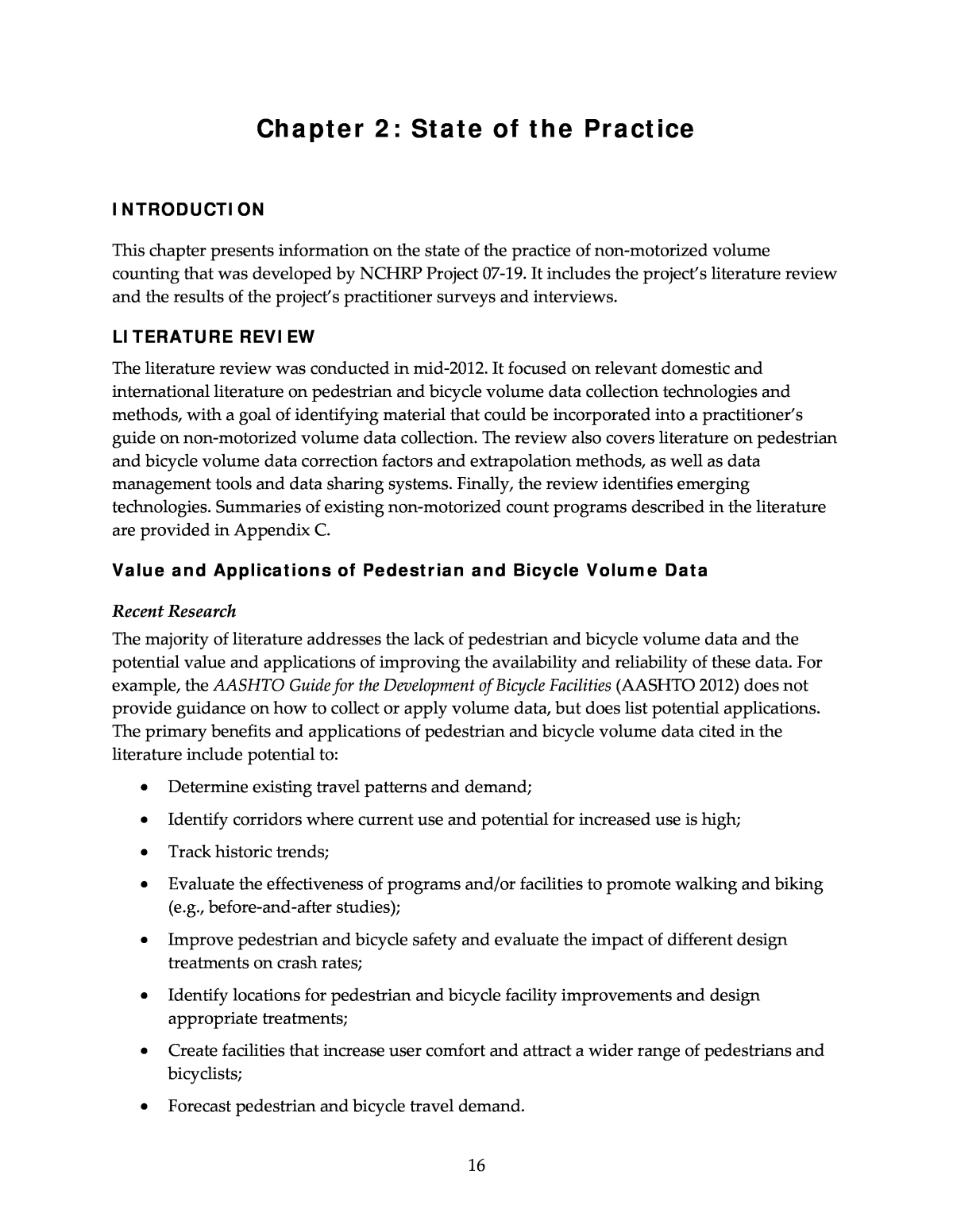
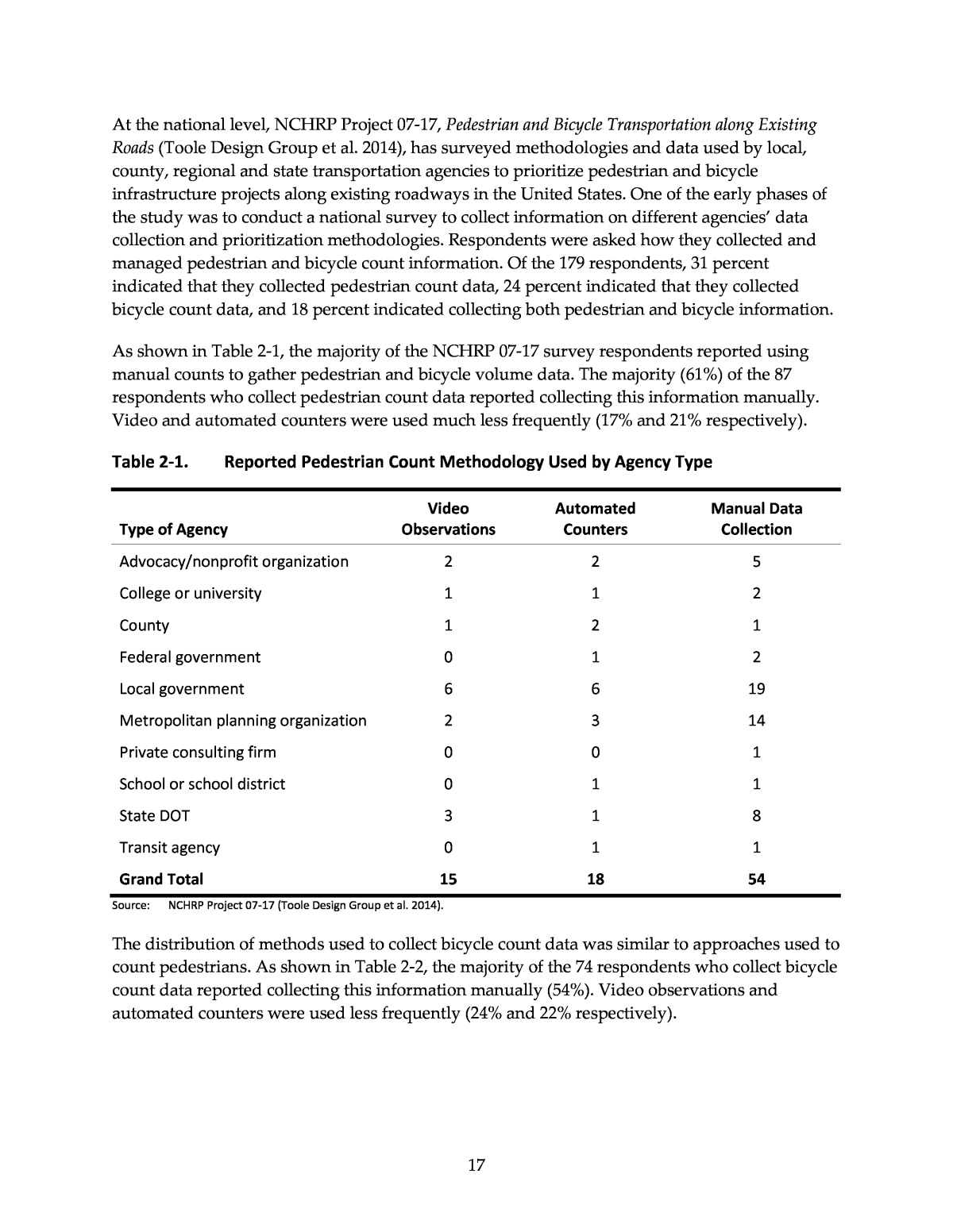
At the national level, NCHRP Project 07-17, Pedestrian and Bicycle Transportation along Existing Roads (Toole Design Group et al. 2014), has surveyed methodologies and data used by local, county, regional and state transportation agencies to prioritize pedestrian and bicycle infrastructure projects along existing roadways in the United States. One of the early phases of the study was to conduct a national survey to collect information on different agenciesâ data collection and prioritization methodologies. Respondents were asked how they collected and managed pedestrian and bicycle count information. Of the 179 respondents, 31 percent indicated that they collected pedestrian count data, 24 percent indicated that they collected bicycle count data, and 18 percent indicated collecting both pedestrian and bicycle information. As shown in Table 2-1, the majority of the NCHRP 07-17 survey respondents reported using manual counts to gather pedestrian and bicycle volume data. The majority (61%) of the 87 respondents who collect pedestrian count data reported collecting this information manually. Video and automated counters were used much less frequently (17% and 21% respectively). Table 2-1. Reported Pedestrian Count Methodology Used by Agency Type Type of Agency Video Observations Automated Counters Manual Data Collection Advocacy/nonprofit organization 2 2 5 College or university 1 1 2 County 1 2 1 Federal government 0 1 2 Local government 6 6 19 Metropolitan planning organization 2 3 14 Private consulting firm 0 0 1 School or school district 0 1 1 State DOT 3 1 8 Transit agency 0 1 1 Grand Total 15 18 54 Source: NCHRP Project 07-17 (Toole Design Group et al. 2014). The distribution of methods used to collect bicycle count data was similar to approaches used to count pedestrians. As shown in Table 2-2, the majority of the 74 respondents who collect bicycle count data reported collecting this information manually (54%). Video observations and automated counters were used less frequently (24% and 22% respectively). 17
Table 2-2. Reported Bicycle Count Methodology Used by Agency Type Type of Agency Video Observations Automated Counters Manual Data Collection Advocacy/nonprofit organization 1 2 3 College or university 1 0 1 County 1 1 1 Federal government 0 0 1 Local government 10 10 16 Metropolitan planning organization 1 2 11 Private consulting firm 0 0 1 School or school district 0 0 1 State DOT 3 1 4 Transit agency 1 0 1 Grand Total 18 16 40 Source: NCHRP Project 07-17 (Toole Design Group et al. 2014). The survey did not delve into the reasons why agencies chose to conduct manual counts, but based on responses to other questions about their pedestrian and bicycle program, concerns about cost and lack of staff resources to dedicate to pedestrian and bicycle issues may play a role. The study underscores the fact that, while data collection has become more sophisticated as it pertains to technology, there is little consistency between agencies with regard to how data are applied to prioritization methodologies. The survey and follow-up interviews conducted for NCHRP 07-17 may serve as a resource to help researchers identify agencies that are collecting bicycle and pedestrian volume data, and develop a better understanding of how it is being applied (at least as it pertains to prioritization). Developing a Pedestrian and Bicycle Volume Data Collection Plan Recent Research Pedestrian and Bicycle Data Collection in US Communities This report (Schneider et al. 2005) describes methods used for collecting pedestrian and bicycle volume data and provides guidance on interpreting the results to help guide the long-term planning of pedestrian and bicycle infrastructure. The report also addresses the benefits and shortcomings of collecting data on travel behavior, and concludes that there is no single best method of collecting use or facility data. Rather, a variety of data collection approaches may be appropriate, based on the nature of local needs. The report also profiles different strategies to reduce the costs of collecting bicycle and pedestrian data, including using automated technologies and volunteer labor. Finally, the report emphasizes the importance on repeating 18
data collection over time to help benchmark progress in building a non-motorized transportation system. AASHTO Guide for the Development of Bicycle Facilities, 2012 Edition Section 2.6 of the AASHTO Guide for the Development of Bicycle Facilities, Fourth Edition (AASHTO 2012) discusses the importance of identifying high-use corridors and understanding usage patterns before installing counting equipment. It also notes the following important elements of a data collection program: ⢠Collecting baseline data; ⢠Conducting counts over multiple years and seasons to account for event-related and seasonal variations in volumes; ⢠Accounting for existing conditions (e.g., facility type and land use) and traffic patterns; and ⢠Analyzing safety and demographic trends along with volumes. National Bicycle & Pedestrian Documentation Project (NBPD) The NBPD is led by Alta Planning + Design in collaboration with the Institute of Transportation Engineers (ITE) Pedestrian and Bicycle Council. It was started in 2004 as a response to the lack of useful data available on walking and bicycling and is a first attempt to create a repository for pedestrian and bicycle count and survey data collected from multiple communities throughout the U.S. The NBPD provides the following resources for practitioners establishing a data collection program: ⢠Materials and directions to conduct counts and surveys in a consistent manner; ⢠Standard count dates and times; ⢠A location where this information can be sent; and ⢠A mechanism to make this information available to the public. Since its inception, the NBPD has developed a Program Description, Training Guidelines, and Count/Survey Forms. These items are available to the public and intended to establish a consistent method for collecting and reporting bicycling and walking data (Alta Planning + Design 2012a and 2012b, Jones 2009). The NBPD has proposed a methodology for conducting volume counts and developed bicycle and pedestrian count and survey forms. The NBPD envisions that participating agencies and organizations will use the forms and methodology provided to conduct annual counts and surveys during the National Documentation Days in the second week of September. Supplemental data may be collected during set dates in January, May, and July to provide seasonal data. 19
2013 FHWA Traffic Monitoring Guide (TMG) The TMG was developed by the Federal Highway Administration to provide guidance to states on collecting traffic-related data. While acknowledging the wide range of practices and systems currently in use, the TMG provides a basic structure for statewide traffic data collection programs and includes information on how data are to be organized and coded. The original version of the TMG did not address non-motorized travel. However, the 2013 version includes a new chapter that is devoted specifically to non-motorized traffic. âChapter 4.0: Traffic Monitoring for Non-Motorized Trafficâ (FHWA 2013) opens with a discussion of key differences between monitoring for motorized and non-motorized traffic, including: ⢠The data collection scale is smaller. The number of monitoring locations is smaller and includes limited location samples (which may not represent the area as a whole and may make biased conclusions about data). Many locations are chosen based on highest usage levels or strategic areas of facility improvement; site selection criteria are therefore needed. ⢠Higher usage levels on lower functional class roads is expectedâpeople feel more comfortable riding/walking at lower speeds/volume of traffic. ⢠Short counts are more common due to difficulties in automating of counting and differentiating sex, gender, and helmet use. TMG Chapter 4 also outlines the process for developing permanent and short-term non- motorized data collection programs, following the same steps outlined for motorized traffic in TMG Chapter 3: ⢠Review existing count program(s). Coordinate with local and regional agencies and other departments or organizations not related to transportation (e.g., parks and recreation, health departments, retail/business associations, bike/ped advocacy groups) to determine what data and equipment are available and what data needs are. The review should assess: o Overall program design: ï§ Monitoring locations: where and why chosen ï§ Equipment: availability and limitations, if any ï§ Existing data: who uses data for what purposes, additional data needs, if no data are available then who would use the data and for what purposes? o Traffic Patterns: If data are available, evaluate daily, weekly, and seasonal variations in counts and whether these patterns are similar at different locations. o Data Processing: Identify data format (structure, interval, metadata, reporting), quality control processes, adjustment procedures, and processes for dealing with missing data. 20
o Summary Statistics: Identify statistics that are currently computed and those that may be needed, such as Annual Average Daily Traffic, seasonal average daily traffic, average daily traffic by month and day of week, and peak hour volumes for peak seasons. ⢠Develop an inventory of available count locations and equipment. ⢠Determine traffic patterns to be monitored. Define what type of roads/facilities will be monitored (e.g., off-street paths, local streets, arterials, state roads). If existing data are available, determine the types of traffic patterns expected on the network (e.g., commuting, recreational, utilitarian, mixed trip). ⢠Establish seasonal pattern groups. Limited previous research indicates that non- motorized traffic patterns can be classified into the following categories (each with their own unique time-of-day and day-of-week patterns): o Commuter trips: highest peaks in the morning/evening and low traffic during midday; more traffic during weekdays than weekends; and month-of-year traffic patterns are consistent regardless of season or climate. o Recreation/Utilitarian: strong peak during the middle of the day, more traffic on the weekends than on weekdays varying by season, and strong peak during late spring and summer. o Mixed Trip: includes trips that are both for commuting and recreational/utilitarian. ⢠Determine the appropriate number of count locations. Since there is little information about spatial and temporal variations of non-motorized traffic, the number of count locations is usually based on what is feasible given existing traffic monitoring budgets. If budget is not an issue, three to five continuous count locations are recommended per distinct factor group as the project begins, but the number of permanent locations can change as more data is collected. As of the time of writing, there had been no definitive U.S. guidance on the required number of short-duration count locations, although NBPD recommends 1 count per 15,000 population. (Note that Scandinavian research summarized later does provide guidance on the number of count locations.) ⢠Select count locations. For permanent counters, the TMG recommends selecting locations that are representative of prevailing non-motorized traffic patterns to help create reliable adjustment factors. For short-term counts, the TMG recommends focusing on targeted locations where activity levels and professional interest are the highest to provide more efficient use of limited data collection resources (e.g., random samples are likely to result in many locations with little to no non-motorized use). The National Bicycle and Pedestrian Documentation (NBPD) recommends the following sites: o Bike/Ped activity corridors: ï§ Multi-use paths and parks â at major access points ï§ On-street bikeways â at locations with few alternative parallel routes 21
ï§ Downtown areas â locations near transit stops ï§ Shopping malls â location near entrance of mall and transit stop ï§ Employment areas â near main access road ï§ Residential areas â near higher density developments, parks and schools o Locations representing urban, suburban, and rural locations o Key corridors to gauge impacts of future improvements o Locations with existing and ongoing historical counts o Locations with gaps/pinch points for bikes/peds o Locations with high collision rates ⢠Select count location type. The intended use(s) of the non-motorized traffic data will dictate which types of counts are most appropriate: o Screenline (mid segment) counts are primarily used to identify general use trends for a whole segment. o Intersection counts are primarily used for safety and/or operational purposes. ⢠Determine duration of counts. Prevailing practice has been 2 consecutive hours on a single day, but is evolving to longer durations to account for variability. Factors to consider include: o Manual vs. automated collection. Suggested duration for automated technologies is 7 to 14 days. Manual counters should be given breaks every 2 hours. The NBPD recommends conducting 1- to 3-hour manual counts on sequential days. o Count magnitude and variability â Consider longer duration counts to determine variability throughout the day and week. o Weather â Seasonality and conditions affect traffic. Weather conditions should always be recorded (i.e., precipitation, temperature). o Month/season â Data collection months should represent average or typical use levels, generally the spring and fall. The NBPD recommends mid-May and mid- September. o Factor availability â Short term counts should be adjusted to represent an annualized estimate. ⢠Compute adjustment factors. Seasonal, monthly, day-of-week, and other adjustment factors should be computed following a similar process as traffic volumes. The TMG concludes by introducing data codes to document different aspects of pedestrian and bicycle data collection, including directional orientation, road classification, type of facility, and the approach and technology used to gather data. 22
Turner and Lasley As an extension to work on establishing data collection programs, Turner and Lasley (2013) recommend a procedure for evaluating the quality of data under pedestrian and bicycle volume collection efforts. This procedure emphasizes the importance of data quality assurance prior to data collection, such as data collector training and equipment testing. Six criteria are proposed for evaluating data quality: accuracy, validity, completeness, timeliness, coverage, and accessibility. Accuracy and validity are explored in greater detail, with significant implications for the evaluation of automated counting devices. These two concepts are defined by the authors as: âAccuracy: The measure or degree of agreement between a data value or set of values and a source assumed to be correct. Also, a qualitative assessment of freedom from error, with a high assessment corresponding to a small error. Validity: The degree to which data values satisfy acceptance requirements of the validation criteria or fall within the respective domain of acceptable values.â Controlled evaluations and field evaluation are mentioned as potential approaches for investigating data accuracy. Controlled evaluations are recommended for testing a variety of factors, including group spacing, pedestrian/bicyclist speed, distance between detector and subjects, equipment mounting height, as well as a number of other external factors. Field evaluation, by contrast, is better suited to testing devices under conditions common to the facility on which they are installed. For instance, counters installed along a single-file hiking trail donât need to be evaluated for accuracy under contrived situations such as large clusters of hikers, as these situations are not likely to occur normally. Danish Road Directorate The Danish Road Directorate has developed guidance for conducting manual and automated traffic counts, including counts of bicycle traffic (Vejdirektoratet 2004). At the time of writing, the vast majority of automatic bicycle counting in Denmark was performed using loop detectors. The main differences between motorized traffic counting and bicycle counting that the Road Directorate identifies are: ⢠Bicycle counts are subject to greater error than motorized vehicle counts. ⢠The best bicycle count results occur when the counts take place on cycle tracks or bicycle paths separated from motorized vehicle traffic. When loop detectors are placed close to motorized vehicle traffic, some cars and trucks may also be counted. ⢠Ideal conditions are needed to get good results when counting in cities. ⢠It is not recommended to use loop detectors to count bicycles when they operate in mixed traffic with other vehicles. According to the Road Directorate, pneumatic tubes are feasible to use for short-term automatic counts, but there was little Danish experience with them for bicycle counting at the time the guidance was written. Radar and video were also identified as potential counting methods, 23
when bicycles could be separated from other traffic, but there was no Danish experience with either method as of the time of writing (Vejdirektoratet 2004). The Road Directorate also notes that there can be considerable differences in bicycle volumes from one week to the next, both due to weather effects and the fact that bicycle volumes are often relatively small. As a result, longer count durations are required to get good results, compared to motorized vehicle counting. Short-term bicycle counts are not advised. Table 2-3 shows the uncertainty in the estimate of bicycle average annual daily traffic (AADT) based on the length of the count, in weeks. For example, with a one-week count in a week without holidays, the average daily bicycle volume will be within 34% of the AADT 95% of the time (Vejdirektoratet 2004). Table 2-3. Accuracy of AADT Estimation Based on Count Duration Count duration (weeks) All weeks Weeks without holidays 1 39% 34% 2 28% 24% 3 23% 20% 4 20% 17% 5 18% 15% 6 16% 14% 7 15% 13% 8 14% 12% Source: Danish Road Directorate (Vejdirektoratet 2004). Note: Percentages indicate the potential error in the AADT estimate at a 95-percent confidence level. Swedish National Road and Transport Research Institute Niska et al. (2012) recommend methods for cities to use to track the annual change in pedestrian and bicycle traffic within the city. They find that it is not possible to accurately estimate the year-to-year change in citywide bicycle traffic with the resources available to most cities (i.e., a limited number of count sites and short-duration counts), but that counts can be used to measure changes on specific streets or routes and to identify longer-term trends in citywide bicycle traffic. To get the most comparable year-to-year results, the authors recommend: ⢠Using a good spread of counting sites, both in terms of geographic distribution and total number of sites. ⢠Counting for 2â4 weeks, supplemented by at least one permanent counting station, during times of year with relatively stable weather and no vacation periods (e.g., May or September). ⢠Documenting the characteristics of each yearâs count, including the method used to select sites, the count duration, the weather, the measurement method, the method used 24
to process the counts (e.g., weather adjustments, method used to determine averages), and a description of each site. ⢠Randomly selecting sites each year, if resources permit. Niska et al. conducted bicycle counts over 2 years in two Swedish cities (Lund and Jönköping) using more than 200 short-term count locations and at least one permanent count location, supplemented with travel surveys. Table 2-4 shows the error in the estimate of year-to-year change in bicycle traffic based on the number of randomly selected count locations within each city used to estimate the change. Table 2-4. Error in Prediction of Year-to-Year Change in Bicycle Traffic Based on Number of Count Sites in Two Swedish Cities Number of Sites Lund Jönköping 5 ±36% ±39% 10 ±26% ±27% 15 ±21% ±22% 20 ±18% ±19% 30 ±15% ±16% 40 ±13% ±14% 50 ±11% ±12% 100 ±8% ±9% 200 ±6% ±6% Source: Niska et al. (2012). Sensing Technologies for Non-Motorized Counting This part of the literature review summarizes current and emerging sensing technologies that can be used to conduct pedestrian and bicycle counts. This section generally uses the term âtechnologyâ to refer to the type of sensor used to detect pedestrians or bicyclists; individual devices may vary in the types of technology that can be used to power the device and to store and transfer data. General Overviews of Technologies FHWA Traffic Monitoring Guide (TMG) Chapter 4, Bicycle and Pedestrian Monitoring, of the TMG (FHWA 2013) discusses the different available technologies and data collection methodologies for monitoring non-motorized traffic in the U.S. The chapter describes the challenges of tracking pedestrian and bicycling activity, including issues related to the ways bicyclists and pedestrians travel, such as diverging from specified routes and traveling in closely spaced groups. The chapter also provides an overview 25
of different data collection equipment, describing the technology used, equipment characteristics, preferential installation location, and important variables. The chapter notes that the NBPD offers guidance on collecting manual counts, as well as an overview of automatic count technologies. It recommends different automatic count technologies based on the count location and purpose (Alta Planning + Design 2012a). Outputs of the NBPD methodology have not been rigorously tested to date. A review of the literature reveals a range of counting technologies currently in use in the U.S., from simple manual counts with paper forms to sophisticated image sensing equipment supported by computer algorithms that identify and count pedestrians and bicyclists. General categories of technologies currently in use include: ⢠Manual counts: data collectors perform counts in the field, and record results with a writing implement and paper, automated count board, or smartphone application. ⢠Pneumatic tubes: two rubber tubes are stretched across the right-of-way, and record counts when vehicles pass over them. ⢠Piezoelectric strips: material that produces an electric signal when deformed is laid on or under the ground in two strips. ⢠Pressure/acoustic pads: pads are placed in or on the ground to detect bicycle or pedestrian activity by changes in weight and sound waves. ⢠Inductive loop detectors: wires are installed in or on top of pavement to detect bicycle activity through their disruption of an electromagnetic field. ⢠Active infrared: bicycles and pedestrians are detected when an infrared beam is broken. ⢠Passive infrared: identifies the heat differential of bicyclists or pedestrians when they pass through the detection area. ⢠Laser scanning: laser pulses are sent out in a range of directions, details of the surroundings, including pedestrians and bicyclists, are recorded based on reflected pulses. ⢠Radio waves: detect bicycles and pedestrians when a radio signal between a source and a receiver is broken. ⢠Video image processing: uses visual pattern recognition technology and computerized algorithms to detect bicyclists and pedestrians. ⢠Magnetometers: detect bicycle activity through changes in the normal magnetic field. ⢠Radar: emits radio wave pulses and counts bicyclists and pedestrians based on an analysis of reflected pulses. Swedish National Road and Transport Research Institute Niska et al. (2012) summarize the state of Swedish knowledge about the applicability of various technologies to bicycle counting, as shown in Table 2-5. 26
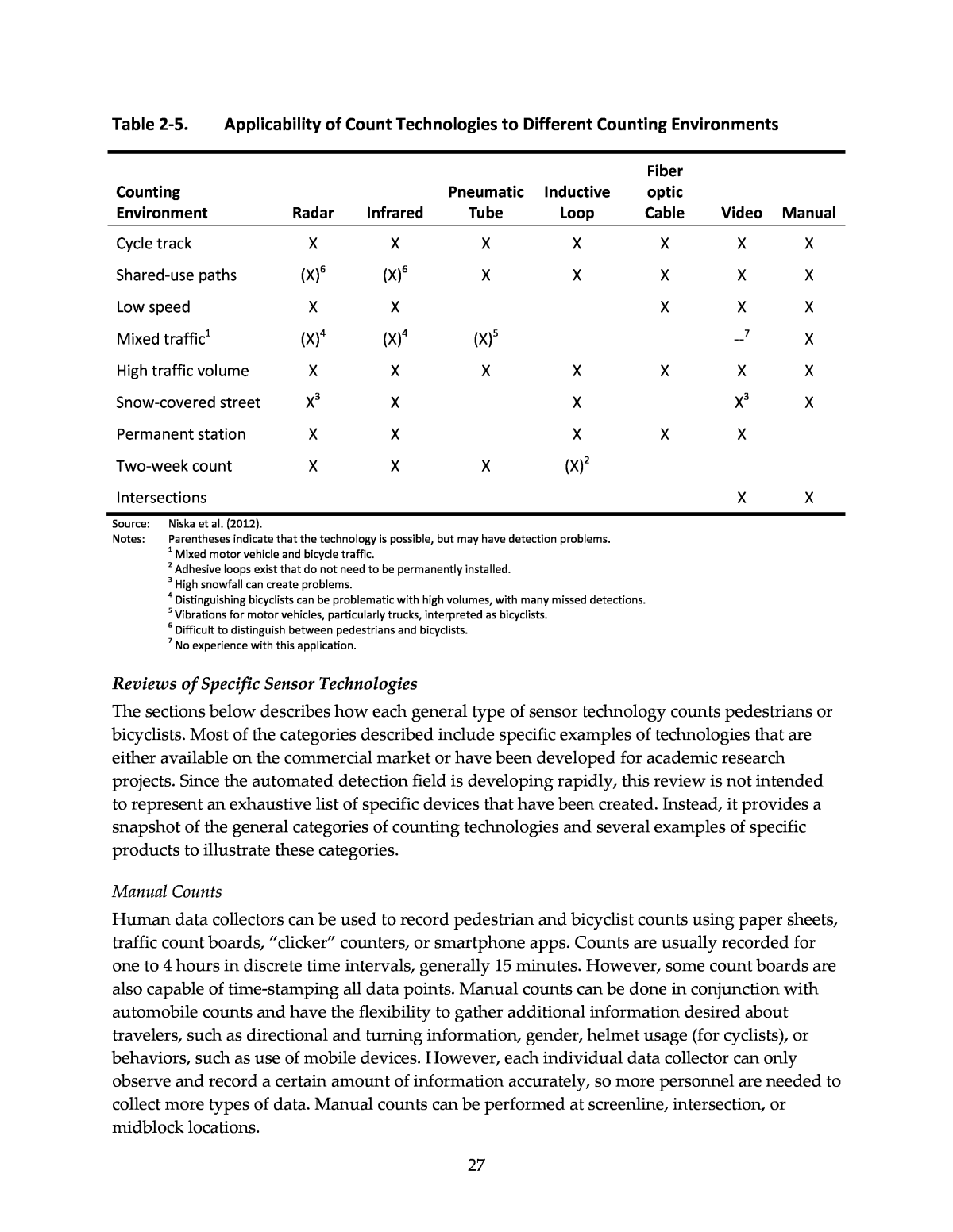
Table 2-5. Applicability of Count Technologies to Different Counting Environments Counting Environment Radar Infrared Pneumatic Tube Inductive Loop Fiber optic Cable Video Manual Cycle track X X X X X X X Shared-use paths (X)6 (X)6 X X X X X Low speed X X X X X Mixed traffic1 (X)4 (X)4 (X)5 --7 X High traffic volume X X X X X X X Snow-covered street X3 X X X3 X Permanent station X X X X X Two-week count X X X (X)2 Intersections X X Source: Niska et al. (2012). Notes: Parentheses indicate that the technology is possible, but may have detection problems. 1 Mixed motor vehicle and bicycle traffic. 2 Adhesive loops exist that do not need to be permanently installed. 3 High snowfall can create problems. 4 Distinguishing bicyclists can be problematic with high volumes, with many missed detections. 5 Vibrations for motor vehicles, particularly trucks, interpreted as bicyclists. 6 Difficult to distinguish between pedestrians and bicyclists. 7 No experience with this application. Reviews of Specific Sensor Technologies The sections below describes how each general type of sensor technology counts pedestrians or bicyclists. Most of the categories described include specific examples of technologies that are either available on the commercial market or have been developed for academic research projects. Since the automated detection field is developing rapidly, this review is not intended to represent an exhaustive list of specific devices that have been created. Instead, it provides a snapshot of the general categories of counting technologies and several examples of specific products to illustrate these categories. Manual Counts Human data collectors can be used to record pedestrian and bicyclist counts using paper sheets, traffic count boards, âclickerâ counters, or smartphone apps. Counts are usually recorded for one to 4 hours in discrete time intervals, generally 15 minutes. However, some count boards are also capable of time-stamping all data points. Manual counts can be done in conjunction with automobile counts and have the flexibility to gather additional information desired about travelers, such as directional and turning information, gender, helmet usage (for cyclists), or behaviors, such as use of mobile devices. However, each individual data collector can only observe and record a certain amount of information accurately, so more personnel are needed to collect more types of data. Manual counts can be performed at screenline, intersection, or midblock locations. 27
Many jurisdictions rely on manual counts taken on an annual basis at strategically chosen and distributed locations, either with the assistance of hired professional consultants or volunteers (Cottrell and Pal 2003). Care must be taken with volunteers to mitigate the effects of ulterior motives, in which the volunteer may discretionarily bias counts upwards or downwards. To reduce error, data collectors should be trained so they have a clear understanding of the count methodology. In addition, managers should plan data collection efforts carefully, ensuring that there are enough data collectors at high-volume locations so that each person can do their portion of the counts accurately. Diogenes et al. (2007) compared manual pedestrian counts at various intersections in San Francisco recorded using pencil and paper, clicker devices, and video. Video-based manual counts were taken to represent the ground truth. Both of the field counting methods exhibited systematic undercounting compared to the video counts (-8% to -25%), with higher rates of undercounting towards the beginning and end of the count periods. This study showed the importance of data collector training, motivation, and management for obtaining accurate manual counts. Greene-Roesel et al. (2008) found very little difference in counts obtained manually from video and in the field. In this study, in comparison to that by Diogenes et al. (2007), the counter was given a much simpler task in terms of data to collect while counting. This suggests that to obtain highly accurate data manually in the field, it is advisable to focus on counting all pedestrians, rather than noting characteristics about the pedestrians. Schneider, Arnold, and Ragland (2009) counted pedestrians for two-hour periods at 50 intersections in Alameda County, CA. The methodology specified that pedestrians should be counted each time they crossed a different leg of the intersection. To prevent confusion about whether or not to count people who stepped outside the crosswalk lines, pedestrians were counted whenever they crossed the roadway within 50 feet of the intersection. One to four data collectors were used, depending on the intersection volume (four data collectors were needed at an intersection with nearly 1,800 pedestrian crossings per hour). This study used paper forms. Schweizer (2005) reported being able to count roughly 2,000-4,000 pedestrians at an unspecified location using a clicker, but only half as many using pencil and paper. Appendix B of Jones et al. (2010) includes a thorough training guide for conducting manual counts. Pneumatic Tubes Pneumatic tubes are currently widely used to count automobiles, but they can also be used for bicycle counts. This technology is applied by stretching two rubber tubes across the right-of- way. When a bicycle or other vehicle passes over the tubes, pulses of air pass through to a detector which then deduces the vehicleâs axle spacing, and hence classifies it by vehicle type. This technology can be very effective when automatic data is needed for several days to several weeks. Pneumatic tubes have the benefits of being highly portable and easy to set up. Additionally, many jurisdictions are familiar with their operation from experience with automobile counts. However, pneumatic tubes suffer the consequences of being susceptible to theft, vandalism, and wear-and-tear. Additionally, care should be taken with the installation of 28
pneumatic tubes in locations where pedestrians and bicyclists share a right-of-way, as they can present a tripping hazard to pedestrians. Rubber tubes also do not maintain their properties in cold conditions and can deteriorate under high bicycle or vehicular traffic, thus reducing their accuracy. Travel direction can be detected through the use of two tubes (Alta Planning + Design 2011). ViaStrada (2009) performed a field test of bicycle counting using two pneumatic tube models in New Zealand. The tubes were installed in both off-road and on-road mixed traffic situations. Preliminary results presented in the report appeared promising in the off-road locations, but some installation difficulties pertaining to the width of the lane arose in the on-road locations. Accuracies reported for off-road locations were -11% (Error-Adjusted Index1=81%), -14.6% (EAI=82%), 0% (EAI=88%), and -1% (EAI=94%). Hjelkrem and Giæver (2009) tested two models of pneumatic tubes in mixed traffic and found bicycle count accuracy rates of -27.5% and -1.9%. Pneumatic tubes have also been discussed in previous literature reviews (AMEC E&I and Sprinkle Consulting 2011; Somasundaram, Morellas, and Papanikolopoulos 2010). Piezoelectric Strips Piezoelectric strips can be installed embedded within paved surfaces to count bicyclists. Piezoelectric materials emit an electric signal when they are physically deformed. Counters utilizing this technology consist of strips laid across the right-of-way that record and analyze electric signals produced similarly to pneumatic tubes. There is a current deficit of academic literature pertaining to piezoelectric strips for bicyclist counting. Schneider et al. (2005) discuss a case where the Iowa DOT used piezoelectric strip detectors to count bicyclists on multi-use paths. The Iowa DOT reported ease of use as a determining factor in selecting piezoelectric strips. As another example case, South East Queensland has developed a bicycle/pedestrian counting apparatus utilizing a commercially available piezoelectric strip system for bicycle counts and passive infrared for pedestrian counts (Davies 2008). Pressure/Acoustic Pads Pressure and acoustic pads are primarily used to count pedestrians on unpaved trails. These pads are installed in-ground, either flush with or under the surface. Installation can be difficult in paved situations, as the pavement must be cut. Counts are detected either by the change in weight on the pad (pressure) or by sound waves from footsteps (acoustic). One disadvantage of pads is that they depend on direct contact from pedestrians or bicyclists, and hence are primarily suited to channelized situations in which pedestrians or bicyclists are restricted to travel single file. Pads are also susceptible to problems when the ground freezes. No thorough tests of acoustic or pressure pads were found, but they are discussed in a number of literature reviews (Alta Planning + Design 2011; AMEC E&I and Sprinkle Consulting 2011; 1 Error-Adjusted Index is calculated as â ððð¡ð¡ ðð ð¡ð¡=1 âððð¡ð¡âððð¡ð¡ ððð¡ð¡ , where Mt is the manual count, Ot is the number of over-counts, and Ut is the number of under-counts. 29
Somasundaram, Morellas, and Papanikolopoulos 2010; Ozbay et al. 2010; Bu et al. 2007). This technology may be uncommon due to cost, lack of site flexibility (best for narrow walkways/trails), or other factors. Fiber-optic Pressure Sensors Fiber-optic pressure sensors detect changes in the amount of light transmitted through an imbedded fiber-optic cable based on the amount of pressure (weight) applied to the cable. The sensitivity of the counter can be adjusted based on the desired minimum or maximum weight to be counted. These sensors form the basis for some commercial âbicycle barometersâ in Europeâpermanent bicycle counting stations (Figure 2-1) that display to bicyclists and others how many bicyclists have passed by the location that day and/or year (Olsen Engineering 2012). (Bicycle barometers can also use other types of sensors, such as inductive loops.) Figure 2-1. Bicycle Barometers Source: Paul Ryus, Kittelson & Associates, Inc. Inductive Loop Detectors Inductive loop detectors consist of loops of wire with a current running through them. To count bicyclists, these devices are placed on top of the roadway or paved trail surface (temporary) or under the surface (embedded). Embedded loops must be installed by cutting the pavement surface. Bicycles are detected when they ride over the loops because they temporarily change the magnetic field produced by the current in the wires. Loop detectors must be placed in locations of low electromagnetic interference to work accurately. Loop detectors may overcount when bicyclists ride over certain points on the devices (they register two counts instead of one) and may undercount when multiple bicycles pass over the detector nearly simultaneously. Bicyclists moving at walking speed do not pose an accuracy problem for inductive loops designed to distinguish bicyclists (Nordback et al. 2011). 30
Nordback and Janson (2010) have tested traditional induction loops which do not distinguish between bicycles and other vehicles on off-road multiuse paths, and novel inductive loops capable of distinguishing bicycles from other vehicles on off-road paths and on shared roadways (Nordback et al. 2011) in Boulder, CO. The off-road counters (traditional induction loops) were found to have an average accuracy of -4% as compared with manual counts, with an average absolute value percent difference (AAPD)2 of 19%. The novel induction loops tested demonstrated -3% accuracy on separated paths (AAPD 8%) and +4% accuracy on shared roadways (AAPD 24%). ViaStrada (2009) tested two models of inductive loops in New Zealand at both on-road and multi-use trail sites. On-road sites had count accuracies of +2% (Error-Adjusted Index=88%), -10% (EAI=88.8%), +5% (EAI=90.2%), and +4% (EAI=75.7%). Off-road sites demonstrated accuracies of 0% (EAI=88%), -3% (EAI=87%), +25% (EAI=74%), and -10% (EAI=85%). Hjelkrem and Giæver (2009) tested four models of induction loops in Norway on sidewalks, mixed traffic roads, and bike lanes in uncontrolled traffic. In this study, the loops demonstrated accuracy rates of -16.5% to -2.5%. Sidewalk locations had the highest accuracy, with a range of -6.0% to -2.5%. No estimate of variance of errors was given. Active Infrared (Active IR) Active infrared sensors count pedestrians and bicyclists using an infrared beam between a source and a receiver. When the beam is broken by an object in its path, a count is recorded. These devices can record counts with ranges of about 30 meters between transmitter and receiver (Bu et al. 2007). However, they are incapable of distinguishing between objects breaking the beam. False positives can be recorded due to anything passing through the detection site, including vehicles, insects, leaves, animals, or rain drops. Further, false negatives can result from pedestrian occlusion. Jones et al. (2010) utilized a Trailmaster active infrared device in San Diego County, CA. After an initial validation count, it was determined that the device operated more accurately at a 45- degree angle relative to the direction of travel of pedestrians. Accuracy rates were found to be - 12% to -18% for all travelers, and -25% to -48% for pedestrians, with an inverse relationship between accuracy and flow. No estimates were made on variance of errors. Passive Infrared (Passive IR) Passive infrared sensors identify and count pedestrians and cyclists based on the infrared radiation (i.e., heat) that they emit. The placement of passive IR counters is critical to obtaining good results. Ideally, the device should be placed facing away from the street towards a fixed object (such as a wall) in a location where pedestrians are not likely to tend to linger (e.g., away from bus stops). Additionally, caution must be taken during installation to avoid problems with 2 Average Absolute Value Percent Difference is calculated as the sum of absolute differences between each automated count and its corresponding actual count divided by the total number of observations. 31
reflection due to water or windows and interference from power lines. Errors arise due to occlusion with groups of pedestrians. Passive infrared counters have been tested in a number of projects. Greene-Roesel et al. (2008) tested a passive IR counter at three sidewalk locations in Berkeley, CA. Automated counts were compared with video based manual counts, and were found to undercount at a fairly consistent rate (between -9% and -19% each hour). Schneider, Arnold, and Ragland (2009) also found relatively consistent rates of undercounting for sidewalk volumes of up to 400 to 500 pedestrians per hour at locations with different sidewalk widths and during sunny, cloudy, rainy, and dark conditions. However, Schneider et al. (2012) found that the rate of undercounting for passive IR counters increased as pedestrian volumes increased in San Francisco. The researchers hypothesized that there were more groups of pedestrians passing the counter side-by-side when pedestrian volumes increased, so occlusion rates increased. In order to correct for higher rates of undercounting at higher pedestrian volumes, Schneider et al. (2012) proposed a preliminary adjustment function for Eco-Counter passive infrared sensors, as seen in Figure 2-2. Undercounting is likely to depend on the width and design of the sidewalk in addition to the volume of pedestrians, so further research is needed to refine this adjustment function. Figure 2-2. Example Passive Infrared Sensor Adjustment Function Source: Schneider et al. (2012). Fifteen-minute manual validation counts were compared with automated counts at passive infrared sensor locations in Alameda County and San Francisco, CA (left graph in Figure 2-2). The locations had a variety of sidewalk widths and temperature conditions. Undercounting increased at higher volumes. Researchers used these counts to propose a preliminary automated counter adjustment function (right). Undercounting is likely to depend on the width and design of the sidewalk in addition to the volume of pedestrians. 0 100 200 300 400 500 600 700 800 0 100 200 300 400 500 600 700 800 M an ua l C ou nt (1 5- m in ut e pe rio d) Automated Count (15-minute period) Automated Counts vs. Manual Counts (15-minute periods) Manual = Automated Line y = 0.393x1.2672 0 100 200 300 400 500 600 700 800 0 100 200 300 400 500 600 700 800 M an ua l C ou nt (1 5- m in ut e pe rio d) Automated Count (15-minute period) Automated Count to Manual Count Conversion Function For Automated Counts > 49: Conversion Function Manual = Automated Line For Automated Counts < 49: y = 1.1x 32
Hudson, Qu, and Turner (2010) performed accuracy tests on a multi-use path in Texas using three different passive IR counters and one active IR counter. These counters were tested in a controlled manner for a variety of situations, including varied bicyclist speeds and pedestrian group spacing. Additionally, the devices were compared using a number of error metrics, including overall error, missed detection error, and false detection error. Overall, the Eco- Counter passive IR device proved to have lower error rates than the other three counters tested. This result may be due in part because this test occurred four years later than the other three, so the technology had more opportunity to mature. Jones et al. (2010) tested a passive IR counter (Jamar scanner) at various locations throughout San Diego County, CA. The device was found to have an accuracy of -15% to -21% relative to manual counts. It was also discovered that the device functioned more accurately when oriented at a 45-degree angle to the path of travel of pedestrians, rather than 90 degrees, to help avoid occlusion errors. Ozbay et al. (2010) tested an Eco-Counter pyroelectric sensor and a TrafSys thermal sensor on trails in Piscataway, NJ. This study reported mean absolute percentage errors of -28% to 0% for the Eco-Counter and -15% to 1% for the thermal sensor, with higher errors generally occurring at higher volume count locations. The study also includes detailed installation, calibration, and data retrieval notes. Montufar and Foord (2011) tested a variety of devices in cold weather, including an Xtralis ASIM IR 207 passive IR detector. The ASIM device showed very high levels of sensitivity regardless of temperature, but an increasing level of selectivity with increasing temperature. Hence, level of performance appears to decrease at lower temperatures for this device. Laser Scanning Laser scanners emit laser pulses in a range of directions and analyze the reflections of the pulses to determine characteristics of the deviceâs surroundings, including the presence of pedestrians or bicyclists. Two varieties of laser scanners exist: horizontal scanning and vertical scanning. Horizontal scanners require an open detection area with no obstructions. Vertical scanners must be mounted above the detection area. Laser scanners face operational difficulties in inclement weather, such as rain, snow, and fog, due to interference with the laser pulses (Bu et al. 2007). Laser scanning also entails heavy computational loads, so a dedicated CPU may be necessary to store and analyze the data. Numerous technical papers can be found on the topic of pedestrian tracking and counting using laser scanners (Musleh et al. 2010, Cui et al. 2007, Katabira et al. 2004, Shao et al. 2007, Navarro- Serment et al. 2008). Tanaka (2010) reports on the development and testing of a vertical laser scanner pedestrian counter. This device had an accuracy of greater than -5% error relative to manual counts. However, this system has not been tested in high pedestrian volume scenarios, which seem likely to introduce higher levels of error. Shao et al. (2011) developed a laser scanner mounted on a swinging arm to help solve difficulties of occlusion inherent to stationary laser scanner 33
counting. A reported difficulty in the study is that the scannerâs swinging frequency is insufficient to deal with highly crowded environments, so the authors propose combining this technology with an additional detector for high pedestrian densities. Laser scanners have been applied more heavily to vehicle-mounted detection systems than to ground-based pedestrian counting. Radio Beams Radio beams count pedestrians in a similar manner as active infrared counters. However, instead of an infrared beam, a radio signal is utilized. This allows the source and receiver to be placed behind certain objects (e.g., wood) that do not interfere with the signal, hence decreasing the risk of theft or vandalism. Radio beam counters require single file pedestrian travel, and hence are best suited to low volume or constrained locations. Discussions of this technology are very limited in the literature, with a brief mention by Somasundaram, Morellas, and Papanikolopoulos (2010). In New Zealand, the Queenstown Lakes District Council is noted anecdotally as utilizing these counters on two multi-use paths, and reporting them as the best counting technology that they had found based on 20 years of experience (ViaStrada 2009). Video Video analysis involves counting pedestrians or bicyclists from images created by cameras. Video analysis requires mounting a camera overhead, so it is necessary to find a mounting point where installing the camera is permitted. There are two main types of video analysis: manual and automated. Manual video analysis entails recording video at a study location and an analyst performing manual counts on the footage. Manual video counts offer the ability to slow down and replay footage to increase accuracy in situations where distinguishing individuals might otherwise be difficult. However, manually analyzing one hour of video can take roughly three hours, leading to far higher labor costs than manual counts in the field (Diogenes et al. 2007). As a counterpoint, manual counts conducted using video have been found to be more cost effective than human surveys conducted in the field, with labor savings of roughly a factor of 2 (Manhard Consulting 2011). In this study, the greatest cost savings were seen at rural and/or remote sites, with light traffic and simple configurations. Automated video analysis is sometimes referred to as computer visioning or image processing. Rather than having a technician view a video to perform counts, computer algorithms are used to identify when changes in the background image are actually pedestrians passing through the detection area. This process allows pedestrians to be counted automatically. Automated counting cameras are under development and have been used in several academic studies (Ismail et al. 2009; Malinovskiy, Zheng, and Wang 2009; Ribnick, Joshi, and Papanikolopoulus 2008; Li et al. 2012; Hu, Bouma, and Worring 2012). Similarly, Nguyen et al. (2012) propose a system to count pedestrians based on tracking. However, current technology has difficulties identifying and counting individual pedestrians traveling in groups. Reliable systems exist for indoor counting applications, but varying light intensities and other environmental factors make automated video counting substantially more difficult in outdoor settings. Somasundaram, Morellas, and Papanikolopoulus (2010) have developed an algorithm to separately identify bicyclists and pedestrians in video footage, reported to work at roughly 70% 34
accuracy. In a separate report from the same authors published two years later (Somasundaram, Morellas, and Papanikolopoulus 2012), the counting algorithmâs accuracy is reported to have been improved to 86% for bicyclist classification and 98% for pedestrian classification. Brändle, Belbachir, and Schraml (2010) have developed an overhead counting device for mixed cyclist and pedestrian flows known as SmartCountPlus. Based on an initial test of 128 passings with varied combinations of cyclists and pedestrians, the deviceâs accuracy has been reported at 92% for riding bicyclists and 100% for pedestrians. For mixtures of pedestrians, riding cyclists, walking cyclists, and pedestrians with umbrellas, accuracies are reported at 43% to 96%. Ling et al. (2010) have developed a system utilizing both a stereo camera and a laser scanner. The authors report an accuracy of over 90% in a realistic environment, including dense groups of pedestrians, but also state plans to further develop the technology to higher levels of consistency. Prabhu (2011) finds that the Autoscope Solo Terra counts pedestrians with greater than 85% accuracy in multiple experiments. Additionally, this paper discusses and tests a novel system combining the Autoscope technology with lower cost algorithmic processing of recorded video for increased accuracy in high pedestrian volume situations. Malinovskiy et al. (2009) have developed a method for tracking and tracing pedestrians and bicyclists using ordinary video footage. This system counts based on traces, and has worked around some of the inaccuracies that arise due to occlusion. As of 2009, this technology was reported as operating at an average 92.7% accuracy, where accuracy is calculated as 100%â 100%Ã((Overcounts + missed counts)/manual counts). Thermal Imaging Cameras Thermal imaging cameras are a combination of passive infrared and video counting technologies. This is an emerging technology and is therefore not documented in the literature. Magnetometers Magnetometers are currently widely used for detecting motor vehicles. Counts occur when ferrous (i.e., magnetic) objects enter the region above the device and alter the Earthâs magnetic field. No field tests have been found using these devices. The TMG (FHWA 2013) suggests that magnetometers might not perform well for bicycle counting in mixed traffic with motor vehicles. A manufacturer claims that magnetometers are best suited to ârural, rugged, and remoteâ applications for mountain bike counting (TRAFx 2012). Reasons cited for this include the device being easier to bury and hide than other bicycle counters, and its high sensitivity to ferrous objects. Radar Tests of bicycle and pedestrian counters using Doppler radar technology have not been widely documented. These devices operate by emitting electromagnetic pulses and deducing information about the surroundings based on the reflected pulses. Vienna, Austria reportedly utilizes radar-based counters and has found them to work âflawlessly,â as compared against 35
manual counts (AMEC E&I and Sprinkle Consulting 2011). However, no academic literature was found to support this claim. Paired Devices In order to count both bicyclists and pedestrians at a location with mixed traffic, technologies can be paired. The specific technologies being paired depends on the location under study, but the technique entails utilizing one device that counts all passers-by (e.g., passive infrared), and one device that exclusively counts bicyclists (e.g., inductive loops). Pedestrian volumes can then be calculated by subtracting the number of bicyclists from the total traveler volume. This technique is necessary in mixed-traffic situations because no current technologies are capable of accurately isolating and counting pedestrians. Sampling Data Collection Techniques A number of other technologies and techniques are available for gathering pedestrian and bicycle sample data, but have not been successfully used for estimating total pedestrian and bicycle volumes. These approaches are better suited to developing origin-destination travel patterns, investigating route choice, and developing system-wide mode share estimates. Bluetooth detectors, GPS data collection, pedestrian signal actuation buttons, radio-frequency (RF) tags, surveys, and transit vehicle automatic passenger counters have all been used to gather sample data and establish minimum pedestrian and bicycle volumes on various facilities. However, it is not possible to reliably convert this sample data to total counts due to the influence of multiple location-specific factors (e.g., smart phone usage, transit mode share). A brief description of these techniques and their limitations is presented below. ⢠Bluetooth Signal Detection. Consumer electronics enabled with Bluetooth wireless capabilities have proliferated across the market in recent years. Bluetooth readers record the unique ID of Bluetooth-enabled devices passing near a detector, generating a sample count of facility users. In order to be detected by a Bluetooth reader, a pedestrian or bicyclist must have a Bluetooth-enabled phone or other device with the Bluetooth transmitter turned on. By setting up multiple detectors around an area and matching unique device IDs, Bluetooth readers can be used to evaluate travel times and route choice. It is not possible to differentiate between modes using Bluetooth data, therefore application of this technology to pedestrian and bicycle studies is limited to isolated non-motorized environments, such as trails, malls, and stadiums (Liebig and Wagoum 2012). Estimating total pedestrian or bicycle volumes based on sample data is problematic even in these isolated locations, due to the need for location-specific adjustment factors based on the percentage of users with Bluetooth-enabled devices, percentage of users with multiple Bluetooth-enabled devices (e.g., cell phone and earpiece), ratio of devices with transmitters turned on, etc. ⢠GPS Data Collection. Multiple agencies have used stand-alone GPS units or smartphone applications (e.g., Cycle Tracks) that utilize the phonesâ GPS functionality to collect non-motorized trip data (Hood, Sall, and Charlton 2011). These applications have been used primarily to evaluate route choice, but have also been used to compare demand at different locations. The sample data collected through this method can be 36
used to establish minimum volumes at a location, but cannot be adjusted to estimate total pedestrian or bicycle volumes. Sample bias is also an issue with these technologies, as those being counted have to, at a minimum, opt-in to the program andâfor example, with smartphone appsâhave to remember to use the counting device on each trip. ⢠Pedestrian Signal Actuator Buttons. Day, Premachandra, and Bullock (2011) found that for their particular test site, signal activation rates were a reasonable proxy for relative rates of pedestrian demand. However, they explicitly state that observing these rates is not an effective method for collecting total pedestrian counts. Portland currently counts and stores pedestrian button activations at 14 locations, with more locations planned, and is investigating the possibility of developing relationships between actuations and demand, based on site characteristics (Kothuri et al. 2012). ⢠Surveys. Surveys can be used to collect other pedestrian and bicyclist data, such as mode share and origin-destination information. Mode shares can then be extrapolated to determine total pedestrian volumes for a larger area, such as within a traffic analysis zone (TAZ), but estimates made in this manner do not serve as a suitable means of collecting count data due to the relatively small sample size in contrast with a relatively large sample area with complex land use patterns. ⢠Transit Vehicle Automatic Passenger Counters (APCs). APCs record the number of passengers boarding and alighting a transit vehicle, typically based on farebox data and infrared sensors located at the vehicle doorways. APC data can be combined with GPS data gathered be the transit vehicleâs automatic vehicle locator (AVL) system to approximate the level of pedestrian activity at stop locations. APC data can be used in determining pedestrian waiting area space requirements for boarding passengers at the bus stop and in estimating cross-flow volumes for alighting passengers, which can influence pedestrian flow on sidewalks at busy bus stops. This method does not account for other pedestrian activity in an area, however, and cannot be used to estimate total pedestrian counts. ⢠Radio Frequency Identification (RFID) Tags. RFID tags are commonly used in the logistics industry for tracking individual packages, containers, etc. They can be read at a distance of 5â10 meters, depending on the antenna power and particular radio frequency used (Andersen 2011). Fredericia, Denmark has implemented a âCycle Scoreâ program that tracks how often participants visit specific sites (typically schools and worksites). Program participation is voluntary, but participation is encouraged through prize drawings (each check-in counts as an entry) and a website (www.cykelscore.dk) that provides rankings in various categories (most check-ins, most recent check-in, etc.). Participants in the program affix a laminated RFID tag to their front wheel. A box containing a tag reader, RFID antenna, power supply, and WiFi antenna is placed at each check-in location and forwards each check-in over the Internet to the cityâs bicycle program. Because affixing an RFID tag to oneâs bike is voluntary, this method only collects sample counts that may or may not be representative of the entire population. 37
Correction Factors and Extrapolation Methods An important distinction is made in this project between the concepts of correction factors and extrapolation methods. Both approaches adjust raw data. However, they are differentiated as follows: ⢠Correction factors (functions) are used to eliminate systematic inaccuracies (e.g., over- or undercounting) in pedestrian or bicycle counts that result from the data collection technology used. Strictly speaking, a correction factor involves a simple multiplicative adjustment, while a function involves a more involved series of calculations; however, this report generally uses the term âfactorâ to cover both types of calculation. ⢠Extrapolation methods are used to expand short-duration counts to estimate volumes over longer time periods or to compare counts taken under different conditions. Correction factors have been developed for a few pedestrian and bicycle counting technologies based on the accuracy studies described in the proceeding section. These correction factors may not be straightforward, linear, or necessarily similar to motor vehicle counter correction factors. Certain sensor technologies may over- or undercount by different amounts under different conditions, so different correction factors may be needed for the same type of technology in different situations. Most pedestrian and bicycle counting technologies have not been tested rigorously for accuracy, so variable correction factors are rare. The remainder of this section summarizes extrapolation methods used in pedestrian and bicycle travel monitoring. More extensive information on these topics is provided in the TMG (FHWA 2013). Extrapolation methods address common challenges faced when converting raw pedestrian or bicycle count data into useful information for technical analysis and public presentation. These factors can be applied as follows: ⢠Temporal adjustment factors extrapolate counts taken during a short time period to estimate the volume of pedestrians or bicyclists at the count location over a longer time period. They are also applied to compare counts that have been taken at different times of the day, week, or year. ⢠Land use adjustment factors control for different types of pedestrian and bicycle activity patterns near specific land uses. ⢠Weather adjustment factors account for the effect of weather conditions on pedestrian or bicycle activity. ⢠Access/infrastructure sufficiency adjustment factors account for the effect of pedestrian/bicycle access, facility type, and network development on pedestrian or bicycle activity patterns. ⢠Demographic adjustment factors control for surrounding area demographics. The extrapolation process uses assumptions about long-term patterns of pedestrian or bicycle activity to estimate daily, weekly, or annual pedestrian or bicycle volumes from a short- 38
duration (e.g., two-hour) count. Extrapolation is useful because resource limitations may prevent agencies or researchers from collecting data over an extended period of time at all locations where volumes are desired. Extrapolated data have been used to: ⢠Estimate pedestrian and bicycle exposure for safety analyses (i.e., express pedestrian or bicycle risk as the rate of reported pedestrian crashes per user). Crashes are often reported over long time periods (e.g., one year), so a parallel measure of exposure is needed. ⢠Compare long-term pedestrian and bicycle volumes between locations where short- duration counts were taken at different points in time. ⢠Estimate daily or annual pedestrian or bicycle volumes for comparison to nearby automobile volumes. Extrapolation methods are based on two types of data: (a) pedestrian and bicycle activity patterns (often generated by automated counting technologies) and (b) short-duration counts (typically collected manually). The overall accuracy of extrapolated pedestrian or bicycle volume estimates depends on the accuracy of the overall activity pattern data and the short- duration count data. Therefore, temporal, land use, and weather adjustment factors have been developed to increase the accuracy of these inputs. Recent Research A summary of research on non-motorized volume adjustment factors and extrapolation methods is given in Table 2-6. Current Factors in Use This section summarizes the types of factors for adjusting and extrapolating counts currently in use, based on available literature and case studies. Temporal Adjustment Factors Temporal adjustment factors are used to account for âpeakingâ patterns, or the tendency for pedestrian or bicycle volumes to be distributed unevenly throughout the day, week, or year. For example, there may be high pedestrian volumes on sidewalks in a central business district at 5 p.m., but relatively low volumes at 3 a.m. A popular recreational trail may have higher bicycle volumes on weekends than weekdays. The most basic form of extrapolation is to multiply a short-duration count by the inverse of its proportion of the longer time period to estimate the volume during the longer time period. For example, if each hour of the day had exactly the same number of pedestrians or bicyclists at a particular location, each hour would represent approximately 4.2% (1 hour/24 hours) of the daily volume. In this case, it would be possible to multiply the one-hour volume by 24 to estimate the daily volume. However, pedestrian and bicycle volumes are rarely constant over long periods of time. Several studies have developed temporal adjustments to more accurately reflect uneven distributions of pedestrian and bicycle activity. 39
Greene-Roesel et al. (2008) describes a method for establishing adjustment factors for automated counts on pages 65â81. A step-by-step approach is given for stratifying a region into similar location types, and determining temporal adjustment factors for these different location types. This method also provides a way to estimate the error of the adjusted volumes. Davis, King, and Robertson (1988) investigated the predictive power of taking 5-minute sample counts at various points in an analysis period. Counts taken at the middle of the interval were the most predictive (over the beginning, end, or a random point in the interval), and accuracy was improved as sample times were increased from 5 to 30 minutes. Further, accuracy decreased with increasing length of prediction. Expansion models are given for 5, 10, 15, and 30 minute counts to predict 1, 2, 3, and 4 hour volumes. Hocherman, Hakkert, and Bar-Ziv (1988) note that, in Israel, very little pedestrian traffic occurs between the hours of 2200 and 0700. In residential areas, the flow during this nighttime period is 3% ADT, and in CBDs is 7% ADT. Accordingly, they assert that one can get simply take 15- hour daytime counts (from 0700â2200) and multiply these volumes by the appropriate factor (1.03 or 1.07) to calculate 24-hour ADT. Cameron (1977) demonstrated month-to-month variations in pedestrian activity at shopper locations in Seattle, with peaks occurring in August and December likely due to back-to-school and Christmas shopping, respectively. At the same locations, day-to-day peaks were observed on Fridays and Saturdays, with Fridays having pedestrian rates 24% above ADT. Hourly comparisons showed that the noon hour accounted for 14% of the average weekday total. On Saturdays, a peak was observed from 2 p.m. to 3 p.m. with gradual increases and decreases in traffic prior to and after the peak. At employee-dominated locations, Fridays had roughly 1/3 more traffic than ADT, while Saturdays averaged about ½ ADT. Sundays had the lowest traffic. Noon peaks at these locations made up roughly 13.5%â18.5% of the total daily pedestrian volume. At visitor locations, weekday peaks occur between 1 and 2 p.m., with 11.2% traffic. Saturdays have a high activity period from 1 to 4 p.m. with no distinct peak, and Sundays have high activity from 1 to 6 p.m. with a peak from 3 to 4 p.m. Hocherman, Hakkert, and Bar-Ziv (1988) observed three distinct daily pedestrian volume peaks in residential areas and CBDs in Israel. In the residential areas, the peaks and hourly percentages of ADT were as follows: 7 to 8 a.m. (13.6%), 12 to 1 p.m. (8.6%), and 4 to 7 p.m. (7.6%â9.9%). In the CBDs, the peaks were similar: 7 to 8 a.m. (7.1%), 11 a.m. to 1 p.m. (8.8%â 9.1%), and 4 to 7 p.m. (8.8%). They point to particular sociocultural reasons why the peaks are different in these two regions, namely the locations and start times of schools and the time that most stores open. Further, there was little seasonal variation in Israel, aside from during school vacations and on weekends. 40
Table 2-6. Summary of Research on Pedestrian and Bicycle Volume Patterns Author(s), Year Summary Temporal Factors Weather Factors Land Use/Demographic Factors Cameron, 1977 Automated ped counts in Seattle, WA Observation of hourly and daily fluctuations Decreased shopper volumes due to rain Distinct patterns observed for separate pedestrian classes: shoppers, commuters, visitors, and mixed Davis, King, and Robertson 1988 18,000 5-minute counts in Washington D.C. ⢠Middle of a count interval produces more accurate model. ⢠Longer count intervals also produce more accurate models. N/A Six distinct volume patterns based on land use appeared across 14 sites Hocherman, Hakkert, and Bar- Ziv 1988 84 count locations in Israel, with 135 daily counts in 15- minute intervals recorded Three peaks observed in both CBD (0700-0800; 1200-1300; 1600-1900) and residential areas (0700-0800; 1100-1300; 1600-1900) N/A Different patterns observed in the CBD and residential areas Lindsey and Nguyen 2004 Automated counts of pedestrians and bicyclists taken on multiuse trails in Indiana at locations on 6 different trails as well as at 5 locations along one trail Higher traffic on weekends than weekdays (average 31% higher in September, 61% in October). Weekday peaks observed in late afternoon/early evening. Weekend peaks observed in mid-late afternoon. Trail volume varied by population of city Zegeer et al. 2005 Calculations of ADT explained in Appendix A. Adjustment factors from 8- to 12- hour counts at 22 intersections, and from 24- hour counts in Seattle, WA Distinct flow patterns observed in three land use types, although all three are characterized by a midday peak N/A Different temporal patterns used in CBD, fringe, and residential areas Lindsey et al. 2007 Long-term automated (active IR) counts on greenways in Indianapolis, IN July and August represent monthly peaks; 60% higher volume on weekends than weekdays Phung and Rose 2007 Analysis of permanent inductive loop data from off- road paths in Melbourne, Australia Identify commuter routes vs. recreational routes based on whether highest usage occurs on weekdays or weekends/holidays ⢠8-19% reduction in bicycle volume with light rain (0.2â10 mm/day) ⢠13-25% reduction in bicycle volume with heavy rain (10+ mm/day) ⢠Only heavy wind (>40 km/h, based on average of 9 am and 3 pm observations) had a statistically significant effect on volumes ⢠Bay Trail (recreational use, more exposed?) was much more impacted by weather than other facilities, with a 48% volume reduction with a combination of light rain and strong winds. 41
Author(s), Year Summary Temporal Factors Weather Factors Land Use/Demographic Factors Aultman-Hall, Lane, and Lambert 2009 One year of automated pedestrian count data (pyroelectric) from Montpelier, VT Single midday peak observed, presumably location-specific 13% decrease in volume during precipitation events N/A Schneider, Arnold, and Ragland 2009 Method to expand from 2- hour counts to weekly pedestrian volumes. Tested in Alameda County, CA Weekly patterns averaged across days and locations presented graphically ⢠Rain reduces pedestrian volume by 35%- 65%, larger effect on weekends ⢠Cloud cover reduces volumes by 5%-24% ⢠Warmer air temperatures associated with lower volumes, although very few extreme temperature events observed Adjustment factors found for employment centers, residential areas, neighborhood commercial districts, and locations near multiuse trails Miranda-Moreno and Nosal 2011 Three cycling seasons of automated bicycle counts(induction loop) from 5 counters in Montreal, QC, Canada analyzed for a range of factors ⢠AM/PM peaks demonstrated ⢠Day-of-week effect appears to peak mid-week, with slight decreases on M/F and large decreases on Sa/Su ⢠Monthly effects appear to peak in summer with increases in Spring and decreases in Fall. Temperature, humidity, and precipitation all have significant effects, with variations across facilities and temporal variables. Lagged precipitation effect (rain in previous 3 hours or morning) demonstrated. Effects of temperature deviations from the average vary by season. Bike facility installation appears to have increasing cycling levels. Flynn et al. 2012 Longitudinal study on effects of weather on 163 frequent bicycle commutersâ decisions to bicycle Precipitation, temperature, wind, and snow all found to statistically significantly affect ridership likelihood, to varying degrees. 42
Author(s), Year Summary Temporal Factors Weather Factors Land Use/Demographic Factors Chapman Lahti and Miranda-Moreno 2012 One year of automated pedestrian counts (pyroelectric) from 5 counters in Montreal analyzed for a range of factors, controlling for seasons Temperate months: ⢠Flows increase with temperature, then decrease above 25ËC. ⢠Lagged precipitation effect (1 hour) confirmed. ⢠Precipitation effects - roughly linear. Winter months: ⢠Flows linear w/ temperature on weekends, stabilize to a minimum level for decreasing temperatures on weekdays. ⢠Humidity effects 3X greater on weekends. ⢠Precipitation patterns similar to temperature patterns. ⢠Lagged precipitation reduced flows by 14% on weekdays, insignificant on weekends. Weekdays: Mixed commercial-residential areas had 70% less activity than highly commercial areas. Weekends: Same comparison lower by 57% in warm months and 40% in winter. Milligan, Poapst, and Montufar 2012 Comparison of extrapolations from 2-hr counts to longer period volumes using 3 methods, along with ground truth data, in Winnipeg, Manitoba Locally developed vehicle volume expansion factors better predictors than nationally developed pedestrian volume expansion factors. Hankey et al., 2012 Volume models developed based on bicycle and pedestrian counts along both on- and off-road bicycle and pedestrian facilities Scaling factors developed based on time of day for expansion to 12-hour volumes. Precipitation included as a variable in all models. Comparisons between facility types. Regression volume models include race, education, income, crime, built environment, and facility-type variables. Nordback 2012 Dissertation on predicting bicyclist volumes, including factoring techniques, with counts performed in Colorado Investigated temporal factors using a factoring method and a statistical modeling method; found statistical modeling to be more predictive Temperature found to be the greatest predictor, with quadratic and cubic forms, followed by hourly solar radiation, daily high temperature, daily low temperature, snow, and precipitation. 43
Lindsey and Nguyen (2004) studied trail user volumes on six urban multiuse greenway trails in Indiana, including five count locations along one trail through Indianapolis. Twenty-four-hour volumes were collected using active infrared counters (TRAILMASTER 1500), and corrected using a linear adjustment function, based on 56 hours of field counts. Weekend average daily volumes were found to be on 36% higher than daily weekday volumes during September, and 61% higher during October. Peak hour factors3 (PHFs) were generated for all sites on a monthly basis. In September, the weekday PHFs across all trails ranged from 1.5 to 2.5 and weekend PHFs ranged from 1.3 to 1.7. Similarly, in October, the values ranged from 1.5 to 2.7 on weekdays and from 1.6 to 2.1 on weekends. The overall lower values on weekends suggested that weekday peaking is a stronger effect for the locations under study. In a follow-up study, Lindsey et al. (2007) performed continuous counts at 30 sites across a network of 5 greenway trails in Indianapolis using active infrared counters over periods of 1â4 years. July and August had the highest average monthly volumes. Weekend daily traffic was on average roughly 60% greater than weekday daily traffic. Hourly patterns varied between weekends and weekdays, as well as across locations. Aultman-Hall, Lane, and Lambert (2009) found a distinct hourly pedestrian volume profile based on year-long counts at a site in downtown Montpelier, VT. A single midday peak was observed, which the authors attribute to site-specific causes. A 16% decrease in pedestrian volumes was also observed during the winter months. Schneider et al. (2009) counted pedestrians automatically at 11 count locations throughout Alameda County, CA. Particular adjustment factors based on time of day were not given, but results for percent of weekly volume by hour of week were shown in a graphical format in Figure 2-3. This paper suggested that this approach can be repeated by conducting automated counts to determine the percentage share that a particular hour of the week accounts for, and using this factor to estimate weekly volumes. 3 Calculated as the ratio of mean peak hour traffic to mean hourly traffic. 44
Figure 2-3. Typical Alameda County Weekly Pedestrian Volume Pattern Source: Schneider et al. (2009). Note: This weekly pedestrian volume pattern is based on average hourly counts collected at 13 automated counter locations in Alameda County, CA. The hourly counts were collected for approximately four months at each location (one month each quarter) between April 2008 and April 2009. Jones et al. (2010) developed monthly adjustment factors based on automated counts obtained on multiuse paths and sidewalks in San Diego County, CA. These factors are presented in Table 2-7. The same study also determined day-of-week and time-of-day percentages, as shown in Tables 2-8 and 2-9. Table 2-7. Daily Activity Share by Day of Week Day San Diego Average % Monday 12 Tuesday 12 Wednesday 11 Thursday 11 Friday 14 Saturday 21 Sunday 19 Source: Jones et al. (2010). 0.00% 0.20% 0.40% 0.60% 0.80% 1.00% 1.20% 1.40% 12 A M 4 AM 8 AM 12 P M 4 PM 8 PM 12 A M 4 AM 8 AM 12 P M 4 PM 8 PM 12 A M 4 AM 8 AM 12 P M 4 PM 8 PM 12 A M 4 AM 8 AM 12 P M 4 PM 8 PM 12 A M 4 AM 8 AM 12 P M 4 PM 8 PM 12 A M 4 AM 8 AM 12 P M 4 PM 8 PM 12 A M 4 AM 8 AM 12 P M 4 PM 8 PM Pe rc en t o f W ee kl y Pe de st ria n Vo lu m e pe r H ou r M T W Th F Sa Su 45
Table 2-8. Monthly Expansion Factors on Multi-Use Paths and Sidewalks in San Diego County, CA Month Multi-Use Paths All Other January 1.0 1.0 February 0.89 0.89 March 0.5 0.5 April 1.0 1.0 May 1.0 1.0 June 1.0 1.0 July 0.57 1.0 August 0.89 1.0 September 1.3 1.0 October 2.0 1.0 November 1.14 1.0 December 1.0 1.0 Source: Jones et al. (2010). Table 2-9. Hourly Share by Hour of Day Hour Starting San Diego Average % 8 a.m. 6 9 a.m. 8 10 a.m. 9 11 a.m. 9 12 p.m. 9 1 p.m. 8 2 p.m. 8 3 p.m. 8 4 p.m. 7 5 p.m. 7 6 p.m. 6 Source: Jones et al. (2010). Turner, Qu, and Lasley (2012) developed a plan for Colorado DOT to collect non-motorized volume data. This report included recommendations for extrapolating short counts to estimate volumes over longer time periods. Specifically, it recommended developing distinct factor groups based on volume pattern variations across time of day, day of week, and month of year. Based on data sampled from automated counters around the state, they found the following factor groups to be the most predictive: commuter and work/school-based trips, recreation/utilitarian, and mixed trip purposes. For each of these groups, a general description 46
of common peaking patterns was given for the three time regimes described above. Further, directions for short-duration counting site selection were proposed, generally based upon NBPD instructions. Miranda-Moreno and Nosal (2011) observed a double peaking pattern on bicycle facilities in Montreal, Quebec. The a.m. peak occurs between 8 and 10 a.m., and the p.m. peak between 4 and 6 p.m. A slight midweek rise in volumes appeared (e.g., highest volumes on Tuesday through Thursday), with significantly lower volumes on weekends. This pattern confirms the authorsâ suspicions that these facilities are primarily utilitarian. Weekend daily volumes were found to be 65% to 89% lower than Monday volumes, the least ridden weekday. Ridership peaked in the summer months, with gradual increases and decreases in the months before and after. Summer volumes were observed to be 32% to 39% greater than in April. Additionally, no data was taken from December through March, as Montrealâs bicycle facilities are closed during these months. Finally, use of these particular bicycle facilities appeared to be on the rise in Montreal, with 20â27% and 35â40% increases respectively in 2009 and 2010, compared to 2008. Chapman Lahti and Miranda-Moreno (2012) compared temporal pedestrian volume patterns between the temperate months (April-November) and winter months (December-March) in Montreal. On weekdays, three distinct daily peaks were observed, as has been previously observed in a variety of locations. The a.m. and p.m. peaks were roughly the same in volume between seasons, but the midday peak had slightly lower volumes during the winter months, suggesting that these trips are optional for some pedestrians. Weekend volumes had a single mid-afternoon peak during both seasons, with gradual increases and decreases towards and away from the peak. Winter weekends had lower pedestrian volumes overall than temperate weekends. Milligan, Poapst, and Montufar (2012) compare estimates of pedestrian volumes based on 2- hour counts to a best-estimate of ground truth based on the NBPD methodology. They also compare the pedestrian volume patterns to the daily vehicular traffic patterns in the central business district (CBD) of Winnipeg, Manitoba. This study demonstrates that in the particular intersection under study, vehicle expansion factors serve as a better estimate for the ground truth than do NBPD expansion factors. The vehicular factors were developed for Winnipeg, whereas the NBPD factors are based on data from a variety of locations throughout the U.S.. Accordingly, it can be concluded that location-specific factors are important in developing temporal expansion factors. In addition to the above research, the TMG (FHWA 2013) includes guidance on how non- motorized volume data collection and reporting should account for time of day, day of the week and seasonal variability, and should account for any traffic patterns over time. Comprehensive information on this topic is limited, primarily because very few public agencies have collected and analyzed continuous non-motorized traffic data to date. The TMG relies on data collected from the Cherry Creek Trail in Denver to illustrate typical variations in pedestrian and bicycle volumes. 47
To account for daily, weekly, and seasonal variability, the TMG recommends non-motorized data collection programs include both continuously operating data collection sites to provide data on seasonal and day of week trends and short duration sites to account for specific geographic traffic patterns and time of day trends. The NBPD has also started to identify Count Adjustment Factors (Alta Planning + Design, 2012b) that can be used to adjust counts conducted during almost any period on multi-use paths and pedestrian districts to an annual figure. These factors adjust one-hour counts to annual totals by considering weekly, monthly, and trends in walking and bicycling rates. However, this technique may be inaccurate for specific local contexts. More year-long automatic count data are needed from different parts of the county to expand the application of the adjustment factors provided by NBPD to more facilities, areas, and time periods. Hankey et al. (2012) calculated scale factors based on 12-hour continuous counts along a variety of bicycle and pedestrian facilities in Minneapolis, MN. In theory, these factors can be applied to 1-hour counts performed in a given time period to determine 12-hour volumes. Nordback (2012) compared the predictive power of using a factoring method akin to that proposed by the NBPD against using a so-called âhybrid model.â While variations in accuracies exist based on the variable being considered, Nordback concludes that the statistical modeling approach generally provides higher accuracy estimates, but is more costly to use given the need for specialized modeling software and access to hourly weather data. The factoring method, by contrast, can provide low-cost estimates, albeit at a much lower level of accuracy. Land Use Adjustment Factors Land use adjustment factors account for variations in traveler volumes based on particular land uses in the vicinity of the counter. For example, the number of houses or jobs within a ¼ mile of the count location can have an effect on pedestrian volumes. Temporal extrapolation factors should be selected given the land use characteristics of the count location. For example, residential locations are less likely than CBDs to have midday pedestrian peaks. Cameron (1977) conducted automated pedestrian counts in various locations throughout downtown Seattle. Distinct trends were noted based upon the general character of the population being observed, separated into classes of shoppers, employees, visitors, commuters, and mixed. These classifications were made based upon the volume trends observed for each location. Shopper locations demonstrated peaks during the noon and 2 p.m. to 3 p.m. hours, on Fridays and Saturdays, during August and December, as well as surrounding major shopping holidays. Employee locations are characterized by peaks on Fridays, from 7 to 9 a.m., 12 to 1 p.m., and 4 to 6 p.m. Waterfront shopping locations, classified as visitor populations, demonstrate hourly weekday patterns similar to shopper and employee count sites with a midday peak but have distinct hourly weekend trends. Commuter locations demonstrate trends similar to vehicle trends. Mixed volume locations do not fit neatly into any of the other four classes identified, with no distinct noon peak. 48
Davis, King, and Robertson (1988) observed six distinct pedestrian volume trend patterns at various count locations in Washington D.C. No conclusions were drawn pertaining to land uses. Hocherman, Hakkert, and Bar-Ziv (1988) found similar daily peaking patterns in residential and CBD crossing locations, with slight differences. These differences were attributed to the location of schools exclusively in residential areas (hence a steeper early morning peak in these regions), and stores opening around 9 a.m. in CBDs (less steep of a morning peak in the CBD). Zegeer et al. (2005) utilized different adjustment factors based on location type, using classifications of CBD, fringe, and residential. CBDs are defined as downtown areas with moderate-high pedestrian volumes, fringe areas are suburban and commercial retail areas with moderate volumes, and residential areas are characterized by low pedestrian volumes. These hourly adjustment factor patterns were based upon two datasets of automated counts, one involving 8- to 12-hour counts at 11 marked and 11 unmarked intersections, and the other based on 24-hour counts in Seattle, WA. Schneider et al. (2009) explored land use characteristics of their count locations. Adjustment factors based on land use designations were derived for specific manual count intervals, and are summarized in Table 2-10. The manual count intervals are specified to control for temporal variations. The authors suggest that further research is necessary to account for additional land use factors not investigated in this study. Table 2-10. Land Use Adjustment Factors Source: Schneider et al. (2009). Land Use Category Definition of Land Use Manual Count Time Multiplicative Adjustment Factor Employment center ⥠2000 jobs within ¼ mi. Weekdays 12â2 p.m. 0.795 Residential area ⤠500 jobs within ¼ mi. and no commercial retail properties within 1/10 mi. Weekdays 12â2 p.m. 1.39 Neighborhood commercial area ⥠10 commercial retail properties within 1/10 mi. Saturday 12â2 p.m. 0.722 Saturday 3â5 p.m. 0.714 Near multi-use trail ⥠0.5 centerline miles of multi-use trails within ¼ mi. Weekdays 3â5 p.m. 0.649 Saturday 9â11 p.m. 0.767 49
Schneider et al. (2012) used a similar approach to develop land use adjustment factors in San Francisco for six general land use categories: (a) Central Business District, (b) High-Density, Mixed-Use, (c) Mid-Density, Mixed-Use, (d) Low-Density, Mixed-Use, (e) Residential, and (f) Tourist Area. The proportion of weekly pedestrian volume on a typical weekday between 4 p.m. and 6 p.m. was slightly different at locations surrounded by these land uses (ranging from 1. 6% to 2.3%). Miranda-Moreno and Nosal (2011) detected variations in bicycle ridership between facilities, controlling for temporal and weather factors. However, these effects were not deeply explored. Chapman Lahti and Miranda-Moreno (2012) distinguished pedestrian count locations based on the land-use mix entropy index in a 400-meter buffer around the site, considering the following land use types: commercial, government/institutional, open space, parks/recreational, residential, and resource/industrial. Sites were then split into two classes based on entropy indices above and below 0.6. Locations with entropy indices below 0.6 (mixed commercial- residential) had ~70% lower counts than the commercial areas during the week year-round, 57% lower on temperate season weekends, and 40% lower on winter weekends. Weather Adjustment Factors Weather adjustment factors are used to account for weather patterns at the time that data is taken. For example, if a count is taken on a rainy day, volumes will likely be significantly lower than an average day. To adjust for this variation, the volume should be adjusted upward. Cameron (1977) found that at shopper locations, Seattleâs heavy December rains did not diminish pedestrian activity (as a peak was observed in this month), but that rain levels above 0.05 in./day decreased pedestrian traffic by 5% below the average during the summer. In a year-long study at a single site in Montpelier, VT, Aultman-Hall, Lane, and Lambert (2009) found a 13% decrease in average hourly pedestrian volume during precipitation events. Schneider et al. (2009) developed multiplicative adjustment factors for pedestrian counts in Alameda County, CA based on weather patterns, as summarized in Table 2-11. The effects of rain and wind were inconclusive, although a factor for rain is included based on the limited available data. The authors suggest that further research is necessary to increase the sample size and develop more accurate weather adjustment factors. 50
Table 2-11. Weather Adjustment Factors Weather Condition Definition Manual Count Time Multiplicative Adjustment Factor Cloudy Ratio of solar radiation measurement to expected solar radiation is ⤠0.6 All time periods 1.05 Cool temperature ⤠50°F All time periods 1.02 Hot temperature ⥠80°F 12 p.m. to 6 p.m. 1.04 Hot temperature ⥠80°F 12 a.m. to 12 p.m. and 6 p.m. to 12 a.m. 0.996 Rain Measurable rainfall ⥠0.01 inches All time periods 1.07 Source: Schneider et al. (2009). Miranda-Moreno and Nosal (2011) explored the relationship between bicyclist volumes and weather on four separated bicycle facilities presumed to be primarily utilitarian in Montreal, Quebec. Increases in temperature of 10% corresponded to 4%â5% increases in volume. When temperature went above 28ËC (82ËF) with relative humidity of 60% or greater, bicycle volumes dropped 11%â20%. Further, controlling for all other factors, 100% increases in humidity resulted in 43%â50% decreases in volumes. Moderate to high levels of precipitation combined with fog, drizzle, or freezing rain led to a 19% reduction. Additionally, precipitation was confirmed to have a lagged effect on ridership. Rain during any of the 3 previous hours led to a 25%â36% reduction in bicycle volumes, and rain in the morning led to a 13%â15% reduction in the afternoon, even with no rain in the afternoon. Chapman Lahti and Miranda-Moreno (2012) investigated the effects of weather on pedestrian volumes, controlling for season and day of week, in Montreal. The seasons defined in this study are the temperate months (April-November) and winter months (December-March), classified based on whether the majority of daysâ recorded temperatures were above or below freezing. During temperate months, flow was found to follow a concave down quadratic curve with temperature, peaking at temperatures of 20ËCâ25ËC (68ËFâ77ËF) with 27.5% increases over the 0ËCâ5ËC (32ËFâ41ËF) temperature range. Further, lagged precipitation effects were confirmed for pedestrians based on rain in the previous hour but not in the current hour, with an 8% decrease on weekdays and 11% decrease on weekends, and 6.8% on weekdays/7.8% on weekends for the second hour following rain. Precipitation intensity was found to have a roughly linear effect. During winter months, temperature has a roughly linear effect on weekends, but volumes seem to stabilize at low temperatures on weekdays. This suggests that a certain number of weekday trips are more rigid than weekend trips. Humidity increases of 10% led to a 9% reduction in pedestrian volume on weekends, but only a 3% decrease on weekdays. Precipitation effects followed a similar pattern to the effects of temperature during the winter months. Lagged 51
precipitation effects appeared to have a 14% effect on weekdays, but no significant effect on winter weekends. Phung and Rose (2007) evaluated 13 off-road bicycle facilities in the Melbourne, Australia region and investigated the effect of various environmental conditions on hourly two-way bicycle volumes. They found that light rain (0.2â10 mm per day) reduced bicycle volumes by 8â 19%, while heavy rain (10+ mm per day) reduced volumes by 13â25%. Only wind speeds of 40 km/h had a statistically significant effect on volumes. The combination of light rain and strong winds had quite variable results on volumes, ranging from 8â48% decreases, with the Bay Trail being much more affected than other facilities. Flynn et al. (2012) investigated 163 regular bicycle commutersâ responses to adverse weather conditions through a longitudinal study lasting 10 months, with responses sought on 28 predetermined days. Statistically significant results included nearly twice as high of a likelihood of cycling on days with no morning precipitation, a 3% increase in likelihood per degree temperature increase (oF), a 5% decrease per mph increase in wind speed, and a 10% decrease in likelihood per inch of snow on the ground. Nordback (2012) explored a variety of weather factors and their impacts and predictive powers on bicycle volumes. Using single-variable regression models, hourly bicycle counts were found to be the most correlated with hourly average temperature (R2=0.50), followed by hourly solar radiation (R2=0.45), daily high temperature (R2=0.32), daily low temperature (R2=0.28), daily snow depth on ground (R2=-0.17), daily snow fall (R2=-0.11), and precipitation in the last 3 hours (R2=-0.11). Demand Variability Adjustment Factors Hocherman, Hakkert, and Bar-Ziv (1988) found higher demand variability in residential areas than in central business districts (CBDs). Specifically, they observed hourly standard deviations of 2%â3.5% ADT (coefficients of variation, CVs, of 30%â50%) in the residential count locations. Variability was higher during peak periods. In the CBDs, hourly standard deviations were 1%â 3.5% ADT (CVs of 20%â50%), and peak periods again have higher variability. Access/Infrastructure Sufficiency Adjustment Factors It is possible that facility characteristics could influence pedestrian or bicycle activity patterns. For example, a narrow multi-use trail may not be able to accommodate all bicyclists who would like to use it during a peak hour. Therefore, its peaks would be muted relative to a wider multi- use trail that has the same overall demand. In San Diego County, CA, Jones et al. (2010) investigated pedestrian and bicycle flows on multiuse paths and sidewalks at various locations. Distinct peak periods were found based on the type of facility, as summarized in Table 2-12. However, land use was not controlled for in this analysis. 52
Table 2-12. Peak Period Volume Percentages as a Function of Season and Day of Week for Multi-use Paths and Sidewalks in San Diego County, CA Season Type of Day Bicycles on Paths (peak period %) Pedestrians on Paths (peak period %) Pedestrians on sidewalk (peak period %) Summer Weekends 11â1 p.m. (21%) 11â1 p.m. (20%) 9â11 p.m. (15%) Weekdays 11â1 p.m. (17%) 11â1 p.m. (18%) 5â7 p.m. (16%) Fall Weekends 11â1 p.m. (15%) 11â1 p.m. (21%) 1â3 p.m. (15%) Weekdays 8â10 a.m. (16%) 8â10 a.m. (17%) 1â3 p.m. (20%) Winter Weekends 11â1 p.m. (24%) 11â1 p.m. (24%) 12â2 p.m. (18%) Weekdays 11â1 p.m. (19%) 11â1 p.m. (19%) 1â3 p.m. (19%) Spring Weekends 10â12 a.m. (19%) 10â12 a.m. (20%) 1â3 p.m. (16%) Weekdays 11â1 p.m. (16%) 11â1 p.m. (17%) 5â7 p.m. (15%) Source: Jones et al. (2010). Demographic Adjustment Factors Intuitively, one might expect that differences in socioeconomic characteristics of the neighborhoods surrounding count locations would lead to differences in pedestrian and bicycle volume patterns. Income, car ownership rates, household size, and age of residents could all have effects on traveler volumes. However, very few studies have explored these effects. Data Management and Sharing This section describes several current systems for sharing pedestrian and bicycle volume data. The intent is to identify best practices for a future pedestrian and bicycle count data clearinghouse that efficiently makes volume data available to the public. Recent Research The national practitioners survey conducted for NCHRP Project 07-17, Pedestrian and Bicycle Transportation along Existing Roads (Toole Design Group et al. 2014), asked local, county, regional and state transportation agencies to identify how they managed pedestrian and bicycle count information. Of the 179 respondents, 87 reported that they collect pedestrian count data and 67 respondents shared how they managed their pedestrian count data. As shown in Table 2-13, nearly half (46%) indicated using a spreadsheet program to manage their count data. 53
Table 2-13. Reported Pedestrian Count Data Management Methodology by Agency Type Type of Agency GIS (e.g., ArcView) Spreadsheet (e.g., MS Excel) Database (e.g., MS Access) Text (e.g., MS Word) Other (not specified) Advocacy/nonprofit organization 1 3 2 College or University 2 County 1 1 Federal government 1 1 Local government 4 11 4 3 Metropolitan Planning Organization 4 8 2 2 2 Private consulting firm 1 School or school district 1 State DOT 2 6 1 1 2 Transit agency 1 Grand Total 11 31 10 7 8 Source: Toole Design Group et al. (2014). Of the 74 respondents who reported collecting bicycle count data, 57 provided answers to how they manage their bicycle count data. As shown in Table 2-14, over one-third of respondents (35%) indicated using a spreadsheet program to manage their count data. Additionally, 28 percent responded that they used GIS programs to manage their bicycle count data. Table 2-14. Reported Bicycle Count Data Management Methodology by Agency Type Type of Agency GIS (e.g., ArcView) Spreadsheet (e.g., MS Excel) Database (e.g., MS Access) Text (e.g., MS Word) Other (not specified) Advocacy/nonprofit organization 2 2 1 College or University 1 1 1 County 1 Federal government 1 Local government 8 8 2 2 4 Metropolitan Planning Organization 4 5 1 2 2 Private consulting firm 1 School or school district 1 State DOT 2 3 1 Transit agency 1 Grand Total 16 20 5 6 10 Source: Toole Design Group et al. (2014). 54
Current Data Storage and Sharing Practices Many agencies share their collected pedestrian and bicycle volume data via annual or periodic reports documenting volume trends as well as other factors, such as helmet use or sidewalk riding. For example, the Minneapolis Public Works Department releases annual reports highlighting overall pedestrian and bicycle volume trends through charts and maps. In addition to collecting volume, the report for 2011 (Minneapolis Public Works Department 2012a) included all non-motorized count data since 2007 in table form. The Portland Bureau of Transportation (2012) provides the results of their annual bicycle count program through an annual report which utilizes charts and maps to document bicycle volume by helmet use, gender, and location. The Portland report also includes tabular historical bicycle counts. The San Francisco Municipal Transportation Agency (SFMTA) (2011a, 2011b) releases separate pedestrian and bicycle count reports. The annual bicycle report includes observed bicyclist behavior and American Community Survey Data to establish patterns in bicycle ridership. Current bicycle counts are also provided in the report. Pedestrian counts were conducted by SFMTA staff in 2009 and 2010 as inputs to a pedestrian volume model. These counts were reported along with a summary of the model and pedestrian crossing risk. Other agencies store and distribute non-motorized count data in spreadsheet form downloadable from the agenciesâ websites. The San Francisco Bay Areaâs Metropolitan Planning Organization (MPO), Metropolitan Transportation Commission (2011), makes itâs pedestrian and bicycle counts spreadsheet available online along with some limited trend analysis. The Columbus, OH MPO, the Mid-Ohio Regional Planning Commission (2010), releases an analysis report and the count spreadsheet for their biannual count program. The Puget Sound Regional Council (2012), Seattleâs MPO, distributes bicycle counts via both spreadsheet and GIS shapefile, which includes geocoded counts for mapping uses. Several agencies make pedestrian and bicycle counts available by online interactive maps. These maps allow for text querying as well as a visual search. The Portal demonstration website (Portland State University 2012) in Portland, OR displays counts from fixed bicycle and pedestrian counters (Figure 2-4 and Figure 2-5, respectively). These counts can be queried by date, time, and day of week range and the resulting volumes are plotted by hour and by day. The bicycle counts are collected from in-pavement loop detectors and thus provide continuous count data. The pedestrian data come from pedestrian pushbutton actuations. This data collection method is limited to intersections with pedestrian crossings equipped with pushbuttons (and signal controllers capable of logging the actuations). Counts of actuations must be converted into an estimate of volumes in order to reflect true pedestrian demand. Actuations can also be used to determine maximum pedestrian delay on a crossing (i.e., the time from when the button is first pressed to when the WALK signal is displayed). 55
Figure 2-4. Portal Demonstration Site Bicycle Count Screenshot Source: Portland State University (2012). 56
Figure 2-5. Portal Demonstration Site Pedestrian Count Screenshot Source: Portland State University (2012). BikeArlington (Arlington County 2012), an initiative of Arlington County (VA) Commuter Services, shares permanent bicycle and pedestrian counter data. The counts can be queried by date, time, and day of week range, mode, and direction. The resulting volumes are presented on the map at each counter location (Figure 2-6) and are graphed over time (Figure 2-7). The queried volume data can be downloaded. The count database links with daily temperature and precipitation data (Figure 2-8), which can be presented alongside the daily volume output. All exhibits are from a beta version of the website; changes will be made as the website develops. 57
Figure 2-6. BikeArlington Bicycle and Pedestrian Counter Query Screenshot Source: Arlington County (2012). 58
Figure 2-7. BikeArlington Count Volume Graph Source: Arlington County (2012). Figure 2-8. BikeArlington Count Volume Graph with Weather Conditions Source: Arlington County (2012). 59
The Delaware Valley Regional Planning Commission (2012), the MPO for the greater Philadelphia area, offers an interactive map to share its bicycle and pedestrian counts (Figure 2- 9). This map utilizes Google Maps for the base map and the bicycle route layer and each count offers a link to its location in Google StreetView. Bicycle and pedestrian counts are marked on the interactive map and each count location links to the detailed count record. Figure 2-9. Delaware Valley Regional Planning Commission Pedestrian and Bicycle Counts Screenshot Source: Delaware Valley Regional Planning Commission (2012). The Boston Region Metropolitan Planning Organization (2012) utilizes Google Maps to present recorded non-motorized counts (Figure 2-10). Counts can be queried by municipality, facility, and date and the results are displayed on the map and can be downloaded. Each count location is linked to the count record. Available counts included bicycle and pedestrian volumes; some counts differentiate joggers, baby strollers, skateboarders, rollerbladers, and wheelchair users. The database includes data as far back as 1974. 60
Figure 2-10. Boston Region Metropolitan Planning Organization Bicyclist/Pedestrian Count Database Source: Boston Region MPO (2012). Copenhagen conducts 12-hour bicycle counts once a year in the spring at key points along the city limits and once a year in the fall on approach routes to the city center. The days chosen for counts have dry weather and, when combined with the time of year, represent high-volume conditions for bicycling. Copenhagen counts bicycles and mopeds together in these counts (mopeds account for about 1% of the total), but counts cargo bikes separately from other types of bikes. Count data are summarized annually in a report on the cityâs transportation trends, and include both AADT data at individual count sites and graphs showing average temporal variations in bicycle traffic for the city as a whole. The city uses the data to measure progress toward meeting mode-share goals, to compare year-to-year changes in bicycle and motorized 61
vehicle volumes entering the city limits and the city center, to assess the impact of new bicycle facilities, and to help identify the need to improve bicycle facilities to accommodate growing bicycle volumes (Københavns Kommune 2011). Other Scandinavian cities with regular large-scale manual bicycle counting programs include Odense, Denmark and Malmö, Sweden. Odense counts every other year; it uses the information in similar ways as Copenhagen (Odense Kommune 2004). Malmö counts at 1â2 year intervals, but only during the morning and afternoon peak periods; it also categorizes bicyclists by helmet usage (Malmö stad 2011). The Danish Road Directorate has installed automatic bicycle counters at 54 locations on cycle tracks along national highways throughout Denmark. The count data from these locations are used, among other things, to track monthly and yearly trends in bicycle and moped usage and to compare them to motorized traffic trends. The counts are reported as a national index value (year 2000 AADT at a given site = 100) (Vejdirektoratet 2012). FHWA Travel Monitoring Analysis System The sections above show that many agencies at the local, regional, and state levels have started collecting pedestrian and bicycle counts during the last decade. The growth in these counts has inspired the FHWA Office of Highway Policy Information to develop a formal repository for these data within its Travel Monitoring Analysis System (TMAS) 3.0. For data to be included in the system, it must meet certain standards, including basic information about the count location, type of count (pedestrian or bicycle), direction of travel, time, count interval, and method of counting. This system will make it possible to compare pedestrian and bicycle counts over time and across jurisdictions throughout the United States. The next section provides an initial assessment of various count technologiesâ ability to collect the data attributes contained in the draft FHWA pedestrian and bicycle count data format. Most technologies do not currently have the ability to automatically record weather data such as precipitation and temperature. As a result, secondary data sources will need to be used to document these attributes. Another limitation for several count technologies is their ability to detect and record directionality of pedestrian or bicycle travel. Evaluation of Count Technologies Based on the Literature Review Tables 2-15 and 2-16 summarize the strengths and limitations of each category of technology according to key evaluation criteria that are described below. This summary builds on the findings of several other reviews of recent pedestrian and bicycle counting methodologies (Alta Planning + Design 2012a; Schweizer 2005; AMEC E&I and Sprinkle Engineering 2011; Somasundaram, Morellas, and Papanikolopoulus 2010; Ozbay et al. 2010; Bu et al. 2007; Hudson, Qu, and Turner 2010). ⢠Cost. Monetary costs to be considered in evaluating count technologies include labor (installation, counting, analysis), device prices, and maintenance costs. These cost estimates are based on quotes from manufacturers and other documents/reports. Ranges reflect different prices offered by different manufacturers. 62
⢠User Type. User type indicates whether the data collection technology can count pedestrians, bicyclists, or both. Technologies that can be used to produce separate counts of pedestrians and bicyclists may be more useful than technologies that count either one user type or the other. ⢠Mobility. Mobility refers to the ease with which the counting technology can be moved after having been installed. Some technologies, such as handheld count boards, are extremely mobile. Technologies installed underground, such as embedded inductive loops and pressure/acoustic pads, are highly impractical to move after having been installed. Mobility therefore stands as a proxy for whether a technology is optimal for permanent or temporary count locations. ⢠Ease of Installation. Ease of installation for automated pedestrian/bicyclist counters ranges from no installation required (e.g., manual counts) to difficult installation (e.g., pressure pads). Devices requiring installations that are time consuming, disruptive to traffic, and/or require coordination with maintenance staff have been dubbed âdifficult.â Devices which require careful installation procedures above ground have been dubbed âmoderate.â Easy-to-install devices involve minor above-ground installation, such as simply being mounted to a pole. âNoneâ is used to identify devices that require no installation. ⢠Storage Capacity. Storage capacity refers to the amount of data that the device is capable of holding. These are given in a variety of formats including duration (i.e., for continuous recording devices), number of counts (i.e., for discrete recording devices), and capacities dependent on other factors. Some devices can get around this limiting factor by automatically exporting data to a server through telemetry technology. This factor is likely more product-specific than technology-specific. ⢠Battery Life. All automated count devices require electricity to operate. It is possible to hardwire some devices to an existing power source, but this is not often practical due to count location characteristics. Accordingly, batteries are often used for field counts, so battery life is an important criterion for evaluation. Solar power is an option for some devices, but there is little information on this topic in the existing literature. Battery life can be affected by a number of factors not related to the sensing technology (e.g., size and type of battery, temperature); however, different sensing technologies draw different amounts of power and thus have different battery lives. ⢠Accuracy. The accuracy of a counting technology describes how close the counts it produces are to the actual number of pedestrians or bicyclists that should be counted. When the count from a particular technology is lower than the actual count, the technology is said to undercount. When the technology count is higher than the actual count, it is said to overcount. For consistency in this literature review, the percentage error is represented by the following calculation: %100Ã    ï£ ï£« â= Count Actual ntActual Cou CountTechnology Error 63
Therefore, net undercounting is shown by a negative percentage and net overcounting is shown by a positive percentage.4 Accuracy rates can vary greatly, depending on a large number of factors. Some potential causes include operating conditions, grouping patterns of travelers, device age, vehicle class heterogeneity, and the count location. For instance, pneumatic tubes are likely to experience lower accuracy in cold weather due to the rubber stiffening, as they age due to rubber fatigue, and in mixed traffic due to difficulties distinguishing bicycles from automobiles. Accuracy values quoted in this literature review are based on the testing conditions in the presented literature. Very few sources have presented data regarding the variability of accuracy values. ⢠Count Interval. When recording count data, it is sometimes impractical for data storage reasons to record every traveler as a discrete event. Instead, counts are often aggregated into discrete time intervals. The selection of the count interval duration represents a tradeoff between producing unmanageably large quantities of data points and losing temporal trend accuracy in long count periods. For manual counts, 15-minute to 1-hour count intervals are typically used. Automated counter intervals tend to be set by the manufacturer, selected by the user, or always reported as discrete observations. Thus, count intervals are product-specific, rather than technology-specific. ⢠Metadata Recorded. Additional information that can help in interpreting the recorded volumes should be included with all counts. Some possibilities include time/date, geographic location, and weather data. When resources are available, external weather history databases can be used to provide weather conditions during count periods. However, gathering these secondary data may be time intensive and may not be available for a specific count location. Therefore, it can still be useful to record weather data in the field in some situations. Metadata recorded are product-specific. ⢠Data Extraction. Count data are recorded on data loggers at the count location. A variety of technologies exist to transfer this data to an external computer. Some of these devices automatically send data to servers remotely, known as âtelemetry.â The primary telemetry technology is known as GSM (used by some cellular phone service providers). Additionally, data can be extracted on site using infrared, USB, or Bluetooth. The data extraction technique(s) are product-specific. ⢠FHWA Format. The Federal Highway Administration Office of Highway Policy Information is developing a formal repository for pedestrian and bicycle count data. The TMG (FHWA 2013) includes a data template describing the data fields and formats that will be required for each count submitted to this database. Therefore, it will be valuable 4 More sophisticated error metrics exist that consider individual undercounts and overcounts as errors, as discussed in the New Zealand Continuous cycle counting trial (ViaStrada 2009). While these error indices do not suffer the misleading possibility of undercounts and overcounts cancelling each other out and illustrating a higher accuracy than actually exists, they require substantially more analysis than some of the papers surveyed undertake. Therefore, this literature review uses the simple error calculation above, and includes more sophisticated measures whenever possible. 64
to have products that can populate these data fields automatically. Required fields include: o Direction of travel o Crosswalk, sidewalk, or exclusive facility o Type of user (e.g., bike/pedestrian/both) o Precipitation (optional) o Type of sensor (optional) o High and low temperature (optional) o Year, month, and day of count o Start time for the count record (military time, HHMM) o Count interval being reported (in minutes) o Count location latitude and longitude This criterion is a preliminary assessment of whether a product can collect the other attributes included in the FHWA data format, or if supplemental data collection is needed. It is worth noting that weather-related data can be added later using National Oceanic and Atmospheric Administration (NOAA) data, although this may not provide as precise a result as desired. ⢠File Format. Data can be exported in a variety of formats, with the choice of formats being specific to a particular product. Some are optimal for analysis, such as comma- separated values (.csv), Excel spreadsheet (.xls), PetraPRO-specific (.jcd), and Universal Traffic Data Format (.utdf). Other data formats are better suited to simple presentation, such as .pdf and .html. ⢠Critical Limitations. Critical limitations listed demonstrate situations or cases where the technology would be impractical and other considerations that must be taken into account. ⢠Sources. Bibliographic references to articles and documents providing information on each technology are listed in the sources column. ⢠Locations in Use. Examples of locations in the literature where the technology is currently in use or has been used in the past. ⢠Count Type. Pedestrian and bicycle counts are needed in a variety of types of locations. The most common types of non-motorized counts collected today are classified as intersection and screenline. Intersection counts typically represent all pedestrians crossing each leg of an intersection in either direction, and/or bicyclists approaching the intersection and their respective turning motions. Screenline counts document the total number of pedestrians or bicyclists passing a point along a sidewalk, roadway, bicycle lane or trail in either direction. The specific count location is often viewed as representing the pedestrian or bicyclist volume on the entire segment between adjacent intersections. However, volumes may vary along a segment due to driveways and other 65
access/egress points. Midblock crossing counts represent all pedestrians or bicyclists crossing a roadway between intersections. Few midblock crossing counts have been taken in practice, but they are important for evaluating midblock pedestrian or bicycle crossing risk and changing roadway designs to make crossings safer and more convenient. Blank cells in the tables below reflect topics for which reliable data sources were not identified through the literature review. Further, the following evaluation criteria are worth studying but have not been discussed extensively in the literature. Accordingly, they are mentioned only briefly here and have not been included in the summary tables. ⢠Maintenance. Devices may require a variety of maintenance actions. These actions can vary in amount of time required and level of skill required (and, consequently, labor cost of the person maintaining the device). Some devices may require periodic maintenanceâfor example, video cameras might need to have their lenses cleaned. This project distinguishes between maintenance activities common to a particular sensor technology, maintenance activities common to a particular power source, and activities specific to a particular product or device. ⢠Calibration/Recalibration. Certain sensor technologies need to be calibrated periodically to avoid missed detections or false triggers. Inductive loops are notable in this regard, as they are highly sensitive to the strength of the electromagnetic signals produced by objects in the detection zone. ⢠Reliability. The various sensor technologies are likely to have different lifespans, which is a topic of interest to any budget-conscious agency. However, equipment reliability has not been discussed in the literature. ⢠Ease of Uploading Data. The user interfaces of counting devices vary, with data retrieval methods including analog readout screens, Bluetooth connectivity to PDA-type devices, and automatic telemetry uploads to remote servers, among others. These various data retrieval methods carry with them ranging associated costs, including fixed costs for any extra equipment needed, and variable costs including telemetry service fees and staff time. This factor is generally not technology-dependent, but rather reflects design decisions made by product vendors. 66
Table 2-15. Literature Review Summary of Pedestrian and Bicycle Data Collection Methods and Technologies: Data Technology Accuracy (location type, error variance data, study)* Count Interval Metadata Recorded Data Extraction File Format Supports FHWA Format? Critical Limitations Sources Manual counts Depends highly on data collector behavior; improves with training, decreases with count duration User Defined Must be done by hand; geo-referencing difficult; can record any additional data desired Must be input to computer by hand Paper- must be input to computer by hand Yes Short-term counts only Diogenes et al. 2007; Greene-Roesel et al. 2008; Schneider, Arnold, and Ragland 2009; Jones et al. 2010 Manual counts with smartphone apps Not rigorously tested 5/15 minutes Geographic coordinates; Time/Date E-mail; iTunes sync cable .csv; .html; .utdf; .jcd; .pdf graphic of intersection Yes Short-term counts only Manual counts with counting devices Counter dependent Time-stamped Temperature (Titan II); Time/Date USB, Bluetooth, serial port (varies by device) ASCII, read by PetraPro Weather data must be collected separately. Short-term counts only Diogenes et al. 2007; Schweizer 2005; Schneider, Patton, and Toole 2005 Pneumatic tubes -27.5% MetroCount, on- road -14% to +3% off-road -1.9% EcoPilot, mixed traffic 15 min. Timestamps GSM, downloaded using proprietary software (Eco- Visio) Weather data must be collected separately. Multiple tubes needed for directionality. Temporary, tubes and nails to attach may pose hazard to bikes Greene-Roesel et al. 2008; Alta Planning + Design 2011; ViaStrada 2009; Hjelkrem and Giæver 2009; Somasundaram, Morellas, and Papanikopoulos 2010 Piezoelectric strips Not rigorously tested GPRS/GSM; Bluetooth Directionality and weather data must be collected separately. Schneider, Patton, and Toole 2005; Davies 2008 Pressure or acoustic pads Not rigorously tested 15 min. GSM; IRDA; Bluetooth Proprietary (Eco- Visio) Directionality and weather data must be collected separately Requires pedestrian contact to register a count Greene-Roesel et al. 2008; Alta Planning + Design 2011; Somasundaram, Morellas, and Papanikopoulos 2010; Schneider, Patton, and Toole 2005; Bu et al. 2007 67
Technology Accuracy (location type, error variance data, study)* Count Interval Metadata Recorded Data Extraction File Format Supports FHWA Format? Critical Limitations Sources Loop detectors â temporary Not rigorously tested 15 min. Directionality and weather data must be collected separately Temporary Loop detectors â embedded -4% standard loop detectors, multi-use path -4% EcoCounter ZELT shared roadway -3% EcoCounter ZELT, multi- use path -17.5% Eco-Twin, shared roadway -6% to -4.6% Datarec, sidewalk -10% to +5% on-road -10% to +25% off-road 15+ minutes (ZELT); 1+ min (bicycle recorder) Directionality and weather data must be collected separately Needs minimum road thickness for loops plus "cap" of 40mm, electro-magnetic interference can cause errors, requires pavement saw cuts ViaStrada 2009; Hjelkrem and Giæver 2009; Nordback et al. 2011; Nordback and Janson 2010 Active infrared -12% to -18% all travelers, multi-use paths -25% to -48% pedestrians, multi-use paths Weather data must be collected separately. Multiple sensors needed for directionality Can be triggered by non-travelers (insects, rain, etc.); occlusion errors Jones et al. 2010; Bu et al. 2007 Passive infrared -19% to -9% sidewalks (0) -36% to -11% multi-use path (0) -21% to -15% multi-use paths and sidewalks (0) -28% to +1% trails (0) 15 minutes GSM, downloaded using proprietary software (Eco- Visio) Weather data must be collected separately. Multiple sensors needed for directionality Hard to distinguish groups of peds Greene-Roesel et al. 2008; Schneider, Arnold, and Ragland 2009; Jones et al. 2010; Schneider, Patton, and Toole 2005; Schneider et al. 2012; Hudson, Qu, and Turner 2010; Montufar and Foord 2011 68
Technology Accuracy (location type, error variance data, study)* Count Interval Metadata Recorded Data Extraction File Format Supports FHWA Format? Critical Limitations Sources Laser scanning Ethernet, GSM, radio connection .xls Weather data must be collected separately. Schweizer 2005; Bu et al. 2007; Musleh et al. 2010; Cui et al. 2007; Katabira et al. 2004; Shao et al. 2007; Navarro-Serment et al. 2008; Tanaka 2010; Shao et al. 2011; Ling et al. 2010 Radio waves Not rigorously tested User Defined USB .csv, .xls, .xml, .txt Weather data must be collected separately. Multiple sensors needed for directionality Only works for single file travel Somasundaram, Morellas, and Papanikopoulos 2010 Video â manual analysis Very high; limited by counter User defined Time of observation N/A Must be input to computer by hand Yes Extremely time intensive Diogenes et al. 2007; Greene-Roesel et al. 2008 Video â automated analysis Not rigorously tested .pdf; .jcd; .utdf; .prn; .tf2; .csv; .xls Weather data must be collected separately Algorithms for bike/ped classification not fully developed Somasundaram, Morellas, and Papanikopoulos 2010; Ismail et al. 2009; Malinovskiy, Zheng, and Wang 2009; Ribnick, Joshi, and Papanikolopoulus 2008; Li et al. 2012; Hu, Bouma, and Worring 2012; Nguyen et al. 2012; Somasundaram, Morellas, and Papanikopoulos 2012; Brändle, Belbachir, and Schraml 2010; Ling et al. 2010; Prabhu 2011 Notes: Blank cells correspond to information for which reliable sources could not be found in the process of the literature review. *Accuracy values pertain to the conditions in which measurements were taken in the cited studies. Actual values may vary based on a range of factors. 69
Table 2-16. Literature Review Summary of Pedestrian and Bicycle Data Collection Methods and Technologies: Costs and Usage Technology Manufacturer (Product) Approximate Device Cost Approximate Labor Costs (if applicable) Example Locations in Use Manual counts N/A N/A 2 people-hours generally required per hour of counts performed, plus time to manually enter count data into computer Alameda County, CA; Chicago, IL; Minneapolis, MN; Seattle, WA; San Francisco, CA; Toronto, Canada; New York, NY; Portland, OR Manual counts with smartphone apps TrafData (TurnCount) $200â$500(iPhone/iPad)+ $40 (full version app) 1 person-hour per hour of counts performed Manual counts with counting devices Jamar Tech (TDC Ultra); Diamond (MicroTally, Titan II) $450â$1800, Software (PetraPro): $1000 1 person-hour per hour of counts performed Pneumatic tubes Eco-Counter (TUBES); MetroCount (MC5600) $2000â$3000 Chicago, IL; Vancouver, BC; Montreal, QC; Portland, OR; North Carolina Piezoelectric strips TDC Systems (HI-TRAC CMU); MetroCount (MC5720) Iowa (DOT) Pressure or acoustic pads Eco-Counter (SLAB) Loop detectors â temporary Eco-Counter (Easy ZELT) Vancouver, BC Loop detectors â embedded Eco-Counter (ZELT); AADI(Datarec 7, Datarec410); Counters & Accessories (Bicycle Recorder) $1750â$3000 Boulder, CO; Arlington, VA; San Francisco, CA; Madison, WI; Vancouver, BC Active infrared TrailMaster (TM-1550); CEOS (TIRTL) $760-$860 Massachusetts Passive infrared Eco-Counter (PYROzoom) ; Jamar (Scanner); $2000â$3000 Arlington, VA Laser scanning Logobject (LOTraffic); LASE (PeCo) Radio waves Chambers Electronics (RadioBeam) ~$5600 (2007, converted from NZD) Video â manual analysis Roughly 3 people-hours per hour of counts. Davis, CA; Washington, D.C.; Vancouver, BC; Montreal, QC Video â automated analysis Miovision (Scout); Reveal; Cognimatics (Trueview); Video Turnstyle; Traficon 70
PRACTITIONER SURVEYS AND INTERVIEWS This section summarizes the results of the practitioner survey, follow-up interviews, and large- scale program survey conducted during the course of the project. These activities were intended (a) to develop a picture of the state of the non-motorized counting practice in the U.S., (b) to identify communities where particular counting technologies were being used, and (c) to identify interesting counting programs that could be used as case studies for the guidebook developed by this project. Practitioner Survey Outreach Two methods were used to inform the non-motorized counting community of the existence of the survey. First, over 400 individual practitioners were contacted directly by e-mail. This group included: ⢠Persons on the NCHRP 07-17 (Pedestrian and Bicycle Transportation along Existing Roads) survey mailing list, ⢠Bicycle Friendly Community contacts, ⢠Walk Friendly Community contacts, ⢠Members and friends of the Bicycle and Pedestrian Data Subcommittee, ⢠State pedestrian and bicycle coordinators, and ⢠State motorized count program contacts that could be identified through state department of transportation (DOT) websites (26 in all). The second method was to contact specific organizations with an interest in bicycle and/or pedestrian counting to ask them to inform their membership about the existence of the survey (typically by direct e-mail or through a mention in the groupâs e-newsletter). The following organizations were contacted; an asterisk following the organization name indicates that the organization confirmed that contacted their members: ⢠League of American Bicyclists (*) ⢠Association of Pedestrian and Bicycle Professionals (*) ⢠Association of Metropolitan Planning Organizations ⢠Complete Streets Coalition ⢠ITE Pedestrian and Bicycle Council ⢠National Association of ADA Coordinators ⢠National Association of City Transportation Officials ⢠National Association of Counties ⢠National Association of Development Organizations (*) 71
⢠National Center for Bicycling and Walking ⢠National Park Service ⢠NCUTCD Bicycle Technical Committee ⢠Partnership for the National Trails System ⢠Safe Routes to School National Partnership (*) ⢠TRB Statewide Multimodal Transportation Planning committee members ⢠TRB Pedestrian Committee members ⢠TRB Bicycle Transportation Committee members (*) Persons choosing to answer the survey were self-selected (i.e., not selected randomly), and members of the groups that publicized the survey will likely be over-represented in the pool of respondents. Therefore, the results presented here should be interpreted as âpercent of those respondingâ and not âpercent of U.S. agencies.â Nevertheless, as discussed below, the survey was successful in obtaining responses from a broad cross-section of organizations that conduct or are considering conducting bicycle and pedestrian counts. The survey opened October 3, 2012, and results were downloaded on November 1, 2012. A total of 471 surveys were started, and 269 complete responses were identified after cleaning the data. The survey form is provided in Appendix A; supplementary tables of survey responses (e.g., written comments) are provided in Appendix B. Respondent Location Survey respondents represented 44 states plus the District of Columbia within the United States, along with six other countries. Respondents are summarized by country in Table 2-17. As can be seen, the vast majority of respondents reside in the United States, which is to be expected given the origin of this research being in the US. Table 2-17. Respondent Locations by Country Country Number of Respondents Canada 8 India 1 Israel 1 New Zealand 1 Switzerland 1 United Kingdom 1 United States 256 72
A state-by-state distribution of U.S. respondents is shown in Figure 2-11, along with a supplemental table in Appendix B. The largest share of the responses (approximately one-third) came from California, North Carolina, Colorado, and Oregon. Figure 2-11. State-by-State Distribution of U.S. Respondents Pedestrian vs. Bicycle Counts To determine whether pedestrian or bicycle counting programs were more common among respondents, the number of organizations reporting using one or more pedestrian-only or combined count sites within the past 2 years were compared to the same metric for bicycle counts. Under this definition, 67 responding organizations pedestrians (in stand-alone or combined counts), and 90 count bicycles. Hence, bicycle counting programs are more common among respondents than pedestrian counting programs. Additionally, 66 of the 67 organizations that count pedestrians also count bicycles (either alone or as a component of combined counting efforts). Organization Type A variety of organizations were represented in the sample (Figure 2-12). The most common organization types were: U.S. cities, Metropolitan Planning Organizations (MPOs)/Regional Planning Commissions (RPCs), Non-profits/advocacy groups, and state DOTs. âOtherâ responses include various commissions and committees, non-U.S. agencies, and some responses 73
specifying a category that had been given as an option (e.g., writing in âstate DOTâ under âOtherâ). Figure 2-12. Survey Respondents by Type of Organization Community Size The survey included two separate questions pertaining to community size, as some respondents were presumed to be answering on behalf of agencies for which they serve as consultants. Upon reviewing the responses for these two questions, however, it became evident that most respondents had only answered one of the two questions, and those that had answered both had provided the same answer for both. Accordingly, the two responses were merged into a single field for community size (as measured by population served by respondentsâ organizations). Table 2-18 gives a summary of community size, stratified by whether or not pedestrian and/or bicycle counts are performed within the community, and if so whether they take place periodically, project by project, or both. Approximately 35% of responding communities do not currently collect pedestrian or bicycle data, 45% collect pedestrian/bicycle counts periodically, and 40% do so on a project-by-project basis (respondents could provide more than one answer). 74
Table 2-18. Pedestrian/Bicycle Count Frequency by Community Size Community Size (Population served by responding organization) Yes, both periodically and project by project Yes, on a periodic basis Yes, project by project No Grand Total 1-4,999 0 1 0 0 1 5,000-10,000 0 0 2 5 7 10,000-50,000 4 6 2 9 21 50,000-100,000 4 9 3 6 22 100,000-500,000 12 16 6 14 48 500,000-1,000,000 5 4 3 2 14 1,000,000+ 11 9 1 11 32 (blank) 19 22 35 48 124 Grand Total 55 67 52 95 269 Manual Count Frequencies and Intervals A large number of responding agencies conduct manual counts of pedestrians and/or bicyclists. This technique is frequently used due to its relative simplicity and lack of capital equipment expenses. Manual count efforts reported in the survey are shown in Table 2-19 (pedestrians) and Table 2-20 (bicyclists). The results are shown both in terms of how frequently they occur (on the vertical axis), and the duration over which they are conducted (on the horizontal axis). Table 2-19. Pedestrian Manual Counts Summary Pedestrian Manual Count Frequency Pedestrian Manual Count Duration Grand Total 1 hour or less 1â2 hours 3â6 hours 7â12 hours 13â24 hours Less than 1 time per year 11 11 13 10 6 51 1 time per year 8 19 10 5 4 46 2 times per year 2 6 1 2 2 13 More than 2 times per year 7 10 5 4 1 27 Grand Total 28 46 29 21 13 137 75
Table 2-20. Bicyclist Manual Counts Summary Bicyclist Manual Count Frequency Bicyclist Manual Count Duration 1 hour or less 1â2 hours 3â6 hours 7â12 hours 13â24 hours Grand Total Less than 1 time per year 17 15 11 9 8 60 1 time per year 5 27 6 4 3 45 2 times per year 1 10 1 4 1 17 More than 2 times per year 6 7 6 2 3 24 Grand Total 29 59 24 19 15 146 For both pedestrian and bicyclist counts, 1â2 hour duration counts are the most common, and counts in general tend to occur less than once per year at a given location. Count Site Selection Factors Survey participants were asked âHow does your organization select sites to be counted?â as an open-response format question with no differentiation between pedestrian and bicycle count sites. The detailed responses can be found in Appendix B. Responses were also coded for major recurring themes, as summarized in Table 2-21. Table 2-21. Count Site Selection Factors Site Selection Decision Factors Frequency Volumes/traffic/major destinations 32 Public requests/committee recommendation/ "local knowledge" 35 Infrastructure or development projects/ warrant studies 59 Sites of auto counts 8 Crash rates 8 At dedicated facilities/bike routes/bridges 44 Geographical distribution 14 NBPD procedures 11 Other 36 The total number of factors cited here does not add up to the number of surveys completed because some respondents did not answer this question, and others included multiple factors that guide their decision-making process. Responses falling under the âotherâ designation include topics such as data for large event rides, research projects, and historical precedence, 76
among others. The most commonly cited reasons for selecting count sites are: to gather data for specific upcoming projects, to gather data for particular facility types, to respond to public requests, and to quantify expected volume levels. The number of sites where counts occur for each type of count is a good indicator of how well developed counting programs are. As can be seen in Figure 2-13, motor vehicle counting programs tend to be more thoroughly developed than bicycle or pedestrian counting programs, when an organization conducts motor vehicle counts. Organizations not reporting motor vehicle counts may simply not be responsible for gathering motor vehicle data. The largest share of responses for each count type indicate zero counts within the past two years. One convoluting factor here is an overlap between either bicycle or pedestrian counts and combined counts, i.e. agencies reporting combined counts may or may not report separate pedestrian or bicyclist counts, although they do conduct counts of these modes. It is important, therefore, to not attribute too much value to the apparently large number of âno sitesâ responses. In addition, organizations not currently conducting non-motorized counts were encouraged to complete the survey, to provide information about whether they were considering doing so in the future and, if so, how. Figure 2-13. Number of Count Sites Used During the Past 2 Years Adjustment Factors Many respondents utilize some form of adjustment or correction factors with their count data. This accounts for inaccuracies with automated count results or variability in volume trends when extrapolating from short-term counts. In addition to the adjustment factors shown in Table 2-22, respondents mentioned simply recording information relevant to these factors without adjusting counts, avoiding counting during adverse conditions, and extrapolating spatially to fill in data at sites where counts do not take place. 0 20 40 60 80 100 120 140 160 180 0 1-4 5-9 10-19 20-49 50-99 100-249 250+ N um be r o f R es po ns es Number of Count Sites Ped Counts Bike Counts Combined Counts Motor Vehicle Counts 77
Table 2-22. Adjustment Factors Used with Count Data Pedestrians Bicyclists No adjustment 72 88 Error correction factors 43 42 Temporal adjustment factors 33 35 Weather adjustment factors 30 33 Land use adjustment factors 24 24 Automated Counter Experience This section focuses on presenting survey results regarding automated technology used to collect pedestrian and bicycle volume data and use of the count technologies based on survey respondents. It also includes examples of count programs in use as well as an evaluation of count technologies based on the literature review conducted as part of NCHRP 07-19. Pedestrians Manual counts, both in the field and based on video footage, are by far the most widely used methodologies for counting pedestrians (Table 2-23). This is likely due to these methodologies not requiring specialized or permanent technologies. Passive infrared, active infrared, and automated video counting all appear to have some market penetration based on our survey. However, automated video counting also has a high number of respondents reporting that they researched this technology but opted not to use it. The most common reasons given for opting not to use automated video devices related to cost concerns. Several respondents also mentioned anecdotal evidence that the technology is not yet good enough. Laser scanners and infrared cameras do not appear to be widely used for pedestrian counting. Table 2-23. Experience with Automated Counters for Counting Pedestrians Technology Have used for less than 1 year Have used for more than 1 year Have discontinued use of this technology Have neither researched nor used Have researched but chose not to use Manual counts with in-field staff or volunteers 6 87 3 3 1 Manual counts from video 11 33 1 35 14 Automated video counters 5 13 1 44 29 Passive infrared 3 17 0 46 19 Active infrared 0 13 0 57 18 Laser scanners 0 2 0 68 19 Infrared cameras 0 3 0 66 18 78
Bicyclists Manual counts also appear to be the most commonly used method for counting bicyclists (Table 2-24). However, the more âadvancedâ technologies of inductive loops and pneumatic tubes are also fairly widely used, as well as (to a lesser degree) passive infrared, automated video, and active infrared. The relatively widespread adoption of pneumatic tubes and inductive loops probably arose because these technologies are already used extensively for the counting of automobiles. Table 2-24. Experience with Automated Counters for Counting Bicyclists Sensor Technology Have used for less than 1 year Have used for more than 1 year Have discontinued use of this technology Have neither researched nor used Have researched but chose not to use Manual counts 9 91 6 5 4 Pneumatic tubes 9 22 6 50 14 Piezoelectric strips 1 3 1 78 17 Inductive loops 2 25 0 58 15 Automated video counters 6 13 1 49 31 Passive infrared 4 18 1 55 17 Active infrared 2 10 0 69 19 Laser scanner 0 1 0 81 17 Infrared cameras 1 2 0 76 20 Fiber-optic pressure sensors 0 0 0 88 12 Use of Count Technologies Each agency had the number of automated counting technologies that it has more than 1 year of experience with counted. These are cross-tabulated for bicycle and pedestrian counts in Table 2- 25. 79
Table 2-25. Number of Agencies with Extensive Automated Counter Experience Pedestrian Counters Bicycle Counters 0 1 2 3 4 5 Grand Total 0 213 13 8 0 2 0 236 1 6 7 7 2 2 0 24 2 0 2 3 0 2 0 7 3 0 1 0 0 0 1 2 Grand Total 219 23 18 2 6 1 269 A small number of organizations reported extensive experience using automated counters for both bicyclists and pedestrians. The Delaware Department of Transportation has more than 1 year of experience with 5 different bicycle counters and 3 different pedestrian counters. The University of Colorado at Denver and Outdoor Chattanooga (Tennessee) both have experience with 4 different bicycle counting technologies and 2 different pedestrian counting technologies. However, there are very few other similarities between these three organizations, suggesting that these extensive levels of experience are either happenstance or due to individual circumstances (e.g., political support, research needs). Count Database Questions When asked about data storage, of the 163 respondents who reported periodically collect non- motorized count data, 94 reported maintaining a database of non-motorized count data. Three respondents who reported not periodically collecting non-motorized count data claim to maintain a database, but upon closer inspection of the data, these respondents have all collected non-motorized counts within the past 2 years. Of the 97 respondents maintaining databases, the management responsibility and relation of the database to a motorized count database are summarized in Table 2-26. The vast majority (85+) of reporting organizations who have a non-motorized count database maintain it themselves. Approximately 30% of the organizations with non-motorized count databases include these data with their motorized count databases, or in a parallel and easily linked database. 80
Table 2-26. Non-Motorized Count Database Maintenance Responsibilities Who maintains your database? Is your non-motorized count database linked to a database of motorized count data? No, it is completely separate No, we do not have a database of motorized count data. Yes, it can be linked easily through a unique ID field or other geographic identifier Yes, it is part of the same database Grand Total A consultant does 1 1 0 0 2 Another public agency does 1 2 0 0 3 We do 42 14 10 19 85 Other 6 1 0 0 7 All of the above 1 0 0 0 1 Being built by our web development contractor 1 0 0 0 1 City and regional 1 0 0 0 1 PTA volunteers collect counts and submit them to city staff who keeps the records. 1 0 0 0 1 Rails to Trails Conservancy 0 1 0 0 1 We and a partner organization 1 0 0 0 1 (blank) 1 0 0 0 1 Grand Total 50 18 10 19 97 Participants were also asked about the software in which their database was maintained. The majority of respondents (58%) report using spreadsheets to store their database. Other responses are shown in Table 2-27. Table 2-27. Software Used for Database Management What type of software is used for your database? Frequency In-house customized software 9 Off-the-shelf desktop database software 3 Off-the-shelf server-based software 1 Spreadsheet 56 Vendor-specific product 15 Other 12 (blank) 1 Grand Total 97 81
A total of 78 databases include pedestrian counts and 93 include bicyclist counts. A total of 77 databases include manual count data, while 50 include automated count data. Of those including automated count data in their databases, 12 respondents said that the data is automatically uploaded from their counters, while the remaining 38 said it is not. The survey also asked about how their count data are aggregated by time in their databases. The most frequent response was hourly, with 15-minute and daily also popular choices, as shown in Table 2-28. Table 2-28. Time Period Summarization in Count Databases What counting time periods are represented in the database? Frequency AADT 21 Monthly 21 Daily 42 Hourly 63 15 minute 45 5 minute 5 Deterrents Respondents were asked about what factors deter their organization from collecting bicycle and pedestrian count data. In particular, they were asked both about collecting more data and starting data collection in general. Deterrents to Collecting More Data Survey participants were asked what factors prevent their organizations from collecting more pedestrian and bicycle volume data, the results of which are shown in Figure 2-14. The most significant factor across most respondents is a lack of staff time or money allocated to the task of pedestrian/bicycle data. 82
Figure 2-14. Factors Preventing Collection of More Data In response to what âotherâ factors are preventing collecting more pedestrian volume data, responses included the following: ⢠âConfined to seasonal research & weather conditionsâ ⢠âCounts are based on project needsâ ⢠âNever deemed essentialâ When asked the same question pertaining to bicycle volume data, responses included: ⢠âEvery dollar is spent on auto countsâ ⢠âFew public requests for dataâ ⢠âWe have had good success in use of volunteers; but, while p/b partners and some local munis see this data as valuable, there is still a HUGE disconnect in getting the DOT to accept the data as meaningful or useful. Still doesn't contribute to meaningful data about modal split. Has yet to have a meaningful impact on local decision making or project design.â 0 20 40 60 80 100 Potential for unexpected results Other Not confident in the accuracy of current count efforts No, we currently collect as much volume data as we would like to Lack of knowledge of topic Lack of organizational interest or defined need for pedestrian or bicycle data Lack of technological tools to collect data Funding limitations/cutbacks Lack of staff time or volunteer interest Number of Responses Bicycles Pedestrians 83
Deterrents to Starting Bicycle/Pedestrian Data Collection Figure 2-15 lists responses to the question on deterrents to starting a non-motorized count program. The most prominent themes among the âotherâ responses to this question included the costs of additional data collection and lack of funds, and suggestions that counting bicyclists or pedestrians does not fall under the responsibilities of the responding group. The âpotential for unexpected resultsâ category refers to possibilities such as counting fewer pedestrians and bicyclists than expected at a certain location or showing decreases in pedestrian or bicycle activity over time. The following are a selection of particularly interesting responses to this question: ⢠âBelieve that agencies rather than non-profits should be collecting the dataâ ⢠âConcern the low numbers may adversely impact the justification for the facilityâ ⢠âHas not been a priority for organization in the pastâ ⢠âLack of scientifically valid methodologies for selecting/sampling specific [locations] for data collectionâ Figure 2-15. Factors Preventing Starting Data Collection Satisfaction with Count Program Respondents were asked whether they were satisfied with the process of data collection and analysis that their organization uses for pedestrian and bicycle counts, and to explain why or why not. A brief summary of responses is given below (many respondents did not answer this question): ⢠Satisfied with Pedestrian Data o Yes = 52 o No = 47 0 20 40 60 80 100 120 Potential for unexpected results Lack of knowledge of topic Other Lack of organizational interest or defined need for pedestrian or bicycle data Lack of technological tools to collect data Lack of staff time or volunteer interest Bicyclists Pedestrians 84
⢠Satisfied with Bicycle Data o Yes = 53 o No = 69 Among the respondents reporting satisfaction with their data collection and analysis, major themes included that the efforts meet the organizationâs needs and that current techniques are the most cost-effective option. Some examples of responses reporting satisfaction with pedestrian counting efforts include: ⢠âBecause our pedestrian [infrastructure] is incomplete, we assume that if we build it, they will come. However, if we count them and find low numbers ([because] it is not currently safe to walk there), critics will complain that we shouldn't spend money where people are not already walking.â ⢠âMost everything we do is in house or with academic research partners. We are happy with our processes and implementation to date.â ⢠âWell, if by satisfied, you mean very excited, then yes. We think we are on to something. Certainly, our counters have very much enjoyed our approach so far, and we have had great feedback and anecdotal stories, our software programmers are very keen, the transportation engineers and statistical analysts that have consulted on the project have never seen anything like it and are equally as excited. One key component of the project is the ability for immediate public feedback via a digital map. Also the lack of processing time that will be required as compared to previous types. Also, our concept approaches that of a videogame - so we are hoping to build on people's "spare" time and a sense of competition to provide vast quantities of data. Even if some counts are only done for 10 minute intervals- it adds up.â Themes among unsatisfied responses focused around a desire to expand the amount of data available, establish a more formalized process of data collection and analysis, and increase the amount of count technology used, such as: ⢠âWe would always like to collect more data and have better research to evaluate projects. We constantly run up against funding and time limitations, and as such, have not developed strong methodologies for counting.â ⢠âWithout data it is difficult to justify investments, especially when competing road projects have abundant data and analysis.â ⢠âWe collect counts regularly for specific projects, but that data is not [systematically] harvested for future use as a general purpose resource.â ⢠âI wish we could automate the process for better long-term dataâ. 85
Data Use Finally, the survey asked what applications are pedestrian and bicycle count data used for. As shown in Figure 2-16, it appears that organizations tend to use data for a number of purposes simultaneously, while it might only be collected with one of these uses in mind. The most frequently reported uses of volume data were before-and-after studies of new infrastructure, project prioritization, and generally tracking activity trends over time. Open âOtherâ responses include level of service calculations, defense/justification for funding, âas needed for projects,â and research, among others. Figure 2-16. Uses of Volume Data Follow-up Interviews As a follow-up activity to the practitioner survey, 15 organizations that responded to the survey were contacted for more detailed interviews about their counting programs. The organizations were selected on the basis of providing a mix of organization types, sizes, geographic locations, counting technologies used, and overall experience with non-motorized counting, along their survey responses indicating something interesting about their counting program. The selected organizations consisted of: ⢠Cities o Calgary, AB o Chicago, IL o San Mateo, CA ⢠Counties o Alameda County (CA) Transportation Commission o Arlington County (VA) Division of Transportation 0 20 40 60 80 100 Other Risk/exposure analysis Network modeling and/or estimating ADT Tracking increases/decreases in activity over time Project prioritization Before/after studies of new infrastructure Number of Responses Bicycle Pedestrian 86
⢠Regional Organizations o Delaware Valley Regional Planning Commission (Philadelphia, PA) o Mid-Ohio Regional Planning Commission (Columbus, OH) o Midland Non-Motorized Transportation Advisory Committee (Bike/Walk Midland) (Midland, MI) ⢠State Departments of Transportation o Minnesota o Washington State o Wisconsin ⢠Federal Highway Administration ⢠Other o Advocacy group: Ada Bike Alliance (Boise, ID) o Consultant: DKS Associates (Portland, OR) o University: Portland State University (Portland, OR) The following sections summarize the results of each interview. Ada Bike Alliance Background Organization Type: Non-profit/advocacy Population: 400,000 Location: Boise, Idaho (Ada County) Climate: Four distinct seasons. Hot and dry summers with highs exceeding 100 °F. Winters are cold, with a January average of 30.2 °F. Snowfall averages 19 inches. Spring and fall are mild. Precipitation is usually infrequent and light, especially during the summer months Bike to work rate: 1% Walk to work rate: 2% Summary The ADA Bicycle Alliance (ADABA) was founded with the express purpose of conducting bicycle counts. Area agencies were not prioritizing counts and it was felt that having count data was critical not only for making funding decisions, but also for promoting bicycling as a significant mode. The ADABA is a completely volunteer-run organizationâthey have no funding. They have been able to establish a strong core of volunteers to conduct counts while also leveraging resources of other agencies and organizations. They have received some in-kind support from the Idaho Transportation Department (ITD) in the form of counting equipment. In addition, an ITD employee has volunteered time to map count locations using GIS. They are looking at ways to leverage a new program in transportation policy at Boise State University. 87
Key Takeaways ⢠Challenge to establish legitimacy among professionals working at the various transportation agencies. They feel like they are slowly establishing legitimacy as they continue to collect solid data. In fact, agencies are now requesting count data. ⢠Conducting counts in some key locations to establish more accurate average daily trip estimates. ⢠They have recruited homeowners in key areas where there is higher-than-average bike usage to conduct monthly counts from their front yards. ⢠ADABA does not have funding for automated technology, however, Idaho Transportation Department (ITD) has loaned pneumatic tubes to local agencies for a limited number of bike counts. Count Information from Survey Pedestrian Counts: Have not collected Bike Counts: 100â249 locations in the last 2 years Frequency: Not provided Duration: Not provided Locations: Multi-use trail, roadway intersection (intersection count) Technology: Manual counts (used for more than 1 year), pneumatic tubes (currently planning), automated video counters (currently planning), infrared cameras (currently planning) Combined Pedestrian and Bicycle Counts: 20â49 locations within the last 2 years Motorist Counts: None Alameda County Transportation Commission Background Organization Type: Countywide planning agency/congestion management agency Population: 1,530,000 Location: San Francisco Bay Area, California (East Bay) Climate: Average temperature in Oakland is 55 °F in winter and 71°F in summer. Bike to work rate: 1.2% Walk to work rate: 3.2% Summary The Alameda County Transportation Commission has been conducting counts for over a decade, but did not formally institutionalize counts until 2008 when they began to participate in a research study conducted by SafeTREC, a transportation safety research center affiliated with UC Berkeley. They rely primarily on manual counts, but have used automated counters for more project-based counts for about four years. They have been using count data, which shows significant year-over-year increases in bicycling and walking, as talking points for supporting 88
active transportation modes and supporting a complete streets approach to transportation planning and design. Key Takeaways ⢠The county is part of a ânestedâ approach to counting, which involves the Metropolitan Transportation Commission (MPO), the county, and cities. They have allowed MTC to procure contractors for all of their counting sites (both MTC sites within the county and the countyâs selected sites) because there were economies to doing so. ⢠The county has worked with agencies that build trails, for example, the East Bay Regional Park District, to get them to install counters during construction, which is more cost effective. ⢠The county has installed two in-pavement counters in the street and found it took a lot of staff oversight to ensure proper installation: âwould be great if counter manufacturers could provide this service.â ⢠Several entities collect data that are useful to the county and there is a lot of data sharing occurring among these entities. Kinks remain in terms of making sure all data are comparable. ⢠The regional parks district is changing vendors because they feel the new vendorâs counters do a better job at distinguishing between pedestrians and bikes. This works out well for the county, which uses the same vendor. The county is considering a service that allows count data to be uploaded via cellular modem. ⢠They tried using volunteers for manual counts, but went back to using contracted professionals because they found it to be more efficient. ⢠They started with 30 count locations, currently have 63 (with partner agencies), and plan to expand to 100 locations in the future. Count Information from Survey Pedestrian Counts: 1â4 locations within the last 2 years Frequency: Conducted 1 time per year Duration: 2 hours Locations: Sidewalk, intersection crosswalk Technology: Manual counts (used for more than a year), passive infrared (used for more than 1 year) Bike Counts: 20â49 locations within the last 2 years Frequency: Conducted 1 time per year Duration: 2 hours Locations: On-street/sidewalk, roadway intersection (intersection count) Technology: Manual counts (used for more than a year), passive infrared (used for more than 1 year) Motorist Counts: Not provided 89
Arlington County Division of Transportation Background Organization Type: County Population: 216,000 Location: Northern Virginia (Washington, D.C. area) Climate: In winter, the average temperature is 38.4 °F and the average daily minimum temperature is 30.6 °F. In summer, the average temperature is 77.7 °F and the average daily maximum temperature is 86.5 °F. The total annual precipitation is about 39 inches. Bike to work rate: 1.0% Walk to work rate: 5.2% Summary The count program in Arlington County began based on staff identifying the âself-evidentâ need to have some data for pedestrian and bicycle travel. Initially staff identified existing tube counters not being utilized for street data collection and asked âWhy not use these on trails?â In October 2009 they began collecting data at a known high-volume location with the existing tube counters. These counters were quickly able to provide interesting results with trend graphs about daily usage patterns. The initial impression from these data led the agency to find value in more data collection. As interest grew, staff had some conversation with representatives from a vendor who had regularly presented their count technology at national conferences and offered to install a demonstration unit for Arlington County. Excitement about the new data quickly translated into piecing together a modest budget to purchase a number of counters over time. To date, the county has installed trail counters (loop and beam installations) at 16 locations, deployed 4 portable beam counters to collect short-duration counts at multiple locations, and recently completed installing 10 inductive loop counters at both trail and on-street locations. Key Takeaways ⢠Successful demonstration sites lead to enthusiasm and support for count data at the agency level. ⢠The county has expanded the reach of data collection to adjacent jurisdictions to capture bridge traffic across the Potomac River entering the County on District of Columbiaâ owned roadways. Coordination and permitting is challenging but workable. ⢠The County is working to add count data to the dashboard of the community website to expand the availability of data to the public and other agencies. ⢠The success of demonstrating the value of these data has resulted in securing sustained funding for data collection technology. A recently passed bond issue in Arlington County now allocates $1 million annually from an $8/year vehicle registration fee for County residents; of this, $100,000 is directed to a technology budget for active transportation data collection. 90
⢠The data are currently used by the county in numerous ways, from reporting on trends to providing justification for improved maintenance or grant applications. Count Information from Survey Pedestrian Counts: 5â9 locations within the last 2 years Frequency: 1 time per year Duration: 2 hours Locations: Sidewalk, multi-use trail, roadway intersection (turning count), intersection crosswalk Technology: Manual counts (used for more than 1 year), manual counts from video (used for more than 1 year), passive infrared (used for more than 1 year), infrared camera (currently planning) Bike Counts: 5â9 locations within the last 2 years Frequency: 1 time per year Duration: 2 hours Locations: On-street/sidewalk, multi-use trail, roadway intersection (intersection count) Technology: Manual counts (used for more than 1 year), pneumatic tubes (used for more than 1 year), piezoelectric strips (used for more than 1 year), inductive loops (used for more than 1 year), passive infrared (used for more than 1 year), infrared camera (currently planning) Combined Pedestrian and Bicycle Counts: 20â49 locations within the last 2 years Motorist Counts: Not provided Calgary, Alberta Background Organization Type: Canadian city Population: 1,100,000 Location: Calgary, Alberta Climate: Long, cold, dry, but highly variable winters and short, moderately warm summers. Average winter temp is 27 °F, average summer temp is 75 °F. Bike to work rate: 0.87% Walk to work rate: 7% Summary Calgary has been collecting bicycle and pedestrian count data since the 1970s as part of its routine intersection traffic counts. They collect count data using custom-made counting devices that are operated by staff and seasonal contract workers. Data are stored and analyzed with custom software and GIS. They have used automated video counts on a limited basis and found that positioning is critical given their local weather conditions (cameras have been blown down or obstructed by snow). They tried using pneumatic tubes, but found it was difficult to get accurate counts, so they returned to video data collection. 91
Key Takeaways ⢠The city shares data on a request basis only and charges a fee for it. Data are provided in HTML format. ⢠They have traditionally conducted counts at intersections, but will do screenlines for projects (before-and-after evaluation) and on bridges, and conduct a cordon count of the CBD. The city is currently establishing baseline usage for the cityâs many pedestrian overpasses by conducting counts at those locations. ⢠Quality control involves four staff people looking over data to identify any anomalies and double-checking that the location is entered correctly before data are released or used. ⢠Having a large cache of historical data has proven useful for tracking mode share trends. The city still has a fairly low bicycle and pedestrian mode share. Count Information from Survey Pedestrian Counts: 10â19 locations within the last 2 years Frequency: Conducted less than 1 time per year Durations: 3â6 hours, 13â24 hours Locations: Sidewalk, multi-use trail, roadway intersection (screenline), intersection crosswalk, midblock crosswalk, bridges Technology: Manual counts (used for less than a year), automated video counters (used for less than a year), passive infrared (currently planning use), active infrared (currently planning use Bike Counts: 20â49 locations within the last 2 years Frequency: Conducted less than 1 time per year Intervals: 3â6 hours, 13â24 hours Locations: On-street/sidewalk, multi-use trail, roadway intersection (screenline), roadway intersection (intersection count), midblock roadway crossing (intersection count), midblock roadway crossing (screenline), bridges, Technology: Manual counts (used for less than a year), automated video counters (used for less than a year), passive infrared (currently planning), active infrared (currently planning) Combined Pedestrian and Bicycle Counts: 250+ locations within the last 2 years Motorist Counts: 250+ locations within the last 2 years Chicago DOT (Bike Program) Background Organization Type: City Population: 2,700,000 Location: Chicago, IL Climate: Chicago has distinct seasons. Summers are hot and humid, with a July daily average of 75.8 °F. Winters are cold, snowy, and windy, with some sunny days, and with a January 92
average temperature of 25.3 °F. Spring and autumn are mild seasons with low humidity. Bike to work rate: 1.3% Walk to work rate: 7% Summary Chicago began its counting program about 4 years ago as a way to collect before and after data when new bike lanes were added. With a new mayor, they wanted to expand that effort to gain a better understanding of bike movement, especially in and out of downtown where bikeways already existed and were being added. The city is especially interested in seeing the impact of the new âprotected bike lanesâ that have recently been added to the cityâs bicycle network. Last year, a new approach was taken. The city conducted monthly bike counts at 6 locations outside of downtown, and also covered adjacent neighborhood locations (7â9 a.m., 4â6 p.m. every second Wednesday of each month through manual counts); gender and turning movements were recorded. Quarterly bike counts at 20 locations also began in 2011. These locations were located throughout downtown and consisted of a.m. and p.m. 2-hour counts (7â9 a.m., 4â6 p.m.). Key Takeaways ⢠The monthly counts are done by staff, while the quarterly counts are conducted by volunteers. ⢠The 30 tube locations where counts were made in the summer 2009 and 2010 were dropped to make way for the new monthly and quarterly counts. ⢠The city has 5 interns who work part time on counting when counts are being conducted (they also have other duties) and 3 or 4 full-time equivalent staff who work approximately 5% on counts. The bike program also contracts with consultants for part of the program work, including counts. ⢠The city will be adding its first inductive loop for counting next year. Count Information from Survey Pedestrian Counts: Donât know Bike Counts: 20â49 locations in the last 2 years Frequency: Not provided Duration: Not provided Locations: On-street/sidewalk, multi-use trail, roadway intersection (screenline), roadway intersection (intersection count) Technology: Manual counts (used for more than 1 year), pneumatic tubes (used for more than 1 year), inductive lops (currently planning), automated video counters (used for more than 1 year) Combined Pedestrian and Bicycle Counts: No response Motorist Counts: 50â99 locations within the last 2 year 93
Delaware Valley RPC Background Organization Type: Regional Planning Commission Population: 5,626,000 Location: Philadelphia, PA Climate: Cold winters, temperatures range from high teens to high 30s F; summers are warm and humid, with average highs 84â87° F and lows in the 62â67° F. The region experiences four distinct seasons. Bike to work rate: 1.8% (Philadelphia) Walk to work rate: 8% (Philadelphia) Summary DVRPC conducts counts of bicycles and pedestrians. Passive infrared counters are used for pedestrians and pneumatic tubes are used for bicycles. DVPRC does not use manual counting for data collection. Reasons for this include funding constraints, human fatigue, and credibility concerns (donât want advocates volunteering). They have been actively counting these modes since 2010. The RPC has identified 5,000 count sites throughout the region. Counts are generally conducted as part of before/after studies of new infrastructure, but some counts are done to help validate models. Key Takeaways ⢠DVRPC will be installing permanent loop counters for bikes at approximately five sites as part of a grant obtained by a local health group that requires count data. ⢠All of the DVRPC data are accessible to the public. Maps are included on the agencyâs website, and members of the public can request electronic data files. Depending on the requested data volume, a fee may be applied. Most counts are conducted by request of a member jurisdiction. http://www.dvrpc.org/webmaps/pedbikecounts/ Count Information from Survey Pedestrian Counts: 250+ locations within the last 2 years Frequency: Multiple times per year Durations: 24 hours for 1 week Locations: Sidewalk, multi-use trail Technology: Manual counts from video (currently planning), passive infrared (used more than 1 year) Bike Counts: 250+ locations within the last 2 years Frequency: Multiple times per year Durations: 24 hours for 1 week Locations: Multi-use trail, midblock roadway crossing (screenline) Technology: Pneumatic tubes (used for more than 1 year), inductive loops (currently planning) Motorist Counts: 250+ locations within the last 2 years 94
DKS Associates Background Organization Type: Consulting firm Location: Portland, Oregon Summary DKS Associatesâ Portland, Oregon office has conducted bicycle and pedestrian counts for various agencies around the Portland region, including Metro (the MPO), for more than a decade. They use a variety of technologies and have a partnership with Portland State University to develop a publicly accessible online data warehouse (for more information, see the Portland State University case study). DKS has used a range of technologies and developed a preference for using automated counters that allow for 24/7 counts whenever possible. Key Takeaways ⢠Using data from pedestrian push buttons at traffic to get a relative measure of pedestrian activity (does not capture actual volumes). ⢠Inductive loops have worked fairly well at intersections. Infrared does not work at intersections. ⢠Video is not all the way there in terms of being able to accurately count bicyclists. Somewhat concerning because many agencies are moving towards videoâa lot of work needs to be done in terms of evaluating the accuracy of video data. ⢠Agencies are often reluctant to use new technologies because they see it as another product they have to stock and service. Count Information from Survey Pedestrian Counts: 20â49 locations within the last 2 years Frequency: Less than 1 time per year Durations: 2 hours, 3â6 hours, 13â24 hours Locations: Manual counts (used for more than 1 year), manual counts from video (used for more than 1 year), passive infrared (currently planning), active infrared (currently planning), infrared camera (used for more than 1 year) Technology: Not provided Bike Counts: 20â49 locations within the last 2 years Frequency: less than 1 time per year Durations: 2 hours, 3â6 hours, 13â24 hours Locations: On-street/sidewalk, multi-use trail, roadway intersection (intersection count) Technology: Manual counts (used more than 1 year), inductive loops (used for more than 1 year), passive infrared (used more than 1 year), active infrared (used for more than 1 year) Combined Pedestrian and Bicycle Counts: 250+ locations in the last 2 years Motorist Counts: 250+ locations in the last 2 years 95
Federal Highway Administration Background Organization Type: Federal agency Location: Washington, D.C. Summary FHWA does not directly collect pedestrian and bicycle data. The agency has responsibility to oversee the administration of federal transportation policy and funding that includes pedestrian and bicycle infrastructure across the nation. The FHWA released a policy statement in 2010 to reflect the program goals of the US Department of Transportation, which includes integration of active transportation networks in the nationâs highway system. The USDOT Policy statement on bicycle and pedestrian accommodations is included below. The DOT policy is to incorporate safe and convenient walking and bicycling facilities into transportation projects. Every transportation agency, including DOT, has the responsibility to improve conditions and opportunities for walking and bicycling and to integrate walking and bicycling into their transportation systems. Because of the numerous individual and community benefits that walking and bicycling provide â including health, safety, environmental, transportation, and quality of life â transportation agencies are encouraged to go beyond minimum standards to provide safe and convenient facilities for these modes. Included in this policy statement are recommended actions aimed to encourage states, local governments, professional associations, community organizations, public transportation agencies, and other government agencies, to adopt similar policy statements on bicycle and pedestrian accommodation. Among the recommended actions are two key provisions related to data collection and performance measures. ⢠Collecting data on walking and biking trips: The best way to improve transportation networks for any mode is to collect and analyze trip data to optimize investments. Walking and bicycling trip data for many communities are lacking. This data gap can be overcome by establishing routine collection of non-motorized trip information. Communities that routinely collect walking and bicycling data are able to track trends and prioritize investments to ensure the success of new facilities. These data are also valuable in linking walking and bicycling with transit. ⢠Setting mode share targets for walking and bicycling and tracking them over time: A byproduct of improved data collection is that communities can establish targets for increasing the percentage of trips made by walking and bicycling. These policy recommendations reflect a renewed emphasis on active transportation based largely on the success of federal transportation programs initiated since the Intermodal Surface Transportation Equity Act (ISTEA) in the early 1990s. ISTEA and subsequent transportation bills have provided direct investments in non-motorized infrastructure through programs such as Transportation Enhancements and Recreation Trails, while establishing broad flexibility for 96
other program funds to bicycle and pedestrian accommodations in most surface transportation projects. More recently the Safe, Accountable, Flexible, Efficient Transportation Equity Act: A Legacy for Users (SAFETEA-LU), which was enacted by Congress in 2005, expanded to include two new programs: the Safe Routes to School Program (Section 1404) and the Nonmotorized Transportation Pilot Program (Section 1807). Both of these programs were enacted with an emphasis on documenting changes in active transportation use associated with these investments. The results of both programs have increased the awareness of the need to improve data collection for non-motorized travel modes and develop consistent standards for reporting of data. In 2012, FHWA initiated an effort to update the Travel Monitoring Guide to allow for agencies to report pedestrian and bicycle data in conjunction with the required reporting of vehicle miles of travel data for federal aid highway facilities. Midland Non-Motorized Transportation Advisory Committee (Bike/Walk Midland) Background Organization Type: City advisory committee Population: 42,000 Location: Midland, MI Climate: average 27.4 inches of rain per year, winter temperatures range from mid teens to mid 20s °F, summer temperatures range mid 50s to mid 80s °F Bike to work rate: Not known Walk to work rate: 2.7% Summary Pedestrian and bicycle counts are organized by Bike/Walk Midland, the cityâs non-motorized transportation advisory committee that was formed approximately six years ago. They are a subcommittee of the City Plan Committee and are overseen by the Planning Director. The group is mostly citizen volunteers. They have undertaken counting to provide better information and data for making infrastructure requests. At this point the count program is entirely a volunteer effort, and all counts are conducted manually. The group is adhering to the national count dates and using the forms provided by the National Bicycle and Pedestrian Documentation Project. Because of the difficulty of staffing volunteer stations, they have not been able to conduct as many counts as they would like. Given the limited data that they do have, they have not yet been able to identify any trends. Key Takeaways ⢠There is currently no budget or funding for the count program. Bike/Walk Midland receives some support from the city for printing and making copies of forms. ⢠The count program is completely reliant on volunteers, making it difficult to accumulate significant levels of data. 97
⢠The data collected to date have not been shared outside of the committee and the city planning directorâs office. ⢠Midland is representative of smaller communities that are increasingly beginning to recognize the importance of collecting bicycle and pedestrian data. Count Information from Survey Pedestrian Counts: 10â19 locations within the last 2 years Frequency: Not provided Duration: Not provided Locations: Not provided Technology: Not provided Bike Counts: 10â19 locations within the last 2 years Frequency: Not provided Duration: Not provided Locations: Not provided Technology: Not provided Motorist Counts: 10â19 locations within the last 2 years Mid-Ohio Regional Planning Commission Background Organization Type: Regional Planning Commission (RPC) Population: 1,513,000 Location: Columbus, OH Climate: Summers are typically hot and humid throughout the state, while winters generally range from cool to cold. Precipitation in Ohio is moderate year-round. Bike to work rate: 0.7% (Columbus) Walk to work rate: 3.0% (Columbus) Summary The Mid-Ohio Regional Planning Commission has been conducting pedestrian and bicycle counts since around 2002. They recently conducted and analyzed detailed trail usage and pedestrian volume counts. The trail counts were done in partnership with the City of Columbus and Rails to Trails (RTT). The pedestrian counts were done in partnership with the Capital Crossroads Special Improvement District and utilized Trail Masters counters. The counts are meant to serve as a baseline to document changes over time, while also assisting with grant applications, providing information to elected officials, and supporting/justifying budget decisions. The trail counts inform the process of evaluating whether to widen selected trails, and the pedestrian counts also serve as a marketing tool for potential incoming businesses. The locations for the counts were selected to be consistent with previous counts and also to capture perceived high-activity locations; however, the selection process was relatively informal. Broadly, the data management process involved downloading the data from the 98
counters, querying and manipulating the data in Microsoft Access, and then exporting the data to Microsoft Excel. The City of Columbus has also participated in the National Bicycle and Pedestrian Documentation Project methodology since 2005. They conduct the counts two times a year at over 20 locations; however, it was noted that the resulting counts tend to be relatively small and it can be difficult to draw definitive conclusions from them. The RPC also has tube counters but they donât use them often, in part because of limited staff resources. Key Takeaways ⢠Count data contributes to an increasing interest in performance measures. ⢠One issue with their counters is the limited memory that fills up quickly, requiring frequent field visits to download data and reset. ⢠Emphasis on advantages of Access over Excel for data management, due to the ability to aggregate by hours or times of day for a variety of count times. ⢠The Downtown Special Improvement District provided $5,000 to support the most recent downtown count. ⢠Count data can be useful for developing volume predictions and calibrating bicycle and pedestrian demand models. ⢠The RPC sees itself as a natural repository for regional bicycle and pedestrian data based on its existing role as a repository for motorized traffic counts. Count Information from Survey Pedestrian Counts: 10â19 locations within the last 2 years Frequency: 2 times per year Duration: 2 hours Locations: Sidewalk, multi-use trail Technology: Not provided Bike Counts: No bicycle-only counts conducted Combined Pedestrian and Bicycle Counts: 20â49 locations within the last 2 years Motorist Counts: Not provided Minnesota DOT Background Organization Type: State department of transportation Population: 5,345,000 Location: Minnesota Climate: Cold winters, hot summers. Mean average temperatures range from 37 °F to 49 °F. average annual precipitation ranges from 19 to 35 inches. Bike to work rate: 0.86% Walk to work rate: 2.99% 99
Summary MNDOT is in the midst of a research project to study methods and technologies for bicycle and pedestrian counting. Interest was triggered by the large number of inquiries made to MNDOT from communities wanting direction on the counting methodology they should be using. A research study was funded internally with two main purposes: (1) to get a model counting protocol in place so that communities within the state collect data consistently and (2) to decide how and what would be incorporated into the MNDOT traffic counting system. The study is being conducted by the University of Minnesota. It consists of three phases: Phase 1: background research and manual counts for 42 communities using the National Bicycle and Pedestrian Documentation Project collection forms; Phase 2: trial of different counting equipment including inductive loops, tubes, etc.; Phase 3: how to incorporate into TRADAS (MNDOTâs traffic data processing, analysis, and reporting system). Key Takeaways ⢠42 communities reported counts from the first statewide count effort in September 2012. MNDOT teamed with the Minnesota Department of Healthâs Active Communities program to coordinate the counts and to find volunteers. ⢠There has been a statewide effort building off of other efforts in Minnesota. ⢠Counting efforts in Minnesota and Minneapolis have been coordinated with counts conducted as part of the Non-motorized Transportation Pilot Program, administered by Transit for Livable Communities and known locally as Bike Walk Twin Cities. ⢠The City of Minneapolis Department of Public Works (DPW) and Transit for Livable Communities, Bike Walk Twin Cities (BWTC) have conducted annual counts in the Twin Cities since 2007, including over 400 count locations and 43 annual benchmark locations. The counts are based off the National Documentation Project Protocol and conducted annually by volunteers during the second week of September. ⢠DPW and BWTC also collect data using automated counters. DPW collects bicycle data from three automated counters along the Midtown Greenway and BWTC collects counts at 5 locations using portable pyro-electric counters. ⢠The University of Minnesota collects data using automated counters at several trail locations in Minneapolis. ⢠The Three Rivers Parks District has also conducted counts along the Twin City regionâs trail network. Count Information Pedestrian Counts: 100â249 during the last 2 years Frequency: 1 time per year Duration: 2 hours Locations: Sidewalk, multi-use trail, intersection crosswalk, mid-block crosswalk Technology: Manual counts (used for less than 1 year) 100
Bike Counts: 100â249 during the last 2 years Frequency: 1 time per year Duration: 2 hours, 7â12 hours Locations: On-street/sidewalk, multi-use trail, roadway intersection (screenline), mid- block roadway crossing (intersection count), midblock roadway crossing (screenline) Technology: Manual counts (used for less than 1 year) Combined Pedestrian and Bicycle Counts: No response Motorist Counts: 250+ during the last 2 years Portland State University Background Organization Type: University Location: Portland, Oregon Climate: Mild, damp/wet winters and relatively dry, warm summers. Precipitation averages 37.5 inches per year. The cityâs wet reputation comes from the fact that the rain tends to fall as a drizzle or light rain over several consecutive days at a time. Summary Portland State University has been extensively involved with pedestrian and bicycle research, including data collection, for a number of years. PSU does not routinely collect bicycle and pedestrian data, rather they perform data collection and evaluate technology in conjunction with ongoing research projects on a regular basis. PSU compiles all of the data generated from project-based counts and from the City of Portlandâs manual and automated counts, acting as a regional repository for these data. The University manages the PORTAL website that archives traffic data for the Portland metro area (http://portal.its.pdx.edu), including the suburbs in Washington state. The site has archived traffic, transit, and roadway network data since 2002. Beginning in 2012, PSU has begun a pilot effort to include pedestrian and bicycle data that are obtained from traffic signal loop detectors in bicycle lanes and pedestrian signal actuators from a small subset of signalized intersection in Portland. When complete, this effort will result in having pedestrian and bicycle data integrated into the traffic data management system. Future work with the portal will be focused on developing standards and formats to add the remainder of pedestrian and bicycle count data, but this effort will require significant work to normalize the data and develop adjustment factors to be consistent with other travel data housed in the portal. Key Takeaways ⢠There is a growing excitement for pedestrian and bicycle data research at PSU and a strong partnership with the City of Portland to improve the collection and utilization of count data. 101
⢠PSUâs work includes harvesting existing technology for new data, such as developing bicycle counts from existing bicycle loop detectors at traffic signals, and counting pedestrian push button activations at traffic signals. ⢠There are significant challenges in developing pedestrian and bicycle data on a par with existing vehicular and transit data. Count Information from Survey Pedestrian Counts: 1â4 during the last 2 years Frequency: No response Duration: No response Locations: Intersection crosswalks Technology: Manual counts (used for more than 1 year), manual counts from video (used for more than 1 year) Bike Counts: 10â19 during the last 2 years Frequency: No response Duration: No response Locations: Screenlines Technology: Manual counts (used for more than 1 year), manual counts from video (used less than 1 year), inductive loops (used for more than 1 year) Combined Pedestrian and Bicycle Counts: No response Motorist Counts: 1â4 during the last 2 years San Mateo Background Organization Type: City Population: 98,000 Location: San Mateo, CA (San Francisco Bay Area) Climate: Winter temperatures range from mid 40s to low 50s °F, summer temperatures range from mid 50s to mid 70s °F, 60 days of rain annually. Bike to work rate: 2.1% Walk to work rate: 4% Summary The City of San Mateo began conducting pedestrian and bicycle counts as a result of a Bicycle Master Plan developed in 2010. They will use these counts to evaluate bike and pedestrian mode share. They also see counts as important for putting biking and walking on equal footing with motor vehicles. The counts âadd legitimacyâ to these modes. The city collects count data through manual counts (currently at 17 locations) conducted by staff and volunteers. However, they also get data generated by private developers, who are required to conduct counts as part of a traffic impact studies. Routine count locations were identified in master plans and grouped into Tier 1 (high priority) and Tier 2. The City hopes to conduct counts at all 20 Tier 1 locations 102
next year and get into some Tier 2 locations as well. The City also conducts routine tube counts, which are integrated into their larger database. The City doesnât have a dedicated budget for counts, but estimates it costs less than $3,000 because it is built into what they do. They openly share data and have plans to post on the city website. They have also shared the data with NPBD, CalTrans, the Metropolitan Transportation Commission, and SafeTREC (UC Berkeley). Key Takeaways ⢠The city conducts quality control for manual counts by providing training and performing tally-checks. ⢠They stopped using pneumatic tubes for a period, but have begun using them again. The key is making sure that the tube is pulled all the way to the far edge of the roadway so that bikes are counted. ⢠They researched using automated video counters, but chose not to use them because optical characteristics software did not seem bug-free at the time (several years ago). Mainstream opinion is that the technology has improved and may be worth revisiting. ⢠They have researched passive/active infrared and will likely use at some trail locations. ⢠The city uses the count data to produce an annual report card. Count Information from Survey Pedestrian Counts: 20â49 locations within the last 2 years Frequency: Conducted 1 time per year Intervals: 2 hours Locations: Roadway intersection, intersection crosswalk Technology: Manual counts (used for more than 1 year) Bike Counts: 20â49 locations within the last 2 years Frequency: Conducted 1 time per year Intervals: 2 hours Locations: Roadway intersection (intersection count) Technology: Manual counts (used for more than 1 year) Combined Pedestrian and Bicycle Counts: 20â49 locations within the last 2 years Motorist Counts: 20â49 locations within the last 2 years Washington State DOT Background Organization Type: State department of transportation Population: 6,830,000 Location: Washington Climate: An wetter oceanic climate predominates in western Washington, and a much drier semi-arid climate prevails east of the Cascade Range. The average annual temperature ranges 103
from 51°F on the Pacific coast to 40°F in the northeast. Western Washington is known for its mild climate, frequent cloud cover and long-lasting drizzles in the winter, and sunny and dry summers. Bike to work rate: 0.91% Walk to work rate: 3.4% Summary WSDOT initiated statewide pedestrian and bicycle counts because this was identified in the Statewide Pedestrian and Bicycle Plan as a key step towards moving forward with planning for active transportation modes. WSDOT also has a strong performance-measurement program and it was clear that pedestrian and bicycle volume data were major missing pieces for that effort. While WSDOT initiated the counting effort, the agency now plays more of coordination and reporting role, due to a significant growth in local community participation after 5 years of statewide counts. The biggest challenge has been getting unincorporated county areas to participate in counts. Participating communities have begun regularly using this data for their own planning purposes. Data collection is done using volunteers, which are most often recruited and coordinated by local agencies and/or advocacy groups. WSDOT has streamlined the collection process by creating an online data entry portal where volunteers enter their tallies. Key Takeaways ⢠WSDOT now requires all agencies receiving funding for local transportation projects to conduct pedestrian and bicycle counts. These data are integrated into a larger database. ⢠WSDOT has its own criteria for choosing count locations, but has found it to be most productive to allow local agencies or advocacy groups to choose or modify locations. ⢠New sites are always being added, but they keep collecting data at the original 23 sites. ⢠WSDOT and its partners have made it very clear to volunteer counters (many of which are advocates) that it does not work in their favor to bias data (over count) because through their quality control process they can easily identify anomalies and those counts are often thrown out. ⢠The goal is to be able to cross-check data whenever possible by using more than one collection method, and not just rely on one data collection method. WSDOT sees this as important for validating data. ⢠Data are stored in a master database using Excel, and can be ported to GIS. The key is to keep both the data and the database simple so that their use can be maximized. ⢠WSDOT started collecting gender and helmet use data a couple years ago. ⢠Data are shared openly with the public (posted on web) and with other departments and agencies. The goal is to have data used for concrete purposes (i.e., planning and design decisions) and not just for reporting, which seems to be the case. 104
⢠In terms of technology, WSDOT uses inductive loop detectors on some trail and bridge facilities and automated video detection at a limited number of sites. A decision-making matrix that an agency could go through to help choose the appropriate technology would be usefulâfor example, are they looking to develop planning or project data, and what site conditions exist? Count Information from Survey Pedestrian Counts: 250+ locations in the last 2 years Frequency: 1 time per year Durations: 2 hours, 3â6 hours Locations: Sidewalk, multi-use trail, roadway intersection (turning count), intersection crosswalk, mid-block crosswalk Technology: Manual counts (used for more than 1 year), manual counts from video (used for more than 1 year), passive infrared (currently planning, active infrared (currently planning), laser scanners (currently planning), infrared cameras (currently planning) Bike Counts: 250+ locations in the last 2 years Frequency: 1 time per year Duration: 2 hours Locations: On-street/sidewalk, multi-use trail, roadway intersection (intersection count), roadway intersection (screenline), mid-block roadways crossing (intersection count) mid-block roadway crossing (screenline) Technology: Manual counts (used for more than 1 year), Pneumatic tubes (used for more than 1 year), piezoelectric strips (currently planning), inductive loops (used for more than 1 year), passive infrared (currently planning), active infrared (currently planning), laser scanner (currently planning), infrared camera (currently planning), fiber-optic pressure sensors (currently planning) Combined Pedestrian and Bicycle Counts: 250+ locations within the last 2 years Wisconsin DOT Background Organization Type: State department of transportation Population: 5,712,000 Location: Wisconsin Climate: Cold, snowy winters and warm summers. The average annual temperature varies from 39° F in the north to about 50° F in the south. Wisconsin also receives a large amount of snowfall, averaging around 40 inches in the southern portions of the state, with up to 160 inches annually in the Lake Superior Snowbelt each year. Bike to work rate: 0.74% Walk to work rate: 3.38% 105
Summary Wisconsin DOT began counting bicyclists and pedestrians around 2005, starting with 10 manual counts. In 2008 they purchased two pyro-electric counters. In 2010 they added four more countersâtwo passive infrared and two tube counters. The counts were initially collected to help assess the validity of estimated counts submitted with transportation enhancement projects. Counts submitted with projects were compared to similar facilities with established counts. The counters were made available to communities to count use on their own paths and bike lanes. In 2012, WisDOT conducted a study to be more strategic about the use and placement of the equipment and to establish a basis for conducting statewide bicycle and pedestrian counts. Key Takeaways ⢠Wisconsin currently uses no volunteers to help collect data. Most of the support comes from the WisDOT bicycle and pedestrian coordinators (central office and regional staff). ⢠Since Madison, Sheboygan County, and the Wisconsin Department of Natural Resources are currently collecting counts 24 hours/365 days a year, there is potential for extending the statewide counting program through coordination efforts. ⢠Sheboygan County counts have been conducted in conjunction with the Nonmotorized Transportation Pilot Program, administered by the Sheboygan County Planning Department. Count Information from Survey Pedestrian Counts: 5â9 locations in the last 2 years Frequency: Less than 1 time per year Intervals: 1 hour or less Locations: Intersection crosswalk Technology: Manual counts (used for more than 1 year), manual counts from video (used for less than 1 year), passive infrared (used for more than 1 year) Bike Counts: 5â9 locations in the last 2 years Frequency: Less than 1 time per year Intervals: 1 hour or less Locations: Multi-use trail, roadway intersection (intersection count) Technology: Manual counts (used for more than 1 year), pneumatic tubes (used for more than 1 year), passive infrared (used for less than 1 year) Motorist Counts: 250+ locations in the last 2 years Additional Agency Surveys An additional written survey was sent to existing large-scale automated pedestrian and bicycle counting programs, some of whom had also been included in the initial survey and follow-up interview, to obtain more insights about how non-motorized counting programs grow over time. This survey was sent to transportation professionals working at seven agencies currently operating such programs, with six agencies responding. These agencies were: 106
⢠City of Vancouver, Canada; ⢠Delaware Valley Regional Planning Commission (DVRPC); ⢠Colorado Department of Transportation (CDOT); ⢠City of Ottawa, Canada; ⢠Arlington (Virginia) County Department of Transportation; and ⢠San Francisco Municipal Transportation Agency (SFMTA). The remainder of this section summarizes notable differences and similarities between counting programs, common trends and methods used by most agencies, anomalies and original answers, and additional information that was deemed interesting and relevant to the purpose at hand. The following bullet points cover the answers to each of the 12 questions included in the survey, although not necessarily in the order in which these questions were originally presented. ⢠The six automated pedestrian and bicycle counting programs on which information was gathered all started between 2008 and 2010. This is probably due to the commercialization of automated sensors with acceptable counting performance during that period of time. Although the automated counting programs are fairly new, they have been around long enough for agencies to assess their strengths and limitations. ⢠Most agencies seem to devote the bulk of their time and resources to bicycle counting, as opposed to pedestrian counting. In fact, the number of bicycle counters owned by each transportation agency surveyed is significantly larger than the number of pedestrian counters owned. ⢠Some of the programs started out as elaborate, region-wide manual counting programs many years (even decades) ago, and only recently evolved into large-scale automated counting programs. The manual counts were traditionally performed by trained volunteers. However, due to their resource-intensive and time-consuming nature, these manual counts could only be performed for a few hours per year at each given location. ⢠The most common significant factors in developing, sustaining, and growing the programs included: sufficient available funding, dedicated support from management, success of pilot projects, and pressing need or requests for more accurate, reliable, and extensive data. ⢠After a few years of running their automated programs, most agencies consider their personnel to be very qualified in the installation and calibration of their counting equipment. However, agencies also admit that their engineers and technicians lack the knowledge required to install and operate new types of innovative sensors, and point out the need to rely on vendor expertise when implementing new technologies. Also, most agencies now consider their personnel to be very comfortable with the interpretation and analysis of the collected data. 107
⢠Table 2-29 presents some statistics describing the distribution of automated pedestrian and bicycle counters available to the agencies surveyed. It also lists the types of sensors and counting devices currently used by these transportation agencies. Table 2-29. Distribution of Automated Counters Available to Surveyed Agencies Travel Mode Mean Number of Counters Used Range in Number of Counters Used Types of Counters Used Pedestrians 8 2 to 20 Infrared, video Bicycles 24 10 to 46 Inductive loops, infrared, pneumatic tubes, piezoelectric sensors ⢠The agencies surveyed use pedestrian and bicycle data collected by their automated technologies to: o Evaluate the impact of projects and improvements to existing facilities (before/after studies) o Allow for better-informed decision-making and planning of future projects o Track trends in mode split over time o Develop metrics to track the progress of goals and objectives included in official transportation plans or other planning documents o Promote walking and cycling as efficient and reliable modes of transportation o Assist developers with the design of new developments which encourage and facilitate walking and cycling o Help staff advocate for increased attention to trail and street conditions. (e.g. snow clearing, creating buffered bike lanes in busy corridors, supporting continuing investment in infrastructure, etc.) o Lend support to regional bike-share programs ⢠Securing sufficient funding to purchase and install counters is one of the main challenges facing transportation agencies. The availability and clarity of official manuals and documents which highlight the importance of pedestrian and bicycle data is important when trying to persuade decision-makers to allocate resources to automated counting programs. One example of such a document is Chapter 4 of the Traffic Monitoring Guide (TMG) (FHWA 2013), which makes a convincing argument for the need for more pedestrian and bicycle data. ⢠When it comes to their future goals and objectives, most transportation agencies focus on their desire to expand their program to additional counting locations. For example, 108
the Arlington County Department of Transportation currently has 30 counters, and has a goal of increasing that number to 50 over the next two years. ⢠In addition to increasing the number of locations at which they have counters installed, some agencies are also looking to gain knowledge and expertise in dealing with new innovative counting technologies, and thereby diversify their sensor inventory. For example, the City of Vancouver is currently looking into Bluetooth, cellphone, video, and microwave technologies to assist in monitoring pedestrians and cyclists on roadways and shared facilities on a continuous basis. ⢠Funding that is obtained to pay for initial investments, such as the purchase and installation of counters, often does not cover obvious future maintenance and operating costs. To assure that funds are available in later phases of the program, agencies can use their initial results and collected data to adjust strategies outlined in their official transportation plans. Therefore, they can increase the likelihood that the planâs objectives will be met. This can convince decision-makers of the usefulness of the program, and facilitate their decision to unlock necessary maintenance and operating funds. This approach has been used by the City of Vancouver, which, coincidentally or not, operates the program that benefits from the most funding. ⢠Based on their responses, most agencies do collaborate, to different extents, with other organizations and government institutions. For example, the Arlington County DOT has counters installed at locations that fall under the jurisdictions of other agencies. Also, many different organizations operate counters in San Francisco, and a coordinated approach is planned to improve the sharing of the collected data between the SFMTA and those other organizations. Furthermore, Vancouver and Ottawa also collaborate with universities and transportation government agencies. On the other hand, the DVRPC and the CDOT do not collaborate with any other organizations. In the case of the DVRPC, collaboration is made impossible due to none of the neighboring agencies owning any of the material necessary to conduct automated pedestrian and bicycle counts. ⢠The CDOT and the DVRPC perform very few manual counts, and the data that they do collect manually are only used to assure the validity of their automated counts. The other agencies surveyed, which do perform some manual counts, usually report them on an annual basis, separately from their automated counts. Since the extent to which manual counts are performed is very small (usually 2 hours per year at each location), they are hardly compatible for integration with automated counts. While most agencies show little interest in integrating both types of data, the Arlington County DOT is hoping to develop an appropriate method to allow it to perform such integration in the relatively near future. ⢠Most agencies store the collected data both internally, on their servers, and externally, through the counting equipment vendors. Even when the data storage is handled by the vendors, it remains property of the transportation agency, as is the case in Arlington. Most agencies also make their data available to the general public, either as web maps, 109
GIS files, or other types of data files. Note that the DVRPC is the first agency in the U.S. to share some of the data it collected with the FHWA. It is, however, common for some agencies to share their data with academic groups and other state or federal organizations. ⢠To transfer data collected by their sensors to their database, some agencies rely on on- site download of the data to a PDA, followed by its transfer to a PC and its upload to the database. Most of the organizations that still rely on these manual methods are, however, planning on buying counters equipped with wireless modems in order to remotely retrieve their data and transfer it to the database via GSM. Some agencies already use cellular modems to transfer data from many of their counters (90% in the case of the CDOT) to their database. The SFMTA clearly states that all of the counters it intends to purchase in the future will include modems, which make it much easier to retrieve the data collected by the counters. The transportation agencies surveyed also mentioned using fiber optic networks and Bluetooth links to retrieve their data. 110
