


Below is the uncorrected machine-read text of this chapter, intended to provide our own search engines and external engines with highly rich, chapter-representative searchable text of each book. Because it is UNCORRECTED material, please consider the following text as a useful but insufficient proxy for the authoritative book pages.
33 This chapter contains four case studies that illustrate effective transit agency interactions with local governments and developers: ⢠NJ TRANSIT: Transit Friendly Planning Land Use and Development (TFPLUD) program. ⢠Pace Suburban Bus Service: Transit Supportive Guidelines and Design Review Assistance for Transit. ⢠TriMet: Portland Pearl District â Transit and Land Use Integration. ⢠Greater Cleveland Regional Transit Authority (GCRTA): HealthLine and Greater University Circle Initiative. The case studies represent a broad spectrum of transit service and land use contexts as well as geographic scales of planning. The introduction to each case study identifies the relevant con- texts and scales so that readers can find situations relevant to their transit agency (see Table 5-1). Lessons learned are also presented. Appendix C contains the case studies in more detail with further background information and a deeper analysis of the key elements of each scenario introduced in this chapter. Two of the case studies illustrate the benefit of ongoing coordination for existing transit ser- vice, and the other two show project development for new transit services. By coincidence, the four case studies represent large transit agencies; however, as shown in the following summary, many of the lessons learned are applicable regardless of the transit agency size. This is especially true for building and sustaining relationships over the long term. Summary The effective interactions shown in the four case studies are, in part, the result of unique circumstances in each. The lessons learned and key takeaways show that there are a number of reoccurring ingredients for success, which are summarized in this section. The cases show the importance of transit agencies being involved over a period of time with local governments to build partnerships, awareness, and support and to change land use plans and policies in order to realize transit-supportive outcomes. If transit agencies want to partici- pate in land use decision making, they need to work to establish productive relationships with communities early on. A common thread throughout the case studies is the pivotal role in getting transit-supportive outcomes from important local partners of the transit agency. In three cases, local governments were in the key position to shape the transit friendliness of development projects because of their regulatory role in planning and development. In the other example, a nonprofit was in C H A P T E R 5 Case Studies
34 Linking Transit Agencies and Land Use Decision Making: Guidebook for Transit Agencies the key position to shape the outcome. The four transit agencies in the case studies each used different paths to get to a similar place. Through education, advocacy, and participating in local planning, each was able to raise awareness and reshape development projects to varying degrees. ⢠In New Jersey, NJ TRANSIT believes partnerships are the key to success, including engagement and funding among state agencies, MPOs, counties, municipalities, the private sector, and not-for-profits. The transit agency focuses on communities where it provides service and is invited to participate. The transit agency begins with TOD vision planning technical assistance and encourages local governments to perform the next step with transit-supportive zoning changes. In some cases, NJ TRANSIT encourages communities to reshape projects to be more transit-supportive than what was originally proposed. The dedicated staff person is at the forefront of forging the necessary partnerships and actively manages the process. Professional consulting guidance and technical expertise are often provided since many communities do not have the specialized capacity to undertake this work. ⢠In the suburban Chicago area, Pace Suburban Bus Service has a history of using partnerships and advocacy with local governments. Development projects have been reshaped where cit- ies see the opportunity and take the initiative to make them transit supportive. The village of Schaumburg is a notable example. Schaumburg planners recently turned to Paceâs TOD guidelines to ensure that a major new corporate headquarters was transit accessible and highly walkable. ⢠In Portland, by the time the developers came to the table, the City of Portlandâs policy and regulatory framework for the Pearl District was largely established and required a transit- supportive outcome. The key role of Portlandâs transit agency, TriMet, occurred much earlier as a participant, funder, and advocate in helping to create a robust transit-supportive planning and implementation framework. ⢠In Cleveland, the GCRTA HealthLine brought improved infrastructure and connected major economic development nodes identified in local master plans such as that of the nonprofit MidTown Partnership. Private developers, foundations, and local community development corporations (CDCs) saw the opportunity to reshape development and address the corridor in a transit-supportive manner. The MidTown Partnership saw the opportunity for transit to link the corridor together and provide key infrastructure. The HealthLine was embraced by those driving redevelopment of the corridor because it was in line with the master plan and vision, and the transit investment would bring with it improved infrastructure and connect major economic development nodes identified in the master plan. Private development was reshaped to address Euclid Avenue in a transit-supportive manner. Case Study Transit Context Land Use Context Planning Scale NJ TRANSIT (rail, light rail, and bus) Legacy/existing service Redevelopment or infill Regional, corridor, subarea, site Pace Suburban Bus Service (bus) Existing bus service Suburban Site TriMet/City of Portland Pearl District (streetcar and bus) New streetcar service Urban core Subarea GCRTA Cleveland HealthLine (bus rapid transit) New bus rapid transit service Urban core Corridor, subarea Table 5-1. Case study contexts.
Case Studies 35 NJ TRANSIT â Transit Friendly Planning Land Use and Development Program In 1999, NJ TRANSIT established its Transit-Friendly Planning Land Use and Development program as a tool to increase ridership and make more effective use of the transit system. Inter- nally, the program is felt to have a direct relationship to NJ TRANSITâs core business.14 The TFPLUD program encourages growth and development where public transportation already exists. Much of the programâs focus is on fostering TOD along NJ TRANSITâs rail system. How- ever, the majority of the rail system is a legacy system, and stations are located in established communities, which sometimes makes it challenging to encourage new transit-supportive development. The programâs success can be tied to its ability to: ⢠Focus analysis on land use issues surrounding transit through a community-driven pro- cess, which includes extensive visioning, community workshops, seminars, and focus groups; ⢠Engage community leaders, residents, business owners, advocates, and stakeholders; ⢠Collaborate with local, county, regional, and state partners to build consensus; ⢠Emphasize that the community leads and creates a vision and then adopts transit-supportive land use codes through its zoning ordinances and redevelopment plans; and ⢠Encourage creation of market-realistic plans. The result has been the creation of several consensus-based, transit-supportive land use vision plans that communities are using to guide development and redevelopment at and surrounding existing or proposed transit facilities. The TFPLUD case study provides the following lessons regarding successful transit and land use decision making: ⢠Investment and technical assistance in local government transit-supportive planning activi- ties (e.g., vision plans) can forge broader partnerships among local governments, develop- ers, state approval agencies, MPOs, counties, and community development organizations. In turn, these partnerships help the transit-supportive plans advance to implementation. ⢠A sustained effort has facilitated brand recognition, local government support, and wide- spread partnering for transit-supportive outcomes. ⢠Education regarding transit and land use best practices must be continuous and can be done through low-cost partnerships with independent organizations, such as a university, that aid in educating policy makers and the public. The program sponsors a website (www.NJTOD.org) that is dedicated to TOD activities within New Jersey and is maintained by Rutgers University (Figure 5-1). The website provides timely information on best practices for transit-friendly development in a manner that is low in cost for NJ TRANSIT. ⢠Dedicated staff advocating for transit-friendly outcomes drives effective interactions with local governments and developers. ⢠New partners, such as community-based organizations and not-for-profits, can be important allies in shaping transit-supportive land use outcomes. ⢠Collaborative, multi-jurisdictional partnerships for transit-supportive land use planning can be useful in addressing housing affordability, access to jobs, and other community develop- ment issues. More information on the TFPLUD program can be found in Appendix C or through the NJ TRANSIT website (www.njtransit.com).
36 Linking Transit Agencies and Land Use Decision Making: Guidebook for Transit Agencies Pace Suburban Bus Service â Transit Supportive Guidelines and Design Review Assistance for Transit Pace Suburban Bus Service wins high marks for coordination of transit and land use, both internal and external to the organization. According to several people interviewed outside the organization, Pace speaks with one voice on land use planning, invoking the board-approved policies on transit-supportive design. In the words of one Pace staff member who was inter- viewed, âtransit-supportive planning and design is universally accepted within the organization, from the Executive Director to the driver on the street.â Paceâs experiences reveal that the process of advancing transit-supportive development can be every bit as important as the end-products (i.e., guidelines or built environments). The Pace story is one of effort and inputs rather than outputs or outcomes. The jury is still out as to whether cumulatively Paceâs initiatives will alter the regionâs suburban landscape in ways that appreciably promote transit usage; however, all sides agree that the Paceâs actions to date have been positive steps in the right direction. Paceâs success with advancing transit orientation has largely taken the form of proactive stake- holder engagement. In preparing updated design guidelines, an advisory committeeâmade up of local developers, municipal planners, and private company representativesâwas formed to guide the process. Through such inclusive, participatory processes, the idea of transit-supportive design is now part of the local planning culture. While the ad hoc advisory committee no longer meets, those who were interviewed volunteered that they routinely seek advice and share experi- ences on transit-supportive designs with former committee members and Pace staff. Several lessons spring from Paceâs experiences. One is to engage as many people as possible as early in the development process as possible. In Paceâs case, there has been no single political Source: Copyright NJ TRANSIT, Alan. M. Vorhees Transportation Center, Rutgers University. Figure 5-1. NJTOD website.
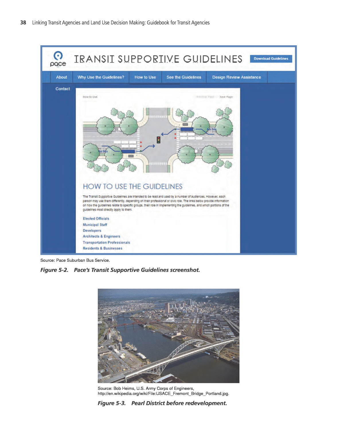
Case Studies 37 champion to advance the cause of transit orientation. Rather, through an ongoing, carefully crafted, collaborative process, transit-supportive principles have become the accepted norm within and outside the organization. Such liaisons have paid off in the form of not only promoting transit- oriented growth but also helping Pace secure competitive grants to finance upgrading of transit- supportive guidelines and initiation of the DRAFT (design review assessment for transit) program. Paceâs experiences show that transit-supportive guidelines play a functional role but can also have a more subtle, nuanced influence on design practices. Thanks to a user-friendly and visually attractive website that relies less on text and more on illustrations, Pace has successfully advanced transit-friendly design principles in ways that appeal to multiple stakeholder interests. Yet it has been behind-the-scenes interactions with highly knowledgeable and devoted Pace staff members where, all sides agree, the transit agency has had the greatest influence in making people aware and mindful of the benefits of transit orientation. Paceâs experiences show that informal processes can be as important as formal documents in influencing outcomes. The case study of the Pace transit system also highlights the importance of the following elements of the transit and land use program: ⢠The behind-the-scenes interactions with Pace staff members have had the greatest influence. Informal processes have proven to be as important as formal documents in influencing outcomes. ⢠The process of advancing transit-supportive development can be every bit as important as the end-products (i.e., guidelines or built environments). ⢠The engagement of as many people as possible as early in the development process as pos- sible through an ongoing, collaborative process has allowed transit-supportive principles to become the accepted norm within and outside Pace. ⢠The packaging of information and illustrations for different audiences is an effective tool for presenting guidance and explaining why transit-supportive practices are important. ⢠The organizational culture embraces land use planning and urban design as a central mission of Pace. A unique feature of the online guidelines is the packaging of information and illustrations for different audiencesânotably, elected officials, municipal staff, developers, architects and engi- neers, transportation professionals, residents, and businesses. Figure 5-2 shows a screenshot of Paceâs Transit Supportive Guidelines; the site provides links for how the guidelines might be used by different stakeholder interests. Further information on these tools can be found in Appendix C or on the Pace website (http:// www.pacebus.com/). TriMet â Portland Pearl District Transit and Land Use Integration The Pearl District is a redeveloped urban neighborhood located just north of Portlandâs tra- ditional downtown. Like many urban neighborhoods that developed or were redeveloped near downtowns in the late 1990s and early 2000s, the Pearl District saw a tremendous amount of growth and development success that continues today. In 1990, 1,643 people lived in Census Tract 51, which makes up most of the Pearl District. As shown in Figure 5-3, the predominant land use in the area before the redevelopment of the Pearl District was rail yards and light indus- trial/warehouse uses. The Portland streetcar, which serves the district and other parts of the city, began operations in 2001. Today the Pearl District is a thriving mixed-use precinct served by the streetcar and buses; its population increased to 7,926 in 2010.15 Transportation agencies, including regional transit provider TriMet and the Portland Bureau of Transportation, helped influence the basic thinking of how transportation and land use should
38 Linking Transit Agencies and Land Use Decision Making: Guidebook for Transit Agencies Source: Pace Suburban Bus Service. Figure 5-2. Paceâs Transit Supportive Guidelines screenshot. Source: Bob Heims, U.S. Army Corps of Engineers, http://en.wikipedia.org/wiki/File:USACE_Fremont_Bridge_Portland.jpg. Figure 5-3. Pearl District before redevelopment.
Case Studies 39 interconnect in the Pearl District through specific policies that were adopted during the state, regional, downtown, and local planning processes as well advocated for by local actors such as the founders of Portland Streetcar, Inc. More visible examples of the Pearl Districtâs transportation legacy include the construction of the streetcar and the continuation of the street grid. Following two decades of linking the land use and transportation planning processes, the Pearl District has evolved into a place where, in 2008, 58 percent of residents reported using modes other than driv- ing to get to work.16 By developing space in the district that encourages the movement of people instead of cars, the Pearl District has become a desirable place to live. It can be difficult and costly for transit agency staff to devote enough time to follow each indi- vidual development project. Alternatively, the planning processes that predated the creation of the Pearl District and Portland streetcar made it easy for the local government, the community at large, and developers to advocate for transit-supportive outcomes. This was done through the transportation agencies and advocates immersing themselves in long-term planning processes in a sustained manner rather than focusing on individual development proposals. In summary, the best way for a transit agency to influence land use decisions is to be involved early in the overall planning process for a region, downtown, or district. Later, if the long-term planning was performed correctly, the developerâs need for transportation improvements will give city and regional transit agencies more leverage on the project. In addition, a land use and transit partnership is highly dependent on effective communication between agencies, stakehold- ers, and the public. It was sustained formal and informal coordination among many people, rather than a dominant single entity, that led to successful completion of the various plans and, ultimately, the creation of the Pearl District. The key stakeholders need to be engaged, and they, in turn, need to engage others to participate in the land use and transportation planning processes. The case study highlights how a sustained partnership, even if it is informal, can help deliver a new transit service that is complementary to the transit agencyâs core business and attain desired land use outcomes. The prioritization of access through transit and walking was a major part of the downtown planning process and has resulted in the great success of the Pearl District. The Pearl District case study shows the value of the following points in creating transit-supportive outcomes: ⢠Sustained formal and informal coordination among many people rather than the presence of a dominant single entity; ⢠Continuous involvement (even informally) over a period of time (e.g., decades) with local governments to build partnerships, awareness, and support; ⢠A transit agency board and mission that support an advocacy role in land use (i.e., the transit agency has a broader role than just being a means to move people); and ⢠Full-time staff that speak the development language, have relationships with the development community, and understand developer priorities and aversion to risk. Additional information on TOD in the Pearl District can be found in Appendix C or at TriMetâs website (https://trimet.org/). GCRTA â Cleveland HealthLine and Greater University Circle Initiative Cleveland, the central city in northeastern Ohio, has been shrinking for decades. At its peak in 1950, almost 1 million people called the city home. Through years of economic and indus- trial decline, the population decreased significantly, to 390,000 in 2013.17 The region has expe- rienced its own population changes, but overall has steadily balanced itself during national
40 Linking Transit Agencies and Land Use Decision Making: Guidebook for Transit Agencies economic swings to maintain some equilibrium in population. In a much championed effort of collaboration, the city, GCRTA, community foundations, and local anchor institutions focused their efforts on creating an economically thriving region, using the bus rapid transit route, the HealthLine along the Euclid Avenue corridor, as a driver for growth. The HealthLine is managed through GCRTA. The 6.8-mile Euclid Avenue corridor stretches from downtown Cleveland east toward Cleve- land Heights and connects downtown, midtown, and a major hospital and university district known as University Circle. This important corridor has been the center of transportation dis- cussions for decades given its role as an employment destination and home of major employers such as the Cleveland Clinic and other health care and university institutions, which make up a solid base of employment for at least 50,000 people.18 The corridor is also home to over 10,000 residences. Clevelandâs University Circle acts as the cultural heart of the region and has established itself as a national leader in innovation and technology transfer. Figure 5-4 shows the infrastructure and streetscape improvements associated with the HealthLine bus rapid transit (BRT) route in downtown Cleveland. When completed in 2008, the street reconstruction with utility relocation, street treatments, and new BRT lanes (costing $200 million of primarily federal funding) resulted in greater con- nections between major destinations in the corridor and seven local neighborhoods. The transit line and related investments knit together several nodes of existing and potential development. The corridor can also show success on several other fronts: ⢠Travel time was cut by 12 minutes, ⢠The previously crowded No. 6 bus added over 7,000 riders and now reaches over 15,000 riders per day, ⢠Economic development and investments along the corridor have totaled $5.8 billion, and ⢠Street improvements are projected to have a useful life of 50 years before needing repairs.19 In addition, neighborhoods, which previously felt disconnected from the economic engines of the community in the universities, hospitals, and major employment center downtown, are now experiencing significant investment and increased property values. All of these factors con- tributed to the corridorâs Urban Land Institute (ULI) award for economic development as well its achievement of a silver ranking in BRT by the Institute for Transportation and Development Policy. Source: http://commons.wikimedia.org/wiki/File:Downtown_Cleveland_ Euclid_Avenue.jpg. Figure 5-4. Euclid Avenue.
Case Studies 41 Key takeaways regarding the HealthLine case study are: ⢠The GCRTA board did not necessarily advocate for involvement in shaping the land use deci- sions but supported the infrastructure investment along the transit corridor to set the stage for transit-supportive land use. ⢠By being involved from the beginning, the transit agency was able to set the proper framework for the corridor. The transit agency could then focus on optimizing its system, creating reli- able transit, and building out any station areas through joint development. ⢠Unconventional partners lead to more successful outcomes. In the transit planning process, because of the long timeline for federal funding, more opportunities were taken to involve both public and private stakeholders. GCRTA outreach and the development of awareness of the project likely led to greater coordination later on. The Greater University Circle leader- ship group (developed in part by the Cleveland Foundation), the institutions, and other cor- ridor stakeholders created a structure for future sharing and collaboration to strengthen ties between all the groups that remain important. The partnershipâs commitment to mobility for all increased opportunities for employment opportunities and fostered a sense of project ownership in lower-income populations. ⢠Partnerships, people, and relationships are important. The best project outcomes occurred where the transit agency, land use planners, and funders had an established relationship and open process for communication. Long-term relationships are a running theme for planning successful integration of transit and land use. More information on GCRTAâs HealthLine can be found in Appendix C or at the HealthLine website (http://www.rtahealthline.com/).
