
4 Mitigating Groundwater Model Uncertainties
KEY TOPICS
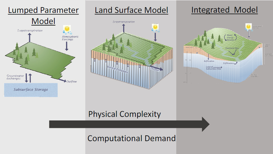
Frontiers in groundwater modeling were illustrated by Dr. Laura Condon (University of Arizona). Models can be useful for bridging scaling gaps, especially for large scale decision-making and covering large scale systems in a way that is relevant for planning. Physically based models can also be used to diagnose process differences (Meixner et al., 2016). It is important to get the water balance right, but it is also important to understand the recharge mechanisms. There are three main approaches to groundwater modeling: lumped parameter global water balance models; global land surface models; and regional integrated modeling, which solves 3D variably saturated flow in the sub-surface and is much more computationally intensive (see Figure 4.1). She highlighted two examples of integrated modeling over large scales, including ParFlow CONUS and TerrSysMP–Cordex in Europe (Keune et al., 2016). In particular, TerrSysMP can be used for short term forecasting, coupled with weather models, to understand how adding groundwater storage into the system changes moisture convergence and predictions across Europe. Physically based groundwater simulations can be used to better understand spatial patterns in groundwater and surface water interactions and potential biases of simplified approaches (Condon and Maxwell, 2015). Simulating groundwater can be used to interrogate more conceptual models that can then be used to understand water balances. Also, integrated models can be used as a tool to characterize the role of groundwater in hydrologic systems. Integrated models can help with residence time distributions, which are important for understanding flow paths (Maxwell et al., 2016); comparing to land surface behavior to see contributions to transpiration (Maxwell and Condon, 2016); and the role of storage changes in surface water partitioning (Condon and Maxwell, 2017).
There are limitations associated with modeling including challenges with large amounts of data. Dr. Condon noted that there is an increase in available sub-surface data, but this is not necessarily a large advancement in terms of the number of in situ observations; even with better gridded data sets to build the models, it is still important to consider the types of data used. Knowledge regarding long-term storage trends and global models tend to underestimate the trends is still not clear, and even with GRACE for comparisons, uncertainty exists about what the storage trends will be in the future and the associated low frequency variability. As mentioned previously, human systems are still lacking in most physically based modeling platforms
even though they are crucial (Abbott et al., 2019). It is important to note that variability in the sub-surface can be largely driven by human behavior.
Dr. Stacey Archfield (USGS) shared information about a large congressionally mandated project at USGS to model the Mississippi alluvial plain, a human-dominated aquifer. It is important to consider how to properly constrain groundwater modeling with surface water in data-sparse regions and complex hydrogeology. She also discussed the relationship between groundwater depletion and trends in low flows and low flow extremes. The confounding effects of different aspects that affect the groundwater depletion makes it difficult to find strong correlations between low stream flows for the principle aquifers and groundwater depletion. Other factors like precipitation are coming into play across the United States, and this confounds the effects of how streamflow depletion relates to low flow extremes. She also mentioned recent work to transfer information from gaged to ungaged locations and how that might relate to groundwater, especially where wells are monitored at high temporal resolution. This is particularly true for groundwater and surface water coupled stream gauges.
Dr. JT Reager (Jet Propulsion Laboratory) noted that recent advancements in remote sensing and new satellite missions have provided observations of almost every aspect of the terrestrial water cycle (see Figure 4.2). The next challenge is how to add integrated value to all of these measurements in unison. The recent decadal survey (NASEM, 2018) highlighted some major questions in the field of hydrology and suggestions for future observing priorities. In that context, it is important to map information gaps between the missions that exist and proposed future missions. In the field of groundwater, for instance, information from in situ measure-

ments, airborne EM techniques, InSAR missions, and GRACE missions all provide insights at different spatiotemporal resolutions and coverage. Numerical modeling and data assimilation, with appropriate uncertainty quantification, is a contextual framework in which researchers can incorporate a observations, to provide quantified meaning and value to new observations.
Dr. Reager considered how to understand the uncertainty of a system as opposed to the uncertainty of a measurement. Typically, researchers consider uncertainty of a measurement (i.e., instrument error) and the forward propagation of uncertainty for a single variable. However, it may be as important to consider how uncertainty propagates across processes and how a new measurement decreases the general domain uncertainty. If uncertainty of the modeling system can be estimated well and new measurements are added with some uncertainty, the total “domain uncertainty” can be quantified and the effects on other variables can be seen. Thus, a goal for modeling activities, through the combination of modeling and observations, is contextualizing and combining unique pieces of information but doing so with proper uncertainty quantification. This enables the ability to understand how much uncertainty remains in a system and, therefore, where the gaps in information are and where to target future observations. In practice, the assimilation algorithm generates a “posterior uncertainty” from a “model prior” then updates with both the observation and the uncertainty of the observation. The result is a best estimate of the state, as well as a best estimate of the uncertainty on the state.
DISCUSSION
Dr. Elizabeth Eide (National Academies) raised a question regarding integrated modeling and asked about the ideal time scales of applicability of the modeling. Current understanding of surface water and the timescale for water flowing through shallow groundwater systems is different than deep groundwater systems. Given that seasonal to sub-seasonal modeling is particularly challenging, if longer term climate models are combined with groundwater modeling, it is important to know the applicability of the time scale for the results of the model and where there may be challenges for bringing modeling results into time scales that have applicability for decision-making. Dr. Condon replied that there are several important timescales to consider. For weather timescale forecasting, it is important to have the antecedent moisture condition correct and there are benefits to having the deeper sub-surface included. This may be easiest to achieve in many ways because data assimilation can be done. Incorporating better storage terms into the global models for decadal scale forecasts will be important and that is where there has been recent work using GRACE to show longer term storage trends that may be missed in the global models. There is much to gain from incorporating the larger storage term, but whether this is done with integrated modeling as opposed to some other more simplified approach that is incorporated into the land surface models is not necessarily clear. It may be somewhere in between the two. Integrated models can do a better job of understanding how the more simplified storage terms will behave.
Dr. Rodell raised concerns about recent work to test models that were not meant to simulate trends. If the goal is to better simulate trends, it would be useful to focus on that specifically without expecting the models to be able to do this well, now. GRACE information can be used as a target for trends. Dr. Condon agreed and noted that researchers would like to start applying models in this way and the recent research suggests that more work needs to be done. She also agreed that GRACE data can provide trends during the time periods for which observations exist, but the period of record does not necessarily represents the variability of the system. Using that period of record alone to test whether low frequency variability in storage dynamics is correct requires a great deal of confidence in the models. Dr. Rodell noted that development of better models with this specific purpose in mind will be needed if the goal is to understand the longer term variability. Inputs (such as precipitation) will also play a large role in developing accurate models.
In a more traditional groundwater modeling framework, Dr. Rajaram noted that the use of models for groundwater management has historically been an approach to parameter estimation and involved some sense of what the in situ data really meant. For data assimilation, it is desirable to have both model prediction and prediction uncertainty as well as measurements with less uncertainty overall in order to increase understanding. With remote sensing based observations that required processing down to an inferred quantity, there is a state of the art in terms of using large scale remote sensed observations in data assimilation or classical groundwater modeling approaches. Dr. Reager noted that there is a project to work with California on critical groundwater management regions, where compliance with sustainable levels of groundwater withdrawals need to be demonstrated by 2022. This includes mitigation
of subsidence, which is associated with unsustainable groundwater withdrawals. The project will use the Central Valley hydrological model with a routine in the model to simulate subsidence. Using observations at coarse scale, incorporating well observations where available, and InSAR observations of subsidence, the model is calibrated for use in different regions. Dr. Condon noted that there may be a disconnect in the data sets and the methods that are used for large scale models and for regional and smaller scale models. There are useful groundwater models that are built on watershed scales in collaboration with the stakeholders in the specific areas that will be using the information. There is an opportunity to facilitate better communication between all of the models that have already been built on small scales and those on large scales in heavily studied regions. Dr. Archfield added that the surface water modeling community is struggling with this as well. Different modeling communities are all approaching scales that are needed for management activities, and it may be beneficial to seek common areas that could be solved by these different communities working together to take advantage of efficiencies.
Dr. Nguy-Robertson asked if the roadblock for data assimilation involves a lack of data itself or a lack of meta-data to help understand what is available and the adequacy of the data for use in the models. Dr. Condon mentioned that there may not be roadblocks regarding data availability or methods for data assimilation; rather, the limiting factor with respect to groundwater recharge and flow may be the lack of data sets to assimilate.
Dr. Lakshmi asked about depth to water table, the availability of the information, and how it can be obtained globally. Dr. Archfield noted that USGS collects these data in 15 minute intervals in groundwater wells throughout the United States; however, she noted, they have not been extrapolated between the wells on a continental scale. There are also areas where groundwater data, surface water data, and stream gage data are being collected in the same locations, but the data are not analyzed together with great frequency. It is important to ensure that the data being collected are being analyzed and used, she concluded. Dr. Condon also noted the work being done on a global groundwater map which is the gold standard in terms of collecting all global water table depth observations and combining them together in a simple model. All of the other large-scale models being developed are compared to this map, even though the locations of the data are biased toward areas that have many wells in use. Dr. Archfield added that data gaps and their implications for new data collection activities are important considerations, particularly in areas of challenging hydrogeology where the existing information may be sparse.
Dr. Lall asked if, for the United States, it would be possible and worthwhile to assemble all of the well data and hydrostratigraphy information—the “vertical” information sets—together with models at the continental scale. Dr. Condon replied that it would be beneficial to pull together this information, particularly the hydrostratigraphy, which is a limiting factor in terms of mapping where alluvial aquifers exist and understanding the depth to confining units. This kind of compilation could be important to constrain the configuration of groundwater aquifers over large scales. Dr. Minsley replied that one of the challenges is missing the nonlinear features in the sub-surface. A small window in the confining layer that promotes flow through it might be missed with even a thousand wells, and this illustrates the value of providing high resolution geophysics to identify the geometry of the aquifer system to reduce uncertainties in
making predictions. He provided the caveat that it depends on the question being asked and the scale of interest as well; in some cases the hydrostratigraphy may not matter, for example. It is nearly impossible to produce models that can do everything, because of the complexity of the systems. Thus, uncertainties can be defined around specific management questions.
Dr. Lall pointed out that the discussions did not delve into the types of aquifers, and he wondered about many critical areas around the world and whether there is adequate representation of the issues associated with different types of aquifers. Dr. Condon replied that the integrated modeling work is primarily focused on shallow groundwater and understanding what that means for land-surface connections and connecting from the atmosphere down. A separate set of questions exists for deep aquifers, where the land surface likely does not need to be coupled for the time scales of interest. The tools and the modeling for these systems are all likely to be somewhat different, and groundwater hydrologists have to work in these systems as well.
During the third set of breakout group discussions, participants reflected on the modeling frontiers discussed in the panel and identified the most important modeling uncertainties. Input, data and physical and conceptual models and their outputs have many types of uncertainties which translate to eventual use of the outputs by end users. For example, pumping data are not available on the timescales at which the models are run, and this is applicable for management questions and human interactions. Some participants suggested that subsidence from remote sensing could be integrated into the models as a proxy for pumping. Others mentioned uncertainty in storage capacity of the aquifer and quality of the water (e.g., saline versus fresh, geogenic and anthropogenic contaminants), hydrostratigraphy for deep aquifers, sub-surface properties and the order of magnitude of their variability. There are also uncertainties associated with time scales (seasons, events, etc.), and spatial and temporal scales are often driven by management questions. In this sense, early stakeholder involvement in developing the questions that groundwater modelers are trying to answer can help ensure that the right model is developed for the desired temporal and spatial scale.
Joint groundwater and surface water modeling could also be a significant step forward for water managers, as well as an increased understanding of the resiliency of unconventional aquifers. As previously noted, human elements and behaviors, including policy and governance issues, groundwater regulation, and legal frameworks are important to understand. Integrating the human scale and socioeconomic issues into the models can assist decision-makers. Understanding how to parameterize the human behavior and decision-making may provide opportunities to work with social scientists and to facilitate interdisciplinary communication.
The groups also explored the types of data that could be most useful in minimizing model uncertainties. Importantly, obtaining more of the data that already exist and maximizing these existing data sets will be crucial, particularly for data assimilation. As previously noted by panelists, large-scale AEM surveys and geophysical data can provide improved spatial representation of aquifers, and GRACE can be used as input data for models as well as evaluation of the modeling in a diagnostic way, thereby identifying uncertainties and improving parameterization. Subsurface hydrologic properties and water properties such as quality, salinity, and age are all important, but the raw data are not sufficient; confidence intervals, synthesis, analysis are desired to be sure that the data can be adequately integrated.
Breakout participants reiterated that new data science techniques and computational tools such as artificial intelligence can be used to refine modeling capabilities. In terms of model outputs, distribution for reuse, metadata and format are crucial components, and policies and agencies have a role to play in this type of coordination to maximize reuse of the data. Model parameters from academia are more readily available, but this is not necessarily the case for models developed by consultants, agencies, and governments. It would be useful to have data that help to understand how developed versus less developed countries manage aquifers. Human data may be difficult to obtain (e.g., unemployment data in cities and crop forecasting), but there are opportunities to use remote sensing. In fact, insights from data in the United States can help develop methodology to deal with sparsity of data sets in other parts of the world.
Resources that would be particularly useful to improve groundwater modeling include: high spatial resolution satellite imagery to identify water infrastructure and groundwater use for irrigation (in particular, geostationary satellite imagery to obtain high temporal resolution); soft data to inform the human relationship with groundwater (e.g., failing crops, electricity usage, and deep wells); a host for model output repository capacities for large data sets and decision-aid tools to inform policy makers and assist local water planners; tools for developing and processing data; water quality information; and information on extreme events and flooding as well as potential effects on wells, contaminants, livestock, coastal processes, and storm surges. Dr. Nguy-Robertson noted mechanisms through which researchers can utilize unclassified data through NGA, including participation in cooperative research and development agreements (CRADAs) between the National Geospaitial-Intelligence Agency (NGA) and academic scientists as well as commercial companies. The NURI program mentioned previously is another pathway to obtain research funding and potentially gain access to relevant data. Understanding the resources and opportunities that are available will help researchers write focused proposals to advance understanding.
In terms of collaboration opportunities, many participants suggested a potential USGS, NGA, NASA, and university partnership to process information, conduct model simulation, and utilize machine learning to maximize analysis and understanding. Although this would likely be U.S.-centric at first, this kind of interagency and interdisciplinary collaboration could serve as an analog for missing data in other regions of the world. Interdisciplinary efforts such as the National Council of Examiners for Engineering and Surveying (NCEES), the National Socio-Environmental Synthesis Center (SESYNC), and EarthScope can provide guiding examples. A key message is that stakeholder participation would be most beneficial at the beginning of the discussion, and this can help enhance interactions between social science and geoscientists. A two-way conversation could help ensure that the tools and modeling are accessible to a wide variety of stakeholders.
This page intentionally left blank.


