


Below is the uncorrected machine-read text of this chapter, intended to provide our own search engines and external engines with highly rich, chapter-representative searchable text of each book. Because it is UNCORRECTED material, please consider the following text as a useful but insufficient proxy for the authoritative book pages.
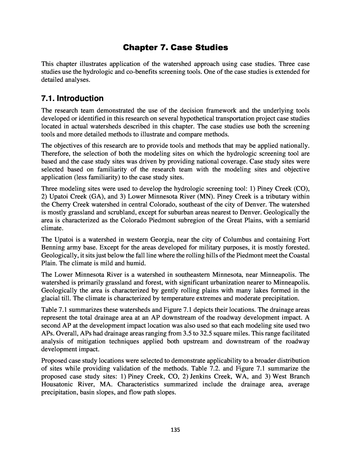
135 Chapter 7. Case Studies This chapter illustrates application of the watershed approach using case studies. Three case studies use the hydrologic and co-benefits screening tools. One of the case studies is extended for detailed analyses. 7.1. Introduction The research team demonstrated the use of the decision framework and the underlying tools developed or identified in this research on several hypothetical transportation project case studies located in actual watersheds described in this chapter. The case studies use both the screening tools and more detailed methods to illustrate and compare methods. The objectives of this research are to provide tools and methods that may be applied nationally. Therefore, the selection of both the modeling sites on which the hydrologic screening tool are based and the case study sites was driven by providing national coverage. Case study sites were selected based on familiarity of the research team with the modeling sites and objective application (less familiarity) to the case study sites. Three modeling sites were used to develop the hydrologic screening tool: 1) Piney Creek (CO), 2) Upatoi Creek (GA), and 3) Lower Minnesota River (MN). Piney Creek is a tributary within the Cherry Creek watershed in central Colorado, southeast of the city of Denver. The watershed is mostly grassland and scrubland, except for suburban areas nearest to Denver. Geologically the area is characterized as the Colorado Piedmont subregion of the Great Plains, with a semiarid climate. The Upatoi is a watershed in western Georgia, near the city of Columbus and containing Fort Benning army base. Except for the areas developed for military purposes, it is mostly forested. Geologically, it sits just below the fall line where the rolling hills of the Piedmont meet the Coastal Plain. The climate is mild and humid. The Lower Minnesota River is a watershed in southeastern Minnesota, near Minneapolis. The watershed is primarily grassland and forest, with significant urbanization nearer to Minneapolis. Geologically the area is characterized by gently rolling plains with many lakes formed in the glacial till. The climate is characterized by temperature extremes and moderate precipitation. Table 7.1 summarizes these watersheds and Figure 7.1 depicts their locations. The drainage areas represent the total drainage area at an AP downstream of the roadway development impact. A second AP at the development impact location was also used so that each modeling site used two APs. Overall, APs had drainage areas ranging from 3.5 to 32.5 square miles. This range facilitated analysis of mitigation techniques applied both upstream and downstream of the roadway development impact. Proposed case study locations were selected to demonstrate applicability to a broader distribution of sites while providing validation of the methods. Table 7.2. and Figure 7.1 summarize the proposed case study sites: 1) Piney Creek, CO, 2) Jenkins Creek, WA, and 3) West Branch Housatonic River, MA. Characteristics summarized include the drainage area, average precipitation, basin slopes, and flow path slopes.
136 Table 7.1. Modeling site summary. Watershed Location Downstream AP Drainage Area (mi2) Impact AP Drainage Area (mi2) Average Annual Precipitation (in) Piney Creek Southeast of Denver, CO 21.9 15.1 20 Upatoi Creek Western Georgia near Columbus 32.5 16.6 50 Lower Minnesota River Southeastern Minnesota 6.9 3.5 30 Figure 7.1. Modeling and case study locations. Table 7.3 summarizes the land cover types as recorded in the National Land Cover Database (NLCD) for 2016. To provide a wider range of land covers, the table shows a modified Housatonic watershed that reflects potential future development in and around the City of Pittsfield. The modified Housatonic can be considered what it might look like in the future, e.g., in 2030.
137 Table 7.2. Case study site summary. Characteristic Piney Creek Jenkins Creek West Branch Housatonic River Location Southeast of Denver, CO Southwest of Seattle, WA Western MA near Pittsfield Drainage area (mi2) 21.9 9.4 36.4 Average annual precipitation (in) 20 50 46 Basin slope (ft/ft) 0.0774 0.0533 0.1422 Maximum flow distance (ft) 74,262 30,331 75,556 Maximum flow slope (ft/ft) 0.0105 0.0095 0.0216 Case study type Screening and detailed Screening only Screening only Table 7.3. Case study site land cover summary. NLCD Code Land Cover Type Piney Creek (percent) Jenkins Creek (percent) West Branch Housatonic River (percent) West Branch Housatonic River (2030/ mod) (percent) 11 Open water 0 2 5 5 21 Developed, open space 34 25 7 7 22 Developed, low intensity 16 25 4 10 23 Developed, medium intensity 14 8 4 10 24 Developed, high intensity 2 1 1 6 31 Barren land (rock/sand/clay) 0 1 0 0 41 Deciduous forest 0 4 53 27 42 Evergreen forest 1 6 1 1 43 Mixed forest 0 20 10 10 52 Shrub/Scrub 5 2 0 0 71 Grassland/herbaceous 28 1 0 0 81 Pasture/hay 0 1 9 9 82 Cultivated crops 0 0 0 9 90 Woody wetlands 0 4 5 5 95 Emergent herbaceous wetlands 0 0 0 0 The research team examined other more highly urbanized locations but found that these sites are located on watersheds too large for these case studies. For watersheds that are too large, the effects of individual transportation projects and the potential mitigation techniques will not be measurable for the selected hydrologic metrics. It is also unlikely that highly urbanized (developed high intensity in the NLCD) areas would ever be converted to forest or wetlands and the opportunities for stream restoration/floodplain reconnection in these areas are limited.
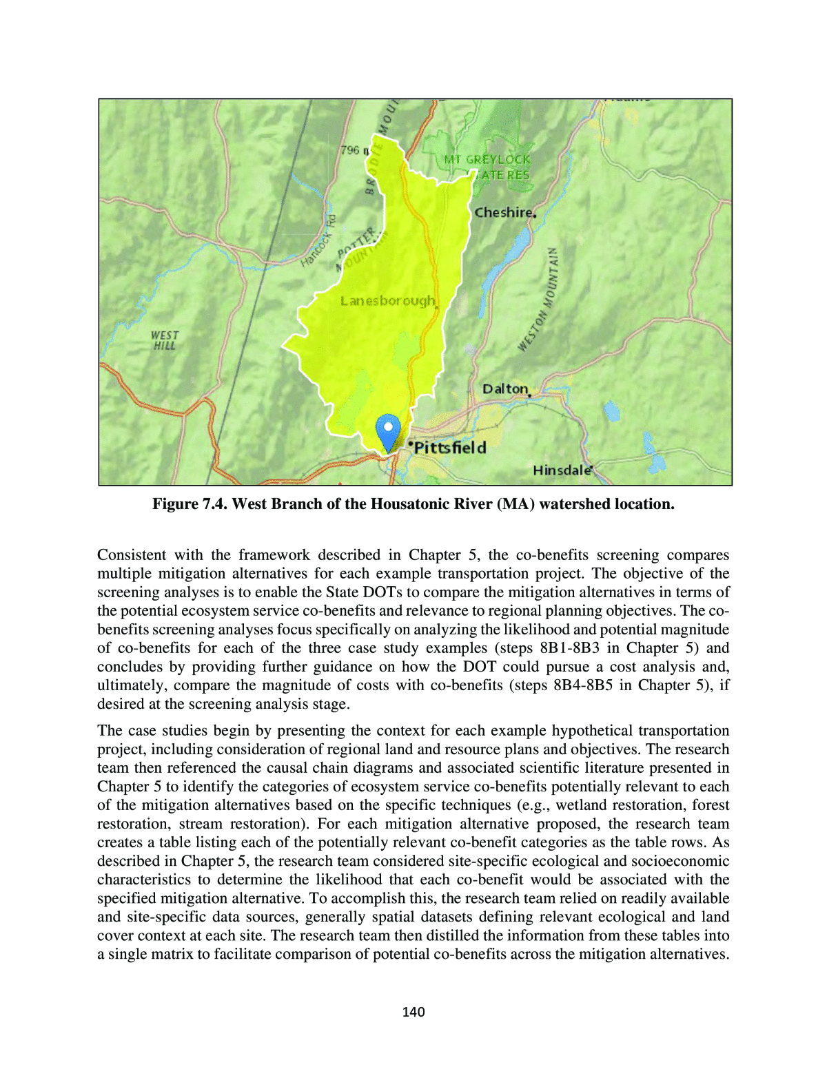
138 Therefore, altering the Housatonic watershed provides a larger range of urban/suburban development and the opportunity for evaluating agriculture. Although the case studies will not evaluate stormwater trading, such an approach may become a viable vehicle for more urban watersheds in the future. The Piney Creek watershed (shown in Figure 7.2) was used to develop the hydrologic screening tools. The watershed is used herein to demonstrate the hydrologic and co-benefits screening and to demonstrate the use of detailed techniques. The lower AP is designated at the confluence of Piney Creek with the larger Cherry Creek. A second AP is located where highway E-470 cuts across the watershed. The watershed is largely developed with active development in some areas. The Jenkins Creek watershed (shown in Figure 7.3) is part of the Green River watershed southwest of Seattle. Tahoma National Cemetery covers a major part of the watershed. The lower AP is defined as the crossing of the creek with Route 18 (Auburn-Echo Lake Cutoff Road) near Covington. Hydrologic and co-benefits screening analyses will be performed for this site using two APs, one at the outlet and one at the roadway impact. The roadway impact site is based on hypothetical modifications of Route 18 and portions of the roads feeding Route 18. The watershed is largely developed with some wooded areas. The West Branch of the Housatonic watershed (shown in Figure 7.4) lies primarily north of Pittsfield MA. U.S. Highway 7 runs north-south in the watershed and the outlet of the watershed is defined as the crossing of U.S. 20 (West Housatonic Street). The watershed to this point is 64 percent forested (see Table 7.3). Hydrologic and co-benefits screening analyses will be performed for this site using two APs, one at the outlet and one at the hypothetical roadway impact site. The proposed baseline scenario for the Housatonic screening is the future (2030/modified) condition described in Table 7.3. This scenario provides for a higher level of urban and agricultural development to broaden the ranges represented in the three case study sites. Table 7.4 summarizes the mitigation measures evaluated at the case study locations. These measures were evaluated independently and working in combination in the Piney Creek case study. Agricultural practices modification is considered only as a hypothetical as a hydrologic screening tool has not been developed for assessing the hydrologic performance of this mitigation alternative. Hydrologic metrics that were evaluated include the event peak and volume for both the 2-yr and 100-yr events. Table 7.4. Mitigation alternatives evaluated in the case studies. Case Study Mitigation Alternatives Jenkins Creek Forest restoration, wetlands restoration West Branch Housatonic (2030) Forest restoration, wetlands restoration, agricultural practices modification Piney Creek Stream restoration, uplands restoration
139 Figure 7.2. Piney Creek (CO) watershed location. Figure 7.3. Jenkins Creek (WA) watershed location.
140 Figure 7.4. West Branch of the Housatonic River (MA) watershed location. Consistent with the framework described in Chapter 5, the co-benefits screening compares multiple mitigation alternatives for each example transportation project. The objective of the screening analyses is to enable the State DOTs to compare the mitigation alternatives in terms of the potential ecosystem service co-benefits and relevance to regional planning objectives. The co- benefits screening analyses focus specifically on analyzing the likelihood and potential magnitude of co-benefits for each of the three case study examples (steps 8B1-8B3 in Chapter 5) and concludes by providing further guidance on how the DOT could pursue a cost analysis and, ultimately, compare the magnitude of costs with co-benefits (steps 8B4-8B5 in Chapter 5), if desired at the screening analysis stage. The case studies begin by presenting the context for each example hypothetical transportation project, including consideration of regional land and resource plans and objectives. The research team then referenced the causal chain diagrams and associated scientific literature presented in Chapter 5 to identify the categories of ecosystem service co-benefits potentially relevant to each of the mitigation alternatives based on the specific techniques (e.g., wetland restoration, forest restoration, stream restoration). For each mitigation alternative proposed, the research team creates a table listing each of the potentially relevant co-benefit categories as the table rows. As described in Chapter 5, the research team considered site-specific ecological and socioeconomic characteristics to determine the likelihood that each co-benefit would be associated with the specified mitigation alternative. To accomplish this, the research team relied on readily available and site-specific data sources, generally spatial datasets defining relevant ecological and land cover context at each site. The research team then distilled the information from these tables into a single matrix to facilitate comparison of potential co-benefits across the mitigation alternatives.
141 At this stage, the research team described for each case study how the DOT might prioritize mitigation options based on ecosystem service co-benefits along with other relevant considerations, including the project context, relative performance of the mitigation alternatives in achieving the primary intended stormwater management objectives, and project costs. 7.2. Screening Analyses The research team completed hydrologic and co-benefits screening of the three case study sites introduced in Section 7.1: Jenkins Creek (WA), West Branch of the Housatonic River (MA), and Piney Creek (CO). The following sections describe the proposed hypothetical transportation project, the mitigation alternatives evaluated, the hydrologic screening, and the co-benefits screening for each case study. 7.2.1. Jenkins Creek Case Study For this case study the hypothetical transportation project is a widening of Route 18 from 208th Avenue to 232nd Street as shown by the thick gray line in Figure 7.5. The downstream AP is defined where Jenkins Creek crosses Route 18 near Covington, WA. A second AP is located just below the transportation project where flow is concentrated into a single stream and is shown in Figure 7.5 as a small yellow point. The drainage area to that AP is represented by the thinner black polygon. Figure 7.5. Hypothetical transportation project in the Jenkins Creek watershed.
142 This segment of Route 18 is nearly 7,900 feet long and the hypothetical project will add 50 feet of width to the right-of-way. The total area of the transportation project is approximately 9 acres. For this analysis it is assumed that the new project impact replaces existing pervious land cover. Estimates for this hypothetical project are that the transportation project impact is 80 percent impervious. Therefore, the net increase of imperviousness for the transportation project is 7.2 acres. If some portions of the existing land cover were also impervious this would reduce the net impact of the transportation project. 7.2.1.1. Hydrologic Screening The State DOT and potential collaborators have identified that forest restoration and/or wetland restoration might be feasible mitigation techniques. This region of the country produces significant runoff, so when using the screening tool, the research team knows to expect significant benefits from mitigating existing impervious land covers (i.e., developed lands) as well as existing pervious land covers (i.e., grasslands, shrub, pasture, and urban pervious). The State DOT and potential collaborators and regulators agree that the 2-yr and 100-yr peak flow and volume are the relevant hydrologic assessment metrics (noting that a separate analysis will be needed to determine whether there is suitable hydrology to support the forest and/or wetland restoration project). Table 7.5 summarizes portions of the hydrologic screening tool for these metrics at both APs (at the transportation project and the downstream AP) as obtained from Appendix D. Table 7.5. Mitigation ratios for consideration in the Jenkins Creek case study (area of mitigation per unit area of new impervious highway impact). Mitigation Type Mitigation Site Assessment Point Mitigation Location 100- yr Peak Flow 2-yr Peak Flow 100-yr Event Volume 2-yr Event Volume Forest Restoration Impervious At Highway Project Upstream 1.4 1.6 1.4 N/A Wetland Restoration Impervious At Highway Project Upstream 2.0 1.6 1.6 1.1 Forest Restoration Pervious At Highway Project Upstream 4.3 N/A 1.3 7.0 Wetland Restoration Pervious At Highway Project Upstream 3.4 N/A 2.4 9.0 Forest Restoration Impervious Downstream Downstream 2.0 1.3 1.6 N/A Wetland Restoration Impervious Downstream Downstream 2.0 1.3 4.0 N/A Forest Restoration Pervious Downstream Downstream 4.1 N/A 2.4 5.0 Wetland Restoration Pervious Downstream Downstream 2.8 N/A 4.8 7.1 N/A â not available as no consistent pattern was detected.
143 The research team observed from Table 7.5 that the screening tool did not produce a value for the 2-year peak flow metric in some cases, and the 2-year event volume metric in others. Therefore, to provide confidence that the mitigation will satisfy these metrics, analysis beyond this screening tool will be needed. Using Table 7.5, the research team identified the largest number on each row, knowing if that metric is satisfied, the other metrics on the row will also be satisfied. For mitigation upstream, multiplied by the impervious portion of the transportation project area, the research team estimated the required mitigation amounts summarized in Table 7.6 Table 7.6. Upstream mitigation amounts to compensate for 7.2 acres of impervious impact for the Jenkins Creek case study. Mitigation Option Mitigation Ratio Mitigation Area (ac) Forest restoration on impervious land (upper AP) 1.6 11.5 Wetland restoration on impervious land (upper AP) 2.0 14.4 Forest restoration on pervious land (upper AP) 7.0 50.4 Wetland restoration on pervious land (upper AP) 9.0 64.8 Figure 7.6 summarizes the land cover distribution from EPA BASINS (using NLCD 2016) at the upper AP. The research team observed from the land cover distribution the area is about 30 percent forest, 25 percent developed low intensity, and 25 percent developed open space. Developed high intensity and developed medium intensity cover less than 10 percent of the watershed. Figure 7.7 shows a spatial view of the land cover categories. The research team first searched for impervious areas for mitigation. The dark red is developed high intensity (77.5 acres) â it might make sense to focus on that for possible mitigation areas. Figure 7.8 shows the largest concentration of high intensity development near the intersection of Route 18 and Route 169 are on the Eastern edge of the study area. An assessment of the aerial imagery shown in Figure 7.9, revealed that the area appears to contain a small shopping center with some service business, a few apartment complexes, and an elementary school. This area likely contains a few 4-acre parcels, possibly a total of 10 acres of impervious land. As at least 11.5 acres of impervious land is needed for mitigation, full mitigation was not achieved using this area alone.
144 Figure 7.6. Land cover distribution at the Upper AP in the Jenkins Creek watershed from EPA BASINS. Figure 7.7. Land cover in the Jenkins Creek watershed.
145 Figure 7.8. Concentration of high intensity land cover in the Jenkins Creek watershed. The research team could consider wetland restoration on a small area near our upstream AP. There is an existing wetland (shown in light blue in Figure 7.10) with some low-density development adjoining it. Since the adjoining development is low density, it is probably only in the range of 30 percent impervious. Five acres at 30 percent impervious translates to 1.5 acres of impervious area, which is less than the 14.4 acres needed for wetland restoration from an impervious land cover. Another option is to mitigate a pervious land cover instead. Figure 7.11 shows an area with a concentration of âdeveloped open space.â From the aerial imagery shown in Figure 7.12, this area appears to be grassland. Scaling from the map, that looks like it might be around 50 acres. Recall from the analysis of the mitigation tables that about 50 acres of pervious area are needed for forest restoration. From the screening tool, it looks like forest restoration in this area would satisfy our criteria.
146 Figure 7.9. Aerial imagery of developed land in Jenkins Creek watershed.
147 Figure 7.10. Area of wetlands in the Jenkins Creek watershed. Figure 7.11. âDeveloped Open Spaceâ in the Jenkins Creek watershed.
148 Figure 7.12. Aerial imagery of grassland in the Jenkins Creek watershed. The research team then searched for mitigation applications downstream of the transportation project. Table 7.7 summarizes the mitigation are computations for this situation. The reader is cautioned that mitigation downstream of the transportation project would not mitigate at the upper AP. One candidate appears to be âdeveloped open spaceâ or âDeveloped Low Intensityâ land near existing wetlands near the downstream AP, as shown in Figure 7.13. It appears little of this land is impervious, so it would respond as urban pervious land. Converting approximately 50 acres of this area to wetland is an option that could be explored further.
149 Table 7.7. Downstream mitigation amounts to compensate for 7.2 acres of impervious impact for the Jenkins Creek case study. Mitigation Option Mitigation Ratio Mitigation Area (ac) Forest restoration on impervious land (lower AP) 2.0 14.4 Wetland restoration on impervious land (lower AP) 4.0 28.8 Forest restoration on pervious land (lower AP) 5.0 36.0 Wetland restoration on pervious land (lower AP) 7.1 51.1 Figure 7.13. Developed land near wetlands in the Jenkins Creek watershed. For this case study the research team concluded that for the chosen hydrologic metrics, either forest restoration in the upper portions of the watershed or wetlands restoration near the downstream AP would both be alternatives worth further exploration. 7.2.1.2. Co-Benefits Screening The sections that follow walk through the five steps for a screening-level assessment of co- benefits and costs outlined in Chapter 5 for the Jenkins Creek case study.
150 7.2.1.2.1. Establish the Project Context (Step 8B1) Mitigation alternatives: This example considers two mitigation alternatives to compensate for the effects of the transportation project. This screening analysis compares the co-benefits that may result from each of these mitigation alternatives at these specific sites so that decision-makers may compare tradeoffs and outcomes across alternatives. The two separate mitigation alternatives described in the hydrologic screening analysis are : ⢠Forest restoration: Afforestation of 36 acres of area currently under grassland (currently âdeveloped open spaceâ) within the upper portion of the watershed (near Maple Valley, Washington); or ⢠Wetlands restoration: Restoration of 50 acres of pervious areas near existing wetlands and near downstream AP (currently âdeveloped open spaceâ and âdeveloped low intensityâ area Covington, Washington), following confirmation from a wetland scientist that wetland restoration would likely be successful. Local objectives: To ensure the selected mitigation alternative fits within the planning objectives of the community, the DOT may choose to consider King Countyâs Comprehensive Plan (2016).20 This plan articulates several overarching goals and priorities, including three with implications for mitigation technique consideration: ⢠Preserving and maintaining open space and natural resource lands. This goal specifically references pursuing âopportunities to preserve and maintain remaining high priority forest, agriculture, and other open space landsâ (p. ES-4). ⢠Addressing health, equity, and social and environmental justice. This goal describes âreduc[ing] health inequities and proactively address[ing] issues of equity, social and environmental justice when evaluating and implementing its land use policiesâ (p. ES-4). ⢠Achieving environmental sustainability. This goal seeks to âprotect, restore and enhance the countyâs natural resources and environment, encourage sustainable agriculture and forestry, reduce climate pollution and prepare for the effects of climate change, including consideration of the inequities and disparities that may be caused by climate changeâ (p. ES-4). In summary, the plan makes multiple mentions of forestry, preparation for the impacts of climate change, and a focus on reducing inequities by pursuing environmental justice. Separately, King County also has a 30 Year Forest Plan and a Strategic Climate Action Plan.21, 22 Both of these documents describe the countyâs goal to plant 1 million trees between 2015 and 2020, a goal which was surpassed. Given this specific attention to afforestation, the county provides opportunities for partnership and funding to help achieve these goals.23 As the county has already met its afforestation goal, the DOT would want to follow up with the county to see if 20 King County Office of Performance Strategy and Budget. 2020. 2016 King County Comprehensive Plan. Available at: https://www.kingcounty.gov/~/media/depts/executive/performance-strategy-budget/regional-planning/2020-Comprehensive- Plan-Update/2016-KCCP-KingCountyComprehensivePlan-updated072420-by-19146.ashx?la=en 21 King County. 2019. âForest policy and planningâ. Available at: https://www.kingcounty.gov/services/environment/water-and- land/forestry/forest-policy.aspx 22 King County. 2021. âKing County Strategic Climate Action Planâ. Available at: https://www.kingcounty.gov/services/environment/climate/actions-strategies/strategic-climate-action-plan.aspx 23 King County. 2019. âPartnerships are key for 1 Million Trees.â Available at: https://kingcounty.gov/services/environment/stewardship/one-million-trees/partner.aspx
151 afforestation projects are still desirable. A quick search did not uncover specific planning documents related to wetlands in the area. The DOT may want to follow up with King Countyâs Department of Natural Resources and Parks to clarify if the county (or more local entities, including the City of Covington, where the proposed wetland restoration would be located) may also have specific objectives and plans related to wetlands, including existing or proposed wetland mitigation banks. Potential collaborators: An investigation of local objectives identified several other groups with interest in forest or wetlands restorations that may serve as potential local collaborators and/or sources of co-funding. A sample of these potential collaborators are listed in Table 7.8. Table 7.8. Potential partners for Jenkins Creek mitigation alternatives. Wetlands restoration Forest restoration King County Small Habitat Restoration Program King County Forestry Program King County Wetland Mitigation Banking Program King County Land Conservation Initiative 7.2.1.2.2. Identify Co-benefits through Established Causal Chains (Step 8B2) Table 7.9 and Table 7.10 describe the likelihood that the forest restoration and wetland restoration alternatives, respectively, may result in specific co-benefits by evaluating site-specific ecological and socioeconomic factors. The ecosystem service co-benefit categories described in the first column reflect those services potentially relevant to the mitigation techniques being evaluated based on the causal chain diagrams provided in Chapter 5. 7.2.1.2.3. Assess Relative Magnitude of Co-benefits (Step 8B3) Table 7.11 summarizes the findings from step 8B2 across the two mitigation alternatives: 1) wetland restoration and 2) forest restoration. Given the emphasis on forest restoration in local planning documents, as well as the potential for funding opportunities, the DOT may want to give the most consideration to the forest restoration alternative. The table also demonstrates that the forest restoration alternative may result in several co-benefits.
152 Table 7.9. Screening assessment of potential co-benefits for forest restoration at Jenkins Creek. Co-Benefit Site-specific ecological factors that contribute to the provision of ecosystem services Site-specific socioeconomic factors that contribute to the value of ecosystem services Likelihood of co- benefit at the mitigation site Increased or improved recreational opportunities The newly generated 36 acres of forest could be established with trails to provide recreation access in the long term once trees have matured and a canopy has been established. Within the downstream drainage area, the following terrestrial species listed as endangered under the ESA have overlapping ranges: Gray wolf, Marbled murrelet, Streaked horn lark, and Yellow- billed Cuckoo.24 These species may become more numerous with more forested habitat and draw recreators in the longer term. To establish the potential demand for recreation in the area, the DOT may want to consider visitation at other local recreation spots. For example, the proposed site is located near the privately managed Shadow Lake Nature Preserve, which spans 92 acres, includes trails, and offers access to unique habitat conditions. A quick survey of the immediate area suggests there are no other large, forested areas that offer forest recreation. This co-benefit is likely associated with this project, but only in the long term once the forest canopy and habitat conditions have matured. Improved landscape aesthetics The DOT and its collaborators would have a choice of the number and types of trees planted through afforestation efforts. The choice of trees could consider local aesthetic preferences of nearby homeowners and potential recreators. For instance, the DOT may choose to select some of the 25 species of evergreens native to Washington not only for their ecosystem benefits, but also for their aesthetic favorability.25 For perspective regarding the size of the population potentially benefiting from the improved aesthetics, there are 35 residential properties within approximately 1,000 feet of the proposed mitigation site. Once the DOT determines the exact boundaries of the proposed site, it could refine the count of the number of properties with direct visibility of the proposed site.26 The DOT could also apply its research on the number of potential recreators to this co-benefit as well. Recreators who may visit the site in the longer term are also expected to experience the aesthetic co-benefits. This co-benefit is likely associated with this project. 24 USGS. 2018. Protected Areas Database (PAD-US) 2.0 National Geodatabase. Available: https://www.usgs.gov/core-science- systems/science-analytics-and-synthesis/gap/science/pad-us-data-download?qt-science_center_objects=0#qt- science_center_objects. 25 Washington Forest Protection Association. 2020. âTrees of Washingtonâs Forests.â Available at: https://www.wfpa.org/sustainable-forestry/tree-species/ 26 King County. 2021. Property layers for iMap. Available at: https://gismaps.kingcounty.gov/iMap/?mapset=hazards
153 Co-Benefit Site-specific ecological factors that contribute to the provision of ecosystem services Site-specific socioeconomic factors that contribute to the value of ecosystem services Likelihood of co- benefit at the mitigation site Improved drinking water quality The area adjacent to the proposed forest afforestation site is considered low for drinking water contamination susceptibility under baseline conditions.27 The immediate area includes a mix of private and groundwater wells, with approximately half of the population receiving their drinking water from each.28 If the DOT required more specific numbers, the U.S. Census data from 1990 provides a detailed count of dwellings by water access type. The proposed site is in the Green River Watershed. The DOT may want to contact King Countyâs Department of Natural Resources and Parks to ascertain the number of people served by interconnected water supply.29 This co-benefit is unlikely to be associated with this project because baseline water quality appears high. Improved human health and welfare See âimproved drinking water qualityâ co-benefit for factors associated with drinking water. The DOT and its collaborators would have a choice of the number and types of trees planted through afforestation efforts. The choice of trees could consider the ability of trees to absorb air pollutants and decrease local temperatures. Experts at the King Countyâs Forestry Program could assist in this effort.30 See âimproved drinking water qualityâ co-benefit for factors associated with drinking water. Nearby residents and recreators may experience the health benefits associated with increased air quality and decreased local temperatures during summers. This co-benefit is likely associated with this project, but only in the long term once the forest canopy has matured. Timber and forest product harvest benefits (resource harvesting) The proposed site is not expected to be managed for resource extraction. The proposed site is not expected to be managed for resource extraction. This co-benefit is unlikely to be associated with this project because it is unlikely that the forest restoration would result in opportunities for resource harvesting. 27 King County. 2020. Map layers related to the King County groundwater program. Available at: https://gismaps.kingcounty.gov/iMap/?mapset=hazards 28 King County Water and Land Services. 2010. Groundwater Well Viewer. Available at: https://green2.kingcounty.gov/groundwater/map.aspx 29 King County Department of Natural Resources and Parks. The Green/Duwamish River Watershed. Available at: https://your.kingcounty.gov/dnrp/library/archive-documents/wlr/watersheds/green/pdf/green-river-watershed-map.pdf 30 King County Water and Land Resources Division. 2015. âKing County Forestry Program.â Available at: https://www.kingcounty.gov/depts/dnrp/wlr/sections-programs/rural-regional-services-section/forestry-program.aspx
154 Co-Benefit Site-specific ecological factors that contribute to the provision of ecosystem services Site-specific socioeconomic factors that contribute to the value of ecosystem services Likelihood of co- benefit at the mitigation site Climate stabilization The DOT and its collaborators would have a choice of the number and types of trees planted through afforestation efforts. The choice of trees could consider the ability of trees to sequester carbon. Experts at the King Countyâs Forestry Program could assist in this effort.31 Not applicable This co-benefit is likely associated with this project. Climate resilience King County has already experienced some of the impacts of climate change, including increased heat, increased heavy rain events, and extreme river conditions. In the future, they expect more flooding and poorer air quality.32 The local ecosystem appears susceptible to these impacts. The public in the area adjacent to the proposed site are characterized by medium level of social vulnerability relative to others in the state, driven by age and high percentage of people receiving social security benefits.33 High levels of social vulnerability may make the population more vulnerable to the impacts of climate change. This co-benefit is likely associated with this project. Increased property values See âimproved landscape aestheticsâ co-benefit. The parcels that newly abut forestland may see increases in property values. The number of properties that may be affected can be determined after the exact boundaries of the proposed mitigation site are identified. This co-benefit is likely associated with this project. Non-use and cultural values Within the downstream drainage area, the following terrestrial species listed as endangered under the ESA have overlapping ranges: Gray wolf, Marbled murrelet, Streaked horn lark, and Yellow- billed Cuckoo.34 Research suggests that the public holds non-use values for protecting endangered and threatened species, e.g., Richardson and Loomis (2009). No tribal lands are located near the forest site.35 This co-benefit is likely associated with this project. 31 Ibid. 32 King County. 2019. âClimate change impacts in King County.â Available at: https://kingcounty.gov/services/environment/climate/our-changing-climate/impacts.aspx 33 National Oceanic and Atmospheric Administration. 2010. Social Vulnerability Index (SOVI) Census Tracts (2010) - WA. Available at: https://coast.noaa.gov/digitalcoast/data/sovi.html. 34 USGS. 2018. Protected Areas Database (PAD-US) 2.0 National Geodatabase. Available at: https://www.usgs.gov/core-science- systems/science-analytics-and-synthesis/gap/science/pad-us-data-download?qt-science_center_objects=0#qt- science_center_objects. 35 Washington State Department of Ecology. 2019. Tribal Lands. Available at: https://geo.wa.gov/datasets/waecy::tribal-lands
155 Table 7.10. Screening assessment of potential co-benefits for wetland restoration at Jenkins Creek. Co-Benefit Site-specific ecological factors that contribute to the provision of ecosystem services Site-specific socioeconomic factors that contribute to the value of ecosystem services Likelihood of co-benefit at the mitigation site Improved drinking water quality The area adjacent to the proposed wetland restoration site is considered medium to high for drinking water contamination susceptibility under baseline conditions.36 This indicates that the filtration benefits of a wetland project may be desirable. Immediate area appears to be supported by mostly private wells.37 Because they are not regulated similar to a public source, people served by private wells may be more vulnerable to water quality changes. The DOT may want to contact the Covington Water District to determine the number of households with private wells that could benefit from this mitigation technique. This co-benefit is likely associated with this project. Improved human health and welfare See âimproved drinking water qualityâ co-benefit for factors associated with drinking water. The DOT and its collaborators would have a choice of the of the level and type of wetland vegetation planted. The choice of plants could consider the ability of species to absorb air pollutants. See âimproved drinking water qualityâ co-benefit for factors associated with drinking water. Nearby residents and recreators are expected to experience the health benefits associated with increased air quality. This co-benefit is likely associated with this project. Increased or improved recreational opportunities The 50 acres of wetland generated could provide habitat for many fish and wildlife. The mitigation alternative would also link wetlands characterized as small and isolated, creating more habitat connectivity for existing species. The presence of these species may also provide opportunities for recreation. Enhanced wetlands also have the potential to improve the flow and cleanliness of nearby Jenkins Creek, suggesting the potential for increased downstream recreation as well, including recreational fishing. Several smaller recreation areas exist nearby, including Cedar Creek Park, Evergreen Park Covington, Cedar Valley Park, Jenkins Creek Natural Area, Jenkins Creek Trail, and Jenkins Creek Park. Jenkins Creek Park is a 22-acre parcel that also contains wetlands.38 The existence of nearby recreation areas suggests a demand for recreation in the region. This co-benefit is likely associated with this project. 36 King County. 2021. Property Layers for iMap. Available at: https://gismaps.kingcounty.gov/iMap/?mapset=hazards 37 King County Water and Land Services. 2010. Groundwater Well Viewer. Available at: https://green2.kingcounty.gov/groundwater/map.aspx 38 City of Covington. 2021. âJenkins Creek Park.â Available at: https://www.covingtonwa.gov/city_departments/parks/jenkinscreekpark.php
156 Co-Benefit Site-specific ecological factors that contribute to the provision of ecosystem services Site-specific socioeconomic factors that contribute to the value of ecosystem services Likelihood of co-benefit at the mitigation site Improved landscape aesthetics The choice of vegetation at the mitigation site could consider the aesthetic preferences of nearby residents and recreators to provide this co-benefit. Additionally, providing 50 additional acres of wetlands has the potential to increase water clarity in Jenkins Creek. To provide context on the population that may most directly benefit from improved landscape aesthetics, within approximately 1,000 feet of the proposed site, there are 45 properties.39 Regional recreators may also experience improved conditions for recreation. This co-benefit is likely associated with this project. Water supply maintenance Depending on specific design, the wetland may absorb precipitation and flows and promote filtration. This co-benefit is likely associated with this project. Climate stabilization The area contains both freshwater emergent and freshwater forested/shrub wetland.40 Relative to developed open space, were a freshwater forested/shrub wetland constructed, there would be the potential for medium to long-term carbon immobilization and sequestration in woody vegetation. However, the ultimate ability of the wetland to sequester carbon may also depend on the underlying soil type present at the selected site and the extent to which long-term wetland management results in soil disturbance versus sedimentation and burial. Not applicable. This co-benefit is likely associated with this project. Climate resiliency King County has already experienced some of the impacts of climate change, including increased heat, increased heavy rain events, and extreme river conditions. In the future, they expect more flooding and poorer air quality.41 The local ecosystem appears susceptible to these impacts. The wetland site is not located near any FEMA flood zones.42 The public in the area adjacent to the proposed mitigation site are characterized by medium-low level of social vulnerability relative to others in the state.43 This co-benefit is likely associated with this project. 39 King County. 2021. Property Layers for iMap. Available at: https://gismaps.kingcounty.gov/iMap/?mapset=hazards 40 U.S. Fish and Wildlife Service National Wetlands Inventory. 41 King County. 2019. âClimate change impacts in King County.â Available at: https://kingcounty.gov/services/environment/climate/our-changing-climate/impacts.aspx 42 King County. 2020. Data collected by King County for flood planning and response. Available at: https://gismaps.kingcounty.gov/iMap/?mapset=hazards 43 National Oceanic and Atmospheric Administration. 2010. Social Vulnerability Index (SOVI) Census Tracts (2010) - WA. Available: https://coast.noaa.gov/digitalcoast/data/sovi.html.
157 Co-Benefit Site-specific ecological factors that contribute to the provision of ecosystem services Site-specific socioeconomic factors that contribute to the value of ecosystem services Likelihood of co-benefit at the mitigation site Non-use and cultural values The DOT and its collaborators could choose wetland vegetation to maximize the potential that the habitat support nearby ESA-listed species, including the Marbled murrelet, Streaked horn lark, Yellow-billed Cuckoo, and Bull trout. Research suggests that the public holds non-use values for protecting endangered and threatened species, e.g., Richardson and Loomis (2009). No tribal lands are located near the wetland site.44 This co-benefit is likely associated with this project. Commercial fishing (resource harvesting) It is possible that increasing wetland habitat could increase habitat quality in Jenkins Creek and connected waterways that support commercial fishing. The DOT could consult with the Department of Fish and Wildlife to determine the feasibility more accurately. Based on a consult with the Department of Fish and Wildlife, the DOT could describe any affected commercial fishing industries. It is uncertain whether this co-benefit may be associated with this project. Increased property values See âimproved landscape aestheticsâ co-benefit. See âimproved landscape aestheticsâ co-benefit. This co-benefit is likely associated with this project. 44 Washington State Department of Ecology. 2019. Tribal Lands. Available at: https://geo.wa.gov/datasets/waecy::tribal-lands
158 Table 7.11. Comparison of mitigation alternatives for Jenkins Creek. Co-benefit Wetland restoration Forest restoration Improved human health and welfare ï Wetlands will increase health through improved drinking water and air quality improvements. ï Tree species could be selected to improve air quality long term. Water supply maintenance ï Wetland expected to absorb precipitation and promote filtration. Improved drinking water quality ï Baseline water quality is relatively low. Presence of private wells suggests people relying on untreated drinking water sources may benefit from water filtration functions of wetlands. â Increased landscape aesthetics ï Approximately 45 residential properties within 1,000 feet of the site. These are the properties that may experience aesthetic benefits. ï Approximately 35 residential properties within 1,000 feet of the site. These are the properties that may experience aesthetic benefits. Increased or improved recreational opportunities ï 50 acres of wetland may enhance local recreational activities. Increased water flow to Jenkins Creek may provide other recreation benefits downstream. ï 36 acres of forest created that could be managed with hiking trails and provide habitat for recreationally valuable species. Climate stabilization ï Forested/shrub wetland could be selected to sequester carbon. ï Tree species could be selected to sequester carbon. Climate resiliency ï Climate change expected to create local risks that wetlands could mitigate. ï Climate change expected to create local risks that forests could mitigate. Nearby populations have medium level of social vulnerability. Non-use and cultural values ï Wetland site overlaps range of four ESA-listed species that could make habitat in the wetlands or adjacent waterways. ï Forest site overlaps range of four ESA-listed species that could make habitat in the forest. Increased property values ï Properties with view of wetlands site may see property values increase. ï Properties with view of forest site may see property values increase. Commercial fishing benefits (resource harvest) â Uncertain. Wetland not expected to be managed for resource harvest. Downstream commercial fisheries may benefit. Timber and forest products harvest benefits (resource harvest) â Notes: Blue cells highlight the co-benefits that may be anticipated from a particular mitigation technique per the causal chain diagrams presented in Chapter 5. The checked boxes represent instances where the site-specific ecological and socioeconomic characteristics may support the co-benefit. Unchecked boxes represent instances where site-specific ecological and socioeconomic characteristics were considered and may not support the co-benefit.
159 7.2.2. West Branch Housatonic (2030) Case Study For this case study the proposed hypothetical transportation project is expanding U.S. Route 7 throughout the watershed. The downstream AP was selected where the West Branch crosses U.S. 20 in Pittsfield, MA. The hypothetical expansion extends from Pontoosuc Lake to the watershed boundary, as shown by the thick gray line in Figure 7.14. The proposed hypothetical project is approximately 33,500 feet long and will add 30 ft to right- of-way. The total hypothetical project footprint is approximately 23.1 acres. For this analysis it is assumed that the new project impact replaces existing pervious land cover. Estimates for this hypothetical project are that the transportation project impact is 80 percent impervious. Therefore, the net increase of imperviousness for the transportation project is 18.5 acres. If some portions of the existing land cover were also impervious this would reduce the net impact of the transportation project. Since the project area is all upstream of where the West Branch enters Pontoosuc Lake, the research team can establish that point as the upper AP. Figure 7.14 shows the upper AP (small yellow point) and the drainage area to that upper AP represented by the thinner black polygon. The drainage area at the upper AP is about 12.1 square miles, and the drainage area at the lower AP is about 36.4 sq miles. 7.2.2.1. Hydrologic Screening For this case study a combination of forest restoration and wetland restoration mitigation techniques is investigated. This region of the country produces significant runoff, so when using the screening tool, a significant benefit from mitigating impervious land cover as well as pervious land cover (e.g., grasslands, shrub, pasture, and urban pervious) were expected. However, the research team observed from the land cover in Figure 7.14 that there is little impervious land in the upper watershed. Next, the research team identified opportunities for mitigation using pervious areas in the upper portions of the watershed and impervious areas in the lower portions of the watershed. It was assumed that State DOT and regulators will evaluate the mitigation measures based on the 2-yr and 100-year peak flow and volume. To satisfy the hydrologic metrics at both APs (at the transportation project and the downstream AP), the research team appears to have the four options (values copied from the mitigation tables in Appendix D) and summarized in Table 7.11. From Table 7.11 the research team observed that the screening tool did not produce a value for the 2-year peak flow metric. Detailed analysis may be needed for greater confidence in satisfying this metric. The governing hydrologic metric can be identified by selecting the largest number on each row. This assumes that the metrics will be satisfied for the others as well. Based on the mitigation ratios, Table 7.12 summarizes the required mitigation areas for each mitigation option.
160 Figure 7.14. Hypothetical transportation project in the West Branch Housatonic watershed Table 7.11. Mitigation ratios for consideration in the West Branch Housatonic case study (area of mitigation per unit area of new impervious highway impact). Mitigation Type Mitigation Site Assessment Point Mitigation Location 100-yr Peak Flow 2-yr Peak Flow 100-yr Event Volume 2-yr Event Volume Forest Restoration Pervious At Highway Project Upstream 4.3 N/A 1.3 7.0 Wetland Restoration Pervious At Highway Project Upstream 3.4 N/A 2.4 9.0 Forest Restoration Impervious Downstream Downstream 2.0 1.3 1.6 N/A Wetland Restoration Impervious Downstream Downstream 2.0 1.3 4.0 N/A N/A â not available as no consistent pattern was detected.
161 Table 7.12. Mitigation amounts to compensate for 18.5 acres of impervious impact for the West Branch Housatonic (20230) case study. Mitigation Option Mitigation Ratio Mitigation Area (ac) Forest restoration on pervious land (upper AP) 7.0 129.5 Wetland restoration on pervious land (upper AP) 9.0 166.5 Forest restoration on impervious land (downstream AP) 2.0 37.0 Wetland restoration on impervious land (downstream AP) 4.0 74.0 The upper portions of the watershed are mostly undeveloped, so the research team next searched for mitigation opportunities on pervious lands in that area. Downstream of the transportation project the research team will look to mitigate from the more-developed (impervious) land covers. The research team recommends some significant wetland restoration in the upper subwatershed and searched for some opportunities for forest restoration in the lower subwatershed. This will necessarily involve some professional judgment, as 2030 land use projection are not readily available. Figure 7.15 summarizes the land cover distribution from EPA BASINS (using NLCD 2016) at the upper AP. There are already 346.7 acres of woody wetlands in the upper subwatershed. Thus, it seems likely that 166.5 acres of pervious land near the river may be available to convert back to wetlands, noting that there may be challenges in this conversion due to topographic relief. Figure 7.16 shows an example of an area that looks like it is about 70 acres of agricultural land. Figure 7.17 shows the land cover distribution contributing to the downstream AP from EPA BASINS (using NLCD 2016). The research team observed from the land cover distribution the area is about 63 percent forest, 9 percent pasture, and 7 percent developed open space. The other âdevelopedâ categories make up less than 5 percent each. Figure 7.18 reveals that developed high intensity (264.8 acres) is concentrated near the outlet of the study area. It might make sense to focus on that for possible mitigation areas, realizing that a significantly larger overall mitigation area will be needed if the team were to look to using lower intensity development areas for mitigation. The largest concentration of high intensity development (dark red) appears to be near downtown Pittsfield, on the southeastern edge of the watershed (Figure 7.19). Initial evaluation indicates this area might contain a few 10-acre parcels that could be used for forest restoration.
162 Figure 7.15. Land cover distribution at the Upper AP in the West Branch Housatonic watershed from EPA BASINS Figure 7.16. Area of agricultural land in the West Branch Housatonic watershed.
163 Figure 7.17. Land cover distribution at the downstream AP in the West Branch Housatonic watershed from EPA BASINS. Figure 7.18. Land cover distribution in the West Branch Housatonic watershed from EPA BASINS.
164 Figure 7.19. Concentration of developed land near Pittsfield, MA. Since the screening tool suggests a need for 37.0 acres of forest restoration, this would seem to be an area to demonstrate a forest restoration mitigation technique on an impervious land cover, as long as enough developed land can be found. Combining our mitigation techniques (i.e., wetland restoration in the upper subwatershed and forest restoration in the lower subwatershed), our screening tool suggests satisfaction of the 2-yr and 100-yr hydrologic metrics. One possibility would be to mitigate with 83.8 acres of wetland restoration upstream of the transportation project and 18.5 acres of forest restoration downstream of the transportation project. 7.2.2.2. Co-Benefits Screening The sections that follow walk through the five steps for a screening-level assessment of co- benefits and costs outlined in Chapter 5 for the West Branch Housatonic (2030) case study. 7.2.2.2.1. Establish the Project Context (Step 8B1) Mitigation alternatives: This example considers three mitigation alternatives, including a combination of wetland restoration, forest restoration, and agricultural practices modification: ⢠Wetland restoration: Restoration of 166 acres of pervious areas near the river in the upper subwatershed to convert back to woody wetlands (conversion of agriculture and agriculture-adjacent land in Lanesborough, MA), following confirmation from a wetland scientist that wetland restoration would likely be successful; or
165 ⢠Forest restoration and agriculture practices modification: Afforestation to mixed deciduous and evergreen of 36 acres of impervious land cover near downtown Pittsfield in the lower watershed (multiple smaller parcels, approximately 10 acres each); this mitigation alternative also includes agricultural practices modification potentially focused on converting traditional to organic or conservation practices targeting water quality improvements (the agricultural land considered for this modification is the same agricultural land in Lanesborough, MA identified for potential wetland restoration); or ⢠Both wetland restoration and forest restoration: as described for 1 and 2 but without the agricultural practice modification component. This analysis compares the co-benefits that may be derived from each of these mitigation alternatives to make an informed decision about which is most appropriate. For the agricultural practices modification technique, the example includes helping to transition existing agricultural practices on private farmland to practices that will improve water quality. These practices may involve altering the type, amount, or timing of agro-chemicals applied (inorganic fertilizers, pesticides, etc.). However, based on initial research regarding agriculture in this region, much of the agricultural practices in Berkshire County already rely on organic practices. Thus, the DOT may instead consider (1) transitioning to tilling practices that are less disruptive to the soil or (2) adding trees or other vegetative barriers around agricultural land that could capture or filter and slow runoff. The DOT may work with collaborators, particularly local farm groups, to identify farms or parcels where these practices are not yet employed. Local objectives: The Berkshire Regional Planning Commission adopted a âSustainable Berkshire Regional Planâ in 2014 and provided a strategy review in 2019.45 The plan is organized around eight elements, including several that may provide guidance and align with the DOTâs mitigation alternatives: ⢠Conservation and Recreation: The vision articulates that âan overarching ethic of natural resource conservation is embraced by the region.â Specific challenges include: a majority of the Housatonic Riverâs riparian areas remain unprotected, and nonpoint source pollution is the largest contributor to pollution in waterways. ⢠Local Food and Agriculture: The vision stresses the importance of supporting farm businesses while also enabling farmers to use âbest practices for soil, water, habitat, and biodiversity.â46 The number of acres under farmland has declined over time; however, the portion dedicated to organic agriculture has increased. There is an emphasis on permanently protecting farmland through the Massachusetts Agricultural Preservation Restriction Program. ⢠Climate and Energy: The region seeks to reduce their carbon footprint, in part through a focus on a commitment to buying local. The plan also draws attention to the specific risks of climate change to agricultural production. 45 Berkshire Regional Planning Commission. 2021. âSustainable Berkshire Regional Plan-Adopted.â Available at: https://berkshireplanning.org/initiatives/sustainable-berkshire-regional-plan-adopted/ 46 Berkshire Regional Planning Commission. 2014. âSustainable Berkshires Executive Summary. Available at: https://berkshireplanning.org/wp-content/uploads/program_documents/brpc_initiative/sustainable-berkshire-regional-plan- adopted/default/Sustainable_Berkshires_-_Executive_Summary_-_Complete.pdf
166 ⢠Land Use. The vision mentions how local leadership aims to balance the demands of enhancing aesthetic attributes, maintain natural resources, and grow economically. Together, the plan suggests that mitigation techniques aimed at converting farmland to other purposes would not necessarily align with local objectives given the goal of protecting agricultural acreage and the farming industry. Instead, collaborators and the public they represent are more likely to support conservation activities more generally, including small-scale forest conversion and aligning agricultural production activities with environmental objectives. Thus, mitigation alternatives 2 and 3 previously mentioned may have broader regional support than alternative 1. Beyond the regional level, individual municipalities and conservation commissions within the Berkshires have their plans and goals. For example, the City of Pittsfield, where the forest restoration mitigation option is proposed, also has a Master Plan as well as a Five-Year Strategic Plan (2016-2020).47,48 Similarly, the Town of Lanesborough, where the wetland conversion and agricultural practices modification mitigation options are proposed, released an Economic Development Plan in 2017 that further defines local objectives.49 Potential collaborators: An investigation of local objectives uncovered several groups with interest in wetlands restoration, forest restoration, and/or agricultural practices modification that may serve as potential local collaborators and/or sources of co-funding. A sample of these potential collaborators is listed in Table 7.13. 47 City of Pittsfield. 2009. âMaster Planâ. Available at: https://www.cityofpittsfield.org/departments/community_development/planning_and_development/master_plan.php 48 Downtown Pittsfield Inc. 2015. 2016-2020 Fiver-year Strategic Plan for Downtown Pittsfield. Available at: https://downtownpittsfield.com/wp-content/uploads/2018/04/DPI_StrategicPlan_singles.pdf 49 Town of Lanesborough. 2017. Town of Lanesborough Economic Development Plan. Available at: https://www.lanesborough- ma.gov/sites/g/files/vyhlif761/f/uploads/economic_development_plan_2017.pdf
167 Table 7.13. Potential partners for West Branch Housatonic mitigation alternatives. Potential Collaborator Areas Of Potential Interest Wetlands Restoration Forest Restoration Agricultural Practices Modification Mohawk Trail Woodlands Partnership X Berkshire Environmental Action Team X X X Massachusetts Department of Environmental Protectionâs Wetlands Program X Massachusetts Division of Ecological Restoration X X Mass Audubon X DCR Service Forestry X Massachusetts Community Forest Service Stewardship Program X Massachusetts Tree Wardens and Foresters Association X Massachusetts Watershed Coalition X Massachusetts Woodlands Institute X Massachusetts Rivers Alliance X Northeast Organic Farming Association, MA chapter X Massachusetts Department of Agricultural Resources X Northeast Sustainable Agriculture Working Group X Berkshire Grown X Berkshire Community Land Trust X Housatonic Valley Association X X 7.2.2.2.2. Identify Co-benefits through Established Causal Chains (Step 8B2) Table 7.14, Table 7.16, and Table 7.17 describe the likelihood of co-benefits for wetland restoration, forest restoration, and agricultural practices modification, respectively, by evaluating the site-specific ecological and socioeconomic attributes of each site and surroundings. The first column identifies the ecosystem service co-benefits that may flow from the mitigation techniques being considered based on the relevant causal chain diagrams provided in Chapter 5. 7.2.2.2.3. Assess Relative Magnitude of Co-benefits (Step 8B3) Table 7.15 summarizes the co-benefits findings from step 2 by mitigation alternative: (1) wetland restoration, (2) forest restoration and agricultural practices modification, and (3) wetland restoration and forest restoration. Based on co-benefits findings, alternative 2âincluding both forest restoration and agricultural practices modificationâappears to facilitate the magnitude and diversity of mitigation co-benefits. This is mostly because the co-benefits associated with wetlands restoration at the proposed site are less certain. The co-benefits findings also align with local objectives described in step 8B1. As previously noted, converting agricultural land to other land covers, including wetlands, is unlikely to be accepted by local entities, rendering alternatives 1 and 3 less feasible. The DOT may choose to further pursue consideration of alternative 2.
168 Table 7.14. Screening assessment of potential co-benefits for wetland restoration at the West Branch Housatonic watershed. Co-Benefit Site-specific ecological factors that contribute to the provision of ecosystem services Site-specific socioeconomic factors that contribute to the value of ecosystem services Likelihood of co-benefit at the mitigation site Improved drinking water quality Water quality reports from the Town of Lanesborough suggest that baseline water quality in the area is high.50 The wetland mitigation would be located near the Cheshire Reservoir, although hydrological connectivity to the reservoir is unknown. 408 homes have individual private wells in the Lanesborough.51 Because they are not regulated like a public source, people served by private wells may be more vulnerable to water quality changes. This co-benefit is unlikely to be associated with this project because drinking water quality is already high. Improved human health and welfare See âimproved drinking water qualityâ co-benefit for factors associated with drinking water. The DOT and its collaborators could choose wetland plant type and vegetation management to maximize the potential to improve nearby drinking water and air quality. The type of wetlands proposed for this site would also be woody, like existing wetlands in the area.52 See âimproved drinking water qualityâ co- benefit for factors associated with drinking water. Air quality is generally good in the area. The area meets National Ambient Air Quality Standards.53, 54 This co-benefit is unlikely to be associated with this project because drinking water quality and air quality in the region are already high. Increased or improved recreational opportunities 166 acres of woody wetlands created. Already 347 acres of woody wetlands in subwatershed. Some overlapping pockets of NHESP Estimated Habitats of Rare Wildlife and Priority Habitats of Rare Species (species type not provided in data).55 It these species are recreationally valuable (e.g., for wildlife viewing), the new wetland habitat may create opportunities for wildlife viewing. Wetlands appear connected mostly to brooks, which may support recreational fishing further downstream. While the area is rural, it is well- connected via nearby highways and other major roads, enabling connectivity for potential recreators. This co-benefit is likely to be associated with this project if the DOT and its collaborators prioritize recreation in project design. 50 https://www.lanesborough-ma.gov/sites/g/files/vyhlif761/f/uploads/2019_drinking_water_quality_report.pdf 51 Steven Manson, Jonathan Schroeder, David Van Riper, Tracy Kugler, and Steven Ruggles. IPUMS National Historical Geographic Information System: Version 15.0 [Source of water by housing unit 1990]. Minneapolis, MN: IPUMS. 2020. http://doi.org/10.18128/D050.V15.0 52 Lanesborough Village Fire and Water District. 2020. 2019 Drinking Water Quality Report. Available at: http://maps.massgis.state.ma.us/images/dep/omv/wetviewer.htm 53 EPA. 2018. Green Book GIS download: 8-hour Ozone 2015 standard, PM-2.5 2012 standard, Sulfur Dioxide 2010 standard, Lead 2008 standard. Available at : Green Book GIS Download | Nonattainment Areas for Criteria Pollutants (Green Book) | USEPA. 54 EPA. 2021. Massachusetts Nonattainment/Maintenance Status for Each County by Year for All Criteria Pollutants. Available: Massachusetts Nonattainment/Maintenance Status for Each County by Year for All Criteria Pollutants | Green Book | USEPA 55 MassWildlifeâs Natural Heritage and Endangered Species Program. 2017. Regulatory Maps: Priority & Estimated Habitats. Available at: https://www.mass.gov/service-details/regulatory-maps-priority-estimated-habitats
169 Co-Benefit Site-specific ecological factors that contribute to the provision of ecosystem services Site-specific socioeconomic factors that contribute to the value of ecosystem services Likelihood of co-benefit at the mitigation site Improved landscape aesthetics Baseline landscape is predominantly agricultural land. In the larger two-mile radius around the site, there are approximately 600 residential properties. Within 1,000 feet of the proposed site, there are 20 residential properties.56 While development of wetland (or other GI) is often considered an aesthetic improvement relative to impervious surface development (pavement, commercial development), the relative preference for wetland or agriculture landscape is uncertain. It is uncertain whether this co- benefit may be associated with this project. Water supply maintenance Depending on specific design, the wetland may absorb precipitation and flows and promote filtration. The wetland mitigation would be located near the Cheshire Reservoir, although hydrological connectivity is unknown. 408 homes have individual private wells in the Lanesborough.57 It is uncertain whether this co- benefit may be associated with this project. Climate stabilization The U.S. Fish and Wildlife Service National Wetlands Inventory for the area indicates the presence of both freshwater emergent and freshwater forested/shrub wetland. Relative to agricultural lands, were a freshwater forested/shrub wetland constructed, there would be the potential for medium to long-term carbon immobilization and sequestration in woody vegetation. However, the ultimate ability for the wetland to sequester carbon may also depend on the underlying soil type present at the selected site and the extent to which long-term wetland management results in soil disturbance versus sedimentation and burial. Not applicable. This co-benefit is likely to be associated with this project. 56 Massachusetts Bureau of Geographic Information. 2021. Standardized Assessorsâ parcels. Available at: https://docs.digital.mass.gov/dataset/massgis-data-standardized-assessors-parcels 57 Steven Manson, Jonathan Schroeder, David Van Riper, Tracy Kugler, and Steven Ruggles. IPUMS National Historical Geographic Information System: Version 15.0 [Source of water by housing unit 1990]. Minneapolis, MN: IPUMS. 2020. http://doi.org/10.18128/D050.V15.0
170 Co-Benefit Site-specific ecological factors that contribute to the provision of ecosystem services Site-specific socioeconomic factors that contribute to the value of ecosystem services Likelihood of co-benefit at the mitigation site Climate resiliency Climate projections suggest the potential for more extreme precipitation events in the region. Lanesborough has little floodplain area although is expected to experience more future floods.58 Relative to agricultural land, wetlands may be more likely to ease the damage associated with extreme precipitation and flood events. Lanesborough has medium level of social vulnerability relative to the state and country. This is driven by a high percentage of employment in extractive industries, a high median age, and a high percentage of the population receiving social security benefits relative to the rest of the state.59 The total population in Lanesborough is about 3,000 people. About 5.5 percent of its housing stock is in a floodplain. Approximately 160 residents may be impacted by future floods.60 This co-benefit is likely to be associated with this project. Non-use and cultural values The DOT and its collaborators could choose wetland vegetation to maximize the potential that the habitat support nearby species listed as endangered under the ESA or MA ESA. The DOT may want to confirm that wetlands would support habitat for the listed species. Research suggests that the public holds non-use values for protecting endangered and threatened species, e.g., Richardson and Loomis (2009). No tribal lands are located near the wetland site.61 This co-benefit is likely to be associated with this project. Commercial fishing (resource harvesting) Given the location of the site relative to freshwater commercial fisheries, it is unlikely that this mitigation technique will have an effect on commercial fisheries. This co-benefit is unlikely to be associated with this project. Increased property values See âimproved landscape aestheticsâ co-benefit. See âimproved landscape aestheticsâ co- benefit. It is uncertain whether this co- benefit may be associated with this project. 58 Lanesborough Emergency Management Committee. 2019. Lanesborough Multi-Hazard Mitigation Plan. Available at: https://www.lanesborough- ma.gov/sites/g/files/vyhlif761/f/uploads/lanesborough_hazard_mitigation_plan_final_fema_approved_3-26-19.pdf 59 National Oceanic and Atmospheric Administration. 2010. Social Vulnerability Index (SOVI) Census Tracts (2010) - MA. Available at: https://coast.noaa.gov/digitalcoast/data/sovi.html. 60 Lanesborough Emergency Management Committee. 2019. Lanesborough Multi-Hazard Mitigation Plan. Available at: https://www.lanesborough- ma.gov/sites/g/files/vyhlif761/f/uploads/lanesborough_hazard_mitigation_plan_final_fema_approved_3-26-19.pdf 61 U.S. Department of Homeland Securityâs Homeland Infrastructure Foundation Level Data (HIFLD). 2020. Indian Reservations. Available at: https://hifld-geoplatform.opendata.arcgis.com/datasets/54cb67feef5746e8ac7c4ab467c8ae64
171 Table 7.16. Screening assessment of potential co-benefits for forest restoration at West Branch Housatonic. Co-Benefit Site-specific ecological factors that contribute to the provision of ecosystem services Site-specific socioeconomic factors that contribute to the value of ecosystem services Likelihood of co- benefit at the mitigation site Increased or improved recreational opportunities The DOT and its collaborators could choose tree varieties and design hiking trails with the potential to attract recreators once the tree canopy has established. There are seven local parks near the downtown area: Brattle Brook Park, Burbank Park, Clapp Park, Deming Park, Fred Garner Park, Springside Park, and Wahconah Park.1 Recreators with interest in forest hiking may be more likely to visit attractions like Mount Greylock. However, individual 10- acre parcels near downtown Pittsfield may have the potential to increase recreation opportunities for shorter and more accessible hikes. This co-benefit is likely to be associated with this project in the long term, after the tree canopy has established. Improved landscape aesthetics The DOT and its collaborators could choose tree varieties and overall project design to maximize the potential to improve landscape aesthetics relative to current developed land near city. To provide perspective on the population that may most directly benefit from improved landscape aesthetics, there are 156 residential properties within 1,000 feet of the mitigation site.2 Recreators as well as people driving by forested parcels may also experience improved landscape aesthetics. This co-benefit is likely to be associated with this project. Improved drinking water quality The water supply in the Pittsfield is considered highly susceptible to contamination given proximity of high land use to water supply.3 The DOT would need to confirm with the Water Division of Pittsfield whether any of the proposed parcels of land for the forest mitigation are connected with drinking water sources, including either city water or private wells.4 For the Census tracts overlapping with the two-mile radius from the downstream AP, 222 homes on individual private wells.5 A separate data source estimates 171 nearby domestic wells.6 It is uncertain whether this co-benefit may be associated with this project. It is dependent upon the hydrological connectivity of the mitigation site to drinking water sources. 1 USGS. 2018. Protected Areas Database (PAD-US) 2.0 National Geodatabase. Available at: https://www.usgs.gov/core-science-systems/science-analytics-and- synthesis/gap/science/pad-us-data-download?qt-science_center_objects=0#qt-science_center_objects. 2 Massachusetts Bureau of Geographic Information. 2021. Standardized Assessorsâ parcels. Available at: https://docs.digital.mass.gov/dataset/massgis-data-standardized- assessors-parcels 3 City of Pittsfield. 2018. 2018 Annual Drinking Water Quality Report. Available at: https://www.cityofpittsfield.org/city_hall/public_works_and_utilities/uploads/Consumer%20Confidence%20Report%202018%20(002).pdf 4 City of Pittsfield. 2021. Water Division. Available at: https://www.cityofpittsfield.org/departments/public_works_and_utilities/water_division/index.php 5 Citation: Steven Manson, Jonathan Schroeder, David Van Riper, Tracy Kugler, and Steven Ruggles. IPUMS National Historical Geographic Information System: Version 15.0 [Source of water by housing unit 1990]. Minneapolis, MN: IPUMS. 2020. http://doi.org/10.18128/D050.V15.0 6 Massachusetts Energy & Environmental Affairs Data portal. 2018. Available at: https://eeaonline.eea.state.ma.us/portal#!/search/welldrilling
172 Co-Benefit Site-specific ecological factors that contribute to the provision of ecosystem services Site-specific socioeconomic factors that contribute to the value of ecosystem services Likelihood of co- benefit at the mitigation site Improved human health and welfare See âimproved drinking water qualityâ co-benefit for factors associated with drinking water. The DOT and its collaborators could choose tree species to maximize the potential for air quality benefits and to decrease local air temperatures. Experts at the MA Service Forestry could potentially advise in this effort.7 See âimproved drinking water qualityâ co-benefit for factors associated with drinking water. The population of Pittsfield is approximately 43,000 people. Air quality is generally good in the area. The area meets National Ambient Air Quality Standards.8, 9 This co-benefit is likely to be associated with this project in the long term, after the tree canopy has established. Timber and forest product harvest benefits (resource harvesting) The proposed mitigation site is not expected to be managed for resource extraction. The proposed mitigation site is not expected to be managed for resource extraction. This co-benefit is unlikely to be associated with this project. Climate stabilization The DOT and its collaborators could choose tree species and project design to maximize the potential for carbon sequestration. Experts at the MA Service Forestry could potentially advise in this effort.10 Not applicable This co-benefit is likely to be associated with this project. Climate resilience The DOT could consult with the Pittsfield to identify specific threats that climate change poses to the city and how small-scale afforestation efforts may aid in making local infrastructure and populations more resilient. Downtown Pittsfield is characterized by medium to high levels of social vulnerability. This is primarily driven by high percentages of renters, a high unemployment rate, low per capita income, and high rates of poverty relative to the rest of the state.11 High social vulnerability may make populations more susceptible to risks of climate change. This co-benefit is likely to be associated with this project. Increased property values See âimproved landscape aestheticsâ co-benefit. See âimproved landscape aestheticsâ co-benefit. This co-benefit is likely to be associated with this project. 7 Massachusetts Department of Conservation & Recreation. 2021. Service Forestry. Available at: https://www.mass.gov/service-details/service-forestry 8 EPA. 2018. Green Book GIS download: 8-hour Ozone 2015 standard, PM-2.5 2012 standard, Sulfur Dioxide 2010 standard, Lead 2008 standard. Available at : Green Book GIS Download | Nonattainment Areas for Criteria Pollutants (Green Book) | USEPA. 9 EPA. 2021. Massachusetts Nonattainment/Maintenance Status for Each County by Year for All Criteria Pollutants. Available: Massachusetts Nonattainment/Maintenance Status for Each County by Year for All Criteria Pollutants | Green Book | USEPA 10 Massachusetts Department of Conservation & Recreation. 2021. Service Forestry. Available at: https://www.mass.gov/service-details/service-forestry 11 National Oceanic and Atmospheric Administration. 2010. Social Vulnerability Index (SOVI) Census Tracts (2010) â MA. Available: https://coast.noaa.gov/digitalcoast/data/sovi.html.
173 Co-Benefit Site-specific ecological factors that contribute to the provision of ecosystem services Site-specific socioeconomic factors that contribute to the value of ecosystem services Likelihood of co- benefit at the mitigation site Non-use and cultural values The DOT and its collaborators could choose forest species and project design to maximize the potential that the habitat support nearby species listed as endangered under the ESA or MA ESA. The DOT may want to confirm that wetlands would support habitat for the listed species. Research suggests that the public holds non-use values for protecting endangered and threatened species, e.g., Richardson and Loomis (2009). No overlap with tribal lands.12 This co-benefit is likely to be associated with this project. 12 U.S. Department of Homeland Securityâs Homeland Infrastructure Foundation Level Data (HIFLD). 2020. Indian Reservations. Available at: https://hifld- geoplatform.opendata.arcgis.com/datasets/54cb67feef5746e8ac7c4ab467c8ae64
174 Table 7.17. Screening assessment of potential co-benefits for agricultural practices modification at West Branch Housatonic. Co-Benefit Site-specific ecological factors that contribute to the provision of ecosystem services Site-specific socioeconomic factors that contribute to the value of ecosystem services Likelihood of co- benefit at the mitigation site Increased or improved recreational opportunities Because this is private land, it is unlikely that the mitigation alternative will be designed for recreational purposes. Similarly, downstream recreation benefits are not anticipated. Not applicable. This co-benefit is unlikely to be associated with this project because the modifications will take place on private land. Improved landscape aesthetics If the DOT, its collaborators, and the landowner pursue modifications that involve adding trees or other vegetation around the agricultural land, the landowner and adjacent properties may experience improved landscape aesthetics. Modifying tilling practices is unlikely to change aesthetics. Property owners adjacent to newly vegetated areas may benefit from improved aesthetics at the mitigation site depending on preference; however, given the localized nature of this activity, this benefit, if present, is likely minor. This co-benefit is unlikely to be associated with this project as it is unlikely to generate landscape-level aesthetic changes. Improved drinking water quality This is the main goal of the agricultural practices modifications technique. If the agricultural site is chosen for its connectivity to drinking water sources, then this co-benefit may occur. The DOT and its collaborators should pursue conservation tilling techniques that result in the least disturbance of soil (more surface residual cover) and vegetation that filters water as it moves towards hydrologically connected waterways.1 Across Lanesborough, specifically for the Census tracts overlapping with the two-mile radius from the downstream AP, 222 homes on individual private wells.2 A separate data source estimates 171 nearby domestic wells.3 Once specific parcels of land are identified for mitigation, the DOT could work with local hydrologists to ascertain which and how many water users may experience benefits. This co-benefit is likely to be associated with this project. Improved human health and welfare See âimproved drinking water qualityâ co-benefit for factors associated with drinking water. See âimproved drinking water qualityâ co-benefit for factors associated with drinking water. This co-benefit is likely to be associated with this project. 1 Peter Hill, Jerry Mannering. Purdue University Cooperative Extension. Conservation Tillage and Water Quality. Available at: https://www.extension.purdue.edu/extmedia/WQ/WQ-20.html 2 Steven Manson, Jonathan Schroeder, David Van Riper, Tracy Kugler, and Steven Ruggles. IPUMS National Historical Geographic Information System: Version 15.0 [Source of water by housing unit 1990]. Minneapolis, MN: IPUMS. 2020. http://doi.org/10.18128/D050.V15.0 3 Massachusetts Energy & Environmental Affairs Data portal. 2018. Available at: https://eeaonline.eea.state.ma.us/portal#!/search/welldrilling
175 Co-Benefit Site-specific ecological factors that contribute to the provision of ecosystem services Site-specific socioeconomic factors that contribute to the value of ecosystem services Likelihood of co- benefit at the mitigation site Water supply maintenance Changing tillage practices and adding vegetative buffers around agricultural land is unlikely to alter water supply conditions beyond the farm. The DOT and its collaborators may need to consider the specifics of the agricultural land and the mitigation technique before determining the likelihood of this co-benefit. Soil type may also be an important determinant tying tillage and vegetative buffers to changes in water supply. The DOT could use a generalized soil map to understand how soil conditions may affect the movement of water towards water catchments.4 Most agriculture in Berkshire County is irrigated.5 It is uncertain if the farm would rely less on irrigation to meet crop demands. It is uncertain whether this co-benefit may be associated with this project because it is uncertain if the chosen tracks of land are hydrologically connected to drinking water sources. Climate stabilization One of the goals of conservation tillage is to increase the stock of carbon held in the soils.6 The specific conservation tillage technique chosen will lead to difference in level of soil organic carbon. The DOT and its collaborators could select tree species and other vegetation to maximize carbon sequestration potential. Not applicable. This co-benefit is likely to be associated with this project. Climate resilience Research from other settings suggests that a conversion to conservation tillage techniques can held to mitigate fluctuations in precipitation that are likely to occur more frequently on account of climate change.7 The DOT and its collaborators could choose trees and vegetative buffer to maximize the potential to slow water following extreme precipitation events. Agricultural land is likely to receive external irrigation in this area, suggesting the climate resilience benefits of tillage are less likely. See âwater supply maintenanceâ co-benefit for factors associated with tillage techniques. Vegetative buffers may reduce flooding. The total population in Lanesborough is about 3,000 people. About 5.5 percent of its housing stock is in a floodplain. Approximately 160 residents may be impacted by future floods.8 This co-benefit is likely to be associated with this project. 4 U.S. Department of Agriculture. 1984. General Soil Map Berkshire County, Massachusetts. Available at: https://www.nrcs.usda.gov/Internet/FSE_MANUSCRIPTS/massachusetts/MA003/0/gsm.pdf 5 U.S. Department of Agriculture. 2017 Census of Agriculture- County Data Massachusetts. Available at: https://www.nass.usda.gov/Publications/AgCensus/2017/Full_Report/Volume_1,_Chapter_2_County_Level/Massachusetts/st25_2_0010_0010.pdf 6 Lal, R. and Kimble, J.M., 1997. Conservation tillage for carbon sequestration. Nutrient cycling in agroecosystems, 49(1), pp.243- 253.https://link.springer.com/article/10.1023/A:1009794514742 7Michler, J.D., Baylis, K., Arends-Kuenning, M. and Mazvimavi, K., 2019. Conservation agriculture and climate resilience. Journal of environmental economics and management, 93, pp.148-169. https://www.sciencedirect.com/science/article/pii/S0095069617307532 8 Lanesborough Emergency Management Committee. 2019. Lanesborough Multi-Hazard Mitigation Plan. Available at: https://www.lanesborough- ma.gov/sites/g/files/vyhlif761/f/uploads/lanesborough_hazard_mitigation_plan_final_fema_approved_3-26-19.pdf
176 Co-Benefit Site-specific ecological factors that contribute to the provision of ecosystem services Site-specific socioeconomic factors that contribute to the value of ecosystem services Likelihood of co- benefit at the mitigation site Increased property values Switching to conservation tillage techniques is unlikely to measurably increase private property values. Research suggests that tree cover may reduce agricultural property values.9 Not applicable. This co-benefit is unlikely to be associated with this project. Non-use and cultural values Adding vegetation to farmland is expected to not translate into substantial habitat gains for species traditionally considered for non-use values. Tillage practices are also unlikely to change conditions for species with non-use values. Not applicable. This co-benefit is unlikely to be associated with this project. Resource harvest Changes in tillage methods may result in increases in agricultural productivity and total crop output. The DOT would need to work with local agricultural extension agents to understand the experience of nearby farmers.10 Existing local evidence is dated and perhaps not necessarily transferrable to other crops.11 It is uncertain whether this co-benefit may be associated with this project. 9Borchers, A., Ifft, J. and Kuethe, T., 2014. Linking the price of agricultural land to use values and amenities. American Journal of Agricultural Economics, 96(5), pp.1307-1320. https://naldc.nal.usda.gov/download/59911/PDF 10 University of Massachusetts Amherst. 2021. Extension in Western Massachusetts. Available at: https://ag.umass.edu/extensionoutreach/umass-extension-in-your- community/extension-in-western-massachusetts 11 Herbert, Stephen, Thomas Akin, Bart Germond, and Gerald Litchfild. 1993. âConservation Tillage and Corn Production.â University of Massachusetts, Department of Plant and Soil Sciences. https://ag.umass.edu/sites/ag.umass.edu/files/research-reports/1993-01-Conservation-tillage-and-corn-production.pdf
177 Table 7.15. Comparison of mitigation alternatives for West Branch Housatonic. Wetland restoration Forest restoration and agricultural practices modification Wetland restoration and forest restoration Improved human health and welfare â ï Forest: Approximately 43,000 people in Pittsfield may experience air quality benefits from tree cover. Ag: Between 170-220 Lanesborough residents rely on domestic wells. ï Wetland: None Forest: Approximately 43,000 people in Pittsfield may experience air quality benefits from tree cover. Water supply maintenance â Uncertain, more information required. ï Forest: None Ag: Uncertain, more information on soil type and hydrological connectivity required. â Wetland: Uncertain, more information required. Forest: None Improved drinking water quality â ï Forest: Uncertain, more information required. Ag: Project design can consider tillage practices and vegetative buffers that will slow agricultural runoff. â Wetland: None Forest: Uncertain, more information required. Increased landscape aesthetics â Uncertain, more information required. ï Forest: 156 residential properties within 1,000 feet of parcels may experience benefits. Ag: None ï Wetland: Uncertain, more information required. Forest: 156 residential properties within 1,000 feet of parcels may experience benefits. Increased or improved recreational opportunities ï Sites overlap with habitats or rare wildlife and species. No other major wetland recreation sites in the area. ï Forest: May offer recreational opportunities easily accessible to downtown area. Ag: None ï Wetland: Sites overlap with habitats or rare wildlife and species. No other major wetland recreation sites in the area. Forest: May offer recreational opportunities easily accessible to downtown area. Climate stabilization ï Woody wetlands may support carbon sequestration. ï Forest: Tree species may support carbon sequestration. Ag: Conservation tilling should increase soil organic carbon. ï Wetland: Woody wetlands may support carbon sequestration. Forest: Tree species may support carbon sequestration.
178 Wetland restoration Forest restoration and agricultural practices modification Wetland restoration and forest restoration Climate resiliency ï Lanesborough overlaps with floodplains, and wetlands can slow water after extreme precipitation events. ï Forest: Local populations characterized by medium to high social vulnerability and could benefit from increased climate resiliency from trees. Ag: Conservation tillage may mitigate fluctuations in precipitation. Vegetative buffers may slow water following extreme rainfall events. ï Wetland: Lanesborough overlaps with floodplains, and wetlands can slow water after extreme precipitation events. Forest: Local populations characterized by medium to high social vulnerability and could benefit from increased climate resiliency from trees. Non-use and cultural values ï Site overlaps with range of the Northern long- eared bat, a species listed as endangered under the ESA. ï Forest: Site overlaps with range of the Northern long- eared bat, a species listed as endangered under the ESA. Ag: None ï Wetlands and forest: Site overlaps with range of the Northern long-eared bat, a species listed as endangered under the ESA. Increased property values â Uncertain, more information required. ï Forest: Property values in the area range from $75,000 to $230,000. Ag: None ï Wetland: Uncertain, more information required. Forest: Property values in the area range from $75,000 to $230,000. Commercial fishing benefits (resource harvest) â â Timber/forest products harvest benefits â â Other resource harvest â Forest: None Ag: Conservation tillage may increase agricultural productivity, more information required. Notes: Blue cells highlight the co-benefits that may be anticipated from a particular mitigation technique per the causal chain diagrams presented in Chapter 5. The checked boxes represent instances where the site-specific ecological and socioeconomic characteristics may support the co-benefit. Unchecked boxes represent instances where site-specific ecological and socioeconomic characteristics were considered and may not support the co-benefit.
179 7.2.3. Piney Creek Case Study Figure 7.20 shows the Piney Creek watershed and the location of the hypothetical transportation project for this case study. The hypothetical transportation project has two components: 1) a new outer beltway (shown as the gray line through the headwaters of study area and 2) two arterials intersecting the outer beltway. The length of the new outer beltway through the watershed is approximately 16,100 feet with a right-of-way width of 246 feet. The arterials are planned with a length of approximately 34,800 feet and a right-of-way width of 98 feet. The total transportation project footprint is 170 acres. The upstream AP is designated at the confluence of subbasins 272 and 274 (yellow star), as this is the first downstream point that captures the entire transportation project. Estimates for this hypothetical project are that the transportation project impact is 80 percent impervious. Therefore, the net increase of imperviousness for the transportation project is 136 acres. If some portions of the existing land cover were also impervious this would reduce the net impact of the transportation project. Figure 7.20. The hypothetical project and Piney Creek Watershed near Denver, CO. 7.2.3.1. Hydrologic Screening Given the size of this proposed hypothetical transportation project (which could be considered a series of projects to be implemented over a couple of decades), the case study explores combining mitigation techniques in multiple areas to offset the project impact. The analysis will consider both stream restoration and uplands restoration. The makeup of the Piney Creek watershed
180 suggests that the less-developed upstream area is more suited for stream restoration and the more- developed downstream area provides greater opportunity for uplands restoration. 7.2.3.1.1. Stream Restoration Mitigation Scenario Since the case study combines multiple mitigation types, the analysis first explored stream restoration mitigation in the upper subbasins of Piney Creek which include subbasins 272 and 274. For the metrics, the screening tool provides comparable values of added stream restoration per acre of impervious highway impact for restoration upstream of the transportation project and the AP (AP1) at the transportation project. From Appendix D, these values are: ⢠2-year peak flow: 45 feet/acre of impact. ⢠2-year event volume: not available. ⢠100-year peak flow: 45 feet/acre of impact. ⢠100-year event volume: 410 feet/acre of impact. Figure 7.21 shows the stream network in the upper basin that may provide candidate reaches for stream restoration. The total length of stream channels shown in the figure was estimated by analysis of NHDPlus data. The channel length within subbasins 272 and 274 are 5.5 miles 2.5 miles, respectively, for a total of 8 miles (42,240 feet). To achieve the peak flow mitigation of 45 feet per impacted acre, a total of 6,100 feet (45 ft/ac times 136 acres of impact) that could benefit from stream restoration would have to be identified. To achieve the 100-year event volume mitigation of 410 feet per impacted acre, a total of 55,760 feet (more than 10 miles) of stream needing restoration would have to be identified. This length is clearly impracticable. Considering only the peak flow metric for a moment, the identified need is nearly 15 percent of the total stream length. Because this amount of restoration is likely impracticable, the analysis explored a more modest percent increase of 5 percent or 2,100 feet of stream restoration. This quantity will mitigate a total of 45.5 acres of the transportation project impact. Further mitigation downstream will be needed to meet targets at the downstream AP. 7.2.3.1.2. Uplands Restoration Scenario Effective uplands restoration involves restoring areas to a more natural condition to reduce surface runoff from that area. In Piney Creek this will focus on converting developed areas back to grass, shrub, or forest cover. Because the Denver Colorado area does not experience precipitation greater than 24 inches per year, restoration of pervious areas with uplands restoration is not feasible as was described in Section 4.4.2.5.1. In the previous stream restoration analysis, approximately 45.5 acres of impact was mitigated leaving approximately 90.5 acres to be mitigated. Using the mitigation ratio table for downstream mitigation, a downstream AP, and an impervious mitigation site the analysis identified the following values for mitigation ratios for uplands restoration from Table D.1 (Appendix D): ⢠2-year peak flow: 1.3 acres per acre of impact. ⢠100-year peak flow: 2.0 acres per acre of impact. ⢠2-year event volume: 1.5 acres per acre of impact. ⢠100-year event volume: 10.3 acres per acre of impact.
181 Figure 7.21. The upper subbasins of the Piney Creek Watershed. Satisfying the 100-yr event volume metric is significantly higher than the other mitigation ratios needed to achieve the specified metrics and would require a much larger area of uplands restoration. This difference illustrates a challenge that users will likely encounter. In such a case, the co-benefits evaluation may increase in importance if co-benefits could be persuasive in offsetting a hydrologic requirement that may be infeasible by itself. Assuming for the moment that this requirement might be waived, the highest mitigation ratio for the remaining metrics is 2.0. Multiplying the area to be mitigated (90.5 acres) by 2.0 yields an estimated mitigation of 181 acres of uplands restoration. A review of the land cover coverage for the watershed (see Figure 7.20) indicates finding enough developed areas to mitigate would be challenging. Given the transportation project size, mitigation with uplands restoration will require numerous restoration locations to mitigate the project. Figure 7.22 displays one such candidate location. The dark red cluster of cells in the center represents an 18-acre developed area in the upper portion of the lower watershed, just below the upper AP (clearly only a portion of the needed mitigation area). Figure 7.23 shows this to be a âbig boxâ retailer, with several smaller commercial buildings nearby, and substantial parking lot space. This mostly impervious area will need to be converted to a pervious equivalent land surface similar to undeveloped land.
182 Figure 7.22. Developed area in the Piney Creek Watershed. Figure 7.23. Aerial imagery of a developed area in the Piney Creek Watershed.
183 In this case study, the screening tool indicates that a combination of in-kind and out-of-kind mitigation may be needed. Additionally, a detailed model analysis could be performed to explore the mitigation techniques considered here on a more extensive level. Section 7.3 presents a detailed analysis of this Piney Creek watershed. 7.2.3.2. Co-Benefits Screening The sections that follow walk through the five steps for a screening-level assessment of co- benefits and costs outlined in Chapter 5 for the Piney Creek case study near Denver Colorado. 7.2.3.2.1. Establish the Project Context (Step 8B1) Mitigation alternatives: This example considers three mitigation alternatives that include either or both stream restoration and uplands restoration. This analysis compares the co-benefits that may be derived from each of these mitigation alternatives at these specific sites so that decision- makers may compare tradeoffs and outcomes across alternatives. While the creek itself flows predominantly through the Town of Centennial, much of the surrounding area and the proposed sites for each of these mitigation alternatives are in or near Aurora, Colorado in Arapahoe County. The specific mitigation alternatives include : ⢠Stream restoration: In the less developed upstream areas, 2100 feet of in-stream enhancement via an increase in sinuosity and reduction in entrenchment, increase connectivity with floodplain - resulting in reduced erosion and flooding (e.g., subbasins 272 and 274), following confirmation that stream restoration is necessary in this area. ⢠Uplands restoration: Converting 181 acres in the developed downstream areas back to grass, shrub, or forest cover (e.g., upper portion of subbasin 276). ⢠Both stream restoration and uplands restoration: Both techniques, as described for alternatives 1 and 2. Local objectives: To ensure the selected alternative aligns with local objectives and long-term plans, the DOT may choose to review and consider comprehensive plans and other planning documents. In this example, the case study identified publicly available planning documents from the City of Aurora and Arapahoe County. Specifically, Auroraâs Comprehensive Plan (2018) refers to identifying âcost-effective solutions for stormwater runoff and water conservationâ alongside contributing to a higher quality of life, recreational opportunities, and preserving ecosystems (p. 12).85 The document also describes local concerns for âimproving air quality to protect health and the environment, and preserving, enhancing, and connecting open spaces, trails, and waterwaysâ (p. 21). One of the recommended practices outlined in the report includes âus[ing] green stormwater infrastructure to slow and clean stormwater while providing the benefit of green drainage facilities and corridorsâ (p. 93). 85 City of Aurora. 2018. The Comprehensive Plan for the City of Aurora, Colorado. October 2018. Available at: https://www.auroragov.org/UserFiles/Servers/Server_1881137/Image/Business%20Services/Planning/Aurora%20Places/Aurora %20Places%20Comp%20Plan%20Adopted%202018%20MQ%20-%20Bookmarked.pdf.
184 Aurora also maintains an Integrated Water Master Plan (2017) as well as a Stormwater Master Plan.86, 87 In these documents, the city describes a commitment to maintaining open drainage systems that serve multiple purposes, including flood protection, stormwater management, recreation, open space, habitat, parks, and trails. This commitment also encouraged the creation of a digital stormwater Master Plan that combines projects with local priorities; gaining access to this plan may help the DOT better understand the types of projects local groups plan to pursue as well as the type of data available for evaluating them for potential co-benefits. Potential collaborators: In addition to the government entities and utilities described in the planning documents and processes outlined previously, several other local groups with broad interests aligned with these mitigation techniques may serve as potential collaborators. A sample of those groups are described, by mitigation technique, in Table 7.16. Table 7.16. Potential partners for Piney Creek mitigation alternatives. Stream restoration Uplands restoration Colorado Stream Restoration Network Trust for Public Land Colorado Riparian Association Great Outdoors Colorado Colorado Water Wise National Resources Conservation Service Colorado Partners for Fish and Wildlife Program Colorado Open Space Alliance Cherry Creek Basin Water Quality Authority Southeast Metropolitan Stormwater Authority Urban Drainage and Flood Control District A search for potential local collaborators also revealed that many similar projects have been implemented in the greater Denver metropolitan area. Reviewing any information related to these specific projects may provide useful context regarding local goals, potential collaborators, the likelihood and magnitude of co-benefits, and the costs associated with implementing similar projects. Some of these projects might include: ⢠Piney Creek Restoration project: https://www.thkassoc.com/piney-creek-restoration ⢠Robinson Gulch Stream Stabilization: https://www.stantec.com/en/projects/united- states-projects/r/robinson-gulch-stream-stabilization ⢠South Platte River Stream Restoration and Habitat Enhancement: https://cpw.state.co.us/learn/Pages/RA-South-Platte-Restoration.aspx ⢠Westerly Creek Restoration and Water Quality Project: https://dnrweblink.state.co.us/cwcb/0/edoc/211232/26i.pdf?searchid=0a1d3ca1-2699- 4b2e-b6c5-b5d5159633e5 86 City of Aurora. 2017. Aurora Integrated Water Master Plan Executive Summary. May 2017. Available at: https://www.auroragov.org/UserFiles/Servers/Server_1881137/File/Residents/Water/PDFs/Water%20Facts%20and%20Reports/I WMP%20Executive%20Summary_August%202017.pdf. 87 City of Aurora. 2016 Stormwater Program & Master Plan Reference Documents. Available at: http://www.auroramasterplan.org/
185 7.2.3.2.2. Identify Co-benefits through Established Causal Chains (Step 8B2) Table 7.20 and Table 7.21 describe the likelihood of co-benefits resulting from the stream restoration and uplands restoration, respectively, by evaluating site-specific ecological and socioeconomic factors. This relies on basic information about the project site and context to determine with of the causal chain pathways are relevant to the specific mitigation alternatives. 7.2.3.2.3. Assess Relative Magnitude of Co-benefits (Step 8B3) Based on the findings described in step 8B2, Table 7.22 summarizes the likelihood of each co- benefit and provides some indication of potential magnitude of the benefits across the three mitigation alternatives: (1) stream restoration, (2) uplands restoration, and (3) both stream restoration and uplands restoration. As evident from the table, the alternative that includes both stream restoration and uplands restoration is likely to result in the greatest co-benefits. Because the stream restoration and uplands restoration mitigation alternatives would occur in separate locations without overlap, the magnitude of those co-benefits may be additive. In this example, both mitigation sites are proposed within the City of Aurora which, based on a review of local planning documents, endeavors to bolster its water supply, and use GI to support groundwater recharge. These two mitigation techniques, therefore, are likely to align with local planning objectives. Data constraints and the fact that both the stream restoration alternative and uplands restoration alternative are planned for the Aurora make it somewhat difficult to provide more granular information to accurately characterize the magnitude of co-benefits at a screening level. In this case, a more detailed analysis, as described in Section 5.3, may offer additional insights, and help decision-makers convey the likely co-benefits of their choices to the public and stakeholders. Moreover, if cost considerations made alternative 3âwith both stream restoration and uplands restorationâinfeasible, it would be difficult to choose between the remaining two alternatives with the level of detail provided in the screening analysis. Detailed analysis of co-benefits could add value in this instance. The research team demonstrates the process and utility of the detailed approach in Section 7.3.
186 Table 7.17. Screening assessment of potential co-benefits for stream restoration at Piney Creek. Co- Benefit Site-specific ecological factors that contribute to the provision of ecosystem services Site-specific socioeconomic factors that contribute to the value of ecosystem services Likelihood of co- benefit at the mitigation site Improved drinking water quality Piney Creek flows to Cherry Creek and on to Cherry Creek Reservoir. Cherry Creek Reservoir is not used as a source of public drinking water. This co-benefit is unlikely to be associated with this project. Improved human health and welfare See âimproved drinking water qualityâ co-benefit for factors associated with drinking water. See âimproved drinking water qualityâ co-benefit for factors associated with drinking water. This co-benefit is unlikely to be associated with this project. Water supply maintenance Piney Creek flows into Cherry Creek and on to the Cherry Creek Reservoir. Piney Creek does not appear to directly contribute to water supplies used for public consumption. This co-benefit is unlikely to be associated with this project. Increased or improved recreational opportunities Whether the 2100 feet of restored stream provides direct recreation opportunities depends on the mitigation alternative design decisions. Downstream recreation benefits may be more likely than on-site recreation benefits. For example, the reservoirs in the immediate area are used for recreational fishing.88 The DOT and its collaborators may want to determine connectivity of the site with these reservoirs to determine the likelihood of improved recreational fishing opportunities. It is also possible that the restored conditions will provide habitat for several threatened and endangered species with overlapping range that may provide opportunities for wildlife viewing, including the whooping crane, piping plover, greenback cutthroat trout, western prairie fringed orchid, and Ute ladiesâ-tresses.89 There are several other recreation sites near the proposed stream restoration location, including Cherry Creek State Park and Reservoir, Ponderosa Preserve, and Red-tailed Hawk Park.90 To obtain information on the size of the population potentially benefiting from improved recreational experiences, the DOT may also consider calling Colorado Parks and Wildlife or the Cherry Creek Basin Water Quality Authority to help characterize the number of recreational fishers that may benefit from increased fishing opportunities downstream. This co-benefit is likely to be associated with this project. Commercial fishing (resource harvesting) The DOT may want to consult with the Colorado Department of Fish and Game to understand how improved fish habitat in the selected stream may affect the health of downstream fisheries and commercial fishing opportunities. If the stream could support downstream commercial fishing opportunities, then the DOT may want to characterize the demand for fish and number of potentially benefiting fishing entities. Cherry Creek Reservoir is used for purposes of harvesting walleye eggs for state fishery propagation efforts. This co-benefit is likely to be associated with this project. 88 Colorado Parks and Wildlife. 2021. Colorado Fishing Atlas. Available at: https://ndismaps.nrel.colostate.edu/index.html?app=FishingAtlas 89 Fish and Wildlife Service. 2021. Information for Planning and Consultation: Defined area in Arapahoe County, CO. Available: IpaC: Explore Location resources (fws.gov) 90 USGS. 2018. Protected Areas Database (PAD-US) 2.0 National Geodatabase. Available: https://www.usgs.gov/core-science- systems/science-analytics-and-synthesis/gap/science/pad-us-data-download?qt-science_center_objects=0#qt- science_center_objects
187 Co- Benefit Site-specific ecological factors that contribute to the provision of ecosystem services Site-specific socioeconomic factors that contribute to the value of ecosystem services Likelihood of co- benefit at the mitigation site Non-use and cultural values Improved stream habitat conditions could support endangered and threatened species in the area, including the whooping crane, piping plover, greenback cutthroat trout, western prairie fringed orchid, and Ute ladiesâ-tresses.91 Research suggests that the public holds non-use values for protecting endangered and threatened species, e.g., Richardson and Loomis (2009). No tribal lands in the area.92 This co-benefit is likely to be associated with this project. Climate stabilization The DOT and its collaborators could choose vegetation and other aspects of project design to maximize the potential for carbon sequestration at the site. Not applicable. This co-benefit is likely to be associated with this project. Climate resilience The areas adjacent to creeks in Aurora and the surrounding municipalities are generally characterized as floodplains and may be likely to see increased flooding with more extreme precipitation events under climate change.93 The stream restoration project may be designed to improve flows and reduce risks of climate- related flood events at the site. The population in this area is not particularly socially vulnerable. Relative to the rest of the county, the minority population in this area is small, less than 20 percent of the population in surrounding census tracts is considered low-income (household income is less than or equal to twice the federal poverty level), and the elderly population is small.94 This co-benefit is likely to be associated with this project. 91 Fish and Wildlife Service. 2021. Information for Planning and Consultation: Defined area in Arapahoe County, CO. Available: IpaC: Explore Location resources (fws.gov) 92 U.S. Department of Homeland Security's Homeland Infrastructure Foundation Level Data (HIFLD). 2020. Indian Reservations. Available at: https://hifld-geoplatform.opendata.arcgis.com/datasets/54cb67feef5746e8ac7c4ab467c8ae64 93 City of Aurora. 2020. FEMA NFHL flood plain map. Available at: https://auroraco.maps.arcgis.com/apps/webappviewer/index.html?id=e937e4a519cb444c89fedbf2d8f3d9f4 94 US Environmental Protection Agency. Environmental Justice Screening and Mapping Tool, EJScreen_2019_USPR.gdb. Available: https://www.epa.gov/ejscreen/download-ejscreen-data
188 Table 7.19. Screening assessment of potential co-benefits for uplands restoration at Piney Creek. Co-Benefit Site-specific ecological factors that contribute to the provision of ecosystem services Site-specific socioeconomic factors that contribute to the value of ecosystem services Likelihood of co-benefit at the mitigation site Water supply maintenance Piney Creek flows into Cherry Creek and on to the Cherry Creek Reservoir. Piney Creek does not appear to directly contribute to water supplies used for public consumption. This co-benefit is unlikely to be associated with this project. Improved drinking water quality Piney Creek flows to Cherry Creek and on to Cherry Creek Reservoir. Cherry Creek Reservoir is not used as a source of public drinking water. This co-benefit is unlikely to be associated with this project given high baseline water quality and reliance on treatment facilities. Improved human health and welfare See âimproved drinking water qualityâ co-benefit for factors associated with drinking water. See âimproved drinking water qualityâ co-benefit for factors associated with drinking water. This co-benefit is unlikely to be associated with this project. Increased or improved recreational opportunities The DOT and its collaborators could choose if they want the uplands restoration area to be available to recreators and incorporate desirable recreation elements into the design of the space. Downstream, the uplands site may also create other recreation benefits, including for recreational fishers in connected waterways. Several other recreational sites are near the proposed uplands restoration area, including Cherry Creek State Park, Red-Tailed Hawk Park, Larkspur Park, Golden Eagle Park, Saddle Rock Golf Course, and Piney Creek Trail.1 Several of these areas offer significant tree cover to support forest (or shaded) recreation.2 This co-benefit is likely to be associated with this project. Improved landscape aesthetics The DOT and its collaborators could choose new plant species and other design characteristics to maximize the potential for aesthetic benefits. Within 1000 feet of the proposed site, there are 20 residential homes and five commercial properties.3 The mitigation site will also be adjacent to a highway and potentially attract recreators, both groups that may experience improved views from the project relative to the baseline land cover. This co-benefit is likely to be associated with this project. Non-use and cultural values Improved uplands habitat conditions could support endangered and threatened species in the area, including the whooping crane, piping plover, greenback cutthroat trout, western prairie fringed orchid, and Ute ladiesâ-tresses.4 Research suggests that the public holds non-use values for protecting endangered and threatened species, e.g., Richardson and Loomis (2009). No tribal lands in the area.5 This co-benefit is likely to be associated with this project. 1 City of Aurora. 2021. Park and Recreation Facilities. Available at: https://data-auroraco.opendata.arcgis.com/datasets/park-and-recreation-facilities 2 City of Aurora. 2019. City Trees. Available at: https://auroraco.maps.arcgis.com/apps/webappviewer/index.html?id=f94a1454bc734d0a9bd93f1a1e6431f4 3 Arapahoe County Government. 2013. Parcels Shapefile. Available at: https://www.arapahoegov.com/1151/GIS-Data-Download 4 Fish and Wildlife Service. 2021. Information for Planning and Consultation: Defined area in Arapahoe County, CO. Available: IPaC: Explore Location resources (fws.gov) 5 U.S. Department of Homeland Security's Homeland Infrastructure Foundation Level Data (HIFLD). 2020. Indian Reservations. Available at: https://hifld- geoplatform.opendata.arcgis.com/datasets/54cb67feef5746e8ac7c4ab467c8ae64
189 Co-Benefit Site-specific ecological factors that contribute to the provision of ecosystem services Site-specific socioeconomic factors that contribute to the value of ecosystem services Likelihood of co-benefit at the mitigation site Increased property values See âimproved landscape aestheticsâ co-benefit for factors associated with viewshed. Within 1000 feet of the proposed site, there are 20 residential homes and five commercial properties.6 The property values may benefit from the improved landscape aesthetics. This co-benefit is likely to be associated with this project. Climate stabilization The DOT and its collaborators could choose vegetation type to maximize the potential for carbon sequestration at the site. The mitigation description mentions grass, shrub, and forest cover. Not applicable This co-benefit is likely to be associated with this project. Climate resiliency The areas adjacent to creeks in Aurora and the surrounding municipalities are generally characterized as floodplains and may be likely to see increased flooding with more extreme precipitation events under climate change.7 The DOT and its collaborators could design the uplands restoration mitigation with resilience against future floods in mind. Uplands restoration projects that include planting vegetation and slope stabilization slow runoff, reducing risk of climate- related flooding. Increased vegetation cover and less impervious surface may reduce local temperatures. The population in this area is not particularly socially vulnerable. Relative to the rest of the county, the minority population in this area is small, less than 20 percent of the population in surrounding census tracts is considered low-income (household income is less than or equal to twice the federal poverty level), and the elderly population is small.8 This co-benefit is likely to be associated with this project. 6 Arapahoe County Government. 2013. Parcels Shapefile. Available at: https://www.arapahoegov.com/1151/GIS-Data-Download 7 City of Aurora. 2020. FEMA NFHL flood plain map. Available at: https://auroraco.maps.arcgis.com/apps/webappviewer/index.html?id=e937e4a519cb444c89fedbf2d8f3d9f4 8 USEPA. 2019. Environmental Justice Screening and Mapping Tool, EJScreen_2019_USPR.gdb. Available: https://www.epa.gov/ejscreen/download-ejscreen-data
190 Table 7.20. Comparison of mitigation alternatives for Piney Creek. Stream restoration Uplands restoration Stream restoration and uplands restoration Improved human health and welfare â â â Water supply maintenance â â â Improved drinking water quality â â â Increased landscape aesthetics ï Within 1000 feet of the proposed site, there are 20 residential homes and five commercial properties. Potential recreators and commuters with views from the highway may also benefit. ï See uplands restoration Increased or improved recreational opportunities ï Stream may support recreational fishing in connected reservoirs. ï DOT could design project for on-site recreation. Downstream recreational fishing benefits are also possible. ï See stream and uplands restoration Climate stabilization ï DOT could design project to maximize carbon sequestration potential. ï See stream restoration ï See stream and uplands restoration Climate resiliency ïï Areas adjacent to waterways in near site are considered floodplains. Climate change is expected to bring more significant extreme precipitation events. ï See stream restoration ï See stream and uplands restoration Non-use and cultural values ï Five endangered and threatened species have ranges in the area. ï See stream restoration ï See stream and uplands restoration Increased property values ï Within 1,000 feet of the proposed site, there are 20 residential homes and five commercial properties. ï See uplands restoration Commercial fishing benefits (resource harvest) ï Stream may support commercial fishing downstream. ï See stream restoration Notes: Blue cells highlight the co-benefits that may be anticipated from a particular mitigation technique per the causal chain diagrams presented in Chapter 5. The checked boxes represent instances where the site-specific ecological and socioeconomic characteristics may support the co-benefit. Unchecked boxes represent instances where site- specific ecological and socioeconomic characteristics were considered and may not support the co-benefit.
191 7.2.4. Screening Evaluation of Costs Steps 4 and 5 of the evaluation of co-benefits of out-of-kind mitigation techniques address project cost accounting and evaluation. As shown previously, it is possible that by the time the DOT arrives at step 8B4, through the process of evaluating the hydrologic flow mitigation potential and co-benefits of the various techniques, as well as the regional restoration priorities within the project area, only one feasible or justifiable technique will remain. Once DOT has narrowed a suite of potential mitigation alternatives to those meeting the hydrological stormwater mitigation objectives and considered local priorities and ecosystem service co-benefits, evaluating the potential costs of the alternatives is important. 7.2.4.1. Screening Evaluation of Costs (Step 8B4) As discussed in Chapter 5, for a screening evaluation of costs, the DOT would gather data on technique costs through the identification and evaluation of comparable projects in comparable locations, including through discussions with previously identified potential collaborators. As shown in the previous examples, potential collaborators may be numerous, however it is likely that environmental restoration-focused entities would be the likely targets for requesting construction specification and cost data for projects of a similar type and scope in the local area. For example, in the Jenkins Creek case study, DOT could reach out to the King County Wetland Mitigation Banking Program and King County Forest Program for information on a potential range of costs on the wetland restoration and afforestation mitigation alternatives, if comparable projects exist. As discussed in Chapter 5, the cost components that may be relevant and for which the DOT should endeavor to acquire data, include: land purchase or easement, construction, operation and maintenance, and program administration. At the screening stage understanding the overall magnitude and range of costs associated with the given technique broadly, as well as the presence or absence, and costs of, key cost components is sufficient. 7.2.4.2. Compare Costs and Benefits Across Alternatives to Rank Mitigation Options Based on Project Objectives (Step 8B5) In the context of a screening analysis this step is limited to a general ranking on mitigation alternatives based on the expected costs and benefits relative to the project objectives; the relevant benefits include both the primary intended benefit to stormwater management and the potential ecosystem service co-benefits. Importantly, this is not intended to be a straightforward benefit- cost analysis. First, the qualitative information and uncertainty regarding the relative magnitude of these benefits at the screening stage does not allow for a simple benefit to cost ratio for the projects. Second, depending on local and regional context and planning objectives, some mitigation techniques or benefit categories may be preferred by the community or potential DOT collaborators. For example, the afforestation mitigation alternative for the Jenkins Creek project aligns well with the ecological setting and community objectives to increase forest cover. Therefore, the DOT may be more successful at attracting collaborators and co-funders for the afforestation project even if it is a higher cost alternative than the wetland restoration. Overall, to rank the mitigation alternatives at the screening stage, the DOT should consider the performance of the mitigation alternatives relative to the primary stormwater management objective; community and regional planning objectives; the nature and potential magnitude of ecosystem
192 service co-benefits of the various out-of-kind techniques; and relative costs. Where this weighing does not identify a preferred project, the DOT may wish to undertake a more detailed analysis. 7.3. Detailed Piney Creek Case Study Section 7.2.3 provides a case study of Piney Creek using the screening tools developed and discussed for this study. When screening analysis is inconclusive or when the State DOT or one or more stakeholders or collaborators seeks additional information to support decision-making, a detailed analysis may be appropriate. This section describes detailed analyses of the Piney Creek case study. 7.3.1. Hydrologic Analysis and Results For the detailed model analysis of Piney Creek, the case study will leverage the project and mitigation scenarios explored in the Piney Creek screening described in Section 7.2.3.1. The scenarios from that analysis will be added to the Hydrologic Simulation Program FORTRAN (HSPF) watershed model of the Piney Creek area. For the hypothetical transportation project, the analysis altered the watershed model to incorporate the project impact of 170 acres of new highway with 80 percent (136 ac) being simulated as impervious area and the remaining as pervious. For this more detailed analysis, instead of assuming that the impervious area will replace only pervious areas, a more rigorous GIS analysis identified 7.2 acres of the new impervious highway area are already impervious, and therefore the new impervious highway area is 128.8 acres. The scenarios will be implemented in the model by transferring 128.8 acres of natural area (i.e., grass/shrub/barren) to highly developed impervious area representing the transportation project. The remaining project area will be added to the pervious component of the highly developed land cover category. As with the screening analysis, the applicable hydrologic metrics are the 2-yr and 100-year peak flow and volumes. 7.3.1.1. Stream Restoration Mitigation Scenario As established in the screening-level version of the Piney Creek case study, the stream restoration mitigation will be implemented by 2,100 feet of stream restoration in the upper part of the watershed (subbasins 272 and 274). Examining the stream conditions in these two subbasins revealed that the most suitable portion of stream for this mitigation is the lower portion of reach 272, as shown in Figure 7.24. This change was represented in the HSPF model by increasing the reach length term (RCHRES:HYDR-PARM2) from 5.51 to 5.91 miles for subbasin 272. In addition, a corresponding increase will be made to the area and volume terms of the associated FTABLE, which determines the stage-discharge relationship of the reach within the model.
193 Figure 7.24. Potential stream restoration area in the Piney Creek Watershed. 7.3.1.2. Uplands Restoration Mitigation Scenario For analysis of the uplands restoration mitigation referenced in the screening-level case study, the case study developed a model scenario to simulate transition of the same 18-acre developed area to a natural area of native growth. In the HSPF watershed model, this transition was accomplished by removing 18 acres from the highly developed/impervious land cover category and adding those acres to the land cover category used to represent native growth (i.e., grass/shrub/barren). This adjustment is implemented at the finest geographic scale within the model, which in this case is in the lower watershed (subbasin 276). Expanding on the screening tool case study, a more detailed GIS analysis revealed that there are likely at least 2 acres of this site that will continue to be impervious roadway. Therefore, the analysis concluded that mitigation of 16 acres of impervious development using this site is feasible. 7.3.1.3. Model Analysis Results To assess the impacts of the two mitigation strategies, separate model runs were made for each strategy and a third model run was made using both strategies. Results from these three scenarios are shown in Table 7.18 and Table 7.19, along with the results from the baseline model and the proposed transportation project model. Table 7.18 reports metrics at the upper AP (i.e., outlet of subbasins 272 and 274) and thus only contains values for the upstream stream restoration mitigation scenario. Table 7.19 reports metrics for all scenarios at the downstream AP (i.e., outlet of subbasin 278).
194 Table 7.18. Metrics at the Piney Creek Upper AP (Subbasins 272 and 274). Hydrologic Metric* Baseline Highway Project Upper Stream Restoration 100-yr Peak Discharge (cfs) 636 713 693 2-yr Peak Discharge (cfs) 223 252 246 100-yr Event Volume (ac-ft) 355 396 396 2-yr Event Volume (ac-ft) 168 195 195 *Peak discharges are based on hourly discharge; event volumes are total discharge from the beginning to the end of a runoff event. Table 7.19. Metrics at the Piney Creek Downstream AP (Outlet of Reach 278). Hydrologic Metric* Baseline Highway Project Upper Stream Restoration Lower Uplands Restoration Upper Stream Restoration and Lower Uplands Restoration 100-yr Peak Discharge (cfs) 1461 1523 1508 1509 1494 2-yr Peak Discharge (cfs) 502 520 517 516 512 100-yr Event Volume (ac-ft) 892 904 904 926 900 2-yr Event Volume (ac-ft) 500 526 526 504 504 *Peak discharges are based on hourly discharge; event volumes are total discharge from the beginning to the end of a runoff event. One of the most important lessons learned by comparing and interpreting the results from the screening analysis and the detailed modeling at the downstream AP (Table 7.19) is that the mitigation impacts of the two methods are additive for peak flow metrics. The case study revealed that the simulated mitigation scenarios were insufficient to fully mitigate the impacts of the transportation project, either individually or together, at either AP, which was anticipated from use of the screening tool. Additional uplands restoration would be effective but is limited by the number of acres suitable for this method. 7.3.2. Co-benefits Analysis and Results This section demonstrates more detailed analysis of ecosystem service co-benefits beyond the screening analysis for the Piney Creek case study, which includes consideration of three out-of- kind mitigation alternatives, stream restoration, uplands restoration, and a combination of both techniques. This detailed analysis builds on the findings of the screening analysis in Section 7.2.3.2 by providing additional insights regarding the ecological changes and associated ecosystem service co-benefits related to those changes for each mitigation technique. As
195 described in Chapter 5, a detailed analysis could fulfill various needs of the DOT and its collaborators and can take many forms. The goal of the more rigorous analysis that follows is to present the type of information and analytical methods that DOT may want to leverage if more information could aid decision-making or communications with community members. Accordingly, this analysis is intended to be illustrative and does not pursue rigorous analysis for each category of potential co-benefits; it instead focuses on the co-benefits that are likely to differentiate the mitigation techniques. This case study considers the various ecological models described in Section 5.3.2 and the economic valuation methods summarized in Section 5.3.3. The analysis relies exclusively on secondary data sources (i.e., would not require the DOT to engage in primary research or data collection) and considers magnitudes of ecological changes and economic values documented in the literature. In several cases, this example describes potentially relevant published literature but ultimately determines it is unsuitable for transfer to these mitigation alternatives according to best practices for conducting benefit transfer analysis as presented in the OMB Circular A-4 (2003).103 Regardless, the information helps to provide context and to better evaluate the relative magnitude of co-benefits across the mitigation alternatives. Apart from the findings related to these specific co-benefits and mitigation techniques, this detailed analysis reveals: ⢠To estimate a monetized economic benefit related to a particular ecosystem service, existing data or models to quantify both the magnitude of the ecological change and the economic value associated with those changes is necessary. This case study quantifies economic values for one category of ecosystem service co-benefits based on available data, the climate stabilization benefits of the uplands restoration mitigation alternative. For other categories of co-benefits, the case study presents available information that provides context regarding the potential magnitude of co-benefits. If this level of information were not sufficient for DOT decision-making, additional research would be required to quantify additional categories of co-benefits. ⢠Project design specifications are advantageous for conducting a detailed analysis of co- benefits. This illustrative case study relies on approximate locations and footprints of the mitigation alternatives. Additional project design information would be required to support more rigorous analysis of other categories of co-benefits. For example, stream and uplands restoration projects may be designed specifically to target recreational opportunities for the community (e.g., by integrating trail development, boat ramps or educational signage). If specified for a given project, analysts may rely on recreational visitation estimates and economic value information to quantify the economic values of recreation. ⢠Documenting ecological changes and economic values at a more detailed level likely requires some level of expertise. While some off-the-shelf ecological models (as described in Chapter 5) are user-friendly, they still require some background knowledge to use appropriately and to help place the results in context. Moreover, the economic literature may offer straightforward values for transfer, but the studies themselves may be difficult to decipher for analysts not trained in the subject matter. The DOT may consider working 103 Benefit transfer is a method of analysis that relates results from existing, relevant studies to a new policy question when primary research is not feasible or practical.
196 with outside experts (e.g., from project partner organizations or agencies, or consultants) to undertake detailed analysis, depending on their objectives. 7.3.2.1. Stream Restoration This section provides additional qualitative and quantitative analysis regarding the potential costs and ecosystem service co-benefits of the stream restoration mitigation alternative at Piney Creek. Section 7.3.2.1.1 provides additional information on the potential costs of stream restoration projects at this location. The co-benefits evaluations in Sections 7.3.2.1.2 through 7.3.2.1.6 reference the potentially relevant categories of co-benefits as identified in the screening-level analysis of co-benefits in Section7.2.3.2. Specifically, for this stream restoration mitigation, the screening analysis identified improvements in recreational opportunities, climate stabilization, improved climate resiliency, cultural and non-use values of fish and wildlife, and commercial fishing as potential categories of relevant co-benefits. 7.3.2.1.1. Project Costs As part of the screening analysis, the State DOT would already have compiled information on comparable projects, ideally both similar in type and location, to develop a general idea of the potential range of project costs. In addition, DOT would have identified any significant costs drivers (e.g., the need to purchase land). For purposes of a detailed analysis of project costs, as noted in the guidance, the State DOT would take the additional step to try to (1) develop more detailed costs of the potential projects and (2) identify and develop detailed costs of the in-kind project to which the out-of-kind alternatives would be compared. The level of detail of the cost analysis at this stage is likely to depend on the factors such as the individual expertise of the State DOT and that of potential project partners, the specific motivations behind the evaluation of co-benefits, and other situation-specific factors. However, at this stage, it is expected that the State DOT would at least begin to scale costs in a more realistic way. Considering this, specific costing is not conducted for purposes of this case study. However, such costing could include developing unit restoration costs (i.e., cost per stream mile) for stream restoration based on any comparable projects, taking into consideration relevant factors including the age of the cost data and fixed (e.g., construction mobilization, permitting, etc.) versus variable (e.g., materials) costs; or perhaps even developing rough bottom-up cost estimates for the stream restoration, uplands restoration (see below), and in-kind projects. The DOT may also want to consider the costs of permitting and feasibility assessments at this step as well. As noted in the Chapter 5 guidance, State DOTs may have relevant and site-specific experience with engineering cost estimate development. 7.3.2.1.2. Increased or Improved Recreation Opportunities Two key pathways for recreation to be improved as a result of stream restoration include: ⢠The incorporation of specific recreational enhancement features (e.g., trails, access, etc.) in project design. ⢠Improvement in the populations of fish and wildlife that are the target for recreational activities (e.g., fishing, bird watching, etc.).
197 Regarding the former, the State DOT could design the stream restoration project with such recreational features in mind. For example, recent stream restoration that has been conducted on Piney Creek has included improved equestrian stream passage features. In the latter case, while improved habitat for fish and wildlife is certainly an ecological benefit, in order for economic values of associated improvements in recreational opportunities to be quantified, these ecological improvements would need to generate a measurable change in the local fish and wildlife populations or in site aesthetics. This is because the recreation economics literature generally ties changes in recreation either to 1) changes in the availability of opportunities (i.e., more physical space open for fishing or wildlife viewing; 2) changes in fish and wildlife population (e.g., increased catch rates for recreational fishing); or 3) improvements to site aesthetics such as water clarity or overall quality. In the case of Piney Creek, it is possible that stream restoration would lead to ecological changes such as physical fish or wildlife habitat improvement and/or improvement in water quality. Water quality benefits of stream restoration include reductions in concentrations of suspended particulate matter, as well as nutrients and other soil-associated contaminants through sedimentation reduction. Such ecological changes are particularly associated with projects that lay back stream banks to reduce grade, incorporate drop structures, and/or employ vegetative buffers along stream banks. In fact, the Cherry Creek Basin Water Quality Authority (CCBWQA), which is a quasi- governmental entity responsible for maintaining water quality in the Cherry Creek Reservoir, which is downstream of Piney Creek, has a history of implementing stream restoration in the basin (and in Piney Creek specifically) and quantifying the associated benefits in terms of reduced phosphorous loading. Specifically, the CCBWQA, when evaluating the benefits of its stream restoration projects uses both simplified (i.e., use of a multiplier in units of pounds (lbs) of phosphorous loading reduced per mile of stream restored) and site-specific (i.e., site-specific flow-based phosphorous reduction calculation) approaches to calculating water quality benefits (see Appendix B of CCBWQA TAC (2011)). The simplified method assumes that each mile of restored stream reduces phosphorus load by 100 pounds. Given the stream restoration alternative would take place along 0.4 stream miles, this would translate into 40 pounds of averted phosphorous load in the system per year. For context, over 5,500 pounds of phosphorous were deposited downstream into the Cherry Creek Reservoir in water year 2018 (Solitude Lake Management, undated). Therefore, despite what appears to be a reasonable method for quantifying the water quality benefits of Piney Creek stream restoration, given the overall scope of restoration (2100 feet of stream restored), it seems unlikely that this specific project would result in an appreciable change in the populations of fish or wildlife species, at least not in a readily quantifiable way. This is for two reasons. The first is that, although it may be possible to estimate pre- and post- project metrics, such as bird nest density or overall population density within the project location, it is unlikely that these metrics would change significantly, simply because this is a restoration project as opposed to a habitat creation project. That is, the stream was present and providing habitat services prior to its restoration. The second is that, even were such changes estimable, wildlife is inherently mobile, and wildlife populations inherently variable, so documenting a change in the overall population of a given species attributable to a change in a local population metric would be difficult. The project is therefore likely to have only a marginal benefit to recreation.
198 This is not to say that such a project would or should not be justified based on its potential to benefit water quality and fish and wildlife. As noted previously, there is a clear history of, and demonstration of the publicâs willingness to implement, such stream restoration projects for these specific benefits in the previous execution of such projects by the CCBWQA. Considered in aggregate, this project would contribute to a broader slate of habitat restoration projects at this site that collectively likely result in appreciable and quantifiable benefits to water quality and fish and wildlife, and in turn recreation. The fish species with recreation potential in the Cherry Creek basin potentially include, for example, walleye, rainbow trout, black crappie, channel catfish, and gizzard shad, which have been variably stocked in recent years or are naturally abundant in Cherry Creek Reservoir (Colorado Parks and Wildlife, undated). This highlights the importance of stakeholder engagement in the restoration identification and evaluation process, including consideration of potentially conflicting objectives. Overall, the stream restoration mitigation alternative would contribute to the broader watershed management objectives in this region, which include improving stream water quality and enhancing habitat for recreationally valuable species. Thus, the DOT may consider that stream restoration is relatively more likely to attract community support and potential partners and co- funders than the uplands restoration alternative. 7.3.2.1.3. Climate Stabilization Streams may provide carbon sequestration benefits through at least two pathways: ⢠The sink potential of vegetative buffers. ⢠Carbon cycling that occurs within the stream bed itself (Larson and Harvey 2017). For the first pathway, the extent to which this stream restoration alternative results in carbon sequestration benefits depends on the choice of vegetation during project design. Moreover, while aquatic vegetation is likely to have carbon sequestration benefits, the benefits are plant species- specific and likely minimal relative to the benefits associated with larger vegetation, especially trees. For the second pathway, the change in carbon sequestration potential of the stream following restoration may be quantifiable although requires specific information on lateral transport of carbon, which is a function of flow and water chemistry data. The U.S. Geological Survey has a publication that describes detailed approaches to considering carbon sequestration in various ecosystems, including aquatic systems (USGS 2010). Appendix E of the report offers guidance on models that could be used to undertake this analysis, including LOADEST and SPARROW.104 The DOT may decide to collect the information necessary to implement these models if understanding the carbon sequestration co-benefits of this project are particularly important to describe. Overall, however, the carbon sequestration benefits of the uplands restoration, which includes a significant extent of afforestation, would be substantially greater than the carbon sequestration benefits of this mitigation alternative. 104 Appendix E of USGS (2010) is available at: https://pubs.usgs.gov/sir/2010/5233/pdf/sir2010-5233_AppE.pdf
199 7.3.2.1.4. Climate Resiliency As described in the screening-level analysis, Colorado expects to experience more extreme precipitation events under climate change. The areas surrounding creeks in Aurora and nearby municipalities are generally characterized as floodplains and may experience costs associated with these heavy rainfall events. Restoring 2100 feet of stream segment has the potential to reduce flooding and flooding-related damage in the areas directly adjacent to the site by making the properties more capable of coping with and recovering from future extreme climate events. Additionally, it is assumed that higher quality water will generally increase the resiliency of ecosystems to the adverse effects of climate change. For example, higher nutrient levels combined with increasing temperatures increases the likelihood of algal proliferation. Given the project is likely to generate a marginal improvement in water quality, as described in the previous section, it is likely to contribute to the resilience of the system to climate change. Quantifying the economic value of the improved climate resilience would require additional design information on the project, as well as flood and water quality modeling that consider future climate conditions. Such an analysis would be data- and time-intensive. However, due to the ecological and economic importance of climate resilience, DOT may wish to highlight that this project likely generates this type of co-benefit. 7.3.2.1.5. Non-Use and Cultural Values The public may hold non-use values for the species that benefit from the stream restoration project, particularly endangered and threatened species. However, the mitigation alternative has a relatively small footprint â 0.4 stream miles, at an average stream width of approximately 8-9 feet (USGS undated), plus any constructed buffers â therefore any improvements in wildlife habitat are expected to be relatively minimal and population-level changes are unlikely from this project alone. Instead, this mitigation alternative may be an important component in a suite of similar projects that provide for larger-scale habitat replenishment and connectivity, as described previously regarding the potential recreational benefits. The screening approach identified five endangered or threatened species with ranges in the area: whooping crane, piping plover, greenback cutthroat trout, western prairie fringed orchid, and Ute ladiesâ-tresses. Of these, the two shore birds (whooping crane and piping plover) are most likely to have habitat requirements aligned with the habitat created or restored by the stream restoration project. Existing literature documents the values the public holds for whooping cranes specifically; an initial review of available literature did not identify studies focused on economic values for the piping plover. A survey conducted in the early 1980s documented that households are willing to pay between $56 and $87 per year to avoid complete loss of the whooping crane (2020 dollars) (Bowker and Stoll 1988).105 This study, however, elicits values beyond non-use values (including possibly values associated with recreational shorebird viewing), and other aspects of the study make it infeasible for transfer to the stream restoration alternative context (e.g., the study estimates economic values of avoiding the extinction of the species as opposed to marginal changes in species habitat availability or probability of species recovery). 105 The values presented in the original study were adjusted to 2020 dollars using the annual Gross Domestic Product values provided by the Bureau of Economic Analysis (Section 1, Table 1.1.9 available here: https://apps.bea.gov/iTable/iTable.cfm?ReqID=19&step=4&isuri=1&1921=flatfiles).
200 If the values mentioned previously were appropriate for transfer and application as non-use values, then the DOT would scale the per household values by the number of households that may hold this value. Determining the extent of the âmarketâ for non-use values requires both an understanding of population evaluated in the underlying research study as well as judgment about how widely those values may be applied. For instance, if the DOT concluded that households in Aurora may hold these non-use values, and there are approximately 135,000 households in Aurora, then the total non-use values associated with whooping crane recovery would range from $7.6 million to $11.7 million (2020 dollars). Because the stream restoration mitigation is unlikely to generate considerable new habitat for the species and lead to their recovery, these calculated values do not reflect economic benefits of this mitigation application. 7.3.2.1.6. Commercial Fishing Benefits As described in Section 7.3.2.1.2, it is unlikely that this stream restoration project alone will improve fish habitat significantly enough to produce fish population-level changes that can translate into measurable commercial fishing benefits. In combination with other similar projects, however, this stream restoration mitigation is part of a suite of projects that aim to improve water quality in the Cherry Creek basin and may, together, create new or improved commercial fishing opportunities. In particular, Cherry Creek Reservoir is one of three Colorado reservoirs from which walleye eggs are harvested annually to support state rearing and stocking efforts (Colorado Parks and Wildlife 2017). 7.3.2.2. Uplands Restoration This section provides additional qualitative and quantitative analysis regarding the potential costs and ecosystem service co-benefits of the uplands restoration mitigation alternative. Section 7.3.2.2.1 provides additional information on estimating costs of uplands restoration mitigation. The co-benefits evaluations in Sections 7.3.2.2.2 through 7.3.2.2.7 reference the potentially relevant categories of co-benefits as identified in the screening-level analysis of co-benefits. Specifically, for this uplands restoration project, the screening analysis identified improved landscape aesthetics, recreational opportunities, climate stabilization, climate resiliency, cultural and non-use values of fish and wildlife, and improved property values as potential categories of relevant co-benefits. 7.3.2.2.1. Project Costs As noted in Section 7.3.2.1.1, as part of the screening analysis, the State DOT would already have compiled information on comparable projects, project cost ranges, and cost drivers. Further, as part of the detailed evaluation of project alternatives, the DOT would then scale costs by developing unit restoration costs (i.e., cost per acre) for uplands restoration based on any comparable projects, taking into consideration factors such as the age of the cost data and fixed versus variable costs, or by developing rough bottom-up cost estimates for the various project alternatives (including the in-kind alternative). For uplands restoration projects, information needed to estimate costs include costs of the land if purchase is required for the restoration activity; what activities are required to establish the soils for planting (e.g., demolition of impervious surface or infrastructure, any soil remediation required); the types of vegetation being planted; any long-term care or monitoring costs over time.
201 7.3.2.2.2. Improved Landscape Aesthetics Relative to baseline impervious cover conditions, a viewshed that includes forest, grassland, and scrubland is likely to produce improved landscape aesthetics for residents or recreators. The economic benefits of this improved viewshed can manifest in different ways. If the mitigation site is made available for recreation, then recreators may enjoy increased values of their trips relative to substitute recreation trips if they perceive the aesthetics to be improved. Finally, residents of adjacent properties may enjoy enhanced views, which may translate into increased property values. The case study demonstrates how improved landscape aesthetics results in increased property values in Section 7.3.2.2.7. 7.3.2.2.3. Increased or Improved Recreation Opportunities Like the stream restoration alternative, the uplands restoration alternative can also result in increased or improved recreation opportunities through two pathways: ⢠The creation of a new public recreation destination on the property itself (that offers hiking or walking trails, wildlife viewing, place space for kids, etc.). ⢠Downstream recreation in the form of increased recreational fishing opportunities. On-site recreation can result in economic benefits through various avenues. First, the site could create opportunities for recreation that did not exist in the area previously. In these cases, the economic benefit of the trips is equivalent to the total value of the new trips generated by the project. Second, the uplands site could represent a more desirable recreation site relative to other sites in the area. For those recreators that shift away from substitute recreation sites towards the new site because they experience more desirable trips at the uplands restoration site, this also results in an increase in consumer surplus (i.e., the utility that the recreators gain from the experience) relative to baseline conditions, where the economic benefit is the difference between the value placed on the recreation trip at the new and original sites. How recreation at the uplands site may change demand for and the value of recreation in the immediate area is unknown. An analysis of nearby existing recreation sites reveals several potential substitutes: Red-Tailed Hawk Park (35 acres), Larkspur Park (7 acres), Golden Eagle Park (5.2 acres), and Piney Creek Trail (16.1 miles).106,107,108 None of these sites are as large as the uplands restoration site under consideration (181 acres), and the parks offer amenities specific to picnicking and play for children. If the uplands restoration site is designed for hiking, for example, then the Piney Creek Trail may be the only substitute in the vicinity. Regardless, it is uncertain if recreators will view the new uplands site as a substitute or complement to existing alternatives (i.e., it is uncertain whether additional recreational access would increase participation in recreational activity in the region or simply change the distribution of trips across the available sites; if the latter, this may have the benefit of alleviating any pressure associated with demand for existing sites). Downstream recreational fishing benefits are also possible if the uplands site is well-connected with streams that function as tributaries to recreational fishing destinations. While the uplands 106 City of Aurora Facilities and Parks ArcMap viewer. Available at: https://auroraco.maps.arcgis.com/apps/webappviewer/index.html?id=a94ea5e7ad494347a4e78c5d7c4a5235 107 https://www.auroragov.org/things_to_do/parks__open_space___trails/park_listing 108 https://www.alltrails.com/trail/us/colorado/piney-creek-trail
202 restoration mitigation site is notably larger than the stream restoration project footprint, it remains challenging to map the ecological changes associated with the project to specific fish habitat and fish population benefits. Instead, as described in Section 7.3.2.1, it is likely the case that the uplands restoration activities will be part of a larger suite of related projects in the area that seek to improve water quality conditions in Cherry Creek, which will result in improvements in fish habitat, fish populations, and recreational fishing opportunities. While changes in recreation activity levels associated with the uplands restoration project are uncertain, if additional data are available on recreational access at a restoration site, DOTs may wish to estimate the potential increase in recreational trips based on visitation estimates at neighboring sites. Available literature on economic values for recreational activities may then inform the economic value of this activity. For example, Table 7.20 provides context around the value per recreation trip across multiple possibly relevant recreation types using information from the Recreation Use Values Database maintained by Oregon State University. As conveyed in Table 7.20, the value per recreation trip varies by activity type, with picnicking at the low end of the distribution and mountain biking at the high end of the distribution. Therefore, project design specifications and what recreation activities are permitted in the area could drive significant differences in the magnitude of recreation co-benefits. These values reflect averages across identified studies conducted in the Western United States; however, site-specific details will ultimately determine the economic values of a recreation trip. Table 7.20. Recreation use value per person per day, Western United States (2020 dollars). Activity Average Value Freshwater fishing $94.80 Hiking $79.52 Mountain biking $212.69 Picnicking $23.62 Wildlife viewing $84.50 General recreation $39.42 All recreation $83.28 Source: Rosenberger (2016), summarizing literature identified in the Recreation Use Values Database maintained by Oregon State University, at: http://recvaluation.forestry.oregonstate.edu/database. Original values converted to 2020 using the annual Gross Domestic Product values provided by the Bureau of Economic Analysis (Section 1, Table 1.1.9 available at https://apps.bea.gov/iTable/iTable.cfm?ReqID=19&step=4&isuri=1&1921=flatfiles). While Table 7.20 provides information on the economic value of recreational activities, analysts may additionally want to consider the potential for increased visitation to the region to generate regional economic activity (i.e., cash flows across trip-related industries in the region). The market activity driven by changes in regional spending patterns are referred to as economic impacts. Economic impacts are distinct from economic values. For example, if additional recreators travel to the region and purchase gas, food, lodging, equipment, or other goods and services in the region, this confers a benefit to local businesses and to interrelated businesses in the broader economy. The simplest version of a regional economic impact analysis of this type
203 relies on regional input-output models, such as the commonly used IMPLAN model.109 An IMPLAN analysis would require information on the change in visitation to the recreation for recreational purposes and average expenditures by type associated with those trips.110 Proper use of IMPLAN for such an analysis would require some expertise or training. Supporting regional businesses may also be a relevant co-benefit for DOT to consider in addition to the ecosystem services. 7.3.2.2.4. Climate Stabilization Restoring 181 acres of impervious cover to a combination of forest, grassland, and shrubland will increase the ability of the landscape to sequester carbon, resulting in climate stabilization benefits. The benefits of carbon sequestration and storage reflect the avoided marginal climate change- related damages associated with the reduction in atmospheric carbon. That is, in economic terms, the benefits of reductions in atmospheric carbon dioxide (and other greenhouse gases), reflect the value that people derive from avoiding additional climate change-related impacts (e.g., to crops, human health, infrastructure, etc.). The social cost of carbon is a measure of the publicâs WTP to avoid climate change-related impacts. The amount of carbon the restored uplands area can sequester will depend on the mix of species chosen during project design. Generally, trees sequester more carbon than other vegetative species due to relative size of biomass, although soil carbon sequestration and other site-specific considerations additionally influence the sequestration and storage potential of a landscape. While forest carbon budget benefits are well-established, grasslands and shrublands sequester more carbon relative to impervious cover. Literature also suggests that not only does the species matter for carbon sequestration rates and potential, but also who owns the land and how they choose to manage it (Failing and Dilling 2010). Therefore, while the carbon sequestration benefits of an uplands restoration project can be estimated given some known attributes of the project (e.g., tree species planted), other aspects of management are more difficult to quantify and introduce uncertainty into the overall magnitude of benefits. Nonetheless, for purposes of understanding relative magnitude of the benefits, analysis of forest carbon sequestration is less data-intensive than many other ecosystem service co-benefit categories. To demonstrate how to monetize the carbon sequestration benefits of an uplands restoration project, this analysis focuses on the uplands area that may be converted to forest specifically. This analysis assumes that about 50 acres will be afforested (of the total 181 acres considered for this alternative), and that four tree species categories will be planted with equal distribution across this area (13 acres each of Douglas fir, fir-spruce-mountain hemlock, lodgepole pine, and ponderosa pine).111 Carbon sequestration rates of these tree species in the Rocky Mountains (South) region are based on tables by Smith et al. (2006), as reproduced in Table 7.21.112 109 Information on IMPLAN, including sources of underlying data, purpose, use, and access to data and models, can be found at https://www.implan.com/. 110 Potential sources for trip expenditures may be found via review of the economics literature. Additionally, the U.S. Fish and Wildlife Service generates state-level estimates of average expenditures for recreational activities every five years as part of its National Survey of Hunting, Fishing and Wildlife-related Recreation. Information on this survey is available at https://www.fws.gov/wsfrprograms/subpages/nationalsurvey/national_survey.htm. 111 In reality, the tree mix at the mitigation site may also include deciduous trees like maple, hawthorn, and oak. However, for demonstration purposes, this analysis only considers coniferous trees. 112 For more in-depth analysis, other resources for estimating carbon sequestration rates to tree resources are available at: https://www.fia.fs.fed.us/forestcarbon/#CarbonScience.
204 This analysis assumes all trees will be planted at the same time (age 0) and mature together. While trees continue to sequester carbon over their lifetime, this analysis considers benefits during the first 30 years following their planting (2020-2050). Carbon is valued using estimates of the social cost of carbon (SCC) provided in the Inter-Agency Working Group on Social Cost of Greenhouse Gases (2021), reproduced in Table 7.22, and converted from costs per metric ton of carbon dioxide (CO2) to cost per metric ton of carbon. Due to the high uncertainty surrounding measures of the SCC, consistent with best practices, this analysis presents the results according to four scenarios reflecting alternative discount rates, including a high climate impact scenario.113 Over the first 30 years following completion of the uplands restoration activity, the total present value benefit of sequestered carbon from trees ranges from approximately $15,000 to $190,000, across the four scenarios specifies in Table 7.22 (2020 dollars), depending on the discount rate and impact (average or high) assumptions. On an annualized basis, these benefits range from $900 to $9,100 (2020 dollars). In addition to these quantified benefits, other planted vegetation â including grasses and shrubs â will also sequester carbon and result in economic benefits, albeit at lower rates. These estimates, therefore, reflect a lower bound relative to the total carbon sequestration benefits across the uplands restoration site. Table 7.21: Carbon density and sequestration rates by tree species (metric tons per acre). Tree Age Douglas Fir Fir-spruce-mountain Hemlock Lodgepole Pine Ponderosa Pine Carbon Density Sequestrat ion Rate Carbon Density Sequestrat ion Rate Carbon Density Sequestrat ion Rate Carbon Density Sequestrat ion Rate 0 0.0 0.00 0.0 0.00 0.0 0.00 0.0 0.00 5 1.1 0.22 0.7 0.14 0.9 0.18 0.7 0.14 15 2.9 0.18 1.6 0.09 1.7 0.08 1.5 0.08 25 8.0 0.51 4.8 0.32 3.7 0.20 3.8 0.23 35 15.0 0.70 9.9 0.51 6.8 0.31 7.5 0.37 45 22.1 0.71 14.8 0.49 10.5 0.37 11.7 0.42 55 29.0 0.69 19.7 0.49 13.8 0.33 15.5 0.38 65 34.8 0.58 23.7 0.40 17.0 0.32 19.1 0.36 75 40.0 0.52 27.4 0.37 20.0 0.30 22.4 0.33 85 44.7 0.47 30.8 0.34 22.8 0.28 25.6 0.32 95 48.8 0.41 34.0 0.32 25.4 0.26 28.5 0.29 105 52.4 0.36 36.9 0.29 27.8 0.24 31.2 0.27 115 55.6 0.32 39.6 0.27 29.8 0.20 33.7 0.25 125 58.5 0.29 42.0 0.24 31.7 0.19 35.9 0.22 Source: Carbon density figured directly from Appendix B of Smith et al. (2006). Sequestration rates calculated by the authors. All values reflect afforestation of live trees in the Rocky Mountain (South) region. 113 The high impact values represent the upper end of the 95th percentile for the 3 percent discount rate.
205 Table 7.22: SCC (2020 dollars per metric ton). Year 5 percent 3 percent 2.5 percent High impact 2020 $51 $187 $279 $557 2025 $62 $205 $304 $620 2030 $70 $227 $326 $686 2035 $81 $246 $352 $755 2040 $92 $268 $378 $825 2045 $103 $290 $403 $887 2050 $117 $312 $425 $953 Source: Table A-1 of Inter-Agency Working Group on Social Cost of Greenhouse Gases (2021), available at: https://www.whitehouse.gov/wp- content/uploads/2021/02/TechnicalSupportDocument_SocialCostofCarbonMethaneNitrousOxide.pdf Note: The values in this table convert guidance based on the value per metric ton of carbon dioxide (CO2) into the value per metric ton of carbon. Specifically, the multiplier for translating between mass of CO2 and mass of C is 3.67 (the molecular weight of CO2 divided by the molecular weight of carbon = 44/12 = 3.67). 7.3.2.2.5. Climate Resiliency One of the consequences of climate change is rising temperatures. Using trees in project design, the uplands restoration project has the potential to create shade and cooling opportunities, making nearby communities better able to cope with and respond to these climate-related risks, especially relative to impervious surfaces. Not only are people likely to experience climate resiliency, but wildlife may also enjoy these benefits, making them more likely to seek out this site as habitat and further contributing to several of the other co-benefit categories that benefit from the presence of wildlife. Uplands restoration may also help to insulate surrounding properties and communities from the damage associated with flooding brought on by future extreme precipitation events. Relative to impervious surfaces, an uplands area restored with native vegetation will function to slow and direct water in the system, resulting in properties more capable of dealing with the potential for floods and flood-related damage. Both pathways offer tangible co-benefits although are challenging to quantify without additional information about the site as well as future climate projections. Depending on the objectives of this analysis and the needs of collaborators, the DOT may wish to pursue more rigorous modeling building to describe these benefits more fully. 7.3.2.2.6. Non-Use and Cultural Values The uplands restoration mitigation may create habitat conditions conducive to endangered or threatened species for which the public holds non-use values. In this case, it is possible that plant species identified in the screening analysis (western prairie fringed orchid and Ute ladies'-tresses) could benefit from the conditions at the site or downstream from the site, although there is considerable uncertainty if these species would experience population-level benefits from this uplands restoration alone. Moreover, while the public may hold non-use values for these species, the economics literature has generally focused on animal species as opposed to plant species in its documentation of values associated with endangered and threatened species. For example, a meta-analysis by Richardson
206 and Loomis (2009) that includes values of 25 threatened, endangered, and rare species does not include any plant species. Therefore, even if the population of these plant species did experience benefits, the value the public would place on their existence is uncertain. 7.3.2.2.7. Increased Property Values Inhabitants of properties within view of a restored uplands area may experience improved aesthetic experiences. One way in which improved aesthetics result in economic benefits is through increased property values. Both the total number of properties that may benefit from these property value increases as well as the amount these property values increase on average are necessary determinants of the total economic benefit associated with property value increases. GIS analysis of the surrounding area identified 20 residential homes and five commercial properties within 1,000 feet of the proposed mitigation site.114 Based on Zillow data, home values in the surrounding area range from $320,000 to $820,000. These property values represent baseline (âpre-projectâ) conditions. The economics literature identifies several important findings about property values when greenspace is made available. In a meta-analysis of 35 studies that valued general open space in the United States specific to LID practices, Mazzotta et al. (2014) isolated characteristics of open space projects and nearby homes that lead to increases in housing prices. The authors found that open space projects that included trees and that are described as âprotected, dispersed, and not recreationalâ lead to the largest property value increases. This indicates that DOT should consider that there may be tradeoffs in the types of ecosystem services provided by uplands restoration projects that prioritize recreational opportunities and those that confer property value benefits. Further, homes located nearest to the open space, that had lower baseline values, and that were in more densely populated areas saw the largest gains. Another study on the value of open space found considerable variation across studies and noted that many attributes that result in economic benefits may be site and context specific (McConnell and Walls 2005). While Mazzotta et al. (2014) offers a functional form that could be used in benefit transfer, applying the function would require project design details and more specific information about individual properties. However, to illustrate with an example, Table 7.23 describes the variables in the model, the estimated coefficients, and level of statistical significance from Mazzotta et al. (2014). The table also presents the input assumptions used for this case study. For example, this exercise assumes that open space will be increased by 30 percent within 250 m of the project, 10 percent within 250-500 m of the project, and 1.9 percent across the watershed (where population density is above greater than 800 people per square mile, and there are currently about 8,000 acres of open space in Aurora). Moreover, the example assumes the project will include both trees and riparian buffer and be defined as contiguous, recreational, and protected, resulting in â1â values for each of those variables. Using the home price data from Zillow previously mentioned, the midpoint property value is currently $570,000, and the analysis assumes nearby properties are about 0.5 acres each (the natural log of 0.5 is -0.69). Each of these assumptions are multiplied by the relevant model coefficients, then the resulting values are summed to calculate the total percent change in property values. As presented in Table 7.23, this model predicts property value increases of approximately 5.1 percent within 250 m of 114 Arapahoe County Government. 2013. Parcels Shapefile. Available at: https://www.arapahoegov.com/1151/GIS- Data-Download
207 the project area and 1.0 percent between 250-500 m of the project area. For reference, a study of the property value benefits associated with open space increase of 15,000 acres between 1981 and 1995 in Boulder, Colorado found residential prices rose by 3.75 percent over that interval (Riddel 2001). 7.3.2.3. Summary Table 7.27. summarizes the co-benefits associated with the stream restoration and uplands restoration mitigation alternatives. This table displays the insights gleaned from both the screening-level analysis (black text) as well as additional information garnered through the detailed analysis presented in this section (red text). When comparing across mitigation alternatives, the table reveals: ⢠Improved landscape aesthetics: These co-benefits are primarily relevant for the uplands restoration mitigation. How these improvements for nearby residents specifically may lead to property value benefits is evaluated separately. ⢠Increased or improved recreation opportunities: Both mitigation techniques have the potential to impact both on-site restoration as well as downstream recreational fishing. However, given the limited scale of the projects, downstream recreational fishing improvements may be negligible but important as part of a larger portfolio of similar projects in the area. On-site recreation is more likely at the uplands restoration site than the stream restoration site given the much larger geographic area under consideration and the various activity types that the site could offer (e.g., hiking, mountain biking, wildlife viewing). The DOT could quantify economic values of these opportunities with additional information on project design. ⢠Climate stabilization: The larger geographic area of the uplands restoration site as well as the potential inclusion of trees as part of the mitigation effort makes this alternative more likely to have larger climate stabilization co-benefits than the stream restoration alternative. ⢠Climate resiliency: Both mitigation techniques offer climate resiliency co-benefits by making nearby populations and properties more able to cope with the impacts of climate change, specifically the increased frequency of extreme precipitation events. ⢠Non-use and cultural values: Both mitigation techniques offer habitat conditions for species for which the public holds non-use values, including endangered and threatened species, although this analysis is unable to identify how these specific projects will lead to population-level changes. The stream restoration technique may benefit threatened or endangered shorebird species with ranges in the area, and the economics literature documents values the public holds for one relevant species specifically. The uplands restoration project may benefit plant species, although the values the public affords to those species is not documented.
208 Table 7.23. Property value increases using benefit transfer. Variable in model from Mazzotta et al. (2014) Model coefficie nt from Mazzott a et al. (2014) Statistic al significa nce of coefficie nt from Mazzott a et al. (2014) Benefit transfer input assumpt ions from case study Output of benefit transfer (250 m) Output of benefit transfer (250-500 m) Intercept 0.039 1 0.039 0.039 Percent increase in open space, within 250 m of project 0.169 0.001 level 30 5.07 N/A Percent increase in open space, 250-500 m of project 0.102 0.001 level 10 N/A 1.02 Percent increase in open space if watershed has >=800 people per square mile -0.063 0.01 level 1.9 -0.1197 -0.1197 Binary, if there is riparian buffer area 0.252 0.05 level 1 0.252 0.252 Binary, if there is wetland area -0.013 0 0 0 Binary, if there are trees at site 0.245 0.001 level 1 0.245 0.245 Binary, protected, dispersed, and not recreational 0.392 0.001 level 0 0 0 Binary, contiguous, recreational, and/or protected 0.081 1 0.081 0.081 Ln(lot size) -0.018 -0.69 0.012477 0.012477 Home price ($ thousands) -0.0009 0.001 level 570 -0.513 -0.513 Percent change in property values 5.1 1.0 Source: Stylized example using the benefit transfer function provided in Mazzotta et al. (2014). See main text for assumptions used for model input.
209 Table 7.27. Comparison of stream and uplands restoration mitigation alternatives for Piney Creek. Stream restoration Uplands restoration Stream restoration and uplands restoration Improved human health and welfare â â â Water supply maintenance â â â Improved drinking water quality â â â Increased landscape aesthetics ï Within 1,000 feet of the proposed site, there are 20 residential homes and five commercial properties. Potential recreators may also benefit from improved landscape aesthetics. ï See uplands restoration Increased or improved recreational opportunities ï Stream may support recreational fishing in connected surface waters via decrease in an estimated 40 pounds of phosphorus loading per year benefiting fish habitat. This reflects a marginal ecological change and therefore unlikely to generate a population-level effect for fish. ï DOT could design project to incorporate opportunities for on- site recreation. The value of this co- benefit would depend on the number of additional recreational visits the project would attract to the region or the improved experiences relative to nearby substitute sites. Increased visitation to the area for recreation may additionally benefit local businesses. Downstream recreational fishing benefits also possible. ï See stream and uplands restoration Climate stabilization ï Carbon sequestration potential dependent upon presence and nature of vegetative buffers and changes in lateral transport. ï Carbon sequestration benefits will depend on project design. If one- third of the project area is planted with trees, annualized benefits to this forest cover could range from $900 to $9,100 (depending on discount rate and climate scenario assumption). ï See stream and uplands restoration Climate resiliency ïï Areas adjacent to waterways near the site are considered floodplains. Climate change expected to bring more significant extreme ï Increased shade and green space and reduction of impervious surface improves resilience of the landscape to adverse effects of ï See stream and uplands restoration
210 Stream restoration Uplands restoration Stream restoration and uplands restoration precipitation events. Reduced flood risk around the project and improved water quality would confer potential climate resiliency benefits of the system. increased temperatures, benefiting people and wildlife. Non-use and cultural values ï Five endangered and threatened species have ranges that overlap the project area, although shorebirds are most likely to benefit. Economics literature demonstrates public values for avoiding loss of the whooping crane, a locally occurring species, at $56 to $87 per year. ï Five endangered and threatened species have ranges in the area that may benefit from increased habitat cover and reduction in developed landscape. ï See stream and uplands restoration Increased property values ï Within 1,000 feet of the proposed site, there are 20 residential homes and five commercial properties. Baseline property values in the area range from $320,000 to $820,000. Property values could increase by 5.1 percent within 250m of the site and 1.0 percent within 250-500m of the site. ï See uplands restoration Commercial fishing benefits (resource harvest) ï Stream may support commercial fishing downstream. ï See stream restoration Notes: Blue cells highlight the co-benefits that may be anticipated from a particular mitigation technique per the causal chain diagrams presented in Chapter 5. The checked boxes represent instances where the site-specific ecological and socioeconomic characteristics may support the co-benefit. Unchecked boxes represent instances where site- specific ecological and socioeconomic characteristics were considered and may not support the co-benefit. Red text represents new information added through this detailed analysis.
211 ⢠Increased property values: Increased property values, driven in part by the aforementioned aesthetic benefits but also other amenities of the site, are possible for the uplands restoration mitigation. While the number of residential and commercial properties can be readily identified, the magnitude of property value increases will ultimately be determined by project design. The case study demonstrates how benefit transfer could be used to predict property value increases using significant assumptions about the project site and nearby properties. ⢠Commercial fishing benefits: The stream restoration project may contribute to downstream commercial fishing benefits in combination with other related projects in the area but is unlikely to measurably change commercial fishing opportunities in isolation. Overall, the analysis identifies that the uplands restoration project may have greater co-benefits than the stream restoration mitigation, in part due to its much larger geographic footprint and the more significant change in landscape-level land cover (from impervious surface to natural landscape). The screening-level hydrological assessment, however, identified that both mitigation techniques would likely be necessary to meet the requirements for offsetting the impacts of the transportation project. Therefore, the more practical comparison may be between both stream and uplands restoration or both restoration activities in combination with in-kind mitigation. To evaluate these alternatives, the DOT would need to consider the results of the detailed assessment of co-benefits associated with these out-of-kind mitigations alongside the detailed assessment of hydrological benefits and of project costs. 7.4. Summary This chapter describes application of the hydrologic screening methods described in Chapter 4 and the co-benefits screening methods described in Chapter 5 to case study sites in Washington, Massachusetts, and Colorado. Each screening included identification of a hypothetical project or projects and possible mitigation strategies for the location. The mitigation strategies evaluated at each site considered the nature of the watershed to select potentially feasible techniques while ensuring a good representation of strategies to illustrate application of the watershed approach. The case studies each include application of the hydrologic screening tool and the co-benefits screening procedure. The research team also conducted detailed analyses of the hydrologic and co-benefits of the Piney Creek watershed, one of the screening case study sites. The detailed hydrologic analysis employed a HSPF watershed model to evaluate transportation project impacts and mitigation technique compensation. The detailed co-benefits analysis provided a more in-depth assessment of co-benefits including quantification of some co-benefits. 7.4.1. Screening Analysis Results All screening analyses divided the case study watersheds into an upper and lower watershed with an AP at the outlet of the upper watershed and at the outlet of the lower watershed. The lower AP includes the drainage area of both the upper and lower watersheds. The transportation project impact in each case is in the upper watershed but close to the upper AP. The hydrologic metrics applied for all case studies were the 2-yr and 100-yr peak flow and the 2-yr and 100-yr runoff volumes.
212 The mitigation techniques could be applied in the upper watershed, upstream of the transportation project or in the lower watershed, downstream of the transportation project. If located upstream, the potential hydrologic benefit of the technique is assessed at both APs. If located downstream, the potential hydrologic benefit is assessed only at the lower AP. It would have no effect on the upper AP. 7.4.1.1. Jenkins Creek The Jenkins Creek case study considered a hypothetical 9.0-acre transportation project with 7.2 acres of impervious land cover. Two mitigation alternatives were evaluated: forest restoration and wetlands restoration/creation. The hydrologic screening analysis estimated that 11.5 and 50.4 acres of forest restoration on existing impervious and pervious sites, respectively, in the upper watershed could mitigate the highway impact. The screening analysis also estimated that 14.4 and 64.8 acres of created wetlands on existing impervious and pervious sites, respectively, could mitigate the impact. A combination of these two alternatives could also mitigate the highway impact. The co-benefits analysis determined multiple co-benefits of both the forest restoration and wetlands restoration/creation mitigation alternatives. The analysis also identified several potential stakeholders or collaborators that might be interested in seeing the mitigation implemented. Based on the types of co-benefits and potential collaborators, the co-benefits analysis concluded that forest restoration might be more attractive to potential collaborators. 7.4.1.2. West Branch Housatonic (2030) The West Branch Housatonic (2030) case study considered a hypothetical 23.1-acre transportation project with 18.5 acres of impervious land cover. Three mitigation alternatives were evaluated: forest restoration, wetlands restoration/creation, and agricultural practices modification. The hydrologic screening analysis estimated that 74.0 and 166.5 acres of wetlands restoration/creation on existing impervious and pervious sites, respectively, in the upper watershed could mitigate the highway impact. The screening analysis also estimated that 37 and 129.5 acres of reforestation on existing impervious and pervious sites, respectively, could mitigate the impact. The hydrologic screening tool does not quantify potential hydrologic benefits of agricultural practices modification, so this was not addressed in the hydrologic screening. In this analysis, a combination of wetlands creation and reforestation could also mitigate the highway impact. The co-benefits analysis determined multiple co-benefits of all three mitigation alternatives. The analysis also identified several potential stakeholders or collaborators that might be interested in seeing the mitigation implemented. Based on the types of co-benefits and potential collaborators, the co-benefits analysis concluded that wetlands creation had limited co-benefits and potential collaborator interest. However, it found that a combination of forest restoration and agricultural practices modification offered a wide range of co-benefits that could attract potential collaborators. 7.4.1.3. Piney Creek The Piney Creek case study considered a hypothetical 170-acre transportation project with 136 acres of impervious land cover. This project could be considered as a single project or as a series of projects implemented by a State DOT over a period of years. Two mitigation alternatives were evaluated: stream restoration and uplands restoration.
213 The hydrologic screening evaluation considered stream restoration in the upper watershed and concluded that stream restoration alone could not mitigate this large highway impact. It was determined to be unlikely that the length of stream needing restoration could be found. However, the case study identified 2100 feet of stream that could be restored that would, according to the screening tool, mitigate for approximately 45 acres of highway impact. The hydrologic screening evaluation also considered uplands restoration in the downstream watershed. Again, the screening suggested that it was unlikely that sufficient area for conversion to restored uplands could be found. From a hydrologic perspective, the screening analysis was not optimistic that stream restoration and uplands restoration within the watershed could successfully mitigate the transportation project impacts. On-site in-kind mitigation might be necessary to provide full hydrologic mitigation along with feasible off-site out-of-kind mitigation. The co-benefits analysis determined multiple co-benefits of both the stream restoration and uplands restoration mitigation alternatives. The analysis also identified many potential stakeholders or collaborators that might be interested in seeing both types of mitigation implemented. This screening raised the possibility that co-benefits might be sufficient to compensate for the lack of hydrologic benefits if there was agreement for stakeholders, collaborators, and regulators on desired outcomes. 7.4.2. Detailed Analysis Results and Comparison with Screening The detailed analysis of Piney Creek evaluated the same transportation project impacts and mitigation alternatives as in the screening analysis. The case study used HSPF to model the transportation project impacts and mitigation benefits. The model included an additional 2,100 feet of stream length to represent mitigation by stream restoration. Table 7.18 summarized the results at the upper AP. For the 100-yr peak discharge metric the difference between Baseline and Project is 77 cfs and our mitigation scenario achieves a decrease of 20 cfs (roughly 25 percent of the needed reduction). By comparison, the screening-level analysis showed that adding 2,100 feet of stream length would provide roughly 33 percent of the needed mitigation. Similarly, for the 2-yr peak, the difference between Baseline and Project was 29 cfs and the detailed modeling showed that this mitigation scenario achieved a decrease of 6 cfs, roughly 20 percent of the needed reduction (again compared to the 33 percent predicted with the screening tool). What this analysis shows is that the screening tool came reasonably close to what would be shown with the detailed analysis but can underestimate the mitigation determined with a detailed analysis for a given transportation project. The detailed co-benefits analysis provided greater detail on the identified co-benefits and quantified some of those benefits. If the detailed hydrologic modeling continued to show deficiencies in meeting hydrologic metrics, the co-benefits analysis might provide justification for implementing the out-of-kind mitigation techniques. 7.4.3. General Observations The screening and detailed case studies demonstrate how the hydrologic tools and co-benefits evaluation processes can be effectively used within the larger decision-making framework provided in Chapter 3. The case studies also demonstrate that although the tools are national in scope, they have limitations that must be respected. Detailed analyses can address those limitations when a
214 screening analysis is not applicable or when more detailed information is needed to support decision- making. The case studies also reveal other observations related to the use of a watershed approach to mitigating hydrologic impacts of transportation projects: ⢠Identifying suitable locations for landscape mitigation may be challenging especially when extensive land area is needed. In addition to availability, the locations must be suitable for forest restoration, wetlands restoration/creation, uplands restoration, and stream restoration, as applicable. ⢠Wetlands restoration/creation may also be required to mitigate loss of wetlands resulting from the transportation project. This mitigation is in addition to the mitigation discussed in this research. ⢠The watershed approach can accommodate a single project, or a cumulative set of projects developed over decades. ⢠Evaluation of co-benefits and potential collaborators likely adds important value to off-site mitigation options and may bring additional funding and support. ⢠Co-benefits evolve as the landscape mitigation matures, e.g., as trees grow, or grasslands establish themselves.
