


Below is the uncorrected machine-read text of this chapter, intended to provide our own search engines and external engines with highly rich, chapter-representative searchable text of each book. Because it is UNCORRECTED material, please consider the following text as a useful but insufficient proxy for the authoritative book pages.
26 CHAPTER 3. FINDINGS - SYSTEM PERFORMANCE OBJECTIVES, TRENDS, ISSUES, AND MEASURES This chapter describes the relationships between transportation system objectives (e.g., safety, state of good repair, reliability) and the trends and issues that influence them. At the beginning of each discussion of a transportation system objective, there are screen shots of the arc diagram visualization tool that show all the relationships of the objectives to each other and to the trends and issues. However, the discussion accompanying each objective is not inclusive of all the relationships among the trends and issues and that objective. Only the strongest relationships are highlighted. The screen shots of the arc diagram are used in this chapter to show the relationships in the analytic framework, but the reader should keep in mind that screen shots are just static representations of those relationships. Throughout the development of the visualization tool, users found it valuable to use the visualization tool to explore the relationships. For a more comprehensive understanding and appreciation of the interconnected and interrelated aspects of the relationships, the reader is encouraged to access the visualization tool and explore the relationships for themselves. Included in the discussions of the objectives are the measures currently being applied by state transportation agencies to document their progress toward achieving the objectives and the emerging measures that are being used by some U.S. transportation agencies and by transportation agencies in other countries. Included in the measures for three of the objectives, reliability, mobility and resiliency are the measures from the three pilot studies. As there are numerous trends and issues that influence multiple objectives (e.g., land use policy has a strong influence on accessibility, sustainability, equity, and economic development), there will be multiple sections that include a discussion of the same trend or issue. This is by design, as each section is written to be read as a stand-alone piece on an individual objective. Also included are the findings from the pilot studies and lessons learned.
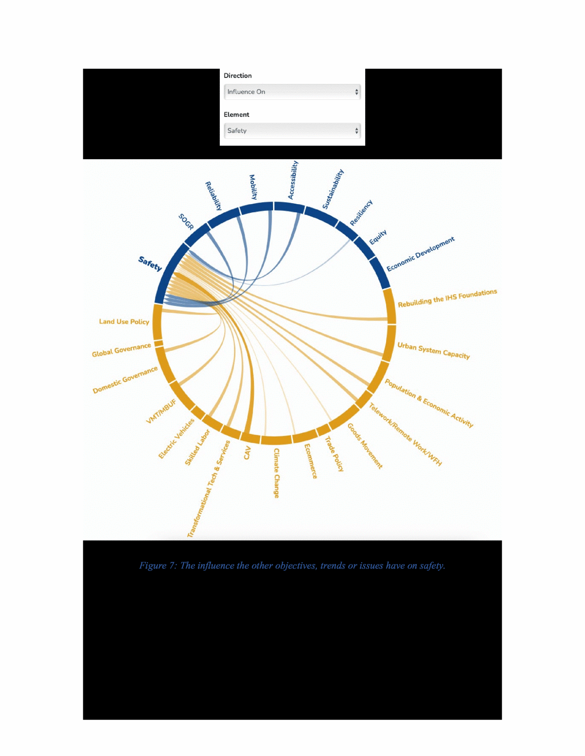
27 SAFETY OBJECTIVE Most state DOTs have embraced an objective of reducing the number of fatalities on their roadways to zero. States may be aligned with the Toward Zero Deaths campaign, the National Safety Councilâs Road to Zero campaign, or the Vision Zero model first implemented in Sweden in the 1990âs. While the organizations and methodologies involved may differ between these campaigns, the objective is the same â zero fatalities. With annual roadway fatalities being persistently in the mid- 30,000s from 2015 to 2019, there is a long way to go to zero, but stating the goal and consistently working toward it is the objective. RELATIONSHIPS TO OTHER OBJECTIVES The arc diagrams below show the relationship of safety to the other objectives, trends, and issues. Figure 7 shows the influence the other objectives, trends or issues have on safety. Figure 8 shows the influence safety has on the other objectives, trends, and issues. As can be seen in figure 7, the state of good repair has a direct and strong relationship to safety, however the sustainability and equity objectives of a system do not influence the safety of the system. From figure 8, safety has no direct relationship to the state of good repair, but it does have a strong relationship to the reliability of the system. Crashes can easily disrupt the operations and reliability of the system. Reducing fatal and serious injury crashes to zero.
28 Figure 7: The influence the other objectives, trends or issues have on safety.
29 Figure 8: The influence safety has on the other objectives, trends, and issues. RELATIONSHIPS TO TRENDS AND ISSUES The CIHS and CIT2019 reports addressed safety as Ensuring Safety While Accommodating a Growing and Changing Vehicle Fleet and Safety and Public Health, respectively. They both noted the need to continue to identify and advance the safest road and vehicle designs and to identify and advance operational and behavioral means to reduce alcohol, drug impaired, distracted and fatigued driving, and speeding. They note the potential that connected and automated vehicles have to alter the operations and safety of the highway system. Many of the technologies are vehicle- centered, such as driving-assist features and automated vehicles, while others are aimed at
30 integrating vehicles and highways through increased connectivity. The trends and issues noted below were identified through the CIHS and CIT2019 reports and this research. Some warrant maintaining a situational awareness of their development so they can be factored into decision- making to support the safety objective and others have potential to directly impact system safety. Connected and Automated Vehicles. The potential of CAVs to improve safety, as well as system objectives like reliability, are well documented in research and literature. The technology and applicability of autonomous and connected vehicles (CAV) continues to advance and become integrated into newer model vehicles. While the timeframe for customer acceptance and the advancement through the five levels of automation is still an open question, the unknown is âwhen the acceptance and advancement will take placeâ not âif it will take place.â The CIHS Report stated it as: âAs the societal acceptance of CAV is unknown at this time, the magnitude and net direction of these VMT impacts is extremely difficult to estimate, as is their timing. A reasonable expectation is that the nationâs highway system will continue to be populated by a mix of vehicles with widely varying levels of automation and human operation for at least the next 20 years.â The work on vehicle automation is working hand in glove with vehicle connectivity â to other vehicles, to the infrastructure, to V2X vehicle to everything. The STAs continue to actively research the impacts of connected vehicles and automated vehicles on state and local transportation agencies through several research projects. NCHRP 20-102 is a $6.5M task order project to (1) identify critical issues associated with connected vehicles and automated vehicles that state and local transportation agencies and AASHTO will face, (2) conduct research to address those issues, and (3) conduct related technology transfer and information exchange activities. An update to research roadmap for NCHRP 20-102 is scheduled for May 2021. In parallel to this work, NCHRP 20-102(28) is preparing Agencies for AVs and CVs in work zones, and NCHRP 20-102(24) is researching infrastructure modifications to improve the operational domain of automated vehicles. Data. Regardless of whether the CAV communications platform is DSRC (Dedicated Short-Range Communications) or the 5th Generation of cellular mobile communications (5G) both CVs and AVs will have the capability to generate and transmit massive amounts of data. Vehicle bandwidths will need to be routinely increased for point-to-point communications and to distributed network structures. Level 5 cars could send 25 gigabytes of data (e.g., route, speed, braking, acceleration, and, potentially, road conditions.) to the cloud every hour.11 This massive amount of data presents a very rich environment that machine learning and artificial intelligence applications could explore. With machine learning and artificial intelligence applications working with that amount of data, driving algorithms or programs for AVs and CVs could constantly be updated, refined and fed back to the vehicles. It also presents a growing opportunity for the transportation community and its research programs to augment existing data sources to improve either the display capacity of system performance measures or to begin to explore predictive and prescriptive (decision) analytic capacity by correlating this data with existing data. Infrastructure (V2I). Alongside this dynamic, the trends and issues in the reports and this research indicate that the condition of current infrastructure will necessitate a major rebuilding of the systemâs foundations and that population growth in the U.S. that is estimated to take place
31 between 2010 and 2060 will be uneven across the country. The indication is there will be more of the population shifting toward metropolitan centers, an increasing urbanization of the country, and that the number of counties, mostly rural, that are projected to experience a population decline is larger than the number of counties forecast to gain population. This population growth and shift will result in changing centers of population and economic activity, which will drive demand for changing the systemâs length and layout and expanding and managing urban system capacity. Within these larger populational shifts are shifts in where people work and e-commerce is changing goods delivery and individual shopping trips as a part of travel demand across the country in both urban and rural communities.12 As noted above, there is substantial research being conducted on integrating CAVs into the system, particularly in researching infrastructure modifications to improve the operational domain of automated vehicles. In that vein, one of the pilot studies conducted for this research project explored Optimizing Strategies for V2I Implementation. This pilot study developed metrics and prescriptive (decision) analytic that can support decisions on where to place V2I infrastructure on the network to maximize its ability to improve multiple objectives. Details on that pilot study can be found in Appendix F of this report. Deployment of Transformational Technologies and Services. The CIT2019 Report noted both Research and Innovation, and Transformational Technologies and Services as issues that need to be taken into consideration. The relationship between these two is straightforward and clearly understood. Research and innovation are precursors to developing and deploying transformational technologies and services and STAâs take full advantage of this relationship by continuing to fund robust research and innovation programs. The report made two points relative to these issues. First, that the public sector is inherently cautious, risk-averse, and hesitant to use new materials or techniques without extensive field testing. The challenge is continuing to support and accelerate the public sectorâs willingness to try innovative techniques and materials. Second, âconsumer preferences and market pressures will play central roles in determining which technologies and services emerge and succeed, but public policies, if exercised, can also play a key role in encouraging and directing their commercialization for the common good.â Governance. The CIT2019 Report clearly identified coordinated governance as a driver to successful system management. It found that âTransportation infrastructure and services are provided at multiple levels of government each of which has a role in planning, funding, and managing some aspect of transportation infrastructure. These systems connect with each other and span jurisdictional lines. Challenges exist in network planning, funding, and management and as metropolitan areas grow into megaregions spanning multiple states successful cross-agency cooperation will be necessary to establish and maintain integrated and efficient networks.â The integration of AVs and CVs into the transportation network and vehicle fleets highlight this issue. There are many programmatic and policy questions that are being posed at every level of government, federal to local, from coordinating where platooned trucks could operate safely to coordinating deployment of V2I assets as noted above. The U.S. DOT has issued multiple policy documents that provide guidance to Federal Agencies, states and local municipalities, and multiple organizations have websites that track the latest developments in policy, research, etc. For example, the National Association of Counties (NACo)
32 has a website titled Connected and Automated Vehicles Tool Kit: A Primer for Counties: that catalogues policy documents from multiple sources.13 The National Conference of State Legislatures (NCSL) maintains a searchable database on autonomous vehicle bills that have been introduced in State legislatures called the Autonomous Vehicles State Bill Tracking Database.14 State and local transportation agencies can use these resources to stay abreast of and, potentially, coordinate legislation and policies that effectively and efficiently advance and deploy CAVs. This could enable these vehicles to maximize their full potential and improve the safety performance of the system. This coordination could extend to sharing data to better understand the dynamics of whatâs occurring on their networks. Skilled Labor on Construction Sites. The continued challenge of placing and retaining skilled labor on construction sites has implications for system safety. The Associated General Contractors of America (AGC) conducts an Outlook Survey that asks the question âWhat challenges, if any, do you see regarding the safety and health of your firmâs workers?â The results of that survey report that inexperienced skilled labor/workforce shortages consistently rank as the highest concern in response to this question. This challenge consistently ranks higher than safety hazards created by third parties which include inter alia motorist crashes into work zones and nonemployees potentially spreading coronavirus on the jobsite. MEASURES In 2012, MAP-21 enacted safety performance measures. In 2016, the Federal Highway Administration (FHWA) issued the Final Rule on safety performance measures establishing five performance measures to be reported to the Highway Safety Improvement Program (HSIP): Number of fatalities; rate of fatalities per 100 million VMT; number of serious injuries; rate of serious injuries per 100 million VMT; and number of non-motorized fatalities and non-motorized serious injuries. Three of the measures (number of fatalities, rate of fatalities and number of serious injuries) are identical to safety performance measures required by the National Highway Traffic Safety Administration's (NHTSA) State Highway Safety Plan (HSP). The Final Rule required that States report general highway safety trends, safety performance targets, and discussion of differences between targets and outcomes. Agencies are beginning to diversify the safety measures they monitor. As urban freight increases and the patterns of parcel delivery shift to more urban and residential areas, DOTs are starting to consider how freight vehicles are interacting with vulnerable road users. In that vein, there has been a marked shift towards considering a more comprehensive set of road users in safety performance measurement. Non-motorized modes are increasingly more often measured, as well as less severe crashes. Specifically, transportation agencies have traditionally been concerned with passenger vehicle safety, as this mode constitutes a preeminent role in system-wide mode share. However, as planners and policy makers transition away from automobile-centric models of transportation planning in the era of climate change resilience, safety of active modes of transportation is becoming increasingly important. According to FHWA, data-driven performance management is a five step, iterative process, culminating in âadjusting strategies, as needed.â This is the precise stage in which safety regulators find themselves today. Improvements in data collection and monitoring technologies allow regulators to consider a host of factors that were previously unmeasurable. This improved capacity will allow agencies to maintain more
33 comprehensive and nuanced data that will inform better decisions and help create a safer transportation system for all users. Many automobile manufacturers are now including systems that monitor a vehicleâs functions in the vehicles they are currently selling. These vehicles transmit data on speeds, locations and driving parameters (e.g., hard braking, rapid acceleration) to the vehicle manufacturers.15 Going forward, the volume of vehicular data these vehicles could generate, when combined with roadway characteristics and existing crash data could provide for a much fuller safety analysis. An example of how this data could be combined is being advanced by Ford Motor Company at their Safety Insights website https://safetyinsights.ford.com/#/ . Safety Data Initiative (SDI) The U.S. Department of Transportation (DOT)âs Safety Data Initiative (SDI) program seeks to use data-informed decisions to identify safety challenges and solutions that can mitigate them such as: ⢠Data Integration: Integrate existing DOT databases with new âbig dataâ sources. ⢠Predictive Insights: Use data analytics techniques to identify risk pattens and develop insights that can help develop mitigation strategies. ⢠Data Visualization: Create data visualizations to help policy makers arrive at safety solutions. Ongoing pilot studies under SDI are: ⢠Waze Pilot: DOTâs Volpe National Transportation Systems Center (the Volpe Center) is leading a pilot project to estimate police-reported traffic crashes by combining crowdsourced crash data from Waze with crash data in near-real time. It employed machine learning techniques with these datasets to train statistical models to predict crashes. ⢠Rural Speed Pilot: It is an ongoing study to understand the role of prevailing speed, speed limit, and average travel speed on severity of crashes on rural highways. The speed data is used from National Performance Management Research Data Set (NPMRDS) that provides prevailing speeds at 5-minute intervals across the entire National Highway System. ⢠Fatality Analysis Reporting System (FARS) Data Visualizations: NHTSA is enhancing the presentation of FARS data, by developing interactive visualizations of their Traffic Safety Fact Sheets using Tableau visualization software. In June 2020, U.S. DOT announced almost $3.3M in awards and selected nine state, local, and tribal governments to apply new data integration and analysis techniques, test new tools, and share lessons learned and best practices to advance transportation safety practice as a part of SDI. The agencies selected and their projects are: ⢠The City of New Orleans in Louisiana: To refine and expand USDOTâs existing Pedestrian Fatality Risk Map to include risk to bicyclists. ⢠The Confederated Tribes and Bands of the Yakama Nation Department of Natural Resources in Washington State: To build on an existing roadway data analysis tool developed by the University of Washingtonâs STAR Lab and develop a comprehensive roadway safety data visualization and evaluation platform.
34 ⢠Connecticut Department of Transportation: To develop a tool to improve the Stateâs behavioral safety decision-making by integrating crash and roadway information with data on citations, toxicology, and hospital injury data. ⢠Maryland Department of Transportation State Highway Administration: To develop and implement a data analytics and visualization dashboard using mobile device location data and electric scooter trip data. ⢠Massachusetts Department of Transportation: To expand an existing crash data portal to help regional transportation planners and law enforcement identify higher risk roadways. ⢠MetroPlan Orlando: To build upon the University of Central Floridaâs (UCF) safety data visualization tool. ⢠North Carolina Department of Transportation: To develop an AI tool for automated analysis of existing video log data that would extract roadside hazards. ⢠Regional Transportation Commission of Washoe County: To extract road geometric features from (LiDAR) and use AI to create a dataset that would be incorporated into GIS software for roadway safety analysis. ⢠Virginia Department of Transportation: To develop a safety analysis tool, which would identify and visualize locations with higher levels of risk that would benefit from low-cost safety countermeasures. Non-motorized Mobility and Safety Ohio DOT developed a comprehensive set of active transportation performance measures. In the context of their Walk.Bike.Ohio.Plan (WBOP).16 In this plan, the state outlined a comprehensive set of performance measures to accompany their goals of equity, network utilization, network connectivity, safety, livability, and preservation. Notable performance targets include 40% of spending on bicycle and pedestrian projects going to disadvantaged communities, .25% annual increase in walking to work, .5% increase in proportion of low-stress bike routes, 2% annual reduction in non-motorized fatalities, and 90% of sidewalks rated in good condition. Another relevant measure is Transport for London (TfL) which is measuring mode share where cycling is measured in daily kilometers cycled toward a target of 80% of trips in London will be made by active, efficient and sustainable modes by 2041. TfL also developed a Healthy Streets check for designers that could be explored.
35 STATE OF GOOD REPAIR OBJECTIVE To maintain capital assets in a condition sufficient for the assets to operate at a full level of performance. This involves repairing or replacing assets as appropriate and performing preventative maintenance to maximize the useful life of the assets. RELATIONSHIPS TO OTHER OBJECTIVES The arc diagrams below show the relationship of state of good repair to the other objectives, trends, and issues. Figure 9 shows the influence the other objectives, trends or issues have on the state of good repair. Figure 10 shows the influence the state of good repair has on the other objectives, trends, and issues. As can be seen in the figure 9, the state of good repair is most strongly influenced by the economic development objective; more economic activity typically means more travel. Figure 10 shows the state of good repair has the strongest influence on the objectives of reliability, mobility, and resiliency, but also has medium influence on safety, accessibility, and economic development. Maintaining capital assets in a condition sufficient for them to operate at a full level of performance.
36 Figure 9: The influence the other objectives, trends or issues have on the state of good repair.
37 Figure 10: The influence the state of good repair has on the other objectives, trends and issues. RELATIONSHIPS TO TRENDS AND ISSUES Rebuilding the System Foundations. A complete rebuilding of the foundations of the original Interstate Highway System (IHS) would have a significant positive influence on the State of Good Repair, by renewing the underlying structure on which other investments depend. Preservation can only go so far in extending the useful life of capital assets, and as of 2019, more than one-third of IHS bridges have been in service for more than 50 years. Set against such an ambitious investment
38 program is the shear mass of the stock of roads, over 227,000 lane miles along 46,000 centerline miles.17 Even recently built sections from the 70âs and 80âs will require rebuilding in coming decades. Research suggests that âthe U.S. Interstate system has a persistent and growing backlog of physical and operational deficiencies as a result of age, heavy use and deferred reinvestment, and is in need of major reconstruction and modernizationâ18. Research concludes that annual investment would need to more than double over the next 20 years to overcome this backlog.19 Yet without substantial investment, the IHS will become like a house with a broken foundation; always capable of being repaired, but never of being fixed, and always at risk for sudden collapse. Goods movement. As Critical Issues in Transportation 2019 noted, goods movement is essential to the U.S. economy. Americaâs distribution network for goods encompasses coastal ports that onload and offload goods to or from inland intermodal exchange facilities. These exchange facilities provide value-added services like load consolidation, warehousing, packing, sorting, assemblage or finishing, then forward the goods to distribution centers and on to point of sale locations. They include border ports-of-entry and the airports that handle air cargo. The variety, size and placement of these nodes on the network provide shippers (the cargo owners) and carriers (the modes on which the cargo moves) the needed bandwidth to efficiently and effectively manage consumer demands and to diversify their operations. The 2018 BTS Freight Facts and Figures Report showed that trucks moved 61% of the total tonnage of goods moved in the U.S.; that the largest percentage of goods, by weight and value, move distances of less than 250 miles; and trucks carry the largest shares by value, tons, and ton- miles for shipments moved less than 1,000 miles. Truck freight competes with air-cargo (at the high end) and with railroads (on the low end) and truck freight faces increasing competition from rail. Until relatively recently, truck freight was preferred for distances under 500 miles, but rail improvements (double-stacking, port integration, better scheduling, increasing number of intermodal centers) and increased urban roadway congestion have made rail increasingly competitive for shorter distances.20 Changes in the modal mix and trends in goods movement will significantly influence state of good repair because most road damage caused by vehicles is caused by trucks. Climate Change. Extreme temperatures, extreme precipitation, flooding both coastal and from rivers, etc. damage roadways and bridges. Due to climate change, extreme conditions are predicted to become much more common, which indicates that climate-induced damage to the roadway system will also become more frequent and more severe. Currently, road maintenance costs vary widely by state, with states with less temperate climate conditions spending more on maintenance.21 Climate change induced weather events will likely have more costly impacts on the state of good repair because the conditions created will be outside the design maxima of existing infrastructure. Examples include flooding in Detroit due to extreme precipitation events, asphalt buckling during extreme heat events in the Pacific Northwest, and Category 5 hurricanes in Florida.22 Different climates have different numbers of freeze-thaw cycles and extremely hot days, both of which induce road deterioration. Extreme precipitation events and associated flooding can also damage pavements.23 Climate change will accelerate the deterioration of IHS assets, increase operational disruptions, and cause catastrophic failure of some structures. Skilled Labor on Construction Sites. The construction industry continues to face significant challenges in placing and retaining skilled labor on job sites, a challenge they have faced for more
39 than two decades. A 1997 study from the National Center for Construction Education and Research (NCCER) found that 92% of construction firms responding to a national survey reported shortages of skilled labor. More than 85% of those surveyed said their current workforce was not as skilled as it should be in that market. A year earlier, in 1996, the Business Roundtable surveyed a similar group of businesses and found that 75% of respondents reported an increase in shortages of skilled labor over the previous five years (The Business Roundtable, 1998). In studies conducted in 2020 by the National Association of Business Economics, 2021 by the U.S. Chamber of Commerce and by the Associated General Contractors of America (AGC) from 2013-2020, this challenge persists. The U.S. Department of Labor has initiated a nationwide effort to rebuild the pipeline of education, training, and on-the-job experience necessary to meet this challenge. Many states have established apprenticeship programs that reflect and support this goal. Efforts include partnering with community colleges to deliver education and training and with industry to provide on-the-job opportunities. Engagement with and support for these efforts by state and municipal transportation agencies can help promote the skilled trade workforce needed to maintain the transportation system in a state of good repair. Vehicle-Miles-Traveled / Mileage-Based-User Fee (VMT/MBUF). Construction of the Interstate Highway System and the National Highway System were built using revenue from motor vehicle fuel taxes and later surface transportation acts funded system reconstruction and repair. While inflation has periodically made it necessary to raise the headline fuel tax rate, the fuel tax has been a reliable and uncontroversial source of funding for the surface transportation. In recent years, improving vehicle mileage has damaged this link, and widespread vehicle electrification threatens to destroy it altogether. Yet without a steady, reliable source of funding for maintenance the state of good repair will inevitably decline. Hence, action to implement the capacity to enact and exact VMT/MBUF will have significant impacts on transportation funding. The option of instituting a VMT fee or a MBUF is attractive in that it is a means for collecting revenue with options for adjusting fees by type of fuel, vehicle size/weight, road system, and time of travel. By adjusting this fee, federal, state, or local governments could implement fees that would send economic signals regarding fuel type and road usage that would, in turn, influence current system performance measures. Mileage based fees become an opportunity to influence system performance in addition to being a funding source to maintain a state of good repair. Thus, various national studies and research efforts have recommended implementation of MBUFs, such as the National Surface Transportation Infrastructure Financing Commission created by the transportation reauthorization legislation SAFETEA-LU. There are several implementation issues to resolve in establishing MBUFs, in addition to significant political resistance from those who consider user fees to be a form of taxation. Governance. The CIT2019 Report clearly identified coordinated governance as a driver to successful system management. It found that âTransportation infrastructure and services are provided at multiple levels of government each of which has a role in planning, funding, and managing some aspect of transportation infrastructure. These systems connect with each other and span jurisdictional lines. Challenges exist in network planning, funding, and management and as metropolitan areas
40 grow into megaregions spanning multiple states successful cross-agency cooperation will be necessary to establish and maintain integrated and efficient networks.â With interconnected systems managed by multiple jurisdictions, coordinating asset management plans to ensure system upgrades or rebuilding are coordinated and complementary will influence the state of good repair of these systems. This is compounded by the cost of system maintenance. Durable capital investments are expensive. Building and maintaining a transportation network requires ongoing sustained investment. Deferred maintenance not only accumulates but also compounds and failure to engage in preventative maintenance can significantly shorten asset life. Consequently, consistent, coordinated commitment is necessary to maintain the state of good repair and preserve existing system assets. Land Use Policy. Governments at all levels manage the development and use of land within their jurisdictions. The process of allocating and regulating land use takes into consideration social and environmental outcomes and the efficient use of resources. The American Planning Association states that the goal of land use planning is to further the welfare of people and their communities by creating convenient, equitable, healthful, efficient, and attractive environments for present and future generations. Transportation and land use are tightly intertwined and, in many ways, form a feedback loop between them. How land is used, zoned, or regulated affects the activity between and among different land uses. Access between different land uses is shaped by the availability and capacity of the transportation infrastructure that connects and serves them. The access transportation systems provide to different land uses can influence activity patterns in terms of their distribution and level of transportation demand and can influence economic and demographic changes. Increased demand on the transportation system will, in turn, shape the planning, maintenance and upgrade of the transportation connections. Increased or expanded accessibility can then precipitate another round or cycle of interaction between these two dynamics. Given this tight interconnectivity, governmental policies regarding how land is used, zoned, and regulated and the accessibility, reliability, and mobility options of the transportation systems that serve those land uses can significantly influence economic development patterns. Research on travel behavior has reliably demonstrated that density, land-use diversity, and design characteristics influence travel behavior.24 The extent to which local land use policy permits high- density development, mixed-use, and a gridded street network is a strong determiner of non- automobile travel, and hence the demand for vehicular capacity, which, in turn, determines the stock of roadway lane miles which require maintenance. Development density has a secondary effect, regarding the taxable land value available for assessment per lane mile. Rural highways have always required subsidy, and single-family detached suburbs are broadly recognized as being fiscally unsustainable without subsidy from associated commercial development. Over the long- term, many suburbs are facing a financial crisis when confronted with the need to replace/reconstruct essential infrastructure rather than merely maintain it. Higher density development has a better ratio of (taxable) assets to liabilities. Expanding & Managing Urban System Capacity & Changing Centers of Population and Economic Activity. In conjunction with the rebuilding function above, these two issues will need to factor in which assets undergo complete rebuilding and where. The extent to which urban areas
41 attempt to solve congestion problems through additional roadway capacity will affect the stock of roadway lane miles. Alternately, if travel demand management policies (congestion pricing, telework, transit systems) are pursued, the maintenance obligations incurred due to an increase in system lane miles can be mitigated. The degree to which state transportation agencies work to âRight-Sizeâ existing transportation facilities in response to these two issues to better match demand will affect what is rebuilt and where.25 Transformational Technologies/Services. Of the technologies/services identified in the CIT2019 report, improvements in sensor technology and AI-assisted image categorization offer the potential of standardizing and automating the process of pavement survey, and partially automating the associated predictive analytics regarding what elements of the system will benefit the most from which preservation treatments.26 For bridges and structures, drone aircraft and image recognition offer the potential to revolutionize data collection and analysis of bridge condition, by providing the capacity to linger and review for parts of bridge dangerous for humans to access. Recorded images are also amenable to further review and analysis through AI-assisted pattern recognition. Additionally, the third phase of NCHRP Project 20-126 (03) conducted a critical review of current and leading practices, research and application of emerging and new technologies, and opportunities for further advances that identified near-term opportunities for improving agenciesâ capabilities to assess and monitor the foundational integrity, condition, and service capability of highway system assets. Traditional infrastructure design depended on 2-dimensional (2D) technical drawings (e.g., plans, elevations, sections). Since the release of AutoCAD in the early 1980âs, the transition of 2-D plans to 3-dimensional (3D) computer/digital renderings has progressed considerably. This technology and group of processes when used in the building or vertical construction trade is referred to as Building Information Modeling (BIM) and has been in use in building construction and asset management for many years. The use of this method of collecting, organizing, and managing accessibility to the data and information related to highway facilities emerged in the highway industry in the last decade. In the highway industry this concept is called Civil Integrated Management (CIM). BIM or CIM enables a broad range of collaborative processes relating to the built asset from initial planning, through construction, and throughout its operational life. Starting at the planning phase, this concept enables the virtual construction of a facility in 3-D. Operating in a collaborative, shared environment this process reduces uncertainty and enables collaborators to identify and work out problems. For example, it can be readily noted in the model where structural components may be misaligned and it enables the team to analyze the potential impacts of different solutions. Once created in an electronic or digital form, quantities, and specifics on the properties of materials can be easily extracted and systems, assemblies and construction sequences can be shown in a relative scale with the entire facility or group of facilities. The adoption of CIM/BIM by an organization opens doors to more efficient and effective collaboration, risk management, construction efficiencies, asset management and life-cycle costs. It also necessitates more involvement and understanding of data management, data governance, cybersecurity and a broad range of skill sets to manage and utilize this capacity.
42 Lastly, there are a steady stream of market ready construction techniques and contracting innovations that are routinely being advanced. Construction Manager/General Contractor (CM/GC), Design-Build all the way to Design-Build-Finance-Operate-Maintain, and Bridge Bundling are contracting options. Construction techniques include prefabricated bridge elements and systems (PBES), accelerated bridge construction (ABC), intelligent compaction, collaborative hydraulics, ultra-high performance concrete (UHPC) for bridge preservation and repair and targeted overlay pavement solutions are but a few of the construction innovations that are proven to save time and funds as well as deliver exceptional value. The utilization of these options as they become available can make a difference in the state of good repair. The absorption and deployment of emerging technologies was the focus of Volume Three of the NCHRP 750 Report Series: Expediting Future Technologies for Enhancing Transportation System Performance.27 The objective of this project was to develop a process that transportation agencies can use to identify, assess, and adopt new and emerging technologies to achieve long-term system performance objectives. The research team developed a process called STREAM - Systematic Technology Reconnaissance, Evaluation, and Adoption Methodology, to evaluate technologies considering their effects on agency goals as well as barriers in implementation. The focus of the report is on the evaluation of emerging technologies and practices. The need for this process was clearly noted in Volume Seven of the NCHRP 750 Report Series: Preservation, Maintenance and Renewal of Highway Infrastructure.28 This report has direct relevance to this objective and describes a number of future scenarios that STA leaders and practitioners should consider and notes that regardless of which scenario unfolds, âagency leaders should foster emerging and innovative PMR29 practices that have the potential for achieving performance targets in a more cost-effective manner.â And âPMR practitioners must find ways to sustain ongoing awareness of emerging and innovative PMR practices by initiating periodic, strategic planning exercises to understand the context changes to PMR needs and emerging practices, and plan ahead to maximize efficiencies.â Trade Policy. At a more macro level, the World Economic Forumâs 2020 Global Risks Report noted that the fundamentals of a more open trading environment are being questioned as nationâs pursue more individualistic approaches.30 Regardless of whether free trade or protectionist policies are pursued, there are implications for the transportation network and for goods movement in either direction. This was a key finding in NCHRP Report 750 â Strategic Issues Facing Transportation: Scenario Planning for Freight Transportation Infrastructure Investment.31 There were two key drivers for what would influence goods movement to/from and within the U.S.; the resource availability of fuel and global trade policies. Given the importance of goods movement to the U.S. economy and its impact on the transportation network, how this trend plays itself out will impact where on the system the state of good repair will be most affected due to goods movement patterns. MEASURES In 2012, The Moving Ahead for Progress in the 21st Century Act (MAP-21) created a performance-based surface transportation program and instituted an explicit set of NHS Pavement and Bridge Condition performance measures, including guidance on asset management. Transportation Asset Management Plans (TAMP) were required along with increased reporting requirements of condition by asset category.
43 The current federal performance measures for pavement are based on the share of pavements in âgoodâ or âpoorâ condition (with an accompanying index for calculating what represents those conditions) for two classes of roads (Interstate and Non-Interstate), over two time periods (so as to assess trends), for a total of 8 measures. Performance Target Interstate Condition (Lane-miles) Non-Interstate Condition (Lane-miles) Two-year % Good % Good % Poor % Poor Four-year % Good % Good % Poor % Poor The current federal bridge performance measure breaks the rating down by three bridge elements (substructure, super-structure, deck), rates each, and takes the lowest value of the three weights. The scores are converted to categories (good, fair, poor). The share of bridges in each category are weighted by area (bridged length & width) and summed to determine the share in each category. After a baseline is established, targets are then established. Failure to achieve progress toward targets for two reporting periods (4 years) requires documenting actions state DOTs will take toward achieving those targets.32 Culverts have their own metric. In the last two decades, data collection techniques have evolved from manual and semi-automatic to fully automatic to help improve the integrity of the data that serve these measures. The techniques include data collection by automated mobile applications on a transportation vehicle or by satellites and aircrafts. A few examples of measuring equipment used are GPS, Inertial Navigation Unit (INU), Video Logging and Laser. Drone aircraft and image recognition offer the potential to revolutionize pavement management. Drones offer the potential to substantially reduce data acquisition costs, and the potential to automate pavement classification, thereby opening the door for much better spatial resolution. Combined, this provides the capacity for pavement management systems that are both more comprehensive and more current. Drone aircraft are already being used for surveying purposes by power line companies and agricultural users. Current FAA regulations limit their operations to line of sight operations, but the hurdle is regulatory rather than technological. Both drone and image recognition technologies are bolstered by the improving quality of light detection and radar (LIDAR) and 3D image storage and management. This would involve a range of data management, data storage, etc. but would be fully compatible with the emerging trend toward a digitized environment of plans, current conditions and asset management represented by building information management (BIM) or civil integrated management (CIM). Bridge conditions can be difficult to assess, as component parts are either hidden, such as rebar within concrete, or difficult to access because they are elevated, underground, or underwater. Non-
44 destructive testing is not definitive and destructive testing (cores) damages structures.33 Technology advancements enable embedded sensors to assess and monitor the foundational integrity, condition and service capability of highway system assets. Substantial research is underway to identify and develop efficient and cost-effective non-destructive testing through in situ inference and direct measurement of the foundational integrity, condition, and service capability of highway system assets.34 Additionally, NCHRP Project 20-126(03) conducted a critical review of current and leading practices, research and application of emerging and new technologies, and opportunities for further advances that identified near-term opportunities for improving agenciesâ capabilities to assess and monitor the foundational integrity, condition and service capability of highway system assets. Drone aircraft and image recognition offer the potential to revolutionize data collection and the analysis of bridge conditions. They offer the ability to access parts of bridges dangerous for humans to access, and provide an improved ability to linger and review, including recording observations for further review. The digitized information and recording provide a reference for further analysis and could become part of a bridge assetâs file in an asset management system that migrated to a CIM platform. Drone underwater craft offer much the same advantage for underwater inspections as drone aircraft.
45 ECONOMIC DEVELOPMENT OBJECTIVE The principal economic objective of transportation infrastructure is to offer efficient movement of people and goods at a competitive cost. There are four principal ways transportation choices can achieve an economic objective. Direct Stimulus: Transportation choices can stimulate the economy through direct spending on transportation infrastructure and services, Transportation Efficiency: transportation choices can resolve inefficiencies in the movement of people and goods, enabling households and businesses to apply savings in other areas, Market Access: Transportation choices can make a wider pool of labor, consumers and suppliers available to firms enabling them to produce more output per dollar of input, and Business Attraction: Transportation choices can make sites available that may attract businesses to new or more efficient locations â affecting the composition of local/regional economies. While the direct stimulus and transportation efficiency pathways to economic development can often be identified through monetizing transportation benefits and assigning those benefits to different stakeholders (households, shippers and carriers), the other pathways can be more complex.35 For example, a bridge expanding the number of engineers within commuting distance of a high-technology research center may not solve any quantifiable mobility, safety or environmental deficiency, yet can greatly enhance the dollars of output available to firms in the district per dollar of outlay. Such an example would be a market access improvement which may not show up in any other performance indicators. Through the Strategic Highway Research Program (SHRP2) EconWorks system (accessible from AASHTO), widely available methods are in practice to quantify market access outcomes.36 Furthermore, when a transportation performance objective explicitly relates to business attraction, questions arise regarding (1) whether the business location decision can truly be attributed to a transportation infrastructure choice, (2) whether the value of the new business location is actually more beneficial to society than a prior location and (3) how the value of the infrastructure in supporting a business location decision can be weighted relative to other transportation performance criteria. In 2018 the FHWA provided a primer on this subject, which includes fact sheets to guide these determinations.37 The achievement of this objective is generally assessed using a combination of economic impact models which derive the economic activity associated with direct transportation spending, permanent household/business cost savings, market access productivity gains and local business attraction. Because the economic impacts of transportation choices occur over a long period of time in an open system (where transportation choices are only one of many factors accounting for a change in economic conditions), it is very difficult to empirically measure such outcomes. While changes in earnings, employment, business output and GDP can be reasonably derived through modeling techniques, the changes can never be fully isolated to the role of infrastructure the way The transportation systemâs capacity to improve access to markets, employment, and resources at reasonable cost.
46 that reductions in crashes, delay or emissions can. Ex-post evaluation of economic outcomes can take a very long time and is beyond the resources of most agencies. The challenge is that while these relationships can be quantified, the relationships do not lend themselves to direct measures but require a more complex framework as described above. That said, there are multiple guidebooks and resources to help assess the economic effects of transportation projects.38 A study conducted by the New Zealand Ministry of Transport on Contribution of Transport to Economic Development found that in a built environment with transportation investments having to meet multiple objectives, such as preservation, safety, reliability, accessibility, or equity, an increased proportion of investment may be allocated for infrastructure and services that address multiple objectives rather than solely economic development.39 This report supports what the National Research Council noted as it goes on to state that within a city or urban environment, transportation benefits can extend beyond the initial benefits of improvements in key objectives or performance measures like reliability, safety or equity to provide positive impacts on economic growth and development. Changes to the availability and affordability of mode choice for example, walking, biking, or transit can influence and shape the accessibility to resources within an area. Transportation investments that influence the livability or desirability of an urban environment could improve, or not, its appeal as a place to live, work or visit which would, in turn, influence the economic vitality of an area. The New Zealand Study also found that âBeyond the initial effects of transport investment on journey times and costs, labour market, agglomeration and transport, network effects also influence the long-term impacts of transport investment on economic growth and urban/regional development.â It found that many of these economic impacts play out via land use changes and that the wider economic impacts are usually in addition to the benefits of reduced travel times, emissions reductions or improved safety that would routinely be evaluated as part of a transportation projectâs assessment. Lastly, the report noted that transportation investments can have multiple effects on the economy of an area or region, such as the locations of residences and industries, land values, growth patterns or travel demand. While these impacts were more widespread in developing countries that are establishing a transportation network, it found that: âWhere there is already a well-connected transportation infrastructure network of a high quality, further investment in that infrastructure will not, on its own, result in economic growth. However, where the potential for economic growth is present and there are capacity constraints, a lack of transportation investment can inhibit potential growth. Investment in these circumstances should focus on responding to demand and âpinch pointsâ [e.g., âbottlenecksâ, âinadequate intermodal connectorsâ or âinsufficient intermodal interchange facilitiesâ] which would otherwise constrain growth. The impact of improved transport links on regional economies is context-specific and must be assessed on a case- by-case basis. [emphasis added]â As noted in the sections on mobility, accessibility, and equity there are strong interdependent relationships between these objectives and economic development. A transportation systemâs capacity to provide access to all stakeholders to a broad range of goods and services, facilitates
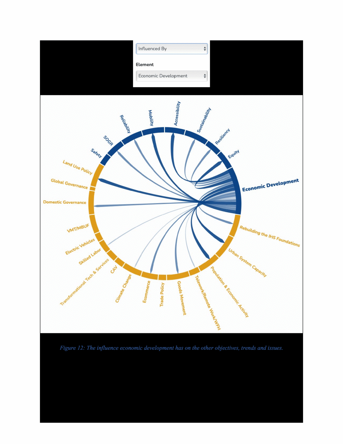
47 and enables economic activity. To the extent that the access is multimodal, including active transportation, it enhances the systemâs mobility and to the extent that the access is affordable and evenly distributes costs and benefits, it embraces an equitable system. RELATIONSHIPS TO OTHER OBJECTIVES The arc diagrams below show the relationship of economic development to the other objectives, trends, and issues. Figure 11 shows the influence the other objectives, trends or issues have on economic development. Figure 12 shows the influence economic development has on the other objectives, trends, and issues. As can be seen in figure 11, several of the other objectives, such as resiliency, mobility, reliability and accessibility have strong relationships to economic development, almost every objective influences how the system supports economic activity and development. From figure 12 it can be seen that economic development has no direct relationship to safety, but it does have a strong relationship to most of the other system objectives.
48 Figure 11: The influence the other objectives, trends or issues have on economic development.
49 Figure 12: The influence economic development has on the other objectives, trends and issues. RELATIONSHIPS TO TRENDS AND ISSUES Expanding & Managing Urban System Capacity & Changing Centers of Population and Economic Activity One of the foundational reports driving this research, âRenewing the National Commitment to the Interstate Highway System: A Foundation for the Future (CIHS)â identifies
50 two demographic trends / population shifts that will place demands on transportation agencies and influence economic development opportunities.40 Population migration south and west. Based on projected population growth to 2060 from 2010 census data and forecasts, the CIHSâs projections indicate that populations will continue to grow the most in areas currently served by or connected to the Interstate System. However, the projections also point to growing counties that do not currently have nearby (within 50 miles) access to an Interstate highway. In 2019, because of southern and westward population shifts that have been taking place for decades, more than 37 urbanized areas with populations exceeding 50,000 lack nearby access to Interstate highways. The report also found that the number of counties that are projected to experience a population decline is larger than the number of counties forecast to gain population and that most of the counties that will see a decline are rural counties. Urbanization. In 2019, more than 250 million people out of the nationâs total population of 325 million lived in metropolitan regions, and the largest 75 regions â each having more than 500,000 people - account for roughly half the U.S. population. Federal Highway Administration (FHWA) data indicate that 49 of the top 50 truck bottlenecks in the country are located at Interstate interchanges in metropolitan areas. This highlights the challenges of expanding and managing urban system capacity and connects to the finding of the New Zealand Study noted earlier regarding context-specific improvements to improve economic development. Both trends indicate that the population is trending more toward an urban environment. The established metropolitan areas will continue to grow, and mid-sized urban areas are developing in the southern and western regions of the country as the population shifts in those two directions. Rebuilding the System Foundations. Alongside the demands that these population shifts will place on transportation agencies, the CIHS clearly notes that rebuilding the Interstate Highway Systemâs foundations had reached a critical phase and was now imperative. The CIHS also notes that most segments of the Interstate Highway System (IHS) retain their original underlying structure and are past due for a complete rebuild. The newer segments of the IHS, built in the 70âs and 80âs, will need to be rebuilt in the next 20 years (between 2020 and 2040). If the entire 49,000- mile system is to be rebuilt over this period, an average of more than 2,400 miles will need to be rebuilt each year. In 2019, more than one-third of IHS bridges have been in service for more than 50 years and they too will need to be addressed. Work from Home / Remote Work / Telework. Teleworking, remote working or working from home (WFH) is not new. In 2012, Gallup data showed 39% of employees spent some of their time working remotely, which was defined as working away from their coworkers. In 2016, that number had grown to 43%. During the COVID-19 pandemic, however, WFH greatly accelerated. By May 2020, per the Stanford Institute for Economic Policy Research, 42% of U.S. workers were working full-time from home accounting for more than two thirds of the nationâs economic activity.41 Consistent with the types of work that lend themselves to WFH, the overwhelming share of employees who shifted to telecommuting previously worked in offices in urban areas. Almost a year later, between 2/24/2021 and 3/8/2021, the Partnership for New York City surveyed NYC employers. A key finding of that report is that 22% of employers will ultimately require employees to return to the office full-time, 66% will implement a hybrid model with some days in the office and some days working from home, and 9% will not require employees to return42. Workers
51 continuing to WFH means less commuting into city centers and less spending on a range of services including dining, shopping, and entertainment near where they work. A University of Chicago study found that a shift to WFH of even 20% of work hours for occupations that can make this shift will have direct economic consequences for major city centers by lowering sales tax revenue for cities that had high rates of inward commuting before the pandemic.43 A Pew Research Center survey also found that workersâ ability to do their job from home varies considerably by industry. Majorities in the information and technology sector (84%); banking, finance, accounting, real estate, or insurance (84%); education (59%); and professional, scientific, and technical services (59%) say their job can mostly be done from home.44 Among those in government, public administration, or the military, 46% say their job can be done from home. In turn, 84% of those employed in retail, trade, or transportation; 78% in manufacturing, mining, construction, agriculture, forestry, fishing and hunting; and 77% in hospitality, service, arts, entertainment, and recreation say that, for the most part, the responsibilities of their job cannot be done from home. 66% of those in the health care and social assistance sector say the same. While these dynamics have yet to fully play out, WFH could impact the growth the largest U.S. cities have seen since the 1980s as younger, educated Americans began moving into revitalized downtowns. There are already indications that urban residences have become cheaper relative to suburban ones since the pandemic struck, as workers have taken advantage of access to the larger and more elastic housing stock at the periphery of cities.45 WFH may have already begun to shift the dynamics around urban living, shifts that may persist as employers continue to enable remote working practices. The increasing numbers of employees engaging in WFH is already being felt in home purchases. Robin Kencel, an associate broker with Compass in Greenwich, Connecticut note âThe importance of home offices has almost begun to rival the attention that buyers give to kitchens.â and âWhere they will work is on nearly every buyerâs mind.â46 Further, given the depth and length of the social and economic impact the COVID-19 pandemic has had on the nationâs collective conscience, it could well be that even with vaccinations and herd immunity, concerns for the future likelihood of this type of threat will not subside. When COVID- 19 and its continuing mutations and growing evidence of long COVID implications are considered with other epidemics that have taken place within a relatively short time frame (SARS (2002), Swine Flu (2009), MERS (2012), Ebola (2013) and Zika (2015)) individuals and firms may well integrate flexibility in work schedules and social distancing into future workplace considerations. âPeople are looking for more flexibility and more options, which improves their quality of life. Thatâs definitely a legacy of the pandemic.â says Kathryn Wylde, president of the Partnership for New York City, an influential local business group.47 Some employees returning to physical worksites have found those sites to have undergone changes to promote social distancing and other safety measures. A Price Waterhouse and Coopers & Lybrand (PWC) CEO Panel Survey conducted June through July 2020 found the ability to create a safe workplace can be a differentiator, in terms of both the employee and customer experience. Employers who focus on safety will build loyalty and enhance their organizationâs reputation. More than half (61%) of CEOs in the PWC survey believe that the shift towards low-density workplaces will persist48.
52 If this desire for distancing is also applied to mass transit, those systems will be challenged to move large volumes of workers in and out of city centers and that could present real challenges for these systems. While the numbers vary around the country, throughout 2020 major subway systems in New York, Chicago, Washington DC, and San Francisco saw precipitous declines in ridership. In the second quarter of 2020 ridership was down, on average, 76% across the country from the same quarter in 2019. The NYC subway reached a low of 7% of its normal ridership (400,000 of the subwayâs usual 5.5 million daily riders) in the Spring of 2020 and a year later is celebrating a return to a third of the usual ridership, but ridership levels are still a long way from where they need to be to maintain pre-COVID routes, schedules and the economic viability of these systems.49 If lasting transit adjustments in route and schedule take place it could challenge efforts to retain, much less expand system mobility by providing modal choices, impact the reliability of other systems due to reduced commute options, and may well become problematic for essential workers in lower income groups to get to and from work confounding efforts to provide an equitable system. Goods movement. As CIT2019 notes, goods movement is essential to the U.S. economy. Americaâs distribution network for goods encompasses coastal ports that onload and offload goods to inland intermodal exchange facilities that provide value-added services like load consolidation, warehousing, packing, sorting, assemblage, or finishing, to distribution centers to point of sale locations. They include border ports-of-entry and the airports that handle air cargo. The variety, size and placement of these nodes on the network provide shippers (the cargo owners) and carriers (the modes on which the cargo moves) the needed bandwidth to efficiently and effectively manage consumer demands and to diversify their operations. Space constraints at coastal ports and the distribution network of large retailers and manufacturers significantly advanced the growth of inland intermodal exchange facilities to manage, store, and inventory products before being distributed to consumers. To fully realize multimodal opportunities and economies of scale, many companies consolidated distribution centers into a smaller number of hubs to maximize logistics capacity. However, the growing and evolving dynamic of e-commerce, particularly in congested urban environments, will add a new dimension to this challenge. E-commerce. The advent of e-commerce, the buying and selling of goods, the attendant transfer of money and data using the internet, and the physical delivery or pickup of the goods â is adding new pressures and new locations to the goods movement distribution networks. Highly bundled shipments to retailers are substituted with far less bundled shipments to end consumers. Therefore, retailers and manufacturers will have to reconfigure their established logistics systems from consolidated shipments to small packages.50
53 Speed of delivery is a defining feature of consumer behavior and is reflected in research and survey work done by the Coldwell Banker Richard Ellis (CBRE) Real Estate Firm. This research found that in 2020 the key drivers in industrial real estate growth were changing the face of retail and the demand for fulfillment centers and faster delivery.51 The Saddle Creek Logistics E-commerce Fulfillment Trends Report 2020 shows the current delivery options their respondents offer to meet consumer demand â 55% offer two- day delivery, 34% offer one-day delivery, and 12% offer same day delivery.52 This is shown in figure 13. To ensure customers receive packages within these delivery windows, online retailers aggressively accelerated fulfillment center openings. A major online retailer, one that accounts for about 50% of total e-commerce sales, opened more than 150 fulfillment centers, located across 88 U.S. counties as of 2018.53 Figure 13: Current delivery options offered for ecommerce. Cost of delivery is becoming a way for firms to differentiate themselves â 24% offer free delivery for all orders, 32% offer free delivery with promotions (holidays) and 57% offer free delivery with a minimum order amount. As firms continue to offer fast, free shipping, reducing delivery time and [transportation] cost is one of their biggest challenges. âWe all know that someone has to pay for shipping,â Perry Belcastro, a Senior VP with Saddle Creek Logistics, points out. âTo offset rising delivery costs, merchants must reevaluate their transportation management practices. Establishing relationships with a variety of carriers, reconfiguring distribution networks and upgrading technology are just a few of the strategies that merchants can use to help control their freight costs.â54 The twin dynamics of cost and speed of delivery are having a substantive impact on the carriers, and it is doing so in an urban environment where there are existing capacity constraints and air quality concerns. Smaller shipments and increasing trips are aggravating existing congestion and air quality concerns in areas with a dense population. The complexity and challenges of an urban environment are running headlong into the demands consumers are making in e-commerce. The inventory management and turn-around times from these dynamics are reshaping the distribution network. Traditional supply chain networks are not routinely built for the speed of delivery being demanded by e-commerce customers. When customers can order 24/7, demand is less predictable and more difficult to shape. Order sizes are significantly lower, and the number of products offered continuously rises. The increase in speed and complexity drives up fulfillment costs. Per a McKinsey Report, an online orderâs cost per unit can be four to five times higher than
54 traditional brick-and-mortar replenishment and ten times higher than wholesale fulfillment. All the while, customers demand a seamless omnichannel journey55. In addition to shipments to consumers, the e-commerce environment must grapple with reverse logistics. This is an increasing challenge for e-commerce. In most countries, more than half of all online shoppers have returned an online purchase. As a result, e-commerce development cannot ignore efficient operations in reverse logistics.56 Further, ease of returns is widely recognized as essential for long-term customer loyalty. âWith 20 to 30 percent of online orders returned, merchants need to master reverse logistics if theyâre offering free returns,â Belcastro of Saddle Creek Logistics says. âThey need to ensure that their information systems, distribution network and transportation capabilities are up to the challenge.â57 The reverse logistics element of e- commerce has implications for the space needed for the urban fulfillment centers. The rail industry is adapting to e-commerce. A Gensler study found that throughout 2020, to adapt to the delivery windows required by e-commerce, the rail industry has been improving operations by implementing precision scheduled railroading (PSR).58 Conventional trains move only when they are sufficiently full, but under PSR, trains move at a set time. The goal of PSR is faster speeds and less time spent in terminals. This scheduling model is how air-based shipping operates and is not revolutionary, except when applied to how rail is utilized in the U.S. The Gensler study found that over the last few years, rail shipping companies have been expanding and making infrastructure improvements to increase efficiency. Intermodal rail companies have been buying up and redeveloping abandoned rail rights-of-way to reestablish routes to legacy distribution centers that are currently languishing within cities, to push their services back into city centers closer to the customer and end user. As brick-and-mortar retail diminishes, demand for industrial warehouse and distribution space is experiencing an upswing, particularly near urban areas. U.S. industrial real estate demand has outpaced supply for 32 consecutive quarters, largely the result of rapid e-commerce growth59. As real estate near an urban center is less available and more expensive than where inland ports are historically located, the e-commerce fulfillment centers will need to maximize their capacity on a smaller footprint. This is bringing about a design change to maximize efficiency - a move toward multistory warehouses that are technologically advanced with automated inventory control and automated picking processes with robotics systems. The Coldwell Banker Richard Ellis (CBRE) Real Estate Firm explains that âthe key variables for multistory warehouse development are high population density, strong e-commerce penetration and tight market conditions for suitable last- mile fulfillment buildings and development sites.â60 Another option being pursued is utilizing or repurposing existing infrastructure, such as warehouses and retail stores currently available in the market. Leading companies are actively seeking partnerships, not only along their own value chain but with players from other industries. Sharing infrastructure brings synergies, for example, costs and risk are split, and enables better customer service and faster delivery times. For instance, a firm operating department stores may offer in-store pickup services to e-commerce companies, and e-commerce companies can offer online order fulfillment to department stores. The partners would establish commercial terms for compensation, such as sharing the margin. Connected inventory is another example of using existing partner resources, enabling players to offer products that are already close to the consumer rather than putting additional inventory into the market.61
55 This utilization of space in an urban area differently was also reflected in a Deloitte study on the Future of Industrial Real Estate: âIn addition, some owners are repurposing vacant or near-vacant nonindustrial real estate spaces to provide more options for renters seeking warehouses in closer proximity to consumers. While retailers are converting stores into smaller showrooms and using the additional space as small warehouses for faster fulfillment, owners of some older office buildings are also converting vacant spaces into industrial real estate. The adaptive reuse extends to underutilized parking lots and garages.â62 Some cities in Europe and Japan have effectively reduced local traffic and emissions by setting up urban consolidation centers (UCCs).63 By grouping shipments from multiple shippers and retailers and consolidating them onto a single truck for delivery to a particular geographic region, vehicle activity and CO2 emissions within urban centers can be reduced. As many cities in the developed and developing world alike struggle to reduce air pollution, UCCs may prove an effective and attractive measure for reducing congestion and emissions. However, the design of UCCs is highly specific to individual cities, making dissemination of best practices difficult. To promote their incorporation into the urban delivery network, municipalities may consider easing land use restrictions in appropriate locations. Given that every time a shipment is touched or stored before it is delivered cost is added - adding another link to the supply chain, UCCs would be another link affecting delivery costs. In some cases, UCCs have been able to improve their fiscal viability by incorporating value-adding activities, such as store preparation and waste packaging collection. With the advent of WFH impacting commercial real estate in urban cores, it could be that space within the core ideally suited for this purpose could be realized. Trade Policy. At a more macro level, the World Economic Forumâs 2020 Global Risks Report noted that the fundamentals of a more open trading environment are being questioned as nationâs pursue more individualistic approaches.64 Regardless of whether free trade or protectionist policies are pursued, there are implications for the transportation network and for goods movement in either direction. This was a key finding in NCHRP Report 750 â Strategic Issues Facing Transportation: Scenario Planning for Freight Transportation Infrastructure Investment.65 There were two key drivers for what would influence goods movement to/from and within the U.S.: the resource availability of fuel and global trade policies. Given the importance of goods movement to the U.S. economy and its impact on the transportation network, how this trend plays itself out will impact most State Freight Plans. Climate Change. The World Economic Forumâs 2020 Global Risks Report notes that the last five years are on track to be the warmest on record and global temperatures are on track to increase by at least 3°C towards the end of the century, twice what climate experts warned is the limit to avoid the most severe economic, social, and environmental consequences. Worse still, as the report notes, âthe complexity of the climate system means that some impacts are still unknown.â This has implications for how sea level rise could influence goods movement through the nationâs seaports - 40.2% of the value (over $1.5 trillion) and 69.9% of the weight (1.5 billion tons) of international trade passed through those ports in 2020.66 Climate change may accelerate the deterioration of IHS assets, increase operational disruptions, and cause catastrophic failure of some structures. This is due to the frequency and intensity of what are now called extreme weather events. Governance. The CIT2019 Report clearly identified coordinated governance as a driver to successful system management. It found that
56 âTransportation infrastructure and services are provided at multiple levels of government each of which has a role in planning, funding, and managing some aspect of transportation infrastructure. These systems connect with each other and span jurisdictional lines. Challenges exist in network planning, funding, and management and as metropolitan areas grow into megaregions spanning multiple states successful cross-agency cooperation will be necessary to establish and maintain integrated and efficient networks.â While some system improvements that support economic development may involve local action and land use decisions, others may involve multi-jurisdictional or corridor level coordination necessary to establish and maintain the integrated and efficient networks that support economic development. Land Use Policy. Governments at all levels manage the development and use of land within their jurisdictions. The process of allocating and regulating land use takes into consideration social and environmental outcomes and the efficient use of resources. The American Planning Association states that the goal of land use planning is to further the welfare of people and their communities by creating convenient, equitable, healthful, efficient, and attractive environments for present and future generations. Transportation and land use are tightly intertwined and in a great many ways form a feedback loop between them. How land is used, zoned, or regulated affects the activity between and among different land uses. Access between different land uses is shaped by the availability and capacity of the transportation infrastructure that connects and serves them. The access transportation systems provide to different land uses can influence activity patterns in terms of their distribution and level of transportation demand and can influence economic and demographic changes. Increased demand on the transportation system will, in turn, shape the planning, maintenance and upgrade of the transportation connections. Increased or expanded accessibility can then precipitate another round or cycle of interaction between these two dynamics. Given this tight interconnectivity, governmental policies regarding how land is used, zoned and regulated and the accessibility, reliability, and mobility options of the transportation systems that serve those land uses can significantly influence economic development patterns. VMT Vehicle Miles Traveled (fee) / MBUF Mileage Based User Fee. The option of instituting MBUF is attractive in that it theoretically provides a very efficient means for collecting revenue, with options for adjusting fees by type of fuel, vehicle size/weight, road system, and time of travel. By adjusting this fee federal, state or local governments could implement fees that would send economic signals regarding fuel type and road usage that would, in turn, influence current system performance measures. The MBUF becomes an opportunity to influence system performance in addition to being a funding source. Thus, various national studies and research efforts have recommended implementation of MBUFs, such as the National Surface Transportation Infrastructure Financing Commission created by the transportation reauthorization legislation SAFETEA-LU. There are a number of implementation issues to resolve in establishing MBUFs, in addition to significant political resistance from those who consider user fees to be a form of taxation.
57 MEASURES Economic development effects of transportation are largely derived from changes in transportation costs, accessibility, business location or direct stimulus (as described at the outset of this section.) Figure 14 is from NCHRP 786. It demonstrates how economic outcomes of transportation choices are not fully independent from other measures but derived from them. Figure 14: Economic outcomes of transportation choices (NCHRP 786). It is notable that the wider impacts at the right-hand side of the figure are all derived from the Business Output (sales) that can be generated from the dollar value of transportation savings, or additional production occurring from enhanced productivity at the firm level. As indicated above, wider measures that currently exist for transportationâs relationship to economic development are those that operate at the national level and reflect the percentage of the nationâs Gross Domestic Product (GDP) that are attributable to transportation or the logistics of goods movement. The Bureau of Transportation Statistics (BTS) reports on the percentage of the U.S. GDP that is represented by all of transportation at the business and personal level in their annual Transportation Statistics Annual Report (TSAR). In the 2020 TSAR that percentage, based on 2018 data, was 9.4%. BTS also reports a monthly Transportation Services Index (TSI), which is the relationship freight transportation services (the for-hire transportation sector in the United States) have to the economy. The Council of Supply Chain Management Professionals (CSCMP) and their partners Kearney and Penske Logistics produce an annual State of Logistics Report that identifies the percentage of the nationâs annual GDP that is attributable to the logistics of moving goods throughout the country. Their 2020 State of Logistics Report, based on 2019 data, quantified that percentage as
58 7.6% and notes that for the last decade (2010 â 2020) this percentage had stayed between 7.3% and 7.9%. The above measures are aggregated national level measures that quantify the role transportation and logistics have in the national economy. These measures cannot be realistically applied below that level at the regional, state or municipal levels. As noted in the National Research Councilâs (NRC) 2002 Report, Key transportation indicators: summary of a workshop: Each of these indicators reflects a different aspect of transportation and the economy, and there is no clear consensus at this stage regarding the framework that should apply. At the most aggregate levelâthe relationship between transportation investment and economic growth â there is no agreed-on theory that can be drawn on. and In considering the merits of different indexes, it is essential to begin to build a consensus about the applicable framework. Given the current state of understanding, it appears unlikely that this is possible with regard to the most fundamental issue: the relationship between transportation investment and economic growth.67 However, the 2002 NRC Report also notes âIndexes of accessibility, impedance, bottlenecks, or congestion may have great value, and these features are closely tied to the economic impact of transportation.â Given the relationship the structural (e.g., state of good repair) and operational parameters of the transportation system (e.g., reliability, accessibility) have to the safe and efficient movement of people and goods â and, by extension, to their economic activity â the inference is that improvements in the performance of the other objectives will have downstream positive effects on economic development and that allowing them to languish will have downstream negative effects on economic development. Focusing on objectives, such as accessibility or equity could drive economic development in directions chosen by the leadership of the organization.
59 MOBILITY OBJECTIVE The objective of mobility is for the transportation system to provide and enable modal options to all stakeholders to access goods, services, activities and destinations. RELATIONSHIPS TO OTHER OBJECTIVES As noted in the sections on accessibility, equity, and economic development there are strong interdependent relationships between these objectives and mobility. A transportation systemâs capacity to provide access to all stakeholders to a broad range of goods and services, facilitates and enables economic activity. To the extent that the access is multimodal, including active transportation, it enhances the systemâs mobility and to the extent that the access is affordable and evenly distributes costs and benefits, it embraces an equitable system. The arc diagrams below show the relationship of mobility to the other objectives, trends, and issues. Figure 15 shows the influence the other objectives, trends or issues have on mobility. Figure 16 shows the influence mobility has on the other objectives, trends, and issues. As can be seen in figure 15 the state of good repair, reliability and economic development all have a strong influence on mobility. Figure 16 shows mobilityâs reciprocal relationships with reliability and economic development, and its strong relationship with accessibility. The transportation systemâs capacity to enable movement from one place to another using one or more modes of transportation.
60 Figure 15: The influence the other objectives, trends or issues have on mobility.
61 Figure 16: The influence mobility has on the other objectives, trends and issues. RELATIONSHIPS TO TRENDS AND ISSUES Land Use Policy. Governments at all levels manage the development and use of land within their jurisdictions. The process of allocating and regulating land use takes into consideration social and environmental outcomes and the efficient use of resources. The American Planning Association states that the goal of land use planning is to further the welfare of people and their communities
62 by creating convenient, equitable, healthful, efficient, and attractive environments for present and future generations. Transportation and land use are tightly intertwined and in a great many ways form a feedback loop between them. How land is used, zoned, or regulated affects the activity between and among different land uses. Access between different land uses is shaped by the availability and capacity of the transportation infrastructure that connects and serves them. The access transportation systems provide to different land uses can influence activity patterns in terms of their distribution and level of transportation demand and can influence economic and demographic changes. Increased demand on the transportation system will, in turn, shape the planning, maintenance and upgrade of the transportation connections. Increased or expanded accessibility can then precipitate another round or cycle of interaction between these two dynamics. Given this tight interconnectivity, governmental policies regarding how land is used, zoned and regulated and the accessibility, reliability, and mobility options of the transportation systems that serve those land uses can significantly influence economic development patterns. Expanding & Managing Urban System Capacity & Changing Centers of Population and Economic Activity. The trends and issues in the CIHS and CIT2019 reports and this research indicate that the condition of current infrastructure will necessitate a major rebuilding of the systemâs foundations. They also indicate that population growth in the U.S. estimated to take place between 2010 and 2060 will be uneven across the country, with more of the population shifting toward metropolitan centers leading to an increasing urbanization of the country. It is estimated that the number of counties that are projected to experience a population decline is larger than the number of counties forecast to gain population and that most of the counties that will see a decline are rural counties. This population growth and shift will result in changing centers of population and economic activity, which will drive demand for changing the systemâs length and layout and expanding and managing urban system capacity. Within these larger populational shifts are shifts in where people work.68 As elements of the system are rebuilt, the systemâs length and layout are adjusted, and urban capacity is evaluated in response to changing centers of population and economic activity, the potential exists to incorporate modal options such as protected bike lanes and accessibility enabled sidewalks, to maximize the modal options for the system users. Governance. The CIT2019 Report clearly identified coordinated governance as a driver to successful system management. It found that âTransportation infrastructure and services are provided at multiple levels of government each of which has a role in planning, funding, and managing some aspect of transportation infrastructure. These systems connect with each other and span jurisdictional lines. Challenges exist in network planning, funding, and management and as metropolitan areas grow into megaregions spanning multiple states successful cross-agency cooperation will be necessary to establish and maintain integrated and efficient networks.â Many of the areas potentially impacted by changing network layouts and access particularly between urban and suburban environments, cross jurisdictional boundaries necessitating and reinforcing the need for coordinated approaches to improving the equity of the network.
63 VMT Vehicle Miles Traveled (fee) / MBUF Mileage Based User Fee. The option of instituting MBUF is attractive in that it theoretically provides a very efficient means for collecting revenue, with options for adjusting fees by type of fuel, vehicle size/weight, road system, and time of travel. By adjusting this fee Federal, State or local governments could implement fees that would send economic signals regarding fuel type and road usage that would, in turn, influence current system performance measures. The MBUF becomes an opportunity to influence system performance in addition to being a funding source. Thus, various national studies and research efforts have recommended implementation of MBUFs, such as the National Surface Transportation Infrastructure Financing Commission created by the transportation reauthorization legislation SAFETEA-LU. There are several implementation issues to resolve in establishing MBUFs, in addition to significant political resistance from those who consider user fees to be a form of taxation. MEASURES In a 2014 report for the Ohio Department of Transportation (ODOT) and FHWA, Cambridge Systematics aptly synthesized the trend among State agencies toward considering safety (and mobility) for non-highway modes as an increasingly pertinent performance measure: âWith the growing emphasis on non-motorized transportation modes as part of the solution to the Stateâs mobility and environmental goals, there is increased concern about the potential for significant increases in the number of incidents involving bicyclists and pedestrians that result in injury or fatality.â ODOT is a leader in developing a comprehensive set of active transportation performance measures. In the context of the Walk.Bike.Ohio.Plan69 (WBOP), the State has outlined a comprehensive set of performance measures to accompany their goals of equity, network utilization, network connectivity, safety, livability, and preservation. The plan identifies and describes performance measures as well as targets for these measures. Notable performance targets from the plan include 40% of spending on bicycle and pedestrian projects going to disadvantaged communities, .25% annual increase in walking to work, .5% increase in proportion of low-stress bike routes, 2% annual reduction in non-motorized fatalities, and 90% of sidewalks rated in good condition. While this detailed program of non-highway performance measurement is not yet the norm among state DOTs, it reflects a broader trend in increased focus on non-highway modes. Florida DOT (FDOT) established a Mobility Measures Program (MMP) to develop and report on multimodal mobility performance measures. The MMP defines a mobility performance measure as âa metric that quantitatively describes something about the movement of people or goods.â This program includes a broad range of metrics regarding the movement of people and goods including reliability, accessibility, and safety. Figure 17 shows some directly related to multimodal mobility.
64 Figure 17: Multimodal mobility measures from FDOTâs Mobility Measures Program. The market for personal mobility is changing due to the technological advancements like smart phones, sensor data and cloud storage, and focus is growing on new mobility concepts like ridesharing and demand-responsive transit. In response to these changing dynamics, the Federal Transit Administration (FTA) developed Mobility on Demand (MOD) Sandbox Program to envision a multimodal, integrated, automated, accessible, and connected transportation system for personalized mobility. The projects under this program were aimed to achieve one or more of the following: ⢠To integrate fixed route, subscription-based ride-sharing and social carpooling services into an existing data platform. ⢠Develop a smart phone mobility platform that integrates mobile ticketing and multimodal trip planning. ⢠Reduce single-occupant vehicle driving. ⢠Partnership with the carpool and car-sharing companies for first/last mile solutions for trips originating and ending at select transit stops. In 2020, the Department of Transport and Main Roads (TMR) in Queensland, Australia produced a 30-year plan for transport in Queensland titled Queensland Transport Strategy.70 As part of the plan, TMR developed five outcomes to support a future-focused transport system: 1. Accessible, convenient transport 2. Safe journeys for all 3. Seamless, personalized journeys 4. Efficient, reliable and productive transport for people and goods 5. Sustainable, resilient and livable communities To track progress towards achieving the outcomes, TMR defined eleven (11) performance measures as shown in Figure 18 below. There are a number of performance measures that reflect the systemâs mobility: the percent of Queenslanders able to access on-demand or high-frequency
65 transport; percent of Queenslanders able to access Mobility as a Service solutions, and; percent of journeys involving active transport. Figure 18: Queensland TMR Performance Measures. Transport for London (TfL) is responsible for managing Londonâs strategic roads and most of Londonâs public transport services. It is responsible for a multimodal portfolio of assets and services and reports on a list of 20 measures related to 11 outcomes and 6 long-term strategic objectives; the metric that connects most to mobility is shown in Figure 19 below. Mode share 80 per cent of trips will be made by active, efficient and sustainable modes by 2041 Public transport trips (millions) Average kilometres cycled per day (thousands) Figure 19: Transport for Londonâs mobility metric. One of the pilot studies conducted during this research project evaluated the use of emerging data and analytic capacity to better inform Mobility-as-a-Service (MAAS). Details and further information on this pilot can be found in Appendix F of this report. As congestion continues to rise in urban areas, efforts are underway to alleviate congestion on the road network using innovative methods. Optimizing transportation network usage by encouraging the use of alternative modes of transport to owner operated vehicles (e.g., on-demand services, micro mobility) have emerged as complements to traditional transit. Enabled by innovative technologies, these services are collectively known as âmobility-as-a-serviceâ (MAAS). Although
66 each alternative takes advantage of different incentives provided to influence traveler behavior, they all have the same strategic intent â move travelers away from the use of owner-operated private vehicles. Advancing MAAS options provide added value to transportation network performance by increasing the use of public transit, increasing modal shares, improving transportation efficiency, and reducing the networkâs carbon footprint. The pilot developed three measures: A Demand Ratio shows the portion of the network demand that is being absorbed by the alternative modes expressed in ratios. It presents the contribution each transportation mode has in answering the call of demand, as well as each modeâs comparative share. A Network Slow-Down Ratio converts the network slow-down index from pilot 1 (see Appendix F) into a ratio. Charting the network slowdown relative to the use of alternative modes shows their influence on network performance. A Modality Index combines the above ratios with an agencyâs target for network level of service reflecting the balance of the modes serving the network being evaluated and their impact on performance. A transportation agency could set a target function for the modality index and then monitor the system to determine if the target function is met. Formulating end-to-end mobility solutions is a big challenge especially in a multimodal setting. The performance measures developed in this pilot can inform transportation system managers on the mobility (the transportation systemâs capacity to enable movement from one place to another using one or more modes of transportation.) of the system they operate. The performance measures developed in this pilot provide descriptive analytics that inform situational awareness on the modal shares that are meeting the systemâs mobility demand. The modality index provides system users an ability to set a target function for the modal balance desired to meet demand and to assess whether the policies or solutions to achieve that balance are effective.
67 ACCESSIBILITY OBJECTIVE The objective of accessibility is for the transportation system to provide and enable affordable access by all stakeholders to goods, services, activities, and destinations, or quite simply, access to opportunity. Accessibility in this context is different than access management of roadways, most notably the Interstate Highway System, to maintain or improve its speed and/or throughput. RELATIONSHIPS TO OTHER OBJECTIVES As noted in the sections on mobility, equity and economic development there are strong interdependent relationships between these objectives and accessibility. A transportation systemâs capacity to provide access to all stakeholders to a broad range of goods and services, facilitates and enables economic activity. To the extent that the access is multimodal, including active transportation, it enhances the systemâs mobility and to the extent that the access is affordable and evenly distributes costs and benefits, it embraces an equitable system. The arc diagrams below show the relationship of accessibility to the other objectives, trends, and issues. Figure 20 shows the influence the other objectives, trends or issues have on accessibility. Figure 21 shows the influence accessibility has on the other objectives, trends, and issues. The diagrams demonstrate that pursuing an accessible transportation system directly affects how a transportation system provides reliability, mobility, equity, and economic development. Conversely the same objectives, reliability, mobility, equity, and economic development and in addition, state of good repair, have the greatest influence on the accessibility of the system. The transportation systemâs capacity to enable access by all stakeholders to goods, services, activities and destinations.
68 Figure 20: The influence the other objectives, trends or issues have on accessibility.
69 Figure 21: The influence accessibility has on the other objectives, trends and issues. RELATIONSHIPS TO TRENDS AND ISSUES Expanding & Managing Urban System Capacity & Changing Centers of Population and Economic Activity. The trends and issues in the CIHS and CIT2019 reports and this research indicate that the condition of current infrastructure will necessitate a major rebuilding of the systemâs foundations. They also indicate that population growth in the U.S. estimated to take place
70 between 2010 and 2060 will be uneven across the country, with more of the population shifting toward metropolitan centers leading to an increasing urbanization of the country. It is estimated that the number of counties that are projected to experience a population decline is larger than the number of counties forecast to gain population and that most of the counties that will see a decline are rural counties. This population growth and shift will result in changing centers of population and economic activity, which will drive demand for changing the systemâs length and layout and expanding and managing urban system capacity. Within these larger populational shifts are shifts in where people work.71 As elements of the system are rebuilt, the systemâs length and layout are adjusted, and urban capacity is evaluated in response to changing centers of population and economic activity, and the potential exists to incorporate modal options such as protected bike lanes and accessibility enabled sidewalks, to maximize the modal options for the system users. Land Use Policy. Governments at all levels manage the development and use of land within their jurisdictions. The process of allocating and regulating land use takes into consideration social and environmental outcomes and the efficient use of resources. The American Planning Association states that the goal of land use planning is to further the welfare of people and their communities by creating convenient, equitable, healthful, efficient, and attractive environments for present and future generations. Transportation and land use are tightly intertwined and in a great many ways form a feedback loop between them. How land is used, zoned, or regulated affects the activity between and among different land uses. Access between different land uses is shaped by the availability and capacity of the transportation infrastructure that connects and serves them. The access transportation systems provide to different land uses can influence activity patterns in terms of their distribution and level of transportation demand and can influence economic and demographic changes. Increased demand on the transportation system will, in turn, shape the planning, maintenance and upgrade of the transportation connections. Increased or expanded accessibility can then precipitate another round or cycle of interaction between these two dynamics. Given this tight interconnectivity, governmental policies regarding how land is used, zoned and regulated and the accessibility, reliability, and mobility options of the transportation systems that serve those land uses can significantly influence economic development patterns. VMT Vehicle Miles Traveled (fee) / MBUF Mileage Based User Fee. The option of instituting MBUF is attractive in that it theoretically provides a very efficient means for collecting revenue, with options for adjusting fees by type of fuel, vehicle size/weight, road system, and time of travel. By adjusting this fee federal, state, or local governments could implement fees that would send economic signals regarding fuel type and road usage that would, in turn, influence current system performance measures. The MBUF becomes an opportunity to influence system performance in addition to being a funding source. Thus, various national studies and research efforts have recommended implementation of MBUFs, such as the National Surface Transportation Infrastructure Financing Commission created by the transportation reauthorization legislation SAFETEA-LU. There are several implementation issues to resolve in establishing MBUFs, in addition to significant political resistance from those who consider user fees to be a form of taxation.
71 Governance. The CIT2019 Report clearly identified coordinated governance as a driver to successful system management. It found that âTransportation infrastructure and services are provided at multiple levels of government each of which has a role in planning, funding, and managing some aspect of transportation infrastructure. These systems connect with each other and span jurisdictional lines. Challenges exist in network planning, funding, and management and as metropolitan areas grow into megaregions spanning multiple states successful cross-agency cooperation will be necessary to establish and maintain integrated and efficient networks.â Many of the areas potentially impacted by changing network layouts and access particularly between urban and suburban environments, cross jurisdictional boundaries necessitating and reinforcing the need for coordinated approaches to improving the equity of the network. MEASURES The prevailing access measure in the U.S. is focused on access to transportation facilities and adjacent parcels. Interestingly, this approach is applicable to roadway and transit modes. For example, stop density, is used as a measure to assess transit performance. The focus of access on how trips are made meshes with widely used measures of mobility. For instance, the American Association of Highway Transportation Officialsâ (AASHTO) A Policy on the Geometric Design of Streets and Highways (the Green Book) uses traditional definitions of accessibility and mobility to describe the functional application of the hierarchical road system. Mobility means moving traffic and access means the ease of access to adjacent parcels of land. The Committee of the Transport Access Manual (COTAM) argues that under AASHTOâs definition, it does not matter what the land use, or the purpose of the trip is, it only matters that a driver can access the transportation network and adjacent parcels.72 Beginning in the 1970âs there was a growing recognition in the U.S. among academics, and transportation and land use planners that the focus of transportation system performance should be on the reason people make trips and not just the trip itself. Todd Litman suggests that accessibility can also be thought of in terms of potential opportunities or activities that can be reached, calling the notion âoption value.â73 Also important in this definition is who can reach these opportunities, for example, persons with disabilities and other special needs. This definition focuses on the interactions between land use and transportation systems and all levels of trips, short, medium, and long-distance. As such, it has applicability across the subjects of land use planning, equity, and public sector fiscal and finance policy. Additionally, there are numerous factors affecting access to opportunity. Todd Litman has identified travel demand, transportation system diversity, transportation network connectivity, geographic proximity, mobility substitutes, user information, affordability, and inaccessibility as important factors.74 Todd Litman offers that the following rules can lead to more accurate evaluation of access to opportunity: ⢠Measures should consider multiple users ⢠Accessibility should be measured door-to-door, considering travel links ⢠Travel distances should be based on actual network conditions
72 ⢠Accessibility should consider financial as well as time costs ⢠Analyses should reflect the variability of travel time costs75 As stated previously, effective performance management necessitates quantifiable performance measures. However, the complex nature of access to opportunity makes quantification difficult. The increasing sophistication of geographic information systems and spatial analysis techniques has spawned the development of new tools to measure access to opportunity. Measuring Accessibility: A Guide for Transportation and Land Use Practitioners, by the State Smart Transportation Institute Initiative provides practical guidance regarding the application of access to opportunity metrics in transportation planning.76 Figure 22 below shows four types of measures for assessing accessibility and their respective components.77 Figure 22: Four types of measures for assessing accessibility and their respective components. In Developing a Common Narrative on Urban Accessibility Brookings identifies four broad areas where accessibility measures have been applied, they describe these areas of analysis as descriptive, explanatory, evaluative, and normative planning/management.78 Descriptive assessments include factors like the quality of mobility, the level of access to the transportation network, and access to opportunities. The explanatory area attempts to capture aspects of the transportation systems that are relevant to peoplesâ behaviors, including types of travel, car ownership, mode choice, location decisions, and real estate values and land development. Evaluative applications of accessibility are most often used in assessing transportation projects and they tend to focus on changes in travel costs, which are indicative of mobility improvements rather than access improvement. Lastly, normative planning applications of accessibility focus on interventions to achieve desired outcomes related to accessibility. As stated above, with the growing maturation of spatial analytics, there has been a proliferation of tools to evaluate accessibility from the perspective of trip purpose, who is making the trip, the characteristics, and implications of, and for land uses, and the characteristics of the transportation network itself. This approach to accessibility has great appeal among transportation and land use planners because it focuses on the reasons why people travel. The challenge however, from the perspective of performance management, is the complex nature of the interrelationships among the factors affecting access to opportunity; there is no simple way to reduce the complexity of the
73 issue into a narrow definition. This challenges the adoption of access to opportunity as a widely used measure of transportation system performance. In 2020, the Department of Transport and Main Roads (TMR) in Queensland, Australia produced a 30-year plan for transport in Queensland titled Queensland Transport Strategy79. As part of the plan, TMR developed five outcomes to support a future-focused transport system: 1. Accessible, convenient transport 2. Safe journeys for all 3. Seamless, personalized journeys 4. Efficient, reliable and productive transport for people and goods 5. Sustainable, resilient and livable communities To track progress towards achieving the outcomes, TMR defined eleven (11) performance measures as shown in Figure 23 below. There are three performance measures for accessible, convenient transportation. Figure 23: Queensland TMR Performance Measures.
74 EQUITY OBJECTIVE Many state transportation agencies are moving toward considering equity as an objective in transportation decision-making. While the concept of equity in transportation is not new, a concerted effort to measure equity effects of transportation investment is moving from niche to mainstream. Broadly speaking, the objective of achieving equity means providing a transportation system that distributes the benefits of the system equitably without assigning the costs disproportionately. Equity can be simply defined as fairness. Horizontal equity refers to equality within groups, and vertical equity refers to equality or fairness between groups. In transportation decision-making, groups can be identified based on economic status, race, gender, age, origin, and other defining characteristics of disadvantaged populations. The equity objective of state transportation agencies is to provide a system that benefits all while evenly distributing the costs. According to CIT 2019, âTransportation equity has many dimensions, including affordable access to transportation for workers to reach job sites and for the aged and disabled to reach health care facilities, family members, and services.â RELATIONSHIPS TO OTHER OBJECTIVES As noted in the sections on mobility, accessibility, and economic development, there are strong interdependent relationships between these objectives and equity. A transportation systemâs capacity to provide access to all stakeholders to a broad range of goods and services facilitates and enables economic activity. To the extent that the access is multimodal, including active transportation, it enhances the systemâs mobility and to the extent that the access is affordable and evenly distributes costs and benefits, it embraces an equitable system. The arc diagrams below show the relationship of equity to the other objectives, trends, and issues. Figure 24 shows the influence the other objectives, trends or issues have on equity. Figure 25 shows the influence equity has on the other objectives, trends, and issues. The diagrams demonstrate that pursuing an equitable transportation system directly affects how a transportation system provides mobility, accessibility, and economic development and conversely that the same three objectives, accessibility, economic development, and mobility have the greatest influence on the equity of the system. The fair and appropriate distribution among all stakeholders of transportation benefits and costs.
75 Figure 24: The influence the other objectives, trends or issues have on equity.
76 Figure 25: The influence equity has on the other objectives, trends and issues. RELATIONSHIPS TO TRENDS AND ISSUES Land Use Policy. Governments at all levels manage the development and use of land within their jurisdictions. The process of allocating and regulating land use takes into consideration social and environmental outcomes and the efficient use of resources. The American Planning Association states that the goal of land use planning is to further the welfare of people and their communities
77 by creating convenient, equitable, healthful, efficient, and attractive environments for present and future generations. Transportation and land use are tightly intertwined and in a great many ways form a feedback loop between them. How land is used, zoned, or regulated affects the activity between and among different land uses. Access between different land uses is shaped by the availability and capacity of the transportation infrastructure that connects and serves them. The access transportation systems provide to different land uses can influence activity patterns in terms of their distribution and level of transportation demand and can influence economic and demographic changes. Increased demand on the transportation system will, in turn, shape the planning, maintenance and upgrade of the transportation connections. Increased or expanded accessibility can then precipitate another round or cycle of interaction between these two dynamics. Given this tight interconnectivity, governmental policies regarding how land is used, zoned and regulated and the accessibility, reliability, and mobility options of the transportation systems that serve those land uses can significantly influence the equitable distribution of the benefits of the system without assigning the costs disproportionately. Goods Movement & Economic Development. As CIT2019 notes, goods movement is essential to the U.S. economy. The Bureau of Transportation Statistics (BTS) Freight Facts and Figures 2018 Report that compares the Freight Transportation Services Index (TSI), which measures the month- to-month volume of goods moved by the for-hire transportation industry with the Gross domestic product or GDP, which is the monetary value of all goods and services produced within the U.S. According to this 2018 report, the Freight TSI and GDP tend to rise and fall at the same time.80 As the nationâs GDP rises, the volume of goods moved on the transportation system rises with it. That same report estimates freight tonnage will increase at about 1.2% per year between 2018 and 2045. Americaâs coastal and inland ports are integral nodes in the supply chain that moves an extraordinary amount of inbound and outbound goods. These key nodes on the nationâs supply chain distribution network are woven into the nationâs economic competitiveness. The advent of e-commerce will add new pressures and new locations to these distribution networks; as more firms offer faster delivery times, such as same day or a few hours, directly to consumers, they will need logistics centers closer to urban centers. These facilities utilize large numbers of the predominant freight transportation mode â trucks â along with the attendant emissions, air quality and transportation congestion challenges; challenges that are borne by the communities surrounding those nodes.81 The social and environmental challenges in and around freight facilities are well documented by the U.S. Environmental Protection Agency (EPA) and the Federal Highway Administrationâs (FHWA) research on freight movement and air quality provides even more granular detail on the air quality and environmental justice challenges.82 There are very real and localized economic and work force development opportunities at these facilities, but economic benefit from these facilities is also spread over the supply chain and are enjoyed by the shippers, carriers and consumers of the goods who are distant from these nodes. The social equity and environmental impacts, on the other hand, directly impact the communities in close proximity to them.
78 Expanding & Managing Urban System Capacity & Changing Centers of Population and Economic Activity. The trends and issues in the CIHS and CIT2019 reports and this research indicate that the condition of current infrastructure will necessitate a major rebuilding of the systemâs foundations. They also indicate that population growth in the U.S. estimated to take place between 2010 and 2060 will be uneven across the country, with more of the population shifting toward metropolitan centers leading to an increasing urbanization of the country. It is estimated that the number of counties that are projected to experience a population decline is larger than the number of counties forecast to gain population and that most of the counties that will see a decline are rural counties. This population growth and shift will result in changing centers of population and economic activity, which will drive demand for changing the systemâs length and layout and expanding and managing urban system capacity. Within these larger population shifts are shifts in where people work.83 As elements of the system are rebuilt, the systemâs length and layout are adjusted, and urban capacity is evaluated in response to changing centers of population and economic activity, coordination of this activity across jurisdictions and across modes can have lasting impacts on the systemâs equity. These considerations are reflected in a 2016 memorandum written by then U.S. Secretary of Transportation Anthony Foxx: We encourage State DOTs, MPOs, and providers of public transportation, as part of the transportation planning process, to identify transportation connectivity gaps in accessing essential services⦠tasks include developing and implementing analytical methods to identify gaps in the connectivity of the transportation system and developing infrastructure and operational solutions that provide the public, especially the traditionally underserved populations, with adequate access to essential services. Part of the dynamic of changing centers of population and economic activity is the changing geographic distribution of people in poverty. A 2017 Report by Ronald D. Kneebone documented that there are now more people living in poverty in suburbs than there are in cities.84 This dynamic necessitates a shift in thinking about how traditional tools like transit can provide necessary economic opportunity for disadvantaged populations. Suburbs are more dispersed and auto oriented than urban centers, and as such are more difficult to efficiently serve with mass transit. If these trends continue, state transportation and transit agencies will be compelled to consider new ways to structure transit service so that disadvantaged populations have equitable access to transportation assets and services. Telework / Remote Work / Work From Home (WFH). The nationwide COVID-19 pandemic response resulted in large sections of the economy shifting to WFH. By late 2020 and the beginning of 2021 the projections regarding the scale and scope of a potentially more established shift to WFH began to emerge. A Federal Reserve Bank of Atlanta Survey of Business Uncertainty (SBU) in February 2021 found firms increasingly favoring a hybrid model that would be a combination of remote and on-site working. A key finding of a report conducted by the Partnership for New York City in the Spring of 2021 was that 22% of employers will ultimately require employees to return to the office full-time, 66% will implement a hybrid model with some days in the office and some days working from home, and 9% will not require employees to return85.
79 The preference for and convenience of WFH is not the only dynamic reinforcing this trend. A Pew Research study noted that concerns about being exposed to the coronavirus as the second highest reason people chose to WFH; that exposure concern could persist well into the future. See Figure 26. Given the depth and length of the social and economic impact the COVID-19 pandemic has had on the nationâs collective conscience, it could well be that even with vaccinations and herd immunity, concerns for the future likelihood of this type of threat will not subside. When COVID-19 and its continuing mutations and growing evidence of long COVID implications are considered with other epidemics that have taken place within a Figure 26: Reasons for WFH. relatively short time frame (SARS (2002), Swine Flu (2009), MERS (2012), Ebola (2013) and Zika (2015)) individuals and firms may well integrate flexibility in work schedules and social distancing into future workplace considerations. A Price Waterhouse and Coopers & Lybrand (PWC) CEO Panel Survey conducted June through July 2020 found that employers who focus on safety will build loyalty and enhance their organizationâs reputation. More than half (61%) of CEOs in the PWC survey believe that the shift towards low-density workplaces will persist.86 If the desire for distancing is applied to mass transit, those systems will be challenged to move large volumes of workers in and out of city centers and that could shift commuters to other modes of transport. While the numbers vary around the country, throughout 2020 major subway systems in New York, Chicago, Washington DC, and San Francisco saw precipitous declines in ridership. In the second quarter of 2020 ridership was down, on average, 76% across the country from the same quarter in 2019. The NYC subway reached a low of 7% of its normal ridership (400,000 of the subwayâs usual 5.5 million daily riders) in the Spring of 2020 and a year later is celebrating a return to a third of the usual ridership, but ridership levels are still a long way from where they need to be to maintain pre-COVID routes, schedules and the economic viability of these systems.87 If lasting transit adjustments in route and schedule take place it could challenge efforts to retain, much less expand modal choices. It could impact the overall mobility and equity of the transportation network serving an urban area.
80 Transformational Technologies and Services. Transportation Network Companies (TNCs) have the potential to influence the equity of the transportation system by altering access, vehicle ownership, and travel patterns more broadly. CIT2019 points out that access to smartphones and bank accounts, requisites for acquiring TNC services, is often unattainable for impoverished, elderly, and disabled populations. The report adds that taxi services have been regulated by municipalities, sometimes requiring surcharges to traditional taxi service to subsidize accommodations for disabled travelers. Such structures are more difficult to organize and enforce with the current models for TNCs. Thus, it is more difficult to ensure an equitable distribution of the benefit of this transformational service. In that vein, one of the pilot studies conducted for this research project explored Mobility as a Service (MaaS). The pilot developed performance measures that provide descriptive analytics to inform situational awareness on the modal shares that are meeting a systemâs mobility demand. It developed a modality index that provides system users the ability to set a target function for the desired modal balance to meet demand and to assess whether the policies or solutions to achieve that balance are effective. Micromobility is another emerging technology that has increasing equity implications. Shared electric scooters and bicycles have provided a new form of mobility that can be available relatively ubiquitously at low costs. However, similar equity concerns to those associated with TNCs also exist. The current model utilized by private firms for customers to access mobility devices requires smartphones and bank accounts just like TNCs. Additionally, some studies have shown that the distribution of micromobility services is not always equitable. Micromobility providers locate devices based on algorithmic processes that attempt to maximize ridership and profit. Unfortunately, these algorithms are not designed to provide the service in the most equitable fashion. The absorption and deployment of emerging technologies was the focus of Volume Three of the NCHRP 750 Report Series: Expediting Future Technologies for Enhancing Transportation System Performance.88 The objective of this project was to develop a process that transportation agencies can use to identify, assess, and adopt new and emerging technologies to achieve long-term system performance objectives. The research team developed a process called STREAM - Systematic Technology Reconnaissance, Evaluation, and Adoption Methodology, to evaluate technologies considering their effects on agency goals as well as barriers in implementation. The focus of the report is on the evaluation of emerging technologies and practices. Governance. The CIT2019 Report clearly identified coordinated governance as a driver to successful system management. It found that âTransportation infrastructure and services are provided at multiple levels of government each of which has a role in planning, funding, and managing some aspect of transportation infrastructure. These systems connect with each other and span jurisdictional lines. Challenges exist in network planning, funding, and management and as metropolitan areas grow into megaregions spanning multiple states successful cross-agency cooperation will be necessary to establish and maintain integrated and efficient networks.â Many of the areas potentially impacted by changing network layouts and access particularly between urban and suburban environments, cross jurisdictional boundaries necessitating and reinforcing the need for coordinated approaches to improving the equity of the network.
81 Vehicle Miles Traveled (Fee) / Mileage Based User Fee. A fundamental consideration of equity in transportation decision-making is the fair distribution of costs. Directly, transportation system users bear the costs of a system through taxes and fees. Sales taxes are used by municipal, state, and federal governments to fund a long list of services, including transportation. Gas taxes are how governments have predominantly assessed the costs of system use. As vehicles become more fuel efficient and hybrid and electric vehicles continue to increase their percentage of the vehicle fleet, it is leading to disparities in the assessment of costs. User-based fees are being advanced to better align costs with use. VMT or MBUF offer the potential to create a system of cost-sharing that is more equitable, assigning costs in a way that reflects use. In addition, these modes of cost assignment can consider additional factors such as fuel types and vehicle size to better incorporate externalities associated with travel. Finally, taxes and fees are a way that governments can incentivize desirable shifts in transportation choices such as vehicle types, VMT, TNC use, and others. MEASURES The Title VI of Civil Rights Act of 1964 regulates equity for all entities receiving federal funds such that the funds are not spent in any way that discriminates. With respect to transportation spending, agencies must ensure that their investments or disinvestments do not disproportionately influence communities of concern. Measuring Equity in Public Transit. Title VI of the Civil Rights Act mandates that changes to transit systems do not have relatively adverse effects on communities of concern. Specifically, Title VI requires an equity analysis when a transit agency conducts a significant change to service provision or fare prices. The equity analysis consists of determining socioeconomic factors of neighborhoods that will be affected by the changes and assessing whether affected neighborhoods contain higher proportions of low income or minority residents than the service area average. Critics have suggested that this technique is rudimentary and does not adequately measure the true equity effects of transit service. Improvements to measuring transit equity have largely been put forward by researchers, but some transit agencies have gone beyond what is required by Title VI. TriMet in Portland, Oregon starts by expanding their definition of disadvantaged populations to include those making 200% of the federal poverty level. This essentially extends the federal protection to a greater number of people. TriMet also lowers the threshold for a âdisparate impactâ finding so that a smaller discrepancy represents an inequitable outcome of a service change. Taking it further, TriMet analyzes how service changes influence accessibility for disadvantaged populations to jobs, educational institutions, healthcare services, and grocery stores. Considering access to such a list of daily needs represents one of the most comprehensive analyses of the equity effects of transit service of any U.S. transit agency. Measuring Equity in Highway Transportation. State DOTs and MPOs are similarly required to demonstrate equity in their use of federal money for transportation spending, with the same elements of Title VI dictating non-discriminatory allocation of funds. While there is not an analog in highway spending to the transit equity analysis, there has been a timeline of refined guidance for addressing equity by MPOs and state agencies. In 1999, FHWA and FTA jointly released a âMemorandum on Implementing Title VI Requirements in Metropolitan and Statewide Planningâ
82 wherein they outline standards for assessing Title VI compliance. The standards relate to public involvement, analysis, and content of Regional Transportation Plans (RTPs). A 1994 executive order from President Clinton stipulates that federal agencies must identify and address the impacts of their actions on environmental justice communities. The order expands the definition of environmental justice communities beyond race to include income. The order focuses largely on whether there are unequal burdens in communities near transportation facilities. In 2012, USDOT issued an update to Departmental Order 5610.2(a) called âActions to Address Environmental Justice in Minority Populations and Low-Income Populations.â Most notably, this order makes clear that MPOs have the responsibility to ensure equitable access to information and improve their data collection and analysis processes. The requirements of MPOs are similar to those of Title VIâs requirements on transit agencies. MPOs must determine if transportation projects produce adverse effects or disproportionate burdens on underserved communities. In a 2017 report for the National Institute for Transportation and Communities, Williams & Golub produced a helpful table that includes required components and frequently encountered equity components of essential MPO planning documents. Figure 27, shown below, as it is a helpful synthesis of regional transportation planning equity efforts.
83 Figure 27: Frequently encountered equity components of essential MPO planning documents. The Oakland Department of Transportation (OakDOT) Geographic Equity Toolbox was created with the purpose of leveraging attention and funding to neighborhoods that may have been overlooked by city services and planning processes. It considers factors of race, income, people with disabilities, seniors (> 65 yoa), single parents, severely rent-burdened households, and low educational attainment. It is an online web-based GIS tool that uses the American Community Survey (ACS) 5-year data estimates as input data and is used to present information as to how the factors it considers are spatially represented in Oakland. The tool displays information through a series of maps that can be generated by the users: o Oakland equity Map, which shows the priority neighborhoods by the above-mentioned factors and by census tracts in Oakland. o Urban Displacement Map, that identifies neighborhood change by classifying patterns of gentrification and displacement. Document Name Required Components Frequently Encountered Components Certification of Disadvantaged Business Enterprise and Equal Employment Opportunity Tasks and funds for low-income and minority population outreach and involvement Tasks related to LEP populations Tasks and funds for necessary data collection on low-income and minority populations Identify and provide information to âinterested partiesâ about the Long-Range Transportation Plan Collection of data regarding lowincome and minority populations and cultural resources Analysis of locations of low-income and minority populations Goals and objectives for servicing low-income and minority populations Project selection criteria for the costfeasible plan that incorporate projected impacts and benefits of infrastructure on low-income and minority populations Selection of cost-feasible projects that minimize impacts on low-income and minority populations and cultural resources Discussion of mitigation efforts Execution and documentation of public involvement efforts that target low-income and minority populations Preparation of a Coordinated Public Transit- Human Services Transportation Plan Identify and provide âinterested partiesâ information about the TIP and its projects Project selection criteria that incorporate projected impacts and benefits of infrastructure on lowincome and minority populations Compliance with previously-adopted Non- Discrimination Statement Public involvement efforts that target low- income and minority populations Description of LEP program Identification of methods to involve low-income and minority populations Unified Planning Work Program Long-Range Transportation Plan Transportation Improvement Program (TIP) Public Participation Plan Assurance of Compliance with Title VI Assurance of Compliance with Title VI Compliance with previously-adopted Non- Discrimination statement
84 o CalEnviroScreen, that identifies California communities by census tract that are disproportionately vulnerable to multiple sources of pollution. o The Oakland DOT Safety Map, that provides information on corridors and intersections that see high severe and fatal traffic crashes for all transportation modes. Transport for London (TfL) is responsible for managing Londonâs strategic roads and most of Londonâs public transport services. It is responsible for a multimodal portfolio of assets and services and reports on a list of 20 measures related to 11 outcomes and 6 long-term strategic objectives; the metric that connects most to equity is shown in Figure 28 below. New homes and jobs Transport investment will unlock the delivery of new homes and jobs The cumulative percentage of affordable homes on TfL land with planning applications submitted-post May 2016 (%) Figure 28: Transport for Londonâs equity metric In 2020, the Department of Transport and Main Roads (TMR) in Queensland, Australia produced a 30-year plan for transport in Queensland titled Queensland Transport Strategy.89 As part of the plan, TMR developed five outcomes to support a future-focused transport system: 6. Accessible, convenient transport 7. Safe journeys for all 8. Seamless, personalized journeys 9. Efficient, reliable, and productive transport for people and goods 10. Sustainable, resilient, and livable communities To track progress towards achieving the outcomes, TMR defined eleven performance measures as shown in Figure 29 below. The accessible, convenient transport measures are oriented more toward a service objective and if combined with the percent of Queenslanders able to access Mobility as a Service solution (i.e., on- demand transport and car sharing (e.g., Lyft and Uber)) and transport costs as a percent of average household expenditures (which is provided through the Australia Bureau of Statistics Household Expenditure Survey) could form the basis of an equity index measure.
85 Figure 29: Queensland TMR Performance Measures.
86 RELIABILITY OBJECTIVE The objective of a reliable system is to provide users with a steady, firm range of predictable travel times. Reliability for a system, or part of a system, is defined as the quality and variability of travel time with the key objective being the reduction in the variability in the travel time experienced by the user for a trip. This concept is equally applicable across modes â transit, rail, air, etc. RELATIONSHIPS TO OTHER OBJECTIVES The arc diagrams below show the relationship of reliability to the other objectives, trends, and issues. Figure 30 shows the influence the other objectives, trends or issues have on reliability. Figure 31 shows the influence reliability has on the other objectives, trends, and issues. As can be seen in figure 30, the reliability of the system is strongly influenced by the state of good repair, mobility, accessibility, and resiliency. Figure 31 shows that reliability has no direct influence on the state of good repair, but it does have a strong influence on the mobility of the system and on economic development. Steady, predictable travel times - low variability in travel time.
87 Figure 30: The influence the other objectives, trends or issues have on reliability.
88 Figure 31: The influence reliability has on the other objectives, trends and issues. RELATIONSHIPS TO TRENDS AND ISSUES There are many recurring and non-recurring trends and issues to system reliability that are well researched and documented as part of the operations discipline. There is an equally rich range of operations and managerial solutions from incident, work zone and road weather management to the more encompassing and integrated Transportation System Management and Operations (TSMO) that operates at a system level. This entire body of work and its implementation is vital and essential to achieving and maintaining system reliability. The trends and issues noted below
89 were identified through the CIHS and CIT2019 reports and this research. Some warrant maintaining a situational awareness of their development so they can be factored into decision- making to support the reliability objective and others have potential direct impact on system reliability. Expanding & Managing Urban System Capacity & Changing Centers of Population and Economic Activity. The trends and issues in the CIHS and CIT2019 reports and this research indicate that the condition of current infrastructure will necessitate a major rebuilding of the systemâs foundations. The also indicate that population growth in the U.S. estimated to take place between 2010 and 2060 will be uneven across the country, with more of the population shifting toward metropolitan centers leading to an increasing urbanization of the country. It is estimated that the number of counties that are projected to experience a population decline is larger than the number of counties forecast to gain population and that most of the counties that will see a decline are rural counties. This population growth and shift will result in changing centers of population and economic activity, which will drive demand for changing the systemâs length and layout and expanding and managing urban system capacity. Within these larger populational shifts are shifts in where people work.90 E-commerce is also changing goods delivery and individual shopping trips as a part of travel demand across the country in both urban and rural communities. Infrastructure in a state of good repair has a direct and clear linkage to the reliability of travel time for the vehicles moving on the system. As elements of the system are rebuilt and the systemâs length and layout and urban capacity is evaluated in response to changing centers of population and economic activity, coordination of this activity across jurisdictions and across modes can have lasting impacts on the systemâs reliability. Governance. The CIT2019 Report clearly identified coordinated governance as a driver to successful system management. It found that âTransportation infrastructure and services are provided at multiple levels of government each of which has a role in planning, funding, and managing some aspect of transportation infrastructure. These systems connect with each other and span jurisdictional lines. Challenges exist in network planning, funding, and management and as metropolitan areas grow into megaregions spanning multiple states successful cross-agency cooperation will be necessary to establish and maintain integrated and efficient networks.â The coordination of actions across modes, Agencies and jurisdictions is key to optimizing the integrated set of strategies presented by TSMO. Vehicle Miles Traveled (Fee) / Mileage Based User Fee. The option of instituting a VMT fee or an MBUF theoretically provides a very efficient means for collecting revenue, with options for adjusting fees by type of fuel, vehicle size/weight, road system, and time of travel. By adjusting this fee federal, state, or local governments could implement fees that would send economic signals regarding fuel type and road usage that would, in turn, influence current system performance measures, including reliability. The VMT/MBUF becomes an opportunity to influence system performance in addition to being a funding source. Thus, various national studies and research efforts have recommended implementation of VMT/MBUFs, such as the National Surface Transportation Infrastructure Financing Commission created by the transportation reauthorization legislation SAFETEA-LU.
90 Land Use Policy. Governments at all levels manage the development and use of land within their jurisdictions. The process of allocating and regulating land use takes into consideration social and environmental outcomes and the efficient use of resources. The American Planning Association states that the goal of land use planning is to further the welfare of people and their communities by creating convenient, equitable, healthful, efficient, and attractive environments for present and future generations. Transportation and land use are tightly intertwined and, in many ways, form a feedback loop between them. How land is used, zoned, or regulated affects the activity between and among different land uses. Access between different land uses is shaped by the availability and capacity of the transportation infrastructure that connects and serves them. The access transportation systems provide to different land uses can influence activity patterns in terms of their distribution and level of transportation demand and can influence economic and demographic changes. Increased demand on the transportation system will, in turn, shape the planning, maintenance and upgrade of the transportation connections. Increased or expanded accessibility can then precipitate another round or cycle of interaction between these two dynamics. Given this tight interconnectivity, governmental policies regarding how land is used, zoned, and regulated and the capacity of the transportation systems that serve those land uses can significantly influence the reliability of the system. Rebuilding the System Foundations. A complete rebuilding of the foundations of the original Interstate Highway System (IHS) would have a significant positive influence on reliability. Research suggests that âthe U.S. Interstate system has a persistent and growing backlog of physical and operational deficiencies as a result of age, heavy use and deferred reinvestment, and is in need of major reconstruction and modernizationâ91. The shear mass of the stock of roads, over 227,000 lane miles along 46,000 centerline miles that need to be rebuilt means large sections of the system would be involved in extensive construction activity for long periods of time.92 Skilled Labor on Construction Sites. The continued challenge of placing and retaining skilled labor on construction sites could prevent or extend the time it takes to complete construction projects for system maintenance or expansion. Limitations placed on the system due to either deferred maintenance or a constrained ability to expand capacity impede system reliability. Connected and Automated Vehicles. The potential of CAVs to improve reliability, as well as system objectives like safety, are well documented in research and literature. The technology and applicability of autonomous and connected vehicles (CAV) continues to advance and become integrated into newer model vehicles. While the timeframe for customer acceptance and the advancement through the five levels of automation is still an open question, the unknown is âwhen the acceptance and advancement will take placeâ not âif it will take place.â The CIHS Report stated it as: âAs the societal acceptance of CAV is unknown at this time, the magnitude and net direction of these VMT impacts is extremely difficult to estimate, as is their timing. A reasonable expectation is that the nationâs highway system will continue to be populated by a mix of vehicles with widely varying levels of automation and human operation for at least the next 20 years.â
91 The work on vehicle automation is working hand in glove with vehicle connectivity â to other vehicles, to the infrastructure, to V2X vehicle to everything. The STAs continue to actively research the impacts of connected vehicles and automated vehicles on state and local transportation agencies through several research projects. NCHRP 20-102 is a $6.5M task order project to (1) identify critical issues associated with connected vehicles and automated vehicles that state and local transportation agencies and AASHTO will face, (2) conduct research to address those issues, and (3) conduct related technology transfer and information exchange activities. An update to research roadmap for NCHRP 20-102 is scheduled for May 2021. In parallel to this work, NCHRP 20-102(28) is preparing Agencies for AVs and CVs in work zones, and NCHRP 20-102(24) is researching infrastructure modifications to improve the operational domain of automated vehicles. Data. Emerging data sources and the computational capacity to manage large amounts of data to extract actionable information are presenting new opportunities to gain a better understanding of real time system activity. Connected and autonomous vehicles (CAV) will have the capability to generate and transmit massive amounts of data; level 5 autonomous vehicles could send 25 gigabytes of data (e.g., route, speed, braking, acceleration, and, potentially, road conditions.) to the cloud every hour.93 This probe vehicle data, or data extracted vehicles on the network, offers the potential for rapid and comprehensive assessments of performance across entire transportation networks. Augmenting probe vehicle data is location intelligence data from smart devices such as smart phones or cell phones that provide the potential to cover modes of transportation that include walking, cycling and micro mobility. The internet of things (IoT) includes a wide range of devices that include roadside devices for transportation monitoring and two-way exchange of information between connected vehicles and roadside infrastructure. In addition to the connection of low-cost devices into a network, IoT techniques support local processing of data under a technique known as âedge processingâ which enables data to be summarized at the edge of the network reducing the cost of transmitting data to a central location. In that vein, one of the pilot studies conducted for this research project utilizes an expansive range of data sources, including vehicle trajectory data (GPS, Bluetooth, License Plate Recognition (LPR), probe, mobile apps), vehicle section count (cameras with video analytics, radar, loops), static data sources (census, network), IoT network Bluetooth sensor arrays for vehicle traces, IoT network cameras with video analytics and surveys for vehicle counts to determine system performance parameters around High Demand Areas. Goods Movement. Goods movement is essential to the U.S. economy. Growing demand and changing distribution patterns on a system that is increasingly capacity constrained will challenge system reliability. The growing and evolving dynamic of e-commerce, particularly in congested urban environments, will add a new dimension to this challenge. This is a dynamic, co-dependent relationship. As goods movement grows and expands, and absorbs e-commerce, it affects the systemâs reliability. System reliability, particularly with lean inventory and the trend toward increasingly faster delivery times for e-commerce, directly influence both production and home delivery. Climate Change. Climate change may accelerate the deterioration of infrastructure assets, increase operational disruptions, and cause catastrophic failure of some structures. This is due to the frequency and intensity of what are now called extreme weather events and the implications of sea level rise, not just for the coastal areas, but for the Nationâs seaports through which 40.2% of the value (over $1.5 trillion) and 69.9% of the weight (1.5 billion tons) of international trade passed
92 in 202094. Assets that are not functional due to the impacts of climate change and donât have redundant capacity will influence system reliability. Adding Resilience. System-level resilience that provides the redundancy to enable functional rerouting of passenger or goods movement has an impact on the reliability of the system to perform under conditions where individual assets of the system are under duress. Protecting, modifying, retrofitting, or relocating infrastructure considering the potential impacts of a changing climate and its attendant extreme weather events will add both asset and system resilience, and at the system level maintain reliability. Deployment of Transformational Technologies and Services. The CIT2019 Report noted both Research and Innovation, and Transformational Technologies and Services as trends and issues that need to be taken into consideration. The relationship between these two is straightforward and clearly understood; research and innovation are precursors to developing and deploying transformational technologies and services and STAâs take full advantage of this relationship by continuing to fund robust research and innovation programs. The report made two points relative to these drivers. First, that the public sector is inherently cautious, risk-averse, and hesitant to use new materials or techniques without extensive field testing. The challenge is continuing to support and accelerate the public sectorâs willingness to try innovative techniques and materials. Second, âconsumer preferences and market pressures will play central roles in determining which technologies and services emerge and succeed, but public policies, if exercised, can also play a key role in encouraging and directing their commercialization for the common good.â The absorption and deployment of emerging technologies was the focus of Volume Three of the NCHRP 750 Report Series: Expediting Future Technologies for Enhancing Transportation System Performance.95 The objective of this project was to develop a process that transportation agencies can use to identify, assess, and adopt new and emerging technologies to achieve long-term system performance objectives. The research team developed a process called STREAM - Systematic Technology Reconnaissance, Evaluation, and Adoption Methodology, to evaluate technologies considering their effects on agency goals as well as barriers in implementation. The focus of the report is on the evaluation of emerging technologies and practices. Telework / Remote Work / Work from Home (WFH). During the pandemic, consistent with the types of work that lend themselves to WFH, the overwhelming share of employees who shifted to telecommuting previously worked in offices in cities. The percentage of telework or WFH for employees who can work from home continues to evolve. A key finding of a report conducted by the Partnership for New York City in the Spring of 2021 is that 22% of employers will ultimately require employees to return to the office full-time, 66% will implement a hybrid model with some days in the office and some days working from home, and 9% will not require employees to return.96 Workers continuing to WFH means less commuting into city centers which could have substantive impacts on system reliability. A University of Chicago study found that a shift to WFH of even 20% of work hours for occupations that can make this shift will have direct impacts.97 MEASURES Current measures characterize travel time performance of the Interstate Highway System (IHS) and non-Interstate portions of the National Highway System (NHS):
93 ⢠Percent of the person-miles traveled on the Interstate that are reliable (referred to as the Interstate Travel Time Reliability measure); and ⢠Percent of person-miles traveled on the non-Interstate NHS that are reliable (referred to as the Non-Interstate Travel Time Reliability measure). ⢠Truck Travel Time Reliability (TTTR) Index for the IHS. The calculations for these measures rely on data that is drawn from the National Performance Research Data Set (NPMRDS), or from an equivalent source. While states and MPOs have the option to use a different data source for speed data, as a practical matter they all used the NMPRDS for their initial reporting in 2018. The Highway Performance Monitoring System (HPMS) that is used to inform traffic volumes and vehicle occupancy factors are provided by FHWA. As in the case of the NPMRDS, states and MPOs may use these data sources or an equivalent source. These data sets are routinely refreshed - on an annual basis State DOTs report data to the HPMS and FHWA updates the NPMRDS and vehicle occupancy assumptions. Beyond the measures required by federal regulation, some states are pursuing the use of finer- grained data that enable State agencies and MPOs to focus on specific corridors and identify bottlenecks. Caltrans uses bottlenecks as specific data points to measure typical indicators of congestion like vehicle-hours of delay. Caltrans also reports on delay in particular corridors of concern. More broadly, Caltrans recently implemented a Corridor Planning Process (CPP) Guide in response to the agencyâs recognition that a more fine-grained planning approach was needed to address pain points in the system.98 Within the plan, Caltrans outlines the identification and evaluation of performance measures, at the corridor scale, as a key element of the corridor plan. The CPP puts forward six specific goals that are supported by objectives and performance measures. The CPP indicates a move by Caltrans towards a smaller geographic scale in planning and performance measurement. This effort will allow the agency to set more specific targets, and in turn, use more nuanced policy and project solutions for discrete problems that together contribute to system-wide performance. Along these same lines, the Center for Advanced Transportation Technology Laboratory (CATTLab) at the University of Maryland developed a tool called the Regional Integrated Transportation Information System (RITIS). RITIS collects data from various agencies, systems, military and even the private sector, and stores it in the cloud. Some of the data sets include data from roadway sensors, probe-based data from agency-owned (like Bluetooth) or third party owned (HERE, INRIX) information entered by an agency into their incident management system, crowdsourced data about incidents, disabled vehicles, etc., live CCTV feeds, computer-aided dispatch (CAD) information like dispatch requests and incident types, transit alerts, and freight movements that include origin-destination, type and value of the goods and the modes used. RITIS is a web-based tool that enables access to real-time data mentioned above that can be merged with archived data. It has a dashboard called âProbe Data Analytics Suiteâ that consists of data retrieval and visualization tools. They allow users to download reports, create maps and graphs, and download raw data for off-line analysis. This capacity makes it extremely useful in real-time operations and the ability to coordinate between agencies when large scale events span multiple jurisdictions and effective coordination of transportation system operations is needed.
94 Examples of a few tools available on âProbe Data Analytics Suiteâ are provided below: o Historic Probe Data Explorer: Provides insights on trends and patterns of roadway congestion between a given data range. o Travel Time Comparison: Provides charts comparing segment travel time during different time periods in a day. o Performance Summaries: Reports buffer time index, planning time index and other performance metrics. o Trip Analytics: Analyzes origin and destination of trips passing through a road segment, as well as the routes between different geographies. One of the pilot studies conducted during this research project evaluated the use of emerging data and analytic capacity to better inform the reliability of the system. Details and further information on the pilot can be found in Appendix F of this report. As traffic dynamics exhibit different network conditions under complex demand and supply states, traffic analytics that support decision making and consider context-specific information provides value to traffic network reliability. Two mobility demand metrics were developed. Network Flow Over Pattern provides an assessment of emerging demand and its impact on system performance in the context of historic patterns. This allows for the examination of the deviation from the historic patterns and a determination of irregularity. Event-Dedicated Flow differentiated trips on the network by their purpose allowing investigation of the level of service provided for each trip purpose and to manage the network to prioritize the trips by types. These metrics indicate specific trips that are placing a mobility demand on the network. They provide transportation officials at the strategic and operational levels new windows into the demands being placed on the networks they operate. Understanding the demand is crucial to situational awareness and the development of potential solutions to improve system performance. Four measures were developed for network performance and operate at different levels of granularity. Each of these provide transportation officials with different windows into system performance and enable more directed opportunities to address system performance. A Network Slowdown Index showed overall network slowdown (percent reduction of speed during an event from free flow or another chosen benchmark) and operated at the largest geography. A Delay Index also operates at the network level and accounts for slowdown from free flow and the number of trips that have been impacted by the slowdown. The trips can be differentiated by trip purpose to give a much more granular view of which trip purposes are most impacted. The delay index could be compared to different operational solutions deployed by the transportation agency to see which would be most effective. A Network State Index operates at the corridor level and assesses the condition of a corridor not only in terms of the level of service it presents, but also accounts for its downstream performance and upstream demand. Each corridor services different origin to destination pairs, with the trip trajectories from origin to destination representing all travelers' route choices that include the corridor. Downstream performance relates to slow down on route sections into which the corridor is feeding traffic and upstream demand relates to flow on route sections feeding traffic into the
95 corridor. Understanding downstream performance enables system operators to identify bottleneck emergence that might spillback to the corridor, and upstream performance for detecting traffic load buildup heading towards the corridor. A Speed Threshold Crossing Index operates at the segment level and is the most granular of the metrics. It presents how many individual segments on the network cross a predetermined speed threshold and begin to experience a speed decrease. The performance measures developed in this pilot can inform transportation system managers on the reliability (steady, predictable travel times â low variability in travel time) of the system they operate. The indexes provide situational awareness of when (temporal) and where (spatial) mobility demands are being placed on the network. They provide insights into network performance at multiple levels within a network - network level (Delay Index and Network State Index) and at the segment level (Speed Threshold Crossing). Because of these different levels of granularity, the indexes improve a system managerâs ability to evaluate and develop solutions to address the mobility demands placed on their system and to conduct impact assessments of those solutions.
96 RESILIENCY OBJECTIVE. FHWA defines resilience as âthe ability to anticipate, prepare for, and adapt to changing conditions and withstand, respond to, and recover rapidly from disruptions.â99 The objective of resiliency is for individual system assets or larger elements of the system capacity to be able perform or rapidly recover their functions under predictable or unpredictable events. An assetâs or a systemâs resiliency can be based on the R4 resilience framework, a resilient system is one that is: Robust â can still operate when under stress. Redundant â has multiple ways to function if portions of the system are disrupted or lose functionality. Resourceful â can identify problems and mobilize resources to address threats that may disrupt the system. Rapid â meets priorities and achieves goals in a timely manner.100 RELATIONSHIPS TO OTHER OBJECTIVES The arc diagrams below show the relationship of resiliency to the other objectives, trends, and issues. Figure 32 shows the influence the other objectives, trends or issues have on resiliency. Figure 33 shows the influence resiliency has on the other objectives, trends, and issues. As can be seen in figure 32, the strongest relationship of the other objectives is the influence state of good repair has on resiliency. A system that is in good physical condition is more likely to withstand different stresses, while a system in poor condition is more prone to fail. In figure 33 resiliency has a strong influence on reliability, mobility, and economic development. A systemâs resilience, its ability to maintain or recover its functionality, directly affects its reliability and its support of economic activity. An assetâs or a systemâs capacity to perform or rapidly recover its function under predictable or unpredictable events.
97 Figure 32: The influence the other objectives, trends or issues have on resiliency.
98 Figure 33: The influence resiliency has on the other objectives, trends and issues. RELATIONSHIPS TO TRENDS AND ISSUES The CIHS and CIT2019 reports address resiliency as Adding Resilience and Resilience and Security respectively. Both reports note the challenge and the need to design, protect, modify, relocate, or retrofit key elements of existing infrastructure considering the potential impacts of a changing climate and its attendant extreme weather events as a key issue being faced by STAs. To address this issue, asset owners will need to identify the climate change impacts relevant to their
99 systems, how those impacts are likely to manifest, and which system segments are most vulnerable. It would involve determining where, how or if to build in redundancy or abandon facilities. The increasing emphasis on resilience is reflected in various federal regulations that require its consideration. Many of these were initiated in the last two surface reauthorization bills, the 2012 Moving Ahead for Progress in the 21st Century Act (MAP-21) and the 2016 Fixing Americaâs Surface Transportation Act (FAST). For instance, 23 CFR 450 requires that in their long-range plans state departments of transportation (DOTs) and metropolitan planning organizations (MPOs) consider needs to â...improve the resiliency and reliability of the transportation system and reduce or mitigate stormwater impacts of surface transportation.â 23 CFR 667 requires that state DOTs evaluate facilities that have been repeatedly damaged by emergency events and 23 CFR 515 requires that the analysis of National Highway System (NHS) facilities be included in a stateâs transportation asset management plan (TAMP). Expanding & Managing Urban System Capacity & Changing Centers of Population and Economic Activity. The trends and issues in the CIHS and CIT2019 reports and this research indicate that the condition of current infrastructure will necessitate a major rebuilding of the systemâs foundations. They also indicate that population growth in the U.S. estimated to take place between 2010 and 2060 will be uneven across the country, with more of the population shifting toward metropolitan centers leading to an increasing urbanization of the country. It is estimated that the number of counties that are projected to experience a population decline is larger than the number of counties forecast to gain population and that most of the counties that will see a decline are rural counties. This population growth and shift will result in changing centers of population and economic activity, which will drive demand for changing the systemâs length and layout and expanding and managing urban system capacity. As agencies rebuild their roads, bridges, and other assets â and/or make new investments to improve capacity and address changing centers of economic activity â they will need to incorporate the consideration of resilience into their planning and design. This may equate to building assets that can better withstand flooding and other extreme events and planning for redundancy in the transportation system. Climate Change. The World Economic Forumâs 2020 Global Risks Report noted that the last five years are on track to be the warmest on record and global temperatures are on track to increase by at least 3°C towards the end of the century â twice what climate experts warned is the limit to avoid the most severe economic, social, and environmental consequences. Worse still, as the report notes, âthe complexity of the climate system means that some impacts are still unknown.â This has implications for how sea level rise could influence goods movement through the Nationâs seaports - 40.2 percent of the value (over $1.5 trillion) and 69.9 percent of the weight (1.5 billion tons) of international trade passed through those ports in 2020101. Climate change may accelerate the deterioration of IHS assets, increase operational disruptions, and cause catastrophic failure of some structures. This is due to the frequency and intensity of what are now called extreme weather events. Deployment of Transformational Technologies and Services. The CIT2019 report notes both Research and Innovation, and Transformational Technologies and Services as trends and issues that need to be taken into consideration. The relationship between these two is straightforward and clearly understood; research and innovation are precursors to developing and deploying transformational technologies and services and STAâs take full advantage of this relationship by
100 continuing to fund robust research and innovation programs. The report made two points relative to these trends and issues. First, that the public sector is inherently cautious, risk-averse, and hesitant to use new materials or techniques without extensive field testing. The challenge is continuing to support and accelerate the public sectorâs willingness to try innovative techniques and materials. Second, âconsumer preferences and market pressures will play central roles in determining which technologies and services emerge and succeed, but public policies, if exercised, can also play a key role in encouraging and directing their commercialization for the common good.â The absorption and deployment of emerging technologies was the focus of Volume Three of the NCHRP 750 Report Series: Expediting Future Technologies for Enhancing Transportation System Performance.102 The objective of this project was to develop a process that transportation agencies can use to identify, assess, and adopt new and emerging technologies to achieve long-term system performance objectives. The research team developed a process called STREAM - Systematic Technology Reconnaissance, Evaluation, and Adoption Methodology, to evaluate technologies considering their effects on agency goals as well as barriers in implementation. The focus of the report is on the evaluation of emerging technologies and practices. Governance. The CIT2019 Report clearly identified coordinated governance as a driver to successful system management. It found that âTransportation infrastructure and services are provided at multiple levels of government each of which has a role in planning, funding, and managing some aspect of transportation infrastructure. These systems connect with each other and span jurisdictional lines. Challenges exist in network planning, funding, and management and as metropolitan areas grow into megaregions spanning multiple states successful cross-agency cooperation will be necessary to establish and maintain integrated and efficient networks.â Many of the areas potentially impacted by a changing climate, particularly along the nationâs Gulf Coast or Eastern Seaboard cross jurisdictional boundaries necessitating and reinforcing the need for coordinated approaches to improving the resiliency of the network. MEASURES Standard measures for characterizing the resilience of transportation systems have not yet been defined. Barriers to defining such measures include lack of consensus on what risks the transportation community should plan for, needs for better data for quantifying the degree of resilience of the transportation system, and challenges in updating design standards to incorporate resilience. Nonetheless, several transportation agencies have begun computing and reporting performance measures to help support resilience. Examples of efforts to adopt resilience-related performance measures include: ⢠California Department of Transportation (Caltrans) is developing a risk score that will serve as an input to the prioritization process in its Strategic Highway Operations and Protection Program (SHOPP). The score quantifies the potential reduction in agency and user costs from improving resilience. Caltransâ initial approach will quantify improvements from mitigating four types of risks: earthquakes, bridge scour, rockfall and sea level rise.
101 ⢠Colorado DOT has established a procedure and spreadsheet tool for quantifying risk from flooding, rockfall and debris flow to support prioritization of resilience investments.103 The tool estimates agency and user costs of these risks. CDOT applied the approach to analyzing resilience needs for the Interstate 70 corridor. ⢠Maryland DOT established a measure of resilience as part of the implementation of state legislation requiring the use of a structure approach to prioritizing major capital investments. Goal 2 of the legislation is System Preservation. One of the measures supporting this goal is the degree to which the project renders the facility more resilient, quantified by estimating the acres of land of a project impacted in the 100-year flood plain.104 ⢠Minnesota DOT prepares an annual sustainability report detailing the agencyâs sustainability efforts and results.105 The report documents trends in selected measures in eight areas: transportation sector, transportation options, facilities, fleet, highway operations, roadside management, construction, and climate resilience. While the focus of the report is on sustainability, several of the measures reported are closely related to resilience, such as miles of snow fences, living plants and corn rows installed to manage blowing and drifting snow and culverts in poor condition. ⢠Vermont DOT developed the Vermont Transportation Resilience Planning Tool (TRPT). It is a web-based GIS application that identifies bridges, culverts, and road embankments that are vulnerable to damage from floods, estimates risk based on the vulnerability, and criticality of roadway segments, and identifies potential mitigation measures. The data include spatial information and reports describing roads, structures, tropical storm Irene damages, and river corridor variables. The tool displays the results of vulnerability, criticality/transportation modeling, risk, and mitigation strategies assessments, and allow users to review the data for three flood sizes (10-year, 50-year, and 100-year; or 10%, 2%, and 1% chance annual recurrence interval) and three processes (inundation, erosion, and deposition). The tool allows viewing spatial datasets, graphical data for summary analyses, and tabular display of mitigation alternatives for at-risk transportation assets. ⢠A recent FHWA white paper describes the integration of resilience into the planning process for state DOTs and MPOs.106 It provides examples of how resilience is defined, how DOTs and MPOs incorporate resilience in their goals and objectives, and the specific measures used to quantify resilience targets and outcomes. It describes efforts by several MPOs (Cape Cod, Hillsborough County, Merrimack Valley, Miami-Dade, and the Mid-Region Council of Governments in Albuquerque) to incorporate resiliency in project prioritization, such as through granting additional priority to projects that improve resiliency through planning for sea level rise or improving stormwater drainage. ⢠Vulnerability Assessment Scoring Tool (VAST): The U.S. Department of Transportation developed the VAST to help state departments of transportation, metropolitan planning organizations, and other organizations implement an indicator-based vulnerability assessment of their transportation assets. ⢠The U.S. Climate Resilience Toolkit. https://toolkit.climate.gov/tools The U.S. Climate Resilience Toolkit is a comprehensive resource that includes nearly 500 tools for planners and
102 decision makers to make more informed decisions about climate change resilience, recovery, and adaptation. The website, toolkit.climate.gov, is easy to navigate and contains finished products that represent decades of research and data collection that can be immediately accessed by the public. We carefully reviewed the resources available and briefly described a few especially helpful tools below. The framework that the resilience toolkit utilizes for preparing communities and regions to become more resilient involves six steps: 1. Explore Hazards 2. Assess vulnerability risks 3. Investigate Options 4. Prioritize and Plan 5. Take Action In addition to the tools in the toolkit, the website also contains dozens of detailed case studies that demonstrate how some of the tools and processes were implemented throughout the country. Green Infrastructure Cost Benefit The Green Infrastructure Cost Benefit tool is a six-step process for helping communities and decision makers determine whether a proposed green infrastructure project for reducing flooding impacts is worth the investment. The tool includes an online guide for using the process as well as nine training resources to help officials utilize the tool. Trainings include webinars, instructor-led courses, standalone worksheets, and online training sessions. This tool is categorized under step four of the steps to resilience outlined by the U.S. Climate Resilience Toolkit. https://toolkit.climate.gov/tool/guide-assessing-green-infrastructure-costs-and-benefits-flood- reduction Adaptation Tool Kit for Sea Level Rise and Local Land Use The Adaptation Tool Kit is intended to help decision makers identify and organize adaptation tools. The tool kit is a guide that outlines 18 tools from zoning to capital improvement programs to acquisitions and buyout programs. The tool kit focuses primarily on legal devices that can be used to preemptively respond to sea level rise. This tool falls within steps three and four of the steps to resilience outlined by the U.S. Climate Resilience Toolkit. https://toolkit.climate.gov/tool/adaptation-tool-kit-sea-level-rise-and-coastal-land-use Climate Change Indicator Platform The Climate Change Indicator Platform offers resources for observing past, present, and projected future trends in important indicators of climate change. Namely, users can track greenhouse gas levels in the atmosphere, land and sea temperatures, and the extent of arctic sea ice. Visualizations help to understand current levels in the context of the past, while lower and high emission scenarios show how we might expect climate change to progress. This tool falls under step one of the steps to resilience. https://toolkit.climate.gov/tool/climate-change-indicator-platform
103 Disaster Recovery Tracking Tool The Disaster Recovery Tracking Tool is a web-based tool for tracking progress towards recovery. The tool uses 84 metrics based on baseline and current data for officials to make decisions on how to prioritize recovery activities. The metrics used in the tool are based on objective quantitative data for empirically based assessments. Somewhat divergent from the other tools within the climate toolkit, however, is the fact that this tool requires a subscription to use. The Disaster Recovery Tracking Tool is categorized under step five of the steps to resilience. https://toolkit.climate.gov/tool/disaster-recovery-tracking-tool Neighborhoods at Risk The Neighborhoods at Risk tool is a free resource to help communities identify specific areas where vulnerable populations are at the highest risk to be affected by the impacts of climate change. The tool uses census data to identify at-risk neighborhoods based on population characteristics as well as climate exposure characteristics. The tool is easy to use and produces effective visualizations that can be employed to help inform policy decisions at the city, county, or state level. This tool is categorized under steps one and two of the steps to resilience outlined by the U.S. Climate Resilience Toolkit. https://toolkit.climate.gov/tool/neighborhoods-risk Vulnerability, Consequences, and Adaptation Planning Scenarios (VCAPS) VCAPS is a framework for multi-stakeholder decision-making that incorporates local knowledge and context into the modeling of climate change scenarios on communities. The VCAPS process provides a structure for assessing how climate stressors lead to outcomes and ultimately consequences for communities, while considering contextual factors and the influence of public and private actions. The VCAPS website contains free resources such as a detailed description of the process, examples from communities that have used VCAPS, and contact information for expert facilitators. This tool incorporates all five of the steps to resilience. https://toolkit.climate.gov/tool/vulnerability-consequences-and-adaptation-planning- scenarios-vcaps One of the pilot studies conducted during this research project evaluated the use of emerging data and analytic capacity to better inform system resiliency. Specifically, it developed optimizing strategies for vehicle to infrastructure (V2I) implementation so the V2I capacity could be used to bring the system back online as expeditiously as possible. The optimal deployment of V2I could also have significant influence on system reliability and safety. Details and further information on the pilot can be found in Appendix F of this report. Connected vehicle to other platform (V2X) technology is advancing toward implementation and becoming operationally ready. Besides the clear advantages V2X could bring to road safety, vehicle-to-infrastructure (V2I) holds immense potential in the domain of traffic management. V2I communication enables discrete vehicle management in terms of monitoring and directing traffic flows and could be a powerful addition to the tools available to positively affect traffic dynamics
104 on the network. The analysis from pilot 1 was leveraged to provide further insights regarding where on the network V2I technology could be the most effectively deployed. To set up the capacity to make decisions on where to deploy V2I assets the pilot established four indices: A Mileage Index measured the length of trips and the number of trip counts through a particular area. A V2I location along long trip routes or at locations that serve multiple trip types could maximize that locationâs effectiveness in demand management. An Alternative Route Index evaluated route alternatives between O-D pairings. V2I locations, when placed in positions that serve the greatest number of alternative routes could maximize their effectiveness in helping to balance network flow. Stated simply, if there is only one route for a trip there is little to be done to improve flow. If there are multiple alternate routes V2I can balance the network and greatly improve quality of service. A Trip Type Index evaluated four trip types relative to the network being considered for V2I deployment: 1) trips originating from within the network to a destination outside the network, 2) trips originating outside the network with a destination inside the network, 3) trips with origins and destinations outside the network but passing through the network, and 4) trips contained within the network. The greater the trip type complexity at a particular location, the greater need for dynamics differentiation and the more the need for management. A Topology Index evaluated the origin of the majority of trips coming into the network. Aligning V2I infrastructure to handle the largest potential flow can improve its effectiveness. From these four indices a Network Resilience Index and a Corridor Resilience Index were developed. The Network Resilience Index combines the Mileage, Alternative Route, Trip Type and Topology indices to identify locations that can address the maximum number of dynamics and represent the optimal network positions for demand management. The Corridor Resilience Index translates and maps the network positions to corridors that contain the best options for demand management. The Corridor Resilience Index developed in this pilot informs transportation system managers on how the resiliency (an assetâs or a systemâs capacity to perform or rapidly recover its function under predictable or unpredictable events) of the system they operate could be improved by using the index to deploy V2I infrastructure. It represents the use of emerging data and analytics to reach prescriptive analytics by providing not only potential courses of action, but an optimal course of action.
105 SUSTAINABILITY OBJECTIVE Sustainability emphasizes the importance of considering the long-term consequences of todayâs decisions. Various frameworks and definitions have been proposed for sustainability that, while they may differ in their specifics, share this common theme. The World Commission on Environment and Development (WCED) defines sustainable development as â...development that meets the needs of the present without compromising the ability of future generations to meet their own needs.â107 The United Nations Rio Declaration on Environment and Development builds on this definition, providing a declaration of 27 principles regarding what countries should do to promote sustainable development. It includes principles related to equity, environmental protection, poverty reduction, elimination of unsustainable patterns of production and consumption, and other topics.108 The 2011 report Sustainability and the EPA describes that evaluating sustainability requires considering social, environmental, and economic issues.109 This approach is often labeled the âthe three pillarsâ or âTriple Bottom Lineâ (TBL) approach. Based on the above definitions, sustainability is broad in scope, relating to the full range of impacts of decision-making. However, in current practical application, the objective of sustainability efforts is to focus specifically on addressing the pressing impacts of climate change, predominantly through reducing greenhouse gas (GHG) emissions. The reason for this is simple: climate change is a major issue in any consideration of future generations as it will have a very real impact on all the other sustainable socio-economic concerns and, on an annual basis, transportation accounts for just over a quarter of Americaâs GHG emissions. In recent years there has been significant activity related to incorporating consideration of sustainability into transportation decisions. Environmental sustainability is identified in U.S. law as one of the national goals for the Federal-Aid Highway System. Transportation agencies frequently list sustainability as a fundamental objective in transportation agency efforts to prioritize their investments.110 Volume 4 in the NCHRP 750 Series is Sustainability as an Organizing Principle for Transportation Agencies. This Report provides strategies and methods to help transportation agencies anticipate evolution of a TBL sustainability policy system. It focuses on the factors affecting the capabilities of transportation agencies to support a sustainable society.111 RELATIONSHIPS TO OTHER OBJECTIVES The arc diagrams below show the relationship of sustainability to the other objectives, trends, and issues. Figure 34 shows the influence the other objectives, trends or issues have on sustainability. Figure 35 shows the influence sustainability has on the other objectives, trends, and issues. As can be seen in figure 34, reliability, mobility and economic development have a strong influence on sustainability. Investments that enhance these areas may have an adverse impact on sustainability to the extent that they result in increased vehicle miles for single occupancy vehicles. However, This is the pop-up box that shows up in the tool. Meeting the needs of the present without compromising the ability of future generations to meet their own needs.
106 carefully targeted investments to improve reliability and mobility, and to foster economic development may enhance sustainability if they reduce emissions through reducing congestion and/or shifting drivers to other modes of travel. In figure 35 sustainability has the strongest potential influence on equity and economic development, as improvements that enhance sustainability may also influence these objectives. For instance, an investment to reduce environmental impacts from transportation may help alleviate an inequitable distribution of current environmental impacts, promoting equity. Figure 34: The influence the other objectives, trends or issues have on sustainability.
107 Figure 35: The influence sustainability has on the other objectives, trends and issues. RELATIONSHIPS TO TRENDS AND ISSUES The CIT2019 report describes the challenges of achieving sustainability and relationship of sustainability to other areas under the topic âEnergy and Sustainability.â The report notes that drastic reductions in GHG are needed to avoid the possibility of catastrophic climate change and notes the following (paraphrased from the original text): ⢠In the U.S., transportation generates more GHG emissions than any other sector and transportationâs share of GHG emissions is growing.
108 ⢠Given that the price of transportation fuel, motor fuel taxes and other transportation fees do not reflect the social and environmental costs that transportation imposes, we cannot rely on market forces alone to identify and apply environmentally sustainable energy sources for transportation. ⢠As nations impose GHG emissions limitations, automakers are shifting to greater production of electric, plug-in hybrid, and hydrogen fuel cell vehicles, raising questions about the public role in encouraging electrification. ⢠Sustainability requires that there be long-term consideration of the implications of decisions and policies on social, economic, and environmental systems. Given this context, and given the comprehensive nature of sustainability, all the trends and issues identified in the CIHS and CIT2019 reports, and others identified in this research have some degree of impact on sustainability. Some warrant maintaining a situational awareness of their development so they can be factored into decision-making to support the sustainability objective and others have potential direct impact on system sustainability. Governance. The CIT2019 report clearly identified coordinated governance as a driver to successful system management. It found that âTransportation infrastructure and services are provided at multiple levels of government each of which has a role in planning, funding, and managing some aspect of transportation infrastructure. These systems connect with each other and span jurisdictional lines. Challenges exist in network planning, funding, and management and as metropolitan areas grow into megaregions spanning multiple states successful cross-agency cooperation will be necessary to establish and maintain integrated and efficient networks.â Advancing sustainable transportation systems will involve land use policy and coordinating the types and availability of modal options such as enhancements to the nationâs passenger rail system or the placement of electric charging stations along the AFC such that they support the range of the vehicleâs battery capacity. Electric Vehicles The continued rapid growth of battery electric powered vehicles (BEV) and plug-in hybrid vehicles (PHEV) represents a growing opportunity for States and local agencies to be key enablers of this trend and promote the sustainability of the transportation system. The Biden Administration identified climate change as one of its top priorities announcing it would seek to put the U.S. on a path towards ânet-zeroâ GHG emissions by 2050. Individual States are taking similar action, for example, California set a goal of phasing out sales of new combustion engines statewide by 2035. Car manufacturers are responding and have announced their intent to shift toward electric vehicles. General Motors announced on 1/28/21 that they will shift to battery-power for cars and light trucks by 2035. A month later Volvo Cars matched General Motors announcing it would convert its entire lineup to battery power by 2030. Volvo acknowledged that its push toward battery-powered cars was a response, in part, to pressure from governments, many of which have announced bans on internal combustion engines in coming years. The decision was based âon the expectation that legislation as well as a rapid expansion of accessible high-quality charging infrastructure
109 [emphasis added] will accelerate consumer acceptance of fully electric cars,â Volvo said.112 Ford and Volkswagen plan to introduce dozens of new electric models in the years ahead. It is not just light vehicles, in October 2019, Daimler Trucks, the worldâs largest truck maker, committed to sell only zero emissions vehicles by 2039 and will abandon the development of natural gas-powered trucks. Volvo Trucks and Renault Trucks started production of electric trucks in 2019. Scania deployed two battery electric urban distribution trucks in early 2020113. Electrification of trucks currently is taking place predominantly in urban areas. These tend to be medium-duty trucks with smaller payloads and limited ranges. Urban operations offer more opportunities to optimize charging stops and more accessibility to charging infrastructure along routes and overnight charging. Given the rise in e-commerce and the multiple light to medium duty truck trips those deliveries involve could help mitigate their environmental impacts. Realizing the potential of electric vehicles or the speed that they are realized face some hurdles. Batteries. The first priority for the industry is to make batteries cheaper. Batteries continue to expand in capacity and drop in price. In 2010 the cost in U.S. dollars per kilowatt hour (kWH) was just over $1,100 and in 2019 it was closer to $150. However, batteries for a midsize electric car currently cost about $15,000, or roughly double the price they need to be for electric cars to achieve mass acceptance said Mr. Srinivasan, the Director of the Argonne National Laboratoryâs Collaborative Center for Energy Storage Science. According to the United States Department of Energy, current battery packs cost around $150 to $200 per kilowatt-hour, depending on the technology, placing a battery pack around $20,000.114 If the cost of a battery pack can be driven to $100 per kilowatt-hour, propelling a vehicle with electricity will place it on par with gasoline. At its Power Day (3/16/2021) Volkswagen announced that it would cut the cost of batteries by up to 50% by the end of the decade, while slashing charging time to 12 minutes115. In 2019, batteries range in size from 48kWh to 67kWh (BEV) for PHEV it is about 11kWh. With improvements in energy density, by 2030 battery sizes up to 70 â 80kWh that equate to about a 350-400km (220 â 250 miles) range could be available. For the next decade, the Li-ion battery is likely to dominate the electric vehicle market. For the period after 2030, several potential technologies might be able to push the boundaries beyond the performance limits of the Li-ion battery technology. These include the lithium-metal solid state battery, lithium-sulfur, sodium-ion or even lithium-air, which could represent an improvement from Li-ion on indicators such as cost, density, cycle life, and benefit from more widely available materials. Solid state batteries, which replace the liquid lithium solution at the core of most batteries with solid layers of a lithium compound would be more stable, less prone to overheating, allow faster charging and would weigh less. This accomplishment may not be that far away. Toyota plans to unveil a prototype solid-state battery in 2022116. With a purported trip range of 500 km (312 miles) on one charge and a recharging capability of zero to full in 10 minutes with minimal safety concerns, this technology could resolve some of the current challenges electric vehicles have regarding range and charging times. However, batteries that can be fully charged in that time frame would require much higher-powered chargers than are used today; current electric grid infrastructure would provide a charge to go 100 miles in that same charging window.117
110 Effect on the Electrical Grid. In 2019, the global EV stock consumed almost 80 TWh of electricity. As a percentage of global electric demand, the 2019 EV demand represents <0.5%, even under the most aggressive projections it quadruples to 2% in 2030. For the U.S. the current demand from electric vehicles is approximately 0.1%, under the most aggressive projections it rises to 4% by 2030.118 If every American switched over to an electric passenger vehicle, those numbers change markedly; the United States could end up using roughly 25% more electricity than it does today. To meet that demand, utilities will likely need to build new capacity and upgrade their transmission networks as widespread vehicle electrification will impact all the components of an electrical system: generation, transmission, and distribution networks. At a local level, EV charging can significantly increase and change the timing and magnitude of electricity loads on distribution networks and possibly impact cables, transformers, and other components, as well as power quality or reliability. This is particularly critical for high-power charging and in cases where many EVs are concentrated in specific locations, like clustering of residential light-duty vehicle charging or depots for commercial fleets. Electrification of trucks poses a unique challenge for charging infrastructure deployment due to their high power and energy requirements, especially long-haul trucks. In order for an electric truck with a 550 kWh battery to recharge in a reasonable amount of time, ultra-fast charging is being developed, reaching power rates of more than 500kW up to a few megawatts. This means an additional dimension to deployment challenges and their impacts on electricity networks, particularly at the distribution level. The recharging needs of electric trucks could be accommodated in depot charging, destination charging (typically at distribution centers), or public charging (along highways or at charging hubs in urban areas).119 For many utilities, the biggest challenge will be dealing with not just how much electricity the electric vehicles are using, but when they are using it. From an overall energy consumption and GHG emissions reduction standpoint, it will be important to manage EV charging patterns and to encourage charging at periods when renewables-based electricity generation is predominant. California for instance, has a surplus of solar power during the day, but that ramps down as the sun sets. If millions of Californians with electric cars came home in the evening and started charging all at once, it would put a major strain on the grid. The larger and heavier the vehicle, the bigger the battery, the bigger the demand. Chris Nelder, the Vehicle-grid Integration Team Lead of the Rocky Mountain Institute noted that if a transit agency wanted to charge a fleet of 100 electric buses overnight, it would need substantial power feeding the bus depot, potentially requiring new substations and other equipment that could mean million-dollar investments. Charging Stations. For electric vehicles to go mainstream, charging will need to be widely accessible and convenient. Like Tesla, Volkswagen has recognized that people will not buy electric cars unless there is some place to charge them.120 This is not only private homes being able to recharge electric vehicles but public capacity to do so. It is not complicated for someone with a single-family home and a garage to install a charger. It can be quite difficult for people who live in large apartments or who rely on street parking to find a suitable outlet. Publicly accessible charging infrastructure is often perceived as complementary to private charging (home or workplace) to alleviate concerns about range anxiety and to facilitate long distance travel, but in an urban area that is not the case. Publicly accessible charging could well be the primary charging
111 option in dense urban areas where multi-unit/apartment complex dwellings are more prevalent, home charging access is scarce and workplace charging is restrictive, or for fleets such as taxis or ride-hailing services. Alternative Fuel Corridors (AFC). Through rounds of public engagement, the Federal Highway Administration (FHWA) is establishing alternative fuel corridors for the Interstate System. Designations are based on the number and type of charging stations as noted below. The 2020 Round will limit the number of U.S. highways/State roads to 1-2 per nomination so the "build-out" of fueling/charging infrastructure is focused on the Interstates across the country and to convert corridor-pending Interstates to corridor-ready. EV Charging Public DC Fast Charging, no greater than 50 miles between one station and the next on the corridor, and no greater than 5 miles off the highway. Each DC Fast Charging site should have both J1772 combo (CCS) and CHAdeMO connectors. Tesla stations are proprietary and are not included. Public DC Fast Charging separated by more than 50 miles. Location of station/site- no greater than 5 miles off the highway. Based on the speed of changes in both vehicle and fuel technologies, nominations for corridor designations from state/local officials are requested on an annual basis. The U.S. DOE Alternative Fuel Data Center (AFDC) Station Locator is the primary station data source along designated corridors. New and updated fueling station information, including those that have gone out of service, can be reported via methods established on the AFC website along with a toolkit for preparing corridors for long-range EVs. The intersection between the alternative fuel corridors and the Biden Administrationâs desire to advance 500,000 charging stations is undetermined. The current Administrationâs 500,000 chargers is âa huge down paymentâ but still a partial solution, said Joe Britton, the Zero Emission Transportation Associationâs (ZETA) executive director. âWhen we get to 100% EV sales, weâll need 4.5 million charging stationsâthatâs the endgame.â Further, the price tag for 500,000 EV stations is unclear and will depend heavily on how stations are built and their location, said Morry Markowitz, president of the Fuel Cell and Hydrogen Energy Association. Congress will need to invest in public chargers in street parking, multi-unit housing, and other areas, Britton said. Where such stations are built will be crucial to addressing increasing environmental justice concerns and a push to ensure low-income communities benefit from the EV push, including electric transit buses. Caroline Samponaro, who heads Lyftâs Transit & Micromobility Policy, said e-bikes also need to be on the table in deciding charging infrastructure for those without a car. In New York City, the average Lyft e-bike is used for nine daily trips, outstripping traditional bike usage of 3.5 daily trips, she said.121 Policies for battery end-of-life. It is estimated that a volume of battery power roughly equivalent to the current annual battery production will be retired by 2030. As volumes of spent electric
112 vehicle batteries increase, the development of an effective recycling industry will be essential. Countries representing the three largest electric car markets, China, the EU and the U.S. address battery end-of-life differently. China and the EU place responsibility on the OEM. The U.S. does not have a federal policy although some states are acting independently. California Assembly Bill 2832 requires the formulation of a Li-ion Car Battery Recycling Advisory Group to advise the legislature on electric vehicle Li-ion battery recycling policy. Policy mandating the end-of-life treatment can mitigate environmental, social and safety issues, as well as provide certainty to the market to stabilize the supply chain of critical materials. Land Use Policy. Governments at all levels manage the development and use of land within their jurisdictions. The process of allocating and regulating land use takes into consideration social and environmental outcomes and the efficient use of resources. The American Planning Association states that the goal of land use planning is to further the welfare of people and their communities by creating convenient, equitable, healthful, efficient, and attractive environments for present and future generations. Transportation and land use are tightly intertwined and in a great many ways form a feedback loop between them. How land is used, zoned, or regulated affects the activity between and among different land uses. Access between different land uses is shaped by the availability and capacity of the transportation infrastructure that connects and serves them. The access transportation systems provide to different land uses can influence activity patterns in terms of their distribution and level of transportation demand and can influence economic and demographic changes. Increased demand on the transportation system will, in turn, shape the planning, maintenance and upgrade of the transportation connections. Increased or expanded accessibility can then precipitate another round or cycle of interaction between these two dynamics. Given this tight interconnectivity, governmental policies regarding how land is used, zoned and regulated and the mobility options and reliability of the transportation systems that serve those land uses can significantly influence the sustainability of the system. VMT Vehicle Miles Traveled (fee) / MBUF Mileage Based User Fee. The option of instituting MBUF is attractive in that it theoretically provides a very efficient means for collecting revenue, with options for adjusting fees by type of fuel, vehicle size/weight, road system, and time of travel. By adjusting this fee federal, state or local governments could implement fees that would send economic signals regarding fuel type and road usage that would, in turn, influence current system performance measures and support the sustainability objective. The MBUF becomes an opportunity to influence system performance in addition to being a funding source. Thus, various national studies and research efforts have recommended implementation of MBUFs, such as the National Surface Transportation Infrastructure Financing Commission created by the transportation reauthorization legislation SAFETEA-LU. There are several implementation issues to resolve in establishing MBUFs, in addition to significant political resistance from those who consider user fees to be a form of taxation. Trade Policy & Goods movement. At a macro level, the World Economic Forumâs 2020 Global Risks Report122 noted that the fundamentals of a more open trading environment are being questioned as nationâs pursue more individualistic approaches. Regardless of whether free trade or protectionist policies are pursued, there are implications for the transportation network and for
113 goods movement in either direction. This was a key finding in NCHRP Report 750 â Strategic Issues Facing Transportation: Scenario Planning for Freight Transportation Infrastructure Investment123. There were two key drivers for what would influence goods movement to/from and within the U.S. â the resource availability of fuel and global trade policies. As CIT2019 notes, goods movement is essential to the U.S. economy. The Bureau of Transportation Statistics (BTS) Freight Facts and Figures 2018 Report compares the Freight Transportation Services Index (TSI), which measures the month-to-month volume of goods moved by the for-hire transportation industry with the gross domestic product or GDP, which is the monetary value of all goods and services produced within the U.S. According to this 2018 report, the Freight TSI and GDP tend to rise and fall at the same time.124 As the nationâs GDP rises, the volume of goods moved on the transportation system rises with it. That same report estimates freight tonnage will increase at about 1.2 % per year between 2018 and 2045. The 2018 BTS Freight Facts and Figures Report showed that trucks moved 61% of the total tonnage of goods moved in the U.S.; that the largest percentage of goods, by weight and value, move distances of less than 250 miles; and trucks carry the largest shares by value, tons, and ton- miles for shipments moved less than 1,000 miles. While trucks account for less than 2% of the vehicles on the road, they account for 22% of the CO2 emissions from road transport. An essential part of our economy has a substantive impact on sustainability. The electrification of the truck fleet has potential, but the commercial adoption of electric trucks lags other vehicle categories due to multiple challenges. As opposed to light-duty vehicles (cars and light trucks), which have a fairly narrow range of engine power requirements and driving conditions, medium- and heavy-duty road vehicles cover a wide range of commercial purposes. Accommodating this variability means addressing the energy density of batteries and the resulting weight, volume, and range limitations, along with long charging times for the larger batteries, potentially larger power requirements for more rapid charging and the availability of charging points.125 Carriers and shippers operate in a competitive market under an imperative to maximize profits. This implies that where the economic case for more efficient trucks exists, operators are likely to make the investment in more efficient trucks. Yet, the intense competition in many truck markets is also a key obstacle: for operators of heavy-duty trucks in the United States, for example, fleets of 1-20 favor technologies with paybacks ranging from 6 to 36 months (and averaging a year), while those operating the largest fleets (of 501 or more vehicles) consider a payback period of 18- 48 months (and averaging two years). Other surveys in the North American truck market corroborate that large fleets consider a payback period of about two years.126 Trucks with 200 km or 300 km range would cover a high share of urban applications. Renault Trucks estimates that an electric truck with a 200 km range would be sufficient to cover 76% of city deliveries. This means that by providing the charging infrastructure for urban and regional trucks, Europe could already tackle a major share of truck emissions.127 The North American Council for Freight Efficiency (NACFE) will be conducting a Run on Less â Electric technology demonstration in September 2021. The demonstration aims to validate the progress thatâs been made in battery-electric trucks over the past several years. It will include up to 10 trucks in Classes 3 through 8, operating in duty cycles appropriate for their class, including
114 panel vans, medium-duty box trucks in urban and P&D operations, Class 7 and 8 trucks and tractors in drayage and short regional hauls, and possibly yard tractors, said NACFE executive director Mike Roeth. âThese will be battery-electrics only,â he said. While there will necessarily be some variety in the design maturity of the trucks involved, âthey will all be hauling real freight on real routes with real drivers and real charging,â Roeth said. âThis will be a real demonstration of electric trucks, now, in 2021.â128 E-commerce. The advent of e-commerce, the buying and selling of goods, the attendant transfer of money and data using the internet, and the physical delivery or pickup of the goods â is adding new pressures and new locations to the goods movement distribution networks. Highly bundled shipments to retailers are substituted with far less bundled shipments to end consumers. Therefore, retailers and manufacturers will have to reconfigure their established logistics systems from consolidated shipments to small packages.129 Speed of delivery is a defining feature of consumer behavior and is reflected in research and survey work done by the Coldwell Banker Richard Ellis (CBRE) Real Estate Firm. This research found that in 2020 the key drivers in industrial real estate growth were changing the face of retail and the demand for fulfillment centers and faster delivery.130 To ensure customers receive packages within these delivery windows, online retailers aggressively accelerated fulfillment center openings. A major online retailer, one that accounts for about 50% of total e-commerce sales, opened more than 150 fulfillment centers, located across 88 U.S. counties as of 2018.131 Cost of delivery is becoming a way for firms to differentiate themselves. âAs firms continue to offer fast, free shipping, reducing delivery time and [transportation] cost is one of their biggest challenges. Establishing relationships with a variety of carriers, reconfiguring distribution networks and upgrading technology are just a few of the strategies that merchants can use to help control their freight costs.â132. The twin dynamics of cost and speed of delivery are having substantive impacts on the carriers, and it is doing so in an urban environment where there are existing capacity constraints and air quality concerns. Smaller shipments and increasing trips are aggravating existing congestion and air quality concerns in areas with a dense population. The complexity and challenges of an urban environment are running headlong into the demands consumers are making in e-commerce. In addition to shipments to consumers, e-commerce has the challenge of reverse logistics. Ease of returns is widely recognized as essential for long-term customer loyalty. âWith 20 to 30 percent of online orders returned, merchants need to master reverse logistics if theyâre offering free returns,â Belcastro of Saddle Creek Logistics says.133 The reserve logistics element of e-commerce has implications for the space needed for the urban fulfillment centers. The rail industry is adapting to e-commerce. A Gensler study found that throughout 2020, to adapt to the delivery windows required by e-commerce, the rail industry has been improving operations by implementing precision scheduled railroading (PSR).134 Conventional trains move only when they are sufficiently full, but under PSR, trains move at a set time. The goal of PSR is faster speeds and less time spent in terminals. This scheduling model is how air-based shipping operates and is not revolutionary, except when applied to how rail is utilized in the U.S. The Gensler study found that over the last few years, rail shipping companies have been expanding and making infrastructure improvements to increase efficiency. Intermodal rail companies have been buying
115 up and redeveloping abandoned rail rights-of-way to reestablish routes to legacy distribution centers that are currently languishing within cities, to push their services back into city centers closer to the customer and end user. As brick-and-mortar retail diminishes, demand for industrial warehouse and distribution space is experiencing an upswing, particularly near urban areas. U.S. industrial real estate demand has outpaced supply for 32 consecutive quarters, largely the result of rapid e-commerce growth135. As real estate near an urban center is less available and more expensive than where inland ports are historically located, the e-commerce fulfillment centers will need to maximize their capacity on a smaller footprint. This is bringing about a design change to maximize efficiency; a move toward multistory warehouses that are technologically advanced with automated inventory control and automated picking processes with robotics systems. CBRE explains that âthe key variables for multistory warehouse development are high population density, strong e-commerce penetration and tight market conditions for suitable last-mile fulfillment buildings and development sites.â136 Another option being pursued is utilizing or repurposing existing infrastructure, such as warehouses and retail stores currently available in the market. Leading companies are actively seeking partnerships, not only along their own value chain but with players from other industries. Sharing infrastructure brings synergies, for example, costs and risk are split, for example â and enables better customer service and faster delivery times. For instance, a firm operating department stores may offer in-store pickup services to e-commerce companies, and e-commerce companies can offer online order fulfillment to department stores. The partners would establish commercial terms for compensation, such as sharing the margin. Connected inventory is another example of using existing partner resources, enabling players to offer products that are already close to the consumer rather than putting additional inventory into the market.137 This utilization of space in an urban area differently was also reflected in a Deloitte study on the Future of Industrial Real Estate: âIn addition, some owners are repurposing vacant or near-vacant nonindustrial real estate spaces to provide more options for renters seeking warehouses in closer proximity to consumers. While retailers are converting stores into smaller showrooms and using the additional space as small warehouses for faster fulfillment, owners of some older office buildings are also converting vacant spaces into industrial real estate. The adaptive reuse extends to underutilized parking lots and garages.â138 Some cities in Europe and Japan have effectively reduced local traffic and emissions by setting up urban consolidation centers (UCCs).139 By grouping shipments from multiple shippers and retailers and consolidating them onto a single truck for delivery to a particular geographic region, vehicle activity and CO2 emissions within urban centers can be reduced. As many cities in the developed and developing world alike struggle to reduce air pollution, UCCs may prove an effective and attractive measure for reducing congestion and emissions. However, the design of UCCs is highly specific to individual cities, making dissemination of best practices difficult. To promote their incorporation into the urban delivery network, municipalities may consider easing land use restrictions in appropriate locations. Given that every time a shipment is touched or stored before it is delivered cost is added, adding another link to the supply chain, UCCs would be another link affecting delivery costs. In some cases, UCCs have been able to improve their fiscal viability
116 by incorporating value-adding activities, such as store preparation and waste packaging collection. With the advent of WFH impacting commercial real estate in urban cores, it could be that space within the core ideally suited for this purpose could be realized. Telework / Remote Work / Work from Home (WFH). Early in the nationwide COVID-19 pandemic response that shifted large sections of the economy to WFH, projections regarding what the new normal would be in work force patterns post pandemic began to emerge. A Gartner survey in July 2020 found that 47% of the respondents said they intend to allow employees to work remotely on a full-time basis, while 43% would grant flex days and 42% would provide flex hours.140 By late 2020 and the beginning of 2021 the projections regarding the scale and scope of the shift to WFH began to modulate. A Federal Reserve Bank of Atlanta Survey of Business Uncertainty (SBU) in February 2021 found firms increasingly favoring a hybrid model that would be a combination of remote and on-site working. A key finding of a report conducted by the Partnership for New York City in the Spring of 2021 was that 22% of employers will ultimately require employees to return to the office full-time, 66% will implement a hybrid model with some days in the office and some days working from home, and 9% will not require employees to return.141 Workers continuing to WFH means less commuting into city centers which could have substantive impacts on sustainability. Given the depth and length of the social and economic impact the COVID-19 pandemic has had on the nationâs collective conscience, it could well be that even with vaccinations and herd immunity, concerns for the future likelihood of this type of threat will not subside. When COVID- 19 and its continuing mutations and growing evidence of long COVID implications are considered with other epidemics that have taken place within a relatively short time frame (SARS (2002), Swine Flu (2009), MERS (2012), Ebola (2013) and Zika (2015)) individuals and firms may well integrate flexibility in work schedules and social distancing into future workplace considerations. A Price Waterhouse and Coopers & Lybrand (PWC) CEO panel survey conducted June through July 2020 found that more than half (61%) of CEOs in the PWC survey believe that the shift towards low-density workplaces will persist.142 While reduced commuting into and out of urban areas would benefit sustainability, if the desire for distancing is applied to mass transit, those systems will be challenged to move large volumes of workers in and out of city centers and that could shift commuters to other modes of transport. While the numbers vary around the country, throughout 2020 major subway systems in New York, Chicago, Washington DC, and San Francisco saw precipitous declines in ridership. In the second quarter of 2020 ridership was down, on average, 76% across the country from the same quarter in 2019. The NYC subway reached a low of 7% of its normal ridership (400,000 of the subwayâs usual 5.5 million daily riders) in the Spring of 2020 and a year later is celebrating a return to a third of the usual ridership, but ridership levels are still a long way from where they need to be to maintain pre-COVID routes, schedules and the economic viability of these systems.143 If lasting transit adjustments in route and schedule take place it could challenge efforts to retain, much less expand system mobility by providing modal choices and negatively impact the overall sustainability of the transportation network serving an urban area due to reduced commute options. Climate Change. Extreme temperatures, extreme precipitation, flooding both coastal and from rivers, etc. damage roadways and bridges. Due to climate change, extreme conditions are predicted to become much more common, which indicates that climate-induced damage to the roadway
117 system will also become more frequent and more severe. Currently, road maintenance costs vary widely by state, with states with less temperate climate conditions spending more on maintenance.144 Climate change induced weather events will likely have more costly impacts on the state of good repair because the conditions created will be outside the design maxima of existing infrastructure. Examples include flooding in Detroit due to extreme precipitation events, asphalt buckling during extreme heat events in the Pacific Northwest, and Category 5 hurricanes in Florida.145 Different climates have different numbers of freeze-thaw cycles and extremely hot days, both of which induce road deterioration. Extreme precipitation events and associated flooding can also damage pavements.146 Climate change will accelerate the deterioration of IHS assets, increase operational disruptions, and cause catastrophic failure of some structures. Expanding & Managing Urban System Capacity & Changing Centers of Population and Economic Activity. The trends and issues in the CIHS and CIT2019 reports and this research indicate that the condition of current infrastructure will necessitate a major rebuilding of the systemâs foundations. The also indicate that population growth in the U.S. estimated to take place between 2010 and 2060 will be uneven across the country, with more of the population shifting toward metropolitan centers leading to an increasing urbanization of the country. It is estimated that the number of counties that are projected to experience a population decline is larger than the number of counties forecast to gain population and that most of the counties that will see a decline are rural counties. This population growth and shift will result in changing centers of population and economic activity, which will drive demand for changing the systemâs length and layout and expanding and managing urban system capacity. As agencies rebuild their roads, bridges and other assets, and/or make new investments to improve capacity and address changing centers of economic activity, they will need to incorporate the consideration of sustainability into their planning and design. This may equate to enhancing modal options for active transportation and building into the system the electric vehicle charging capacity to continue to spur acceptance of this zero-emissions option. Deployment of Transformational Technologies and Services. The CIT2019 report notes both Research and Innovation, and Transformational Technologies and Services as trends and issues that need to be taken into consideration. The relationship between these two is straightforward and clearly understood; research and innovation are precursors to developing and deploying transformational technologies and services and STAâs take full advantage of this relationship by continuing to fund robust research and innovation programs. The report made two points relative to these trends and issues. First, that the public sector is inherently cautious, risk-averse, and hesitant to use new materials or techniques without extensive field testing. The challenge is continuing to support and accelerate the public sectorâs willingness to try innovative techniques and materials. Second, âconsumer preferences and market pressures will play central roles in determining which technologies and services emerge and succeed, but public policies, if exercised, can also play a key role in encouraging and directing their commercialization for the common good.â The absorption and deployment of emerging technologies was the focus of Volume Three of the NCHRP 750 Report Series: Expediting Future Technologies for Enhancing Transporation System Performance.147 The objective of this project was to develop a process that transportation agencies can use to identify, assess, and adopt new and emerging technologies to achieve long-term system
118 performance objectives. The research team developed a process called STREAM - Systematic Technology Reconnaissance, Evaluation, and Adoption Methodology, to evaluate technologies considering their effects on agency goals as well as barriers in implementation. The focus of the report is on the evaluation of emerging technologies and practices. Inductive Charging. Even further out on the horizon for commercial application is the technology of inductive charging of vehicles through electric cables buried in the pavement. This technology has been prototyped on test tracks. In 2017, Renault and Qualcomm charged a vehicle at 60 mph on a test track and it 2019, the Department of Energy's Oak Ridge National Laboratory wirelessly transferred 120Kw of power at 97% efficiency in a test environment. In a commercial application, Sweden implemented a project on the Swedish island of Gotland called "Smartroad Gotland." In 2019, they installed inductive charging equipment (rubber-wrapped copper coils buried approximately 3 inches deep, connected to the grid) on the roadway between the airport and the town of Visby. Vehicles equipped with receivers were able to charge at a rate of 45 kW, at speeds up to 18 mph. If this technology matures to commercial viability and application, it could be integrated into the concept of alternative fuel corridors and would have huge implications for rebuilding of portions of the network. MEASURES A number of different measures of sustainability have been proposed and used by individual agencies. However, there are no standard measures reported across agencies. This results from two basic challenges. The first challenge is in establishing an agreed upon definition of what specific, measurable aspects of transportation sustainability should include. A second, related challenge is in reaching a common understanding of what outcomes are sustainable and where agencies should focus given their available resources. NCHRP Report 708 presents a framework for sustainability and describes sustainability measures used by 14 state, local and international transportation agencies.148 It also includes a compendium of potential sustainability measures for planning, programming, project development, maintenance and system operations. These are organized by the following 11 goals: safety, accessibility, equity, efficiency, security, prosperity, economic viability, ecosystems, waste generation, resource consumption, emissions, and air quality. Examples for State DOT efforts to adopt sustainability-related performance measures include: ⢠Oregon DOT prepares an annual progress report on its sustainability efforts. The 2019 report details 10 performance measures in three areas: Energy/Fuel Use and Climate Change; Material Resource Flows; and Environmental Stewardship.149 ⢠The Virginia Department of Transportation (VDOT) Office of Intermodal Planning and Investment (OIPI) prepares a biennial report on the performance of Virginiaâs transportation system. In the area of Health Communities and Sustainable Transportation Communities OIPI reports three performance measures: Vehicle Miles Traveled (VMT) per Capita, Electric Vehicle Fleet (annual electric vehicle registrations) and Statewide On- Road Mobile Emissions.150
119 ⢠Minnesota DOT prepares an annual sustainability report detailing the agencyâs sustainability efforts and results. The 2019 report includes details on progress towards meeting six sustainability goals established by Minnesota state law and executive orders:151 â Reduced Fleet Fossil Fuel Consumption: 30% reduction of state fleet consumption of fossil fuels by 2027 relative to a 2017 adjusted baseline. â Reduced Water Consumption: 15% reduction of water use by 2025 relative to a 2017 adjusted baseline. â Sustainable Procurement: 25% of total spend on priority contracts are sustainable purchases by 2025. â Energy Consumption: 30% reduction in consumption of energy per square foot by 2027 relative to a 2017 adjusted baseline. â GHG Emissions: 30% reduction of GHG emissions by 2025 relative to a 2005 calculated baseline â Reduce Solid Waste: 75% combined recycling and composting rate of solid waste by 2030. The report also documents trends in selected sustainability measures in eight areas: transportation sector, transportation options, facilities, fleet, highway operations, roadside management, construction and climate resilience. UNITED KINGDOM (U.K.) DEPARTMENT FOR TRANSPORT / HIGHWAYS ENGLAND The Department for Transport (DfT) is a ministerial agency of the United Kingdom which is responsible for setting transportation policy, creating transportation guidance, and funding transportation investment and operations. DfT works with 24 agencies and public bodies, including Highways England, a government-owned company responsible for operating, maintaining, and improving Englandâs Strategic Road Network (SRN). The SRN includes roughly 4,300 miles of motorways (expressways) and major (trunk) âAâ roads, which account for merely 2% of road length in England but carry roughly 1/3 of total motor vehicle traffic in England.152 In 2020, DfT published Road Investment Strategy 2: 2020-2025 (RIS2), the five-year funding plan and strategic vision for Highways England and the SRN.153 As part of its scope, RIS2 includes performance standards related to six outcome areas: safety, mobility, network condition and resiliency, environment, user needs, and efficient delivery. For each outcome area, RIS2 defines Key Performance Indicators (KPIs) and Performance Indicators (PIs) which are tracked, reported, and published annually. Outcome areas, KPIs, and PIs are summarized in Figure 36 below. Data collection, calculation, and reporting approaches for KPIs and PIs are defined in greater detail in the Operational Metrics Manual, which has yet to be updated for RIS2.154 One notable KPI is the biodiversity measure, which supports the RIS2 as well as national biodiversity objectives. Development and operation of the SRN impacts the environment and Highways Englandâs objective is to achieve positive environmental impacts where possible and mitigate negative impacts when positive impacts are not feasible. In 2015, Highwayâs England
120 developed a Biodiversity Plan which defined biodiversity, made the case for biodiversity across the SRN, and laid out an action plan.155 As part of the action plan, Highways England produces an annual biodiversity report which summarizes progress and achievements in the previous year. This effort includes developing a biodiversity measure, most recently described in the Biodiversity Report 2017-2018, which includes three components: distinctiveness, condition, and area.156 Distinctiveness is a measure of habitat rareness, identified using satellite imagery and on-site surveys. Condition is a measure of current condition, identified using national data sets and on- site survey. Area is the size of each plot in hectares. By multiplying the three component scores, Highways England can calculate biodiversity units for each plot of land it manages and track the biodiversity over time with the objective of improving biodiversity. A notable PI under a well maintained and resilient network is the inclusion of an environmental element, drainage condition, that incorporates a weather normalized susceptibility to flooding. This inclusion appears to be integrating climate change into an assessment of the network. Delivering better environmental outcomes KPIs ⢠Noise (households in Noise Important Areas mitigated using funding from the Environment and Wellbeing designated fund during RP2) ⢠Biodiversity (change in biodiversity over the whole Highways England soft estate) ⢠Air Quality (Bring links agreed with the Department and based on the Pollution Control Mapping model into compliance with legal NO2 limits in the shortest possible time) ⢠Highways England Carbon Emissions (Reduce Highways Englandâs carbon emissions as a result of electricity consumption, fuel use and other day-to-day operational activities during RP2, to levels defined by baselining and target setting activities in 2020-21. PIs ⢠Supply Chain Carbon emissions: emissions from Highways Englandâs contractors (including embodied carbon from construction) per million pounds spent. ⢠Condition of Cultural Heritage assets: aggregate âquality scoreâ of Highways Englandâs Cultural Heritage assets. ⢠Water Quality: length of watercourse enhanced through the mitigation of medium, high, and very high-risk outfalls as well as through other enhancements, for example river retraining/rewilding ⢠Litter: percentage of the SRN where litter is graded at B or above under the Litter Code of Practice. Figure 36: United Kingdom Department for Transport Road Investment Strategy environmental metrics. EMERGING DATA AND ANALYTIC CAPACITY The analytic framework informs an understanding of the interrelated and interconnected trends and issues that are pressuring the transportation system and improve the ability to integrate that information into the approaches an agency takes to improve system performance. That information is applied at the front end of the system management process. Performance measures provide
121 another way to improve system performance by providing feedback to the system managers on the effectiveness of the projects and policies they apply to the system. Current transportation system performance measures predominantly focus on descriptive analytics. That is, they describe what is currently happening or has happened on the system. Some operational measures are in real-time, but most either describe the current condition of system components such as pavement, bridges, or air quality, or focus on events that have happened such as safety. These measures are presented in a range of dashboard visualizations that inform the reader of the current state of system performance. Emerging data sources and analytic capacity present opportunities to advance beyond descriptive analytics to predictive or prescriptive (decision) analytics. This analytic capacity provides value and enhances decision making capacity by identifying potential courses of action to improve system performance. There are numerous examples of states utilizing emerging data sources and analytic capacity to expand the range of descriptive analytics into areas such as non-highway mobility and safety, corridors, urban freight and in the United Kingdom and Australia in areas of livability, biodiversity, and supply chain emissions. There are also numerous examples of states utilizing emerging data sources and analytic capacity to deploy predictive and prescriptive analytics. The Current Performance Measures Appendix notes the use of performance measure forecasting in Utah157 and Nevada158. In predictive analytics, the Interactive Highway Safety Design Model (IHSDM)159 contains a predictive capacity to evaluate the potential effectiveness of safety countermeasures and the Systemic Safety Project Selection Tool160 analyzes crash data to identify road attributes that are common to locations with a crash history so other locations on the system where those same attributes appear could have countermeasures proactively applied to prevent crashes. The Pavement Health Track (PHT) Analysis Tool161 enables a prediction of the remaining service life of pavement in a network. The work currently being conducted in NCHRP Project 20-126(03) is exploring the use of non- destructive methods for testing the foundational integrity, condition, and service capability of highway system assets so their service life can be better predicted. The Regional Integrated Transportation Information System (RITIS)162 in addition to expanded situational awareness through extensive descriptive analytics, provides predictive capacity in travel demand and operations. This project conducted three pilot studies (pilots) to provide new windows into system performance by expanding on and demonstrating additional functionality and usefulness of emerging data and analytic capacity.163 Each of the pilots used emerging data and analytics to reveal new performance insights for the system objectives of reliability, mobility, and resiliency. The pilots generated new measures or expanded existing measures to better understand and provide options to improve system performance.
122 PILOT STUDY RESULTS Reliability - Pilot One addressed the system objective of reliability by evaluating high demand areas (major traffic generators). Traffic dynamics exhibit different network conditions under complex demand and supply states, so traffic analytics that support decision making and consider context-specific information provides value to traffic network reliability. Traffic analytics provide system managers the ability to map different situations in high-demand areas of interest, identifying outliers, and create key performance measures for dynamic measurement. Taking account of context, as well as specific corridor or link parameters, provides maximum resilience and agility. Key to this pilot were the use of behavioral insights that reveal important information about traffic dynamics and can improve system management. Probe, trajectory, and location data sources (e.g., cellular data from mobile network operators, mobile-app data and GPS data) provided origin to destination matrices and traffic analysis zone mobility profiles. This data provided behavioral insights such as demand foci (e.g., home base or workplace), traveler choices (e.g., route, departure/arrival time, transportation mode), and trip purposes and profiles (e.g., commuting level, staying duration at destination) and enabled the analysis to go beyond describing what the resulting demand was on the network to identifying how activities, attractions and modality influenced that demand. These insights improved traffic dynamics by providing significantly improved situational awareness of the network and a clearer understanding of how different populations were utilizing the network. This awareness enabled the ability to develop mobility optimization and prioritization measures better aligned with and responsive to traveler profiles and transportation mode usage distribution. They inform the planning cycle with the ability to better understand the root causes of the traffic dynamics and the operations cycle by enabling a more effective activation of measures to affect real time system performance. The pilot used large scale entertainment events (e.g., sporting events and concerts) to demonstrate unique context differentiation. The unified dataset was augmented with data from specific events (e.g., event date, start time and event characteristics). Trips were examined in concert with behavioral insights to realize network pathway characteristics, including trip route, departure/arrival time and mode determination, as well as to identify trips by purpose (i.e., event related vs. background traffic) at network, zone, corridor, and link levels. Two mobility demand metrics were developed. The first, network flow over pattern provides an assessment of emerging demand and its impact on system performance in the context of historic patterns. This allows for the examination of the deviation from the historic patterns and a determination of irregularity. The second, event-dedicated flow differentiated trips on the network by their purpose allowing investigation of the level of service provided for each trip purpose and management of the network to prioritize the trips by types. These metrics indicate specific trips that place a mobility demand on the network. They provide new windows into the demands being placed on the networks to transportation officials at the strategic and operational levels. Understanding this demand is crucial to situational awareness and the development of potential solutions to improve system performance.
123 Four measures were developed for network performance. Each operates at a different level of granularity. All provide transportation officials with unique windows into system performance that enable more directed opportunities to address system performance. A network slowdown index showed overall network slowdown (the percent reduction of speed during an event from free flow or another chosen benchmark) and operated at the largest geography. A delay index also operates at the network level and accounts for slowdown from free flow and the number of trips that have been impacted by the slowdown. The trips can be differentiated by trip purpose to give a much more granular view of which trip purposes are most impacted. The delay index can be compared to different operational solutions deployed by the transportation agency to see which would be most effective. A network state index operates at the corridor level and assesses the condition of the corridor not only in terms of its level of service, but also its downstream performance and upstream demand. Each corridor services different origin-to-destination pairs, with the trip trajectories from origin to destination representing all travelers' route choices that include the corridor. Downstream performance relates to slow down on route sections into which the corridor is feeding traffic. Upstream demand relates to flow on route sections feeding traffic into the corridor. Understanding downstream performance enables system operators to identify emerging bottlenecks that might spillback to the corridor and upstream performance for detecting traffic load buildup heading towards the corridor. A speed threshold crossing index operates at the segment level and is the most granular of the metrics. It shows how many individual segments on the network cross a predetermined speed threshold and begin to experience a speed decrease. The performance measures developed in this pilot can help transportation system managers understand the reliability (defined as steady, predictable travel times â low variability in travel time) of the system they operate. The indices provide situational awareness of when (temporal) and where (spatial) mobility demands are being placed on the network. They provide insights into network performance at the network level (delay index and network state index) and at the segment level (speed threshold crossing). Because of these different levels of granularity, the indices improve system managersâ ability to evaluate and develop solutions that address the mobility demands placed on their system and to conduct impact assessments of those solutions. Mobility - Pilot Two addressed the system objective of mobility by evaluating Mobility-as-a- Service (MAAS). Ride-hailing, micro mobility, and other on-demand transportation services can optimize transportation networks by encouraging the use of alternatives to owner-operated vehicles and have emerged as complements to traditional transit. Enabled by innovative technologies, these services are collectively known as âmobility-as-a-serviceâ (MAAS). Advancing MAAS options provide added value to transportation network performance by increasing the use of public transit, improving transportation efficiency, and reducing the networkâs carbon footprint. This pilot used the unified dataset to build trip trajectories based on IoT vehicle traces. These data provide a foundation for demand analytics with origin to destination matrices based on cellular
124 probe data (for count, travel time and mileage metrics), and utilize tap-in and tap-out data from the transit provider, that was aggregated and accounted for in the flow of trips conducted using the train service. This provided insight into travel time for the public transit mode and a temporal indication of mode distribution. This pilot examined trips to realize traveler behavior characteristics, including both route and departure/arrival time choices and mode of transport determination at network, zone, corridor, and link levels. Demand and alternative mode analytics are structured concentrically around the event area, while performance analytics relate to the event area's network. Three measures were developed. A demand ratio shows the portion of the network demand that is being absorbed by the alternative modes. It is expressed as a ratio and presents the contribution each transportation mode makes to answering the call of demand, as well as each modeâs comparative share. A network slow-down ratio converts the network slow-down index from Pilot One into a ratio. Charting the network slowdown relative to the use of alternative modes shows their influence on network performance. A modality index combines the above ratios with an agencyâs target for network level of service across all modes serving the network being evaluated and their impact on performance. A transportation agency could set a target function for the modality index and then monitor the system to determine if the target function is met. Formulating end-to-end mobility solutions is a challenge, especially in a multimodal setting. The performance measures developed in this pilot can inform transportation system managers on the mobility (defined as the transportation systemâs capacity to enable movement from one place to another using one or more modes of transportation) of the system they operate. The performance measures developed in this pilot provide descriptive analytics that inform situational awareness on the modal shares that are meeting the systemâs mobility demand. The modality index provides system users the ability to set a target function for the desired modal balance to meet demand and to assess whether the policies or solutions to achieve that balance are effective. Resiliency - Pilot Three addressed the system objective of resiliency by developing optimization strategies for vehicle to infrastructure (V2I) implementation. Connected vehicle to other platform (V2X) technology is advancing toward implementation and becoming operationally ready. Besides the clear advantages V2X could bring to road safety, vehicle-to-infrastructure (V2I) holds immense potential in the domain of traffic management. V2I communication enables discrete vehicle management in terms of monitoring and directing traffic flows and could be a powerful addition to the tools available to positively affect traffic dynamics on the network. The analysis from Pilot One was leveraged to provide further insights regarding where on the network V2I technology could be deployed most effectively. To set up the capacity to make decisions on where to deploy V2I assets the pilot established four indices:
125 A mileage index measured the length of trips and the number of trips through a particular area. A V2I location along long trip routes or at locations that serve multiple trip types could maximize that locationâs effectiveness in demand management. An alternative route index evaluated route alternatives between O-D pairings. V2I locations, when placed in positions that serve the greatest number of alternative routes, could maximize their effectiveness in helping to balance network flow. Stated simply, if there is only one route for a trip, there is little to be done to improve flow. But if there are multiple alternate routes, V2I can balance the network and greatly improve quality of service. A trip type index evaluated four trip types relative to the network being considered for V2I deployment: 1) trips originating from within the network to a destination outside the network, 2) trips originating outside the network with a destination inside the network, 3) trips with origins and destinations outside the network but passing through the network, and 4) trips contained within the network. The greater the trip type complexity at a particular location, the greater need for dynamics differentiation and the more the need for management. A topology index evaluated origins for the majority of trips coming into the network. Aligning V2I infrastructure to handle the largest potential flow can improve its effectiveness. From these four indices, a network resilience index and a corridor resilience index were developed. The network resilience index combines the mileage, alternative route, trip type and topology indices to identify locations that can address the maximum number of dynamics and represent the optimal network positions for demand management. The corridor resilience index translates and maps the network positions to corridors that contain the best options for demand management. The corridor resilience index developed in this pilot informs transportation system managers how the resiliency (defined as the capacity of an asset or a system to perform or rapidly recover its function under predictable or unpredictable events) of the system they operate could be improved by using the index to deploy V2I infrastructure. It represents the use of emerging data and analytics to reach prescriptive analytics by providing not only potential courses of action, but an optimal course of action. Amplifying details of these pilots are contained in Appendix F of the final report. LESSONS LEARNED The work conducted for the pilots revealed several key lessons for transportation agencies exploring the use of emerging data sources and analytic capacity. The value of a unified data set. The pilots utilized a unified data set comprised of existing and emerging data sources that had been prepared for the Atlanta Metro Area â see Figure 37 below. The unified data set was curated from different data sources that were all prepared, enhanced, fused, aggregated, and anonymized prior to its use. This concept is akin to the aggregated data set used in RITIS.
126 Figure 37: The pilot studiesâ unified data set schematic. While the pilot studies utilized a unified dataset acquired for a metropolitan area, the use of a unified dataset is not limited to metropolitan areas. A unified dataset can address different geographic scales. In a unified dataset, geographic areas can be stored separately as individual clusters. This allows a user the flexibility to process the data by geographic area, or cluster, and to combine the clusters to scale up and extend the geographic coverage as data for additional areas becomes available. It is important to note that combining clusters limits the time resolution and available details for the analysis to the cluster with the most limited data. This ability to set the topology of interest provides significant flexibility in the use of unified data sets. Data preparation. Regardless of how well data collection is conducted, there are challenges to using cross-functional datasets. Common experience is that this can lead to significant effort in data cataloging, data verification and data ingestion. The data preparation approach was the standard extract, transform and load (ETL) approach, in which data from varying sources is collected via multiple pipelines, then cleaned and transformed per the business requirements and rules. It is then loaded into the data store and integrated for analysis, reporting, and actions. The initial step is data ingestion. This process is designed to result in a standardized data feed for every source that complies with communication thresholds for interfacing and integrity and adhering to aggregation definitions set to meet analytics and use case needs. This process includes gaining a thorough understanding of data characteristics including source, frequency of sensor readings, frequency of communications back to the cloud, data format(s), definitions of all variables, the relationship of the data to other data from other sensors (i.e. data from a camera and traffic counting loop at the same intersection looking at the same road segment), planning to integrate the data sources for a complete picture, such as verification across sensors, integrating data counts from vehicle counters with camera counts of right and left turn counts. Reporting needs and data are aligned, and action parameters are set.
127 Once ingested, preparation moves to quality determination, starting with comparison to ground truth (e.g., camera data) and data source performance evaluation. It includes a complementing analysis with bias correction and accounting for input verification and validation. Feedback takes place with adjustment of data source topology for coverage and usage. Data is put into clusters, or segments, based on similarities across source and/or use, which is the procedure of dividing data objects into subclasses. The quality of the cluster depends on the way that the data are collected and how they are used. This performance evaluation and quality management of the data is a crucial element to ensure that the information extracted from the data can be relied upon. The final preparation stage takes the standardized and enhanced feeds and produces a dataset ready for analytics. Standard processes are in place for integrating (fusing) the data and for allowing users to work with and adjust (within limits) how data are integrated and presented, as well as composing sample weighing factors that allow use of the samples to represent the entire mobilized population over the defined network of interest. Once fused, dataset production finalizes the preparation process with accessibility and mining settings developed to provide governance and ease of use in retrieving the needed data. Continuous control reporting helps managers view system operations and benchmark the operations against the standards for system operations, ensuring dataset quality maintenance. Setting the data source monitoring profile. This profile monitors the data sources, as well as their feeds and needs, to meet the agencyâs analytic objectives. It must reflect: 1) the transportation agencyâs areas of interest and the network they manage or operate (e.g., defined corridors, transit lines); 2) best practice operational procedures deployed by the transportation agency (e.g., incident management, flushing plan execution, first responder prioritization); and 3) target functions identified by the transportation agency (e.g., minimum travel time, maximum MAAS). It also is designed to optimize: 1) its spatial (e.g., setting traffic analysis zones, corridor definition) and temporal (e.g., 1/5/15/30/-minute intervals, peak periods, representative times) coverage; 2) its sample consistency (e.g., sensor arrays positioning); and 3) its feed continuum (e.g., communication latency) over the mobilizing population. The data-source monitoring profile must suit the desired analytics and conform to any constraints in the analytic tool being used. If any of the data source monitoring profile parameters change (e.g., target functions change, spatial or temporal requirements change, operational procedures change) or network constraint patterns emerge and an agency initiates a course(s) of action that could impact network dynamics, revisions to topology or coverage to optimally address these changes should be considered. OBSERVATIONS ON EMERGING DATA SOURCES AND ANALYTIC TOOLS Harnessing the power of data requires a good understanding of the possibilities offered by data science and the value data can bring to transportation performance management. It also involves data management, data governance and data analysis covering complicated topics such as: Big Data: an all-encompassing term for datasets so large and complex that it becomes difficult to use them using traditional data processing applications. These data sets present an ability to see across a broader data horizon to identify correlations, trends or patterns that could be capitalized upon. It also presents challenges of scale and complexity in the ability to capture, store, share, transfer, and analyze the data.
128 Cloud Computing: a collection of technologies that have been configured to deliver data ingestion, storage, retrieval, processing, and analytics services. This involves decisions on the platforms that can provide system operations, database management and data governance; infrastructure that provides data storage and connectivity, and software applications that support collaboration, communications, and analysis. These applications can include access to artificial intelligence, machine learning and neural networks. Cybersecurity that deals with access control, malware detection and prevention, anomaly detection, application security, data loss prevention, email security and firewalls, and physical security is an important consideration for both on-site and cloud solutions. All of these will have large impacts on a state DOTâs knowledge management and workflow functions, and on its workforce, either managing firms that manage and operationalize that data or doing it themselves. The importance of a transportation agencyâs organizational readiness to capitalize on the potential of emerging data and analytic capacity was emphasized by NCHRP Report 920 â Management and Use of Data for Transportation Performance Management: Guide for Practitioners, which noted: âFor many agencies, the problem is not a lack of data; it is a lack of capability to transform available data into useful information. This requires deliberate effort at all stages of the data life cycle, from specification through analysis, to ensure that data are of sufficient quality and that it can be integrated, visualized, and used to provide insights. In addition to the hardware and software required for effective data management, having people with the right skills and experience to carry out these activities is essential.â
