
Summary
Alluvial fans are gently sloping, fan-shaped landforms created over time by deposition of eroded sediment, and they are common at the base of mountain ranges in arid and semiarid regions such as the American West. Given that alluvial fans tend to occur in apparently dry conditions, homeowners are often shocked to find that they can be the sites of destructive floods. Floods on alluvial fans, although characterized by relatively shallow depths, can strike with little warning, can travel at extremely high speeds, and can carry tremendous amounts of sediment and debris. Such flooding presents unique problems to federal and state planners in terms of quantifying the flood hazards, estimating the magnitude at which those hazards can be expected at a particular location, and devising reliable mitigation strategies.
The Federal Emergency Management Agency (FEMA) has great influence over the way communities manage and mitigate flood hazards. FEMA's influence comes both from its congressional mandate and from its role as enforcer of National Flood Insurance Program (NFIP) regulations. When FEMA designates an area as subject to alluvial fan flooding, rather than ordinary riverine flooding, it sets in motion specific, restrictive federal regulations. Because such a designation can affect development opportunities, it can be controversial.
NFIP regulations define alluvial fan flooding to be ''flooding occurring on the surface of an alluvial fan or similar landform which originates at the apex and is characterized by high-velocity flows; active processes of erosion, sediment transport and deposition; and unpredictable flow paths." In addition, although alluvial fan flooding is a general term that can involve flooding over an entire surface, the FEMA mandate is to determine the extent of hazard associated with a flood with a 100-year recurrence interval (i.e., a 1 percent probability in a given year). Hence, the term alluvial fan flooding is used in two ways. In the geomorphic sense, it can be any flood on an alluvial fan. But in the NFIP sense, it is the distribution of 100-year floodwater on the fan. The reader is cautioned that the term is used in both ways, including in this report.
The problem with the current definition is that it is very broad, and often is applied to many landforms that are not alluvial fans, such as alluvial plains, pediments, deltas, and braided streams. One approach to reduce this confusion is to define alluvial fan flooding so that it applies strictly to alluvial fans, and to use different language, such as uncertain flow path flooding, when dealing with "similar landforms." But such a change is not as simple as it may sound—it requires
agreement on the definition of alluvial fan flooding and clear guidelines that can help planners, regulators, and citizens reach a common understanding of what an alluvial fan is and when it presents a flood hazard. To help FEMA with this problem, the Committee on Alluvial Fan Flooding was established and charged to develop a revised definition of alluvial fan flooding, to specify criteria that can be assessed to determine if an area is subject to alluvial fan flooding, and to provide examples that illustrate the definition and criteria.
To begin, the committee needed a clear definition of "alluvial fan." Working from standard geologic definitions, the committee defines an alluvial fan to be "a sedimentary deposit located at a topographic break, such as the base of a mountain, escarpment, or valley side, that is composed of streamflow and/or debris flow sediments and that has the shape of a fan either fully or partially extended." This deposit is convex in cross-profile. On a smooth cone-shaped fan floodwater can spread widely across the surface in the same way that marbles will follow random paths down a gently sloped surface. Alluvial fans evolve through geologic time, and their evolution is affected by climate change and tectonics, and therefore a wide variety of fan morphologies can be observed, from the ideal smooth surface on which flow paths can be predicted only with great uncertainty to deeply incised fans with flow confined to a single channel. In the latter case, the flow path can be predictable, and the fan surface is not susceptible to major flooding. As a result, neither the automatic assumption of uniform flood risk on an alluvial fan nor the acceptance of complete uncertainty of flooding across an alluvial fan is reasonable.
The committee decided that the first step necessary to reduce the confusion was to define alluvial fan flooding as a flood hazard that occurs only and specifically on alluvial fans. According to the committee, alluvial fan flooding is characterized by flow path uncertainty so great that this uncertainty cannot be set aside in realistic assessments of flood risk or in the reliable mitigation of the hazard. The committee has determined that an alluvial fan flooding hazard is indicated by three related criteria: (1) flow path uncertainty below the hydrographic apex, (2) abrupt deposition and ensuing erosion of sediment as a stream or debris flow loses its competence to carry material eroded from a steeper, upstream source area, and (3) an environment where the combination of sediment availability, slope, and topography creates an ultrahazardous condition for which elevation on fill will not reliably mitigate the risk.
The committee notes that alluvial fan flooding typically begins to occur at the hydrographic apex, which is the highest point where flow is last confined, and spreads out as sheetflood, debris slurries, or in multiple channels along paths that are uncertain. The hydrographic apex may be at or downstream of the topographic apex. Such flooding is characterized by sufficient energy to carry coarse sediment at shallow flow depths. The abrupt deposition of this sediment or debris strongly influences hydraulic conditions during the event and may allow higher flows to initiate new, distinct flow paths of uncertain direction. Also, erosion strongly influences hydraulic conditions when floodflows enlarge the area subject to flooding by undermining channel banks or eroding new paths across the unconsolidated sediments of the alluvial fan. Flow path uncertainty on the fan is aggravated by the absence of topographic confinement or by the occurrence of erosion and deposition. Flow path uncertainty at the hydrographic apex can be aggravated by deposition early in the flood that results in overbank flooding from a channel that otherwise appears too large to overflow. Such channel filling can be eroded during later stages of the flood. Together, these characteristics create a flood hazard that can be reliably mitigated only by the use of major structural flood control measures that require careful maintenance or by complete avoidance of the affected area.
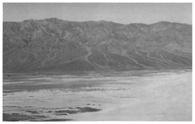
An alluvial fan is a sedimentary deposit located at a topographic break that is composed of fluvial and/or debris flow sediments and that has the shape of a fan either fully or partially extended, as illustrated by the Hanaupah Canyon alluvial fan in Death Valley, California. Courtesy of H. W. Hjalmarson.
The committee also notes that the potential for erosion and deposition, the related uncertainty in flow path behavior, and the imprudence of elevation on fill as a mitigation measure are joint and separate characteristics shared among many flood hazards on depositional environments other than alluvial fans, although not usually with the same intensity. It stands to reason that some of the same rules should apply to this more inclusive type of flood hazard, which the committee calls uncertain flow path flooding, as apply to alluvial fan flooding, which is, in fact, a type of uncertain flow path flooding.
In the simplest case, a fan is shaped like a simple cone emanating from a single, well-defined apex. In such a case, a stream follows more-or-less radial paths down the cone, and the contours on the map of such a fan are convex downslope. However, the fan-shape may not always be so apparent; for instance, it is obscured where the sedimentary accumulations from several source areas encroach on one another. At their downstream margins, fans merge with smoother depositional topography of the valley floor, river terraces, and lake and coastal deposits, and the channels may be small, shallow, and diffuse. Fans differ from pediments, some of which are cone-shaped, in that fans are formed by the accumulation of sediment, while pediments are erosional surfaces that are usually covered by a thin veneer of alluvium and colluvium.
Although alluvial fans are often thought to occur mainly in the western United States, they occur in a wide range of environments, including the Appalachian Mountains, western Canada, and various mountain, arid, and volcanic regions around the world. In North America, most fans that are subject to controversy are in the West because it is a rapidly urbanizing region and fans—with their relatively gentle terrain and views of the mountains—are appealing building sites.
Alluvial fans, and alluvial fan flooding, show great diversity because of variations in climate, fan history, rates and styles of tectonism, source area lithology, vegetation, and land use. For this reason, it is essential that any investigation of alluvial fan flooding include careful examination of the specific fan for which information is needed by specialists experienced in the study of alluvial fan processes and recognition of geomorphic indications of past and present flooding. The committee recognizes that the extent of site-specific examination may be constrained by factors such as the amount of time and money allocated to the project, the tools available to the investigator, and the investigator's experience. Nevertheless, it is essential to conduct at least one field inspection of every fan being delineated—to walk across its surfaces and along its channels.
The criteria used to assess whether an area is, or is not, subject to alluvial fan flooding must help the observer determine first, whether the area is a fan, and second, whether it is characterized by sedimentation and flow path uncertainty. Thus the process of determining whether or not an area is subject to alluvial fan flooding, and of defining the spatial extent of such flooding, can be divided into three stages:
-
Recognizing and characterizing alluvial fan landforms
-
Defining the nature of the alluvial fan environment and identifying active and inactive components of the fan; and
-
Defining and characterizing areas of the fan affected by the 100-year flood.
Progression through each of these stages results in a phased procedure that narrows the problem to smaller and smaller areas. In Stage 1, the landform on which flooding occurs must be characterized. If the location of interest is an alluvial fan, then the user progresses to Stage 2, in which those parts of the alluvial fan that still are active are identified. The term active means that flooding, deposition, and erosion have occurred on the fan and might continue to occur on that part of the fan. Those parts of the fan that have been active in recent time can be identified depending on data availability for the site and money allocated to the project. Each active part of the alluvial fan also is characterized based on the dominant types of processes that result in sedimentation. Finally, in Stage 3 the user determines whether or not flooding by the 100-year flood is still probable on those parts of the fan that still are active and estimates the extent of such flooding. Progression through these stages will require a variety of maps and photos, as well as a significant amount of fieldwork and analysis to fully understand the flood hazard.
The effects of erosion and deposition processes and flow path uncertainty on flood hazard severity are not limited to alluvial fans. Yet the term alluvial fan flooding suggests these processes are limited to alluvial fans and is therefore confusing. The Committee on Alluvial Fan Flooding recommends that the term alluvial fan flooding be applied only to flooding on alluvial fans. FEMA will need to develop a strategy to regulate other types of uncertain flow path flooding that do not occur on alluvial fans.
This report addresses a wide range of issued related to alluvial fan flooding. Chapter 1 presents an introduction to why identification of alluvial fan flooding hazards is controversial and the problems of definitions. Chapter 2 looks in more depth at fan types and flooding processes. Chapter 3 presents indicators developed to help delineate alluvial fans and alluvial fan flooding, based on the committee's definition and discusses methodologies to delineate flood hazards on alluvial fans. Chapter 4 contains seven examples analyzed by the committee in light of the definition and field criteria. The sites represent a range of flood processes, from unconfined water flooding and debris flows on untrenched active fans to confined water flooding in fully trenched inactive alluvial fans; the examples also show variable amounts of study—from intensive to casual. Chapter 5 presents a summary of the committee's conclusions and recommendations.
Key conclusions include the following:
-
Site investigation is essential to distinguish alluvial fans from other landforms and to identify which parts of an alluvial fan are subject to hazard.
-
Regulatory flexibility is necessary to realistically depict flood hazards given the variability in flood processes on alluvial fans.
-
The existing regulatory framework, which divides all flooding sources into either riverine or alluvial fan flooding, leads to inconsistency when imposed on specific sites.
-
Imposing the alluvial fan flooding paradigm instead of the riverine paradigm creates its own set of difficulties for sound regulation of the flood hazard.
-
The act of defining the type of flooding is independent from the act of deciding which methods are applicable for delineating the boundaries of the hazard.
-
The role of uncertainty in mapping flood hazards on alluvial fans is different from that for floodplain management and mitigation.
Key recommendations include the following:
-
The existing NFIP definition of alluvial fan flooding should be revised to reduce confusion and controversy. As noted earlier, this committee proposes a definition that limits the term to use only on alluvial fans and for FEMA purposes to the 100-year flood.
-
FEMA also can recognize that uncertain flow path flooding includes alluvial fan flooding as well as flooding on alluvial plains, deltas, and other landforms on which flow paths change.
-
During the delineation process, site-specific evaluation must be conducted because it is the key to determining which alluvial fans and parts of alluvial fans are subject to flood hazards.
-
When estimating flood hazards, FEMA should evaluate uncertainty directly instead of assuming it to be either nonexistent or random.
-
FEMA needs to expand the technical and regulatory input it receives in the delineation and regulation process, perhaps through the use of a technical advisory board composed of earth scientists, engineers, local regulating bodies, and those being regulated.
-
If FEMA elects to extend the current alluvial fan regulatory construct to any nonalluvial fan situation, it will need to change the term alluvial fan flooding to uncertain flow path flooding


