
1
Sacramento and the Struggle to Manage Flood Risk
Settling In The Floodplain
Sacramento, California, was settled literally on the banks of the Sacramento and American Rivers (see Figure 1.1) shortly after gold was discovered upstream at nearby Sutter's Mill in 1848. It has been plagued by frequent floods ever since. The problem of understanding and coping with flood risk was faced early (the first flood to inundate Sacramento occurred in January 1850) and often by the original settlers and continues today as a major scientifically underpinned public policy issue. It has subsequently been determined that the town of Sacramento was built in the middle of what was essentially an inland sea that local Native Americans warned appeared almost annually (Kelley, 1989). Presently, more than 400,000 people and $40 billion worth of property are vulnerable to flooding, including most of the city's downtown business and government areas, including the state capitol.
Risk Reduction Efforts
Since its founding, the city has struggled to protect itself from periodic floods by employing structural and land management measures. In a meeting of citizens it was decided to build Sacramento's first levee immediately following the January 1850 flood (Kelley, 1989). At present, much of the population lives behind levees along the two rivers (see Figure 1.2). Local and federal land use criteria govern the development that occurs in floodprone areas. In addition to Folsom Dam, completed in 1956, several small privately owned reservoirs upstream of the American River act to attenuate the flood runoff peaks issuing from headwaters.
A major flood in 1986 served as impetus for efforts by federal, state, and local entities to identify an acceptable and feasible set of measures to increase Sacramento's level of safety from American River floods. Numerous options were identified in 1991 by the U.S. Army Corps of Engineers (USACE) in a report known as the American River Watershed Investigation (USACE, 1991). Due to the controversial nature of many of the alternatives identified in that report, study participants were not able to reach consensus on any of the flood control options, including the construction of a dry dam (with no permanent storage of water) at Auburn, which was ultimately recommended by the USACE. In response, Congress directed the USACE to reevaluate available flood control options and, at the same time, asked the USACE to engage the National Research Council as an independent advisor on these difficult studies.
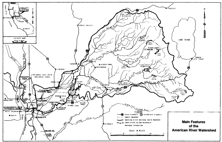
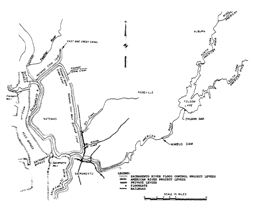
Figure 1.2
Existing flood control features of the American River watershed. SOURCE: Sacramento District, USACE, 1991.
Thus, for about 18 months in 1993-1995, a WSTB-formed committee was engaged in a study relevant to American River flooding and risk reduction. In 1995, the committee issued Flood Risk Management and the American River Basin: An Evaluation (NRC, 1995), a report that outlined an approach for improving the selection of a flood risk reduction strategy from the many available. The report contains a variety of recommendations covering improved operations of existing dams in the upstream basins, the integrity and hydraulic capacity of existing levees, statistical analysis of the historic flood record, better hydrologic monitoring in the basin, ecological analysis of alternatives, risk management analysis and water resources planning approaches, and research needs.
Current Planning Efforts And Controversies
In March 1996, the USACE and its non-federal affiliates completed the Congressionally directed reevaluations of flood control options and submitted recommendations to Congress. In response, Congress authorized a component of the recommended plan but not an adequate plan for the reduction of flood risk for the
Sacramento area. Evaluations of alternatives continue. At the time this report was being prepared, two major flood control approaches are under serious consideration. One option is for the construction of a $1 billion, 500-foot-high flood retention ("dry") dam upstream at Auburn. Funding for similar plans has been repeatedly rejected at the federal level for decades, largely due to high costs and environmental issues. Alternatively, a "stepped release" option seeks to raise and reinforce levees downstream from the Auburn site and to increase the outflow capacity of the existing Folsom Dam. To add considerable complication to the technically and politically difficult decision process, in January 1997 the American River experienced a major flood, nearly as large as and hydrologically similar to the "flood of record" that occurred just 11 years before in 1986.
Flood Flow Frequency Relationships
The occurrence of the 1997 flood suggested that it may be necessary to recompute flood flow frequency relationships for the American River at Sacramento. This second major flood in the past 11 years of 93 years of hydrologic history has significant implications for the flood risk management decision process. Simply put, climatic and hydrologic conditions may be changing so that larger, more damaging events would be expected to occur more frequently. If this is the case, residual flood risks—under present or future conditions—would likely be greater than previously thought.
Perhaps not surprisingly, recalculation of the flow frequency relationships has proven controversial. Occurrence of the 1997 flood has brought into question many issues of technical methodology (e.g., consideration of the paleoflood record, hydrometeorological non-stationarity, the validity of prescribed statistical approaches, and consideration of deterministic precipitation runoff modeling) that should be considered before further assessment of flood risk and consideration of alternatives for risk management can effectively proceed. Revised flood flow frequency relationships form the underpinnings of all future planning and must be realistic and professionally defensible in order to avoid controversy, to the maximum extent possible, and minimize uncertainties and errors in the decision process.
Hydrologic Risk and Uncertainty Analysis
The timing of the 1997 flood coincides with new thinking and methods in the field of hydrologic risk and uncertainty assessment. In 1994, the USACE adopted new risk and uncertainty analysis procedures for project evaluation that explicitly include uncertainties of hydrology, hydraulics, and economics of project planning. The primary advance in these new methods is that uncertainty is quantified and incorporated in project analysis (NRC, 1995). The U.S. Congress also recently commissioned a study of the USACE's risk-based analysis, which is just underway and is being carried out by a new committee organized by the WSTB. The WSTB 1995 American River study, the 1997 floods, and the concurrent WSTB study on risk-based analysis all suggest that a case study on updating flow frequency and other hydrologic/hydraulic parameters in the American River basin is particularly timely.
Technical Issues And Policy Implications
In February 1998, the USACE published a revised unregulated rain flood flow frequency analysis for the American River at Fair Oaks (USACE, 1998).1 This revision was the first since 1986, and was motivated by the occurrences in 1986 and 1997 of two major floods on the American River. As expected, the analysis produced a flood frequency curve that indicates that large floods are appreciably more likely than previously thought. Based on the newly estimated 100-year flood discharge, the levees protecting Sacramento would no longer provide protection against the 100-year flood according to criteria2 set by the Federal Emergency Management Agency—the effect of this essentially being "decertification" of the existing levees to provide 100-year protection and new requirements for the purchase of flood insurance. The revised flow frequency relationships also reduce the estimated level of protection of the flood control alternatives that are currently being considered for Sacramento.
USACE Approach
In calculating the revised flood frequency analysis, the USACE used daily flow data collected at the Fair Oaks gage (USGS #11446500) that were adjusted for the impact of upstream reservoirs.3 The adjustment consisted of adding the gaged mean daily flows to the daily change in storage at Folsom Lake and the lagged daily change in storage of the most significant reservoirs in the upper American River basin (the latter accounting for about 90% of all storage in the upper basin). The change in storage for the upstream reservoirs was lagged by one day to account for travel time. For each year of record, the maximum rain-event flows for 1-, 3-, 5-, 7-, 10-, 15-, and 30-day durations were extracted (USACE, 1998). Spring snowmelt events were excluded to avoid mixing populations.
Analyses
In conducting flood frequency analysis on each of the maximum flow series, the USACE was guided by Bulletin 17-B (IACWD, 1982). The mean, standard deviation, and coefficient of skewness of the logarithm of the flow series were computed from the flow series. (The 15-day and 30-day flows for 1977 were identified as outliers; but in order to avoid having the frequency curves cross, the flows were not censored.) For the 1-day, 3-day, and 5-day series, the skews used were weighted averages of the sample and regional skews; for the remaining durations, sample skews were used directly. The regional skews were based on the skew map given in Plate 1 of Bulletin 17-B, and weighting was based on the mean square errors
of the sample and regional skews, as suggested in Bulletin 17-B. No historical data were used in the analysis, reportedly because it did not appear that use of historical data would affect the results. Finally, the expected probability adjustment was applied to the estimated distributions. The three-day flow values computed by the USACE (1998) were 215,000 cubic feet per second (cfs) for the 100-year flood and 278,000 cfs for the 200-year flood at the Fair Oaks gage. For perspective, estimates of the three-day flow values for the 1986 and 1997 floods at Fair Oaks are 166,000 cfs and 164,250 cfs, respectively.
Reactions to USACE Analysis
The methods and results of the USACE flood frequency analysis have prompted several questions, comments, and criticisms from representatives of local, state, and federal government agencies, public interest groups, private citizens, as well as from the Corps itself These concerns were conveyed to the committee both orally and in writing over the course of this study. In addition, the committee identified other issues of concern. Below is a list of the issues that the committee recognized as potentially critical, and that are addressed in this report:
- accuracy of the adjusted daily flows used in the flood frequency analysis;
- failure of the USACE analysis to incorporate historical data or paleoflood information;
- consistency of the results with probable maximum flood estimates, envelope curves of maximum flood discharges, and rainfall runoff modeling results;
- use of the Bulletin 17-B map skew, given that the skew map is out of date and was developed for instantaneous flood discharges, not maximum daily flows;
- the use of the expected probability correction;
- adequacy of the log-Pearson type III distribution for modeling flood distributions over a wide range of exceedance probabilities;
- adequacy of the Bulletin 17-B procedure for accounting for historical data;
- the potential advantages of censoring the lower part of the distribution so that the estimation depends only on the largest floods;
- the fact that the record from 1950 to the present has many more large floods than the 1905-1950 record; and
- potential changes in flood probability due to global climate or regional change.
The first two issues concern data used (or not used) in the USACE analysis, and are discussed in Chapter 2. The next six issues concern methods of flood frequency analysis, and are discussed in Chapter 3. The last two issues concern climate and its bearing on the standard assumption that flood discharges are independent and identically distributed in time; this is the focus of Chapter 4.
In evaluating the issues of data, analysis methods, and climate, the committee strictly adhered to scientific standards. Hence, each technical recommendation, presented in Chapter 5, is based on best judgment of what is consistent with the scientific literature. It is important, however, to recognize the following:
- Estimations of flood quantiles and probabilities are based on a number of
- underlying assumptions, the validity of which cannot be absolutely established (e.g., the assumption that flood discharges are independent and identically distributed in time).
- Even if the underlying assumptions are reasonably correct, there are large standard errors in flood frequency analysis; even flood records 100 years in length have insufficient information to allow accurate estimates of quantiles such as the flood flow exceeded with a probability of 1% in any year (100-year flood discharge).
- The differences between our best estimate of flood quantiles (such as the 100-year flood discharge) and those of the USACE are small compared to the likely uncertainties in the estimates.
- Critical policy decisions in the American River basin, such as certification of the levees, Sacramento's floodplain status, and the adoption of flood mitigation strategies, are extremely sensitive to the official estimates of flood probabilities and quantiles. Hence, even though our best estimates are not significantly different from those of the USACE in a statistical sense, the differences may have significant policy implications.
The last issue is particularly important, and is discussed in Chapter 5.


