


Below is the uncorrected machine-read text of this chapter, intended to provide our own search engines and external engines with highly rich, chapter-representative searchable text of each book. Because it is UNCORRECTED material, please consider the following text as a useful but insufficient proxy for the authoritative book pages.
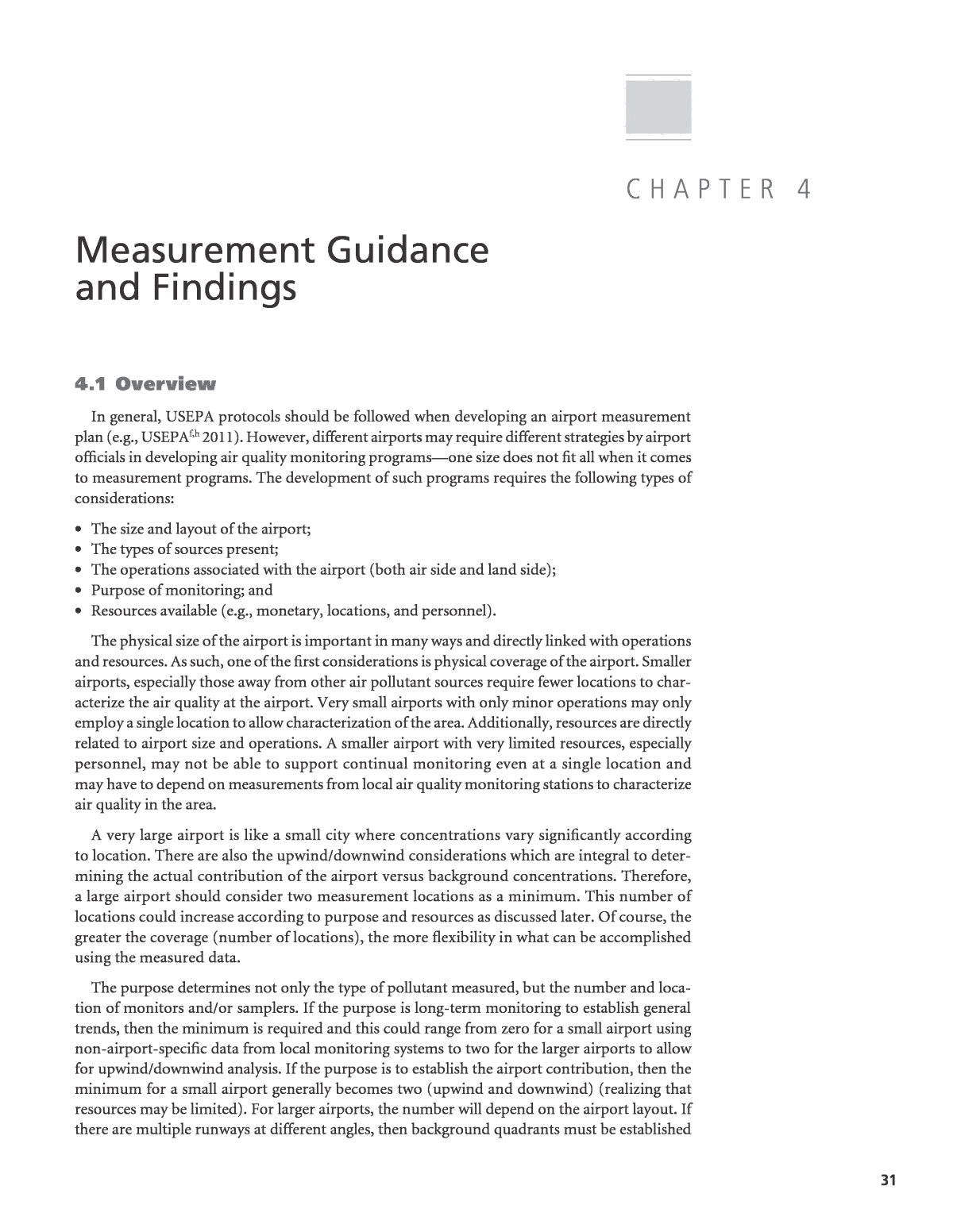
31 Measurement Guidance and Findings 4.1 Overview In general, USEPA protocols should be followed when developing an airport measurement plan (e.g., USEPAf,h 2011). However, different airports may require different strategies by airport officials in developing air quality monitoring programsâone size does not fit all when it comes to measurement programs. The development of such programs requires the following types of considerations: ⢠The size and layout of the airport; ⢠The types of sources present; ⢠The operations associated with the airport (both air side and land side); ⢠Purpose of monitoring; and ⢠Resources available (e.g., monetary, locations, and personnel). The physical size of the airport is important in many ways and directly linked with operations and resources. As such, one of the first considerations is physical coverage of the airport. Smaller airports, especially those away from other air pollutant sources require fewer locations to char- acterize the air quality at the airport. Very small airports with only minor operations may only employ a single location to allow characterization of the area. Additionally, resources are directly related to airport size and operations. A smaller airport with very limited resources, especially personnel, may not be able to support continual monitoring even at a single location and may have to depend on measurements from local air quality monitoring stations to characterize air quality in the area. A very large airport is like a small city where concentrations vary significantly according to location. There are also the upwind/downwind considerations which are integral to deter- mining the actual contribution of the airport versus background concentrations. Therefore, a large airport should consider two measurement locations as a minimum. This number of locations could increase according to purpose and resources as discussed later. Of course, the greater the coverage (number of locations), the more flexibility in what can be accomplished using the measured data. The purpose determines not only the type of pollutant measured, but the number and loca- tion of monitors and/or samplers. If the purpose is long-term monitoring to establish general trends, then the minimum is required and this could range from zero for a small airport using non-airport-specific data from local monitoring systems to two for the larger airports to allow for upwind/downwind analysis. If the purpose is to establish the airport contribution, then the minimum for a small airport generally becomes two (upwind and downwind) (realizing that resources may be limited). For larger airports, the number will depend on the airport layout. If there are multiple runways at different angles, then background quadrants must be established C h a p t e r 4
32 Guidance for Quantifying the Contribution of airport emissions to Local air Quality to allow the upwind concentration to be determined regardless of wind direction. This most likely results in a minimum of four locations and, if resources are available, even more measure- ment locations may be needed to further define the airport contribution. Two common purposes of monitoring that occur at airports are the regulatory requirements of NEPA and Conformity. Regarding NEPA, monitoring can play an important role in the fol- lowing three things: establishing the background concentration, establishing if the NAAQS are approached or exceeded, and trend analysis. When monitoring is used to evaluate against the NAAQS or in the cases where it is needed for conformity analysis, then the number of locations is determined by the âhot spotsâ on the airport, where a hot spot is a location where elevated concentrations occur. Hot spots often occur on the land side, primarily from motor vehicle activity. To determine the number of monitors on the land side, the analyst should evaluate intersections, the terminal area, parking areas, and maintenance/storage facilities using the EPA protocol for determining the top locations. This could result in multiple monitoring locations. On the air side, possible monitoring areas include heavily used gate areas and, to a lesser degree, locations where aircraft queues occur. Again, multiple monitoring locations could be needed. Figure 4-1 summarizes the number of monitoring locations needed. 4.2 Pollutants Measured Two basic categories of pollutants to measure can be defined: criteria pollutants and non- criteria pollutants. Criteria pollutants (i.e., those pollutants with defined ambient standards as determined and implemented by the NAAQS) include carbon monoxide (CO), oxides of nitrogen (NOx), sulfur oxides (SOx), ozone (O3), particulate matter (PM2.5 and PM10), and lead (Pb). Non-criteria pollutants include greenhouse gases (GHG), hazardous air pollutants (HAPs), and pollutants of specific concern (e.g., ultrafine PM). The primary GHG to consider is carbon dioxide (CO2). Each of these pollutants is discussed in the following paragraphs and summarized in Table 4-1. Figure 4-1. Number of monitoring locations.
Measurement Guidance and Findings 33 On the air side, the measurement data has shown that CO is not significantly increased along the taxiways and runways and measurements provide little benefits. This is also shown by other studies (e.g., Wayson 2003). As such, the only place to consider is the gate area. But even here the public is not significantly exposed (i.e., the public is exposed for very short durations) so mea- surements would mainly be conducted for worker considerations and not necessarily NEPA. On the land side, areas that could require CO measurements are enclosed areas where motor vehicle activity occurs such as in parking garages or the terminal drop-off area if covered. As such, CO measurements are recommended only in certain defined areas and not on the airfield except to develop background concentrations. NOx is an important consideration at airports. Aircraft have become more efficient in fuel burn, thereby reducing pollutants such as CO and hydrocarbons, but NOx continues to be important. Motor vehicles and ground support equipment, especially diesel vehicles, also emit significant amounts of NOx. As such, NOx measurements are recommended on both the air side and land side. An important point to measuring near aircraft movements is to do so where high power modes, such as takeoff, occur. SOx is a function of the sulfur in the fuel, which is still significant in Jet A, but future legis- lation could reduce fuel sulfur content. As sulfur levels change, so does the SOx impact. SOx emissions are interdependent with PM emissions. For these reasons, SOx measurements on the air side could still be important for specific needs, but are not recommended as highly as NOx. Of note is that PM measurements may often supply surrogate information on SOx. On the land side, the need for monitoring is even less since low-sulfur fuels have been mandated for motor vehicles. O3 is a secondary pollutant, formed primarily from the precursors of NOx and hydrocarbons, and elevated concentrations occur hours downwind of the source. Near airports, O3 depression (reduced concentrations) actually occurs as it reacts with the NOx emissions. As such, ozone is not recommended for measurements at airportsâinstead the precursors are more important and provide more meaningful results. PM is an important pollutant at airports. This is because the PM emitted from aircraft is predominantly below 2.5 micrometers in aerodynamic diameter (PM2.5) and emitted in suf- ficient quantities to be significant. Indeed, most PM emissions from aircraft tend to be in the ultrafine category (<0.1 µm) which can cause serious human respiratory damage. PM concen- trations can be significant on both the land side and air side, and as such, it is recommended Pollutant Typical Sources When Measurements Recommended CO Aircraft, motor vehicles, support equipment, combustion sources, construction equipment Only for special use NOx Aircraft, motor vehicles, support equipment, combustion sources, construction equipment General trends, NEPA/conformity analysis, special use esu laiceps ,sdnert lareneG tfarcriA xOS O3 Secondary pollutant, not generated by sources directly; primary precursors are NOx and hydrocarbons Not recommended PM Aircraft, motor vehicles, support equipment, combustion sources, construction equipment, brake/tire wear, stationary sources depending on fuel use, ambient entrainment General trends, NEPA/conformity analysis, special use Pb Piston aircraft and leaded fuel operations Only for airports with substantial piston aircraft operations CO2 Aircraft, motor vehicles, support equipment, combustion sources, construction equipment For special studies and combustion source tracing HAP Aircraft, motor vehicles, support equipment, combustion sources, construction equipment For special studies Table 4-1. Measurement recommendations for pollutants of concern at airports.
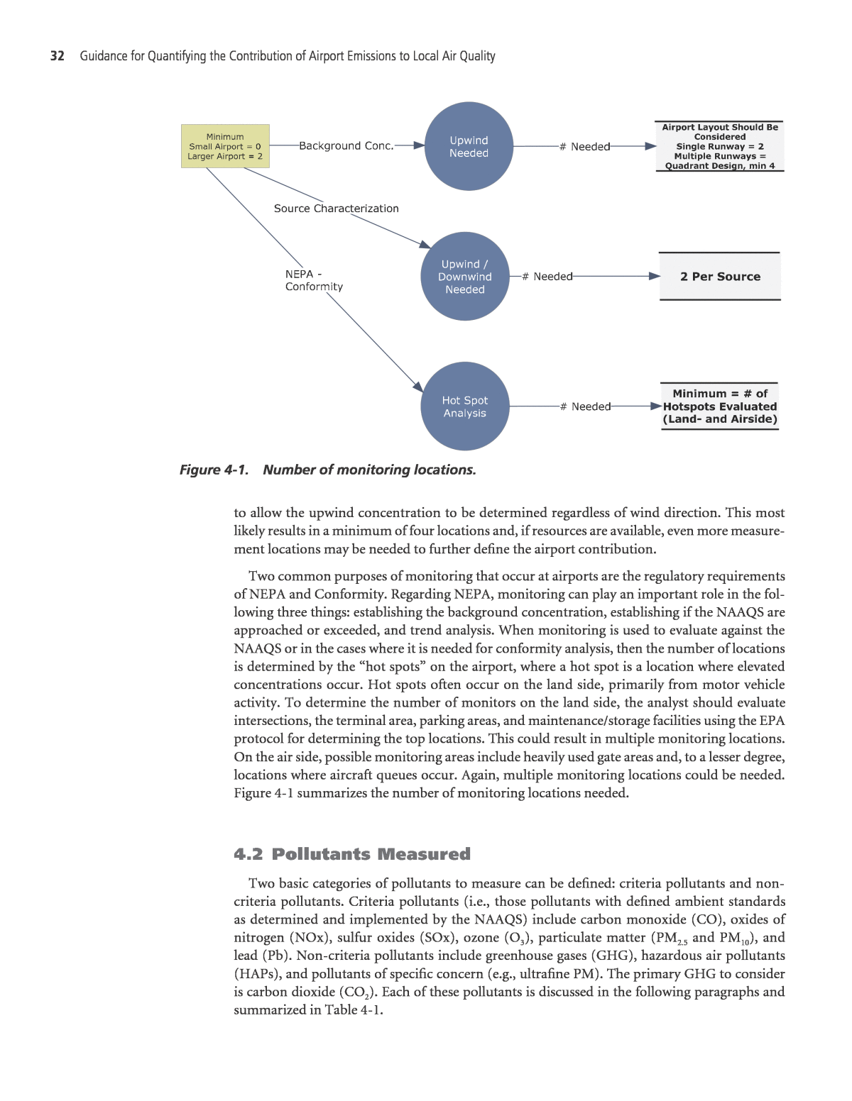
34 Guidance for Quantifying the Contribution of airport emissions to Local air Quality that measurements be taken separately to account for motor vehicle activity and airfield activ- ity. Additionally, point sources such as heating plants could also be significant contributors, depending on the fuel used and source controls in place. Pb becomes a concern if operation of piston-powered aircraft is substantial. Pb is used in aviation fuel (Avgas) and is known to have neurological impacts on humans. As such, Pb is a listed HAP. Pb is not a concern from most other sources at an airport, and measurements are only recommended for airports with substantial piston aircraft operations with the runway ends being the most significant location according to recent EPA documents. However, fueling opera- tions for the piston aircraft could also be a significant source. Ambient hydrocarbon and HAP species are not currently regulated, with the exception of Pb, but remain a concern to the public and generated by multiple airport sources. Measurements of HAPs is only recommended for special uses (e.g., health risk assessments) and then only a subset of the total. For example, measurement of formaldehyde has been shown to be proportionally related to other HAPs (USEPAb 2009). It should also be stated that mass-wise, carbonyls such as formaldehyde comprise the majority of HAP emissions (Wood 2008). Therefore, using simple measurement techniques for formaldehyde could be used as a surrogate for other HAPs occur- ring at airports. The USEPA has established an extensive list of HAPs, but the following appear to be detectable in aircraft engine exhausts (USEPAc 2009): ⢠1,3-Butadiene; ⢠Acetaldehyde; ⢠Acrolein; ⢠Benzene; ⢠Ethylbenzene; ⢠Formaldehyde; ⢠Isopropylbenzene; ⢠Methanol; ⢠N-xylene and P-xylene; ⢠Naphthalene; ⢠O-xylene; ⢠Phenol; ⢠Proprionaldehyde; ⢠Styrene; and ⢠Toluene. 4.3 Upwind and Downwind Concentration Assessments An upwind/downwind analysis is needed to compare results from EDMS/AERMOD to mea- sured results without assuming a background concentration. The basic assumption is that pol- lutants migrate to the airport from other area sources and contribute to the overall measured concentration. It follows that measurement locations upwind of airport sources would only include those from background sources. Subtracting these concentrations from the measure- ment locations downwind of airport sources should lead to concentration values only due to airport sources. Figure 4-2 demonstrates this idea for one position, Position B, using the mea- surement campaign at IAD as an example. Of course, the analysis method repeats for other positions but with different results. In Figure 4-2, the IAD area has been divided into four defined angle quadrants based on the runway orientation which is usually based on the predominant wind directions. Each quadrant, named for the wind angles it includes, represents a grouping of wind angles that would cause the
Measurement Guidance and Findings 35 local concentrations at different positions to be influenced by various runway activities. Other airports would require specialized assessment based on the characteristic wind angles. Multiple scenarios were investigated to derive the background levels from the measurement data by combining the consideration of wind flow and runway operations during collection times. For each quadrant, background measurement positions were identified to allow the eval- uation of the concentrations due to aircraft activity as indicated below: C C K C Eq. 4-1A dnwind upwind= â( ) where CA = Concentration due to airport activity Cdnwind = Downwind concentration Cupwind = Upwind concentration (assumed background) K = Conservatism factor Of note is the conservatism factor K. This has been included for two reasons: (1) to provide a measure of conservatism and (2) the realization that some airport sources may still have an effect on the concentrations in low wind conditions or from other mobile sources such as motor vehicles or construction equipment in the area. Because the K value is intended to help account for some of the uncertainties surrounding the derivation of the airportâs air quality contribu- tions, the value may be estimated using measured data (either a current dataset or historical data). The differences in the measured concentrations from receptors that are relatively close would provide an indication of the K value. This value would provide some conservatism to account for the transient influences of distance (e.g., location of receptors), weather (e.g., wind direction) and sources that are either near or cross the upwind/downwind boundaries. Concen- trations based on shorter averaging periods may experience greater variations than those based Figure 4-2. Wind analysis for Position B.
36 Guidance for Quantifying the Contribution of airport emissions to Local air Quality on longer averaging periods. A nominal K value of 0.9 may be reasonable for most cases, indicat- ing about 10% conservatism. However, based on the strength of the transient influences, other more conservative values, such as 0.8 (20% conservative), may be justified. Again considering Figure 4-2, if the wind is flowing from Quadrant 301-011, and there is no activity on Runway 01L/19R, then Position B is upwind of all (or most) airport sources. Although some contribution from airport activity other than aircraft may occur, the location still represents a good estimate of background concentration for the airport. This is thought to be much better than trying to estimate the background concentration from permanent monitor- ing stations many miles away influenced by completely different sources. Using the measured concentrations at Position B as background and subtracting from the measured concentrations at other positions then results in a concentration that represents the increase due to airport activity (see Equation 4-1). This allows a direct comparison to the results predicted by EDMS/AERMOD that only includes the airport sources. Additionally, depending on wind direction and runway activity, Position B could be a downwind position and the analy- sis would be completed using another position as background. Using this approach, the wind conditions have been reviewed and all positions designated as upwind or downwind positions for the various runway activity. The background receptor locations are ⢠Quadrant 011â121: Location M ⢠Quadrant 301â011: Locations C and X (X only measured PM) ⢠Quadrant 191â301: Location K ⢠Quadrant 121â191: Location M Operations have been reviewed to closely determine the important source locations for each analysis hour. Background concentrations have been determined and the simple method as shown in Equation 4-1 has allowed the contribution from the airport activity to be determined. For simplicity, it would be desirable to have a single value for a background level. Of course, the weather is unpredictable and nearby sources are not often constant emitters. There is considerable variance day to day and hour to hour. Additionally, it is not possible to separate longer term aggregate measurements (1-hour, 3-hour, 24-hour) into shorter time periods with certainty. This is particularly true of the 24-hour particulate matter sampling. This causes the analysis complexity to increase. In these cases, a statistical averaging approach is needed to determine the background and concentration contribution due to airport activity. Vari- ous methods are being used to analyze the data in these conditions. All follow the same basic format of C C KC f time f operations EA dnwind upwind= â ( )â ( )( ) q. 4-2 where f(time) = a statistical function of the upwind/downwind time at a position f(operations) = a function of operations during the upwind and downwind times Methods vary with both uncertainty and resource commitment. The research team reviewed different methods and the relative merits of each. It was decided that the best time function, f(time), in Equation 4-2 (based on airport resources) was to use a weighted average of the upwind locations based on the time fraction of wind direction. Stability was not included because it was thought that this was already a function of the measured concentration. As such, the f(time) is equivalent to the time each upwind site exists. Or
Measurement Guidance and Findings 37 C C K t C t C f operaA dnwind 1 1upwind 2upwind= â â â â( )2 tions Eq. 4-3( )( ) where C1upwind, C2upwind = concentration for two primary upwind locations due to wind direction t1, t2 = fraction of time during defined time period where each location is upwind Additionally, the operations function, f(operations), was determined to not be a consideration for IAD. If measurement locations for other airports were located such that no location was truly upwind of all major sources, this could be implemented and could be as simple as considering the times when aircraft are present during different wind flows. This resulted in the following equation to determine CA and allow a direct comparison to EDMS results: C C K t C t C Eq. 4-A dnwind 1 1upwind 2upwind= â â â â( )2 4 4.4 Measurement Locations Each airport is unique. As such, measurement locations will vary by airport. Some general guidance is provided, but the final locations should be determined after a careful review of airport sources, local sources, and resources available. The determining factor in monitor placement is the purpose of the measurement(s) which determines final use of the data. The previous section presented a methodology that greatly increases the use of background information and helps to improve modeling results. If data are to be used for background, then locations should be situ- ated so as to define the upwind component for the wind flow as related to sources. Related to this is the ability to determine the airport contribution by use of downwind locations. This requires consideration of the runway, terminal, and other facility layout details as indicated in Figure 4-3. On the left is a simple single runway where aircraft are taking off into the wind and a mini- mum of two measurement locations are needed. On the right, for a more complex airport, the quadrant approach applies because of changes in runway usage for operations and wind. (This methodology is described more in Appendix B.) Additionally, local sources may also cause Figure 4-3. Examples of areas for monitor placement for background and airport contribution considerations.
38 Guidance for Quantifying the Contribution of airport emissions to Local air Quality changes in locating monitors. For example, a large freeway or a manufacturing source near the airport should be considered because background from this facility could be substantial. Other guidelines for placement include the following: ⢠Locate away from major sources unless characterization of that source is a reason for placement. ⢠When locating on the airfield, locate as close to the apron, taxiway, and/or runway as safely possible (and permitted) to determine the impact of the aircraft. With distance the concentrations decrease and, for aircraft, individual movements are difficult to record. In addition, consideration should be given to measurements at multiple heights given that the initial release is somewhat elevated and plume rise may also cause the plume to be elevated. ⢠Locate away from structures and buildings to the degree possible to avoid wake influence (see EPA guidance). ⢠In the case of long-term measurements and/or real-time instrumentation, both shelter and line power will be required. ⢠Evaluate whether the location will meet the data need. ⢠Safety is always a consideration. ⢠Security is always a consideration. 4.5 Equipment Equipment used for air pollutant measurements and meteorology are primarily established by data needs, the intended measurement period(s) (e.g., 1 month, 1 year, continual), power availability, enclosure availability, safety, and security. The USEPA has defined equipment that is acceptable for use in state or local air quality surveillance systems in accordance with Title 40 CFR Part 53 (CFR 2006) which is referred to as reference or equivalent methods and listed by the USEPA (USEPAf,i 2011). This equipment requires a shelter for climate control and line power and, if applied properly, should follow all Ambient Air Monitoring Regulations (CFR 2006). For the gaseous compo- nents, this equipment is often referred to as real-time analyzers because a continuous sampling process occurs. For PM, filters have been used, and, as such, a 24-hour period occurs for each sample. The research team has found that short-term PM measurements may not supply suf- ficient filter loading to allow a quality sample. If an airport is considering very high fidelity sampling or sampling on a continuous basis, other equipment types, such as BAM equipment which has been approved as an FEM for PM2.5, should be used. Measurements at airports often require monitoring at locations away from available power. In these situations, equipment that requires no line power (e.g., uses battery power), is weather resistant, and easy to handle must be used. Some gases and PM can be monitored through sam- pling (i.e., rather than through continuous monitoring). Although such sampling often results in less fidelity, it is still an important option to collect necessary data and needs to be balanced with the resources available. Table 4-2 provides suggestions on monitoring methods for the important airport pollutants. 4.6 Measurement Schedule Measurement schedules, including total duration, will be based on a balance of the purpose of the measurements and resources available. With a lack of airport-specific information on this subject, applicable USEPA guidance should be followed (USEPAf,h 2011).
Measurement Guidance and Findings 39 The overall schedule for a monitoring campaign can range from just a few days for a spe- cific need to years for continuous measurements if used in trend analyses. Considerations for short-term sampling for specific needs include seasonal variations, unusual weather conditions, atypical operations, and precipitation events. There is no strict guidance on the length needed for short-term sampling, but the analyst should review the USEPA guidelines and the necessary data to ensure the data will be sufficient. In long-term or continuous sampling, it is important to represent all seasons over multiple years for a high confidence level. Therefore, reviews of climate data for the area of interest are necessary to obtain a good understanding of how the measurement schedule should be developed. 4.7 Planning Although the previously discussed issues and items (e.g., measurement locations and equip- ment) can be considered separately to a certain extent, eventually they need to be pulled together into a cohesive monitoring plan. Careful planning is crucial to the success of any monitoring campaign. Resources such as those offered by USEPA should be reviewed to increase the likelihood of success (USEPAf 2011). At a minimum, an airport measurement plan should include the following elements: ⢠Determination of the final use of data, ⢠Selection of locations, tnempiuqE noitpircseD gnilpmaS tnatulloP CO continuous sampling compliance with CFR Part53 desired reference or equivalent method (i.e., non-dispersive infrared) CO short-term or hot spot sampling battery powered bag sample units with the reference or equivalent method used to test captured air NOx continuous sampling compliance with CFR Part53 desired reference or equivalent method (i.e., chemiluminescence) NOx short-term or hot spot sampling battery powered bag sample units with the reference or equivalent method used to test captured air (note: reactivity of gases must be considered) SOx continuous sampling compliance with CFR Part53 desired reference or equivalent method (i.e., spectrophotochemical)(note: not generally recommended at airports) PM continuous sampling compliance with CFR Part53 desired reference or equivalent method (i.e., filter with impaction specific for PM10 and/or PM2.5) PM short-term or hot spot sampling battery powered filter unit specific for PM10 and/or PM2.5 Pb continuous sampling compliance with CFR Part53 desired reference or equivalent method (i.e., filter in hi- volume sampler) Pb short-term or hot spot sampling battery powered filter unit CO2 continuous sampling non-dispersive infrared CO2 short-term or hot spot sampling battery powered bag sample units with the reference or equivalent method used to test captured air HAP continuous sampling flame ionization detector (note: not generally recommended) HAP short-term or hot spot sampling evacuated canisters or sample cartridges. formaldehyde may be used with proportionality factors to determine other HAP concentrations Meteorological continuous sampling at two heights with appropriate data logger system. Relative humidity and barometric pressure area also possibilities but not as important Meteorological short-term or hot spot sampling Battery operated u,v,w sonic anemometers with appropriate data logger u,v,w sonic anemometers and aspirated thermometers Table 4-2. Suggested air pollutant monitors for use at airports.
40 Guidance for Quantifying the Contribution of airport emissions to Local air Quality ⢠Selection of equipment, ⢠Determination of time required to meet final data needs, ⢠Equipment calibration protocols, ⢠Analysis methods to be employed, ⢠Quality assurance during collection and data analysis, and ⢠Consideration of safety and security. The final use of the data is the key consideration. The first part of the plan should include the key goals followed by a critique of how the data will be used. This includes consideration of regulatory requirements (e.g., are the data to determine compliance with a NAAQS), which pol- lutants are of concern, previous or ongoing measurements in the area, total duration of sampling needed to meet goals, and level of variability acceptable to meet goals. Once the needs of the data and the goals of the monitoring plan have been established, the pol- lutants to be monitored will have been determined. This then allows the sample locations to be determined. If enclosures and/or line power are required, the first consideration is where these would be available (or set up). The first step in this process should involve the use of a good map of the area. Contour maps are also very helpful in identifying possible disturbances to local air move- ments. Initial locations can then be selected, followed by field reconnaissance (which is always needed for reasons including the ability to take into account recent changes to the area, security fences/walls that do not appear on a map, and drainage conditions). The previous discussions on site locations should be considered to evaluate and determine the best locations to monitor. The last step should involve consultation with field operations and safety officers to confirm that these locations are valid, in no way hinder the field operations, and meet all requirements set for safety, especially if some of the monitoring work is to be conducted on airport property. Appropriate measurement equipment will need to be selected and the previous discussions should be consideredâdecisions regarding the use of real-time samplers or remote samplers (e.g., battery powered) will need to be made. If real-time sampling is used, not only must the specific equipment type be decided, but considerations for the enclosure and line power must be made as well. This will also require a sample manifold system. Best systems use a non-reacting manifold with a downstream pump. Calibration gases and procedures must also be considered. Meteorological data are usually available near most airports from existing weather stations, but may not be very âcloseâ to the measurement locations. Therefore, if resources allow, additional meteorological data (more representative data) should be obtained using meteorological equip- ment. Multiple locations are desirable, especially if topography is a concern, but resources or avail- able locations away from obstacles may not always be available. For hot spot analysis or at smaller airports, one location may be sufficient. However, for more in-depth projects, a minimum of one location at two heights (e.g., temperature, wind speed, and wind direction at two heights) is advised to help better characterize local temperature and wind vertical profiles. As previously indicated, the sampling schedule needs to be balanced with available resources. However, even in planned short-term measurements, additional time should be included to account for set up, shut-down, and days with precipitation. Erroneous data may occur on days with precipitation. Time for calibration of data must also be scheduled. One common error for remote sampling is not allowing sufficient time to collect samples to bring back to be analyzed. Navigating in and around a large airport can easily take hours. Where sufficient resources exist, allowing more time to collect more data (more than the minimum) is advised. For NAAQS or conformity determination, the aforementioned USEPA requirements should be followed closely. Data are without merit if proper calibrations do not occur. This may be as simple as having a calibration curve developed for a sample pump used for cartridge sampling or as complex as using multiple gas mixtures to determine dilution times and flame ionization detector response
Measurement Guidance and Findings 41 when using a gas chromatograph. Regardless, a rigorous calibration routine must be included in any complete sample plan. Analysis methods are also important considerations. This is not only related to how col- lected samples will be measured but also how the data will be analyzed. In the case of real-time analyzers, there is no additional analysis to determine the concentration of the sample. In the case of impaction on filters or absorption on media, it is best to send to a standard laboratory for analysis. This will not only greatly reduce the cost for the airport but provide a measure of traceability that might not occur with establishment of a field lab. For capture of gases using bag samples, analysis should occur at the airport using the reference or equivalent method real-time analyzer. As always, analyzers should be calibrated using National Bureau of Standards (NBS) traceable calibration gases. In addition to calibration, an overall quality assurance plan is needed. As previously cited, the USEPA has established guidelines which are included in a large 5-volume compendium of topics related to ambient air measurements. These topics include, but not restricted to, test methods, sampling, analysis, and QA (USEPAh 2011). Safety and security must be considered as well. All rules at an airport (especially those involv- ing the air side) should be carefully followed to prevent injuries and violations of any airport rules. The airport should be well-apprised of all measurement activities and schedules. Sampling outside of the airport in areas with public access may require additional considerations (e.g., enclosures) to ensure the equipment and samples are uncontaminated. Whenever possible, it is advisable to have more than one person check equipment and/or gather samples because this usually increases the likelihood of following safety precautions. In terms of expectations, it should be recognized that an optimal sampling plan is difficult to developâthere are always items that will be difficult to foresee. Even when the same set of mea- surements are planned to be conducted by the same individuals at the same airport, a measure- ment plan will never be truly perfect. The hope is that the individuals developing the plan will be able to account for most potential issues that could arise and have appropriate contingencies set up. Many past monitoring efforts have not been completely successful because the plans were too ambitious with given resources, including time, personnel, and budgets.
