


Below is the uncorrected machine-read text of this chapter, intended to provide our own search engines and external engines with highly rich, chapter-representative searchable text of each book. Because it is UNCORRECTED material, please consider the following text as a useful but insufficient proxy for the authoritative book pages.
H-1 APPENDIX H: DETAILED CASE STUDIES As indicated previously, the following sites were selected: ⢠Suburban Mobility Authority for Regional Transportation (Detroit, Michigan) ⢠Metropolitan Council and Minnesota Valley (Minneapolis / St. Paul, Minnesota) ⢠Tri-Met (Portland, Oregon) ⢠South Metro Area Rapid Transit (Wilsonville, Oregon) ⢠King County Metro (Seattle, Washington) ⢠Capital District Transportation Authority (Albany, New York) ⢠Broward County Transit (Broward County, Florida) ⢠Regional Transit District (Denver, Colorado)
H-2 1. DETROIT, MICHIGAN Suburban Mobility Authority for Regional Transportation SMART operates in three counties in the greater Detroit area â Wayne, Oakland and Macomb Counties â and is notable among major metropolitan transit agencies in that its service area does not include the central city. The service area includes all or portions of 86 communities with a total population of approximately 3.3 million. SMART operates 62 fixed routes with peak vehicle requirements of 230 buses, serving suburb-to-suburb trips and trips between suburbs and Detroit. Total ridership on the fixed routes is 8.4 million annual unlinked trips. In response to the suburban nature of its service area, the agency has also introduced several types of demand-responsive services, including advance reservation, flex route, ADA paratransit, and Job Express, a connector service that accommodates same-day requests for pick- ups and drop-offs between a fixed-route bus stop and employment locations in specified zones. SMART also indirectly provides service in 55 communities through a Community Partnership Program, which is a vehicle procurement program designed to help local communities acquire vehicles using federal funds and local property tax revenues. Local communities provide advance reservation services using 136 vehicles purchased through this program. Total ridership on demand-response services is more than 1 million rides per year, with approximately 60 percent on services operated by community partners. SMART relies on a property tax for much of its public funding. A dedicated transit millage was passed by communities in the three counties in 1995 and is reauthorized by referenda every four years. This need for periodic voter approval has encouraged SMART to become very responsive to community mobility needs. The Community Partnership Program is one element of this community orientation. SMART sets aside a portion of each communityâs property tax contribution to fund local services. While some communities use their discretionary funds to enhance local services operated by SMART, many have found it more cost-effective to procure vehicles and operate their own services. The agencyâs seven-member board includes two representatives from each of the three counties it serves and one representative from adjacent Monroe County. The system operates out of three main garages, one in each county. The Board has given management significant latitude to experiment with new services. SMART identifies entry-level employees, especially those who live in Detroit and work in suburban employment centers, as one of its key markets. The agency has implemented a marketing program with the tagline âGet a Job, Get a Rideâ aimed at service industry workers whose job opportunities are increasingly located in suburban areas. The program provides a free bus pass to full-time employees during their first month of employment at participating employers. This case study focuses on a group of services in the Troy area of Oakland County that represent how suburban transit services can evolve over time. SMART has provided dial-a-ride service within the city limits of Troy since 1975. A major suburban employment corridor has also developed along Big Beaver Road in the southern part of Troy over the last few decades. To relieve the dial-a-ride service from repetitive daily travel patterns associated with major employers, the original dial-a-ride service has been supplemented by two demand-responsive services that focus on specific submarkets within the service area. The Big Beaver Job Express provides a connection between a transit center at one end of the Big Beaver corridor and major
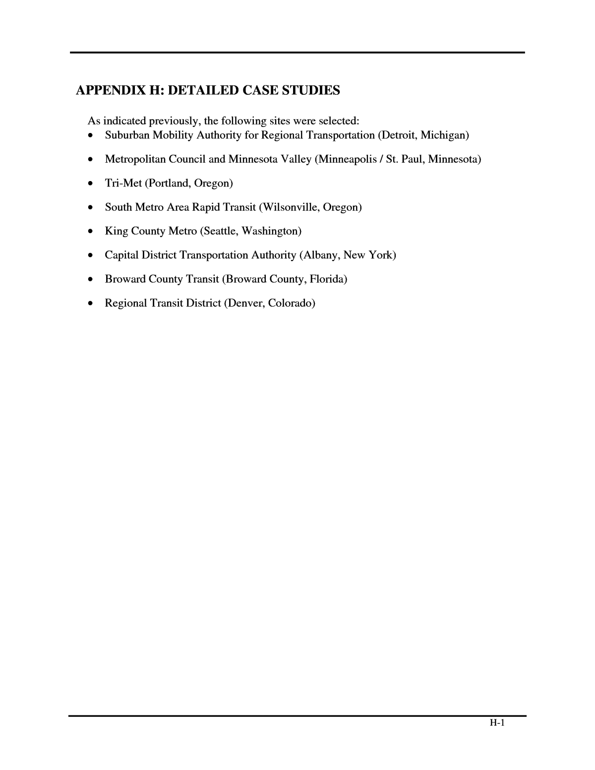
H-3 employers in the area. The Oakland Mall Job Shuttle provides a connection between another transit center and employers at the opposite end of the Big Beaver Road corridor. This case study also includes a second Job Express service in a much less densely developed area. The Lakeside Job Express operates as a connection between a transit center and entry level jobs at a cluster of big-box retailers in an automobile-dominated area where pedestrian access is very difficult. Two other demand-responsive services operated by SMART elsewhere in the Detroit metropolitan area are presented for comparison and contrast, but at a lower level of quantitative detail than the Troy area services and the Lakeside Job Express. These services include the Groesbeck flex route and a third Job Express service centered at Fairlane Town Center, a regional shopping center surrounded by major employers, including the Ford Motor Company headquarters. Regional Travel Patterns Figure H-1 shows the distribution of activity throughout the Detroit metropolitan area. Activity is measured by trip ends (origins or destinations) per square mile, as represented in the Southeast Michigan Council of Governments (SEMCOG) regional travel demand model. Blue areas have the least activity density, generally representing rural areas on the edge of the metropolitan area. Red areas represent areas with the highest density of activity. Compared to other metropolitan areas with stronger downtowns, Detroit has a much larger share of activity in moderately dense urban neighborhoods and suburban business districts, which are represented as green areas. The Troy area, which includes the Troy â Birmingham Dial-a-Ride, Big Beaver Job Express, and Oakland Mall Job Shuttle service areas, is characterized by a ridge of activity in its southern portion. The Groesbeck flex route operates along a local ridge of activity. The Fairlane and Lakeside Job Express services operate around local peaks of activity.
H-4 Figure H-1: Detroit Metropolitan Area Activity Surface Troy Downtown Detroit Source: Southeast Michigan Council of Governments regional travel demand model, 2005.
H-5 Troy Area Services The Troy area is served by an established general public demand-response service, the last survivor of a number of community dial-a-ride services introduced in the 1970s. The service provides connections between all points in the Troy city limits on request between 6:00 a.m. and 6:00 p.m. weekdays. Customers call a SMART toll-free hotline to request pick ups. SMART processes the requests in the order received, usually within one hour after the call is placed. Advanced reservations are also accepted. In late 2003, the Troy dial-a-ride was merged with a similar community transit service in nearby Birmingham and Beverly Hills to reduce operating costs. The combined service operates using five accessible 12-15 passenger cutaway vans, as shown in Figure H-2. SMART charges a base community transit fare of $2.00 for the service, plus $0.25 for a transfer to fixed-route service. Discounts are available for seniors, people with disabilities, Medicare patients, and children under 6 years of age. Figure H-2: SMART Community Transit Vehicle
H-6 SMART introduced a Job Express, an employment-oriented âlast mileâ service, in each of its three counties in 1995 following the initial property tax referendum. Each of the Job Express services operates as a point deviation service from a single hub where connections to fixed routes are available. Service areas were limited to approximately 2 square miles to keep round trips from the hub to approximately 10 minutes. Because of the short trips, services generally operate without schedules â they just return to the hub as frequently as possible. Timed transfers with fixed-route services are not an explicit objective, but the service frequency is intended to keep wait times as short as possible. Drivers are typically drawn from the agencyâs paratransit roster. The Big Beaver Job Express serves one of the five largest employment centers in the region, an area that rivals downtown Detroit in employment concentration. The Big Beaver Job Express was implemented as an overlay service in the Troy dial-a-ride area, where it relieved the city-wide service of a number of peak-period commuter trips concentrated along Big Beaver Road. The service operates using one van from 6:00 a.m. to 10:00 a.m. and from 2:30 p.m. to 6:00 p.m. on weekdays. All trips begin and end at the Somerset Collection, an upscale regional shopping center where management has welcomed the access provided by the convergence of six fixed routes, especially for mall workers. Trip itineraries are designed by the driver on the fly based on drop off requests made by passengers on boarding, telephone trip requests relayed by the dispatcher, and return trip requests made by passengers earlier in the day. Base fares for all Job Express services are $0.25 each way, which is equivalent to the cost of a fixed-route transfer. The Oakland Mall Job Shuttle is similar to the Big Beaver Job Express in its peak-period employment orientation, but it operates as a point deviation route between two timepoints â the Oakland Mall transit center on the south and the Meadowbrook Plaza shopping center on the north. The route taken between the two points varies based on pick up and drop off requests. Four 4H-minute round trips each weekday morning and three trips each weekday afternoon are scheduled. The service operates using one van. As with the other services, pick up requests can be arranged with the driver or made by telephone to SMARTâs toll-free number. The agency charges a two-level fare depending on boarding location. Passengers boarding at either timepoint pay the $1.50 line-haul fare. Passengers boarding anywhere else pay the $2.00 community transit fare. Transfers to fixed routes cost $0.25. Service/Route Characteristics The service area of the three Troy area services is shown in Figure H-3. The Troy- Birmingham Dial-a-Ride service area is hatched in blue. The Big Beaver Job Express is shown in salmon. The Oakland Mall Job Shuttle is shown in green.
H-7 Figure H-3: Troy Service Area Source: SMART
H-8 Table H-1 summarizes the operating characteristics of the Troy area services. Table H-1: Operating Characteristics of Troy Area Services Operating Characteristic Troy-Birmingham Dial-a-Ride Big Beaver Job Express Oakland Mall Job Shuttle Service format Demand response Point deviation (1 point) Point deviation (2 timepoints) Headway (in minutes) Peak Off peak n/a n/a approx. 10 â 45 â Average speed (miles per hour) approx. 20 approx. 20 approx. 20 Number of trips per Weekday Saturday Sunday n/a 0 0 up to approx. 120 per demand 0 0 9 0 0 Service span Weekday Saturday Sunday 6:00 a.m. â 6:00 p.m. â â 6:00 â 10:00 a.m. 2:30 â 6:00 p.m. â â 7:00 â 10:00 a.m. 2:30 â 5:10 p.m. â â Vehicles used in service 5 1 1 Vehicle type 12-15 passenger cutaway van, ADA accessible 12-15 passenger cutaway van, ADA accessible 12-15 passenger cutaway van, ADA accessible Technology in use AVL, CAD AVL, CAD AVL, CAD Source: SMART
H-9 Table H-2 summarizes the operating performance of the Troy area services. The services carry from 1.8 to 3.5 passengers per revenue hour, with the flex-route services having about twice the productivity of the dial-a-ride service. This performance level is at the low end of the suburban services included in the case studies. Table H-2: Operating Performance of Troy Area Services Performance Measure Troy-Birmingham Dial-a-Ride Big Beaver Job Express Oakland Mall Job Shuttle Annual passengers 20,828 6,604 5,334 Revenue hours 11,593 1,905 1,524 Passengers per hour 1.8 3.5 3.5 Cost per passenger $39.71 $20.62 $20.42 Cost per hour $71.47 $71.47 $71.47 Source: SMART Note: Operating costs are based on a composite of SMART community services. Service Area Characteristics For the Troy-Birmingham Dial-a-Ride, the service area is defined as the city limits inside which pick ups and drop offs are available. Service areas for the point deviation services are as defined by SMART in Figure H-3. The table includes indicators that correspond to the four Dâs â density, diversity, design as well as deterrents to driving. The Troy area has moderate population density corresponding to approximately two dwelling units per acre on average, relatively high employment density, a surplus of jobs over residents, a broad industry mix, and predominantly single-family residential land use. The Big Beaver Road corridor has an especially intensive concentration of retail and office activities, as reflected by its high employment density and high share of commercial land uses. This area is shown in Figure H-4, as viewed from an elevated walkway at the Somerset Collection shopping center and transit hub. Figure H-4: Big Beaver Corridor
H-10 Table H-3 summarizes the land-use and demographic information for the Troy area services. Table H-3: Service Area Characteristics of the Troy Area Services Characteristic Troy-Birmingham Dial-a-Ride Big Beaver Job Express Oakland Mall Job Shuttle Population Service area size (sq. miles) Service area population Population density (per sq. mile) Service area households Household density (per sq. mile) 43.1 112,684 2,617 44,031 1,023 1.9 4,573 2,392 1,955 1,022 9.6 22,310 2,322 8,653 900 Employment DENSITY Service area employment Employment density (jobs per sq. mile) Jobs/housing balance 163,537 3,799 1.5 17,647 9,230 3.9 46,053 4,792 2.06 Employment by sector Agriculture Manufacturing Transportation Wholesale Trade Retail Trade Finance, Insur., Real Est. Service Public Service Other Land use DIVERSITY Agriculture Open Space Grassland / Shrub Woodland / Wetland Water Industrial Transportation Commercial MF Residential SF Residential Institutional Under Development Undeveloped Sidewalk coverage (scale of 1-5, 5 having the highest degree of coverage) 4 4 4 Street connectivity (scale of 1-5, 5 having the highest degree of connectivity) 2 2 2 DESIGN Urban place in service area yes no no Off-street parking costs no no no DETERRENTS TO DRIVING Transit priority features no no no Source: SEMCOG for socioeconomic data, SMART for interviews
H-11 Lakeside Job Express The Lakeside Job Express serves a suburban retail shopping area with a very poor pedestrian environment. Big box retailers surrounded by large parking lots line a 2-mile stretch of M-59, a major divided arterial highway with limited access and few sidewalks or opportunities for pedestrians to cross. SMART operates four fixed routes to a transit hub at Lakeside Center, a regional mall that spawned the retail concentration in this growing area of Macomb County. The Job Express service was introduced to address the difficult walk from the transit center to the many shopping opportunities and entry-level jobs in the area. Most of the ridership works in the area. The service started as a freeform loop that made pick ups and drop offs while returning to the transit center as frequently as possible. To better accommodate timed transfers, the service now operates between pulses of fixed-route arrivals. The service is provided using one dedicated van between 8:15 a.m. and 6:00 p.m. weekdays. The $0.25 fare is similar to other Job Express services. Service/Route Characteristics Figure H-5 shows the service area of the Lakeside Job Express. Figure H-5: Lakeside Job Express Map Source: SMART
H-12 Table H-4 summarizes the operating characteristics of the Lakeside Job Express. Table H-4: Operating Characteristics of Lakeside Job Express Operating Characteristic Lakeside Job Express Headway (in minutes) Peak Off peak approx. 10 approx. 10 Average speed (miles per hour) approx. 20 Number of trips per Weekday Saturday Sunday up to 100 per demand 0 0 Service span Weekday Saturday Sunday 8:15 a.m. â 6:00 p.m. â â Vehicles used in service 1 Vehicle type 12-15 passenger cutaway van, ADA accessible Technology in use AVL, CAD Source: SMART Table H-5 summarizes the operating performance of the Lakeside Job Express. The service carries approximately 2.5 passengers per revenue hour. This is only somewhat less than the productivity of the Big Beaver Job Express, which serves an area with nearly three times the employment density. Table H-5: Operating Performance of Lakeside Job Express Performance Measure Lakeside Job Express Annual passengers 8,636 Revenue hours 3,429 Passengers per hour 2.5 Cost per passenger $28.59 Cost per hour $71.47 Source: SMART Note: Operating costs are based on a composite of SMART community services.
H-13 Service Area Characteristics Figure H-6 shows the automobile-oriented environment around the Lakeside Center. Figure H-6: Lakeside Center Area Table H-6 summarizes the land-use and demographic information for the Lakeside Job Express. The service area is defined by SMART, as shown in Figure 5. The Lakeside Center area has moderate population and employment density with approximately the same number of jobs as residents. The area is dominated by commercial activity, as evidenced by its high proportion (3 of 4) of jobs in the retail sector and high proportion (more than half) of land area in commercial uses.
H-14 Table H-6: Service Area Characteristics for Lakeside Job Express Characteristic Lakeside Job Express Population Service area size (sq. miles) Service area population Population density (per sq. mile) Service area households Household density (per sq. mile) 1.6 5,492 3,426 2,264 1,412 Employment DENSITY Service area employment Employment density (jobs per sq. mile) Jobs/housing balance 5,466 3,410 1.0 Employment by sector Agriculture Manufacturing Transportation Wholesale Trade Retail Trade Finance, Insur., Real Est. Service Public Service Other Land use DIVERSITY AgricultureOpen Space Grassland / Shrub Woodland / Wetland Water Industrial Transportation Commercial MF Residential SF Residential Institutional Under Development Undeveloped Sidewalk coverage (scale of 1-5, 5 having the highest degree of coverage) 1 Street connectivity (scale of 1-5, 5 having the highest degree of connectivity) 1 DESIGN Urban place in service area no Off-street parking costs no DETERRENTS TO DRIVING Transit priority features no Source: SEMCOG for socioeconomic data, SMART for interviews This section provides information on two other demand-responsive suburban transit services for comparison with the services described above.
H-15 Fairlane Job Express The Fairlane Job Express serves a major regional employment center that includes the Ford Motor Company world headquarters. As with the other Job Express services, it operates from a transit center at a regional shopping center, the Fairlane Town Center. Connections to four fixed-route bus services are available at this transit center, as shown in Figure H-7. The flex- route service area includes a number of mid-rise office buildings and hotels along a ring road surrounding the mall. Each trip returns to the transit center as quickly as possible after serving a pick up or drop off request relayed by SMART dispatchers. The service began with two vehicles in 1995, but has been scaled back to a single vehicle due to low demand. The service operates during morning and afternoon weekday peak periods only and shares the $0.25 fare structure with other Job Express services. Figure H-7: Fairlane Job Express Map Source: SMART Groesbeck Flex Route The Groesbeck flex-route was introduced as a more flexible alternative to fixed-route service along approximately 12 miles of the Groesbeck Highway corridor, an area of moderately dense residential, commercial, and industrial development north of Detroit. As shown in Figure H-8, the service operates between a transit center at Eight Mile Road, where connections can be made with a fixed-route to or from Detroit, and Mount Clemens, a small historic downtown with regional medical centers and a seat of county government. Each run serves two intermediate timepoints located at regional shopping centers and any point within approximately 1 mile of Groesbeck Highway. To address union concerns, SMART agreed to supplement the flexible service with a part-time fixed route (Route 225 Groesbeck Helper) on runs on which the ridership typically exceeds 10 passengers per hour or 18 passengers per trip. The Groesbeck Helper currently operates on two outbound trips on weekday mornings.
H-16 Figure H-8: Groesbeck Route Map Source: SMART
H-17 Table H-7 summarizes the operating characteristics of the Fairland Job Express and the Groesbeck Flex Route. Table H-7: Operating Characteristics of Other Regional Services Operating Characteristic Fairlane Job Express Groesbeck Flex Route Headway (in minutes) Peak Off peak approx. 10 â 20 â 30 90 â 120 Average speed (miles per hour) approx. 20 approx. 20 Number of trips per Weekday Saturday Sunday up to approx. 55 per demand 0 0 32 0 0 Service span Weekday Saturday Sunday 7:00 a.m. â 10:15 a.m., 2:00 p.m. â 7:00 p.m. â â 5:20 a.m. â 7:00 p.m. â â Vehicles used in service 1 5 Vehicle type 12-15 passenger cutaway van, ADA accessible 12-15 passenger cutaway van, ADA accessible Technology in use AVL, CAD AVL, CAD Source: SMART Table H-8 summarizes the operating performance of the Groesbeck flex route and the Fairlane Job Express. At less than two passengers per revenue hour, these services are among the least productive community transit services that SMART operates. Table H-8: Operating Performance of Other Regional Services Performance Measure Fairlane Job Express Groesbeck Flex Route Annual passengers 4,064 29,464 Revenue hours 4,191 16,929 Passengers per hour 1.0 1.7 Cost per passenger $71.47 $42.04 Cost per hour $71.47 $71.47 Source: SMART Note: Operating costs are based on a composite of SMART community services.
H-18 Service Area Characteristics Figure H-9 shows the moderately dense setting of mid-rise office buildings around the Fairlane Town Center. The large expanse of parking is the mall parking lot. Figure H-9: Fairlane Town Center Area Table H-9 summarizes the land-use and demographic information for the Fairlane Job Express and the Groesbeck Flex Route. The Fairlane Job Express serves one of the most intensive concentrations of employment in the Detroit area, with the greatest employment density of the Detroit service areas evaluated and a predominance of commercial uses. The Groesbeck Flex Route serves a less dense, but more balanced area with a variety of residential, commercial, and industrial uses.
H-19 Table H-9: Service Area Characteristics for Fairlane Job Express and Groesbeck Flex Route Characteristic Fairlane Job Express Groesbeck Flex Route Population Service area size (sq. miles) Service area population Population density (per sq. mile) Service area households Household density (per sq. mile) 1.9 1,614 863 773 414 29.8 103,697 3,474 51,263 1,718 Employment DENSITY Service area employment Employment density (jobs per sq. mile) Jobs/housing balance 26,899 14,157 16.7 82,901 2,778 0.8 Employment by sector Agriculture Manufacturing Transportation Wholesale Trade Retail Trade Finance, Insur., Real Est. Service Public Service Other Land use DIVERSITY AgricultureOpen Space Grassland / Shrub Woodland / Wetland Water Industrial Transportation Commercial MF Residential SF Residential Institutional Under Development Undeveloped Sidewalk coverage (scale of 1-5, 5 having the highest degree of coverage) 3 3 Street connectivity (scale of 1-5, 5 having the highest degree of connectivity) 1 2 DESIGN Urban place in service area no yes Off-street parking costs no no DETERRENTS TO DRIVING Transit priority features no no Source: Source: SEMCOG for socioeconomic data, SMART for interviews
H-20 Summary and Conclusions SMART provides a variety of suburban services, including those that focus on job access, but the primary goal of the Community Partnerships Program is to foster excellent relations within those communities, which in turn provide the impetus for retaining the funding base. Regarding the land-use aspects, as will be discussed later, there are some linkages to typical density relationships, but it appears that some of the better performing services are those with multiple types of destinations. 2. MINNEAPOLIS/SAINT PAUL, MINNESOTA Metropolitan Council â Metro Transit Minnesota Valley Transit Authority The Metropolitan Councilâs area of jurisdiction includes all or portions of nearly 190 cities and townships in the Twin Cities region. This region has approximately 2.6 million residents. Suburban transit services are provided by three means: Metro Transit, private operators and semi-autonomous private operators, called opt-out services. The MetCouncil operates Metro Transit and provides oversight to opt-out services (services operated in jurisdictions that have opted out of the regional tax, as described below). Metro Transit serves an area populated by approximately 1.9 million people and provides approximately 35 percent of suburban service. Thus, the majority of suburban service is provided by private operators. Metro Transit operates 70 local, 51 express and 16 contract service routes, serving over 230,000 riders per weekday or 70 million annual trips. This service is provided with a peak fleet of 841 vehicles, providing 2 million annual vehicle-hours of revenue service with an annual operating budget of $193 million. The most innovative services are generally provided by the opt-out services, since these operations are designed in and by the communities they serve. The community-based operations have been in existence for 12 to 15 years and were initiated by local agencies that opted out of the regional dedicated transit tax and decided to run their own local transit services. There are a variety of services available, varying by municipality. Some of the services include dial-a-rides, flexible routes, and circulators. Sixty percent of opt-out services are subsidized by MetCouncil, as required by state law. The municipalities cover the remainder of the cost. Since transit subsidies must flow through MetCouncil, the agency maintains some oversight, providing evaluation and guidance. MetCouncil, however, cannot make any directives on how opt-out services should operate. Performance measures used by MetCouncil include: subsidy per ride, riders per hour, service area coverage, and political realities. Two services that were evaluated in the Twin Cities region include Route 224, operated by Metro Transit, and Route 421 Savage/Burnsville, which is an opt-out service operated by the Minnesota Valley Transit Authority. While both services are flex-routes, they represent different approaches to flexing. Route 224 is mainly a fixed-route service with point deviations that provide 5 pre-defined opportunities to deviate from the fixed route. Each deviation is allocated a certain amount of time for the deviation to be made and returns to the main route where it departed. Route 421 is a route deviation service that allows deviations between 5 scheduled timepoints on advanced request. Regional Travel Patterns Figure H-10 shows the distribution of activity throughout the Twin Cities region. Activity is measured by trip ends (origins or destinations) per square mile, as represented in the
H-21 MetCouncil regional travel demand model. Blue areas have the least activity density, generally representing rural areas on the edge of the metropolitan area. Red areas, including the peaks of downtown Minneapolis and downtown St. Paul, represent areas with the highest density of activity. Route 224 operates from a local peak at the Rosedale transit center along a ridge of activity to the north. Route 421 operates in a plain representing relatively low density suburban development.
H-22 Figure H-10: Twin Cities Activity Surface Route 224 Route 224 is a mid-day flex-route service operated by Metro Transit that provides connections between a transit center, several multi-family residential communities, a community center, a job training center for people with disabilities, a medical clinic and a small private college. From the fixed portion of the route, upon request, the bus deviates onto pre-defined flex portions of the route. The deviations were added to the original fixed-route service as a cost effective means of providing transit to newly developed areas that would otherwise be left unserved by transit. Service Characteristics Figure H-11 shows the area served by Route 224, with point deviations indicated by broken lines. Each deviation is allocated a set amount of time for the bus to return to the fixed
H-23 portion of the route. Depending on the deviation, the allocated amount of time ranges from 2 to 7 minutes. Given the development activity within the service area and the routeâs service hours, in all likelihood, this route largely caters to non-commuters that need to access mid-day services at the medical clinic and the community center. Figure H-11: Route 224 Map Source: www.metrotransit.org
H-24 Table H-10 shows the service characteristics of Route 224, including frequency, service span and fleet requirements. Table H-10: Operating Characteristics of Route 224 Operating Characteristic Route 224 Headway (in minutes) Peak Off peak No Peak Service 60 minutes Number of trips per Weekday Saturday Sunday 8 0 0 Service span Weekday Saturday Sunday 8:20AM â 4:10 PM N/A N/A Vehicles used in service 2 Vehicle type Regular full-sized bus Source: www.metrotransit.org Table H-11 shows the operating performance of Route 224, including annual ridership, passengers per hour, and operating cost. As a route-deviation route, Route 224 is both the least flexible flex route in the sample in terms of number of potential deviation points and also the most productive at 6.6 passengers per revenue hour. Table H-11: Operating Performance of Route 224 Performance Measure Route 224 Annual passengers 11,599 Revenue hours 1,770 Passengers per hour 6.6 Cost per passenger $6.48 Cost per hour $42.45 Source: MetCouncil Route Profiles Service Area Characteristics Table H-12 summarizes land-use and demographic information for the service area of Route 224. The service area is defined as the area within ¾ mile of the route, including all deviations. Indicators that correspond to the four Dâs â density, diversity, design as well as deterrents to driving â are presented. The service area has moderate population density corresponding to dwellings on ½ to 1 acre lots on average, a mix of land uses dominated by residential uses, and a surplus of jobs compared to residents, suggesting that the area is a net importer of workers from elsewhere in the region. Development pattern of this service area is typical of many suburban areas with relatively poor sidewalk coverage and medium to low street network connectivity. Nearly half of the fixed-route portion of the route runs along a facility that does not have any sidewalk. Also, many streets that feed into the route path do not have
H-25 sidewalks. There are also no parking costs or transit priority measures in place that enhance transitâs competitiveness with the private automobile. Table H-12: Service Area Characteristics of Route 224 Characteristic Route 224 Population Service area size (sq. miles) Service area population Population density (per sq. mile) Service area households Household density (per sq. mile) 11.0 22,289 2,023 8,673 787 Employment DENSITY Service area employment Employment density (jobs per sq. mile) Jobs/housing balance 33,817 3,070 1.5 Employment by sector Agriculture Construction Manufacturing Transportation Wholesale Trade Retail Trade Information Finance, Insur., and Real Est. Professional Services Education Arts Government Other Land use DIVERSITY Agriculture Open Space Water Industrial Transportation Commercial Mixed-Use MF Residential SF Residential Institutional Undeveloped Sidewalk coverage (scale of 1-5, 5 having the highest degree of coverage) 1 Street connectivity (scale of 1-5, 5 having the highest degree of connectivity) 2 DESIGN Urban place in service area no Off-street parking costs no DETERRENTS TO DRIVING Transit priority features no Source: Metropolitan Council for socioeconomic data, MetCouncil Transit interviews
H-26 Flex Route 421 Route 421, which is operated by the Minnesota Valley Transit Authority as part of the opt-out program, is a mid-day flex-route service that deviates off of the route upon advanced request. The route follows a general loop and serves five fixed timepoints on every run. While a few schools are located in the service area, Route 421 also provides connections to the Savage Park & Ride and the Burnsville Transit Station. This service was put in place to ensure the availability of transit in these areas. The dispersion of development in this area could not support a fixed-route service, but residents expressed the desire for the reliable mobility that comes with a fixed-route service. The resulting flex route was a means of both appeasing the desires of the community and overcoming the operational challenges of serving a low-density area. Though the service is available to all riders, the main markets served by this route are low-income residents and the elderly. Service Characteristics Figure H-12 shows the area served by Route 421, with the general path of travel indicated by the broken line and arrows, the route-deviation service area indicated by shading, and timepoints marked. Figure H-12: Route 421 Map Source: http://www.mvta.com
H-27 Table H-13 shows the service characteristics of Route 421, including frequency, service span and fleet requirements. Table H-13: Operating Characteristics of Route 421 Operating Characteristic Route 421 Headway (in minutes) Peak Off peak N/A 60-180 minutes Number of trips per Weekday Saturday Sunday 4 0 0 Service span Weekday Saturday Sunday 9:25 AM â 3:51PM N/A N/A Vehicles used in service 1 Vehicle type Cut-away, 12-15 passenger, ADA accessible Source: http://www.mvta.com Table H-14 shows the operating performance of Route 421, including annual ridership, passengers per hour, and operating cost. In terms of productivity, Route 421 performs better than sampled point-deviation routes in Detroit and worse than point-deviation routes in Albany. Table H-14: Operating Performance of Route 421 Performance Measure Route 421 Annual passengers 4,352 Revenue hours 953 Passengers per hour 4.6 Cost per passenger $18.73 Cost per hour $85.54 Source: MetCouncil Route Profiles Service Area Characteristics Table H-15 summarizes land-use and demographic information for the service area of Route 421. The service area is defined as the area within ¾ mile of the route, including all deviations. Indicators that correspond to the four Dâs â density, diversity, design as well as deterrents to driving â are presented. The service area has moderate population density corresponding to dwellings on ½ to 1 acre lots on average, predominantly single-family residential land use, and a surplus of residents compared to jobs, suggesting that the area is essentially a bedroom community for people working elsewhere in the region. Development patterns are typical of many suburban areas with relatively poor sidewalk coverage (many streets do not have sidewalks) and low to medium street connectivity. Lacking a gridded street network, the many cul-de-sacs and dead-ends in this service area increase the walking distance to arterials
H-28 and may inhibit efficient transit operations. There are also no parking costs or transit priority measures in place that enhance transitâs competitiveness with the private automobile. Table H-15: Service Area Characteristics of Route 421 Characteristic Route 421 Population Service area size (sq. miles) Service area population Population density (per sq. mile) Service area households Household density (per sq. mile) 7.3 18,944 2,582 6,218 848 Employment DENSITY Service area employment Employment density (jobs per sq. mile) Jobs/housing balance 3,745 510 0.2 Employment by sector Agriculture Construction Manufacturing Transportation Wholesale Trade Retail Trade Information Finance, Insur., and Real Est. Professional Services Education Arts Government Other Land use DIVERSITY Agriculture Open Space Water Industrial Transportation Commercial Mixed-Use MF Residential SF Residential Institutional Undeveloped Sidewalk coverage (scale of 1-5, 5 having the highest degree of coverage) 1 Street connectivity (scale of 1-5, 5 having the highest degree of connectivity) 2 DESIGN Urban place in service area no Off-street parking costs no DETERRENTS TO DRIVING Transit priority features no Source: Metropolitan Council for socioeconomic data, MetCouncil Transit interviews
H-29 Summary and Conclusions This case study provides different perspectives on services as well as governance. From a service perspective, the route-deviation service has fairly strict limits on distance deviated as well as restricting deviations to known activity centers. The flex-route service on the other hand has more ability to cover a larger geographic area, but does so by trading off strict schedule adherence. Governance wise, the ability to opt out of the regional transit district appears to offer more potential for community control of services, within the general governance structure of the Met Council. 3. PORTLAND, OREGON Tri-Met TriMet is the transit service provider for the majority of the Oregon portion of the Portland metropolitan area, serving a 57H-square-mile area that includes the city of Portland and many of its suburbs, with a combined population of approximately 1.25 million residents. In 2002, the agency operated 568 buses, 58 light rail cars, and 173 demand-responsive vehicles in maximum service. TriMet is governed by a seven-member Board of Directors, appointed by the Governor of Oregon. Board members represent, and must live in, certain geographical districts. The term of office is four years, but a Board member serves at the pleasure of the Governor. The Board sets agency policy, enacts legislation (taxing and ordinances relating to policy ordinances), and reviews certain contracts. F5 The agency is organized as a Mass Transit District in the state of Oregon, giving it the ability to issue bonds and assess a payroll tax on employers and self- employed individuals. The majority of TriMetâs operating revenue (52% in 2004) comes from the payroll tax; the tax is in the process of being raised gradually from 0.6218 to 0.7 percent over a 10-year period. TriMetâs main performance measure is boarding rides per vehicle hour, with the threshold for a low-performing route being 15 boarding riders per vehicle hour. TriMet tracks compliments and complaints on a continual basis and conducts an Attitude and Awareness Survey once a year. This case study looks at three different types of suburban services that are or have been offered by TriMet: ⢠Four fixed-route circulators serving mainly urban unincorporated Clackamas County, southeast of Portland; ⢠The demand-responsive Cedar Mill Shuttle, connecting a low-density residential area in the hills west of downtown Portland to a light rail station; and ⢠Two fixed routes that distributed passengers from the westside light rail line to major employers, and which have since been discontinued. 5 TriMet, http://www.trimet.org/inside/board.htm, accessed March 16, 2005.
H-30 Figure H-13: Portland Vicinity Map Source: Metro Regional Land Information System Regional Travel Patterns Figure H-14 shows the distribution of activity throughout the Portland metropolitan region. Activity is measured by trip ends (origins or destinations) per square mile, as represented in the Portland Metro regional travel demand model. Blue areas have the least activity density, generally representing rural or mountainous areas on the edge of the metropolitan area. Red areas, including the peaks of downtown Portland and a secondary peak at suburban Gresham, represent areas with the highest density of activity. The figure also shows the service areas of two suburban transit services evaluated in more detail. The Cedar Mill Shuttle operates between a plain of mainly residential development to a ridge along the sunset Highway (U.S. Highway 26). Route 201 Barbur operates along a ridge of activity along Interstate 5 from Wilsonville to downtown Portland.
H-31 Figure H-14: Portland Activity Surface Downtown Portland Gresham Wilsonville Source: Portland Metro regional travel demand model. Clackamas Circulators The northwestern portion of Clackamas County is urbanized and is part of the Portland metropolitan area. It includes a number of small- to medium-sized incorporated cities ranging in population from 600 to 25,000, as well as an extensive amount of unincorporated urban residential land. In the late 1980s, demand-response service was started in the Milwaukee area, later converted to deviated-route service due to low ridership, and eventually, after the passage of the ADA, converted to fixed-route service. This route is now Route 152, Milwaukee, which runs between the Milwaukee Transit Center and the Clackamas Town Center regional mall and transit center, serving a number of industrial employers along the way. In 1992, the Clackamas County Board of Commissioners requested that TriMet extend service to the area along Sunnyside Road, which ran through a hilly, rapidly urbanizing portion of the county. More of TriMetâs customers requested that service be provided to the Sunnyside area than to any other portion of the region. Furthermore, a 1,900-home âneo-traditionalâ development, Sunnyside Village, was being proposed toward the east end of the corridor. In May 1993, the Sunnyside Shuttle began service within the Sunnyside area, connecting to the Clackamas Town Center. Service was originally demand-responsive, because it could be contracted out and therefore was less expensive to operate than fixed-route service would have
H-32 been. TriMetâs ADA contractor was used to provide the service and handle reservations. The same minibuses used for ADA service were used for the shuttle routes. Following discussions with the union, the service was brought in-house in December 1994, a conversion that âwas neither anticipated nor planned,â according to TriMet staff. Operating costs increased from $27/hour as a contracted service to $50/hour with in-house union operators. A union dispatcher was also required to handle reservations. In 1995, TriMetâs service district was expanded to include Sunnyside Village and the city of Happy Valley, and service was extended to those areas. In 1998, to reduce the cost per ride, the demand-responsive service was proposed to be converted to fixed-route service. TriMet took input from current riders, the general public, and agency staff, and combined it with demand- responsive trip patterns, population data, and land-use data to develop four fixed routes. When the routes were being designed, residents of local streets being proposed as turnarounds strongly objected. As a result, routes were redesigned to travel only on the major traffic streets in the area. The new routes were implemented in March 1999 and were operated using 27-foot buses. Routes 155, Sunnyside, and 156, Mather Road, form a loop between Clackamas Town Center and Sunnyside Villageâan eastbound Route 155 becomes a westbound Route 156 bus on the return trip, and vice versa. Route 157, Happy Valley, travels between Clackamas Town Center and Happy Valley, duplicating Route 155 for the portion of its route along Sunnyside Road. Buses are scheduled to spread out the 155 and 157 buses, resulting in alternating 20- and 40-minute headways on the shared portion of the routes, rather than having two buses arriving together every 60 minutes. Route 158, Stevens, served an area closer to Clackamas Town Center on the east side of I-205, but was discontinued in December 2002 due to low ridership. The routes serve an area that is primarily single-family residential, but which also has some multi- family residential and grocery-anchored shopping centers along Sunnyside Road. Regular TriMet fares are charged. TriMetâs marketing department sponsored a public meeting during the service design phase of implementing the Sunnyside fixed-route services. A marketing brochure was also mailed to all households and businesses in the community. No general marketing efforts are currently underway for the Clackamas services.
H-33 Service/Route Characteristics Figure H-15: Clackamas Circulators Map Source: Metro Regional Land Information System Table H-16: Operating Characteristics of Clackamas Circulators Operating Characteristic Route 152 Route 155 Route 156 Route 157 Headway (in minutes) Peak Off peak 30 60 60 60 60 60 60 60 Average speed (miles per hour) 17.0 18.0 20.7 19.6 Number of trips per Weekday Saturday Sunday 31 0 0 36 30 26 36 30 26 30 26 0 Service span Weekday Saturday Sunday 11 0 0 17.5 14.5 12 17.5 14.5 12 14 12 0 Vehicles used in service 2 2 buses alternate between these 3 routes Technology in use AVL, APC AVL, APC AVL, APC AVL, APC Source: TriMet
H-34 Table H-17: Operating Performance of Clackamas Circulators Performance Measure Route 152 Route 155 Route 156 Route 157 Weekday passengers 420 200 220 130 Revenue hours 13 6.2 12.5 7.8 Revenue miles 185 140 268 172 Cost per passenger $2.80 $2.80 $5.14 $5.43 Cost per hour $90.48 $90.48 $90.48 $90.48 Cost per mile $7.21 $7.21 $7.21 $7.21 Farebox recovery ratio 20% 20% 11% 10% Source: TriMet, costs per hour & mile are 2002 systemwide averages from the National Transit Database (NTD), average fare is derived from the NTD Cedar Mill Shuttle The Cedar Mill Shuttle started in 1999, soon after the opening of westside light rail. The shuttle started as a weekday many-to-few general demand-responsive service. Cedar Mill is a primarily low-density, somewhat hilly residential area located about 8 road miles west of downtown Portland. The shuttleâs service area covers 2.6 square miles. When service first started, it was contracted to a local taxi company. TriMetâs union agreement allows contractors to provide service for pilot projects for 18 or 36 months, after which time the service must be brought in-house or eliminated. The shuttle served the Sunset Transit Center light rail station, as well as several other designated destinations within the area (e.g., supermarkets and a library). When TriMet brought the service in-house in 2002, the service hours were reduced from 14 hours per day to peak hours only as a cost-saving measure, based on an analysis that showed that most shuttle trips were commute trips to and from the light rail station. Although, in theory, one can still use the shuttle to access other destinations within the service area during the times service is provided, the service is currently promoted as a many-to- one light rail feeder. A 12-passenger accessible van is used for the shuttle. One-day advance notice is preferred, with reservations being handled in-house by a TriMet Trainer. Same-day service can be provided subject to availability (the driver is called directly for same-day requests and for last-minute changes or cancellations). Subscription service is offered. Regular TriMet fares are charged. The pick-up window is ±10 minutes of the scheduled time, and the driver will wait one minute after arriving. The shuttle currently operates weekdays, 6â9 a.m. and 3â7 p.m. Marketing efforts (brochures) were made when the Cedar Mill Shuttle started and when TriMet took over operations, but not much has been done since. TriMet staff meets with the Cedar Mill Community Planning Organization annually to review the service and get feedback. Unlike all other TriMet bus services, the Cedar Mill Shuttle does not have a defined performance threshold; qualitatively, TriMetâs performance expectations are lower for it than for fixed-route service.
H-35 Service/Route Characteristics Figure H-16: Cedar Mill Shuttle Service Area Map Source: Metro Regional Land Information System Table H-18: Operating Characteristics of Cedar Mill Shuttle Operating Characteristic Cedar Mill Shuttle Headway (in minutes) Peak Off peak NA NA Average speed (miles per hour) No data Number of trips per Weekday Saturday Sunday NA NA NA Service span Weekday Saturday Sunday 7 0 0 Vehicles used in service 1 Technology in use None Source: TriMet
H-36 Table H-19: Operating Performance of Cedar Mill Shuttle Performance Measure Cedar Mill Shuttle Weekday passengers 55 Revenue hours 7 Revenue miles No data Cost per passenger $11.52 Cost per hour $90.48 Cost per mile $7.21 Farebox recovery ratio 5% Trip denials (annual) 4 Missed trips (annual) 7 Source: TriMet, costs per hour & mile are 2002 system wide averages from the National Transit Database (NTD), average fare is derived from the NTD Service Area Characteristics Table H-20 summarizes the land-use and demographic information for the service area of the Cedar Mill Shuttle, as depicted in Figure H-16. Indicators that correspond to the four Dâs â density, diversity, design as well as deterrents to driving â are presented. The service area has moderate population density corresponding to dwellings on ½ to 1 acre lots on average, predominantly single-family residential land use, and a surplus of residents compared to jobs, suggesting that the area is essentially a bedroom community for people working elsewhere in the region. The quality of the pedestrian environment is better than many of the service areas evaluated, with sidewalks generally on at least one side of every street. However, much of the service area includes cul-de-sacs and dead-ends, which increase the walking distance to arterials and may inhibit efficient transit operations. There are also no parking costs or transit priority measures in place that enhance transitâs competitiveness with the private automobile.
H-37 Table H-20: Service Area Characteristics for Cedar Mill Shuttle Characteristic Cedar Mill Shuttle Population Service area size (sq. miles) Service area population Population density (per sq. mile) Service area households Household density (per sq. mile) 4.9 13,722 2,828 5,051 1,041 Employment DENSITY Service area employment Employment density (jobs per sq. mile) Jobs/housing balance 2,994 617 0.2 Employment by sector Agriculture Manufacturing Transportation Wholesale Trade Retail Trade Finance, Insur., Real Est. Service Public Service Other Land use DIVERSITY Agriculture Open Space / Water Industrial Transportation / Comm. Commercial / Office MF Residential SF Residential Institutional Vacant / Under Devel. Other Sidewalk coverage (scale of 1-5, 5 having the highest degree of coverage) 3 Street connectivity (scale of 1-5, 5 having the highest degree of connectivity) 2 DESIGN Urban place in service area no Off-street parking costs no DETERRENTS TO DRIVING Transit priority features no Source: Portland Metro
H-38 Westside Light Rail Feeders When TriMetâs light rail line was extended west to Washington County in 1998, much of the western end of the line between Beaverton and Hillsboro ran through relatively undeveloped land. This land is planned forâand, in some areas, has already developed asâtransit-supportive residential uses, whose residents can walk to light rail to travel to jobs in downtown Portland. At the same time, several large employers, including Intel and Nike, plus a number of large office parks, are located in Washington County. Their employees potentially could use light rail to commute in the opposite direction to work. As the larger job sites are located beyond walking distance from the light rail line, there was a need to provide bus connections between the light rail stations and the job sites for transit to be a travel option. Four peak-period feeder routes (41, Hawthorn Farm, 42, Orenco, 49, Quatama, and 50, Cornell Oaks) were developed to distribute trips from light rail stations to job sites. TriMetâs employer coordinators worked with westside employers to promote the shuttles to employees who might benefit from them, and a special branding was designed for them (âThe Localâ) and a few similar services elsewhere in the region. Ridership was generally in the range of 8-11 boarding rides per hour, well below TriMetâs standard of 15, and tended not to increase over time. An economic downturn in 2001 caused many companies in the area to lay off employees. All four routes were discontinued between 2002 and 2004. Regular TriMet fares were charged on the routes, which included a free transfer to and from light rail. Two other all-day fixed routes (46, North Hillsboro and 47, Baseline/Evergreen) toward the west end of the light rail line serve a mix of poorly connected, medium-density residential areas and office parks, and have been somewhat more successful than the employer-focused feeder routes. These routes have shown an upward trend in ridership over time, and had 13 and 14 boarding rides per hour respectively in 2003, just below TriMetâs standard. At least one major employer (Intel) operated its own private shuttle system that competed with the TriMet feeder service. Intelâs shuttle system connected four of its campuses and a few satellite offices with two light rail stations. The Intel service was more attractive to Intelâs employees not because of cost (employeesâ transit costs were provided as a benefit, so there was no cost to employees to use either Intelâs shuttle or the TriMet bus), but convenience. The Intel shuttle ran more frequently and stopped at the building entrance, while the TriMet bus stayed on the street, requiring a several-minute walk across a parking lot at the larger campuses to get to a building entrance. This case study focuses on two of these routes: Route 41, which was discontinued entirely, and Route 50, which was absorbed into another fixed route that was already serving the general area. Route 41 connected the Hawthorn Farm light rail station with the Dawson Creek Corporate Park (1.3 million square feet of office and manufacturing space). Route 50 connected the Merlo Road/SW 158th Avenue station with the Woodside Corporate Park (474,000 square feet of office space) and the Cornell Oaks Corporate Center (684,000 square feet of office and light manufacturing space).
H-39 Service/Route Characteristics Figure H-17: Routes 41 and 50 Map Source: Metro Regional Land Information System Table H-21: Operating Characteristics of Routes 41 and 50 Operating Characteristic Route 41 Route 50 Headway (in minutes) Peak Off peak 30 No service 30 No service Average speed (miles per hour) 24.0 14.2 Number of trips per Weekday Saturday Sunday 32 0 0 32 0 0 Service span Weekday Saturday Sunday 5.5 0 0 6.5 0 0 Vehicles used in service 1 1 Technology in use AVL, APC AVL, APC Source: TriMet
H-40 Table H-22: Operating Performance of Routes 41 and 50 Performance Measure Route 41 Route 50 Weekday passengers 60 130 Revenue hours 3 5 Revenue miles 75 77 Cost per passenger $3.98 $3.06 Cost per hour $79.64 $79.64 Cost per mile $6.42 $6.42 Farebox recovery ratio 14% 18% Source: TriMet, costs per hour & mile are 2000 systemwide averages from the National Transit Database (NTD), average fare is derived from the NTD Summary and Conclusions There are a number of differences in the development and evaluation of the suburban services in this case study. It appears that there are stricter rules and standards in this evaluation, which resulted in modification or elimination of some of the services. One of the lessons learned appeared to be that feeder service to the light rail was often difficult to sustain based on ridership. Also, the ability to offer lower cost alternatives was ultimately limited by the prevailing labor agreement. 4. WILSONVILLE, OREGON South Metro Area Rapid Transit Under Oregon laws governing transit districts, cities with fewer than 10,000-15,000 residents, as well as certain unincorporated areas, have the opportunity every five years to withdraw from a transit district if certain conditions are met. In 1988, Wilsonville was the first city in Oregon to use this law. Wilsonville successfully petitioned to withdraw from TriMet, the Portland-area service provider, and start its own transit service. Ridership on the City of Wilsonville system, South Metro Area Rapid Transit, or SMART, has grown steadily from 7,100 in the first year of operation to over 243,000 in FY 2003. Wilsonville had a population of 13,991 in 2000. The cityâs central location between Portland (18 miles to the north) and the state capital, Salem (25 miles to the south), makes it both a growing suburban residential community whose residents commute to jobs in the two regions, and a business center that attracts commuters from the same regions (see Figure H-18). Wilsonvilleâs six largest private employers have between 400 and 1,350 employees on the payroll, and the city has fifteen private employers with more than 135 employees. Wilsonville is considered part of the Portland metropolitan area; however, a buffer of rural land 2-5 miles wide lies between Wilsonville and the rest of the metropolitan area, making the city a 6.8-square-mile urbanized island on the fringe of the Portland region.
H-41 Figure H-18: Wilsonville Vicinity Map Source: Metro Regional Land Information System SMART is a department of the City of Wilsonville, making the Wilsonville City Council the agencyâs governing body. SMART has the ability to assess a payroll tax on employers and self-employed individuals. The majority of SMARTâs revenue (66% in 2004) comes from a 0.3% payroll tax; this tax rate is one-half what Wilsonville businesses had been paying prior to the cityâs withdrawal from TriMet. No fares are charged. The agencyâs main performance measures relate to cost-efficiency and cost-effectiveness, measured by cost per passenger, cost per hour, and cost per mile. Overall ridership is also tracked. Routes are evaluated annually by SMARTâs Operations Manager, based on ridership counts and financial data that are collected by bus operators, the dispatcher, and the Operations Manager. On-time performance is also reported annually as part of the Cityâs budgeting process. Customer satisfaction is measured through comments provided by the public, who may call, write a letter, or fill out a feedback card. SMART also conducts on-board checks of customer satisfaction. This case study looks at three of SMARTâs services: ⢠Route 204, Wilsonville Road, a local fixed-route bus which connects residential areas to the cityâs commercial center; ⢠Route 201, Barbur, which provides local fixed-route service to employment areas in Wilsonville, and express service on the I-5 freeway north to TriMetâs Barbur Transit Center, where connections to downtown Portland can be made; and ⢠Route 1X, Salem, a jointly operated service of SMART and Salem-Keizer Transit, serving commute trips between Wilsonville and Salem.
H-42 Route 204, Wilsonville Road Route 204, Wilsonville Road, provides weekday and Saturday service that focuses on connecting residential areas to schools (two elementary, one middle, and one high) and to the cityâs commercial center. Connections to other SMART routes can be made at City Hall. Service is provided at 30-minute headways during peak hours and at 60-minute headways at other times. Service is provided 5:45 a.m. to 7:15 p.m. weekdays, and 8:30 a.m. to 5:30 p.m. on Saturdays (including a one-hour gap in service at lunchtime). The route started in 1996, and currently averages about 16 boardings per revenue hour, with growing ridership. All SMART services are marketed through newspaper and cable television ads, employer transportation fairs, and the county fair. SMART has a web site ( Hhttp://www.ridesmart.com) that provides schedule and route information. SMART also provides bus service to Portland Trail Blazer basketball games from Wilsonville, which makes transit service more visible to those who normally do not use it. A fare is charged for this special service, which is marketed in conjunction with two local restaurants where passengers are picked up at. Service/Route Characteristics Figure H-19: Wilsonville Map Source: Metro Regional Land Information System, SMART
H-43 Table H-23: Operating Characteristics of Route 204 Operating Characteristic Value Headway (in minutes) Peak Off peak 30 60 Average speed (miles per hour) 13.5 Number of trips per Weekday Saturday Sunday 23 9 0 Service span Weekday Saturday Sunday 13.5 8 0 Vehicles used in maximum service 2 Technology in use None Source: SMART Table H-24: Operating Performance of Route 204 Performance Measure Value Annual passengers 86,400 Weekday revenue hours 18 Weekday revenue miles 263 Cost per passenger $5.43 Cost per hour $88.67 Cost per mile $4.34 Farebox recovery ratio 0% (fareless) Source: SMART, costs per hour & mile are 2003 systemwide averages Route 201, Barbur Route 201, Barbur, is the oldest of SMARTâs fixed routes, having started in 1993. Starting at the City Hall Transit Center, the route provides local service to employers on the east side of I-5. Three of Wilsonvilleâs four largest private employers, with a combined workforce of over 2,800 employees, are served by this route. The route also serves the Commerce Circle office park area on the west side of I-5. From Commerce Circle, the route becomes an express route on I-5 that serves commute trips into and out of the Portland region. The route stops at the Tualatin Park-and-Ride seven miles north of downtown Wilsonville, where connections can be made to four TriMet routes, including the non-stop portion of Route 96 into downtown Portland (which does not operate between 9:00 a.m. and 1:30 p.m.). The route continues an additional five miles north to the Barbur Transit Center in southwest Portland, where connections can be made to TriMet service to the Marquam Hill hospital complex and to downtown Portland. Although non-stop service on TriMet to downtown Portland is available from Tualatin much of the time, some travelers to Portland choose to ride to the Barbur Transit Center anyway, likely because the TriMet fare is lower from that location. The route operates every 30 minutes during peak periods and every 60 minutes otherwise. Service is provided between 5:30 a.m. and 8:30 p.m. The route averages 14 boardings per revenue hour and has growing ridership. About
H-44 60% of the ridership consists of people commuting from Wilsonville to Portland and 40% consists of people commuting from Portland to Wilsonville. Some of the Route 201 service is supported by Jobs Access/Reverse Commute (JARC) grants. Service/Route Characteristics Table H-25: Operating Characteristics of Route 201 Operating Characteristic Route 201 Headway (in minutes) Peak Off peak 30 60 Average speed (miles per hour) 21.5 Number of trips per Weekday Saturday Sunday 23 0 0 Service span Weekday Saturday Sunday 15 0 0 Vehicles used in maximum service 3 Technology in use None Source: SMART Table H-26: Operating Performance of Route 201 Performance Measure Route 201 Annual passengers 83,800 Weekday revenue hours 20 Weekday revenue miles 609 Cost per passenger $6.22 Cost per hour $88.67 Cost per mile $4.34 Farebox recovery ratio 0% (fareless) Source: SMART, costs per hour & mile are 2003 system wide averages Service Area Characteristics Table H-27 summarizes land-use and demographic information for the service area of Route 201. The service area is defined as the area within ¾ mile of bus stops along the route, plus a five-mile radius park-and-ride catchment area at each park-and-ride stop. This results in the largest service area of any of the suburban transit services evaluated and includes much of Portland. Indicators that correspond to the four Dâs â density, diversity, design as well as deterrents to driving â are presented. The service area has moderate population density corresponding to dwellings on ½ to 1 acre lots on average, a broad mix of land uses (although the Wilsonville area at the end of the route has a higher proportion of single-family residential land use), and a balance of jobs and residents (although the Wilsonville area by itself has a surplus of residents compared to jobs, suggesting that the area is essentially a bedroom community for
H-45 people working elsewhere in the region). Development patterns are typical of many suburban areas with fair sidewalk coverage (some streets do not have sidewalks) and medium street connectivity. Downtown Portland provides a transit-friendly urban place as a destination, with walkable streets and parking costs that provide a deterrent to driving. However, there are no transit priority measures in place that enhance transitâs competitiveness with the private automobile.
H-46 Table H-27: Service Area Characteristics of Route 201 Characteristic Route 201 Population Service area size (sq. miles) Service area population Population density (per sq. mile) Service area households Household density (per sq. mile) 121.8 1 350,606 2,878 145,179 1,192 Employment DENSITY Service area employment Employment density (jobs per sq. mile) Jobs/housing balance 360,161 2,956 1.0 Employment by sector Agriculture Manufacturing Transportation Wholesale Trade Retail Trade Finance, Insur., Real Est. Service Public Service Other Land use DIVERSITY Agriculture Open Space / Water Industrial Transportation / Comm. Commercial / Office MF Residential SF Residential Institutional Vacant / Under Devel. Other Sidewalk coverage (scale of 1-5, 5 having the highest degree of coverage) 2 Street connectivity (scale of 1-5, 5 having the highest degree of connectivity) 3 DESIGN Urban place in service area yes Off-street parking costs yes DETERRENTS TO DRIVING Transit priority features no Source: Portland Metro Note 1: This large service area results from the assumption that the park-and-ride catchment area is a five-mile radius.
H-47 Route 1X, Salem Route 1X, Salem, serves commute trips in both directions between Wilsonville and Salem. Southbound trips originate at Wilsonville City Hall and travel non-stop on I-5 to the state Capital complex in Salem, continuing to the Salem Transit Center, where connections can be made to other points in the Salem area using Salem-Keizer Transit buses. The northbound return trip proceeds directly up I-5 to Wilsonville and circulates through the employment areas on both sides of the freeway before ending at Wilsonville City Hall. Four morning and four afternoon trips are operated in both directions. Ridership is very balancedâabout as many people use the service to commute from Salem to Wilsonville as commute from Wilsonville to Salem. Three of the eight trips are operated by Salem-Keizer Transit, but are paid for by SMART through a JARC grant. The route averages 15 boardings per revenue hour and has growing ridership. Transfers between Route 1X and Route 201 continuing to Portland are deliberately designed to be inconvenient, to discourage travel by non-Wilsonville residents and employees who would benefit from the free service, but not help support the cost. Service/Route Characteristics Table H-28: Operating Characteristics of Route 1X Operating Characteristic Value Headway (in minutes) Peak Off peak 4 am & 4 pm round trips No service Average speed (miles per hour) 31.6 Number of trips per Weekday Saturday Sunday 8 0 0 Service span Weekday Saturday Sunday 9.5 0 0 Vehicles used in maximum service 3 Technology in use None Source: SMART
H-48 Table H-29: Operating Performance of Route 1X Performance Measure Value Annual passengers 38,100 Weekday revenue hours 9 Weekday revenue miles 322 Cost per passenger $6.00 Cost per hour $88.67 Cost per mile $4.34 Farebox recovery ratio 0% (fareless) Source: SMART, costs per hour & mile are 2003 system wide averages Summary and Conclusions This case study include two local and one commuter services and also looks at another example of opting out of the regional transit district. In that regard, this local decision included the use of local funding to offer free fare to residents. The fixed-route circulator reinforces the general efficiency of fixed-route over route-deviation or demand-response alternatives, if there are sufficient ridership demands (in this instance reinforced by three strong employment destinations connecting through residential areas and the center of town). 5. SEATTLE, WASHINGTON King County Metro King County Metro is the public transit provider for Seattle and suburban King County, Washington, serving a 2,134-square-mile area with more than 1.7 million inhabitants. Metro provides both local bus service and freeway-based express service, and manages the nationâs largest vanpooling program. (Bus routes operated by the regional transit provider, Sound Transit, are generally freeway-based express services connecting park-and-ride lots to regional employment centers. In comparison, Metroâs freeway routes typically include a local service component in the suburbs, although the routes may also serve park-and-ride lots.) Figure H-20 depicts King County.
H-49 Figure H-20: King County Map King County Metro is a service of the King County government, housed within the Metro Transit Division of the King County Department of Transportation, with the elected King County Executive serving as the ultimate administrative officer. Plan, policy, and budget recommendations are reviewed by the Regional Transit Committee, which includes representatives of the King County Council (6 members), the Seattle City Council (2 members) and suburban cities (8 members); these decisions are ultimately made by the King County Council. The majority of revenue (61% in 2003) comes from a 0.8% sales tax. This case study focuses on four of Metroâs DART (Dial-a-Ride Transit) routes, which provide deviated-route service in suburban areas, and on the vanpool program. The DART routes are contracted out, and the contract specifies performance standards for the following: on-time performance, average ride time, productivity (riders per hour), average trip scheduling time, and accuracy of the estimated rider pickup time. Data are collected monthly by the contractor and reviewed by Metroâs DART Project Manager and Operations Supervisor. On-board surveys are also used. DART Routes Service/Route Characteristics King County Metro operates 12 DART routes in communities south and east of Lake Washington. The service has been in operation since the early 1980s and provides transit service to the general public in areas with low population densities and multiple destination points. With few exceptions, the DART routes all include a fixed route and stops, but also have a designated
H-50 service area in which the vehicle can deviate off-route to pick up and drop off passengers. Route deviations are not offered during the entire service day on some routes. The fixed-route component increases route productivity, while the route-deviation component improves customer convenience. Service is currently provided by a contractor to King County Metro. The routes are operated by 18-passenger, lift-equipped vans. Requests for route deviations must be made at least 2 hours in advance, either by calling the contractorâs toll-free number, or online through the contractorâs web site. Requests can be made up to 30 days in advance. Route-deviation reservations are made on a first-come, first-served basis, and are limited to what can be accommodated within the fixed-route schedule. Service is not necessarily door-to-door, as the vans cannot operate in cul-de-sacs and on narrow streets; passengers may need to walk a block or more to and from their pick-up and drop-off point. A one-zone fare is charged; with no premium fare charged for a route deviation (exceptions are Kent Shopper Shuttle routes 914 and 916, which are free). Passengers may transfer to King County Metro bus routes, as well as to other regional transit providers, under same transfer rules that apply to regular bus service. Federal Way is Washingtonâs sixth-largest city (2000 population: 83,000) and is located 25 miles south of Seattle and 9 miles northeast of Tacoma. Primarily residential and incorporated only in 1990, the city is also home to a regional mall and other retail development close to Interstate 5. Route 903 serves the southern half of the city, which is at the southern edge of King County Metroâs service area. (Another DART route, Route 901, serves the northern portion of the city, and vehicles alternate between Routes 901 and 903.) Most of route passes through residential neighborhoods and also serves three park-and-ride lots (two by route deviation only). Destinations along the route include a health clinic, a library, and the regional mall. The route- deviation area also covers a hospital. The route ends at the Federal Way Transit Center, where passengers may transfer to Sound Transit express bus service to major employment centers in the region, King County Metro local bus service, as well as Pierce Transit local bus service south to Tacoma. Figure H-21 shows the routeâs service area.
H-51 Figure H-21: Route 903 Map (Federal Way) Sources: King County GIS, King County Metro Kent, Washington, located 18 miles southeast of Seattle, is a suburban residential community, government center, and warehouse and distribution hub, with a growing amount of office and manufacturing uses. Route 914 connects residential southeastern Kent (2000 population: 79,500) to the city center. (A second DART route, Route 916 serves northeastern Kent, and vehicles alternate between Routes 914 and 916). The two routes together are marketed as the Kent Shopper Shuttles and have no fare. Vans alternate between the two routes, and extra fixed-route service is offered between 11:54 a.m. and 1:24 p.m. between the Regional Justice Center and downtown Kent. Other destinations along the route include the Kent Transit Center, several grocery stores and discount retail stores, several apartment complexes for seniors, a health clinic, and a park-and-ride lot. Connections can made at the Kent Transit Center to Sound Transit commuter rail service to downtown Seattle, Sound Transit express bus service to the east side of Lake Washington, and King County Metro local bus service. Figure H-22 shows the routeâs service area. On outbound trips, fixed-route service ends at SE 248th Street and 116th Avenue SE, and resumes at the Lake Meridian Park-and-Ride at the start of the inbound trip.
H-52 Figure H-22: Route 914 Map (Kent) Sources: King County GIS, King County Metro Route 927 serves the eastern Seattle suburb of Issaquah (2000 population: 11,000) and the southern portion of the community of Sammamish, which incorporated in 1999 (2000 population: 34,000). Issaquah is the retail center for this portion of the Seattle region, given its proximity to Interstate 90, and has a growing number of office parks. Sammamish is primarily residential and is located on a plateau above Lake Sammamish. Route 927 serves newly developed residential areas of Issaquah and Sammamish on the plateau, along with a park-and- ride lot and the Lutheran Bible Institute, and connects them to the Issaquah city center and a park-and-ride lot in the valley. The route has two branches on the plateauâone to the park-and- ride and one to the Lutheran Bible Institute. The route also serves the older core of Issaquah south of I-90. Connections can be made at the park-and-ride lot to Sound Transit express bus to various regional destinations and to King County Metro local bus service. Figure H-23 shows the routeâs service area.
H-53 Figure H-23: Route 927 Map (Issaquah) Sources: King County GIS, King County Metro Route 291 serves the northeastern Seattle suburb of Redmond (2000 population: 45,000). In addition to being Microsoftâs corporate headquarters, Redmond provides office space for a number of other companies and has a large downtown retail district. Route 291 provides connections from other bus routes at two park-and-ride lots: the Kingsgate Park-and-Ride along I-405 in the neighboring city of Kirkland, and the Redmond Park-and-Ride in downtown Redmond, both of which are served by both regional and local bus routes. The route-deviation portion of the route encompasses downtown Redmond, a narrow strip of land in a valley between bluffs and the Sammamish River, and the Lake Washington Technical College. A number of office developments are located in the river valley, and the fixed-route service enters three of the office parks, as well as a large church. Figure H-24 shows the routeâs service area.
H-54 Figure H-24: Route 291 Map (Redmond) Sources: King County GIS, King County Metro Table H-30: Operating Characteristics of Selected DART Routes Operating Characteristic Route 291 Route 903 Route 914 Route 927 Headway (in minutes) Peak Off peak 30 -- 30 30-60 -- 60 60 60 Average speed (miles per hour) 15.3 11.0 10.9 18.4 Number of trips per Weekday Saturday Sunday 20 0 0 32 22 17 15 0 0 23 17 0 Service span Weekday Saturday Sunday 5.5 0 0 17 (dev. rte. 10) 12 8.25 7.5 0 0 12 (dev. rte. 10) 8.75 0 Vehicles used in service 3 4 4 2 Technology in use none none none none Source: King County Metro
H-55 Table H-31: Annual Operating Performance of Selected DART Routes Performance Measure Route 291 Routes 901/903 Routes 914/916 Route 927 Annual weekday passengers 23,232 242,521 78,353 32,187 Revenue hours 3,454 15,637 6,497 6,546 Revenue miles 37,188 223,068 68,870 85,871 Cost per passenger* $7.34 $3.18 $4.09 $10.04 Cost per hour* $49.35 $49.35 $49.35 $49.35 Cost per mile* $4.58 $3.46 $4.66 $3.76 Farebox recovery ratio 11% 25% 0% (no fare) 8% Source: King County Metro (2004 data), average fare is derived from the NTD for 2002 *Cost data reflect the contract hourly rate and do not include fuel costs. Management and administration of the entire DART program (12 routes) requires 1.25 FTE, which is not included in the cost. Note that performance data for Route 903 include data for Route 901, and that data for Route 914 include data for Route 916âvehicles alternate between these pairs of routes. Vanpools Service/Route Characteristics King County Metro administers the largest publicly owned and operated vanpool program in the nation, serving commuters who live and/or work in King County. The program provides vans, staff support, maintenance, fuel, and insurance to groups of 5 to 15 people who commute together. Fleet maintenance is contracted out, but the remainder of program is operated internally. The fleet consists of 8, 12, and 1G-passenger vans. Many vanpools serve traditional vanpool destinations, such as major employers (e.g., Microsoft, Boeing), large employment centers (e.g., downtown Seattle), and post-secondary schools (e.g., the University of Washington). However, in 2001, King County Metro expanded the program by introducing a short-distance (less than 20 miles round trip) program to address the connectivity needs of commuters riding buses, ferries, and trains. By County ordinance, the vanpool program is required to establish fares for vanpool service at a level that is reasonably estimated to recover 100% of the programâs operating and capital costs, and at least 25% of the programâs administrative costs. Drivers do not have to pay a fare, but have other responsibilities in addition to driving, as described later. Vanpool participants share the monthly cost of their van; this cost varies depending on the van size and the daily round-trip mileage required for the vanpool. The more seats that are filled in the vanpool, the lower the per-person cost. For example, in 2005 the monthly van cost for a 50-mile round trip was $570, $640, and $670 for 8, 12, and 1G-passenger vans, respectively. The equivalent daily passenger fare for this example vanpool ranges from $2.28 for a full 1H- passenger van to $5.43 for an 8-passenger van with two unused seats. (As shown below)
H-56 Figure H-25: Vanpool Fare Schedule Vanpool marketing is conducted primarily through employer Commute Trip Reduction programs. However, marketing aimed at vanpool participants points out the financial benefit to existing participants by adding more riders to the vanpool. All participants fill out an application form. Primary and backup drivers and bookkeepers have additional application requirements. In particular, drivers must have a clean (or nearly clean) driving record, no drug or alcohol charges within the last 10 years, good health, and a stable employment history. (see information below)
H-57 Figure H-26: Vanpool Driver and Bookkeeper Selection Criteria Drivers are responsible for coordinating van maintenance and servicing, keeping daily and monthly records, and coordinating the vanâs operating rules (e.g., regarding smoking, waiting times, and radio use). Drivers also serve as a contact point for prospective new riders. Drivers are allowed 40 miles of personal use of the van per month, and pay 38 cents per mile beyond that. At least one backup driver is required for each vanpool. King County vanpoolers typically travel twice the distance of the typical fixed-route bus rider. In many areas of the county, vanpools are the only direct link from a riderâs place of origin and place of employment. Vanpools are able to travel to work locations where fixed-route transit would be too costly to operate, and can serve long-distance commutes where fixed-route transit is available, but is uncompetitive with the auto over that distance from a travel time standpoint. HOV lanes are provided on most Seattle-area freeways, as well as on a few arterial streets, giving vanpools a significant time advantage over single-occupant vehicles, given the level of traffic congestion in the Seattle area.
H-58 Summary and Conclusions The vanpool program information indicates another path to providing suburban mobility options. As indicated, the vanpool users typically travel twice as far as bus patrons, so, in this instance vanpools are an effective alternative for longer distance trips. The route-deviation services have all operated for a comparatively long period of time and indicate that these services can sustain in the right environments, that deviation rules can be developed over time and that augmentations, such as noon time shuttles can enhance the total system. 6. ALBANY, NEW YORK Capital District Transportation Authority The Capital District Transportation Authority (CDTA) operates a bus fleet of 250 vehicles to serve a 4-county service area that encompasses some 2300 square miles in upstate New York. Over 750,000 people live in the service area. The vast majority of CDTAâs 44 regular routes are centralized in a 150 square mile urbanized area. Close to 35,000 customer boardings take place each weekday on regular route buses. CDTA provides a range of service, including local, limited stop-express, park & ride and suburban shuttle service. In addition to regular route service, CDTA provides rural bus service to a number of communities in the service area. Figure H-27: CDTA Service Area Map M ohawk River H udson R iver Capital District Transit Authority Transit Development Plan 5 Miles ´ Prepared by: The Capital District Regional Planning Commission October, 2004 Existing Bus Routes with 1/4 mile Buffer Total Regional Population within 1/4 mile of Bus Routes ~ 389,517 persons (based on census blocks) Bus Routes
H-59 The CDTA was formed by an act of the New York state legislature in 1970. The authority is a â public benefit organizationâ with a stated legislative purpose "to provide for the continuance, further development and improvement of transportation and other services related thereto within the Capital District Transportation District by railroad, omnibus, marine and air". CDTA is governed by a Board of Directors, three from Albany County, and two each from Rensellear, Saratoga and Schenectady Counties, who are appointed by the Governor and approved by the State Senate. In general, the role of the CDTA Board with regard to service is to approve service changes and new services. Additionally, they are finalizing a TDP which will help establish priorities for service. Goals of the TDP include the following which are in keeping with the increasing focus recognized by CDTA that transit needs to find new ways to ensure quality services to the suburbs can continue: ⢠Align transit services with demand, with particular attention to potential new markets ⢠Improve efficiency, effectiveness and the quality of service operations ⢠Improve existing partnerships and relationships; develop new ones ⢠Establish service design guidelines and performance monitoring techniques to guide future service direction In designing the suburban services, several criteria were part of the decision process, including the evaluation of employment related benefits and potential support for transit services, local and municipal support, ability to access external funding sources including Jobs Access/Welfare to Work, and also whether, through their internal planning processes there were patterns of movement which lent themselves to transit usage. The performance measurement program is relatively simple including the traditional attributes which can be drawn from capturing data on hours, miles and passenger trips. There is heavy reliance on information from the operators regarding other qualitative information. CDTA began its shuttle services, the Shuttle Bug, Shuttle Bee and Shuttle Fly in 1998. These routes were started using CMAQ funding, and later expansions were funded with JARC and TANF funds. Essentially, they have become part of the regular CDTA family of services and are operated as part of the CDTA annual budget. Organizationally the shuttles are grouped within CDTAâs paratransit division for day-to-day supervision of operations. These routes are operated using 24 foot minibuses for the necessary flexibility to maneuver in tight locations, as they are operated on a route-deviation basis. Service for the Shuttle Bug operates Monday through Saturday, while the Shuttle Fly operates 7 days per week. The areas served are primarily non residential suburbs. The primary market is commercial and industrial in nature with some interspersed residential areas and institutional land uses, including some elderly housing units. The routes deviate up to a quarter of a mile based either on calls from passengers to the dispatcher who calls the driver. Drivers can communicate with each other through Nextel technology. Calls for deviations can be made in advance as close as up to 5 minutes of a scheduled pickup for a deviation. Passengers can also request specific stops once they board the vehicle, as long as it is within the established deviation zone. This case study will be looking at two of the CDTA shuttle routes, the Shuttle Bug and the Shuttle Fly. In passenger surveys, it has been learned that over 80% of riders are commuting to work via the shuttles, that most riders have been using the shuttles for multiple years, and that most ride the service over five days per week.
H-60 Transit Service Characteristics â Shuttle Bug and Shuttle Fly Table H-32: Transit Service Characteristics â Shuttle Bug and Shuttle Fly Route Service Characteristics Fly Bug % of households or jobs within service area Response time (DAR) Deviations may be prescheduled, called in, or made when boarding the vehicle Deviations may be prescheduled, called in, made when boarding the vehicle Number of vehicles in peak service 6 5 Intermodal hubs Colonie Center Crossgates Technology - Signal preemption No No - Next bus Coming Coming Vehicle Characteristics Vehicle type Cutaways Cutaways Capacity (seats/wheelchair positions) 1 or 2 1 Technology - Annunciators Yes Yes - AVL Magnetic Swipe cards Magnetic Swipe cards - Smart Cards Route Characteristics Headway - Peak 20 20 - Off peak 30 30 Average speed 9.3 mph 12.5 mph Trips per - Weekday 96 86 - Saturday 76 24 - Sunday 19 0 Route length (mi/hr) 6 miles 19.5 miles Service span - Weekdays 540a to 1200x 555a to 1155p - Saturday 650a to1200x sat 600a to 1150p sat - Sunday 825a to 628p sun
H-61 Table H-33: Shuttle Bug and Fly Operating Performance Route Performance â 2003 Fly Bug Passengers 109,908 147,757 Revenue hours 10,781:09 9568:30:00 Revenue miles 108,841.40 121,973.50 Vehicle hours 15,729 15,543 Vehicle miles 204,261 261,969 Cost/passenger 3.06 * 3.06* Cost/hour 66.94 * 66.94 * Cost/mile 5.38* 5.38 * Subsidy/passenger 2.83 * 2.83 * Farebox recovery ratio On-time performance Trip denials NA NA 33 Missed trips 17 % of pax requesting deviations 42% 52% Shuttle Bug The Shuttle Bug operates on the Washington Avenue Extension service roads, a ridge road corridor connecting the Crossgates Mall and Crossgates Common, the 20 Mall and Route 5 and Karner Road. The Crossgates Mall provides also direct connections between the Shuttle Bug and CDTA Route 155 north or 155 south.
H-62 Figure H-28: Shuttle Bug Service Area Characteristics Table H-34 summarizes demographic and other information for the service area of the ShuttleBug flex route. The service area is defined as the area within ¾ mile of the route, including all deviations. Indicators that correspond to the four Dâs â density, diversity, design as well as deterrents to driving â are presented. The service area has relatively low population density corresponding to dwellings on ½ to 1 acre lots on average, moderate employment density, and a surplus of jobs compared to residents, suggesting that the area is a net importer of workers from elsewhere in the region. Development patterns of this service area are typical of many suburban areas with relatively poor sidewalk coverage, low street network connectivity, and site designs with large setbacks. There are also no parking costs or transit priority measures in place that enhance transitâs competitiveness with the private automobile.
H-63 Table H-34: Service Area characteristics of Shuttle Bug Characteristic Shuttle Bug Population Service area size (sq. miles) Service area population Population density (per sq. mile) Service area households Household density (per sq. mile) 6.2 16,167 2,629 5,243 853 Employment DENSITY Service area employment Employment density (jobs per sq. mile) Jobs/housing balance 19,999 3,252 1.2 Employment by sector (data not available) Land use DIVERSITY (data not available) Sidewalk coverage (scale of 1-5, 5 having the highest degree of coverage) 1 Street connectivity (scale of 1-5, 5 having the highest degree of connectivity) 1 DESIGN Urban place in service area no Off-street parking costs no DETERRENTS TO DRIVING Transit priority features no Source: Capital District Transportation Authority Shuttle Fly The Shuttle Fly operates between Colonie Center, Albany International Airport and Route 7. The primary connector routes are Wolf Road and Albany Shaker Road. From the Colonie Center, passengers can connect directly with other CDTA routes to and from other destinations on the CDTA Routes 1, 2, 90, 55. Other major employers and destinations on route include the Kaiser Health Center, and the Albany Heritage Park. The Shuttle Fly gets funding from a non traditional source. Through an agreement with the Town of Colonie, developers who initiate projects in the service area pay a one time mitigation fee into the town in a fund termed the Transportation Demand Management Fund. This fee is provided to CDTA for use in the Shuttle Fly service for either capital or operating expenses, depending on the need. This is a one time fee for the developers.
H-64 Figure H-29: Shuttle Fly
H-65 Service Area Characteristics Table H-35 summarizes demographic and other information for the service area of the ShuttleFly flex route. The service area is defined as the area within ¾ mile of the route, including all deviations. Indicators that correspond to the four Dâs â density, diversity, design as well as deterrents to driving â are presented. The service area has relatively low population density corresponding to dwellings on ½ to 1 acre lots on average, moderate employment density, and a surplus of jobs compared to residents, suggesting that the area is a net importer of workers from elsewhere in the region. Development patterns of this service area are typical of many suburban areas with relatively poor sidewalk coverage, low street network connectivity, and site designs with large setbacks. There are also no parking costs or transit priority measures in place that enhance transitâs competitiveness with the private automobile. Table H-35: Service Area Characteristics of Shuttle Bug Characteristic Shuttle Bug Population Service area size (sq. miles) Service area population Population density (per sq. mile) Service area households Household density (per sq. mile) 4.7 8,289 1,752 3,131 662 Employment DENSITY Service area employment Employment density (jobs per sq. mile) Jobs/housing balance 15,645 3,307 1.9 Employment by sector (data not available) Land use DIVERSITY (data not available) Sidewalk coverage (scale of 1-5, 5 having the highest degree of coverage) 1 Street connectivity (scale of 1-5, 5 having the highest degree of connectivity) 1 DESIGN Urban place in service area no Off-street parking costs no DETERRENTS TO DRIVING Transit priority features no Source: Capital District Transportation Authority
H-66 Summary and Conclusions These two services indicate how a combination of non-traditional funding sources, such as CMAQ, JARC, TANF and developer fees can initiate services that eventually become part of the system. These services are interesting since they are heavily used by commuters but also include a 40 to 50 percent deviation. 7. BROWARD COUNTY, FLORIDA Broward County Transit Margate Community Buses Broward County Transit provides a full family of transit services in Broward County, Florida, which is located between Palm Beach County to the north and Miami Dade County to the south. The active fleet includes 275 fixed-route buses and 65 community buses, a program that will be described in greater detail below. The fixed-route service carries 34.4 million trips annually and travels over 13.2 million annual miles. The system motto is âThe Bus with Mass Appealâ and the mission statement is: âTo provide clean, safe, reliable and efficient transit to the community by being responsive to changing needs and focusing on customer service as our highest priority.â The family of services includes: ⢠Fixed Route â which accounts for 95% of the riders ⢠Paratransit ⢠Community Buses ⢠Emergency/Evacuation Services ⢠Free On-demand Minibus Service ⢠Water Bus Service ⢠Special Event Transportation Community Bus Program â Margate The Community Bus Program began in 1992 and uses a local option sales tax as the funding source which provides vehicles to the communities in the county that have a demonstrated interest and commit to meet the program threshold of five passengers per hour. BCT's community bus service is designed to increase the number of destinations within city limits that residents can access through public transit. All community buses connect to BCT fixed routes, are wheelchair accessible and equipped with bike racks. Twenty-one of the communities within the county are now participating in the program. With regard to the Margate service, it was one of the first three communities to avail themselves of the service opportunity. Margate runs a local circulator system comprised of four routes using 26-foot medium-duty minibuses with wheelchair lifts that seat 24 passengers. Margate has a total land area of 8.8 square miles and a population of 53,852 residents. Using a quarter mile buffer zone along the Margate Inner City Systemâs four routes, an effective land area of 11 square miles was measured along with a population of 63,510 resulting in a population density of 5,773 persons per square mile. In the quarter mile buffer, the median household income is $45,697. In terms of people by demographic profiles likely to utilize transit services, the elderly segment of the population is 17.7%. In the Margate Circulator Service area there are 18,597 total owner-occupied units and 6,618 renter-occupied units. Of the owner-occupied units,
H-67 8% have no car and 41% have one car in the household. In the renter-occupied housing units, 12.7% have no car and 48% have one car. Route level analysis was conducted for this system as described in the following paragraphs. Route A Route A serves to transport residents from dense residential communities of condominiums in the northwestern and central portions of the city, as well as a few lower income single family neighborhoods, to city services in the City Hall area, medical facilities along State Road 7, and significant shopping opportunities such as the Peppertree Plaza and WalMart in the east portion of the city along State Road 7. Half of this routeâs distance runs along State Road 7, which is a six-lane divided highway. There are sidewalks on both sides, and a few bus shelters, but certainly not at every bus stop. There is a transfer center with larger bus shelters a block and a half west of State Road 7 near city hall where all the Margate circulator buses pass through, though none of them are timed to meet each other at that point. There is a major senior services center at that location named the Focal Point. The southern portion of Route A that runs along State Road 7 is lined by spotty strip commercial uses such as bowling lanes, car repair shops, storage facilities, fast food chain stores, florists, etc. There are no mixed uses along State Road 7 or any other portion of Route A. In the northern portion of Route A near Winfield Boulevard, the commercial uses become newer and better, including some shopping centers with major grocery chain stores and pharmacies. North of Winfield Boulevard there are medical centers and offices. Peppertree Plaza at the intersection of State Road 7 and Sample Road is a more modern shopping complex with grocery stores, restaurants, and a variety of other national and local stores. âBig Boxâ stores such as WalMart, Loweâs, Target, and Circuit City are located on the route on as it completes a loop just west of State Road 7 near the Sample Road intersection. The western portion of Route A travels through areas that are virtually entirely residential. With just a small exception as the bus travels through the lower income singles family residential area, the bus is always traveling on 4-lane divided roads with sidewalks and bus shelters near higher density developments. Again, there are no mixed use areas. The densities of the single family home areas that the bus travels though appear to be approximately four units per acre. The multifamily condominiums that are served by Route A are usually three story buildings that I would estimate are no less than 16 units per acre. The Holiday Springs condominium development is built around a golf course. Basically, this is a community that requires one to get in a vehicle to access any ordinary services or retail shopping. Route A provides service once an hour from 7:30 a.m. to 6:30 p.m. Mondays through Saturdays. The route carries an average of 10.9 passengers per hour. Route B Route B is designed to transport residents from the high density Oriole Gardens condominium communities in the southwestern portion of Margate to the same destinations as Route A does along State Road 7. Hence there is no need to describe again the land-use characteristics or major destinations along State Road 7. The southwestern portion of the route operates along four lane divided roads with sidewalks with bus shelters located at major stops serving the various condominium buildings. It is important to note that none of Margateâs buses actually enter the condominium properties. The minibuses stay on the major roads and all passengers walk to the stops. Route B passes by a few neighborhood and community retail centers in the southwestern portion of the city that have major grocery chains and other
H-68 convenience stores. However, most people would find it difficult to access these areas without a car or bus. Again, there are no mixed-use developments in the city. The densities of the condominiums are no less than 16 units per acre, and the single family areas are typically characterized by four units per acre. Route B is a somewhat complicated route that is made of three branches. It provides service every half hour along State Road 7, but only once every two hours to the residential communities in the southwestern portion of the city. This route operates from 7:15 a.m. to 6:45 p.m. Monday through Saturday. It also competes with a considerable amount of county bus service that is provided on State Road 7 that operates every 15 minutes. Route B does provide service to an Indian Casino that Route A does not serve north of Sample Road. According to Mark Porrier, manager of the service, virtually no one uses the bus to access the casino. Route B carries an average of 8.8 passengers per hour. It is scheduled to be discontinued in the near future, with its resources to be focused on the southwestern portion of the city. Route C Route C operates as a one way loop providing service once an hour. The primary purpose of this route is to take residents from the Holiday Springs and Orioles condominium complexes to the Coral Square Mall, a major shopping mall with a mix of high-end and other stores. At this location, Margate circulator riders can connect with four different Broward County Transit routes as well. The Holiday Springs and Oriole Gardens communities have already been described as three-story multifamily housing developments that have a minimum of 16 units per acre. Route C also goes to the Margate City Hall where it connects with two other BCT routes, as well as routes from neighboring Coconut Creek. Route C serves Palm Lakes Plaza and Holiday Springs Shopping Center where many residents do their grocery shopping. Much of this route travels on Atlantic Boulevard and Riverside Drive which are both six lane divided roads with sidewalks and bus shelters. There are no mixed use communities along this route. In spite of the fact that this route is a one way loop with only once an hour service, it still averages 16.1 passengers per hour. The Coral Square Mall is a major attraction for elderly shoppers as well as employees of the mall who live in Margate. Senior citizens are also access the mall before stores open to exercise by walking through the mall in air conditioning. The route operates from 8:30 a.m. to 6:30 p.m. Monday through Saturday. Route D Route D provides once an hour service to the southeastern portions of the city from 7:30 a.m. to 6:30 p.m. This route tends to serve more single family home areas than any of the other three circulator routes in Margate. The roads it operates on vary considerably. State Road 7 and Atlantic Boulevard are six lane divided highways with sidewalks and occasional bus shelters. Southgate Boulevard, Coconut Creek Boulevard, and Banks Road are four lane divided highways with sidewalks and occasional bus shelters. S.W. 6th Street, S.W. 11th Street, S.W. 51st Avenue, Kathy Lane, and Forest Boulevard are all two lane roads with sidewalks, but no bus shelters. The width of the roads reflects the densities and land uses they serve. Where there are six lanes, the land use is primarily commercial and some office uses. Where there are four lanes it is typically multifamily townhomes or duplexes. Where the roads are two lanes, single family residential is predominant.
H-69 There are no mixed uses on Route D. There are few major trip attractors. Palm Lakes Plaza offers grocery and pharmaceutical shopping. There is a large strip shopping center at the intersection of Atlantic Boulevard and State Road 7. There is an Education Center on Banks Road. This route averages 9.3 passengers per hour. Route Summary Margate Inner-City Transit has been in operation for almost eleven years and now has four distinct shuttle routes. The system charges riders twenty-five cents per trip and has a service span of twelve hours (7 a.m. â 7 p.m.) between Monday and Saturday. The total operating cost for fiscal year 2003-2004 was $583,285 with 46.5% ($271,142) being funded by Broward County Transit through proceeds of the countyâs local option gas tax, 17% ($99,000) from fare revenues collected, 6.1% ($36,000) from bus advertisements, 4.1% ($24,000) from shelter advertisements, and 3.4% ($20,000) from bench advertisements. The City of Margate funds the remaining 22.8% ($133,143). Over 200,000 passengers per year (daily average of 639 patrons) are carried on the local circulators. Ridership data provided by Margate Inner-City Transit during 2001-2004 shows the passengers per revenue hour growth (See Figure 4.1). Other information includes: Bus operators are hired as city employees and the turnover rates are quite low. The current route design originates from technical assistance provided by Broward County Transit at service inception. Subsequent adjustments have been made in terms of addition of new routes and alterations to current routes based on increased demand for such services. The design for Route A is based on its service as a shopperâs route to the north end of Margate. Route B (one of two original routes, A being the other) was designed to first cover the south end, but has now been altered due to the presence of routes C and D to run a north-south loop along US 441. Route C emerged due to customer calls for a mall shuttle, providing connections between Holiday Springs, Oriole Gardens, Paradise Gardens, and the Coral Square Mall. Route D serves the south end and typically connects commuters, estimated at 8,000-9,000 within the city to worksites. Route D also has connections to BCT routes (18, 31, and 83) for commuters who transfer to and from the regional system. Margate Inner City Transit has been able to gain customer feedback about the service via a hotline for patrons where any complaints or compliments about the service can be expressed. The city maintains its fleet of minibuses with its own Public Works Department personnel, performing maintenance on the vehicles every 5,000 miles. The mechanics within the Public Works Department check over 130 items at every maintenance interval. These efforts are aimed at ensuring that the overall quality of service delivery is professional and reliable. Service promotion and marketing for MICT has been in the form of the cityâs website that posts schedules and maps of the respective routes. Brochures and packets with this information have been sent upon request to prospective riders. There are also continuous meetings with residential condominium communities to discuss the service. Some unique lessons that have helped to explain the success the circulator system has enjoyed for almost eleven years are listed below: ⢠Stay on major streets in terms of service especially serving residential areas focusing on higher density condominium developments and higher density commercial land uses. ⢠Have plastic seats to avoid vandalism losses ⢠Maintain reliable, customer-friendly service to patrons
H-70 ⢠Promote advertising on buses, shelters, and benches to gain additional revenue. ⢠The major advantage of keeping services in-house is that there is a strong sense of control using city personnel. The additional annual estimated cost of operating the service with in-house personnel is $65,000 (approximately 13% higher than it would cost to contract for the service), but the city believes it is worth the extra cost. ⢠The majority of riders were elderly, and that the consistency of having the same operators on the buses day in and day out is very important to those passengers. Contractors tend to have higher turnover in their driversâ roster than the city of Margate has had, where at least three of the drivers have been with the city for over six years. ⢠The bus drivers are the primary customer service personnel. Thus it is critical to any bus system for drivers to have a good attitude, a smile, and the ability to answer questions from passengers with courtesy and respect. Feedback was gathered from the passengers and bus operators on the circulator system. A total of eighteen passengers responded to questions about reliability, future areas for service improvements, service awareness, and rating the service. Passengers reported their usage frequency as follows: ten indicated they were daily riders (five or six days a week), one patron used the service four days a week, three riders used the service three times a week, and the other four were infrequent users (once a week, every other day, twice a week). Reasons for their usage ranged from the first twelve riders noting they used it to get to and from work (66.7%), one (5.55%) patron was going to school, and five (27.7%) riders were utilizing the service for shopping. Passengers indicated that the drivers were customer service oriented and were very helpful in terms of route schedules, connections within the system, and information about BCT transfers. The passengers surveyed were asked to provide an overall assessment of the service considering all service elements (wait times, reliability, comfort etc.). The average from the eighteen respondents on a ten-point scale was 9.58. The bus operator surveyed on Route A reported that he had been with the system for five years. In a rough estimate of the trip purpose characteristics, the operator indicated that approximately 85% of the users were seniors whose main purpose was shopping, commuters were estimated to be 10% of the riders, and students were 5%. The operator expressed interest in seeing the implementation of service improvements such as incorporating more time for the driver to have breaks and for the air conditioning units to operate more consistently and efficiently. The bus operator on Route B indicated that he had been with the system for five years. The operatorâs estimate of trip purpose and rider demography was that approximately 70% of the users were seniors whose main purpose was shopping, commuters were estimated to be 20% of the riders, and students were 10%. The operator noted that Sunday service and route expansion would certainly improve the level of service to the community. He estimated that 30% of the riders were transferring from BCT buses and the remaining 70% were intra-city riders. The bus operator on Route C indicated that he had been with the system for four and a half years. The operatorâs estimate of trip purpose and rider demography was that approximately 75% of the users were seniors whose main purpose was shopping, commuters were estimated to be 12.5% of the riders and students were 12.5%. The operator noted that route expansion and more frequent service would certainly improve the level of service to the community. The bus operator on Route D reported that he had been with the service for two years. His estimate of trip purpose and rider demography was that approximately 75% of the patrons were seniors whose main
H-71 purpose was shopping, commuters were estimated to be 5% of the riders, and students were 20%. The operator added that the implementation of Sunday service and more BCT connections would improve and meet the mobility needs of the local residents. Margate Inner-City Transitâs four routes connect with seven BCT routes as well as other municipal local circulators provided by the cities of Coconut Creek and Coral Springs. Some of these connections occur at a modest designated transfer center a half block from city hall. Looking at the other Community Bus Programs, several managers were asked if their services were successful. Defining âsuccessfulâ might ordinarily be cause for debate among transit providers. Every one of the managers of the local circulator systems reviewed would state that their services are successful. They believe they are expanding mobility opportunities within their communities for their residents and for those who work in the businesses of their cities. It is being done at little cost to the passengers and their citizens, and they are providing the service at less than half the cost of regional fixed-route transit service. The local circulator routes link to other circulators and the regional transit system, thereby expanding the possibilities for all residents in the county to use transit service. The option of providing local circulators helps free up countywide buses to stay on the major arterials with improved frequency, making regional transit travel more convenient. The local circulators provide opportunities for most of their citizens to access city services and facilities, as well as shopping, recreational, and medical destinations. The availability of these local circulators helps to minimize the expense of door-to- door service for the elderly and disabled, and provides more independence for those who have relied on such service. Businesses that utilize relatively low-cost labor have a reliable way for their work force to get to and from their place of work. Young students who otherwise might have to walk through rush hour traffic to get to school now have a safer alternative. In all of these areas, all of the local circulators are indeed successful. Further, the survey of passengersâ attitudes toward the service conducted by the principle investigators of this report resulted in an average rating for all eight local circulators of an impressive 8.95 based on a scale from one to ten, with 10 being outstanding. Hence, existing passengers appear to regard the local circulators as very successful in meeting their needs. For purposes of this report, âsuccessfulâ is defined by how many passengers per hour are carried by the local circulator. Broward County is paying for a large portion of the expenses of these services, and it wants to be sure it is investing its funds purposefully. The county has established a minimum goal (five passengers per hour) that every city must reach if it is to continue receiving financial assistance from the county. This performance level clearly makes it more efficient than paratransit, but it is still a relatively low figure for a fixed-route service. In comparison, the county carries approximately 35 passengers per hour on its regional transit system. However, local circulators are not expected to carry as many passengers per hour as regional transit systems. Part of the intent of the local circulators is to use smaller buses that are more neighborhood-friendly and that are able to maneuver more easily in shopping centers and smaller streets. Obviously, smaller buses have less capacity and are not designed for the full rigors of large transit buses that typically stop every few blocks and carry as many as 70 passengers in crush load times. The eight local circulator systems reviewed in this report carried an average of 14.2 passengers per hour. By almost any standard of productivity, this can be regarded as very successful. For instance, the ridership per hour figures of these local circulators almost matches the performance of Palm Tran, the countywide fixed-route service provider in Palm Beach County. In terms of cost efficiency, the average cost per passenger on the local circulators was
H-72 $2.18 compared to BCTâs average cost per passenger of $1.90, a remarkably competitive rate, particularly when considering paratransit costs approximately $17 per passenger. The Correlation between Passengers per Revenue Hour and Transit Utilization Factors The hypothesized relationships between passengers per revenue hour and such measures as population density, income, the elderly segment of the population, the student-age segment of the population, the number of owner-occupied units, the number of renter-occupied units and car ownership were tested at the route level with data derived from the census blocks which permitted Pearson correlations to be conducted to measure the magnitude and sign of these relationships. The correlation between passengers per revenue hour and income shows clearly that as the level of income declines the passengers per revenue hour rises and this noticeable inverse relationship confirms standard transit utilization theory. The elderly and student age segment are both positively correlated to passengers per revenue hour which also confirms transit utilization, though in this sample set, the relationship is rather minimal to non-significant. However, it is mildly interesting to note that the correlation between student population and transit ridership is stronger than the correlation between elderly and transit utilization. Population density is highly positively correlated to passengers per revenue hour in the routes analyzed, so standard transit utilization theory holds firmly in this local circulator setting as well. Owner- occupied housing units had a mild negative correlation to passengers per revenue hour, showing that as the number of owners rose along the routes examined, it is expected that ridership per hour would decline. The number of renter occupied units was slightly positively correlated with passengers per revenue hour though the magnitude of this relationship is too small to be considered a strong factor. The segment of owner occupied units with no car was strongly correlated to passengers per revenue hour. This finding is again consistent with standard transit utilization theory. The segment of owner-occupied units with one car is also positively correlated with passengers per revenue hour. This might be due to the fact that the owner occupied households with only one car have more people in the household with mobility needs that are not being met with a single car. The segment of renter occupied units with no car is positively correlated with passenger per revenue hour, once again consistent with the notion that the absence of personal transportation, especially in the case of persons renting units, implies transit utilization for many trip purposes. The segment of renter occupied units with one car is slightly negatively correlated with passengers per revenue hour, so as renters get personal vehicles, ridership on the shuttle system would decline. This finding might reflect that renter occupied units have fewer people and less travel demand. The chart and correlation matrix below show the results from the statistical analysis. Table H-36: Broward County Correlation Matrix Pass. Rev. Hr./Income -0.57648 Pass. Rev. Hr./Elderly Segment 0.061163 Pass. Rev. Hr./Student Segment 0.090209 Pass. Rev. Hr./Population Density 0.83333 Pass. Rev. Hr./Owner-Occupied -0.39667 Pass. Rev. Hr./Renter-Occupied 0.036481 Pass. Rev. Hr./Owner-Occupied No Car 0.694742 Pass. Rev. Hr./Owner-Occupied 1 Car 0.380401 Pass. Rev. Hr./Renter-Occupied No Car 0.520486 Pass. Rev. Hr./Renter-Occupied 1 Car -0.12368
H-73 Demographics It might seem obvious to many that certain demographic characteristics contribute to better transit ridership, but with such limited experience in the provision of local circulators in primarily suburban settings, it was well worthwhile to confirm if normal indicators of transit potential apply to local circulators as they do to regular fixed-route transit service in a more regional setting. As noted above, there is a very strong (0.833) positive relationship between transit use and population density for the local circulators that were studied. In short, the higher the density, the higher the transit ridership per hour was for the local circulators. Not too far behind in terms of relationships was the high positive correlation between lack of car ownership and transit use. Perhaps a little surprising was that the relationship was even stronger for owner- occupied dwellings (0.69) without cars versus renter-occupied dwellings (0.52) without cars and transit ridership per hour. It is hypothesized that rental apartments are usually smaller than owner-occupied homes, and there might be more total need for mobility in an owner-occupied dwelling due to more people living in the owner-occupied home. As expected, there was also a strong negative correlation (-0.58) between income and transit ridership per hour. In other words, the higher the income, the lower transit ridership per hour was in the local circulator systems. There is little surprise then, that transit ridership per hour was most successful in the City of Lauderhill. While the average passengers per hour for all five routes in Lauderhill was 22.0, two of the routes came close to carrying 30 passengers per hour. In Lauderhill, the population per square mile is 8,179, easily the highest among the eight city circulator systems reviewed. The median household income is $32,070, which is among the lowest of all eight city systems reviewed. Lack of car ownership (9.9% of the owner-occupied dwellings and 12.1% of the renter-occupied dwellings) was above average, but not extraordinarily so. It is interesting to note that the City of Dania service area has virtually the same median household income as Lauderhillâs service area, a similar percentage of renter households without cars, and a better headway (40 minutes versus 45) than most of the Lauderhill routes. However, Daniaâs population density is only 3,272 persons per square mile, and realizes a local transit circulator ridership per mile that is slightly less than one-third that of Lauderhill. In fact, the listing of cities in order of passengers per mile follows quite closely to the listing of the cities by their population densities, regardless of other demographic characteristics.
H-74 Table H-37: Broward County Demographic Characteristics Community Population Density Household Median Income Owner HH without car Renter HH without car Service Frequency Fare Service Span Days of Service Contract Pass. Per Hour # of Connect- ing Routes Dania Beach 3,272 $32,043 5.4% 19.6% 40 Minutes Free 9 am â 5 pm M-F Yes 7.05 7 Cooper City 3,317 $69,995 2.1% 8.3% 60 Minutes Free 8 am â 4 pm M-S No 5.48 4 Coral Springs 5,548 $52,946 3.9% 11.5% 60 Minutes Free 8 am â 6 pm M-F Yes 12.38 6 Lauderdale Manors 6,542 $29,417 8.0% 32.9% 60 Minutes Free 6:30 am- 6:30pm M-F Yes 16.0 2 Margate 5,773 $45,697 8.0% 12.7% 60 Minutes $.25 7 am â 7 pm M-S No 11.54 9 Plantation 4,920 $45,272 7.0% 12.0% 45 Minutes Free 7 am â 4:30 pm M-F Yes 6.47 13 Miramar 4,434 $44,786 6.8% 12.4% 60 Minutes $.25 6:45 am - 6:55 pm M-F No 7.2 8 Lauderhill 8,179 $32,070 15.0% 20.0% 45 Minutes Free 6:30am- 6:55 pm M-F Yes 22.0 13
H-75 This case study has found that the local circulators are being used by senior citizens today. There is also anecdotal evidence that these services are being used by some of the passengers that might otherwise have relied on door-to-door paratransit service. The surprising finding is that the percentage of senior passengers is in almost all cases far lower than what might have been originally expected. If any segment of the population constitutes a higher percentage than all others among passengers, it appears to be the teenage student segment. Perhaps this should not have been a major surprise. In Florida, school systems do not provide bus service to students who live within two miles of their school. Prior to the institution of community buses, these students would either walk, ride bikes, be driven by their parents to their schools, or take a county bus if it made sense. However, traffic in Broward County can be challenging for pedestrians, particularly at major intersections. Heat and humidity also make walking or biking during certain school months very uncomfortable. Parents with certain work shifts might not be able to conveniently drop their children off or pick them up at schools. County buses might not get near enough to school sites located in communities, and they charge $.60 to ride. Consequently, many students use the community bus to get back and forth to school. This has created a number of challenges for the community bus programs. Student passengers have contributed significantly to the passenger count on local circulators, in that sense contributing to the success of these services. However, many of the community bus managers noted substantial problems with the loads of students they carry. Four of the cities in this report cited severe capacity problems either in the morning or in the afternoon due to tremendous numbers of students. Minibuses are not designed to carry large loads, and due to liability concerns, most of the cities adopt policies of not allowing standees. Large groups of students trying to board buses when school lets out can result in pushing and shoving as they compete for limited seating on the bus. One technique employed by or being considered by a number of these cities is to relocate the bus stop nearest the school. By just modifying the route slightly and moving the stop a block or two away from the school, some cities have succeeded in substantially reducing the loads boarding at these stops nearest the schools. One city has used its spare bus and flexible part-time employee to provide tripper service on school days to accommodate the extra demand in the morning. There have also been instances of difficulties occurring by teenagers acting rowdy and negatively impacting senior riders. These descriptions of teenage behavior should not be regarded as highly threatening to the success of the community bus services. Apparently turnover among bus operators is fairly low. The cities are taking a variety of steps to deal with these challenges, and it appears that they are, for the most part, being successful. Clearly the student ridership helps the community meet its minimum requirement of carrying five passengers per hour. Most cities accept that the service is public, and that the families with children appreciate the mobility the circulators provide for their children. Another surprise, given the relatively limited hours of service of many of the circulators, was the number of passengers using the local circulators to get to work. The clear majority of these passengers appeared to be service personnel working in places such as restaurants or department stores who made relatively low wages. The availability of a free or near-free transportation service was very valuable to them. Other Factors Demographic conditions certainly contributed heavily to an impressive rate of 22 passengers per hour in Lauderhill, even though most of the headways on the five routes are an
H-76 awkward and relatively infrequent 45 minutes. In addition, the City of Lauderhill also enjoys proximity to a significant regional bus transfer center at the Lauderhill Mall, where connections can be made with five county bus routes, many of which provide frequent service to major destinations. The fact that the local circulator connect with BCT service and with neighboring city circulators expands opportunities to get to and from employment opportunities. In the words of one of the cityâs circulator managers, âThe connections give everyone more reasons to use the serviceâ. The availability of connections does not guarantee high ridership. For instance, Plantation enjoys connections with 10 BCT routes, three other city circulators, and the presence of two major BCT transfer centers to make transfers more convenient. However, their ridership is among the lowest of the eight cities reviewed in this report. The cityâs relatively high income, lower density, and higher car ownership works against a higher passenger per hour figure. The effect of service span on ridership is difficult to analyze. All cities that offer service at least 10 hours a day enjoy double-digit passengers per hour, with the exception of Miramar. Miramar has similar demographic characteristics to Plantation, noted above, that make increasing productivity more challenging. All cities that offer less than 10 hours of service a day carry fewer than 10 passengers per hour. However, it would appear that the cities that have the better transit demographics would still outperform the other cities even if their hours were more limited. Fares Unfortunately, the universe of data dealing with fares is quite limited. Two of the eight local circulators charged a $.25 fare. Margate enjoys a passenger per hour productivity of 11.54, while Miramar was experiencing ridership of 7.2 passengers per hour. Miramar has recently instituted a fare-free experiment, and it will be interesting to see if ridership increases substantially. Some of the cities might also wish to consider charging a fare if capacity becomes a critical issue for them. Summary and Conclusions Based on the experience of the eight community bus services, including the Margate routes, it appears that the factors that contribute to the success of regional fixed-route transit services also apply to local circulators. Demographic factors such as population density, car ownership, and median household income have high correlations with transit use at the local circulator level as they do with regional transit service. One interesting trend was that senior passengers constituted a smaller percentage of local ridership. The younger age cohorts are engaged in more activities and travel more than seniors. There is also indication that there is a larger demand for local circulators among service employees than had been expected. It also shows the profound demand there is among students who do not own cars. 8. DENVER, COLORADO Regional Transportation District The Regional Transportation District provides mass transit to the Denver metro area. In 1969, the Colorado General Assembly determined that public transit was a necessary part of the growing Denver metropolitan area. The Assembly found that public sector involvement was the best method to ensure the continuation of this vital component. Thus, the Regional
H-77 Transportation District was created as a political subdivision of the state effective July 1969 âto develop, maintain, and operate a public mass transportation system for the benefit of the inhabitants of the District.â District boundaries now include Jefferson, Boulder and Denver counties, most of the city and county of Broomfield, and the urbanized portions of Adams, Douglas and Arapahoe counties. Nearly 2.4 million people or approximately 55% of the population of the State of Colorado, reside within RTDâs 2,326 square mile service area. Since 1983, a fifteen member board of directors, who are elected by their constituents to serve four-year terms, has governed the District. There are approximately 165,000 voters per district director. The District Board is responsible for setting policy, overseeing the agencyâs budget, and establishing short and long term transit goals in concert with local, state and federal agencies. Figure H-30: Denver RTD Map
H-78 The agency employs over 2,400 men and women, making it one of the largest employers in the seven county area. Besides its administrative offices in the Denver, RTD has four operating facilities, including two in Denver, one in Aurora and one in Boulder. Two operating facilities were closed in 2003, the Longmont and the York Street facilities. The RTD operates more than 170 bus routes, with more than a thousand vehicles, and a light rail line and is in the process of significantly expanding the total system based on a recently passed referendum called Fastracks. Regarding service to its suburban areas, the RTD operates an extensive family of services, including a network of commuter lines as well as a number of local circulation services or call-n-Rides. Unlike several of the other case studies, which focus on one or two services, and, in particular, extensive information regarding proximate land-use activities, the information presented regarding RTD includes all the call-n-Ride and regional express routes in order to provide more operating information on a system that also includes extensive service standards and performance measurement. Service Standards Background From a productivity perspective, the Denver RTD includes analysis of ridership and subsidy per passenger. The standards are based on the least productive ten percent of routes (within a given route classification) for each of the two standards indicated above and the least productive 25 percent of the combined measures. New services are expected to achieve the appropriate productivity standards after six months of operation. The RTD goal is to develop a family of services that augment and supplement other services within the family. The performance measures include productivity (passengers/hour or passengers/trip) and cost effectiveness (subsidy/passenger). The standards also include a minimum service frequency, ensuring that equivalent coverage is provided within the family of services â the criteria are separated for fixed-route and demand-responsive services â with a minimum of three peak trips for express or regional service, for example. There is an additional criterion for express service requiring that the first and last trips must have boardings equal to or greater than 50 percent of the standard. The 2003 service standards are shown below. Table H-38: Denver RTD Year 2003 Standards Subsidy/Boarding Boardings/Hour Average 10% Max 25% Max Average 10% Min 25% Min CBD Local $3.03 $7.45 $ 5.34 30.7 16.2 23.1 Urban Local $3.98 $10.16 7.22 23.8 12.4 17.9 Suburban Local $8.76 $16.55 12.84 13.8 5.6 9.5 call-n-Ride $15.43 $26.14 21.18 4.2 2.2 3.1 Express $6.67 $14.02 10.52 27.2 9.6 18.0 Regional $7.50 $15.79 11.84 17.8 10.7 14.1 skyRide $4.06 $5.63 4.88 18.9 15.2 17.0 Vanpool $1.19 N/A N/A 5.2 N/A N/A
H-79 The RTD also includes area coverage standards that recognize that varying portions of the service area have varying demographic characteristics compared with the Central Business District. For example, there are criteria that vary based on densities of 3 to 12 residents and employees per acre and those in excess of 12 residents and employees per acre (which also recognizes the land-use influence we have analyzed in significant detail in other case studies). In addition, the District has adopted a farebox recovery ratio of 30 percent which includes all revenue sources and all costs, including a local share on the depreciation of assets. The inclusion of depreciation is somewhat unique, and results in what initially appear to be low farebox recovery and high subsidy per rider data. The RTD also takes into consideration the impacts on the transit dependent population and effects of route modifications on people with disabilities and associated system costs. Call and Ride Routes Service/Route Characteristics Denver RTD operates nine call-n-Ride (cnR) routes in its service area. These are: curb to curb; limited to a specific geographic area; designed to supplement existing services or access points within the service area; and use smaller vehicles. The services typically operate 6 AM to 8 PM, Monday through Friday, although six of the services also operate on Saturdays and one operates on Sunday. Customers can reserve rides as much as two weeks in advance or as soon as an hour before traveling. The service includes the use of cell phones and, to a large degree, the scheduling of the customers and ability to deliver the service is based on the ability of the call-n- Ride operators. The coverage is typically 6 to 10 square miles, with 2 to 4 persons per acre and 1 to 3 employees per acre. As indicated above, the RTD has an extensive Service Standards program that includes continual analysis of routes including the call-n-Ride services. The cnR services were developed both as replacements for low productivity fixed-route operations as well as new services in growing suburban areas. For example, one of the fastest growing suburban areas is the Gateway call-n-Ride, which began operating on January 6, 2003. The cnR serves the Green Valley Ranch community, Majestic Commerce Center and the Airport/40th park-n-Ride. Current service is available on weekdays - 6:30 am to 7:00 am and on Saturdays - 9:00 am to 6:00 am. Gatewayâs primary market has been for customers to connect with fixed-route services at the Airport/40th park-n-Ride, travel to the Majestic Commerce Center and travel within the Green Valley Ranch area. Staff had analyzed the need for additional resources to provide Green Valley Ranch with an adequate level of service equal to the demand. The Gateway cnR has consistently increased in ridership on a monthly basis since its inception. While the average call-n-Ride performs at 3-5 passengers per hour, Gateway had been averaging 12.6 passengers per hour. This number has far exceeded a reasonable passenger per hour standard to the point of affecting the quality of existing service to the residents of Green Valley Ranch. The cnR has experienced extremely high operator turnover due to the demand of the service. Unlike a fixed route, the cnR thrives on operator consistency since they must learn the area in detail and the travel patterns of the customer. The demand has caused a drop in customer satisfaction as the operator can not respond in a timely and efficient manner to the customerâs request. The service delivery problems brought on by heavy passenger usage has resulted in RTD receiving numerous customer complaints from the residents of Green Valley Ranch. Numerous attempts to fix the cnR have
H-80 been attempted: A. the Gateway service area was reduced by discontinuing service to the Single Tree community. B Worked with the city to have 40th Ave extended from the park-n-Ride to Tower Rd. This extension has been done on a temporary basis. C. Added additional service to the Route 45 serving Green Valley Ranch. D. Established a pm flex route for the call-n-Ride to simplify the pickups and drop-offs. Unfortunately, none of these changes have lessened customer demand for the call-n-Ride. The cnRâs uniqueness and the relative ease to access a wide variety of transit routes at the park-n-Ride have made this cnR a monumental success that can not keep up with the current demand. Thus staff recommended extending the current weekday service hours from 6:30am- 7:00pm to 5:30am-8:00pm and adding an additional weekday bus and this recommendation has been implemented as shown in the map below, resulting in two zones of service. It will be interesting to track the ability of the two operators to coordinate and assess the overall impact of this service modification. Figure H-31: Call and Ride Map
H-81 The 2003 operating data for all cnR services is listed below. Table H-39: Denver RTD Service Performance for Call and Ride Routes RTD Service Performance Data 2003 Standards Farebox Operating Total In- Service Net Subsidy per Boardings Route Class Revenue Costs Boardings Hours Subsidy Boarding per Hour Brighton call-n-Ride $7,119 $248,525 20,061 3,719 $241,405 $12.03 5.4 Broomfield call-n-Ride $2,442 $245,619 12,349 3,684 $243,177 $19.69 3.4 Evergreen call-n-Ride $13,861 $524,570 27,730 7,799 $510,709 $18.42 3.6 Gateway call-n-Ride $3,774 $233,247 25,504 3,641 $229,473 $9.00 7 Interlocken call-n-Ride $1,065 $272,243 16,707 4,194 $271,178 $16.23 4 Longmont call-n-Ride $3,295 $356,180 11,868 5,097 $352,886 $29.73 2.3 Louisville call-n-Ride $3,998 $268,645 21,382 4,195 $264,647 $12.38 5.1 Superior call-n-Ride $2,351 $246,181 15,079 3,685 $243,830 $16.17 4.1 Thornton call-n-Ride $0 $22,386 631 359 $22,386 $35.48 1.8 Subtotal/Weighted Average $37,904 $2,417,595 151,311 36,371 $2,379,692 $15.73 4.2 Standard Deviation $8.13 1.5 Minimum at 10% or better: Average +/- 1.28 * Std Dev $26.14 2.2 Minimum at 25% or better: Average +/- .67 * Std Dev $21.18 3.1 As indicated above, the Gateway service has maintained a strong demand for service to date and all of the established services. Also listed below is a chart that shows those cnR services that fall within the 10% thresholds established by RTD. This indicates that the Thornton and Longwood services do not achieve the standard and are thus candidates for reconsideration. This chart further confirms the efficiency and effectiveness of the Gateway service. Regional Express Services Another component of the RTD family of services is the regional express network. These services typically have higher operating speeds, using the highway and freeway network, with less frequent stops and emphasis on providing connections to the metropolitan areas (not exclusively serving the CBD). Fares are also typically higher, with a maximum cash fare of $3.75 for one-way travel at a maximum monthly pass of $135. The 2003 operating data for these services are:
H-82 Table H-40: RTD Service Performance Data 2003 RTD Service Performance Data 2003 Standards Farebox Operating Total In-Service Net Subsidy per Boardings Route Class Revenue Costs Boardings Hours Subsidy Boarding per Hour Regional 2641888 7023238 1115084 44789 4381351 3.93 24.9 CC Regional 34328 598239 18387 2508 563911 30.67 7.3 CV Regional 278361 1435408 111877 6144 1157047 10.34 18.2 DD Regional 285917 1697892 108398 10621 1411975 13.03 10.2 E Regional 145037 635436 56056 2318 490399 8.75 24.2 F Regional 74171 285973 30994 1369 211801 6.83 22.6 G Regional 194450 882635 80769 5897 688184 8.52 13.7 H Regional 244154 1025486 95354 3596 781332 8.19 26.5 J Regional 67555 401203 28212 1843 333649 11.83 15.3 L Regional 539357 2098437 219844 14558 1559080 7.09 15.1 M Regional 531202 1868999 221818 14037 1337797 6.03 15.8 N Regional 229105 815061 82096 6673 585956 7.14 12.3 P Regional 356193 2237904 160032 8216 1881711 11.76 19.5 R Regional 136781 844019 54367 4094 707238 13.01 13.3 S Regional 46947 549377 19779 2596 502431 25.4 7.6 T Regional 198485 1010242 68852 6243 811757 11.79 11 U Regional 86717 972525 42141 3788 885807 21.02 11.1 W Regional 147602 982557 60512 4257 834955 13.8 14.2 Y Regional 37478 135787 10669 983 98309 9.21 10.9 Z Regional 118362 636591 45475 3507 518229 11.4 13 Subtotal/Weighted Average 6394090 26137010 2630716 148037 19742920 7.5 17.8 Standard Deviation 6.47 5.5 Minimum at 10% or better: Average +/- 1.28 * Std Dev 15.79 10.7 Minimum at 25% or better: Average +/- .67 * Std Dev 11.84 14.1 Similar to the productivity chart for cnR services, the RTD also has tracked the productivity of the regional services. In addition, the route origins and destinations are listed below. The chart indicates that routes CC (Coal Creek/Wondervu), S (Denver/East Boulder) and U (Pine Junction/Conifer/DTC) fall outside the 10% threshold. On the other hand, Route B (Boulder/Denver) has the lowest subsidy and among the highest ridership per hour of all the regional services. Summary and Conclusions RTD uses a systematic approach to developing and analyzing suburban services, including call and Ride and Regional Express. However, the use of minimum service provision thresholds adds substantial flexibility to the process. This combination of standards mixed with flexibility appears to be a hybrid of other case study performance evaluations, which have ranged from virtually no performance measurement standards to strict adherence to established standards. Although each locale has differing policy goals, the RTD potential flexibility may be a good compromise methodology. The two service programs discussed above demonstrate an ongoing financial commitment to suburban services.
H-83 Table H-41: Denver RTD Express Route Origins/Destinations Route B Boulder / Denver Route BOLT Boulder / Longmont Route CC Coal Creek / Wondervu Route CV Pine Junction / Conifer / Denver Route DD Boulder / Colorado Blvd Route E Evergreen / Denver Route F 28th Street / Market Street Route G Golden / Boulder Route H 28th Street/ Civic Center Route J Longmont / East Boulder / CU Route L Longmont / Denver Route N Nederland / Boulder Route P Franktown / Parker / Denver Route R Brighton / Denver Route S Denver / East Boulder Route T Boulder / Greenwood Plaza Route U Pine Junction / Conifer / DTC Route W Wagon Rd / DTC / Meridian Route Y Lyons / Boulder Route Z Evergreen / Aspen Park / Denver
