


Below is the uncorrected machine-read text of this chapter, intended to provide our own search engines and external engines with highly rich, chapter-representative searchable text of each book. Because it is UNCORRECTED material, please consider the following text as a useful but insufficient proxy for the authoritative book pages.
7 Introduction This section provides an overview of the recommended methods used to initiate a transit corridor livability project. Initiate Project (Step 1 in Figure 1) involves three substeps: ⢠Step 1.1: Organize Stakeholders and Develop Collaborative Process. ⢠Step 1.2: Develop Stakeholder Transit Corridor Livability Definition. ⢠Step 1.3: Organize and Establish Focus Groups. Suggested approaches for stakeholders undertaking each of these steps are discussed below. Step 1.1: Organize Stakeholders and Develop Collaborative Process Creating opportunities consistent with the Transit Corridor Livability Principles (outlined in Table 1) requires the support of numerous stakeholders. Stakeholder outreach, education, coordination, and engagement not only inform decision making, but also cultivate support for livable transit corridor goals. Broadly accepted goals form the foundation of successful livable transit corridor partnerships and help stakeholders apply their energy and resources toward shared aspirations and agreed upon strategies. Typical transit corridor livability coalition stakeholders include metropolitan planning orga- nizations (MPOs) and COGs, transportation agencies, municipal governments, state-level agen- cies and departments, private developers and business interests, educational and social service providers, cultural institutions, advocacy groups, and community members. (For a description of typical stakeholder types see Appendix C.) Coordination and Collaboration Strategies for Project Initiation Coordination and collaboration are critical for responding to local issues, building support among corridor stakeholders, and developing paths to implementation. Coordination and collaboration take two basic forms: interjurisdictional cooperation among government agencies, and commu- nity engagement with nongovernment stakeholders. Interjurisdictional cooperation can be between governments and between agencies, even when the agencies reside within the same government. Interjurisdictional cooperation includes: ⢠Shared informationâgathering and synthesizing data relevant to corridor planning. ⢠Corridor focusâexamining issues of interjurisdictional importance along corridors. ⢠Shared visionâmaking multilateral agreements that transcend geographic boundaries and local perspectives. S E C T I O N 1 Initiate Project (Step 1)
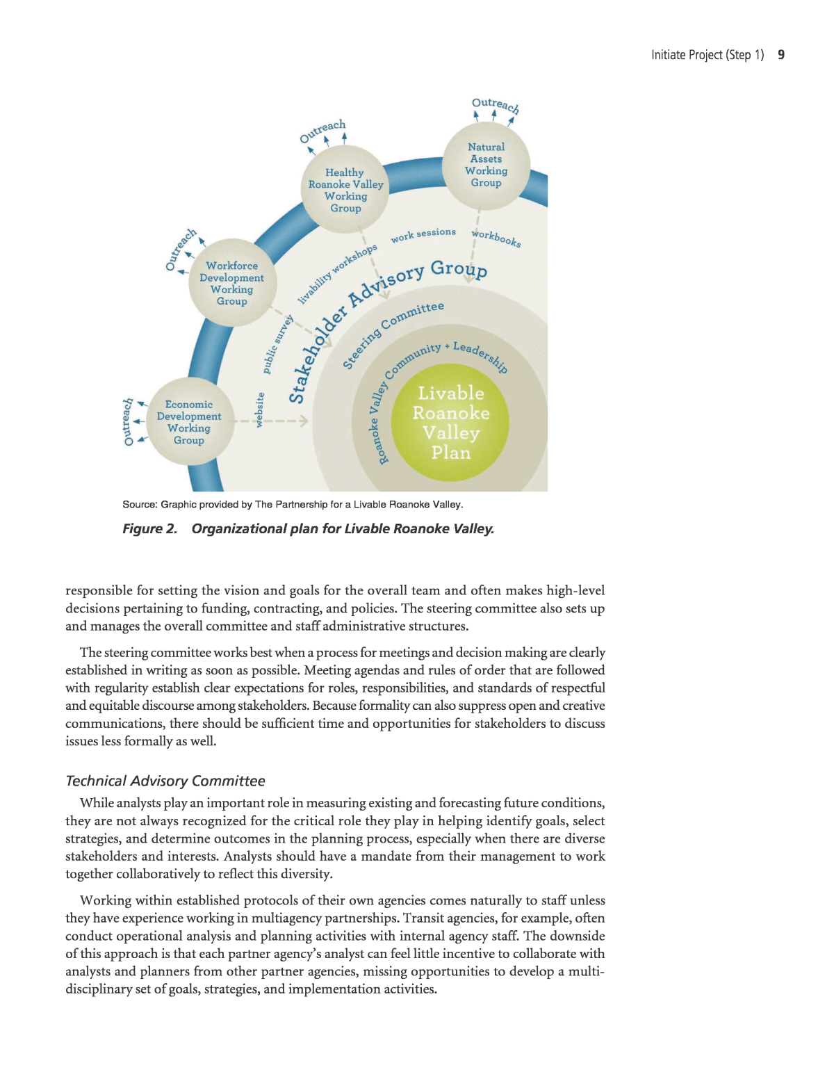
8 Livable Transit Corridors: Methods, Metrics, and Strategies Effective community engagement includes: ⢠Outreach and educationâdisseminating public information and inviting broad-based participation. ⢠Community assessmentsâunderstanding local issues and aspirations through the eyes of stakeholders (McConville 2013). ⢠Meaningful inputâgiving diverse stakeholders meaningful opportunities to influence and shape decision making. For more discussion, see Appendix C. Organize the Stakeholder Team Get organized as soon as possible. Stakeholders generally volunteer their time (either as indi- viduals or as paid representatives of other organizations with other duties) so it is important to make the most of their involvement, quickly building momentum toward action. Since transit corridor livability initiatives generate the most benefits when they effectively address a wide range of issues and topics, the team or organization created should reflect the diversity of backgrounds stakeholders bring as well as the diversity of disciplines the livability initiative will address. It also is important not to take on too much, thus losing focus and wasting limited planning resources. The complexity of the team depends on the scope of the transit corridor livability vision, the levels of interest and motivation stakeholders have for the effort, and the resources available. For example, limited funds available for developing Los Angelesâs âOrange Line BRT [bus rapid transit] Corridor Improvement Planâ necessitated creating a team that mostly concentrated on transportation, land use, and urban design interventions. This focused scope and vision was reflected in the makeup of their planning team, which was limited to stakeholders with interests and capabilities in these areas. Formal establishment of the corridor stakeholder group as a legally recognized entity may be desirable when the team has some combination of the following expectations: ⢠Long-term dedicated and dependable revenue streams available for the planning and implementation efforts. ⢠A wide scope of planning issues and diversity of disciplines to be addressed and that may require formal relationships between public and private stakeholder organizations. ⢠There is a need for full-time staff and/or contracting authority to hire consultants. Informal team organizations are more typical since they tend to be flexible and less costly to administer. Organizational structures (both formal and informal) for transit corridor and livability teams can range from a single stakeholder team or committee charged with all aspects of planning and strategy implementation to large groups of committees, each focused on particular aspects of the project. Figure 2 illustrates the organizational structure for Livable Roanoke Valley in south- western Virginia. Typical organizational structures include the following committees: ⢠Steering and Oversight. ⢠Technical Advisory. ⢠Issue-based Focus Groups. Steering and Oversight Committee Many livability and transit corridor planning efforts organize their stakeholders within systems of tiered committees under the umbrella of a steering or oversight committee. This entity is
Initiate Project (Step 1) 9 responsible for setting the vision and goals for the overall team and often makes high-level decisions pertaining to funding, contracting, and policies. The steering committee also sets up and manages the overall committee and staff administrative structures. The steering committee works best when a process for meetings and decision making are clearly established in writing as soon as possible. Meeting agendas and rules of order that are followed with regularity establish clear expectations for roles, responsibilities, and standards of respectful and equitable discourse among stakeholders. Because formality can also suppress open and creative communications, there should be sufficient time and opportunities for stakeholders to discuss issues less formally as well. Technical Advisory Committee While analysts play an important role in measuring existing and forecasting future conditions, they are not always recognized for the critical role they play in helping identify goals, select strategies, and determine outcomes in the planning process, especially when there are diverse stakeholders and interests. Analysts should have a mandate from their management to work together collaboratively to reflect this diversity. Working within established protocols of their own agencies comes naturally to staff unless they have experience working in multiagency partnerships. Transit agencies, for example, often conduct operational analysis and planning activities with internal agency staff. The downside of this approach is that each partner agencyâs analyst can feel little incentive to collaborate with analysts and planners from other partner agencies, missing opportunities to develop a multi- disciplinary set of goals, strategies, and implementation activities. Source: Graphic provided by The Partnership for a Livable Roanoke Valley. Figure 2. Organizational plan for Livable Roanoke Valley.
10 Livable Transit Corridors: Methods, Metrics, and Strategies To prevent this âsilo effect,â consider forming a collaborative technical advisory subcommittee, staffed by analysts from all relevant stakeholder agencies, to set standards, select methods, and assign analysis work tasks collaboratively. Alternatively, hiring consulting analysts to provide these services, rather than stakeholder agency staff, can also help prevent the silo effect. Focus Groups For broad-scope transit corridor livability initiatives engaging a diverse collection of stake- holders, issues, and strategies, consider creating focus groups (subcommittees) that can target specific themes and issues. Since the areas each group will focus on is best determined after the stakeholders define and adopt a set of Transit Corridor Livability Principles in Step 1.2, guidance on defining and forming focus groups is provided in Step 1.3. Recommended Practice: Organizing the Team Establish a Steering and Oversight Committee and a Technical Advisory Team as soon as possible to create a sense of momentum and purpose for the stakeholders. Define and establish focus groups once the Steering and Oversight Committee has adopted a working transit corridor livability definition. Step 1.2: Develop Stakeholder Transit Corridor Livability Definition Early in the collaborative process, it is important to develop a working definition for transit corridor livability that is agreeable to all stakeholders, but specific enough to guide the visioning and implementation work to come. A working definition will help guide later decisions related to identifying, analyzing, planning, and building livable transit corridors. This Handbook provides a framework for stakeholder groups to define a common understanding of transit corridor livability. This definition has two parts: a transit corridor definition and a definition of livability. While the transit corridor livability definition and its principles were designed to be universally applicable, different stakeholder groups may emphasize or de-emphasize elements of this Hand- bookâs definition based on local values and political realities. However, caution is warranted since the stakeholdersâ working definition and its principles will affect the metrics they use and ultimately shape the corridor strengths and needs they identify. The definition provided in this Handbook comprises six Transit Corridor Livability Prin- ciples based on the Livability Principles developed by U.S.DOT, HUD (Housing and Urban Development), and the EPA (Environmental Protection Agency) (U.S. Department of Housing and Urban Development et al. undated). As shown in Table 2, each Principle is made up of a âPeopleâ and a âPlaceâ factor. Brief descriptions of each Principle and its factors are provided below: ⢠High-Quality Transit, Walking, and Bicycling Opportunities: Opportunities for high-quality transit, walking, and bicycling are distinguished by a combination of non-auto transportation ser- vice quality (the people factor) with urban form characteristics (the place factor). High-quality urban form characteristics can be described as transit-oriented development (TOD) and other compact development patterns that increase the accessibility of people to employment and services without the need for a car. Non-auto transportation service quality characteristics include comprehensive and high-frequency transit services, and complete and direct sidewalk and bicycle facility networks. ⢠Mixed-Income Housing Near Transit: Transit corridors with equitable and affordable housing opportunities have a combination of an economically and age-diverse population (the people
Initiate Project (Step 1) 11 Community Engagement and Equity Planning Strategies Implementation: Corridors of Opportunity in the Twin Cities Community engagement plays a central role in identifying and addressing social and economic needs in less advantaged communities, such as communities with large shares of low-income households and immigrants. In Minneapolis-St. Paul, the Corridors of Opportunity (COO) initiative sought to understand how all kinds of people along a transit corridor define their needs. The initiative emphasized the creation of programs to increase benefits to underserved populations and worked to identify and minimize potential negative impacts. A Housing and Urban Development (HUD) grant made the COO possible and was dedicated to outreach activities administered by community-based organizations doing corridor-level outreach and engagement. Micro-grants were made for outreach activities and emphasized two-way conversations to provide people with real opportunities for input. This led to programs benefiting disadvantaged neighborhoods, including programs for small business development, such as entrepreneurial training, professional skill building, small business loans, and support for identifying and leasing in emerging TOD locations. A grant to a Native American com- munity group led to charrettes and planning activities to change a station area with overpasses and other pedestrian barriers into a place with a net- work of pedestrian-friendly routes and community destinations, such as a farmersâ market. A co-benefit of these community-based planning activities is the expansion of community organization capabilities. Activities built relationships among community organization leaders and public agencies and officials, as community members and organizations have remained involved with COO implementation. Source: Ruch and Partnership for Regional Opportunity: Corridors of Opportunity (2013).
12 Livable Transit Corridors: Methods, Metrics, and Strategies factor) and adequate mixed-income housing (the place factor). Corridors with people from diverse social and economic backgrounds can provide opportunities for residents and visitors to feel kinship within it, while also offering opportunities for people from different backgrounds to mingle, interact, find common ground, and possibly create new community identities in the process. Corridors with adequate mixed-income housing provide housing rental and ownership opportunities that are affordable to people of diverse economic and social backgrounds. ⢠Transit-Accessible Economic Opportunities: Transit corridors with good economic opportu- nities have a combination of high-quality and quantity of consumer opportunities (the people factor) and an ample supply of employment (the place factor). Corridors with high concentra- tions of employment provide transit-accessible means for residents and visitors to earn decent incomes. Corridors with ample consumer opportunities provide retail outlets, both large and small, that offer a competitive consumer marketplace accessible without the need of a car. ⢠Accessible Social and Government Services: The quality, quantity, and accessibility of social and governmental services (both public and private) are important elements in creating a truly livable transit corridor. Livable corridors tend to have high-quality, effective social and govern- ment services (a people factor) that are accessible (the place factor). Corridors with highly accessible services provide high concentrations of health care, social welfare, and government service outlets around transit stations. Corridors with high-quality social and governmental services are distinguished by a high level of coordination between different levels and branches of government and privately run providers, including highly integrated transportation and land uses that use the full capacities of their transit, pedestrian, and bicycling facilities. ⢠Vibrant and Accessible Community, Cultural, and Recreational Opportunities: Transit corridors with vibrant and accessible community, cultural, and recreational opportunities have both numerous and diverse artistic, entertainment, and recreational venues (the people factor) organized in compact, bicycle- and pedestrian-accessible locations near transit (the place factor). ⢠Healthy, Safe, and Walkable Transit Corridor Neighborhoods: The most livable transit corridors also have healthy, safe, and walkable communities near transit nodes and beyond. People in these corridors are encouraged to walk and exercise more when they feel they can do so safe from traffic (the people factor). Pedestrian safety and willingness to walk and bicycle are enhanced when the street network is designed in a pedestrian-oriented fashion, providing a grid street network with the most direct routes possible for people to reach their destinations (the place factor). The more differences between the definition and associated metrics provided in this Handbook and those used by the stakeholders, the more difficult it will be to compare the study corridors to the typology and the metric scores of the corridor cases from around the United States provided herein. Therefore, it is recommended that stakeholders determine the most appropriate transit corridor livability definition for their purposes based in part on the advice of their analysts. Step 1.2.1: Define Your Transit Corridor Travel corridor definitions typically include physical (place) and functional (people) character- istics. Place characteristics such as transportation facilities and urban form are often used to define a corridorâs physical boundaries (Blair 2011, City and County of Denver undated, Porter 2012). The ways people use a corridorâits functional or activity pattern characteristicsâcan also help define boundaries [Smith 1999, Delaware Valley Regional Planning Commission (DVRPC) 2007, Miami Dade County Transit 2011, Reconnecting America and American Public Transit Administration undated]. This Handbook provides a variety of transit corridor definition criteria for analysts to choose from. Most define transit corridor boundaries using both physical and functional characteristics.
Initiate Project (Step 1) 13 A transit corridor consists of a transit alignment (the physical transit line at the center âaxisâ or âspineâ of the corridor), a catchment or buffer area (the width or area of influence of the transit line that extends outward from the corridor alignment), and its length. Some corridors also contain a wide variety of land uses, activity patterns, and travel conditions (among other characteristics) that suggest it should be viewed as a collection of segments. Analysts and stakeholders can consider (but are not limited to) the following criteria to determine a transit corridorâs alignment, catchment, length, and segments. Transit Alignment The transit alignment can be thought of as the axis or spine of a corridor. Beyond this funda- mental criterion, this Handbook leaves the selection of other criteria to the analystâs discretion. However, this Handbook recommends using one, or a combination, of the following criteria for identifying transit alignments. Corridor Service Configuration. The general operating configuration of transit within a proposed or existing corridor generally takes one of two forms: ⢠Fixed-guideway: rail and bus services operate in their own, dedicated guideways. ⢠Mixed-mode: rail and bus services operate in mixed-traffic, general purpose lanes. Transit Mode. A corridor can be centered on a high-capacity transit line or a collection of other fixed-guideway and/or mixed-mode transit lines. The following descriptions are not exhaustive definitions of transit mode types, but a general guide to use when determining what transit alignment is suitable to consider when defining a corridor. More detailed definitions can be found in Urban Transit: Systems and Technology (Vuchic 2007). ⢠Local, express, or rapid bus: a bus line (or collection of bus lines running on a common street) with peak period headways of 10 minutes at most and 20 minutes in the off-peak. ⢠BRT: a line running mostly in a fixed-guideway or a dedicated lane/right-of-way. ⢠Streetcar: electrically powered rail transit running primarily in mixed traffic on city surface streets. ⢠Light rail transit (LRT): an LRT line with continuous service throughout the day, running primarily on a fixed-guideway. ⢠Heavy rail/rapid transit (HRT): a line running exclusively on a fixed-guideway with continuous service throughout the day. ⢠Commuter rail (CR): a line with continuous service throughout the day and average station spacings no greater than 5 miles. This Handbook considers CR lines with station spacing longer than 5 miles to provide insufficient coverage of service to its interstation areas for consideration of livability impacts. Transit Level of Service Provided. Select the transit alignment based on the identification of the transit route/line with the highest frequency and/or extent of service provided in the area of interest. Length Determining the best length for a corridor can be tricky because long corridors have more varia- tion of characteristics (land uses, activity patterns, and travel patterns), while short corridors may not include enough of both trip origins and destinations (see Internal Capture subsection below). In other words, a corridor needs to be long enough to be relatively self-contained [containing enough origins (housing) and destinations (employment)] without being so long that it varies in character significantly over its length. While a very long corridor may capture more of its
14 Livable Transit Corridors: Methods, Metrics, and Strategies daily trips internally (containing both origins and destinations) and therefore may yield higher livability metric scores in some cases, the analyst will miss identifying critical shortcomings and needs in subsections of the corridor that are masked by its sheer size. Analysts might consider breaking up very long corridors into segments that can be evaluated separately or combined for analysis as a single unit, depending on their needs. It is strongly recom- mended that whatever criteria chosen to determine length, the corridor should NOT include Virginiaâs Orange Line Corridor: An Early Example of Transit Corridor Planning Metropolitan Washington, D.C.âs Orange Line (Rosslyn-Ballston) Corridor is an early, successful example of corridor-level TOD planning. In the 1960s, county officials successfully lobbied to change the planned alignment of the Metro line, moving it away from its planned above-ground route parallel to Interstate 66 (where it would bypass established commercial centers) to an underground align- ment with stations at key activity centers. The extensive planning efforts that followed are an early example of corridor-level TOD coordination across jurisdic- tional boundaries that directed high-density development to station areas with what they termed the âbulls-eye approach.â This approach targeted the highest- density development within a quarter-mile of stations, with intensities tapering off at further distances (Figure 3). Source: Courtesy of Arlington County Government (undated). Figure 3. Washington, D.C.âs Rosslyn-Ballston corridor âbullâs eyeâ concept plan.
Initiate Project (Step 1) 15 corridors with stations BOTH within and outside of central business districts (CBDs) (see CBD discussion below). Otherwise, consider selecting from the following criteria when determining corridor length. Minimum Number of Stations. A corridor will have at least three consecutive stops or stations. Otherwise, there is no lower limit on the measured length of the transit line. Internal Capture. A trip between end points should be of practical length for normal daily activities; that is, a corridor captures a substantial portion of origins and destinations of trips within it. Internal capture can be evaluated based on the local knowledge and judgments of the analysts or using a more quantitative approach. Quantitative approaches use travel survey data to identify trip ends and calculate the standard deviation of trips that begin and end within similar corridors from the region, state, or nation. Corridor lengths that include both trip ends within one standard deviation (or two depending on the preferences of the analyst) of total corridor trips with both origins and destinations within its boundaries could be considered to have sufficient internal capture. Table 3 provides internal capture means and standard deviations for a sample of transit corridors in California, Texas, and Florida. As discussed above, the analyst needs to be aware that longer corridors will yield greater levels of internal capture, but also contain significant variations in built form and travel patterns that may be best analyzed as separate segments. Similarly, short corridors will have more consistent characteristics internally, but may not be long enough to contain sufficient numbers of origins and destinations. The analyst must balance these competing needs using professional judgment and local knowledge of the corridor and how it functions. Catchment Area Consider the following criteria to determine a corridorâs catchment area (width). Maximum Reasonable Walking Distance. The width of a study corridor is a uniform distance as determined by the existing transit access research literature (such as 1 mile from high-capacity transitâincluding BRTâand ½ mile from each local, express, or rapid bus line alignment, as used for this Handbookâs research). Station Access Travel Patterns. Using station access survey data (most likely collected by the transit agency operating the corridorâs transit services), the corridorâs catchment can be defined by mapping the trip origins and destinations within one standard deviation (or two, depending on the analystâs preference) of distance to the nearest transit station, compared to other corridors from the region, state, or nation. Alternatively, the method described above for determining length by calculating internal capture rates using travel survey data could be used. Corridor Internal Capture Values (All Modes and Trip Types) Outside of CBD 63.2% 15.0% Inside of CBD 58.7% 20.6% Corridor Type Mean (l) (r) Standard Deviation Table 3. Internal capture (all modes and trip types) mean and standard deviation values for transit corridors.
16 Livable Transit Corridors: Methods, Metrics, and Strategies Land Use Patterns. Using qualitative or quantitative assessment methods of the study corridorâs land uses, identify a corridorâs boundaries so it includes both residential areas (origins) and activity centers (destinations). Travel Market Potential. Direct ridership models, travel demand forecasting models, and other ridership projection methods can be used to identify the travel market potential for a proposed transit alignment and its surrounding corridor. CBDs CBDs are important components of livable transit corridors. A transit corridor that provides quick and convenient access to a vibrant CBD will be highly livable. However, as discussed pre- viously, it is strongly recommended that whatever criteria the analyst chooses for determining length, the corridor should NOT include stations both within and outside CBDs since these areas are often substantially different from one another. If CBD station areas are included in a corridor that also includes station areas outside the CBD, the CBDâs livability opportunities will likely dominate the metric scores of the entire transit corridor. As a result, analysts may inadvertently overlook the livability strengths and needs in the non-CBD areas of the corridor. Corridors that are entirely within a CBD can be analyzed separately (and with caution) using this Handbookâs methods and metrics. However, the statistical analysis performed to develop these methods and metrics used data from corridors outside of CBDs. Therefore, while the same concepts underpinning this Handbookâs methods and metrics should apply to transit corridors inside of CBDs, CBDs are unique urban places with their own transportation and land use dynamics, and therefore the authors of this Handbook strongly urge analysts to use these methods with caution and to primarily rely on their own (and those of other stakeholders) professional judgments and knowledge of transit corridors within CBDs. Segments A corridor can be broken up into segments based on several criteria. Each segment can be analyzed separately or combined for analysis as a whole, depending on the needs of the stake- holders and analysts. The following criteria can be considered for identifying corridor segments. Station-to-Station Travel Patterns. Use boarding and alighting data for the transit alignmentâs stations/stops to identify groups of stations (segments) that are primarily trip origins (residential) and those that are primarily trip destinations (activity centers). Land Use Patterns. Assess the corridor qualitatively or quantitatively to group station areas with similar land use patterns into common corridor segments. Bostonâs Orange Line Corridor: Identifying Distinct Corridor Segments Bostonâs Orange Line corridor plays a critical role in the region. Roughly one-quarter of the regionâs residents and 300,000 jobs are located near one of the Orange Lineâs 20 stations. The character of the corridor is diverse, ranging from dense, jobs-rich downtown Boston (the Central segment), to mixed commercial-residential areas of the north segment, to the largely residential areas along the south segment. The Orange Lineâs planners recognized these distinct corridor segments early in the process of creating their corridor plan, and analyzed them individually as well as at the station and corridor levels (see Figure 4).
Initiate Project (Step 1) 17 Jurisdictional Boundaries. Use city, service area, or other jurisdictional boundaries to create corridor segments. Caution is recommended since jurisdictional boundaries often are irrelevant in terms of the functional characteristics of a corridor and the ways people use them. Step 1.2.2: Define Livability for Your Corridor Livability is about access to quality-of-life opportunities. The most livable communities offer numerous and diverse opportunities (choices) for people to improve the quality of their lives. Figure 5 illustrates how people convert livability opportunities into quality-of-life outcomes in a transit corridor. Opportunities come in many forms, and peopleâs ideas of what makes a community livable are often different. A useful livability definition must be general enough to be inclusive. This Handbookâs livability definition seeks to accommodate as many different perspectives as pos- sible and says that livability occurs when people have good access to opportunities they can use in the pursuit of improvements to their quality of life. Source: Metropolitan Area Planning Council (2013). Figure 4. Bostonâs Orange Line analysis segments with existing land uses.
18 Livable Transit Corridors: Methods, Metrics, and Strategies A definition must also be specific enough to be useful. Without specificity, measurement and implementation become difficult, if not impossible. This Handbookâs definition is also based on the Partnership for Sustainable Communitiesâ Livability Principles (U.S. Department of Housing and Urban Development et al. undated) (and other definitions found in the literature) to identify and evaluate key livability opportunities, thereby making it as specific as possible. Based on the Partnershipâs principles, this Handbook offers a set of Transit Corridor Livability Principles. These principles state that a livable transit corridor provides accessibility to oppor- tunities and choices including (1) high-quality transit, walking, and bicycling opportunities; (2) mixed-income housing near transit; (3) transit-accessible economic opportunities; (4) vibrant and accessible community, cultural, and recreational opportunities; (5) accessible social and government services; and (6) healthy, safe, walkable transit corridor neighborhoods. A compari- son of the Transit Corridor Livability Principles above and those developed by the Partnership for Sustainable Communities was shown in Table 1. The definition and principles used in this Handbook are based on the hypothesis (generated from a review of the existing literature) that transit corridor opportunities are composed of both people and place opportunities. People and places are two key themes found in many livability definitions. People and places interact with each other to create opportunities for corridor residents, workers, and consumers to improve quality of life for themselves and their families (Puget Sound Regional Council 2012). Livability enhances quality of life by enhancing people and place opportunities. Table 4 identifies key people and place opportunities (factors) for each of this Handbookâs principles based on concepts found in the livability literature. This can help analysts and decision makers identify and measure how these ideal characteristics interact to provide transit corridor livability opportunities in their corridors. People and place factors can interact to create more opportunities than the sum of their parts. Figure 6 illustrates how these factors can combine to affect the livability opportunity outcomes in a transit corridor. Each factor is discussed in terms of high and low levels of transit corridor opportunities (Puget Sound Regional Council 2012). Specific combinations of these charac- teristics and the degree to which they reinforce each other also help determine transit corridor livability. For example, Figure 7 illustrates how transit-oriented urban form (a place factor) provides a diverse set of land use and urban design qualities that canâunder the right circumstancesâ interact with and reinforce a diverse set of travel options, including high-quality transit, walking, and bicycling services (a people factor). In this simplified diagram, each pairing of a people and place factor creates a set of four combinations with varying transit, walking, and bicycling opportunities. Each corridor can be assessed according to these opportunities and classified as one of the four descriptions shown in Figure 7. Figure 5. People convert livability opportunities into quality-of-life outcomes.
Initiate Project (Step 1) 19 Transit Corridor Livability Principles Factor Category Factor Name High-quality transit, walking, and bicycling opportunities Place Urban form (transit employment accessibility) People Transit and non-auto service quality Mixed-income housing near transit Place Mixed-income housing People Economically and age-diverse population Transit-accessible economic opportunities Place Employment opportunities People Consumer opportunities Vibrant and accessible community, cultural, and recreational opportunities Place Urban form (residential density) People Cultural and recreational opportunities Accessible social and government services Place Accessible services People Effective services Healthy, safe, walkable transit corridor neighborhoods Place Pedestrian-oriented environment People Neighborhood safety Table 4. People and place factor components of transit corridor livability. Figure 6. People and place factor interactions. The darkest box (the upper-right quadrant) represents the most livable corridors, as they have the most diverse transit, walking, and bicycling opportunities (people factor) and a diverse set of land use activities (place factor), as might be found in TOD. Therefore, livability opportunities are generated not merely by the diversity of people or place opportunities in isolation, but by their interactions. More extensive discussion of the other people and place interactions for the other Transit Corridor Livability Principles is provided in Appendix D.
20 Livable Transit Corridors: Methods, Metrics, and Strategies Recommended Practice: Choosing Transit Corridor Livability Definitions Develop definitions for your transit corridor (boundaries) and livability in collaboration with stakeholder decision makers, planners, and analysts, blending local values, aspirations, and context with the definitions provided in this Handbook. If there are previous planning studies for your corridor that define the boundaries or livability differently (for example, with a buffer of two miles instead of one around the transit line), then your stakeholders will need to deter- mine how important it is that the current study you are undertaking is consistent with these previous definitions. It is important to remember that the more differences there are between your definitions and those outlined in this Handbook, the more difficult it will be to use this Handbookâs methods to guide your selection of goals and strategies. Therefore, consider carefully how much the methods and definitions you select differ from those provided in this Handbook. If comparison to the national transit corridor metric baselines provided in this Handbook is an important part of the stakeholdersâ analytic and collaborative processes, then aim to minimize the definitional and methodological differences between those provided herein and those selected for use. Step 1.3: Organize and Establish Focus Groups Consider organizing a set of focus groups composed of interested stakeholders with appro- priate expertise, with each focus group designed around the Transit Corridor Livability Prin- ciples adopted by the stakeholders in Step 1.2. These principles can be made into clear, concise mission statements for each focus group. Over the course of the planning and implementation process, each group can adopt a set of goals and strategies that clearly articulates their mission (as determined by their assigned principle) and the means to achieve them. Figure 2 shows how Livable Roanoke Valleyâs focus groups fit into their larger organizational structure. In the San Francisco Bay Area, Alameda Countyâs Eden Area Livability Initiative designed Figure 7. Urban form (place) and transit/non-auto service quality (people) factor interactions.
Initiate Project (Step 1) 21 Defining Livability in Practice: Partnership for a Livable Roanoke Valley The Roanoke Valley in southwestern Virginia (including Roanoke City and Salem) has developed a set of livability initiatives based on a definition that reflects community values and aspirations. Facing a number of social and economic challenges, the Roanoke Valley-Alleghany Regional Commission and the Council of Community Services created the Partnership for a Livable Roanoke Valley in 2011. In a two-year-long visioning and planning process, these partner agencies engaged the wider community in a process to articulate a vision, principles, goals, and strategies for improving livability in their region. The eight Livability Guiding Principles, listed below, are written in language specific to their community, but the themes are familiar and compare well to the Partnership for Sustainable Communitiesâ Livability Principles outlined in Table 2. ⢠Protect the beauty and ecology of the Roanoke Valley. ⢠Provide a healthy and equitable quality of life for all of our citizens. ⢠Celebrate the diversity of our region and its contribution to our culture. ⢠Embrace both our traditions and new innovations to create economic vitality. ⢠Anticipate and adapt to change with responsible leadership. ⢠Build on the assets of our local communities to strengthen our regional collaboration. ⢠Invest in regional infrastructure improvements that meet the communitiesâ needs of the 21st century. ⢠Promote excellence in education, job training, and a culture of lifelong learning. While this Handbook separates definition/principles from goals and strategies for the sake of clarity, Livable Roanoke Valleyâs articulation of a set of actionable and measurable principles, goals, and strategies based on local values and aspirations provides a solid foundation for the multiagency, multisector partnership process. Sources: Roanoke Valley-Alleghany Regional Commission (2015a and 2015b). Designing Livability Principle-Based Focus Groups: San Francisco Bay Areaâs Eden Area Livability Initiative The Eden Area Livability Initiativeâs working (focus) groups are designed and organized to address the key themes of interest to and expertise of community stakeholders. ⢠Agriculture and Environment Working Group: Provides educational opportunities in the school system and surrounding community about agriculture (farming, ranching, and equestrian) while seeking park and open space opportunities in the urban built out environment. ⢠Economic Development Working Group: Promotes private economic investment in Eden Area and attracts both businesses and customers. ⢠Education Working Group: Advocates and provides avenues for increasing resources and opportunities for all schools and students in the Eden Area. ⢠Governance Working Group: Enhances local self-governance. ⢠Public Safety and Realignment Working Group: Establishes guidelines and protocols regarding licensed and unlicensed housing establishments such as group homes, care facilities, halfway houses, and other therapeutic treatment facilities to ensure quality of service and safety of the community and program residents. Works to prevent crime and reduce recidivism. Source: Eden Area Livability Initiative (2015).
22 Livable Transit Corridors: Methods, Metrics, and Strategies their processâincluding five working (focus) groupsâwith the goal âto encourage planning and action across disciplines and interest areas.â This diversity of stakeholders and interests is reflected in the focus groups they formed and in the text of each groupâs goal statements (Eden Area Livability Initiative 2015). Recommended Practice: Establishing Focus Groups Establish focus groups to oversee the planning and implementation of each of the stakeholdersâ Transit Corridor Livability Principles. Table 5 provides a list of recommended focus groups designed to address each Transit Corridor Livability Principle. The names and goals of each group are subject to stakeholder preferences and needs, and should be tailored to directly address the principles articulated by the stakeholders. Handbookâs Transit Corridor Livability Principles Recommended Focus Groups High-quality transit, walking, and bicycling opportunities Transportation and land use coordination Mixed-income housing near transit Affordable and equitable housing Transit-accessible economic opportunities Economic opportunities development Vibrant and accessible community, cultural, and recreational opportunities Culture and recreation Accessible social and government services Social and government services Healthy, safe, walkable transit corridor neighborhoods Safe and healthy neighborhoods Table 5. Recommended focus groups according to Handbookâs Transit Corridor Livability Principles.
