
The Federal Emergency Management Agency’s (FEMA) Federal Insurance and Mitigation Administration1 manages the National Flood Insurance Program (NFIP), which is a cornerstone in the nation’s strategy to assist communities in preparing for and recovering from flood disasters. The NFIP was established by Congress with passage of the National Flood Insurance Act in 1968, because despite the nation’s efforts to address flood hazards through construction of civil engineering works such as dams, levees, and floodwalls and seawalls, flood losses were rising and unwise development within floodplains was continuing. The Act was passed to reduce future flood damages through implementation of community floodplain ordinances that would control development in flood hazard areas, provide flood insurance for a premium to property owners, and, as a result, reduce federal expenditures for disaster assistance. The flood insurance is available only to owners of insurable property located in communities that participate in the NFIP.
Today, most of the nation’s communities with significant flood hazards have joined the NFIP. Currently, the program has approximately 5,555,915 policies2 in 21,881 communities3 across the United States (Siamak Esfandiary, FEMA, personal communication, February 2013). Although community participation is voluntary, communities must agree to a floodplain management ordinance that requires that new buildings be built at or above the level of the one percent annual chance flood.4 In turn, FEMA will issue Flood Insurance Rate Maps (FIRMs) and make flood insurance available throughout the community (FEMA, n.d.).
A key feature of the NFIP is that structures in areas within a community that are determined to be located within the one percent annual chance flood (100-year or base flood) floodplain are referred to as being within the Special Flood Hazard Area (SFHA) (Box 1-1). These areas are subject to mandatory flood insurance purchase requirements.
The SFHA is delineated on FEMA’s FIRMs using topographic, meteorologic, hydrologic, and hydraulic information. It is difficult to estimate the degree of exposure to flood risk in the United States. FEMA currently estimates that 6.5 percent of U.S. housing units, or 5.8 percent of the population, are located in SFHAs, which equates to about 7.3 percent of the nation’s area (Table 1-1).
Levees and floodwalls, hereafter referred to as levees, have been part of flood management in the United States since the late 1700s because they are relatively easy to build and a reasonable infrastructure investment. A levee
_______________
1 See http://www.fema.gov/what-mitigation/federal-insurance-and-mitigation-administration-fima#0.
2 As of December 2012.
3 As of June 2012.
4 The requirements related to this ordinance are found in Title 44 of the Code of Federal Regulations, including Parts 59 and 60.
BOX 1-1
One Percent Annual Chance Flood
One percent annual chance flood, base flood, and the 100-year flood, are terms commonly used to describe a hydrologic event that has a 100-year (average) recurrence interval, that is, a flood that has in any year a 1 in 100 chance of being equaled or exceeded. The National Flood Insurance Program (NFIP) refers to properties in the one percent annual chance floodplain as those in the Special Flood Hazard Area. An illustration showing the impact of a one percent annual chance flood on a natural floodplain with various levee heights is shown in Figure 1-1. Over the lifetime of a 30-year mortgage, this equates to at least a 26 percent chance that the property will be flooded if the property is in the one percent annual chance floodplain. Probability theory is used to derive the value 26 percent, where each of the 30 years is accounted for as having a one percent annual chance flood (USGS, 2010.)
Similarly, hydrologic events of any size are described using the same nomenclature, for example, the “50-year” or “500-year” describing events that have a 1 in 50 chance or 1 in 500 chance of occurring (2 percent annual chance flood and 0.2 percent annual chance flood, respectively). Levees are also classified in the same way; that is, a 100-year levee is of adequate height to withstand the one percent annual chance flood.
There is a degree of interchangeability in general use of these terms. However, the use of certain recurrence interval terms, such as the “100-year flood,” can cause confusion because it is interpreted as a flood that occurs once every 100 years (USGS, 2010).
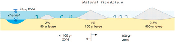
FIGURE 1-1 Illustration of the one percent annual chance flood (Q100) and the impact on a natural floodplain with various levee heights.
is a “man-made structure, usually an earthen embankment, designed, and constructed in accordance with sound engineering practices to contain, control, or divert the flow of water so as to provide protection from temporary flooding.”5 Levees are generally designed to control water up to a given water elevation and, unlike dams, levees do not typically have spillways to reduce structural damages when water levels exceed the design criteria and overtop the structure (Box 1-2). A levee system is a “flood protection system which consists of a levee, or levees, and associated structures, such as closure and drainage devices, which are constructed and operated in accordance with sound engineering practices.”6 Under NFIP regulations, homes and commercial buildings located in the SFHA
_______________
5 See Code of Federal Regulations, Title 44, Section 59.1 (44 CFR §59.1).
6 See 44 CFR §59.1. An expanded definition of a levee system, adapted from the National Committee on Dam and Levee Safety, is as follows: A levee system comprises one or more components that collectively provide flood risk reduction to a defined area. Breach or malfunction of one component within a system constitutes breach or malfunction of the entire system. The levee system is inclusive of all components that are interconnected and necessary to ensure exclusion of floodwaters from the associated leveed area. The leveed area may also be considered as the associated separable floodplain or separable consequence area. Structures and features include levee and floodwall sections, closure structures, pumping stations, culverts, interior drainage works, and other structures and features, such as highway and railroad embankments that function as components of the system whether or not intentionally constructed as part of the system.
TABLE 1-1 National Special Flood Hazard Area (SFHA) Population, Housing Units, and Square Miles Distribution
| Total in SFHA | Total Outside SFHA |
Total National | |||
| Coastal | Riverine | Total | |||
| Population within SFHA (million) | 6.9 | 11.3 | 18.2 | 294.2 | |
| National percentage population in SFHA | 2.2 | 3.6 | 5.8 | 94.2 | 312.4 |
| Housing units within SFHA (million) | 3.8 | 4.9 | 8.6 | 124.7 | |
| National percentage housing units within SFHA | 2.8 | 3.7 | 6.5 | 93.5 | 133.3 |
| Area within SFHA (square miles) | 42,677 | 222,621 | 265,299 | 3,375,949 | |
| National percentage area in SFHA | 1.2 | 6.1 | 7.3 | 92.7 | 3,641,247 |
SOURCE: RAMPP (2012).
BOX 1-2
Use of the Word “Protection”
In the literature, the word “protection” is often used to describe a levee that “protects” against a one percent annual chance flood. For example, from 44 CFR §65.10 when describing levee design criteria, “For levees to be recognized by FEMA, evidence that adequate design and operation and maintenance systems are in place to provide reasonable assurance that protection from the base flood exists must be provided.” This type of language leads to the inaccurate conclusion that levees are “safe” and protect, without fail, to the one percent annual chance flood. However, all levees, even accredited levees, can fail or be overtopped—that is, achieving zero risk is not a possibility. Thus, in trying to make areas safer, in reality, the potential for catastrophic losses is increased (Burby, 2006).
The use of the word protection is unavoidable in discussion of levee-related flood risk. However, it is important to keep in mind that although levees do offer “protection” from floodwaters, they only separate the area behind a levee from floodwaters until the point where the levee fails or is overtopped.
within a participating community may be exempted from the mandatory purchase requirement and land-use regulations when located behind a levee system that has been recognized by FEMA as providing protection against the one percent annual chance flood event, that is, accredited.
For a levee system to gain accreditation status, a community or other party must submit an accreditation package to FEMA (Figure 1-2). This package includes certification by a registered Professional Engineer (P.E.) or federal agency with responsibility for levee design that the levee system has been adequately designed and constructed to provide protection against the base flood according to the structural requirements of the FEMA criteria as found in Title 44, Section 65.10 of the Code of Federal Regulations (44 CFR §65.10; see Appendix A of this report for the full text of this regulation). Accreditation also requires an operation plan and a maintenance plan for the levee system, the details of which are also found in 44 CFR §65.10. FEMA’s Procedure Memorandum 63, Guidance for Reviewing Levee Accreditation Submittals, discusses the process of review for compliance with 44 CFR §65.10 and accreditation (FEMA, 2010).
Levees can provide some flood control benefits that range from minor to substantial. For example, during record-setting floods in 2011, the levee system on the Lower Mississippi River was credited with preventing over $110 billion dollars in damages to the lands behind them (MRC, 2011). At the same time, no levee can provide absolute protection against all floods and failures of levee systems, such as those that occurred during Hurricane Katrina, which can cause billions of dollars worth of damages and threaten lives. All levees are subject to struc-
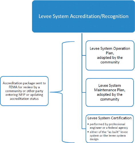
FIGURE 1-2 FEMA’s levee system accreditation/recognition process.
NOTES: Recognition is used in parallel with accreditation in 44 CFR §65.10; design criteria for levee systems to be recognized by FEMA are provided in 44 CFR §65.10(b)(1)-(7).
tural failure. Thus, there are always risks to property, infrastructure, and inhabitants located behind levees, that is, residual risk (Box 1-3).7
The concept of residual risk behind levees confounds and complicates many public policy and investment decisions. For example, a levee may provide benefits in the form of flood damages prevented, but such benefits must be balanced against the costs of building and maintaining a levee and the potential costs of a levee being overtopped or failing. If a levee is capable of controlling the water flow of the one percent annual chance flood event, there is still a 26 percent probability that the levee will be overtopped at least once in the next 30 years. There is also some probability that the levee will not maintain its structural integrity as the flood waters rise against it, or that because of poor maintenance or operation it will not function as designed. Also, initial levee construction may have been faulty.
Moreover, residual risk generally changes over time with changes in land-use patterns, development, and hydrologic variability. If development behind a levee substantially increases, the consequences of a levee failure or overtopping will also substantially increase. If development upstream of the levee site increases, the rainfall
_______________
7 Overtopping is the condition that occurs when floodwaters exceed the levee height. Levee failure is when the design component of a levee is reached. Overtopping and failure occur in a variety of scenarios related to the performance of the levee, including breach before or after overtopping, overtopping without a breach, and malfunction of system components (e.g., gates, pumping plants, or floodwalls). These scenarios result in different degrees of inundation, with failure causing the most severe flooding.
BOX 1-3
Risk, Residual Risk, and Uncertainty
Many definitions of risk (i.e. disaster risk) exist in the literature (Peduzzi et al., 2009; IPCC, 2012; NRC, 2012). A broad definition of risk is adopted in this report when dealing with physical hazards and their consequences. Risk is the potential for adverse effects from the occurrence of a particular hazardous event, which is derived from the probable combination of physical hazards (physical characteristics), the exposure and vulnerabilities of people and property subject to danger or damage from the hazard, and the consequences (impact or damage) caused by the hazard. In the context of this report, the physical hazard discussed is flooding.
Note, however, that in insurance nomenclature, risk is the term used to designate the loss consequence of the realization of the uncertain peril, and it may be financial or nonfinancial in nature (e.g., reputational loss). The cause of loss is called a peril, and a condition or situation that increases either the likelihood or severity of the peril occurring is called a hazard. This latter definition is used in Chapter 5 in discussing insurance rating.
Similarly, many definitions of residual risk exist in the literature (USACE, 2006; UNISDR, 2009). A broad definition of residual risk is adopted in this report. Residual risk is the risk that remains after considering the mitigating effects of structural, nonstructural, and other risk reduction measures. Residual risk is always present behind a levee, because no levee is fail-safe.
Determination of risk requires analyses that are dependent on knowledge of the factors that influence the risk. There is uncertainty connected with the definition of these factors. A 2010 National Research Council committee examining risk for the Department of Homeland Security found that
uncertainty is always present in our ability to predict what might occur in the future, and is present as well in our ability to reconstruct and understand what has happened in the past. This uncertainty arises from missing or incomplete observations and data; imperfect understanding of the physical and behavioral processes that determine the response of natural and built environments and the people within them; and our inability to synthesize data and knowledge into working models able to provide predictions where and when we need them. (NRC, 2010)
The specific nature of the elements of uncertainty are examined in detail in Chapter 3.
runoff into the river and the level of the flow increase. An additional challenge to federal, state, and local officials is that the concept of residual risk behind levees causes confusion for residents living or working behind levees. Because areas behind the 100-year levee are not shown on FIRMs as subject to the one percent annual chance flood and residents are not subject to the MPR, many residents assume that they are protected against all flooding, not just the one percent annual chance flood.
Stationarity is the idea that hydrologic systems fluctuate in an unchanging envelope of variability. Water management systems have been designed on the basis of this assumption throughout the world (Milly et al., 2008). However, factors such as climate change, land use, and demographic change impact the water cycle and are causing the Earth’s hydrologic system to depart from the historical behaviors (NRC, 2011). Changes in hydrology could dramatically change exposure to flood risk. Furthermore, nonstationarity means that the elevation of the one percent annual chance flood will change over time. For programs based on the one percent annual chance flood, this has the potential to cause conflict and confusion.
In 1982, the NRC issued a FEMA-sponsored report regarding levee policies for use in administering floodplain management, insurance, and risk mapping aspects of the NFIP (NRC, 1982). The report’s recommendations were taken into account in 1986 when requirements for levee system accreditation were established (44 CFR §65.10; see Appendix A). The regulations focus on requirements that must be met if a community or levee owner requests that a levee system be recognized on the NFIP FIRMs.
The most recent mapping techniques for accredited and not accredited levees were developed and published in 2002 (FEMA, 2002). During its Map Modernization Program or “Map Mod,”8 funded for fiscal years 2003 to 2008, FEMA determined that analysis of the role of levees in flood risk reduction would be an important part of the effort and noted that the status of the nation’s levees was not well understood and the condition of many levees had not been assessed since their original inclusion in the NFIP, if at all. FEMA also learned that a large number of accredited levees might no longer meet the requirement of 44 CFR §65.10 because of either structural deficiencies or insufficient information on which to base continued compliance with regulatory requirements. Deaccrediting a number of large levees that were previously accredited and making distinctions between a levee versus road or railroad embankments that have served as part of the levee system are topics with significant social and political ramifications and are top priorities for FEMA.
Recognizing the need for improving the risk assessment and mapping techniques for areas behind levees, improving regulations governing levees in NFIP, raising public awareness of the levee risk, and enhancing institutional relationships, FEMA officials approached the NRC Water Science and Technology Board and requested the present study. The NRC responded by forming the ad hoc Committee on Levee and the National Flood Insurance Program: Improving Policies and Practices (Appendix B). The committee’s charge was to examine current FEMA treatment of levees within the NFIP and provide advice on how those levee-related policies and activities could be improved. The study addressed risk analysis, flood insurance, risk reduction, and risk communication regarding how levees are considered in the NFIP (Box 1-4).
This report offers conclusions and recommendations to improve the science and engineering behind the NFIP’s treatment of levees. Often, nonscientific issues are integral to solving challenging questions such as those captured in the statement of task for this report, for example, available resources; social and cultural values; and a variety of federal, state, and local regulations and laws. Defining and adhering to the boundary between science and engineering and policy is challenging for scientists, decision makers, and stakeholder groups. There is a role for science and engineering to inform policy decisions, a role that is explored in this report.
The NFIP offers insurance to all property owners in communities that participate in the program regardless of where the property is located. This includes properties behind levees and those not behind levees but within the SFHA. This also includes geographic areas that are vulnerable to flooding that might extend beyond the SFHA. This report provides guidance on FEMA’s treatment of levees in the NFIP, considering risk analysis, risk reduction, insurance rates, and risk communication. Many of the issues covered in this report are not limited to managing property and life risk behind levees—FEMA grapples with these issues throughout the SFHA and often beyond. Thus, some of the content of this report can be extended throughout both the SFHA and the surrounding floodplain despite the fact that it was written within the framework of levees. The report explicitly states when observations relate to the SFHA, rather than just the area behind levees. The report also distinguishes between the SFHA and the floodplain at large, when appropriate.
Despite relevance to the report, providing specific advice on some topics was determined to be outside of the scope of the statement of task. For example, the report does not provide conclusions or recommendations related to the appropriateness of the current standard for the NFIP (i.e., the base flood elevation or the one percent annual chance flood event). However, the report does provide perspective on the current view of this standard in the scientific literature and identifies efforts to utilize alternative standards. The report also does not specifically address fiscal issues associated with construction, maintenance, and upgrades of levees within the NFIP, other than to identify where such issues may arise. The report does not address the subjects of fiscal responsibility for disaster
_______________
8 Map Mod was a 5-year program to modernize FEMA flood maps by converting from paper to digital format and updating out-of-date maps, when possible. Map Mod is discussed further in Chapter 2.
BOX 1-4
Statement of Task
An ad hoc committee will examine current FEMA treatment of levees within the National Flood Insurance Program, and provide advice on how those levee-related policies and activities could be improved. The study will address the following topics regarding how levees are considered in the NFIP: (1) risk analysis, (2) flood insurance, (3) risk reduction, and (4) risk communication. More specifically, within this framework the committee will consider the following key issues and topics:
(1) RISK ANALYSIS
• Current risk analysis and mapping procedures and guidelines of levees implemented to determine risk premium rate zones for flood insurance purposes.
• Existing Special Flood Hazard Areas (SFHA) and their corresponding risk premium rates for areas behind accredited and non-accredited levees.
• Existing requirements for levee accreditation under 44 CFR §65.10.
(2) FLOOD INSURANCE
• Flood insurance pricing options for areas behind levees.
• Direct annualized flood loss estimates for residential and commercial structures behind levees.
• Waiving mandatory flood insurance purchase requirements for areas behind accredited levees.
(3) RISK REDUCTION
• Floodplain management, building standards, and land use practices employed behind levees across the nation.
• Engineered overtopping and breaches as a risk reduction or mitigation measure for levee systems.
• Existing and proposed levee-related grants and personal assistance policies. How can communities maximize benefits and reduce risks by using these?
• Mitigation options for communities with levees to help offset risks as investments grow in them and in areas behind levees
(4) RISK COMMUNICATION
• Existing FEMA levee outreach activities, programs, and material.
• The concept of “shared responsibility” for flood risk management and how it might be promoted.
• Incentives for communities to participate in mitigation activities that reduce levee-related risks.
• Non-regulatory products that can complement regulatory products in terms of risk communication.
The study and report will examine the efficacy of these practices and policies, make observations regarding levee policies, and analyze options for improving FEMA’s treatment of levees within the National Flood Insurance Program. All conclusions and recommendations will be grounded in physical and social science and engineering concepts and evidence.
assistance or the relationship between federal disaster assistance and flood insurance, flood damage mitigation, or “affordability” of levees for a community.
In the course of deliberations and information-gathering efforts, it became clear that use and interpretation of critical levee-related terminology varies across relevant stakeholders, in the scientific literature, and among committee members from different backgrounds. The committee adopted definitions for each relevant term, which are defined upon first usage and used consistently throughout most of the report; where terminology is not consistent,
the reasoning is discussed upon first usage. Appendix C contains a glossary of terms, and a list of acronyms is provided in the front matter of the report.
The Committee on Levees and the National Flood Insurance Program: Improving Policies and Practices met five times during the 20-month study period. In its information-gathering activities, the committee spoke to a variety of federal, state, and local flood experts and practitioners. Numerous persons contributed to the development of this report (Appendix D). The following report is a result of this work and contains consensus advice from the committee to help FEMA in pursuing its responsibilities related to levees in the context of the NFIP. The report is also designed to be of use to FEMA contractors, government agencies at all levels, various other entities, academics, and the public in understanding and dealing with risks from flooding in levee-protected areas.
The report is organized in eight chapters. Chapter 2 provides a history of and background information on the treatment of levees within the NFIP. Chapter 3 and 4 discuss the NFIP’s approach to risk analysis, both currently and the committee’s vision for the future. Chapter 5 explores the program’s current approach to setting flood insurance rates and provides advice for improving the approach in the context of the committee’s vision for risk analysis in the future. Flood risk management strategies, including mitigation measures, are explored in Chapter 6. Communicating flood risk behind levees is explored in Chapter 7. Finally, the shared responsibility at the local, state, and federal levels in managing flood risk and implementing the NFIP is discussed in Chapter 8. The report’s conclusions and recommendations are highlighted in bold throughout the report.
Burby, R. J. 2006. Hurricane Katrina and the paradoxes of government disaster policy: Bringing about wise governmental decisions for hazardous areas. Annals of the American Academy of Political and Social Science 604: 171-191.
FEMA (Federal Emergency Management Agency). 2002. Guidance for mapping areas protected by levee systems. Appendix H in Guidelines and Specifications for Flood Hazard Mapping Partners. Available online at http://www.fema.gov/library/viewRecord.do?id=2206. Accessed August 7, 2012.
FEMA. 2010. Guidance for Reviewing Levee Accreditation Submittals. Procedure Memorandum No. 63. Available online at http://www.fema.gov/library/viewRecord.do?id=4331. Accessed January 14, 2013.
FEMA. n.d. Managing Floodplain Development Through the National Flood Insurance Program. Home Study Course. Available online at http://www.fema.gov/sites/default/files/orig/fema_pdfs/pdf/floodplain/is_9_complete.pdf. Accessed December 7, 2012.
IPCC (Intergovernmental Panel on Climate Change). 2012. Managing the Risks of Extreme Events and Disasters to Advance Climate Change Adaptation. A Special Report of Working Groups I and II, C. B. Field, V. Barros, T. F. Stocker, D. Qin, D. J. Dokken, K. L. Ebi, M. D. Mastrandrea, K. J. Mach, G.-K. Plattner, S. K. Allen, M. Tignor, and P. M. Midgley, eds. Cambridge, UK, and New York: Cambridge University Press.
Milly, P. C. D., J. Betancourt, M. Falkenmark, R. M. Hirsch, Z. W. Kudzewicz, D. P. Lettenmaier, and R. J. Stouffer. 2008. Stationarity is dead: Whither water management? Science 319: 573-574.
MRC (Mississippi River Commission). 2011. 2011 MR&T Flood Report. Available online at http://www.mvd.usace.army.mil/mrc/pdf/MRC_2011_Flood_Report.pdf. Accessed November 14, 2012.
NRC (National Research Council). 1982. A Levee Policy for the National Flood Insurance Program. Washington, DC: National Academy Press.
NRC. 2010. Review of the Department of Homeland Security’s Approach to Risk Analysis. Washington, DC: The National Academies Press.
NRC. 2011. Global Change and Extreme Hydrology: Testing Conventional Wisdom. Washington, DC: The National Academies Press.
NRC. 2012. Disaster Resilience: A National Imperative. Washington, DC: The National Academies Press.
Peduzzi, P., H. Dao, C. Herold, and F. Mouton. 2009. Assessing global exposure and vulnerability to hazards: The Disaster Risk Index. Natural Hazards Earth System Science 9: 1149-1159.
RAMPP (Risk Assessment, Mapping, and Planning Partners). 2012. Analysis and Update of National Flood Hazard Layer Demographics and NFIP Policy and Claims Data. Project Report for Task Order #HSFEHQ-11-J-002. Washington, DC: FEMA.
USACE (U.S. Army Corps of Engineers). 2006. Risk Analysis for Flood Damage Reduction Studies. Regulation No. 1105-2-101. Available online at http://www.corpsnedmanuals.us/FloodDamageReduction/FDRID042_ER11052101Sumry.asp. Accessed November 27, 2012.
USGS (U.S. Geological Survey). 2010. 100-Year Flood—Its All About Chance. Haven’t We Already Had One This Century? Available online at http://pubs.usgs.gov/gip/106/pdf/100-year-flood-handout-042610.pdf. Accessed March 12, 2013.
UNISDR (United Nations International Strategy for Disaster Reduction). 2009. UNISDR Terminology on Disaster Risk Reduction. Available online at http://www.unisdr.org/files/7817_UNISDRTerminologyEnglish.pdf. Accessed November 20, 2012.


