


Below is the uncorrected machine-read text of this chapter, intended to provide our own search engines and external engines with highly rich, chapter-representative searchable text of each book. Because it is UNCORRECTED material, please consider the following text as a useful but insufficient proxy for the authoritative book pages.
A-1 APPENDIX A - CASE STUDY REPORT #1 Pomme de Terre River at County Route 22 near Fairfield, Minnesota SITE OVERVIEW Swift County Road 22 over the Pomme De Terre River is a three-span structure supported by round concrete-pile bents. The site is located in a rural / agricultural area and is 18 miles upstream of the US Geological Survey (USGS) Appleton streamflow- gaging station (05294000). During the upper Midwestern flooding in April 1997, the USGS visited this site three times (an additional site visit was made during low-flow on July 15, 1997) and collected real-time bridge-scour data. The cross-sections collected at the bridge face during each site visit show a progression of scour at the right abutment. During all three visits the floodplain flow was concentrated in the right floodplain. This concentration of flow in the right floodplain is likely caused by the sinuous channel alignment upstream of the bridge. The field crew searched for but could not define a location of flow reattachment along the right embankment. Flow was towards the main channel along the entire length of the embankment. The flow separated from the right embankment, nearly perpendicular to the main channel flow, and joined the main flow just left of the right-most pier. During the April 5, 1997 visit the flow from the right floodplain was so strong that a standing wave formed upstream of the bridge where the floodplain and main channel flow began mixing. The area from the rightmost pier to the right abutment was primarily slack and reverse flow. A scour hole beneath the abutment progressively deepened from 14.8 ft on April 4, 1997 to 19.5 feet on April 9, 1997. On April 9, 1997, a portion of the right embankment slumped, forcing the Swift Country officials to temporarily close the bridge until riprap was placed to protect the bridge. In July 1997 it was observed that riprap was used to fill scour at the right wingwall. A summary of the general site information is found in Table 1. Cross-section data were collected using a chart-recording echo sounder with the transducer mounted on a kneeboard. The charts were digitized and scaled. Velocities were measured using standard discharge-measurement procedures and a Price AA cup meter. A step-backwater hydraulic model was developed and calibrated to field measurements at the CR 22 site and used to predict the amount of abutment and contraction scour using the techniques and equations from HEC-18. Table 1. Site information Site Characteristic Description County Swift Nearest City Fairfield State Minnesota Latitude 45o23â04ââ Longitude 95o56â46ââ Route Number 22 Route Class County Stream Name Pomme De Terre River
A-2 Hydrologic Conditions Record snowfall and snowpack-moisture content, combined with excessive soil moisture conditions in much of North Dakota, South Dakota, and Minnesota led to severe flooding during April 1997. During the winter of 1996-97, precipitation amounts in nearly all of the west-central portions of Minnesota were equal to or in the excess of the 90th percentile based on the 30-year period 1961-1990. Record or near-record amounts of snowfall occurred in most of the western portions of Minnesota during this period. Snowfall totals were particularly high in the upper Minnesota River valley. Warm temperatures in late March initiated snowmelt, producing record flooding; however, a late-spring storm and falling temperatures added more than 2 inches of precipitation in the form of rain and up to 23.5 inches of snow in some areas. Discharge exceeded the 200-year flood on the Pomme de Terre River near Appleton, Minn., and the 100-year flood on the Minnesota River at Montevideo, Minn. Discharge measurements were made at the site during two of the three site visits. The total discharge at the C.R. 22 bridge increased from 4,570 cubic feet per second (ft3/s) on 4/5/97 to 5,150 ft3/s on 4/9/97. DISCUSSION OF CONTRACTED SITE The Pomme de Terre River has a high level of meander near the CR 22 bridge, which added complexity to the scour analysis. All of the floodplain flow contracted through the bridge opening from the right floodplain. A depiction of the hydraulics through the bridge opening during the April 1997 flood is shown in Figure 1. Figure 1. Sketch of the Pomme de Terre River at County Route 22 site hydraulics during the April 1997 flood.
A-3 Bridge Data The bridge is a new structure with wide shoulders and concrete guardrails. The bridge is angled about 15 degrees to the low-flow channel. All cross-sections collected during the flood were collected approximately parallel to the bridge deck. The bridge has two piers in the main channel with the abutments set at the edge of the main channel. The spill- through abutments were protected by riprap and formed the banks of the main channel. The bridge characteristics pertinent to scour are summarized in Table 2. Table 2. Bridge data Bridge Characteristic Description Structure Number 76518 Length (ft) 120.8 Width (ft) 39.3 Spans 3 Vertical Configuration Sloping Low Chord Elev (ft) 1041.21 Upper Chord Elev (ft) 1041.57 Overtopping Elev (ft) 1043 Skew (degrees) 15 Guide Banks None Waterway Classification Main Year Built 1992 Avg. Daily Traffic 222 Plans on File Yes Parallel Bridges No Continuous Abutments No Geomorphic Setting The bridge is located in a sinuous reach of the river with two large meanders immediately upstream and downstream of the bridge. The floodplains are comprised of farmland and densely populated forests with little topographic relief. During the three site visits in April 1997, the floodplain flow was concentrated in the right floodplain and contributed to the channel alignment upstream of the bridge. No defined point of reattachment along the right embankment was found during the flood; therefore, flow was toward the main channel along the entire length of the right embankment. Data characterizing the geomorphic setting is summarized in Table 3. A topographic map of the site is shown in Figure 2.
A-4 Table 3. Geomorphic data Geomorphic Characteristic Description Drainage Area 836 Slope in Vicinity (ft/ft) .0006 Flow Impact Straight Channel Evolution Pre-modified Armoring Unknown Debris Frequency Unknown Debris Effect Unknown Stream Size Small Flow Habit Perennial Bed Material Sand Valley Setting Low relief Floodplain Width Wide Natural Levees Unknown Apparent Incision None Channel Boundary Alluvial Banks Tree Cover Medium Sinuosity Meandering Braiding None Anabranching Locally Bars Irregular Stream Width Variability Random Figure 2. US Geological Survey 7.5-degree topographic map of the County Route 22 bridge-scour site. Flow CR22
A-5 Bed Material Data The boring logs of the site generally indicate the bed material to be sand with some loam layers with fine gravel in the sub-bottom. Bed material samples at the site were collected from the upstream bridge face on 10/28/2001 with a USGS BM-54 grab sampler. The sampled material was a silty/sand with a D50 = 0.15 millimeters (mm). The grain size distribution of the bed material is shown in Figure 3. Figure 3. Grain size distribution for County Route 22 bed-material samples Roughness Coefficients A complete distribution of Manning's n values is provided in Table 4. Table 4. Manningâs n values upstream and downstream of the County Route 22 bridge. (fldpln, floodplain; chnl, channel; rt, right) 0 10 20 30 40 50 60 70 80 90 100 0.0010.010.1110 Diameter (mm) Pe rc en t F in er b y W ei gh t ( % ) Flow Type Left Fldpln Main Chnl Rt Fldpln Flow Type Left Fldpln Main Chnl Rt Fldpln High 0.12 0.035 0.13 High 0.09 0.035 0.09 Typical 0.10 0.030 0.12 Typical 0.08 0.030 0.08 Low 0.08 0.030 0.08 Low 0.07 0.030 0.07 Upstream Downstream
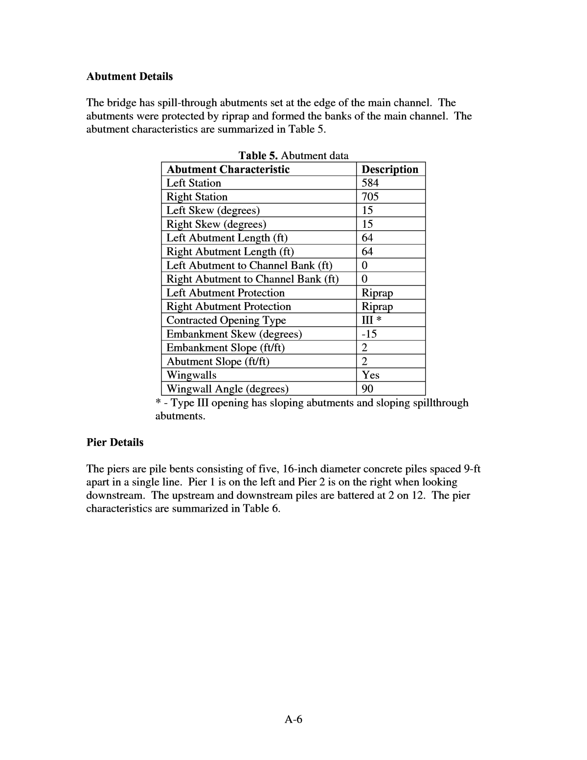
A-6 Abutment Details The bridge has spill-through abutments set at the edge of the main channel. The abutments were protected by riprap and formed the banks of the main channel. The abutment characteristics are summarized in Table 5. Table 5. Abutment data Abutment Characteristic Description Left Station 584 Right Station 705 Left Skew (degrees) 15 Right Skew (degrees) 15 Left Abutment Length (ft) 64 Right Abutment Length (ft) 64 Left Abutment to Channel Bank (ft) 0 Right Abutment to Channel Bank (ft) 0 Left Abutment Protection Riprap Right Abutment Protection Riprap Contracted Opening Type III * Embankment Skew (degrees) -15 Embankment Slope (ft/ft) 2 Abutment Slope (ft/ft) 2 Wingwalls Yes Wingwall Angle (degrees) 90 * - Type III opening has sloping abutments and sloping spillthrough abutments. Pier Details The piers are pile bents consisting of five, 16-inch diameter concrete piles spaced 9-ft apart in a single line. Pier 1 is on the left and Pier 2 is on the right when looking downstream. The upstream and downstream piles are battered at 2 on 12. The pier characteristics are summarized in Table 6.
A-7 Table 6. Pier data. (--, not available) Surveyed Elevations Water-surface elevations were measured from the bridge deck. The elevation of the bridge deck was determined from the bride plans. All measurements were made between the leftmost pier and the left abutment. The datum for all measurements was mean sea level (MSL). A summary of the measured water-surface elevations is presented in the Table 7. Table 7. Water-surface elevations measured from the County Route 22 bridge deck. A local right-hand coordinate system was established with the positive y-axis in the upstream direction and the x-axis parallel to the upstream face of the bridge. This resulted in x-coordinates increasing from right to left. Since step-backwater models typically use left to right coordinates, stationing was added, which increases from left to right. The stationing on the two sections 500-ft upstream was adjusted so that the main channel aligned with the main channel at the bridge. Pier ID Bridge Station (ft) Alignment Highway Station Pier Type # of Piles Pile Spacing (ft) 1 666 15 Group 5 9 2 624 15 Group 5 9 Pier ID Pier Width (ft) Pier Shape Shape Factor Length (ft) Protection Foundation 1 1.33 Round -- -- Unknown Unknown 2 1.33 Round -- -- Unknown Unknown Pier ID Top Elevation (ft) Bottom Elevation (ft) Cap Shape Pile Tip Elevation (ft) 1 -- -- -- Unknown -- 2 -- -- -- Unknown -- Foot or Pile Cap Width (ft) Date Time Upstream (ft) Downstream (ft) 4/4/1997 ---- 1040.13 1039.85 4/5/1997 14:30 1040.57 1040.27 4/9/1997 18:00 1041.20 --- 7/15/1997 14:10 1032.75 ---
A-8 PHOTOS Figure 4. Looking upstream from County Route 22 bridge deck during low flow. Figure 5. Looking downstream from County Route 22 bridge deck during low flow.
A-9 Figure 6. Looking at scoured area on right upstream bank of County Route 22, during low flow. MEASURED SCOUR All bathymetry data were collected by floating an echo sounder attached to a knee-board across the river while being controlled by a hand line from the bridge. The board was allowed to float downstream and streambed elevations were collected as far as 100 ft downstream from the bridge. Data collected upstream of the bridge was restricted to the upstream edge of the bridge deck and the area around the upstream end of the right wing wall. Data could not be collected in the floodplains because of heavy vegetation. Additional bathymetry data were collected 70-ft upstream and 100-ft downstream from the bridge after the flood during a low-water site visit on July 15, 1997. The development of the scour hole adjacent to the right abutment at the upstream bridge face from April 5, 1997 to April 9, 1997 is depicted in Figure 7. Abutment Scour The rightmost pier may have had some effect on the depth of scour at the right abutment, yet it is difficult to determine the effect of the pier on the depth of local abutment scour. The effect of the abutment is believed to be the dominant scouring factor; therefore, all scour is credited to the abutment with none reported for the pier. The observed velocity in the area of the right abutment dropped considerably as the scour-hole depth increased. The velocity at the left abutment held steady through the data-collection period, as did the depth and shape of the scour hole. All abutment-scour measurements were collected from the upstream edge of the bridge.
A-10 Figure 7. Cross-section data collected from the County Route 22 upstream bridge face during the April 1997 flood. The reference surface used to determine the depth of abutment scour was the concurrent ambient bed. The concurrent ambient bed or reference surface is defined as the projected bed level around the abutment scour hole at the time of measurement; therefore, the depth of abutment scour reported is the additional local scour below the depth of contraction scour. Based on the cross sections from the bridge plans there appeared to be little contraction scour. Elevation of reference surfaces used: 4-4-97 â 1030 ft 4-5-97 â 1029 ft 4-9-97 â 1029 ft The velocity reported for âat the abutmentâ is the maximum velocity observed in the area of the scour hole. Note that the velocity dropped considerably at the right abutment as the scour hole depth increased causing an increase in the flow area. The velocity at the left abutment held steady as did the depth and shape of the scour hole. The site characteristics pertinent to abutment scour are summarized in Table 8. 1015 1020 1025 1030 1035 1040 0 10 20 30 40 50 60 70 80 90 100 110 120 DISTANCE FROM LEFT BANK, IN FEET EL EV A TI O N , I N F EE T 4/5/1997 4/9/1997 Left Abutment Right Abutment Pier 1 Pier 2
A-11 Table 8. Abutment scour data (--, not available; ft/s, feet per second; cfs, cubic feet per second; Abut, abutment; Avg, average; US, upstream; DS, downstream) Contraction Scour No hydraulic measurements were made on 4/4/97; however, from the channel-geometry measurements no contraction scour was observed. From the data collected on 4/5/97 and 4/9/97, contraction scour was computed as the difference in average bed elevation between uncontracted and contracted sections, adjusted for bed slope. Based on the elevation of the main channel between the abutment-scour holes there appears to be only 1 ft or less of contraction scour; therefore, a value of zero contraction scour is reported. No measurements in the uncontracted sections could be made; however, comparisons of the center of the contracted section with the cross section on the bridge plans collected in 1991 showed no change in elevation except in the areas affected by local scour. Thus, a zero contraction scour was reported. The average depth and velocity of the contracted section were computed from the discharge measurements. The average depth included the abutment-scour holes. The site characteristics pertinent to contraction scour are summarized in Table 9. Measurment Number Abutment Date Time US/DS Scour Depth (ft) Accuraccy (ft) 1 Right 4/4/1997 Upstream 3.9 1 2 Right 4/5/1997 Upstream 4.1 1 3 Right 4/9/1997 Upstream 10.0 1.5 4 Left 4/4/1997 Upstream 3.0 1 5 Left 4/5/1997 Upstream 2.8 1 6 Left 4/9/1997 Upstream 2.0 1 Measurment Number Sediment Transport Velocity at Abut (ft/s) Depth at Abut (ft) Discharge Blocked (cfs) Avg Velocity Blocked (ft/s) Avg Depth Blocked (ft) 1 Live-bed -- 13.9 -- -- -- 2 Live-bed 8.3 15.6 -- -- -- 3 Live-bed 3.3 21.1 -- -- -- 4 Live-bed -- 13 -- -- -- 5 Live-bed 5.0 14.3 -- -- -- 6 Live-bed 5.1 14 -- -- -- Measurment Number Embankment Length (ft) Bed Material Cohesion D50 (mm) Sigma Debris Effect 1 516 None 0.15 -- Unknown 2 532 None 0.15 -- Unknown 3 546 None 0.15 -- Unknown 4 143 None 0.15 -- Unknown 5 154 None 0.15 -- Unknown 6 165 None 0.15 -- Unknown
A-12 Table 9. Contraction scour data (--, not available; ft/s, feet per second; cfs, cubic feet per second; US, upstream; DS, downstream; Avg, average) COMPUTED SCOUR A calibrated HEC-RAS model of the site was developed to assess how accurately the scour for this flood could have been predicted. The original geometry of the bridge section was taken from the bridge plans and input into the calibrated HEC-RAS model. The approach and exit cross-sections were modified to be consistent with the streambed elevations from the bridge plans. The discharges from both April 5, 1997 and April 9, 1997 were then modeled with the original bathymetry to determine the hydraulic parameters needed for scour components. The analysis did not include data collected on April 4, 1997, because no hydraulic measurements were made on that date. Abutment Scour Abutment scour was computed in HEC-RAS by both the Froehlich equation and the HIRE equation. The data contained in Table 10 show that the Froehlich equation did a good job predicting abutment scour, when compared to the fully developed scour holes on April 9, 1997. The Froehlich equation correctly over-predicted the depth of scour when compared to the scour holes measured on April 5, 1997, which had not fully developed, because the equations predict maximum depth of scour. The HIRE equation overpredicted scour for all situations. Measurment Number Contracted Date Contracted Time Uncontracted Date Uncontracted Time US/DS Scour Depth (ft) 1 4/4/1997 -- -- -- -- 0 2 4/5/1997 -- -- -- -- 0 3 4/9/1997 -- -- -- -- 0 Measurment Number Accuracy (ft) Contracted Avg Vel (ft/s) Contracted Discharge (cfs) Contracted Depth (ft) Contracted Width (ft) 1 1 -- -- -- -- 2 1 4.23 4570 10.1 107 3 1 3.79 5150 12.5 109 Measurment Number Uncontracted Avg Vel (ft/s) Uncontracted Discharge (cfs) Uncontracted Depth (ft) Uncontracted Width (ft) Channel Contraction Ratio 1 --- --- --- --- --- 2 --- --- --- --- --- 3 --- --- --- --- --- Measurment Number Pier Contraction Ratio Scour Location Eccentricity Sediment Transport Bed Form Debris Effect 1 --- Main Channel --- Live-Bed Unknown Unknown 2 --- Main Channel --- Live-Bed Unknown Unknown 3 --- Main Channel --- Live-Bed Unknown Unknown Measurment Number D95 (mm) D84 (mm) D50 (mm) D16(m) Sigma Bed Material Cohesion 1 0.46 0.35 0.15 0.03 --- Non-cohesive 2 0.46 0.35 0.15 0.03 --- Non-cohesive 3 0.46 0.35 0.15 0.03 --- Non-cohesive
A-13 Table 10. Comparison of observed to computed abutment scour at County Route 22 over the Pomme de Terre River in Minnesota. (ft, feet) Local Scour Depth Date Abutment Location Equipment Observed (ft) Froehlich Equation (ft) HIRE Equation (ft) 4/5/97 Right Upstream Echo sounder 3.9 9.5 12.5 4/5/97 Left Upstream Echo sounder 2.6 2.3 9.2 4/9/97 Right Upstream Echo sounder 9.8 10.8 13.5 4/9/97 Left Upstream Echo sounder 2.0 3.0 10.2 Contraction Scour The contraction scour was computed in HEC-RAS by allowing the model to use the default equation (live-bed or clear-water) depending upon the hydraulic conditions computed by the model. The model correctly predicted little or no contraction scour for the prescribed discharges. REFERENCES The data and subsequent analysis of the CR 22 site has been summarized in the following publications: Mueller, D.S., and Hitchcock, H.A., 1998, Scour measurements at contracted highway crossings in Minnesota, 1997: Memphis, Tenn., ASCE, Water Resources Engineering â98, p. 210-215. Mueller, D.S. and Wagner, C.R., âField observations and evaluations of streambed scour at bridges.â Research Report FHWA-RD-01-041, Federal Highway Administration, Washington, DC (November 2002) 117pp. Wagner, C.R. and Mueller, D.S., 2002, Analysis of contraction and abutment scour at two sites in Minnesota, in International Conference on the Scour of Foundations, 1st, College Station, Tex., 2002, Proceedings: College Station, Tex., International Conference on the Scour of Foundations.
A-14 Any questions regarding the CR 22 bridge over the Pomme De Terre River should be directed to the following points of contact: 1. David Mueller, U.S. Geological Survey 9818 Bluegrass Parkway Louisville, KY 40299 Phone: (502) 493-1935 e-mail: dmueller@usgs.gov 2. Chad Wagner, U.S. Geological Survey 3916 Sunset Ridge Road Raleigh, NC 27607 (919) 571-4021 e-mail: cwagner@usgs.gov SUPPORTING DATA The following is a listing of supporting files that are associated with the CR 22 bridge: PDT22-brgpln-profile.jpg - profile plot from bridge plan, includes bed material information. Planview.wmf - is a file showing the bridge with a sketch of the channel and the locations of the cross sections. Note the location of the cross sections from the bridge plans located 500 ft upstream and downstream are approximate. PDT22-pier-details.jpg - scan of bridge plan pier details PDT22-topo.jpg PDT22-brgpln-profile.jpg Photos taken on 7-15-97: PDT22-ds-bridge.jpg - photo along downstream edge of bridge PDT22-ds-channel.jpg - photo of main channel downstream PDT22-ds-lbnk.jpg - photo of left bank downstream from bridge PDT22-ds-rbnk.jpg - photo of right bank downstream from bridge PDT22-us-bridge.jpg - photo along upstream edge of bridge Photos taken on 10/29/01 HWY220001.jpeg â Looking downstream at right bend from left upstream fldpln HWY220002.jpeg â same as 0001 HWY220003.jpeg â Left upstream fldpln near bend closest to bridge HWY220004.jpeg â Looking upstream at left fldpln, upstream of bridge, OP#2 HWY220005.jpeg â same as 0004 HWY220006.jpeg â same as 0004 HWY220007.jpeg â Looking at upstream right fldpln from roadway, OP#3 HWY220008.jpeg â same as 0007, looking at US x-secs 9 and 10.
A-15 HWY220009.jpeg â Looking downstream at right fldpln, OP#4 HWY220010.jpeg â Looking downstream from roadway, OP#4 HWY220011.jpeg â same as 0010 HWY220012.jpeg â USGS employee collecting bathymetry data with scour board HWY220013.jpeg â Scour board collecting bathymetry data HWY220014.jpeg â same as 0012 HWY220015.jpeg â Looking downstream from bridge deck HWY220016.jpeg â same as 0015 HWY220017.jpeg â same as 0015 HWY220018.jpeg â Looking upstream from bridge deck HWY220019.jpeg â Upstream bridge face and area of scour along right bank HWY220020.jpeg â Looking upstream at channel and left overbank from deck HWY220021.jpeg â Looking at right abutment from US left bank HWY220022.jpeg â Looking at bridge from US left bank, in bend HWY220023.jpeg â Looking upstream at upstream bend from left bank HWY220024.jpeg â same as 0021 HWY220025.jpeg â Looking at DS right bank from left abutment HWY220027.jpeg â same as 0025 HWY220028.jpeg â Looking DS from left abutment HWY220029.jpeg â Looking US at right bank from left abutment HWY220030.jpeg â Looking US from left abutment HWY220031.jpeg â Upstream left floodplain, gravel pits HWY220032.jpeg â same as 0031 HWY220033.jpeg â Downstream left floodplain HWY220034.jpeg â Looking westward at upstream bridge face from roadway HWY220035.jpeg â Upstream left overbank HWY220036.jpeg â Looking eastward at upstream right overbank from roadway HWY220037.jpeg â Looking westward at bridge from roadway HWY220038.jpeg â Upstream bridge face / the source of 3 days of pleasant odors HWY220039.jpeg â Upstream right overbank from bridge deck CR22PDT.doc - MS Word summary of site, bridge and scour data CR22PDT.xls - contains the following worksheets cross sections are label by location upstream (us) or downstream (ds) distance from bridge date or source (bp is bridge plans) See appropriate worksheet us500_bp us70_7-15 us50_7-15 us50_7-15(2) usfv_bp us0_4-4
A-16 us0_4-5 us0_4-9 us0Q_4-5 us0Q_4-9 us0Q_7-15 lsrtww_4-9 - longitudinal section along the right wing wall lsp1p2_7-15 - longitudinal section between piers 1 and 2 ds0_4-4 ds0_4-5 ds0_7-15 dsfv_bp ds10_4-9 ds15_4-5 ds20_4-9 ds25_4-4 ds40_4-5 ds50_4-4 ds50_4-9 ds50_7-15 ds80_4-5 ds80_4-5(2) ds90_4-9 ds100_4-4 ds100_7-15 ds500_bp Q4-5-97- velocities from discharge measurement on 4-5-97 Q4-9-97 - velocities from discharge measurement on 4-9-97 Q7-15-97 - velocities from discharge measurement on 7-15-97 Hydrograph - hydrograph from nearest gage
A-17 CASE STUDY #2 U.S. Route 12 over the Pomme De Terre River near Holloway, Minn. SITE OVERVIEW U.S. Route 12 crosses the Pomme de Terre River about 10.7 miles west of Danvers, Minnesota. The Appleton USGS streamflow-gaging station (05294000) is located approximately 12 miles downstream of the U.S. Route 12 bridge. The single-span steel- truss structure was constructed in 1933 with a maximum span length of 87.3 feet. The bridge has vertical-wall abutments with wing walls; each abutment and wing wall rests on concrete footings supported on timber piling. Neither abutment was riprapped nor was there any other scour protection measures. A field investigation conducted by BRW, Inc. (1995) prior to the flood revealed no evidence of significant scour at the either of the abutments. The floodplains downstream of the bridge are more heavily wooded and classified on the maps as a wetland area. There is a park on the upstream left bank. A summary of the general site information on the site is found in Table 1. During the April 1997 flood, where an estimated 200-year discharge was calculated at the USGS Appleton streamflow-gaging station, the USGS National Bridge Scour Team made real-time bridge scour measurements at the site. A manned boat was deployed to collect detailed scour data with a 1200 kHz acoustic Doppler current profiler (ADCP) on 4/5/1997 and additional limited-detail data was collected on 4/9/1997 from the bridge deck. The USGS measured considerable contraction and abutment scour at the U.S.12 bridge site. A large scour hole developed at the right abutment, scouring below the abutment cutoff wall resulting in failure of the fill material behind the abutment. Slumping of the embankment slope and some deformation of the approach highway were observed. Although scour measurements showed a scour hole 6.5 feet below the footing of the left abutment, no deformation was observed near the left abutment. These conditions resulted in closure of the bridge. Because of the age and scheduled replacement of the bridge, the bridge was not repaired but rather replaced with a new structure following the 1997 flood. The compiled field data (channel and floodplain bathymetry, water discharge, water- surface elevations, roughness, and bridge geometry) were used to calibrate a step- backwater model at each site. Abutment and contraction scour were calculated in HEC- RAS (U.S. Army Corps of Engineers, 1998) using the equations and methods outlined in HEC-18 (Richardson and Davis, 2001) and then compared with the field measurements. Hydrologic Conditions Record snowfall and snowpack-moisture content, combined with excessive soil moisture conditions in much of North Dakota, South Dakota, and Minnesota let to severe flooding during April 1997. During the winter of 1996-97, precipitation amounts in nearly all of the west-central portions of Minnesota were equal to or in the excess of the 90th percentile based on the 30-year period from 1961 to 1990.
A-18 Table 1. Site information Site Characteristic Description County Swift Nearest City Holloway State Minnesota Latitude 45o16â58ââ Longitude 95o58â45ââ Route Number 12 Route Class US Stream Name Pomme De Terre Record or near-record amounts of snowfall occurred in most of the western portions of Minnesota during this period. Snowfall totals were particularly high in the upper Minnesota River valley. Warm temperatures in late March initiated snowmelt, producing record flooding; however, a late-spring storm and falling temperatures added more than 2 inches of precipitation in the form of rain and up to 23.5 inches of snow in some areas. Discharge exceeded the 200-year flood on the Pomme de Terre River near Appleton, Minn. and the 100-year flood on the Minnesota River at Montevideo, Minn. A discharge measurement of 5750 ft3/s was made at the U.S. 12 bridge during the site visit on 4/9/97. DISCUSSION OF CONTRACTED SITE The bridge had a channel contraction ratio of around 0.48, with a most of the contracted flow coming from the left floodplain. A berm located approximately 100 feet upstream of the bridge on the left overbank directed the contracting flow into the channel upstream of the left abutment (see Figure 1). 308.7 306.0 309.0 306.6 306.3 306.6 307.8 303.8 304.7 304.1 303.2 302.6 302.0 303.8 302.9 304.1 306.3 303.8 N 306.0 EMBANKMENT AND ROAD FAILURE MAIN CHANNEL . . . . .. . . . . . . . .. .. . . NOT TO SCALE LEFT ABUTMENT FOOTING ELEVATION 306.3 M RIGHT ABUTMENT FOOTING ELEVATION 306.6 M . SURFACE-CURRENT PATTERN SPOT ELEVATION EXPLANATION Figure 1. Sketch of U.S. Route 12 over Pomme de Terre River, Minnesota showing spot elevations and surface current patterns on April 9, 1997. (Elevations are in meters referenced to NGVD of 1929, 1 meter = 3.2808 feet)
A-19 Bridge Data Structure #5359, at the time of the scour measurements, was an old truss bridge with a perpendicular alignment to the main channel. However, during the 1997 flood there was considerable skew as a significant amount of flow was coming from the left floodplain. The flow through the bridge opening in the center of the channel was skewed about 50 degrees. The U.S. 12 bridge was a single-span 88 ft wide structure with vertical abutments and wingwalls (type IV contracted opening). The low-chord elevation was 1023.85 ft above sea level. Bridge characteristics pertinent to scour are summarized in Table 2. Table 2. Bridge data Bridge Characteristic Description Structure Number 5359 Length (ft) 88.3 Width (ft) 27 Spans 1 Vertical Configuration Sloping Low Chord Elev (ft) 1023.85 Upper Chord Elev (ft) 1024.76 Overtopping Elev (ft) 1027.6 Skew (degrees) 0 Guide Banks None Waterway Classification Main Year Built 1933 Avg. Daily Traffic Unknown Plans on File Yes Parallel Bridges No Continuous Abutments N/A Geomorphic Setting The U.S. 12 bridge is located in a relatively straight section of the Pomme De Terre river. A low-head dam (spillway elevation 1015 ft) is located approximately 300 ft upstream of the bridge. The right floodplain is forested and narrow relative to the left floodplain, which was less densely vegetated. A small park with picnic Tables and restroom facilities is located upstream of the U.S. 12 bridge on the left overbank. During the two site visits in April 1997, the floodplain flow was highly skewed through the bridge opening from the relatively wide left floodplain but the observed roadway and embankment failure was along the right abutment. A plan view of the U.S. 12 bridge site configuration is shown in Figure 2 and a USGS 7.5 minute quadrangle topographic map of the site is shown in Figure 3. Data characterizing the geomorphic setting is summarized in Table 3.
A-20 Figure 2. Plan view of U.S. 12 bridge site over the Pomme De Terre River.
A-21 Figure 3. USGS topographic map of U.S. 12 bridge over the Pomme De Terre River near Holloway, MN. Table 3. Geomorphic data Geomorphic Characteristic Description Drainage Area (square miles) 845 Slope in Vicinity (ft/ft) .0005 Flow Impact Right Channel Evolution Pre-modified Armoring Unknown Debris Frequency Rare Debris Effect None Stream Size Small Flow Habit Perennial Bed Material Sand Valley Setting Low relief Floodplain Width Wide Natural Levees Unknown Apparent Incision None Channel Boundary Alluvial Banks Tree Cover Medium Sinuosity Straight Braiding None Anabranching None Bars Narrow Stream Width Variability Equiwidth Flow U.S. 12 Bridge
A-22 Bed Material Data The bed material size distribution that is reported for the U.S. 12 bridge site are from information provided the Minnesota Department of Transportation (MnDOT). A review of the lithologic logs for the replacement bridge show that the subsurface material is primarily sands, silts, with some gravel with a D50 = .15 mm. Roughness Coefficients A distribution of Manning's n values is provided in Table 4. Table 4. Manningâs n values for the Pomme De Terre River at the U.S. 12 bridge. (fldpln, floodplain; chnl, channel; rt, right) Abutment Details The U.S. 12 bridge had vertical abutments with wingwalls set at the edge of the channel (see Figure 4). The abutment characteristics are summarized in Table 5. Table 5. Abutment data Abutment Characteristic Description Left Station 35917.33 Right Station 35567.83 Left Skew (deg) 0 Right Skew (deg) 0 Left Abutment Length (ft) 67 Right Abutment Length (ft) 67 Left Abutment to Channel Bank (ft) 0 Right Abutment to Channel Bank (ft) 0 Left Abutment Protection None Right Abutment Protection None Contracted Opening Type III* Embankment Skew (deg) -35 Embankment Slope (ft/ft) .09 Abutment Slope (ft/ft) 2 Wingwalls No Wingwall Angle (deg) N/A * - Type III opening has sloping abutments and sloping spillthrough abutments. Flow Type Left Fldpln Main Chnl Rt Fldpln Flow Type Left Fldpln Main Chnl Rt Fldpln High 0.08 0.035 0.08 High 0.1 0.035 0.1 Typical -- 0.030 -- Typical 0.08 0.030 0.08 Low 0.05 -- 0.05 Low -- -- -- Upstream Downstream
A-23 Pier Details There were no piers associated with the U.S. 12 bridge over the Pomme De Terre river. Surveyed Elevations Elevations are referenced to MSL based on values provided by MnDOT on their scour- monitoring plan. Plans for the new bridge developed by BRW showed elevations 30 ft higher. The scour report from BRW agreed with the MnDOT scour-monitoring plan and thus, that elevation reference was used. The top of curb near the east (left) abutment was used as a tape down location and was to have an elevation of 998.7 ft. The horizontal stationing of data collected from the bridge deck was also referenced to the east abutment then adjusted in post-processing to be consistent with stationing used in the BRW, Inc. WSPRO model. Distance of ADCP data from the bridge was visually estimated. Horizontal stationing for the ADCP is based on bottom tracking. The stationing was visually adjusted to agree with the BRW WSPRO model. The elevations that were provided by MnDOT, and the elevations from the BRW sour report, when used to build a HEC-RAS model of the bridge section, were discovered to be inconsistent with the downstream gaging station (Appleton) elevations during the 1997 flood. MnDOT was again contacted and it was discovered that elevation 995 ft above MSL on the BRW scour report should actually be 1023.9 feet above MSL, thus validating the new bridge plan elevations. Therefore, the elevation of the top of curb near the east abutment should actually be 1027.6 ft, making the bridge section more consistent with elevations upstream at the C.R. 22 bridge and downstream at the Appleton gaging station. A correction of +28.9 ft should be made to MnDOT's reference elevation on their sour monitoring plan and all elevations from the BRW sour report. The April 1997 field data, found in the supporting excel file (us12pdt-REV.xls), has already been corrected to reflect the new reference elevation. A summary of the measured water surface elevations is presented in the Table 7.
A-24 Figure 4. Pictures of the U.S. 12 bridge abutments taken during low-flow prior to the 1997 flood on the Pomme De Terre River. Table 7. Water-surface elevation measured from the U.S. 12 bridge deck. Date Time Upstream (ft) Downstream (ft) 4/5/1997 -- 1019.4 --- 4/9/1997 -- 1021.9 ---
A-25 PHOTOS Figure 5. Looking at the upstream U.S. 12 bridge face from right bank during the April, 1997 flood. Figure 6. Scour measurement at upstream right wingwall of U.S. 12 bridge over the Pomme De Terre River; notice slump failure of embankment. Slump Failure
A-26 Figure 7. Looking upstream at U.S. 12 bridge over the Pomme De Terre River during low-flow prior to the April, 1997 flood. Figure 8. Looking upstream from U.S. 12 bridge deck at the small dam on the Pomme De Terre River during low-flow prior to the April, 1997 flood. Figure 9. Looking at upstream right abutment and embankment of U.S. 12 bridge during low-flow prior to April, 1997 flood.
A-27 Figure 10. Looking downstream from replaced U.S. 12 bridge deck during low-flow following the April, 1997 flood. Figure 11. Looking upstream from replaced U.S. 12 bridge deck during low-flow following the April, 1997 flood; notice the absence of the small upstream dam. MEASURED SCOUR All bathymetry data used to estimate the contraction and abutment scour were collected on 4/9/97 with both a sounding weight and transducer mounted on a knee-board. The knee-board was floated from upstream to downstream under the bridge to determine depth of flow through the bridge opening. Cross sections in the main channel were collected 300 feet upstream and downstream of the bridge on 4/5/97, but measurements on 4/9/97 were limited to the bridge opening. Data could not be collected in the
A-28 floodplains because of heavy vegetation and submerged structures in the park located on the left overbank, upstream of the bridge. A plot of measured cross-section in the bridge opening is illustrated in Figure 12. Figure 12. Cross-section data collected at the U.S. highway 12 bridge over the Pomme de Terre River on April 5, 1997 and April 9, 1997. Abutment Scour There was significant flow from the left upstream flood plain through the bridge opening. This flow from the left flood plain significantly skewed the flow through the bridge opening, about 50 degrees on the average. The reference surface used to determine the depth of abutment scour was the concurrent ambient bed. Therefore, the depth of abutment scour reported is the additional local scour below the depth of contraction scour. For this site, it appears that the scour holes may interact as there is only one or two depth measurement between the holes that define the ambient bed. Measurements numbers 1 and 4 were made with a sounding weight during a discharge measurement along the upstream face of the bridge. All other measurements were made using an echo sounder mounted on a knee-board. The site characteristics pertinent to abutment scour are summarized in Table 8. Pomme de Terre River at U.S. Highway 12 990 995 1000 1005 1010 1015 1020 1025 1030 940 950 960 970 980 990 1000 1010 1020 1030 1040 1050 STATION, IN FEET EL EV A TI O N , I N F EE T 4-9-97 US Bridge Face 4-9-97 DS Bridge Face 4-5-97 US Bridge Face 4-5-97 DS Bridge Face Left Bank Right Bank
A-29 Table 8. Abutment scour data (--, not available; ft/s, feet per second; cfs, cubic feet per second; Abut, abutment; Avg, average; US, upstream; DS, downstream) Measurement Number Abutment Date Time US/DS Scour Depth (ft) Accuracy (ft) 1 Right 4/9/1997 16:00 Upstream 8.0 2 2 Right 4/9/1997 14:00 Upstream 7.0 2 3 Right 4/9/1997 14:00 Downstream 11.0 2 4 Left 4/9/1997 16:00 Upstream 3.0 2 5 Left 4/9/1997 14:00 Upstream 1.5 2 6 Left 4/9/1997 14:00 Downstream 6.0 2 Measurement Number Sediment Transport Velocity at Abut (ft/s) Depth at Abut (ft) Discharge Blocked (cfs) Avg Velocity Blocked (ft/s) Avg Depth Blocked (ft) 1 Live-bed 4.2 30 -- -- -- 2 Live-bed 4.2 31 -- -- -- 3 Live-bed 4.2 27 -- -- -- 4 Live-bed 3.8 25 -- -- -- 5 Live-bed 3.8 25 -- -- -- 6 Live-bed 3.8 22 -- -- -- Measurement Number Embankment Length (ft) Bed Material Cohesion D50 (mm) Sigma Debris Effect 1 396 None 0.15 -- Insignificant 2 396 None 0.15 -- Insignificant 3 396 None 0.15 -- Insignificant 4 1006 None 0.15 -- Insignificant 5 1006 None 0.15 -- Insignificant 6 1006 None 0.15 -- Insignificant Contraction Scour Contraction scour was computed as the difference in average bed elevation between uncontracted and contracted sections, adjusted for bed slope. The appropriate reference surface was determined from an analysis of cross sections collected by BRW on 6/5/95 and the USGS during the flood on 4/5/97. Cross sections on these two dates collected approximately 300 ft upstream from the bridge show only about a 0.5 ft difference in the channel bottom elevation. The flood section was the lower of the two. Downstream from the bridge the cross section surveyed on 6/5/95 (approximately 75 ft downstream) and the cross section surveyed on 4/5/97 (approximately 200 ft downstream) are similar, with less than 1 ft in variation in the channel bottom elevations. The 4/5/97 cross section 100 ft downstream was about 1.5 below the 6/5/97 cross section
A-30 at 75 ft downstream. It was assumed that the 4/5/97 cross section could have been affected by the scour at the bridge section. Thus, it was not considered in the setting of the reference surface. The WSPRO bridge section surveyed by BRW on 6/5/95 showed from 1 to 2 ft of abutment scour in the cross-section. However, the center of the channel at the bridge appears to be representative of consistent channel slope from the upstream section to the downstream section. Since little general scour was observed at the upstream and downstream sections the mean elevation of the unscoured portion of the WSPRO bridge section was used as the contraction scour reference surface, elevation 1010.4 ft. The contracted section on 4/5/97 was measured under the bridge from data collected by an acoustic Doppler current profiler. The depths represent a weighted average of the four beam depths. Because a weighted-average was used it is possible that the local abutment scour was not detected. The maximum lowering of the streambed was actually 7.5 ft; however, when the entire bed below the bridge was averaged the depth of contraction scour was only 3.1 ft. The hydraulic data presented for measurement number 1 were collected with the ADCP. The ADCP data showed many missing ensembles that were estimated in the final processing. There was not clear delineation of the channel banks in the approach section, creating a degree of uncertainty in the approach discharge. Overall it is expected that the approach discharge is +/- 20% and the total discharge is +/- 10%. Measurements number 2 was made during a discharge measurement along the upstream face of the bridge. The depths were measured with a sounding weight. Measurements 3 and 4 were made using an echo sounded mounted on a knee-board. The board was floated from upstream to downstream under the bridge. The measurements reflect the depths at the upstream or downstream face of the bridge. The cross sections measured on 4/9/97 all showed a similar pattern with abutment scour holes on each side and a sharp mound in between the scour holes but skewed towards the left bank. It appears that the abutment scour holes may have overlapped. The highest elevation in the center of the cross section was subtracted from the reference surface to obtain the depth of contraction scour. No data in the approach section was collected on 4/9/97. The site characteristics pertinent to contraction scour are summarized in Table 9.
A-31 Table 9. â Contraction scour data (--, not available; ft/s, feet per second; cfs, cubic feet per second; US, upstream; DS, downstream; Avg, average) Measurement Number Contracted Date Contracted Time Uncontracted Date Uncontracted Time US/DS Scour Depth (ft) 1 4/5/1997 11:30 4/5/1997 -- US 3.1 2 4/9/1997 16:00 -- -- US 10.5 3 4/9/1997 14:00 -- -- US 12.5 4 4/9/1997 14:00 -- -- DS 4.5 Measurement Number Accuracy (ft) Contracted Avg Vel (ft/s) Contracted Discharge (cfs) Contracted Depth (ft) Contracted Width (ft) 1 2 4.8 5000 12.1 88 2 2 2.7 5750 24 88 3 2 2.8 5750 23.6 88 4 2 3.8 5750 17.3 88 Measurement Number Uncontracted Avg Vel (ft/s) Uncontracted Discharge (cfs) Uncontracted Depth (ft) Uncontracted Width (ft) Channel Contraction Ratio 1 3.4 1800 7.9 70 0.64 2 --- --- --- --- --- 3 --- --- --- --- --- 4 --- --- --- --- --- Measurement Number Pier Contraction Ratio Scour Location Eccentricity Sediment Transport Bed Form Debris Effect 1 --- Main Channel --- Live-Bed Unknown Unknown 2 --- Main Channel --- Live-Bed Unknown Unknown 3 --- Main Channel --- Live-Bed Unknown Unknown 4 --- Main Channel --- Live-Bed Unknown Unknown Measurement Number D95 (mm) D84 (mm) D50 (mm) D16(m) Sigma Bed Material Cohesion 1 0.28 0.23 0.15 <.062 1.5 Non-cohesive 2 0.28 0.23 0.15 <.062 1.5 Non-cohesive 3 0.28 0.23 0.15 <.062 1.5 Non-cohesive 4 0.28 0.23 0.15 <.062 1.5 Non-cohesive
A-32 COMPUTED SCOUR A calibrated HEC-RAS model of the site was developed to assess how accurately the scour for this flood could have been predicted. The pre-flood geometry of the bridge section was simulated with a HEC-RAS model utilizing the channel geometry from the original bridge plans and the low-flow survey conducted by BRW, Inc. on 6/5/1995. A separate model was developed with the main channel geometry data collected during the April, 1997 flood. The discharges measured during the April, 1997 flood were then modeled with the pre-flood and flood bathymetry to determine the hydraulic parameters needed for HEC-18 scour computations. Abutment Scour Abutment scour was computed in HEC-RAS by both the Froehlich equation and the HIRE equation. The hydraulic parameters taken from the HEC-RAS output were also used to calculate abutment scour using the Sturm abutment scour equation. The data contained in Table 10 show that the method of combining one dimensional model hydraulics and the scour equations grossly overpredicted the scour at the left and right abutments. Overall, the one dimensional step-backwater model was unable to accurately simulate the complex hydrodynamics. Table 10. Comparison of observed to model-computed abutment scour at U.S. 12 over Pomme De Terre River near Holloway, MN. Local Scour Depth Date Abutment Location Observed (ft) Froehlich Equation (ft) HIRE Equation (ft) Sturm Equation (ft) 4/9/97 Right Upstream 8 15.1 35.4 6.7 4/9/97 Right Downstream 11 15.1 35.4 6.7 4/9/97 Left Upstream 3 13.1 17.1 6.8 4/9/97 Left Downstream 6 13.1 17.1 6.8 Contraction Scour The contraction scour was computed in HEC-RAS by allowing the model to use the default equation (live-bed or clear-water) depending upon the hydraulic conditions computed by the model. The results of the model are compared with observed contraction scour in Table 11.
A-33 Table 11. Comparison of observed to model-computed contraction scour at U.S. 12 over Pomme De Terre River near Holloway, MN. Contraction Scour Depth Date Observed (ft) LiveBed (ft) 4/5/97 3.1 2.0 REFERENCES Any questions regarding the U.S. 12 over Pomme De Terre River should be directed to the following points of contact: 1. David Mueller, U.S. Geological Survey 9818 Bluegrass Parkway Louisville, KY 40299 Phone: (502) 493-1935 e-mail: dmueller@usgs.gov 2. Chad Wagner, U.S. Geological Survey 3916 Sunset Ridge Road Raleigh, NC Phone: (919) 571-4021 e-mail: cwagner@usgs.gov SUPPORTING DATA The following is a listing of supporting files that are associated with the U.S. 12 bridge: us12pdt-REV.xls - contains the following data: Summary - Summary of basic site and scour data Hydrograph - Hydrograph from nearest USGS gaging station X-Sec â cross-section data Site Photos: -------------------------------------------- The following photos were scanned from a black and white copy of the bridge scour evaluation report completed by BRW: pdt12-scrrpt-ds-channel.jpg pdt12-scrrpt-abuts.jpg pdt12-scrrpt-bridge.jpg pdt12-scrrpt-nwcorner-bridge.jpg pdt12-scrrpt-us-channel.jpg pdt12-scrrpt-us-dam.jpg
A-34 pdt12-brgpln-siteplan.jpg is a site plan scanned from the bridge plans provided by MnDOT. The following photos/sketches were taken during the April, 1997 flood: pdt12-flood-us-bridge.jpg is a photo taken during the flood, from the right bank looking across the face of the bridge to the left floodplain. Note the slump in the foreground. pdt12-flowfield.jpg - sketch of flow field observed on 4-9-97 pdt12-rwingwall - photo of data collection along the right upstream wingwall. Note the slump in the embankment. HEC-RAS Files ------------------------------------------------ PreFlood_US12.zip â HEC-RAS model files with pre-flood bathymetry, includes scour computations. Flood_US12.zip â HEC-RAS model files with main channel bathymetry collected during flooding on April 9, 1997; used as calibration model.
A-35 CASE STUDY #3 Minnesota River at State Route 25 near Belle Plaine, Minnesota SITE OVERVIEW The study site is located on the Minnesota River .7 miles north of the town of Belle Plaine on State Highway 25. The site is approximately 7.5 miles upstream from the USGS gaging station near Jordan (05330000) and 12 miles downstream from the USGS gaging station at Henderson (33032001). The period of record for the Jordan station is from October 1935 to the current year, with an annual mean flow of 4425 cfs, and an instantaneous peak flow of 117,000 cfs recorded on April 11, 1965. The USGS measured a discharge of 73,200 cfs and significant abutment and contraction scour at the site during real-time bridge scour measurements during the flood in April of 2001. Detailed discharge, velocity, and cross-section data were collected throughout a reach extending 1400 feet (ft) upstream and 1700 ft downstream of the bridge using an acoustic Doppler current profiler deployed on a manned boat during the flood on 4/17/2001. The structure number for this site is 5260. The Minnesota Dept of Transportation (MnDOT) built the current bridge in 1934. The channel bottom at the time of construction was at approximately the same elevation as the top of footings (elevation 695 ft). Eventually, the channel was scoured well below the footing bottoms, requiring re- stabilization of the channel bed around the piers and left abutment with rip-rap due to a flood in April of 1951 that caused extensive scouring of the channel. An underwater inspection was completed in 1991 and 2000. The 2000 inspection report contained upstream and downstream bridge face profiles, which reflected streambed elevations had been returned to levels similar to the initial construction conditions. Both inspections revealed the piers to be in generally good structural condition. Debris buildup at the piers appears to be a recurring problem, especially at pier 1. Several measurements of scour have occurred at this site, by MnDOT and Collins Engineers, Inc. Collins Engineers, Inc. performed a series of investigations on the highway 25 bridge in the mid to late 1990's and found the bridge to be in good condition with minor scour depressions at the upstream end of pier #2. The USGS revisited the site in October 2001 to conduct a post-flood survey and noted that both abutments had been re-stabilized and lined with riprap as a result of the damage produced by the April 2001 flood. A summary of the general site information is found in Table 1. A step-backwater hydraulic model (HEC-RAS) of the S.R. 25 site was developed as part of a bridge scour investigation report (consultant agreement no. 70490) for the Minnesota Department of Transportation in January, 1994. A separate HEC-RAS model was developed and calibrated by the USGS using channel geometry and field hydraulic measurements collected during the April, 2001 flood. Both models were used to predict the amount of abutment and contraction scour expected for the various geometric configurations using the techniques and equations from HEC-18.
A-36 Table 1. Site information Site Characteristic Description County Scott Nearest City Belle Plaine State Minnesota Latitude 44o38â02ââ Longitude 93o45â58ââ Route Number 25 Route Class State Stream Name Minnesota River Hydrologic Conditions Above normal rains in early November 2000 followed by snowfalls later in the month resulted in precipitation totals that were well above historical averages for the month, particularly in the central and southwestern portions of Minnesota. With additional snowfall throughout the winter, total accumulation in parts of southern Minnesota was 18 to 24 inches greater than for a normal winter (USGS MN District, Fact Sheet, 2002). Typically, the snow pack would lose much of itsâ water equivalence from later winter to early spring, before the arrival of spring rains. However, below-normal temperatures for February and March delayed the snowmelt and only compacted the existing snow cover. In April, heavy rains fell over much of the central and southern parts of the state which coupled with greater than normal snow-to-water equivalents to provide the excessive runoff that resulted in the April, 2001 flooding. A discharge of 73,200 cubic feet per second (cfs) was measured at the site during the visit, which has approximately a 35-year recurrence interval according to the peak flow frequency analysis developed for the Jordan, MN USGS gaging station. DISCUSSION OF CONTRACTED SITE The Minnesota River has a series of low radius bends that cause a slightly up-valley flow in the main channel upstream of the S.R. 25 bridge, which added complexity to the scour analysis. The upstream bends appear to be actively migrating longitudinally within the valley. A series of oxbow lakes are present on the left floodplain from which a significant part of the floodplain flow is blocked and forced through the bridge opening. A depiction of the hydraulics through the bridge opening during the April 1997 flood is shown in Figure 1. Bridge Data Structure #5260 is a metal truss bridge consisting of 3-150' continuous I-beam spans supported by two concrete column piers with partial web walls, and vertical abutments with wingwalls. Pier #1 is on the right, looking downstream, and is supported by 82 concrete pilings driven to elevations ranging from 660.28' to 637.28'. Pier #2 is
A-37 supported by 82 concrete pilings driven to elevations ranging from 665.96' and 654.96'. The south and north abutments are supported by creosoted piles driven to elevation 670.53' and 665.96', respectively. Both abutments are set back about 30-40 feet from the top of the channel banks and the bridge has a 1% downhill grade in the northbound direction. The bridge characteristics pertinent to scour are summarized in Table 2. Figure 1. Sketch of site hydraulics during April, 2001 flood. Table 2. Bridge data Bridge Characteristic Description Structure Number 5260 Length (ft) 450 Width (ft) 28 Spans 3 Vertical Configuration Sloping Low Chord Elev (ft) 734 Upper Chord Elev (ft) 737 Overtopping Elev (ft) 740 Skew (degrees) 30 Guide Banks None Waterway Classification Main Year Built 1934 Avg. Daily Traffic Unknown Plans on File Yes Parallel Bridges No Continuous Abutments No Geomorphic Setting
A-38 The bridge is located in a sinuous reach of the river in between two small radius bends that flow directly across or even slightly up-valley. These bends are located immediately upstream of the bridge and appear to be actively migrating down-valley. The left floodplain is comprised of young forests and the barren oxbow lakes probably created during construction of the highway. The right floodplain consists of densely populated forests with some areas of un-maintained pastureland. During the site visit in April 2001, the floodplain flow was concentrated in the left floodplain. The concentration of left floodplain flow was attributed to the channel alignment upstream of the bridge. Inspection of the "approach" section (one bridge width upstream) revealed a large discharge relative to that of the contracted opening and a bed elevation similar to the contracted section. It was discovered that the upstream bend forced a majority of the left floodplain flow back into the main channel before the "approach" section, as defined by HEC-18. The reattachment points along the right and left embankments during the flood were located approximately 630 ft and 1775 ft from the bridge, respectively. Data characterizing the geomorphic setting is summarized in Table 3. A topographic map of the site is shown in Figure 2. Table 3. Geomorphic data Geomorphic Characteristic Description Drainage Area (sq mi.) 16010 Slope in Vicinity (ft/ft) .000063 Flow Impact Left Channel Evolution Pre-modified Armoring Unknown Debris Frequency Occasional Debris Effect Local Stream Size Medium Flow Habit Perennial Bed Material Sand Valley Setting Low relief Floodplain Width Narrow Natural Levees Unknown Apparent Incision None Channel Boundary Alluvial Banks Tree Cover Medium Sinuosity Meandering Braiding None Anabranching None Bars Narrow Stream Width Variability Equiwidth
A-39 Figure 2. USGS topographic map of the CR 22 bridge scour site. Bed Material Data Bed material samples at the site were collected on 10/31/2001 with a BM-54H grab sampler from at manned boat at the following four locations in the vicinity of the bridge: 150 ft upstream of bridge in the center of the approach channel, 150 ft downstream of the bridge in the middle of the exit section, in the scour hole at the upstream left abutment in the bridge opening, and in the scour hole on the upstream left bank. The material sampled in the main channel approach section was sand with a D50 = 0.36 millimeters (mm). The grain size distribution of the bed material in the approach section is shown in Figure 3. Roughness Coefficients A complete distribution of Manning's n values is provided in Table 4. Table 4. Manningâs n values upstream and downstream of the CR 22 bridge. (fldpln, floodplain; chnl, channel; rt, right) Flow SR 25 Flow Type Left Fldpln Main Chnl Rt Fldpln Flow Type Left Fldpln Main Chnl Rt Fldpln High 0.085 0.045 0.065 High 0.085 0.05 0.08 Typical 0.05 0.032 0.052 Typical 0.052 0.044 0.052 Low 0.052 0.032 0.052 Low 0.052 0.044 0.052 Upstream Downstream
A-40 Figure 3. Grain size distribution for CR 22 bed material samples Abutment Details The bridge has vertical abutments set back 30-40 ft from the edge of the main channel. Although the abutments were protected by riprap prior to the April, 2001 flood, a site reconnaissance in October, 2002 revealed that both abutments had been re-graded with intermediate breaks in the slope and new rip-rap had been placed (see Figure 4). The abutment characteristics are summarized in Table 5. Table 5. Abutment data Abutment Characteristic Description Left Station 4044.67 Right Station 3593 Left Skew (deg) 0 Right Skew (deg) 0 Left Abutment Length (ft) 77.4 Right Abutment Length (ft) 77.4 Left Abutment to Channel Bank (ft) 37 Right Abutment to Channel Bank (ft) 33 Left Abutment Protection Riprap Right Abutment Protection Riprap Contracted Opening Type IV * Embankment Skew (deg) -30 Embankment Slope (ft/ft) .17 Abutment Slope (ft/ft) 0 Wingwalls Yes Wingwall Angle (deg) 45 * - Type IV opening has sloping abutments and vertical abutments with wingwalls. 0 10 20 30 40 50 60 70 80 90 100 0.010.1110 Diameter (mm) Pe rc en t F in er b y W ei gh t ( % )
A-41 Figure 4. Picture of the re-stabilization done to the left abutment of the S.R 25 bridge over the Minnesota River near Belle Plaine, MN following April, 2001 flood. Pier Details Pier #1 is on the right, looking downstream, and is supported by 82 concrete pilings driven to depths ranging from 660.28' to 637.28'. Pier #2 is on the left, looking downstream, and is supported by 82 concrete pilings driven to elevations ranging from 665.96' and 654.96'. The foundation for both piers is dumbbell shaped with 15.5' square pads on each end connected by a 5' by 14' rectangle. In 1952, the piers were reinforced with stone rip-rap at a 2:1 slope from the top of the foundation due to a major scouring event that occurred in April, 1951. The remaining exposed channel bottom between the piers was lined with stone rip-rap paving to an elevation of 680'. Debris frequently accumulates in front of pier 1 and is a noted problem. The pier characteristics are summarized in Table 6.
A-42 Table 6. Pier data (--, not available) Surveyed Elevations Water-surface elevations were measured from the bridge deck at the upstream left abutment. The vertical control for all surveyed elevations at the site was established from a benchmark (#7003 1973, elevation 741.75ft) located on the downstream right abutment and referenced to feet above mean sea level (MSL). The elevations used to dimension the bridge deck were determined from the bride plans. A summary of the measured water surface elevations is presented in the Table 7. Table 7. Water-surface elevation measured from the S.R. 25 bridge deck. A local right-hand coordinate system was established with the positive y-axis in the upstream direction and the x-axis parallel to the upstream face of the bridge. This resulted in x-coordinates increasing from right to left. Since step backwater models typically use left to right coordinates, stationing was added which increases from left to right. Pier ID Bridge Station (ft) Alignment Highway Station Pier Type # of Piles Pile Spacing (ft) 1 - 0 37+42.75 Single - - 2 - 0 38+94.92 Single - - Pier ID Pier Width (ft) Pier Shape Shape Factor Length (ft) Protection Foundation 1 6.5 Sharp -- 36.75 Riprap Piles 2 6.5 Sharp -- 36.75 Riprap Piles Pier ID Top Elevation (ft) Bottom Elevation (ft) Cap Shape Pile Tip Elevation (ft) 1 696.28 690.28 -- Other 637.3 2 694.76 688.76 -- Other 654.96 Foot or Pile Cap Width (ft) Date Time Upstream (ft) 4/17/2001 ---- 728.5
A-43 PHOTOS Figure 5. Looking at flow contraction from left floodplain and location of upstream left overbank scour hole from right upstream abutment of S.R. 25 bridge during April, 2001 flood. Figure 6. Looking at left upstream overbank scour hole (inside what appears to have been a much larger scour hole) from right bank along the upstream bridge face of S.R. 25 over the Minnesota River during low-flow.
A-44 Figure 7. Looking at turbulent flow and eddy fence attributed to severe contraction along the upstream left abutment of the S.R. 25 bridge during the April, 2001 flood. Figure 8. Looking upstream at S.R. 25 bridge and left abutment during low-flow.
A-45 MEASURED SCOUR All bathymetry data were collected with a 600 kHz ADCP and horizontally referenced with a differentially corrected global positioning system (DGPS). Cross sections in the main channel (tree line of right bank to tree line of left bank) were collected throughout the bridge reach at an approximate spacing of 225 ft upstream and 350 ft downstream of the bridge. The extents of the data collection upstream of the bridge was restricted due to downed power lines spanning the river. Data could not be collected in the floodplains because of heavy vegetation, but an approximation of the flow blocked by the road embankments was developed by cutting off the discharge entering the main channel from either floodplain with the ADCP. A survey of the floodplains and additional bathymetry data was collected in the approach, exit and bridge sections after the flood during a low- water site visit on October 31, 2001. A historic depiction of the scour through the S.R. 25 bridge opening is depicted in Figure 9 and a map of the bathymetric data collected during the April, 2001 flood is illustrated in Figure 10. Figure 9. Historic cross-section data collected at the S.R. 25 bridge over the Minnesota River near Belle Plaine, MN. 660 665 670 675 680 685 690 695 700 705 710 715 720 725 730 735 740 745 0 50 100 150 200 250 300 350 400 450 500 Station (ft) El ev at io n (ft ) 1933 US 1952 US 2000 US 2000 DS 4/17/01 US 4/17/01 DS BridgeDeck LowChord Pier 1Pier 2 Left Abutment Right Abutment
A-46 Figure 10. Bathymetric contour plot of Minnesota River in the vicinity of State Route 25 bridge, collected during April, 2001 flood. Abutment Scour The left upstream abutment was exposed to very high velocities coming out of the left floodplain. Intense boils and eddies were also present through the bridge opening at the left abutment. The left abutment slope and adjacent pier (#2) both had scour protection in the form of riprap. The maximum scour depth in the vicinity of the left abutment during the April, 2001 was actually measured downstream of the bridge (see Figure 9). Although it is difficult to determine the total effect that the riprap had on the depth of local abutment scour, it may have amplified the amount of scour in the channel downstream of the bridge. The riprap prevented scour and equilibrium sediment transport conditions to occur in the bridge opening and thereby shifting the scour process downstream to an unprotected portion of the channel. The reference surface used to determine the depth of abutment scour was the concurrent ambient bed adjacent to the scour holes, which was established from bathymetry data collected upstream and downstream of the bridge during the flood (see Figures 9 and 10).
A-47 The velocity reported for âat the abutmentâ is the maximum velocity observed in the area of the scour hole. The site characteristics pertinent to abutment scour are summarized in Table 8. Table 8. Abutment scour data (--, not available; ft/s, feet per second; cfs, cubic feet per second; Abut, abutment; Avg, average; US, upstream; DS, downstream) Contraction Scour From the data collected on 4/17/01 contraction scour was computed as the difference in average bed elevation between uncontracted and contracted sections (adjusted for bed slope). Inspection of the "approach" section (one bridge width upstream) revealed a large discharge relative to that of the contracted opening and a bed elevation similar to the contracted section. It was discovered that the upstream bend forced a majority of the left floodplain flow back into the main channel before the "approach" section. A cross section made further upstream showed much less discharge, which was consistent with channel discharge downstream of the bridge opening, and an average channel elevation approximately 15 higher than the contracted section. The widths and corresponding hydraulic characteristics for the uncontracted section is representative of the cross-section located just downstream of the upstream bend, rather than the conventional approach section (one bridge width upstream). If the ambient bed was taken at the cross-section one bridge width upstream, the resulting contraction scour would have been only 6ft. Based on the measured elevation of the main channel between the abutment scour holes relative to the upstream ambient bed, there was approximately 15 ft of contraction scour. Comparisons of the center of the contracted section during the April, 2001 flood with the most recent bridge cross section collected on November 3, 2000 showed significant Measurment Number Sediment Transport Velocity at Abut (ft/s) Depth at Abut (ft) Discharge Blocked (cfs) Avg Velocity Blocked (ft/s) Avg Depth Blocked (ft) 1 Live-bed 13.5 56 20800 2 16 2 Live-bed -- 52 20800 2 16 3 Live-bed 5.5 51.5 4200 0.67 10 4 Live-bed -- 50 4200 0.67 10 Measurment Number Embankment Length (ft) Bed Material Cohesion D50 (mm) Sigma Debris Effect 1 1775 None 0.36 -- Insignificant 2 1775 None 0.36 -- Insignificant 3 630 None 0.36 -- Insignificant 4 630 None 0.36 -- Insignificant Measurment Number Abutment Date Time US/DS Scour Depth (ft) Accuraccy (ft) 1 Left 4/17/2001 11:10 Upstream 18.0 2 2 Left 4/17/2001 11:00 Downstream 13.0 3 3 Right 4/17/2001 11:00 Upstream 17.0 2 4 Right 4/17/2001 11:00 Downstream 14.0 3 4 3 2
A-48 change in elevation throughout the bridge opening that is consistent with the reported contraction scour depth (see Figure 9). The average depth and velocity of the contracted section were computed from ADCP data collected throughout the bridge opening. The average depth included the abutment scour holes. The site characteristics pertinent to contraction scour are summarized in Table 9. Table 9. Contraction scour data (--, not available; ft/s, feet per second; cfs, cubic feet per second; US, upstream; DS, downstream; Avg, average) COMPUTED SCOUR A calibrated HEC-RAS model of the site was developed to assess how accurately the scour for this flood could have been predicted. The pre-flood geometry of the bridge section was simulated with a HEC-RAS model developed in 1994 as part of a floodplain delineation project for Scott County, MN. A separate model was developed by the USGS with the geometry data collected during the April, 2001 flood and the subsequent low- flow floodplain survey. The discharge measured on 4/17/2001 (73,200 cfs) was then modeled with the pre-flood and flood bathymetry to determine the hydraulic parameters needed for HEC-18 scour computations. Abutment Scour Abutment scour was computed in HEC-RAS by both the Froehlich equation and the HIRE equation. The hydraulic parameters taken from the HEC-RAS output were also used to calculate abutment scour using the Sturm abutment scour equations. The data contained in Table 10 show although most equations grossly overpredicted the scour at the left and right abutments, the HIRE with hydraulic input from the one-dimensional Measurment Number Contracted Date Contracted Time Uncontracted Date Uncontracted Time US/DS Scour Depth (ft) 1 4/17/2001 11:00 4/17/2001 11:55 -- 15 Measurment Number Accuracy (ft) Contracted Avg Vel (ft/s) Contracted Discharge (cfs) Contracted Depth (ft) Contracted Width (ft) 1 2 4 69800 49 390 Measurment Number Uncontracted Avg Vel (ft/s) Uncontracted Discharge (cfs) Uncontracted Depth (ft) Uncontracted Width (ft) Channel Contraction Ratio 1 3.9 48200 43 300 0.7 Measurment Number Pier Contraction Ratio Scour Location Eccentricity Sediment Transport Bed Form Debris Effect 1 --- Main Channel 0.2 Live-Bed Unknown Unknown Measurment Number D95 (mm) D84 (mm) D50 (mm) D16(m) Sigma Bed Material Cohesion 1 0.5 0.46 0.36 0.25 --- Non-cohesive 32002.9 34 60 0.54
A-49 model incorrectly predicted more scour at the right abutments. The HIRE equation, which includes the velocity at the tip of the abutment, most likely predicted the more scour at the right abutment due to the inability of the HEC-RAS model to accurately simulate the extreme velocity magnitudes that were measured in the field at the left abutment. Overall, the one dimensional step-backwater model was unable to accurately simulate the complex hydrodynamics near the abutments attributed to the high level of flow contraction through the bridge opening. Table 10. Comparison of observed to model-computed abutment scour at S.R. 25 over the Minnesota River near Belle Plaine, MN. Local Scour Depth Date Abutment Location Observed (ft) Froehlich Equation (ft) HIRE Equation (ft) Sturm Equation (ft) 4/17/01 Left Upstream 18 40.3 31.0 40.5 4/17/01 Right Upstream 4 30.7 38.3 17.4 Contraction Scour The contraction scour was computed in HEC-RAS by allowing the model to use the default equation (live-bed or clear-water) depending upon the hydraulic conditions computed by the model. The results of the model are compared with observed contraction scour in Table 11. Table 11. - Comparison of observed to model-computed contraction scour at S.R. 25 over the Minnesota River near Belle Plaine, MN. Contraction Scour Depth Date Observed (ft) LiveBed (ft) 4/17/01 15 35.4 REFERENCES Any questions regarding the S.R. 25 bridge over the Minnesota River should be directed to the following points of contact: 1. David Mueller, U.S. Geological Survey Louisville, KY Phone: (502) 493-1935 e-mail: dmueller@usgs.gov
A-50 2. Chad Wagner, U.S. Geological Survey Raleigh, NC Phone: (919) 571-4021 e-mail: cwagner@usgs.gov SUPPORTING DATA The following is a listing of supporting files that are associated with the S.R. 25 bridge: MN25.jpg â contour plot of detailed bathymetry data collected during April, 2001 flood. MN25.lpk - contour plot of detailed bathymetry data collected during April, 2001 flood, displayed in AmTec's Tecplot software package. Site Photos: -------------------------------------------- DSCN0068.jpg - DSCN0107.jpg - Photos taken during April, 2001 flood and description of each photo are documented in MN25_Photos.doc Word file. HWY250041.jpg - HWY250068.jpg - Photos taken during October, 2001 low-flow survey, description for each is documented in MN25_Post-Flood_Photos.doc Microsoft Word file. Minn25.jpg - USGS topo quad of the bridge site. BellePlaine(Aerial).jpg - Aerial photo of MN 25 bridge site BellePlaine(Aerial)2.jpg - Aerial photo of MN 25 bridge site BellePlaine(Aerial)3.jpg - Aerial photo of MN 25 bridge site BellePlaine(Aerial)4.jpg - Aerial photo of MN 25 bridge site _________________________________ Surveyed Sections: -------------------------------- DS_xsection(HEC-RAS).xls - Excel spreadsheet containing surveyed data for the exit section used in a HEC-RAS model of the reach. US_xsection(HEC-RAS).xls - Excel spreadsheet containing surveyed data for the approach section used in a HEC-RAS model of the reach. 100'_US.xls - Excel spreadsheet containing surveyed data for the section 100' upstream of bridge; location of overbank scour hole. DS_Face.xls - Excel spreadsheet containing surveyed data for the downstream bridge face. US_Face.xls - Excel spreadsheet containing surveyed data for the upstream bridge face. Hwy25_HEC-Ras.xls - Excel spreadsheet summarizing the elev. and stationing for all sections in the HEC-RAS model of the reach. MN25_GrainSizeDist.xls - Bed material grain size distribution for the site, determined by analysis of samples collected during post-flood survey. ADCP_Data.zip - WinZip file containing all ADCP data collected in the reach during April, 2001 flood. The ADCP 3-D velocity data for each transect has been processed into depth-integrated 2-D velocity data and summarized in the .vel files.
A-51 CASE STUDY #4 State Route 37 over the James River near Mitchell, South Dakota SITE OVERVIEW The study site is located on the James River 20 miles north of the town of Mitchell on State Highway 37. The site is approximately 4.5 miles downstream from the USGS gaging station near Forestburg (06477000) and located in a highly rural/agricultural landscape with moderate topographic relief. High flow measurements for the Forestburg gaging station are actually made from the SR 37 bridge therefore a wire weight is installed on the upstream side of the bridge. The period of record for the station is from March 1920 to the current year, with an annual mean flow of 493 cfs, and an instantaneous peak flow of 25,600 cfs recorded on April 6, 1997. The South Dakota USGS measured an approximate peak of 17,100 cfs during the flood of April 2001 during which the USGS National Bridge Scour Team in cooperation with NCHRP and the University of Louisville made real-time bridge scour measurements at the site. A manned boat was deployed during the April 2001 flood and detailed scour data was collected with a 1200 kHz acoustic Doppler current profiler (ADCP). The site was revisited in October, 2001 during low-water to survey the floodplains, collect bed material samples and inspect for remnants of scour associated with the spring flood. The was no road overtopping nor any relief bridges associated with the SR 37 bridge; therefore, all of the flow in the James River contracted and passed through the bridge opening. The bridge is a concrete girder, three span structure supported by two groups of cylindrical piers (3 in each group) which are both founded on steel piles. The upper 10- 15' of the bed is comprised of a sandy-silt followed by 10-20 ft of silty-clay. A summary of the general site information is found in Table 1. A step-backwater hydraulic model (HEC-RAS) of the S.R. 37 site was developed and calibrated by the USGS using channel geometry and field hydraulic measurements collected during the April, 2001 flood. The model was used to predict the amount of abutment and contraction scour expected for various bathymetric configurations in the reach based on one-dimensional hydraulic parameters and equations from HEC-18. Table 1. Site information Site Characteristic Description County Sanborn Nearest City Mitchell State South Dakota Latitude 43o56â33ââ Longitude 98o01â49ââ Route Number 37 Route Class State Stream Name James River
A-52 Hydrologic Conditions Greater than normal precipitation starting with late fall rains in 2000, greater than normal snowfalls, a delayed snowmelt, and above average rains in April, all contributed to the upper Midwestern flooding in the spring of 2001. The James River basin received a surplus of 10 inches of precipitation through the winter of 2000-2001 and the early part of spring 2001. The temperatures in February, March and the first part of April were 10- 15 degrees below normal, which delayed the typical period of snowmelt enough to coincide with a period of above average rainfall associated with a series of cyclonic weather systems characteristic of early spring. A peak discharge of 17,100 cubic feet per second (cfs) was measured at the site during the April 10, 2001 flood, which has approximately a 45-year flood frequency according to the peak flow frequency analysis, developed for the Forestburg (06477000) USGS gaging station. The discharge measured by the USGS during the real-time scour measurements on April 15, 2001 was 15,200 cfs, which is approximately a 35-year discharge. DISCUSSION OF CONTRACTED SITE The bridge had a geometric contraction ratio of around 0.48, with a large majority of the contracted flow coming from the left floodplain. A berm located approximately 100 feet upstream of the bridge on the left overbank directed the contracting flow into the channel upstream of the left abutment (see Figure 1). Figure 1. Looking upstream at left floodplain and berm, from S.R. 37 bridge deck during April, 2001 flood. Bridge Data The structure (#56-150-176) is a 42 ft wide, pre-stressed girder bridge with 3 - 120' spans supported by two piers, both located in the main channel of the James River. Pier #1 is
A-53 on the left, looking downstream, and consists of 3 separate 3.75 ft diameter cylindrical piles. Pier 2 is on the right and also consists of 3 separate 3.75 ft diameter cylindrical piles. The bridge has a type III contracted opening, meaning it has sloping embankments and sloping spillthrough abutments. The bridge has a 2.897% downhill grade in the northbound direction. The low-chord elevation is 1232.6 ft above sea level. The bridge characteristics pertinent to scour are summarized in Table 2. Table 2. Bridge data Bridge Characteristic Description Structure Number 56-150-176 Length (ft) 353 Width (ft) 42 Spans 3 Vertical Configuration Sloping Low Chord Elev (ft) 1232.6 Upper Chord Elev (ft) 1242.8 Overtopping Elev (ft) 1240.6 Skew (degrees) -35 Guide Banks None Waterway Classification Main Year Built 1992 Avg. Daily Traffic Unknown Plans on File Yes Parallel Bridges No Continuous Abutments N/A Geomorphic Setting The geomorphic setting and channel alignment of the James River at the SR 37 bridge is depicted in Figure 2 as well as a graphical representation of the effects of the roadway embankment on the flood-flow. Inspection of the "approach" section (one bridge width upstream) revealed a large discharge relative to that of the contracted opening. It was discovered that the blockage caused by the roadway embankment forced a majority of the left floodplain flow back into the main channel before the "approach" section. A contour plot of the channel bathymetry collected during the April 2001 flood can be found in Figure 3 and a USGS 7.5 minute quadrangle topographic map of the site is shown in Figure 4. Data characterizing the geomorphic setting is summarized in Table 3.
A-54 Figure 2. Geomorphic setting and channel alignment for the James River at SR 37 bridge near Mitchell, SD Table 3. Geomorphic data Geomorphic Characteristic Description Drainage Area 16010 Slope in Vicinity (ft/ft) .000104 Flow Impact Left Channel Evolution Pre-modified Armoring Unknown Debris Frequency Occasional Debris Effect Local Stream Size Medium Flow Habit Perennial Bed Material Silt Valley Setting Low relief Floodplain Width Narrow Natural Levees Unknown Apparent Incision None Channel Boundary Alluvial Banks Tree Cover Medium Sinuosity Meandering Braiding None Anabranching None Bars Narrow Stream Width Variability Equiwidth
A-55 Figure 3. Bathymetric contour plot of James River in the vicinity of S.R. 37 bridge, collected during April, 2001 flood. Figure 4. USGS topographic map of S.R. 37 bridge over the James River near Mitchell, SD Flow
A-56 Bed Material Data Bed material samples were collected at three locations in the main channel on 10/26/2001 with a BM-54H grab sampler; 150 feet upstream of the bridge, in the bridge opening, and 200 feet downstream of the bridge. The samples consisted primarily of a sandy clayey- silt and had a D50 = .02 mm. The grain size distribution of all the samples were very similar with the only difference found in the D95 of the samples in the bridge opening, which was larger (1.4 mm) than the D95 of the samples collected upstream and downstream of the bridge (.27 and .26 mm, respectively). The grain size distributions for the three sample locations are shown in Figures 5-7. Figure 5. Grain size distribution for the bed material sample collected in the SR 37 bridge opening Bridge Opening (SR 37) 0 10 20 30 40 50 60 70 80 90 100 0.0010.010.1110 Diameter (mm) Pe rc en t F in er b y W ei gh t ( % )
A-57 Figure 6. Grain size distribution for the bed material sample collected downstream of the SR 37 bridge. Figure 7. Grain size distribution for the bed material sample collected upstream of the SR 37 bridge. Downstream (SR 37) 0 10 20 30 40 50 60 70 80 90 100 0.0010.010.1110 Diameter (mm) Pe rc en t F in er b y W ei gh t ( % ) Upstream (SR 37) 0 10 20 30 40 50 60 70 80 90 100 0.0010.010.1110 Diameter (mm) Pe rc en t F in er b y W ei gh t ( % )
A-58 Roughness Coefficients A distribution of Manning's n values is provided in Table 4. Table 4. Manningâs n values for the James River at the S.R. 37 bridge. (fldpln, floodplain; chnl, channel; rt, right) Abutment Details The bridge has sloping spill-through abutments with no scour protection. During the site reconnaissance in October, 2001 scour was observed on the left abutment (see Figure 8). The abutment characteristics are summarized in Table 5. Table 5. Abutment data Abutment Characteristic Description Left Station 35917.33 Right Station 35567.83 Left Skew (deg) 0 Right Skew (deg) 0 Left Abutment Length (ft) 67 Right Abutment Length (ft) 67 Left Abutment to Channel Bank (ft) 0 Right Abutment to Channel Bank (ft) 0 Left Abutment Protection None Right Abutment Protection None Contracted Opening Type III* Embankment Skew (deg) -35 Embankment Slope (ft/ft) .09 Abutment Slope (ft/ft) 2 Wingwalls No Wingwall Angle (deg) N/A * - Type III opening has sloping abutments and sloping spillthrough abutments. Left Fldpln Main Cnhl Rt Fldpln 0.08 0.034 0.065
A-59 Figure 8. Picture of the bank failure at the left abutment of the S.R 37 bridge over the James River near Mitchell, SD taken during low-flow survey following April, 2001 flood. Pier Details Pier #1 is on the left, looking downstream, and consists of three 3.75 ft diameter cylindrical piles. Pier #2 is on the right, looking downstream, and also consists of three 3.75 ft diameter cylindrical piles. The elevation at the foundation bottom of Pier #1 and Pier #2 is 1190.84 ft and 1190.83 ft, respectively. The foundation of each pier is supported by 13 steel H-piles pilings. The pier characteristics are summarized in Table 6. Table 6. Pier data (--, not available) Surveyed Elevations Water-surface elevations were measured from the bridge deck using a USGS wire-weight gage located on the upstream bridge face. The vertical control for all surveyed elevations at the site was established from the wire-weight gage check-bar (elevation 37.849 ft, 1246.189 ft above sea level). The elevations used to dimension the bridge deck were Pier ID Bridge Station (ft) Alignment Highway Station Pier Type # of Piles Pile Spacing (ft) 1 - 35 35+80.3 Group 3 19.5 2 - 35 35+68.2 Group 3 19.5 Pier ID Pier Width (ft) Pier Shape Shape Factor Length (ft) Protection Foundation 1 3.75 Round -- 51 None Piles 2 3.75 Round -- 51 None Piles Pier ID Top Elevation (ft) Bottom Elevation (ft) Cap Shape Pile Tip Elevation (ft) 1 1194.84 1190.84 10.5 Square -- 2 1194.83 1194.83 10.5 Square -- Foot or Pile Cap Width (ft)
A-60 determined from the bride plans. A summary of the measured water surface elevations is presented in the Table 7. Table 7. Water-surface elevation measured from the S.R. 37 bridge deck. The low-water survey of the floodplains in the approach and exit sections utilized a local right-hand coordinate system, which was established with the positive y-axis in the upstream direction and the x-axis parallel to the upstream face of the bridge. This resulted in x-coordinates increasing from right to left. Since step backwater models typically use left to right coordinates, stationing was added which increases from left to right. PHOTOS Figure 9. Looking upstream towards left floodplain from bridge deck Figure 10. Looking at upstream bridge face from berm on left bank Date Time Upstream (ft) Downstream (ft) 4/10/2001 ---- 1227.04 -- 4/15/2001 12:30 1224.20 --
A-61 Figure 11. Looking at downstream left floodplain from bridge deck Figure 12. Post-flood conditions, looking upstream at S.R. 37 bridge from right bank Figure 13. Post-flood conditions, looking upstream from S.R. 37 bridge deck
A-62 Figure 14. Post-flood conditions, looking at upstream left floodplain from S.R. 37 bridge. Figure 15. Post-flood conditions, looking at downstream bendway from S.R. 37 bridge. Figure 16. Post-flood conditions, looking at downstream left floodplain from S.R. 37 bridge.
A-63 MEASURED SCOUR All bathymetry data were collected with a 1200 kHz ADCP and horizontally referenced with a differentially corrected global positioning system (DGPS). Cross sections in the main channel (tree line of right bank to tree line of left bank) were collected throughout the bridge reach, which extended 1500 ft upstream and 1200 ft downstream of the S.R. 37 bridge. Data could not be collected in the upstream floodplain because of heavy vegetation, but an approximation of the flow blocked by the road embankments was developed by cutting off the discharge entering the main channel from left floodplain with the ADCP. A survey of the upstream and downstream floodplains was conducted after the flood during a low-water site visit October 28-29, 2001. Abutment Scour The flow separation point on the left valley wall was too far upstream to get a measurement and much of the floodplain flow re-entered the channel by the time it reached the section located one bridge-width upstream. As previously discussed, a section was made with the ADCP along the left bank of the channel to cut-off the floodplain flow entering the channel and gain insight to the amount of discharge that was being blocked by the roadway embankment. The measured live-bed abutment scour at the upstream left abutment was estimated to be 4 feet with accuracy of +/- 2 feet. No scour was detected at the right abutment. The velocity reported for âat the abutmentâ is the maximum velocity observed in the area of the scour hole. The site characteristics pertinent to abutment scour are summarized in Table 8. Table 8. Abutment scour data (--, not available; ft/s, feet per second; cfs, cubic feet per second; Abut, abutment; Avg, average; US, upstream; DS, downstream) Measurement Number Abutment Date Time US/DS Scour Depth (ft) Accuraccy (ft) 1 Left 4/15/2001 13:00 Upstream 4.0 2 Measurement Number Sediment Transport Velocity at Abut (ft/s) Depth at Abut (ft) Discharge Blocked (cfs) Avg Velocity Blocked (ft/s) Avg Depth Blocked (ft) 1 Live-bed 3.8 20 8200 2 6 Measurement Number Embankment Length (ft) Bed Material Cohesion D50 (mm) Sigma Debris Effect 1 1500 Mildly 0.02 -- Insignificant
A-64 Contraction Scour Inspection of the "approach" section (one bridge width upstream) revealed a large discharge relative to that of the contracted opening. It was discovered that the blockage caused by the roadway embankment forced a majority of the left floodplain flow back into the main channel at the "approach" section (see Figure 2). A cross section made further upstream showed much less discharge, which was consistent with channel discharge downstream of the bridge opening. Data from an ADCP section that cut-off the left floodplain flow accounted for all but 500 cfs of the difference in discharge between the "approach" section and the section further upstream. The section furthest upstream was used as the uncontracted section because it was most representative of the flow naturally carried by the main channel had the roadway embankment not be present. The following widths and corresponding hydraulic characteristics for both the contracted and uncontracted sections are representative of the portion of the channel in which live- bed transport would be expected. The measured live-bed contraction scour was estimated to be 3 feet with accuracy of +/- 1 foot. The site characteristics pertinent to contraction scour are summarized in Table 9. Table 9. Contraction scour data (--, not available; ft/s, feet per second; cfs, cubic feet per second; US, upstream; DS, downstream; Avg, average) Measurement Number Contracted Date Contracted Time Uncontracted Date Uncontracted Time US/DS Scour Depth (ft) 1 4/15/2001 12:30 4/15/2001 13:35 US 3 Measurement Number Accuracy (ft) Contracted Avg Vel (ft/s) Contracted Discharge (cfs) Contracted Depth (ft) Contracted Width (ft) 1 1 4.2 13900 18 206 Measurement Number Uncontracted Avg Vel (ft/s) Uncontracted Discharge (cfs) Uncontracted Depth (ft) Uncontracted Width (ft) Channel Contraction Ratio 1 3.5 6730 18.8 110 0.48 Measurement Number Pier Contraction Ratio Scour Location Eccentricity Sediment Transport Bed Form Debris Effect 1 --- Main Channel 0.05 Live-Bed Unknown Insignificant Measurement Number D95 (mm) D84 (mm) D50 (mm) D16(m) Sigma Bed Material Cohesion 1 0.27 0.16 0.02 -- --- Mildly
A-65 COMPUTED SCOUR A calibrated HEC-RAS model of the site was developed to assess how accurately the scour for this flood could have been predicted. The pre-flood geometry of the bridge section was simulated with a HEC-RAS model utilizing the channel geometry from the original bridge plans and the low-flow floodplain survey. A separate model was developed by the USGS with the geometry data collected during the April, 2001 flood and the subsequent low-flow floodplain survey. The discharges measured during the April, 2001 flood were then modeled with the pre-flood and flood bathymetry to determine the hydraulic parameters needed for HEC-18 scour computations. Abutment Scour Abutment scour was computed in HEC-RAS by both the Froehlich equation and the HIRE equation. The hydraulic parameters taken from the HEC-RAS output were also used to calculate abutment scour using the Sturm abutment scour equation. The data contained in Table 10 show the model grossly overpredicted the scour at the left abutment but correctly predicted no scour at the right abutment. Overall, the one dimensional step-backwater model was unable to accurately simulate the complex hydrodynamics associated with the relationship between the geomorphic setting and bridge alignment. Table 10. Comparison of observed to model-computed abutment scour at S.R. 37 over the James River near Mitchell, SD. Local Scour Depth Date Location Observed (ft) Froehlich Equation (ft) HIRE Equation (ft) Sturm Equation (ft) 4/15/01 Left Upstream 4 19.3 11.1 32.4 4/15/01 Right Upstream 0 0 0 0 Contraction Scour The contraction scour was computed in HEC-RAS by allowing the model to use the default equation (live-bed or clear-water) depending upon the hydraulic conditions computed by the model. The results of the model are compared with observed contraction scour in Table 11.
A-66 Table 11. Comparison of observed to model-computed contraction scour at S.R. 37 over the James River near Mitchell, SD. Contraction Scour Depth Date Observed (ft) LiveBed (ft) 4/15/01 3 14.7 REFERENCES Any questions regarding the S.R. 37 bridge over the James River should be directed to the following points of contact: 1. David Mueller, U.S. Geological Survey 9818 Bluegrass Parkway Louisville, KY 40299 Phone: (502) 493-1935 e-mail: dmueller@usgs.gov 2. Chad Wagner, U.S. Geological Survey 3916 Sunset Ridge Road Raleigh, NC 27613 (919) 571-4021 e-mail: cwagner@usgs.gov SUPPORTING DATA The following is a listing of supporting files that are associated with the S.R. 37 bridge: SR37_DetailExample.doc - detailed summary of the site and data collection during the April, 2001 flood. SR37.lpk - contour plot of detailed bathymetry data collected during April, 2001 flood, displayed in AmTec's Tecplot software package. SD37Contour.pdf - contour plot of detailed bathymetry data collected during April, 2001 flood in a PDF format. Site Photos: -------------------------------------------- DSCN0003.jpg - DSCN0008.jpg & DSCN0034.jpg - DSCN0053.jpg - Photos taken during April, 2001 flood, description of each photo is documented in SR37_Photos.doc Word file. SR370021.jpg - SR370037.jpg - Photos taken during October, 2001 low-flow survey, description for each is documented in Post-Flood_Photos.doc Microsoft Word file. SR37(TopoQuad).jpg - Topo map of bridge reach SR37.jpg - Descriptive Digital Ortho Quad image of the bridge site
A-67 SR37(ADCP_Data).xls - Excel file with multiple worksheets containing ADCP depth integrated velocities collected during April, 2001 flood. Surveyed Sections: -------------------------------- SR37_(DS_Hec-Ras).xls - Excel spreadsheet containing surveyed data for the exit section used in a HEC-RAS model of the reach. SR37_(US_Hec-Ras).xls - Excel spreadsheet containing surveyed data for the approach section used in a HEC-RAS model of the reach. DS_Face.xls - Excel spreadsheet containing surveyed data for the downstream bridge face. US_Face.xls - Excel spreadsheet containing surveyed data for the upstream bridge face. HEC-RAS_Summary.xls - Excel spreadsheet summarizing the elev. and stationing for all sections in the HEC-RAS model of the reach. GrainSizeDist.xls - Bed material grain size distribution for the site, determined by analysis of samples collected during post-flood survey.
A-68 CASE STUDY #5 State Route 35 over Conehoma Creek near Kosciusko, Mississippi SITE OVERVIEW The State Highway 35 crossing of Conehoma Creek is located in Attala County, approximately 3.7 miles south of Kosciusko, MS and 2.5 miles upstream from the confluence of the Yockanookany River (see Figure 1). The Yockanookany River USGS gaging station (02484000) is located on S.R. 35 approximately 1.5 miles north of Conehoma Creek. The S.R. 35 bridge over Conehoma Creek (No. 153.1) is 120 feet long near highway station 1642+58 with a span arrangement of 2 spans at 20 ft (feet), 1 span at 40 ft, and 2 spans at 20 ft. The drainage area at the site is about 10.3 mi2 (square miles). The length of the channel from the site to the basin divide is about 6.0 mi (miles) and the average slope of the channel between points located at 10 and 85 percent of the length is about 17 ft/mi (feet per mile). Average channel and valley slopes in the vicinity of the crossing are about 5.4 ft/mi. The highway alignment is near perpendicular to the channel and the flood plain in the vicinity of the crossing. The floods of April 12, 1979, and April 5, 2001, were significant at this site and lead to substantial contraction scour. The USGS, Mississippi District conducted post-flood scour surveys at the S.R. 35 bridge following both of the mentioned floods. Based on Mississippi Department of Transportation (MDOT) geotechnical reports in the area and the measured scour data, Conehoma Creek appears to have scoured down into or near the top of the Zilpha Clay formation during the floods of April 12, 1979, and the April 5, 2001. The USGS recovered flood marks on May 9, 1979, along the upstream and downstream sides of the highway following the extreme flood of April 12, 1979. A private contractor took photographs and surveyed a bridge cross-section, an approach cross-section at the site in June 1979. This bridge cross-section and the surveyed approach cross section were used in a WSPRO step-backwater model to estimate the peak discharge that caused the surveyed upstream flood-mark elevation of 405.0 ft. The MDOT obtained photographs and ground-to-grade information at the site on April 9, 2001, after the severe flooding that occurred on April 5, 2001. The USGS surveyed high- water marks and channel geometry S.R. 35 bridge reach on February 13, 2002. The bridge section was surveyed during a low-flow site visit on October 27, 1994, for a scour evaluation report provided to the MDOT on February 10, 1995. A pre-scour bridge section was approximated using the October 27, 1994, survey and the 1979 surveyed approach cross section to estimate (using the WSPRO model) the peak discharge that caused the surveyed April, 2001 flood-mark elevation of 404.6 ft. The surveyed approach cross section was modified where considered not representative and transferred upstream and downstream using the slope in the vicinity of the crossing to obtain the additional cross sections needed for the WSPRO analysis.
A-69 Scour estimates for both the 1979 and 2001 floods were also computed with the WSPRO simulations. A summary of the general site information on the site is found in Table 1. Figure 1. Location map for the S.R. 35 bridge scour site over Conehoma Creek near Kosciusko, MS Table 1. Site information Site Characteristic Description County Attala Nearest City Kosciusko State Mississippi Latitude 33o00â22ââ Longitude 89o33â56ââ Route Number 35 Route Class State Stream Name Conehoma Creek Hydrologic Conditions The hydrologic conditions that were responsible for the 1979 and 2001 floods were associated with cyclonic precipitation that merged with an excessive amount of Gulf of Mexico moisture. Peak discharges of 10,200 cubic feet per second (cfs) and 6,750 cfs were estimated with WSPRO for the site during the April 12, 1979 and April 5, 2001 S.R. 35 Bridge Scour Site Kosciusko
A-70 floods, respectively. The estimated peak discharges for both of these floods were greater than the 100-year flood estimated using procedures outlined in the 1991 USGS report, âFlood Characteristics of Mississippi Streams.â DISCUSSION OF CONTRACTED SITE The cross section surveyed at the downstream side of the bridge in June 1979, April 2001 and February 2002 indicate scour occurred at the bridge during the 1979 and 2001 floods The scour likely occurred as the flood was peaking and perhaps beginning to recede. When the surveyed bridge sections from 1979 and 1994 were compared, it was apparent that some repairs (probably consisting of some earthwork and riprap) had been made. The bridge was under pressure flow conditions for both of the surveyed floods and there was substantial road overflow during the April 1979 flood. Results of the WSPRO simulation for the April 12, 1979 flood indicated that about 8,970 cfs flowed through the bridge opening and about 1,230 cfs flowed over the highway embankment. Bridge Data Structure No. 153.1 has five spans supported by 2 intermediate single-pile bents (nos. 2 & 5) and 2 intermediate double-pile bents (nos. 3 & 4). The S.R. 35 bridge was built in 1941 and has spill-through abutments (type III contracted opening) with partial riprap protection. The piers and the abutments are founded on piling; the piling is driven to an elevation of 374-376 ft. The abutments are set back from the top of the channel banks. The bridge characteristics pertinent to scour are summarized in Table 2. Table 2. Bridge data Bridge Characteristic Description Structure Number 153.1 Length (ft) 120 Width (ft) 27 Spans 5 Vertical Configuration Horizontal Low Chord Elev (ft) 401.0 Upper Chord Elev (ft) 401.8 Overtopping Elev (ft) 404.4 Skew (degrees) 0 Guide Banks None Waterway Classification Main Year Built 1941 Avg. Daily Traffic 4,200 Plans on File Yes Parallel Bridges No Continuous Abutments N/A
A-71 Geomorphic Setting Based on MDOT geotechnical reports in the area, the stream has very likely scoured down into or near the top of the Zilpha Clay formation during the floods of April 12, 1979, and the April 5, 2001. A 1997 MDOT geotechnical report for Yockanookany River at proposed State Highway 14 Bypass of Kosciusko, located about 1.9 mi northwest of this site, indicates that the top of the Zilpha formation possesses a cohesion of about 1,320 pounds per cubic foot (lb/ft3), a friction angle of 31 degrees, and a unit weight of 119 lb/ft3. The 1941 test-pile reports at the S.R. 35 site noted that soil borings indicated sand stone at elevation 377.0 ft above sea level, and indicated a significant increase in bearing capacity at about the same elevation. Therefore the top of the Zilpha formation at the S.R. 35 bridge is likely at about elevation 377 ft, which is a good approximation of the maximum depth of scour. The Conehoma Creek has a straight alignment upstream and downstream of the S.R. 35 bridge. A USGS 7.5 minute quadrangle topographic map of the site is shown in Figure 2. The aerial photo of the site taken in 1993 is shown in Figure 3. and reveals very different land covers in the vicinity of the bridge. The overbanks have heavy vegetation immediately upstream of the bridge whereas the downstream overbanks are strictly agricultural. Data characterizing the geomorphic setting is summarized in Table 3. Figure 2. USGS topographic map of S.R. 35 bridge over the Conehoma Creek near Kosciusko, MS (elevations are in feet). Flow SR 35 Bridge
A-72 Figure 3. Aerial photo of the S.R. 35 bridge over Conehoma Creek near Kosciusko, MS. Table 3. Geomorphic data Geomorphic Characteristic Description Drainage Area 10.3 Slope in Vicinity (ft/ft) .0010 Flow Impact Straight Channel Evolution Unknown Armoring None Debris Frequency Unknown Debris Effect Unknown Stream Size Medium Flow Habit Perennial Bed Material Sand Valley Setting Low relief Floodplain Width Wide Natural Levees Unknown Apparent Incision None Channel Boundary Alluvial Banks Tree Cover Medium Sinuosity Sinuous Braiding None Anabranching None Bars Unknown Stream Width Variability Unknown Flow SR 35 Bridge
A-73 Bed Material Data Bed samples collected by the USGS on October 27, 1994, indicated the channel material was fine sand with a D84 of 0.29 mm, D50 of 0.10 mm, D16 of 0.017 mm, and a gradation coefficient of about 4.1. A 1997 MDOT geotechnical report for Yockanookany River at proposed State Highway 14 Bypass of Kosciusko, located about 1.9 mi northwest of this site, indicates that the top of the Zilpha clay formation has a D84 of about 0.37 mm, D50 of 0.16 mm, D16 of 0.026 mm, and a gradation coefficient of about 3.8. Roughness Coefficients A distribution of Manning's n values used in the WSPRO analyses is provided in Table 4. Table 4. Manningâs n values used in WSPRO model for Conehoma Creek at the S.R. 35 bridge. (fldpln, floodplain; chnl, channel; rt, right) Location Left Fldpln Main Chnl Rt Fldpln Approach 0.10 0.050 0.10 Bridge 0.10 0.045 0.10 Exit 0.10 0.050 0.10 Abutment Details The bridge has sloping spill-through abutments with partial scour protection. Bridge plans show that the abutments were partially protected with riprap, but photos taken after the 1979 flood are not clear enough to verify the presence of any type of scour protection. Photos of the abutments in 1994 (Figures 7 & 8) reveal that a dense layer of vegetation had been established on the top of the incised channel banks. The photo of the left abutment following the 2001 flood (Figure 8) illustrates that much of the vegetation had been removed, leaving behind exposed riprap. The length of the abutments and distance to channel for both abutments changed between 1979 and 2001 due to restabilization efforts of the Mississippi DOT. The abutment characteristics and the changes between 1979 and 2001 are summarized in Table 5. Pier Details The four piers are numbered from left to right, looking downstream and consist of groups of cylindrical timber piles. The piers are spaced at 20 ft intervals and aligned normal to the bridge and flow. Piers #1 and #4 are located on the overbank and Piers #2 and #3 are located in the main channel. The pier characteristics are summarized in Table 6.
A-74 Table 5. Abutment data Abutment Characteristic Description Left Station 1642+58 Right Station 1643+78 Left Skew (deg) 0 Right Skew (deg) 0 Left Abutment Length (ft) 1979 Left Abutment Length (ft) 2001 674 707 Right Abutment Length (ft) 1979 Right Abutment Length (ft) 2001 1,397 1,344 Left Abut to Channel Bank (ft) 1979 Left Abut to Channel Bank (ft) 2001 708 741 Right Abut to Channel Bank (ft) 1979 Right Abut to Channel Bank (ft) 2001 1,441 1,388 Left Abutment Protection Riprap Right Abutment Protection Riprap Contracted Opening Type III* Embankment Skew (deg) 0 Embankment Slope (ft/ft) 1.5 Abutment Slope (ft/ft) 1.5 Wingwalls No Wingwall Angle (deg) N/A * - Type III opening has sloping abutments and sloping spillthrough abutments. Table 6. Pier data (--, not available) Pier ID Bridge Station (ft) Alignment Highway Station Pier Type # of Piles Pile Spacing (ft) 1 20 0 1642+78 Group 4 7 2 40 0 1642+98 Group 8 7 3 80 0 1643+38 Group 8 7 4 100 0 1643+58 Group 4 7 Pier ID Pier Width (ft) Pier Shape Shape Factor Length (ft) Protection Foundation 1 1.2 Cylindrical -- Unknown Piles 2 3 Cylindrical -- Unknown Piles 3 3 Cylindrical -- Unknown Piles 4 1.2 Cylindrical -- Unknown Piles Pier ID Top Elevation (ft) Bottom Elevation (ft) Foot or Pile Cap Width (ft) Cap Shape Pile Tip Elevation (ft) 1 -- -- -- N/A 374 2 -- -- -- N/A 375 3 -- -- -- N/A 376 4 -- -- -- N/A 376
A-75 Surveyed Elevations Bridge data elevations were taken from MDOT plans, and are consistent with the 1929 National Geodetic Vertical Datum (NGVD) at the Conehoma Creek site. The Yockanookany River USGS gaging stationâs (02484000) gage datum is elevation 374.34 feet (NGVD). Water-surface elevations were determined by the USGS by post-flood surveys of high-water marks, which were flagged immediately following both floods. A summary of the measured water surface elevations and corresponding WSPRO estimated discharges is presented in Table 7. Table 7. Water-surface elevations and corresponding estimated discharges for Conehoma Creek at the S.R. 35 bridge. Date Time Upstream (ft) Downstream (ft) Discharge (cfs) 4/12/1979 ---- 405.0 402.6 10,200 4/5/2001 ---- 404.6 401.7 6,750 The low-water survey of the floodplains in the approach and exit sections utilized a local right-hand coordinate system, which was established with the positive y-axis in the upstream direction and the x-axis parallel to the upstream face of the bridge. This resulted in x-coordinates increasing from right to left. The WSPRO step backwater model requires the use of left to right coordinates (looking downstream), therefore stationing was added which increases from left to right. PHOTOS
A-76 Figure 4. Photos looking upstream from S.R. 35 bridge following the floods in 1979 and 2001 on Conehoma Creek. Figure 5. Looking downstream from the S.R. 35 bridge during the post-flood scour surveys in 1979 and 2001 and low-water survey in 1994 on Conehoma Creek. Figure 6 Looking upstream through S.R. 35 bridge opening during October 24, 1994 survey on Conehoma Creek.
A-77 Figure 7. Looking downstream through the S.R. 35 bridge opening at left abutment and pile bent no. 2 following the 1979 and 2001 floods on Conehoma Creek. MEASURED SCOUR All measured scour data were collected during post-flood surveys of the S.R. 35 bridge section; therefore, the measured scour depths could be less than what actually occurred due to sediment infilling during the recession of both floods. Abutment Scour No measurements of abutment scour were made at the S.R. 35 bridge.
A-78 Contraction Scour The contraction scour at this site was diminished during the April 12, 1979 flood due to a reduction in discharge and velocities through the bridge as a result of a substantial amount of road overflow. The S.R. 35 bridge was not subjected to road overflow during the 2001 flood and resulted in deeper contraction scour measurements despite a lower peak discharge. The measured contraction scour depths and modeled site characteristics pertinent to contraction scour are summarized in Table 9. The only approach cross- section data available for the site was surveyed just after the 1979 flood. Channelization of the reach downstream of the bridge has lead to significant changes in the channel that is evident in the Figures 3-7. The accuracy of the scour observations, especially for the 2001 flood, is degraded due to the absence of a reliable reference surface. Table 9. Contraction scour data (--, not available; ft/s, feet per second; cfs, cubic feet per second; US, upstream; DS, downstream; Avg, average) Measurement Number Contracted Date Contracted Time Uncontracted Date US/DS Scour Depth (ft) 1 4/12/1979 -- 4/12/1979 -- 4 2 4/5/2001 -- 4/5/2001 -- 6 Measurement Number Accuracy (ft) Contracted Avg Vel (ft/s) Contracted Discharge (cfs) Contracted Depth (ft) Contracted Width (ft) 1 2 9.27 8973 21 76 2 3 9.25 6750 22.6 75 Measurement Number Uncontracted Avg Vel (ft/s) Uncontracted Discharge (cfs) Uncontracted Depth (ft) Uncontracted Width (ft) Channel Contraction Ratio 1 0.95 10200 17.4 42 -- 2 0.68 6750 17 42 -- Measurement Number Pier Contraction Ratio Scour Location Eccentricity Sediment Transport Debris Effect 1 --- Main Channel --- Live-Bed Insignificant 2 --- Main Channel --- Live-Bed Insignificant Measurement Number D95 (mm) D84 (mm) D50 (mm) D16 (mm) Bed Material Cohesion 1 -- 0.29 0.10 0.017 Non-cohesive 2 -- 0.29 0.10 0.017 Non-cohesive Pier Scour None of the measured scour from the two floods is associated with pier scour. Although the presence of the 5 piers supporting the S.R. 35 bridge likely had an effect on the depth of contraction scour reported at the site, it is not possible to quantify the piersâ contribution to the total scour.
A-79 COMPUTED SCOUR A WSPRO model of the site was developed to estimate the peak flow during both the 1979 and 2001 floods and assess how accurately the scour for this flood could have been predicted using HEC-18 procedures. The pre-flood geometry of the bridge reach was simulated with the WSPRO model utilizing the channel geometry from the 1941 âas- builtâ plans and a 1977 inspection. The approach and exit sections used in the model were collected during the post-flood survey. The WSPRO estimated peak discharges for April 12, 1979 and April 5, 2001 floods were modeled with the pre-flood bathymetry to determine the hydraulic parameters needed for HEC-18 scour computations. Abutment Scour Abutment scour was not computed with the HEC-18 equations for the S.R. 35 bridge over Conehoma Creek. Contraction Scour Contraction scour computations were performed according to procedures outlined in the May 2001, 4th edition of the Federal Highway Administration's Hydraulic Engineering Circular No. 18 (HEC-18). The sub-area stationing limits for the post-scour section were kept the same as those used for the pre-scour section so that a consistent top width could be determined; the average depths for pre- and post-scour conditions were determined for the overbank and the main channel. These pre- and post-scour depths were used to determine average contraction (mostly) scour depths in the overbank and main-channel areas. Contraction scour was estimated for the floods of April 12, 1979, and April 5, 2001, and compared to measured scour (Figures 8 and 9). The HEC-18 estimated post-scour elevations suggest that the bridge pilings would have been undermined during both the 1979 and 2001 floods. The measured and computed contraction scour depths are summarized in Tables 11 and 12. Table 11. Measured contraction scour depths at S.R. 35 over Conehoma Creek near Kosciusko, MS. Contraction Scour Depth Date Measured Left Bank (ft) Measured Channel (ft) Measured Right Bank (ft) 4/12/1979 0 4 5 4/5/2001 0 6 2
A-80 Table 12. Computed contraction scour depths at S.R. 35 over Conehoma Creek near Kosciusko, MS using HEC-18 procedures. Contraction Scour Depth Date Flow Condition Computed Left Bank (ft) Computed Channel (ft) Computed Right Bank (ft) 4/12/1979 Free Surface 3 19 3 4/12/1979 Pressure 2 27 0 4/5/2001 Free Surface 3 19 4 4/5/2001 Pressure 1 19 2 REFERENCES Any questions regarding the S.R. 35 bridge over Conehoma Creek should be directed to the following point of contact: K. Van Wilson, Hydrologist, P.E. U.S. Geological Survey 308 South Airport Road Pearl, MS 39208-6649 Phone: (601) 933-2922 E-mail: kvwilson@usgs.gov
164,250 164,300 164,350 164,400 MISSISSIPPI DEPARTMENT OF TRANSPORTATION STATIONING, IN FEET 350 355 360 365 370 375 380 385 390 395 400 405 E L E V A T I O N , I N F E E T A B O V E M I S S I S S I P P I D E P A R T M E N T O F T R A N S P O R T A T I O N D A T U M LEFT (SOUTH) BANK RIGHT (NORTH) BANK 54 3 21 6 Est. pre-scour (based on "as-builts" & 11-17-77) Est. post-scour (based on 05-08-79 & 06-04-79) HEC-18 Est. Contraction Scour HEC-18 Est. Contraction Scour (Pressure Flow) About top of Zilpha Formation Figure 8. Comparison of the measured and computed scour on Conehoma Creek at S.R. 35 for the April 12, 1979 flood. A -81
164,250 164,300 164,350 164,400 MISSISSIPPI DEPARTMENT OF TRANSPORTATION STATIONING, IN FEET 365 370 375 380 385 390 395 400 405 E L E V A T I O N , I N F E E T A B O V E M I S S I S S I P P I D E P A R T M E N T O F T R A N S P O R T A T I O N D A T U M LEFT (SOUTH) BANK RIGHT (NORTH) BANK 10-27-94 dss (Pre-Scour) Est. Post Scour (based on 04-09-2001 & 02-13-2002) HEC-18 Est. Contraction Scour HEC-18 Est. Contraction Scour (Pressure Flow) 54 3 2 1 6 About top of Zilpha Formation Figure 9. Comparison of the measured and computed scour on Conehoma Creek at S.R. 35 for the April 5, 2001 flood. A -82
A-83 SUPPORTING DATA WSPRO Model Files: ________________________________________ 1979post.prt â Model output file for simulation of April12, 1979 flood using scoured geometry. 1979post.wsp â Model input file for simulation of April 12, 1979 discharge using scoured geometry. 1979pre.prt â Model output file for simulation of April12, 1979 flood using pre-flood geometry. 1979pre.wsp â Model input file for simulation of April 12, 1979 discharge using pre- flood geometry. 2001post.prt â Model output file for simulation of April 5, 2001 flood using scoured geometry. 2001post.wsp â Model input file for simulation of April 5, 2001 discharge using scoured geometry. 2001pre.prt â Model output file for simulation of April 5, 2001 flood using pre-flood geometry. 2001pre.wsp â Model input file for simulation of April 5, 2001 discharge using pre-flood geometry.
A-84 CASE STUDY #6 Bear Creek at U.S. 70 near Mays Store, North Carolina SITE OVERVIEW The U.S. 70 crossing of Bear Creek is located in Lenoir County, approximately 0.7 miles west of Mays Store, NC and 4.5 miles upstream from the confluence with the Neuse River (see Figure 1). The crossing consists of an upstream west bound bridge and a downstream east bound bridge that share the same embankment. The site is approximately 1.7 miles upstream from the USGS gaging station near Mays Store (03020202). Records were kept for the Mays Store station from October 1987 to September 2001, with an annual mean flow of 75.87 cubic feet per second (cfs), and an instantaneous peak flow of 1,550 cfs recorded of October 9, 1996. Using indirect methods, the USGS measured an approximate peak of 11,000 cfs during Hurricane Floyd in September 1999. A summary of the general site information is found in Table 1. Figure 1. Location map for the U.S. 70 crossing scour site over Bear Creek near LaGrange, North Carolina. Hydrologic Conditions The flooding was the result of heavy rainfall on September 15 and 16, 1999 associated with Hurricane Floyd. Soils had already been saturated from rainfall associated with Hurricane Dennis, which had passed through the area approximately 10 days earlier on September 4 and 5, 1999. During Hurricane Floyd, the Nahanta Swamp Basin received more than 12 inches of rainfall over a 24-36 hour period. Widespread flooding, some in excess of 500-year recurrence intervals, occurred throughout eastern North Carolina in U.S. 70 Crossing Scour Site N
A-85 most of the major basins including the Neuse River Basin. The estimated peak discharge of 11,000 cfs for this flood was greater than the 500-year flood estimate of 8,480 cfs. Table 1. Site information Site Characteristic Description County Lenoir Nearest City Mays Store State North Carolina Latitude "45'1735o Longitude "29'4877o Route Number 70 Route Class U.S. Stream Name Bear Creek DISCUSSION OF CONTRACTED SITE Bridge Data Both structures consisting of three spans (1 at 63â-2â, 1 at 80â-9â, and 1 at 64â-4â) with a clear roadway width of 40â (42â-5â out to out) and having a concrete deck on continuous concrete I-beams are supported by a substructure of reinforced concrete caps on concrete pile bents. Each of the interior pile bents (piers) consisted of 11-1.5 ft diameter piles spaced at 6.4 ft. The structural components of the abutments consisted of end pile bents and abutment pile caps. The U.S. 70 crossing was built in 1968, and has a type III contracted opening, meaning it has sloping embankments and sloping spill-through abutments. The bridge characteristics pertinent to scour are summarized in Table 2. Table 2. Bridge data Bridge Characteristic Description Structure Number 11 & 13 Length (ft) 208.25 Width (ft) 42.4 Spans 3 Vertical Configuration Horizontal Low Chord Elev (ft) 76.25 Upper Chord Elev (ft) 80 Overtopping Elev (ft) 80 Skew (degrees) 54 Guide Banks None Waterway Classification Main Year Built 1968 Avg. Daily Traffic 16,600 Plans on File Yes Parallel Bridges Yes Continuous Abutments Yes
A-86 Geomorphic Setting Bear Creek is generally straight with the exception of two bends directly upstream of the U.S. 70 crossing. A USGS 7.5 minute quadrangle topographic map of the site is shown in Figure 2. The aerial photo of the site taken in 1993 is shown in Figure 3. The entire overbank area in the project reach is heavily vegetated by trees. Data characterizing the geomorphic setting are summarized in Table 3. Figure 2. USGS topographic map of the U.S. 70 crossing over the Bear Creek near LaGrange, NC (elevations are in meters). N
A-87 Figure 3. â Aerial photo of the U.S. 70 crossing over Bear Creek near LaGrange, NC. Table 3. Geomorphic Data Geomorphic Characteristic Description Drainage Area 54.2 Slope in Bridge Vicinity (ft/ft) .00025 Flow Impact Skewed Channel Evolution Unknown Armoring None Debris Frequency Unknown Debris Effect Unknown Stream Size Small Flow Habit Perennial Bed Material Medium Sand Valley Setting Low relief Floodplain Width Very Wide Natural Levees Yes Apparent Incision Yes Channel Boundary Alluvial Banks Tree Cover Heavy Sinuosity Straight Braiding None Anabranching None Bars Small/None Stream Width Variability Equiwidth N
A-88 Bed Material Data Streambed was collected from a location immediately downstream of the east bound bridge by the USGS on February 24, 2003. The size distribution of the bed material sediment is shown in Figure 4. The characteristics of the sediment are given in Table 4. 0 10 20 30 40 50 60 70 80 90 100 0.010.1110 Diameter (mm) Pe rc en t F in er b y W ei gh t ( % ) Figure 4. â Bed material sediment sample gradation curve. Table 4. Sediment Characteristics D16 0.20 mm D35 0.32 mm D50 0.41 mm D84 1.34 mm D95 2.58 mm Information from boring logs obtained during the construction of a replacement bridge indicate that sediment below the active bed layer was fine silty sand with traces of small clay lenses. Although coarse sands were present in the borings, they were typically located more than 10 ft below the elevation of the scoured channel bottom. A dense clay also existed, but it was located more than 40 ft below the scoured hole minimum elevation.
A-89 Roughness Coefficients A distribution of Manning n values used in the HEC-RAS analysis is provided in Table 5. Table 5. Manning n values used in HEC-RAS model for Bear Creek at the U.S. 70 crossing. (fldpln, floodplain; chnl, channel; rt, right) Location Left Fldpln Main Chnl Right Fldpln Approach 0.10 0.045 0.10 Bridge 0.10 0.045 0.10 Exit 0.10 0.045 0.10 Abutment Details The crossing has sloping spill-through abutments with concrete slope protection. The abutment characteristics are summarized in Table 6. Table 6. Abutment Data Abutment Characteristic Description Left Station #11 32+30.75 Left Station #13 31+59.25 Right Station #11 29+60.75 Right Station #13 28+89.25 Left Skew (deg) ? Right Skew (deg) ? Left Abutment Length (ft) 881 Right Abutment Length (ft) 980 Left Abut to Channel Bank (ft) 18 Right Abut to Channel Bank (ft) 18 Left Abutment Protection Concrete Right Abutment Protection Concrete Contracted Opening Type III* Embankment Skew (deg) 54 Embankment Slope (ft/ft) 0.68 Abutment Slope (ft/ft) 0.57 Wingwalls No Wingwall Angle (deg) N/A * - Type III opening has sloping abutments and sloping spillthrough abutments.
A-90 Pier Details The piers are pile bents consisting of 11, 18-inch diameter concrete piles spaced 6.4 feet apart in a single line. The four piers are numbered from left to right, looking downstream. The pier characteristics are summarized in Table 7. Table 7. Pier Data (--, not available) Pier ID Bridge Station (ft) Alignment Highway Station Pier Type # of Piles Pile Spacing (ft) 1 3069.25 0 -- Group 11 6.4 2 2979.25 0 -- Group 11 6.4 3 3140.75 0 -- Group 11 6.4 4 3050.75 0 -- Group 11 6.4 Pier ID Pier Width (ft) Pier Shape Shape Factor Length (ft) Protection Foundation 1 1.5 Round -- -- None Piles 2 1.5 Round -- -- None Piles 3 1.5 Round -- -- None Piles 4 1.5 Round -- -- None Piles Pier ID Top Elevation (ft) Bottom Elevation (ft) Foot or Pile Cap Width (ft) Cap Shape Pile Tip Elevation (ft) 1 -- -- -- Square -- 2 -- -- -- Square -- 3 -- -- -- Square -- 4 -- -- -- Square -- Surveyed Elevations Bridge data elevations were taken from NCDOT bridge plans, and are consistent with the 1929 National Geodetic Vertical Datum (NGVD) at the Bear Creek site.
A-91 PHOTOS Figure 5. Looking upstream at the east bound bridge abutment during low-flow. Figure 6. Looking downstream from the east bound bridge deck during low-flow.
A-92 Figure 7. Looking at the east abutment from the top of the west abutment. Figure 8. West bound bridge left abutment.
A-93 Figure 9. West bound left pile groupwith temporary steel soldier piles. MEASURED SCOUR All measured scour data were collected during post-flood surveys of the U.S. 70 crossing; therefore, the measured scour depths could be less than what actually occurred due to sediment infilling during the flood recession or subsequent bankfull flow events. Combined Abutment and Contraction Scour The embankments of U.S. 70 block approximately 90% of the Bear Creek valley submerged by the 1999 flood. This severe contraction caused backwater upstream of the U.S. 70 crossing, in which upstream approach flow average velocities were very low (0.6 fps modeled). Flow accelerated around abutment corners (14.0 fps modeled) and into the bridge opening. One continuous scour hole formed between the spill-through abutments of the embankments; however, the deepest portions of the scour hole were highly skewed toward the left abutment for the westbound bridge and the right abutment for the eastbound bridge. No distinct separation of âlocal abutmentâ, âlocal pierâ or âcontractionâ scour could be determined from the topography of the scour hole. A combination of scour and abutment slope failure caused the destruction of the westbound left abutment slope and slope protection as shown in Figure 8. Figure 9 shows the settled westbound left concrete pile bent and the temporary steel soldier piles used to restore the structural integrity of the bridge. Figure 10 shows the inferred sequence of progressive scour and slope failure that is considered to have resulted in the observed slope and scour hole geometry. The influence of skew of the upstream face of the embankments with respect to the face of the abutments in the bridge opening and the relatively long distance through the bridge
A-94 opening (220 ft) is apparent in the measured scour pattern and locations of maximum scour depth. The last image of Figure 10 shows that sediment accumulated on the right floodplain and along the right main channel bank upstream and under the west bound bridge while deep scour (15.5 ft) occurred on the left side of the channel. The pattern of scour was opposite on the downstream side of the east bound bridge: deposition occurred along the left side of the channel (Figure 5) and deep scour destroyed the right abutment embankment slope and caused settlement of the right pile bent (Figure 6). The location of deepest scour did not occur at the toe of the left bridge abutment, despite the apparently high skewing of flow toward that abutment. Possible reasons for the shift of the maximum depth in the scour pattern include the following: 1) the influence of slope failure processes as illustrated in Figure 10 2) the initiation of scour at the pile bents and along the erodible non-vegetated channel banks 3) the general tendency for the maximum scour location to move away from the toe of the abutment as flow along the abutment upstream face increases. Although this site illustrates the important influence of embankment skew to the axis of the bridge opening, the components of scour could not be separated by any standard method; therefore, only total observed scour was be compared to the total scour computed.
A-95 Embankment Embankment Stage 1 Stage 2 Stage 3 Stage 4 Figure 10. Progression of geometric change at spill through abutments caused by scour.
A-96 Stage 5 Stage 6 Stage 7 Stage 8 Figure 10(contâd). Progression of geometric change at spill through abutments caused by scour.
A-97 Stage 9 Figure 10(contâd). Progression of geometric change at spill through abutments caused by scour. Table 8. Progression of Geometric Change at Spill Through Abutments Caused by Scour Stage Description 1 Bridge cross section at the US 70 crossing of Bear Creek surveyed during a site visit in 1986. 2 Initial channel geometric change primarily driven by scour. 3 Bank and embankment slope failure driven by mass slope instability. Partial filling of scour hole with slope failure debris including concrete slope protection. 4 Erosion of slope failure debris and continued erosion of embankment toe causing lateral migration of scour hole. 5 Progressive failure of streambank and embankment slope with partial filling of scour hole with failure debris. 6 Erosion of slope failure debris and continued erosion of embankment toe causing lateral migration of scour hole. 7 Progressive failure of embankment slope with partial filling of scour hole with failure debris. 8 Erosion of slope failure debris and continued erosion of embankment toe causing lateral migration of scour hole. 9 Final scoured bridge cross section compared to 1986 bridge geometry. COMPUTED SCOUR Flow conditions for the estimated peak discharge for the September 16, 1999 flood were modeled with pre-flood bathymetry to determine the hydraulic parameters necessary for estimating scour using HEC-18 prediction methods. Flow conditions for the pre-flood geometry of the bridge reach were simulated with the HEC-RAS model utilizing the
A-98 channel geometry from the 1968 âas-builtâ plans and a 1986 inspection. The approach and exit sections used in the model were collected during the post-flood survey. Hydraulic Parameters Peak flow conditions were obtained from the USGS North Carolina District and the North Carolina Department of Transportation. The peak discharge was estimated by the USGS using indirect methods. Water-surface elevations at the bridge (assumed to be given at the downstream face of the east bound bridge) were obtained from the North Carolina DOT. The downstream water surface elevation was assumed to be within 1.6 ft of a roadway crossing located 0.6 miles downstream that was overtopped. A 2-D model (FESWMS 2D-H version 3.0) was also used to examine the effect of flow distribution through the bridge and to infer potential impacts of skewed flow on scour pattern. Figure 11 shows the velocity distribution produced by the model in the vicinity of the bridge and significant features observed in post-flood site assessments. Figure 12 shows the location of transects from which the velocity distributions shown in Figures 13, 14 and 15 were obtained from the 2-D model. Average channel velocities from HEC- RAS are also shown in Figures 13, 14 and 15. The impact of skew on the flow distribution is shown in these figures. Locations of observed scour, deposition and embankment failure are indicated by the variation of flow velocity produced by the model.
A-99 Figure 11. Velocity magnitudes from the 2-D model and significant features of post-flood assessment of the U.S. 70 crossing over Bear Creek. 21.3 12.1 9.8 7.5 5.2 19.0 16.7 14.4 2.9 0.6 (ft/s) 0 50 100 Scale (ft) N Pile Bent Settlement Abutment Slope Failure West Bound East Bound Abutment Slope Failure Flow Sediment Deposit Pile Bent Settlement Sediment Deposition Sediment Deposit Sediment Deposit
A-100 Flow Profile 1 Profile 2 Profile 0 50 10 0 Graphic Scale (ft) N Figure 12. Location of velocity distribution transects obtained from the 2-D model.
A-101 0 2 4 6 8 10 12 14 16 -50 -40 -30 -20 -10 0 10 20 30 40 50 Station (ft) Ve lo ci ty (f t/s ) 2-D Model Velocity Distribution HEC-RAS Average Velocity Figure 13. Upstream transect velocity distribution (Profile 1). 0 2 4 6 8 10 12 14 16 -50 -40 -30 -20 -10 0 10 20 30 40 50 Station (ft) Ve lo ci ty (f t/s ) 2-D Model Velocity Distribution HEC-RAS Average Velocity Figure 14. Midbridge transect velocity distribution (Profile 2).
A-102 0 2 4 6 8 10 12 14 16 18 -50 -40 -30 -20 -10 0 10 20 30 40 50 Station (ft) Ve lo ci ty (f t/s ) 2-D Model Velocity Distribution HEC-RAS Average Velocity Figure 15. Downstream transect velocity distribution (Profile 3). Computed Abutment Scour Abutment scour was computed using the Froehlich, HIRE, Sturm and Maryland equations. The hydraulic parameters required for each equation were taken from the HEC-RAS output. The Froehlich and HIRE methods were computed using the functions available in HEC-RAS, and the Sturm method utilized a spreadsheet developed by the USGS. Table 9. Abutment Scour Data Local Scour Depth Date Location Observed (ft) Froehlich Equation (ft) HIRE Equation (ft) Sturm Equation (ft) 2/24/03 Left Upstream -- 18.0 15.7 20.5 2/24/03 Right Upstream -- 18.8 18.0 31.6 Computed Contraction Scour Contraction scour was computed using the Laursen Clear-water equation. The hydraulic parameters required for the equation were taken from the HEC-RAS output. The Laursen Clear-water method was computed using the function available in HEC-RAS.
A-103 Table 10. Contraction Scour Data Contraction Scour Depth Date Observed (ft) Laursen Clear-water HEC-18 (ft) 2/24/03 -- 45.1 Comparison of Maximum Total and Computed Scour The maximum scour measured from the surface of the pre-flood geometry was 15.5 ft and was located between the upstream left abutment and the left pile bent. The scour depth was considered the total scour depth for the left abutment. Sediment deposition on the pre-flood ground surface was observed on the floodplain surface located between the upstream right abutment and the right pile bent (deposition, rather than scour near the right abutment). The observed total scour at the left upstream abutment was less than the abutment scour computed by any of the equations in Table 9. Addition of contraction scour estimates by the Laursen method and Sturm abutment scour estimates by the Sturm method produces total scour depths that were 4.2 times the observed total scour depth.
A-104 CASE STUDY #7 Old Glenn Highway (State Route 1) over the Knik River near Palmer, Alaska SITE OVERVIEW The Old Glen Highway (State Route 1) over the Knik River is located approximately 35 miles northeast of Anchorage near the town of Palmer (Figure 1). The river emanates from the Knik Glacier approximately 17 miles upstream from the bridges and drains into Knik Arm, the northern most extent of Cook Inlet, approximately 8 miles downstream of the bridge. At the mouth of the glacier, the river is anastomosing, but reduces to a single strand through the bridge reach. Branching of the channel resumes downstream of the bridge, but not to the extent found in the headwaters. A daily station (station 15281000) was operational at this site from 1958-1988, 1991-1992, and was reactivated in 2001. The gage is located at the new bridge on the right upstream bank. Average annual mean flow (from 1960-1987) is 6904 cubic feet per second (cfs), with annual peaks occurring in August-September and averaging 37,000 cfs (excluding outburst floods). High volume (up to 359,000 cfs) glacial outburst floods occurred annually on the Knik River up until 1966. Due to recession of the Knik glacier these flows no longer occur. Two bridges are located in the study reach (Figure 2). The upstream bridge was built to accommodate the high volume outburst floods and extends across the entire channel. The newer downstream bridge (the focus of this analysis) was built after the cessation of the outburst floods and its embankments constrict the flow. The abutments and embankments for the new bridge are rip rapped and spur dikes extend upstream beyond the old bridge. The USGS, Alaska District surveyed the site in 1999 and conducted a level 2-scour analysis for the new bridge. A step-backwater hydraulic model (HEC-RAS) of the Old Glenn Highway site was developed as part of the analysis to predict the amount of pier and contraction scour expected for flood measurements at the site based on one- dimensional hydraulic parameters and equations from HEC-18. Alaska District staff also was deployed to the site in 2001 to collect real-time bridge scour measurements during a glacial-melt event on the Knik River (July 31- August 3 and August 7). Real-time data was collected from a manned boat using an ADCP to collect velocity and discharge data and a fathometer to collect bathymetry data. A summary of the general site information on the site is found in Table 1. Table 1. Site information Site Characteristic Description County Matnuska Susitna Nearest City Palmer State Alaska Latitude 61° 30â 18â Longitude 149° 01â 48â Route Number 1 Route Class State Stream Name Knik River
A-105 Figure 1. Location of study site and map of collected data points. Figure 2. Aerial photo of the Old Glenn Highway (S.R. 1) over the Knik River. Flow New Bridge Flow
A-106 Hydrologic Conditions The hydrologic events responsible for the measured floods were typical summer glacial melt runoff from the Knik glacier. The peak discharge that was measured during the 1999 survey was 23,000 cubic feet per second (cfs) on July 13, 1999. The discharge measured in 2001 during the real-time measurements was 22,100 cfs on August 1, 2001. DISCUSSION OF CONTRACTED SITE The Knik River is highly braided upstream of the Old Glen Highway bridge and contracts to a single channel through the new bridge opening. The spur dikes assist in contracting the flow upstream of the bridge therefore by definition in HEC-18, all scour through the bridge opening will be associated with either contraction or pier scour, not abutment scour. A review of measurements at the site in 1999 and 2001 indicates that the bed fills in after spring and summer runoff events and that the elevation through the bridges has deepened by about 4 ft adjacent to the left abutment/spur dike (see Figure 3). The hump that is evident at pier #3 is attributed to the presence of riprap that was placed to protect the old bridge from scour. All measurements were made at the upstream face of the old bridge. 15 20 25 30 35 40 45 50 55 60 65 0 200 400 600 800 1000 Distance (ft) from left bank A s- bu ilt e le va tio n (ft ) 7/13/99 4/23/01 5/22/01 6/11/01 7/2/01 7/23/01 9/17/01 Pier 3 Pier 2 tip elevation unknown? ? Pier 2 Pier 3 Left Abutment Right Abutment Figure 3. Comparison of bathymetry data collected in the contracted opening under the old Old Glenn Highway bridge on the Knik River. Bridge Data
A-107 The new structure (#539) consists of three continuous composite steel box girder spans supported by two concrete webbed piers, and spill-through abutments (type III contracted opening). The piers and the abutments are founded on piling; the pier and abutment piling is driven to an estimated elevation of â14.0 ft. Spur dikes extend upstream of the new bridge and have a bank slope of 2:1. The abutments, spur dikes and roadway embankments are protected with riprap. The bridge characteristics pertinent to scour are summarized in Table 2. Table 2. Bridge data Bridge Characteristic Description Structure Number 539 Length (ft) 505.5 Width (ft) 28 Spans 3 Vertical Configuration Horizontal Low Chord Elev (ft) 63.0 Upper Chord Elev (ft) 63.0 Overtopping Elev (ft) 71.0 Skew (degrees) 0 Guide Banks Elliptical Waterway Classification Main Year Built 1975 Avg. Daily Traffic Unknown Plans on File Yes Parallel Bridges Yes Continuous Abutments No Geomorphic Setting A review of flood measurement notes from 1999 and 2001 indicated that this site experienced a substantial deformation during the two-year period. The Knik River is a course grained, braided stream common to Alaskaâs geomorphology and subject to lateral migration, especially upstream of the bridge. Extreme (>Q500) discharges were common during annual outburst floods from the glacially dammed Lake George. The glacier has receded and outburst floods have not occurred since 1966. The progression of scour through the bridges shown in Figure 3 reveals the tendency for the channel to aggrade and degrade a considerable amount over the course of an annual hydrograph. The channel is constantly changing, as can be seen by the multiple shifts observed in numerous measurements at the site made by USGS staff over the years. A USGS 7.5 minute quadrangle topographic map of the site is shown in Figure 4 but keep in mind the map was developed in 1960 prior to the retreat of the Knik glacier, therefore many of the braided channels depicted north of the bridge site no longer are actively
A-108 Figure 4. USGS topographic map of Old Glenn Highway (S.R. 1) bridge over the Knik River near Palmer, AK (elevations are in feet). Figure 5. Aerial photo of the site taken in 1996 showing the geomorphic setting of the Knik River at the Old Glenn Highway (Route 1) bridge near Palmer, AK. Flow New S.R. 1 Bridge N
A-109 conveying flow. An aerial photo of the site taken in 1996 is shown in Figure 5. Data characterizing the geomorphic setting is summarized in Table 3. Table 3. Geomorphic data Geomorphic Characteristic Description Drainage Area (mi2) 1200 Slope in Vicinity (ft/ft) .00069 Flow Impact Straight Channel Evolution Unknown Armoring Partial Debris Frequency Unknown Debris Effect Unknown Stream Size Wide Flow Habit Perennial Bed Material Gravel Valley Setting Moderate Floodplain Width Unknown Natural Levees Unknown Apparent Incision Unknown Channel Boundary Alluvial Banks Tree Cover High Sinuosity Sinuous Braiding Generally Anabranching Generally Bars Wide Stream Width Variability Wider Bed Material Data Observations since the recession of the Knik glacier indicate that the bed material and suspended sediment is almost entirely composed of very fine glacial silt. In fact, wading measurements at the site are avoided because the bed is a mud 'soup' that acts similar to quick sand. There is a fair amount of sand and gravel that is transported along the bed at high flows, but it is insignificant compared to the quantities of silt being scoured and deposited. The only bed material samples that are recorded at the site were collected in 1965, prior to the retreat of the Knik glacier, as part of a USGS scour investigation. The bed material was classified as gravel with a D50 = 1.6 mm, however that sample is not representative of the current bed material. Roughness Coefficients A distribution of Manning's n values is provided in Table 4.
A-110 Table 4. Manningâs n values for the Knik River at the Old Glenn Highway bridge. (fldpln, floodplain; chnl, channel; rt, right) Flow Type Left Fldpln Main Chnl Rt Fldpln High -- 0.037 -- Typical 0.08 0.030 0.08 Low -- 0.027 -- Abutment Details The bridge has sloping spill-through abutments with dumped riprap as scour protection. Spur dikes, with a top of berm elevation of 51.0 ft, extend upstream of the new bridge and preclude abutment scour as defined in HEC-18. The abutment characteristics are summarized in Table 5. Table 5. Abutment data Abutment Characteristic Description Left Station 0 Right Station 505.5 Left Skew (deg) 0 Right Skew (deg) 0 Left Abutment Length (ft) 46 Right Abutment Length (ft) 46 Left Abutment to Channel Bank (ft) 0 Right Abutment to Channel Bank (ft) 0 Left Abutment Protection Riprap Right Abutment Protection Riprap Contracted Opening Type III Embankment Skew (deg) 0 Embankment Slope (ft/ft) Unknown Abutment Slope (ft/ft) 2 Wingwalls No Wingwall Angle (deg) N/A * - Type III opening has sloping abutments and sloping spillthrough abutments. Pier Details The two piers are numbered from left to right, looking downstream and consist of single concrete columns with partial web walls. The piers have square foundations supported by steel piles drive to an estimated elevation of â14.0 ft. The pier characteristics are summarized in Table 6.
A-111 Table 6. Pier data (--, not available) Pier ID Bridge Station (ft) Alignment Highway Station Pier Type # of Piles Pile Spacing (ft) 1 155 0 106+45.5 Single - - 2 345 0 108+35.5 Single - - Pier ID Pier Width (ft) Pier Shape Shape Factor Length (ft) Protection Foundation 1 4.33 Sharp -- 26 None Piles 2 4.33 Sharp -- 26 None Piles Pier ID Top Elevation (ft) Bottom Elevation (ft) Foot or Pile Cap Width (ft) Cap Shape Pile Tip Elevation (ft) 1 21 16 -- Square -14 2 21 16 -- Square -14 Surveyed Elevations A gage (station 15281000) was operational at this site from 1958-1988 and from 1991- 1992. Gage datum is tied to a Corps of Engineers benchmark (elevation 62.67 ft above MSL) on the upstream side of the left abutment of the old bridge. Elevation to gage datum for this point is 32.50 ft. To correct elevations to gage datum adjust by 30.17 ft. A summary of the measured water surface elevations and corresponding discharges at the new bridge is presented in Table 7. Table 7. Water-surface elevations and corresponding discharges measured on the Knik River at the new Old Glenn Highway bridge. Date Discharge (cfs) Water Surface Elevation (ft) 7/13/1999 23,000 41.57 8/1/2001 21,700 41.13 The low-water survey of the floodplains in the approach and exit sections utilized a local right-hand coordinate system, which was established with the positive y-axis in the upstream direction and the x-axis parallel to the upstream face of the bridge. This resulted in x-coordinates increasing from right to left. The HEC-RAS step backwater model requires the use of left to right coordinates (looking downstream), therefore stationing was added which increases from left to right.
A-112 PHOTOS Figure 7. Looking downstream at the Old Glenn Highway (S.R. 1) bridge over the Knik River near Palmer, AK on 7/16/2001. Figure 8. Looking upstream at Old Glenn Highway (S.R. 1) bridge from a boat on the Knik River, 8/1/2001. Pier #2, New Bridge Pier #2, Old BridgePier #3, Old Bridge Pier #1, New Bridge
A-113 Figure 9. Looking from right bank to left bank between the two Old Glenn Highway bridges (new bridge is on the right) over the Knik River. Figure 10. Looking along upstream face of the old Old Glen Highway bridge over the Knik River at the left bank and spur dike. Pier #3 Old Bridge New Bridge Pier #3 Spur Dike Pier #1 Pier #2 Flow Flow
A-114 Figure 11. Looking along downstream face of the new Old Glen Highway bridge over the Knik River, field crew and survey boat are in shown in the foreground. MEASURED SCOUR All reported bathymetry data were collected with a fathometer on a manned boat. Discharge and velocity data were collected with a traditional AA price current meter during the 1999 survey and with an ADCP during the 2001 survey. ADCP data were collected at 13 cross sections (Figure 12). Topographic, bathymetric, and ADCP data were all geo-referenced with a base station corrected GPS receiver. GPS coverage in this area is extremely poor. The northern latitude in conjunction with the 6,400 ft Pioneer Peak located on the left bank of the river resulted in low space vehicle availability. During optimal surveying times, only seven space vehicles were visible. These conditions resulted in high PDOPs and multi-pathing. The estimated post processed vertical and horizontal precisions range from 1.2-2.9 ft and 0.7-2.7 respectively. All data points with a PDOP in excess of 4.0 were eliminated from the data set. Outlying points (i.e. extreme high or low elevation) were also eliminated from the data set. The GPS unit was interfaced to WinRiver and used in the collection of ADCP data. The processed data using the GPS for bottom tracking are variable and the ship tracks are erratic. This is thought to be the result of intermittent DGPS signal resulting from poor satellite coverage. A summary plot of the surveyed topographic and bathymetric data points collected in 1999 and 2001 are depicted in Figures 13 and 14, respectively. It is important to note that all scour measurements were made at the upstream face of the old bridge. Pier #1 Pier #2 N B id
A-115 Figure 12. Looking downstream at location of ADCP cross-sections on the Knik River at Old Glenn Highway (S.R.1). Abutment Scour No measurement of abutment scour were made at the Old Glenn Highway bridge. Contraction Scour The contraction at this site is attributed to the reduction of the Knik River from numerous braided channels upstream to a single channel through the bridge opening. The observed contraction scour represents depths computed from an "equilibrium bed" elevation measured prior to the spring and summer runoff period. A direct relationship between the progression of contraction scour and the discharge hydrograph during the snowmelt period is depicted in Figure 15. The measured contraction scour depth and site characteristics pertinent to contraction scour that were collected during the detailed bridge scour survey July 31-August 3, 2001 are summarized in Table 9. The contracted width in the Table does not include the width of the riprap protection (~75 ft) around pier #3 of the old bridge and the scour depth is cumulative over the snowmelt period prior to the measurement (April â August, 2001).
A-116 Pier Scour Scour at pier #3 of the old bridge is a concern of the AkDOT and therefore it has been protected with riprap. None of the measured scour is associated with pier scour. Although the presence of pier #3 supporting the old bridge likely had an effect on the depth of contraction scour reported at the site, it is not possible to accurately quantify the pierâs contribution to the total scour. Figure 13. Schematic of survey data for bridge 539 at Knik River near Palmer, AK, collected during 1999-scour survey (Coordinate system is arbitrary).
A-117 Figure 14. Schematic of survey data for bridge 539 at Knik River near Palmer, AK, collected during 2001-scour survey (Coordinate system is UTM Zone 6, NAD27 Alaska datum). Table 9. Contraction scour data (--, not available; ft/s, feet per second; cfs, cubic feet per second; US, upstream; DS, downstream; Avg, average) Measurement Number Contracted Date Contracted Time Uncontracted Date Uncontracted Time US/DS Scour Depth (ft) 1 8/1/2001 12:00 8/1/2001 12:00 US 7.5 Measurement Number Accuracy (ft) Contracted Avg Vel (ft/s) Contracted Discharge (cfs) Contracted Depth (ft) Contracted Width (ft) 1 2 4.2 21700 15 335 Measurement Number Uncontracted Avg Vel (ft/s) Uncontracted Discharge (cfs) Uncontracted Depth (ft) Uncontracted Width (ft) Channel Contraction Ratio 1 3.7 17400 7.5 625 --- Measurement Number Pier Contraction Ratio Scour Location Eccentricity Sediment Transport Bed Form Debris Effect 1 --- Main Channel --- Live-Bed Unknown Insignificant Measurement Number D95 (mm) D84 (mm) D50 (mm) D16(m) Sigma Bed Material Cohesion 1 11 5 1.6 0.5 -- Non-cohesive
A-118 Figure 15. Plot of average bed elevation change (across the entire bridge opening) relative to the 2001 snowmelt runoff hydrograph on the Knik River at the Old Glenn Highway bridge. COMPUTED SCOUR A HEC-RAS model of the site was developed as part of a level 2-scour analysis of the new Old Glenn Highway (S.R. 1) bridge to predict the scour at this site under various hydraulic conditions. Bathymetric and topographic data collected in 1999 was supplemented with information from the as-built bridge plans in order to develop the HEC-RAS model of the site. The hydraulic conditions measured during on July 13, 1999 as well as the Q100 and Q500 were modeled to determine the hydraulic parameters needed for HEC-18 scour computations. Discharge estimates for the 100- and 500-year events were taken from the Phase 1 analysis at the site, which determined the flood frequency magnitudes using methods outlined by Jones and Fahl (1994). High volume (up to 359,000 cfs) glacial outburst floods occurred annually on the Knik River up until 1966. Due to recession of the Knik glacier these flows no longer occur and were therefore not included in the calculations of the Q100 and Q500 discharges. The model was run as subcritical using the standard step energy method. Initial boundary condition for the July 13, 1999 calibration survey was a known water surface elevation of 39.92 ft. at the location of the EXIT3 cross-section (see Figure 13), while the initial condition for the Q100 and Q500 events was a normal depth with a slope of 0.0005. This is the slope of the energy gradient at the downstream cross section for the calibration discharge. Model variables are summarized in Table 10.
A-119 Roughness values of 0.08 for the overbanks and 0.03 for the channel were initially selected and the channel values were adjusted to as low as .027 and as high as 0.037 to calibrate the modeled water surface elevation to the observed. Using these values the modeled water surface elevations are equal to the observed for sections EXIT2, EXIT1, and APPR1. Section APPR2 has a modeled elevation of 41.3 ft and an observed of 41.57 ft and section APPR3 has a modeled elevation of 42.0 ft with an observed water surface at 42.53 ft. The discrepancy between modeled and observed water surfaces for the approach sections could be attributed to templating survey data upstream. This may present a situation in which the templated elevations are lower than actual elevations. This would result in modeled water surfaces that are lower than observed. The model errors indicate the need for more cross sections to reduce velocity head drops and conveyance ratios between sections. Addition of interpolated cross sections would eliminate these errors, but not significantly affect the water surface profiles or the scour computations. Using the methodology from HEC-18 (Richardson and Davis, 1995) contraction (live- bed) and pier scour were calculated using HEC-RAS for bridge 539. Larry S. Leveen (unpublished U.S. Geological Survey administrative report, 1967) determined a D50 of 1.08 mm and measured dunes up to 4 ft in height and 10 ft in wavelength at the Knik River crossing on the new Glen Highway. Although these data were downstream of bridge 539 they are thought to be representative and were used in the scour calculations. Abutment Scour No abutment scour was computed with the HEC-RAS model. Contraction Scour The reported contraction scour for each measured flood was computed using the HEC- RAS hydraulic parameters and HEC-18 live-bed equations. The results of the computed contraction scour are summarized in Table 11. Pier Scour Pier scour was computed using the CSU equation. Water temperature used for the calculations was 45° Fahrenheit. Angle of attack was left at zero because the piers are aligned to the direction of flow. The results of the scour computations are presented in Table 11. POINT OF CONTACT Any questions regarding the Old Glenn Highway (S.R. 1) bridge over the Knik River should be directed to the following point of contact: Jeff Conaway, Hydrologist U.S. Geological Survey, Water Resources Division 4230 University Drive, Suite 201 Anchorage, Alaska 99508-4664 (907)-786-7041 jconaway@usgs.gov
A-120 Table 10. Summary of selected model parameters used for the level 2-scour analysis of the new Old Glenn Highway bridge. Table 11. Summary of computed scour results for the new Old Glenn Highway bridge over the Knik River near Palmer, AK (All scour values are in feet). 1999 Survey Q=23,000 ft3/s Q100 Q=79,400 ft3/s Q500 Q=104,000 ft3/s Bridge 539 Channel Channel Channel Contraction 0.26 0.55 0.77 Pier 1 (left bank) 7.61 11.65 12.91 Pier 2 (right bank) 7.61 11.65 12.91 Total scour 7.87 12.20 13.69 REFERENCES CITED Jones, S.H., and Fahl, C.B., 1994, Magnitude and frequency of floods in Alaska and conterminous basins of Canada: U.S. Geological Survey Water-Resources Investigations Report 93-4179, 122 p. Richardson, E.V., and Davis, S.R., 1995, Evaluating scour at bridges (3d ed.): U.S. Federal Highway Administration, FHWA-IP-90-017 HEC-18, 204 p. Variable Value Notes Manningâs roughness .027-.037 (channel), 0.08 (overbank) Calibrated to observed water surface elevation Discharge (7/13/1999) 23,000 ft3s-1 Calibration condition Q100 79,400 ft3s-1 Q500 104,000 ft3s-1 Elevation (7/13/1999) 39.92 ft At downstream cross section Slope of water surface 0.0007 Determined from surveyed WS Slope of energy gradient 0.0005 At downstream cross section for calibration discharge D50 1.08 mm or 0.0035 ft. Leveen scour report Water temperature 45° Fahrenheit Estimated Pier dimensions for scour calculation 4.3 ft wide, 26 ft long Pier Shape Sharp nosed Bed condition Medium dunes (K3=1.1) Leveen scour report
A-121 SUPPORTING DATA 1999 Level 2-scour analysis files: File name File description and software 539_knik_ics.txt 539_knik_printed Raw data files from the data logger in Northing, Easting, Elevation (ics) and full information formats. 539_knik_survey.xls Excel spreadsheet containing transformation of points, surveyed cross sections, interpolated cross sections, and data exported to HEC-RAS 539_knik_writeup.doc Document summarizing 1999 analysis 539_knik.g02 Final HEC-RAS geometry file 539_knik.h01 Final HEC-RAS hydraulic design file 539_knik.f02 Final HEC-RAS flow file 539_knik.p02 Final HEC-RAS plan file 539_knik.prj Final HEC-RAS project file (details of files used, units, default parameters, etc.) 539_knik.r02 Final HEC-RAS run file
A-122 2001 Survey Files: File name File description and software finalTable.txt All bathymetry, topo and bride survey data from 1999 survey, in a text file format. gps points.txt Summary of all bathymetry, topo and bride gps data from 1999 survey, in a text file. Hydrographic data collection on the Knik River.doc Document summarizing 2001 survey. GPS_data.xls GPS and Total Station data for the overbanks and channel, contains historic plot of old bridge x-sec bathymetry 1999-2001. Total_translate.txt Total station data in a text file format. Knik_stage.prn Stage data from USGS gaging station at the site (7/23/01 â 8/3/01). Edited ADCP (folder) ADCP measurements at the following locations: Knik013 1330 ft upstream of old bridge Knik014 800 ft upstream of old bridge Knik015 350 ft upstream of old bridge Knik017 upstream of spur dike Knik018 immediately upstream of old bridge Knik019 between bridges Knik021 immediately downstream of new bridge Knik023 immediately upstream of old bridge Knik024 400 ft downstream of new bridge Knik025 800 ft downstream of new bridge Knik026 1200 ft downstream of new bridge Knik027 tributary channel 1200 ft downstream Knik028 1500 ft downstream of new bridge
A-123 Description of Photos taken in 2001: Photo Name Description Knik_002 Downstream view to bridge piers Knik_003 Upstream view to bridges Knik_004 ADCP/GPS mount Knik_005 Tributary, US Right bank above spur dike Knik_006 Old bridge pier Knik_007 Right bank to left bank downstream of bridges Knik_008 Downstream right bank from new bridge Knik_009 Downstream channel from new bridge Knik_010 Right bank to left bank from new bridge Knik_011 Right bank to left bank between bridges Knik_012 Old bridge from new Knik_013 Left bank downstream of bridges Knik_014 Right bank to left bank under new bridge Knik_016 Tributary from end of right bank spur dike Knik_017 Right bank to left bank under old bridge Knik_018 Upstream from right bank spur dike Knik_019 Upstream view to bridges Knik_020 Right bank approach to bridge Knik_021 Upstream left bank Knik_air1 Aerial view of bridges looking downstream Knik_air2 Aerial view of bridges looking downstream Knik_air3 Aerial view of bridges looking downstream
A-124 CASE STUDY #8 Cedar River at U.S. 218 near Janesville, Iowa SITE OVERVIEW U.S. 218 over the Cedar River was relocated from the north edge of Janesville, IA to a location further north in 1997. Maps from Delorme do not have the bridge in the correct (new) location. The highway now crosses the Cedar River near the apex of a river bend. This new location consists of two parallel bridges, each with two lanes of traffic and wide shoulders. Each bridge has six round-nose piers. The piers of the downstream bridge are located directly downstream of the piers on the upstream bridge. The piers are hammerhead-type piers that are 18 ft long at the water surface and hammerheads are 40 ft long. There was a rock dike (berm) about 100 ft upstream extending from the left abutment out the top of bank. Although the concrete portion of the abutments is not continuous between the bridges, there is only a short distance and shallow ditch between the two bridges, so the abutments have been treated for hydraulic purposes as if they were continuous abutments. The right abutment has a guidebank on the upstream side to help redirect flow from the right floodplain. This site is used by the USGS for making streamflow measurements. The Cedar River at Janesville stream gage (05458500) is located in a park about 0.25 miles downstream from the bridge and has been operational from 1904 - 2003. The bridge is located near the apex of a bend in the river. Standing on the bridge looking upstream reveals a straight channel for about 500 ft and looking downstream, a straight channel for a much longer distance. Beyond 500 ft upstream, several islands divide the channel. The description of the USGS gaging station states that the streambed is composed of sand, gravel, and rock. The left floodplain is fairly narrow, high, and thinly wooded. The right floodplain is low with trees and bushy undergrowth. A small field is located on the upstream right floodplain and a residence with large yard is located on the downstream right floodplain. In both situations the field and yard are several hundred feet from the streambank and the area between the streambank and the field or yard is covered by trees with bushy undergrowth. The narrow left floodplain is almost completely spanned by the bridge, but there is a significant contraction on the right side. The USGS collected real-time data at this site on 7-23-99. During this visit the stage was just past the peak and receding. A second visit was made on 7-25-99. By this time the stage had fallen to within the top banks. A low-flow visit was completed on 8-10-99. A WSPRO step-backwater model was developed for the site to estimate the amount of scour using HEC-18 methods. A summary of the general site information on the site is found in Table 1.
A-125 Table 1. Site information Site Characteristic Description County Bremer Nearest City Janesville State Iowa Latitude 42°39â13â Longitude 92°27â52â Route Number 218 Route Class US Stream Name Cedar River Hydrologic Conditions The peak discharge that was measured during the 1999 flood was approximately 42,200 cfs on July 23, 1999. The 1999 flood produced the peak of record for the site, over 5,000 cfs more than the next highest recorded discharge. The bridge plans for the new bridges indicates that the 100-year discharge is 41,000 cfs representative of data through 1990. DISCUSSION OF CONTRACTED SITE The new bridges are located in the apex of a bend in the Cedar River north of Janesville, IA. A guide bank extending approximately 100 feet upstream of the left abutment and a drainage ditch on the left floodplain concentrated the contraction of the left overbank flow upstream of the bridge sections. A rock wall on the right bank adjacent to the abutment also prevented the contraction of floodplain flow at the abutment directing the flow into the main channel upstream of the bridge. A majority of the floodplain flow was in the main channel prior to being conveyed through the bridge openings. The left and right abutments were set back 200 and 60 feet, respectively, from the channel and the overbanks were heavily vegetated. A contour map of the Cedar River bathymetry surveyed during the flood on July 23, 1999 is illustrated in Figure 2. Bridge Data This is a relatively new bridge built in 1994. Maps from Delorme do not have the bridge in the correct (new) location. This site has two parallel bridges. Each bridge has six round-nose piers. The piers of the downstream bridge are located directly downstream of the piers on the upstream bridge. The piers are hammerhead type piers that are 18 ft long at the water surface and hammerheads are 40 ft long. There was a rock dike (berm) about 100 ft upstream extending from the left abutment out the top of bank. Although the concrete portion of the abutments is not continuous between the bridges, there is only a short distance and shallow ditch between the two bridges, so the abutments have been treated for hydraulic purposes as if they were continuous abutments. The right abutment had a short guidebank on the upstream side. The bridge characteristics pertinent to scour are summarized in Table 2.
Figure 1. USGS topographic map (1984) of US 218 bridge site over the Cedar River with inset of new bridge configuration. Flow Old Bridge New Bridge FlowA -126
A-127 Table 2. Bridge data Bridge Characteristic Description Structure Number F 218-8(20) Length (ft) 674 Width (ft) 40 Spans 7 Vertical Configuration Sloping Low Chord Elev (ft) 895 Upper Chord Elev (ft) 902.8 Overtopping Elev (ft) 901.8 Skew (degrees) 0 Guide Banks Elliptical Waterway Classification Main Year Built 1997 Avg. Daily Traffic Unknown Plans on File Yes Parallel Bridges Yes Continuous Abutments Yes Dist betwn Centerlines (ft) 124 Dist betwn Pier Faces (ft) 62 Figure 2. Contour plot of Cedar River bathymetry surveyed during flood on July 23, 1999. N U.S. 218 - Westbound U.S. 218 - Eastbound Flow Pier Locations & Numbering 1234 56
A-128 Geomorphic Setting The Cedar River streambed is composed of sand, gravel, and rock and has narrow floodplains in the vicinity of the U.S. 218 bridge. The location of the bridges in a bend of the Cedar River complicates the determination of an ambient streambed for scour estimations due to the natural tendency for long-term channel degradation in bends. The channel is straight for approximately 500 feet upstream, after a minor second bend, it is straight for a much longer distance looking downstream. Beyond 500 ft upstream, several islands divide the channel. A portion of the USGS 7.5 minute quadrangle topographic map of the site with the old bridge is shown in Figure 1 and an aerial photo of the site taken in 1994 with the new bridges is shown in Figure 3. Data characterizing the geomorphic setting is summarized in Table 3. Figure 3. Aerial photo of the U.S. 218 bridge site over the Cedar River, taken in 1994. Bed Material Data The description of the USGS gaging station states that the streambed is composed of sand, gravel, and rock. Bed material samples were collected just upstream of the bridge revealed a D50 of 0.53 mm. A full grain size distribution of the bed material sample collected in the area around the scour hole is shown in Figure 4. NN
A-129 Figure 4. Grain size distribution for the bed material sample collected upstream of US 218 in the Cedar River near Janesville, IA. Table 3. Geomorphic data Geomorphic Characteristic Description Drainage Area (mi2) 1661 Slope in Vicinity (ft/ft) .000379 Flow Impact Left Channel Evolution Unknown Armoring Unknown Debris Frequency Occasional Debris Effect Local Stream Size Medium Flow Habit Perennial Bed Material Sand Valley Relief Low Floodplain Width Narrow Natural Levees Little Apparent Incision Unknown Channel Boundary Alluvial Banks Tree Cover Medium Sinuosity Straight Braiding None Anabranching Locally Bars Narrow Stream Width Variability Random 0 10 20 30 40 50 60 70 80 90 100 0.010.1110 Grain Size (mm) Pe rc en t F in er b y W ei gh t ( % )
A-130 Roughness Coefficients A distribution of Manning's n values is provided in Table 4. Table 4. Manningâs n values for the Cedar River at US 218 near Janesville, IA. (fldpln, floodplain; chnl, channel; rt, right) Flow Type Left Fldpln Main Chnl Rt Fldpln High 0.15 0.034 0.15 Typical 0.1 0.03 0.106 Low .05 .024 .084 Abutment Details The bridge has sloping spill-through abutments with no scour protection. Both abutments are setback from the main channel and the overbanks through the bridge are heavily vegetated. The abutment characteristics are summarized in Table 5. Table 5. Abutment data Abutment Characteristic Description Left Station 0 Right Station 673.75 Left Skew (deg) 0 Right Skew (deg) 0 Left Abutment Length (ft) 142 Right Abutment Length (ft) 142 Left Abutment to Channel Bank (ft) 200 Right Abutment to Channel Bank (ft) 60 Left Abutment Protection None Right Abutment Protection None Contracted Opening Type III* Embankment Skew (deg) 0 Embankment Slope (ft/ft) 6 Abutment Slope (ft/ft) 2.5 Wingwalls No Wingwall Angle (deg) N/A * - Type III opening has sloping abutments and sloping spillthrough abutments. Pier Details Piers are numbered from left to right looking downstream and all have a uniform vertical profile; 18 feet long, with hammerhead design at top. The pier characteristics are summarized in Table 6.
A-131 Surveyed Elevations Water surface elevations at the site were measured from the upstream and downstream sides of the US 218 bridge during the real-time scour measurements on July 23, 1999. The measurements were made at the beginning and end of the data collection and revealed that the river stage was falling throughout the day (Table 7). Table 6. Pier data (--, not available) Pier ID Bridge Station (ft) Alignment Highway Station Pier Type # of Piles Pile Spacing (ft) 1 95.75 0 --- Single -- -- 2 192.25 0 --- Single -- -- 3 288.75 0 --- Single -- -- 4 385.25 0 --- Single -- -- 5 481.75 0 --- Single -- -- 6 578.25 0 --- Single -- -- Pier ID Pier Width (ft) Pier Shape Shape Factor Length (ft) Protection Foundation 1 3 Round -- 18 None Poured 2 3 Round -- 18 None Poured 3 3 Round -- 18 None Poured 4 3 Round -- 18 None Piles 5 3 Round -- 18 None Piles 6 3 Round -- 18 None Piles Pier ID Top Elevation (ft) Bottom Elevation (ft) Foot or Pile Cap Width (ft) Cap Shape Pile Tip Elevation (ft) 1 868.40 865.40 9 Square --- 2 862.89 859.90 9 Square --- 3 858.04 855.04 9 Square --- 4 864.08 860.08 9 Square 839 5 863.82 859.82 9 Square 820 6 863.96 859.96 9 Square 860 Table 7. Summary of surveyed water-surface elevations at the US 218 bridge over the Cedar River on July 23,1999. Location Time APPENDIX AWater Surface Elevation (ft) Upstream 10:41 886.42 Downstream 10:49 886.17 Upstream 17:15 885.85 Downstream 17:19 885.58
A-132 PHOTOS Figure 5. Looking west across upstream face of US 218 bridge over the Cedar River near Centralia, WA on 7/23/1999. Figure 6. Looking upstream at wake around Pier 5 of upstream US 218 bridge over the Cedar River, 7/23/1999. Pier 5 Pier 4Pier 3Pier 2
A-133 Figure 7. Looking downstream from downstream US 218 bridge deck, 7/23/1999. Figure 8. Looking upstream at right guide bank, floodplain and drainage ditch on 7/23/1999.
A-134 Figure 9. Looking upstream from upstream US 218 bridge over the Cedar River, 7/23/1999. Figure 10. Looking at upstream left floodplain from upstream US 218 bridge over the Cedar River, 7/23/99. Island
A-135 Figure 11. Looking upstream at right guide bank, floodplain and drainage ditch from upstream US 218 bridge over Cedar River during low flow, 8/10/99. Figure 12. Looking upstream at left overbank and areas of clear-water scour from downstream US 218 bridge over Cedar River during low flow, 8/10/99. Pier 2 Pier 1 Pier 3
A-136 Figure 13. Looking downstream at right overbank and Pier 5 of US 218 bridge over Cedar River during low flow, 8/10/99. MEASURED SCOUR The most substantial scour occurred in the main channel upstream of the bridges between piers 4 and 5 (Figure 2). The scour hole was approximately 100 feet long in the longitudinal direction of flow beginning near the upstream face of the westbound bride and extending upstream. A minimal depression was observed around pier 5 on the right overbank for both the upstream and downstream bridges (Figure 12). Abutment Scour No measurement or computations of abutment scour were made at the US 218 bridge over the Cedar River. Contraction Scour The reference surface used to determine the reported contraction scour of 2 feet was established by inspection of a longitudinal profile through the SR 218 surveyed bridge reach. The plot (shown Figure 13) illustrates a natural degradation of the channel bed through the bridge opening due to the bend rather than contraction scour. The contraction scour was measured below the bed elevation in the bend rather than average Pier 5 Upstream Pier 5 Downstream Pier 4 Downstream
A-137 channel elevation in uncontracted sections further upstream and downstream (Figure 2). A spur dike extending upstream of the bridgeâs right abutment forced the right floodplain flow to enter the channel approximately 100 feet upstream of the bridge at which point scour in the channel was observed. The reference surface was established from a cross- section located upstream of the convergence between the floodplain and main channel flow. The maximum contraction scour depth was ~5.7 feet and observed upstream of the bridges between pier #4 and #5. The measured contraction scour depth and modeled site characteristics pertinent to contraction scour are summarized in Table 9. Figure 14. Surveyed longitudinal streambed profile of Cedar River at US 218 on 7/23/1999, used to estimate measured contraction scour. Pier Scour No local pier scour was reported in the bridge scour database (BSDMS) although some minor depressions were observed around the base of pier 5 during the low-flow inspection.
A-138 Table 9. Contraction scour data (--, not available; ft/s, feet per second; cfs, cubic feet per second; US, upstream; DS, downstream; Avg, average) Measurement Number Contracted Date Contracted Time Uncontracted Date Uncontracted Time US/DS Scour Depth (ft) 1 7/23/1999 15:15 7/23/1999 14:45 US 2 Measurement Number Accuracy (ft) Contracted Avg Vel (ft/s) Contracted Discharge (cfs) Contracted Depth (ft) Contracted Width (ft) 1 0.5 5.6 24,200 24.6 190 Measurement Number Uncontracted Avg Vel (ft/s) Uncontracted Discharge (cfs) Uncontracted Depth (ft) Uncontracted Width (ft) Channel Contraction Ratio 1 5.2 24,800 22.6 210 0.29 Measurement Number Pier Contraction Ratio Scour Location Eccentricity Sediment Transport Bed Material Cohesion Debris Effect 1 0.032 Main Channel --- Live-Bed Non-cohesive Unknown COMPUTED SCOUR A WSPRO model of the site was developed as part of a post-scour analysis of the US 218 bridge. The model was calibrated to surveyed high-water marks and discharge utilizing the topographic data from the low-flow floodplain survey and channel bathymetry collected during the flood. Pre-flood channel geometry was then input to the calibrated model to estimate the bridge scour using methods outlined in HEC-18 (Richardson and Davis, 1995). Abutment Scour Abutment scour was computed utilizing the WSPRO model and Froehlich and HIRE design scour equations but not reported due to the increased erosion resistance of heavy vegetation present on the overbanks adjacent to the abutments. Contraction Scour Contraction scour was estimated for the main channel using the live-bed equation and for the overbanks using the Laursen Clear âWater contraction scour equation methodologies from HEC-18 (Richardson and Davis, 1995). The results of the computed contraction scour are summarized in Table 10. No measurable scour was observed on the overbanks due to the primarily due to the presence of heavy vegetation. Pier Scour Pier scour was computed at piers 4, 5 and 6 but pier scour measurements were not detailed enough to build a comparison and beyond the scope of the project.
A-139 Table 10. Summary of computed and observed contraction scour for U.S. 218 over the Cedar River near Janesville, IA. Type HEC-18 Computed (ft) Observed (ft) Main Channel Contraction Scour Live-Bed 2.5 2 Left Overbank Contraction Scour Clear-Water 10.6 < 1 Right Overbank Contraction Scour Clear-Water 11.6 < 1 POINTS OF CONTACT Any questions regarding the U.S. 218 bridge over the Cedar River should be directed to the following point of contact: 1. Chad Wagner, Hydraulic Engineer U.S. Geological Survey, Water Resources Division 3916 Sunset Ridge Road Raleigh, NC 27613 (919) 571-4021 e-mail: cwagner@usgs.gov 2. Dave Clamon, Hydraulic Engineer Iowa Department of Transportation (515) 239-1487 SUPPORTING DATA saab.meas.outp - scour calculations output worksheet wsp_calb.prt - WSPRO output file for calibration model using surveyed high-water marks and discharge wsp_prel.prt - WSPRO output file for model using pre-flood geometry for scour calculations. AllSections.xls - Excel spreadsheet with all surveyed channel bathymetry f218.xls - Excel spreadsheet with all surveyed floodplain topography. Janesville_Topo.jpg - plot of surveyed channel bathymetry on July 23, 1999. LongProfile.jpg - longitudinal profile of surveyed channel reach used to establish contraction scour reference surface. NewBridgeLocation.jpg - sketch of new bridge location and alignment relative to old bridge.
A-140 Photos: DCP00172.jpg - DCP00207.jpg - photos taken during 1999 flood DCP00252.jpg-DCP00344.jpg - photos taken during after 1999 flood receded. DSCN0123.jpg-DSCN0138.jpg - photos taken during low-flow/floodplain survey (2000). Janesville photos.doc - Word document description of all site photos. Iowa_Janesville_3-25-90.jpg - Aerial photo of site taken in 1990, prior to construction of new bridges Iowa_Janesville_5-01-94.jpg - Aerial photo of site taken in 1994, after construction of new bridges ADCP Data Files: IOWA003.vel - IOWA 031.vel - output files of ADCP data collected on at site 7-23-99.
A-141 CASE STUDY #9 Galvin Road Overflow Bridge for the Chehalis River near Centralia, Washington SITE OVERVIEW The Galvin Road Overflow bridge is approximately 2.5 miles northwest of the town of Centralia, WA and serves as a relief opening on the east floodplain of the Chehalis River during high-flow events (Figure 1). The current bridge at the site is 382 feet (ft) long and consists of 10 spans supported on 11 piers. A low spot in the embankment fill 500 ft east of the bridge overtops during major floods and prevents pressure flow at the overflow bridge. The bridge was damaged on February 9, 1996, when the Chehalis River experienced a major flood. The flood produced a massive scour hole under the western one-third of the bridge and undermined the timber piles of one intermediate pier, which caused the bridge deck to sag 18 inches. A USGS gaging station (12027500) on the Chehalis River at Grand Mound has been operational four miles downstream of the Galvin Road Overflow bridge from 1929 - 2002. Three hydraulic reports involving the Galvin Road Overflow bridge were developed prior to the 1996 flood: 1) FEMA Flood Insurance Study Report for Unincorporated Lewis County (FEMA, 1991); 2) Galvin Road Overflow Bridge Hydraulics Study dated November 1986 by Robert E. Meyer Consultants (REM 1986); 3) a second Galvin Road Overflow Bridge Hydraulics Study dated October 1991, also by REM (1991). The purpose of the November 1986 study was to provide Lewis County with the hydraulic information necessary to select a replacement design for the Galvin Road Overflow bridge. Due to the bridge being within FEMAâs regulatory floodway, a hydraulic study had to be completed to show that the new bridge would ânot increaseâ the 100-yr flood water surface elevation. REM developed a HEC-2 model of the Chehalis River and used it to show that with minor channel bed excavation, the overflow bridge could be shortened from 530 ft to about 360 ft and still meet FEMAâs requirements. In 1991, a 382 ft long bridge was selected and REM completed a second study, which showed that the proposed bridge satisfied FEMAâs âno increaseâ requirement (Northwest Hydraulic Consultants 1996). The REM studies were restricted to satisfying FEMAâs âno increaseâ requirement, and did not give a realistic picture of the hydraulic conditions that could develop during major flood, and did not accurately address scour as a potential problem at the site. A review of the HEC-2 input and output by Northwest Hydraulic Consultants prior to the 1996 flood revealed several problems. The major problem involved the use of non-representative Manningâs n roughness coefficients in the vicinity of the bridge. The REM model used an n value of 0.015 for the main channel of the Chehalis River and 0.104 for the Overflow bridge opening. The n value is too low in the main channel and too high for the overflow waterway; reasonable values for both model sections range from 0.03 â 0.05. This, along with other problems in the model, caused the model to significantly underestimate the flow through the overflow bridge. The REM output indicated that for
A-142 the FEMA 100-yr flood (56,000 cubic feet per second (cfs)), less than 3,800 cfs was conveyed through the overflow and average velocities were less than 1 foot per second (fps). A simplified HEC-2 model of the site was developed by Northwest Hydraulic Consultants using surveyed high-water marks and cross-sections from the 1996 flood. The model developed from field data showed that 25,000 to 30,000 cfs passed under the overflow bridge with average velocities ranging from 8 to 10 fps. A summary of the general site information on the site is found in Table 1. Table 1. Site information Site Characteristic Description County Lewis Nearest City Centralia State Washington Latitude 46°44â09â Longitude 123°01â08â Route Number Galvin Road Route Class County Stream Name Chehalis River Hydrologic Conditions The hydrologic event responsible for the 1996 flood was an intense winter storm that hit southwestern Washington. The peak discharge that was measured during the 1996 flood was approximately 74,900 cfs on February 9. Northwest Hydraulic Consultants conducted a flood frequency analysis on the historical data (1929-1996) from the Grand Mound gaging station. Estimates of the 100- and 500-year discharges are 73,600 cfs and 99,800 cfs, respectively. The existing FEMA flood insurance study lists the 100-yr and 500-yr discharges as 56,000 cfs and 70,000 cfs; however these were based upon a shorter period of record (1929-1976). DISCUSSION OF CONTRACTED SITE The main channel of the Chehalis River is 1200 ft west of the overflow bridge and is spanned by a 400 ft concrete bridge. The Main bridge, overflow bridge, and low spot in the fill are the only places where flood flows can pass to downstream of Galvin Road. From surveyed high-water marks of the February 9, 1996 flood, it appears that 45,000 to 50,000 cfs remained in the Chehalis River main channel and 25,000 to 30,000 cfs passed through the overflow bridge. As the floodplain flow approached the new overflow bridge, the new western approach fill significantly blocked the flow and intensified the contraction and velocities at the left (western) portion of the overflow bridge (Figure 2).
Figure 1. Location and topographic map of Galvin Road Overflow bridge site. Flow A -143
A-144 Figure 2. Sketch of flow patterns and HEC-2 model sections through Galvin Road overflow bridge during February 1996 flood. Bridge Data The Galvin Road overflow bridge (structure #112) was constructed in 1993 and replaced a previous 530 ft long bridge at the same location. The current bridge is 382 ft long and consists of ten composite glue-lam timber/concrete spans supported by 11 piers. When the previous bridge was removed and replaced by the new shorter structure, the west approach fill was extended 146 feet and greatly increased the contraction of the floodplain flow path. Piers 1 and 11 at the ends of the bridge are completely buried in the approach fills. Piers 2 and 10 are intermediate piers. The approach fills at the ends of the bridge are 15 to 20 ft high and block the floodplain. The end slopes of both approach fills are sloped 1.5H to 1V and protected by riprap (D50 = 12 inches). The bridge characteristics pertinent to scour are summarized in Table 2. N Embankment fill zone for new overflow bridge
A-145 Table 2. Bridge data Bridge Characteristic Description Structure Number 112 Length (ft) 382 Width (ft) 28 Spans 10 Vertical Configuration Sloping Low Chord Elev (ft) 161.8 Upper Chord Elev (ft) 163.8 Overtopping Elev (ft) 165.6 Skew (degrees) 0 Guide Banks None Waterway Classification Overflow Year Built 1993 Avg. Daily Traffic Unknown Plans on File Yes Parallel Bridges No Continuous Abutments No Geomorphic Setting The Chehalis River is a fine- to medium-grained sand channel with a wide floodplain in the vicinity of the Galvin Road overflow bridge. The Galvin site is more complicated than most other bridge sites in the area because of a wide flood plain, upstream overbank flow diversion, off-channel storage and backwater effects from the downstream reaches of the Chehalis River. The backwater effects stems from an adverse channel gradient in the vicinity of the bridge crossing. Rather than a uniformly sloping channel in the downstream direction, the main channel of the Chehalis River between river miles 61.7 and 62.9 (the Galvin Road bridge is located upstream at river mile 64.08) has an adverse slope of .0005 ft/ft. The adverse slope of the channel in the vicinity of Galvin Road is attributed to an abrupt narrowing (pinch) of the Chehalis River valley topography approximately 3.5 river miles downstream of the Galvin Road crossing. The severe pinch in the river valley creates backwater during high flow events and leads to frequent flooding of Centralia and Interstate 5. Under most hydraulic conditions, the backwater created by the pinch in the valley topography is just as or more severe than the backwater caused by the Galvin Road overflow bridge contraction. A portion of the USGS 7.5 minute quadrangle topographic map of the site is shown in Figure 1 and an aerial photo of the site taken in 1990 is shown in Figure 3. Data characterizing the geomorphic setting is summarized in Table 3.
A-146 Figure 3. Aerial photo of the Gavin Road Overflow bridge site taken in 1990. Bed Material Data From the soil logs for four test holes the bed material in the top layer consists of 6 to 10 feet of fine to medium sand underlain by 4 to 10 feet of coarser material, composed of 50% sand and 50% gravel up to 2.5-in size. N Galvin Road Overflow Bridge
A-147 Table 3. Geomorphic data Geomorphic Characteristic Description Drainage Area (mi2) 675 Slope in Vicinity (ft/ft) .00074 Flow Impact Straight Channel Evolution Unknown Armoring Partial Debris Frequency Unknown Debris Effect Unknown Stream Size Wide Flow Habit Perennial Bed Material Organic Sand Valley Relief Low Floodplain Width Narrow Natural Levees Unknown Apparent Incision None Channel Boundary Alluvial Banks Tree Cover Low Sinuosity Meandering Braiding None Anabranching Generally Bars Unknown Stream Width Variability Unknown Roughness Coefficients A distribution of Manning's n values is provided in Table 4. Table 4. Manningâs n values for the Chehalis River overflow bridge waterway. (fldpln, floodplain; chnl, channel; rt, right) Flow Type Left Fldpln Main Chnl Rt Fldpln High 0.05 0.05 0.05 Typical 0.03 0.03 0.03 Low -- -- -- Abutment Details The bridge has sloping spill-through abutments with dumped riprap as scour protection. The abutment characteristics are summarized in Table 5.
A-148 Table 5. Abutment data Abutment Characteristic Description Left Station 68+05.04 Right Station 64+22.96 Left Skew (deg) 0 Right Skew (deg) 0 Left Abutment Length (ft) 60 Right Abutment Length (ft) 60 Left Abutment to Channel Bank (ft) 0 Right Abutment to Channel Bank (ft) 0 Left Abutment Protection Riprap Right Abutment Protection Riprap Contracted Opening Type III* Embankment Skew (deg) 0 Embankment Slope (ft/ft) 6.75 Abutment Slope (ft/ft) 1.5 Wingwalls Yes Wingwall Angle (deg) 45 * - Type III opening has sloping abutments and sloping spillthrough abutments. Pier Details The piers are numbered from right to left, looking downstream and consist of a group of 5-6 creosoted timber piles. The piles do not have foundations but rather driven into the bed material until refusal (penetration averaged 12.3 feet). The pier characteristics are summarized in Table 6. Surveyed Elevations The hydraulic analysis of the February 1996 flood by Northwest Hydraulic Consultants is based on high-water marks surveyed by Lewis County following the flood. From the high-water marks NHC reported that approximately 25,000 â 30,000 cubic feet per second (cfs) passed through the Gavin Road overflow bridge. A summary of the measured high-water marks and corresponding modeled discharges at the overflow bridge is presented in Table 7.
A-149 Table 6. Pier data (--, not available) Pier ID Bridge Station (ft) Alignment Highway Station Pier Type # of Piles Pile Spacing (ft) 1 0 0 64+22.96 Group 5 7.1875 2 39.04 0 64+62.0 Group 6 5.75 3 77.04 0 65+00 Group 6 5.75 4 115.04 0 65+38 Group 6 5.75 5 153.04 0 65+76 Group 6 5.75 6 191.04 0 66+14 Group 6 5.75 7 229.04 0 66+52 Group 6 5.75 8 267.04 0 66+90 Group 6 5.75 9 305.04 0 67+28 Group 6 5.75 10 343.04 0 67+66 Group 6 5.75 11 382.08 0 68+05.04 Group 5 7.1875 Pier ID Pier Width (ft) Pier Shape Shape Factor Length (ft) Protection Foundation 1 1.42 Round -- 28 None Piles 2 0.67 Round -- 28.75 None Piles 3 0.67 Round -- 28.75 None Piles 4 0.67 Round -- 28.75 None Piles 5 0.67 Round -- 28.75 None Piles 6 0.67 Round -- 28.75 None Piles 7 0.67 Round -- 28.75 None Piles 8 0.67 Round -- 28.75 None Piles 9 0.67 Round -- 28.75 None Piles 10 0.67 Round -- 28.75 None Piles 11 1.42 Round -- 28 None Piles Pier ID Top Elevation (ft) Bottom Elevation (ft) Foot or Pile Cap Width (ft) Cap Shape Pile Tip Elevation (ft) 1 -- -- -- None 142.1 2 -- -- -- None 136.6 3 -- -- -- None 137.4 4 -- -- -- None 137.6 5 -- -- -- None 137.8 6 -- -- -- None 138.8 7 -- -- -- None 138.9 8 -- -- -- None 137.7 9 -- -- -- None 137.7 10 -- -- -- None 135.8 11 -- -- -- None 139.9
A-150 Table 7. Surveyed high-water mark elevations and corresponding modeled discharges modeled at the Galvin Road overflow bridge. Location Discharge (cfs) Water Surface Elevation (ft) Upstream 25-30,000 160.8 Downstream 25-30,000 159.4 PHOTOS Figure 4. Looking east across upstream face of Galvin Road Overflow Bridge for Chehalis River near Centralia, WA on 2/9/1996.
A-151 Figure 5. Looking east at Pier 10 (foreground) and Pier 9 (the pier that failed) of Galvin Road Overflow Bridge, 2/9/1996. Figure 6. Looking east along downstream side of Galvin Road overflow bridge into scour hole during dewatering.
A-152 Figure 7. Looking downstream (north) to the Galvin Road overflow bridge. Figure 8. Looking downstream at piers 8, 9 (the pier that failed) and 10 following the February 1996 flood.
A-153 Figure 9. Looking east at failed pier #9 following the February 1996 flood. Figure 10. Looking west toward sag in bridge deck due to failure of pier #9 during the February 1996 flood. MEASURED SCOUR The limits and depth of the scour hole are depicted in Figure 11. The hole was 130 feet long in the longitudinal direction of flow beginning 10 feet upstream and extending 90 feet downstream from the bridge. Piers 7-10 are encompassed by the 110-foot wide scour hole. Observations following the dewatering of the scour hole indicated that the bottom was armored with a layer of gravel. Sag in deck
A-154 Abutment Scour No measurement of abutment scour was made at the Galvin Road overflow bridge. Contraction Scour The contraction at this site is most notably attributed to the severe constriction in the floodplain flow width created by extending the western approach fill 146 feet to accommodate the new shorter Galvin Road overflow bridge. Although the hydraulic analysis for the new bridge revealed that the shorter structure would meet the Federal Emergency Management Agencyâs (FEMA) requirement of less than 1-foot increase in the floodplain depth, the analysis did not consider the potential for scour. The measured contraction scour depth and modeled site characteristics pertinent to contraction scour are summarized in Table 9. The maximum contraction depth was approximately 14 feet measured adjacent to piers #8 and #9 near the downstream bridge face. Pier Scour Although local pier scour around the base of the piles may have contributed to the total scour depth and failure of the piles, it was determined by NHC to be insignificant compared to the contraction scour. Therefore, no measurement or computations of pier scour were made at the Galvin Road overflow bridge. Table 9. Contraction scour data (--, not available; ft/s, feet per second; cfs, cubic feet per second; US, upstream; DS, downstream; Avg, average) Measurement Number Contracted Date Contracted Time Uncontracted Date Uncontracted Time US/DS Scour Depth (ft) 1 2/9/1996 -- 2/9/1996 -- US 3 2 2/9/1996 -- 2/9/1996 -- US 3 Measurement Number Accuracy (ft) Contracted Avg Vel (ft/s) Contracted Discharge (cfs) Contracted Depth (ft) Contracted Width (ft) 1 2 7.6 25,000 9.31 359 2 2 9.1 30,000 9.33 360 Measurement Number Uncontracted Avg Vel (ft/s) Uncontracted Discharge (cfs) Uncontracted Depth (ft) Uncontracted Width (ft) Channel Contraction Ratio 1 2.7 13,990 6.31 400 -- 2 3.0 16,600 6.33 400 -- Measurement Number Pier Contraction Ratio Scour Location Eccentricity Sediment Transport Bed Material Cohesion Debris Effect 1 --- Overflow Bridge --- Clear-water Non-cohesive Unknown 2 --- Overflow Bridge --- Clear-water Non-cohesive Unknown
Figure 11. Plan and profile plots of scour hole location at Galvin Road overflow bridge for the Chehalis River, Centralia, WA. A -155
A-156 COMPUTED SCOUR A HEC-2 model of the site was developed as part of a post-scour analysis of the Galvin Road overflow bridge to determine the cause of the scour at this site and suggest mitigation procedures. A discussed previously, from the high-water marks the HEC-2 model predicted that 45,000 â 50,000 cfs remained in the Chehalis River channel and 25,000 â 30,000 cfs passed through the overflow bridge. The model indicated that at cross section 8 in Figure 2, the flow distribution across the floodplain was as follows: Zone A 2,500 cfs, Zone B 17,000 cfs, and Zone C 10,500 cfs. The combination of flows in zones B and C greatly increased the discharge and velocity near the left abutment (looking downstream) and produced the large scour hole (Northwest Hydraulic Consultants, 1996). The model indicated that just prior to the scour hole development, velocities through the western section of the bridge might have exceeded 12 feet per second (fps). Abutment Scour No abutment scour was computed with the HEC-RAS model. Contraction Scour Using the methodology from HEC-18 (Richardson and Davis, 1995) Laursen Clear â Water contraction scour equation was used to compute the maximum scour at the site given the February 9, 1996 flood conditions. The results of the computed contraction scour are summarized in Table 12. Pier Scour No pier scour was computed. Table 12. Summary of computed and observed contraction scour for the Galvin Road Overflow bridge of the Chehalis River near Centralia, WA. Type HEC-18 Computed (ft) Observed (ft) Contraction Scour Clear-Water 30.6 3
A-157 POINTS OF CONTACT Any questions regarding the Galvin Road overflow bridge for the Chehalis River should be directed to the following point of contact: 1. Chad Wagner, Hydraulic Engineer U.S. Geological Survey, Water Resources Division cwagner@usgs.gov 2. Rod Lakey, Senior Engineer Lewis County Department of Public Works 350 N. Market Boulevard Chehalis, WA 98532 (360) 740-1123 REFERENCES Northwest Hydarulic Consultants, 1996, Galvin Road Overflow Bridge Failure â Scour and Hydraulic Investigation, Report prepared for Lewis County Department of Public Works. Tukwila, Wash. 9 p. Robert E. Meyer Consultants, Inc., 1986, Bridge Hydraulics Study for Galvin Overflow Bridge and Scheuber Road Bridge Chehalis River, Washington, Report prepared for Lewis County Department of Public Works. Beaverton, Oregon. 22 p. Robert E. Meyer Consultants, Inc., 1991, Bridge Hydraulics Study for Galvin Overflow Bridge and Scheuber Road Bridge Chehalis River, Washington, Report prepared for Lewis County Department of Public Works. Beaverton, Oregon. 20 p. Richardson, E.V., and Davis, S.R., 1995, Evaluating scour at bridges (3d ed.): U.S. Federal Highway Administration, FHWA-IP-90-017 HEC-18, 204 p. SUPPORTING DATA Photo2.jpg - Looking east across upstream face of Galvin Road Overflow Bridge for Chehalis River near Centralia, WA on 2/9/1996. Photo3.jpg - Looking east at Pier 10 (foreground) and Pier 9 (the pier that failed) of Galvin Road Overflow Bridge, 2/9/1996. Photo4.jpg - Looking east along downstream side of Galvin Road overflow bridge into scour hole during dewatering. Photo5.jpg - Looking downstream (north) to the Galvin Road overflow bridge. Photo6.jpg - Looking east at failed pier #9 following the February 1996 flood. Photo7.jpg - Looking upstream at left abutment and area of failure from downstream of bridge.
A-158 Photo8.jpg - Looking downstream at piers 8, 9 (the pier that failed) and 10 following the February 1996 flood. Photo10.jpg - Looking west toward sag in bridge deck (from bridge deck) due to failure of pier #9 during the February 1996 flood. GalvinRdFlowPatterns.jpg - Sketch of flow patterns and HEC-2 model sections through Galvin Road overflow bridge during February 1996 flood. GalvinRdScourHole.jpg - Plan and profile plots of scour hole location at Galvin Road overflow bridge for the Chehalis River, Centralia, WA. ChehalisMap.jpg - Location and topographic map of Galvin Road Overflow bridge site. AerialPhoto.jpg - Aerial photo of the Gavin Road Overflow bridge site taken in 1990
A-159 CASE STUDY #10 Chariton River at State Route 129 near Prairie Hill, Missouri SITE OVERVIEW The study site is located on the Chariton River at mile 11.73 of State Route 129, about 9 miles north of the town of Salisbury (at the intersection of State Route 129 and U.S. Route 24), and about 18 mile south of the intersection of State Route 129 and U.S. Route 36. A USGS streamflow gaging station (06905500) is located at the study site. The period of record for this station (06905500) is from October 1928 to the current year, with an annual mean flow of 1,273 cfs, and an instantaneous peak flow of 33,600 cfs recorded on May 27, 1996 (stage 22.33 ft, gage datum). The Chariton River basin above the bridge covers approximately 1,870 square miles, and is partially regulated by Rathbun Lake in Iowa (station 06903880) built in 1969. The structure number for this site is L-344 and consists of 60'-70'-70'-60' continuous I- beam spans supported by three dual-conical concrete column piers with partial web walls, and spill-through abutments. The Missouri Dept of Transportation (MoDOT) built the current bridge in 1949 and channelized the Chariton River, replacing a structure over the old channel on the current right floodplain. The channel has been regularly dredged, evidenced by the dredge piles observed on both banks. Apparently due to channelization, this site is prone to catch drift. Several of the flood measurements on record indicate a large debris drift pileup on the central pier and the consequent scour that occurs as a result of the raft. The propensity to catch debris and the resulting scour are what make this site an interesting case study. The USGS National Bridge Scour Team and Missouri District in cooperation with NCHRP and the University of Louisville made real-time limited-detail bridge scour measurements at the site during the flooding on May 24, 1995. All of the data used in the analysis of the 1995 flood were collected from the bridge deck with a current meter, sounding weight and echo sounder. Prior to the 1995 flood, several other scour measurements have been made at the Chariton River site (1960, 1973, 1978, and 1993). A summary of the general site information on the site is found in Table 1. Table 1. Site information Site Characteristic Description County Chariton Nearest City Prairie Hill State Missouri Latitude 39o32â25ââ Longitude 92o47â23ââ Route Number 129 Route Class State Stream Name Chariton River
A-160 A step-backwater hydraulic model (WSPRO) of the S.R. 129 site was developed to predict the amount of pier and contraction scour expected for flood measurements at the site based on one dimensional hydraulic parameters and equations from HEC-18. Hydrologic Conditions The hydrologic events responsible for the measured floods were typical springtime cyclonic fronts that merged with an excessive amount of Gulf of Mexico moisture to produce heavy rainfall in the Chariton River basin. The peak discharge that was measured during the five scour measurements was 31,300 cubic feet per second (cfs) on April 22, 1973. The peak discharge in April, 1973 has approximately an 83-year return period according to the peak flow frequency analysis, developed for the Chariton River at Prairie Hill (06905500) USGS gaging station. DISCUSSION OF CONTRACTED SITE A review of flood measurement notes at the site seems to indicate that bed elevations in cases where the debris raft is not present are consistently steady, matching the ground line at the time of construction of L-344 and a channel survey taken in November 1999 during low flow. However, for floods where a debris raft forms on the central pier, the bed elevations drop by as much as 20 feet in what appears to be a combination of contraction scour (caused by the reduced flow area due to the raft) and local scour effects caused by the raft and pier. For example, during the July 8, 1993 flood, the streambed was lowered by about 19 ft at the downstream side of the bridge in comparison to streambed levels recorded on June 9, 1993 (see Figure 1). This temporary degradation is attributed to combined effects of contracted flow at the bridge and partial blockage of the bridge opening by woody debris. A cross section obtained on August 19, 1993 (Figure 1) indicated that the streambed was reestablished at a level slightly higher than that of June 9, 1993. A picture of the debris raft formed at the left pier in 1995 is shown in Figure 2. Bridge Data Structure L-344 consists of 60'-70'-70'-60' continuous I-beam spans supported by three dual-conical concrete column piers with partial web walls, and spill-through abutments (type III contracted opening). The piers and the abutments are founded on piling; the pier piling is driven to an elevation of 585-590 ft, and the abutment piling is driven to an elevation of 607 ft. The right abutment extends into the channel and the left abutment is set back about 35 feet from the top of the left bank. Both the left bank and the right abutment are covered with large chunks of concrete debris and riprap. The bridge characteristics pertinent to scour are summarized in Table 2.
A-161 Figure 1. Streambed cross-sections at the downstream face of the SR 129 bridge over the Chariton River near Prairie Hill, MO. Table 2. Bridge data Bridge Characteristic Description Structure Number L-344 Length (ft) 264 Width (ft) 24.5 Spans 4 Vertical Configuration Horizontal Low Chord Elev (ft) 657.85 Upper Chord Elev (ft) 664.25 Overtopping Elev (ft) 662.17 Skew (degrees) 0 Guide Banks None Waterway Classification Main Year Built 1949 Avg. Daily Traffic 600 Plans on File Yes Parallel Bridges No Continuous Abutments N/A
A-162 Figure 2. â Looking upstream at the remnants of the debris raft formed in front of the middle pier (#2) of the S.R. 129 bridge over the Chariton River during the May 24, 1995 flood. Geomorphic Setting A review of flood measurement notes seems to indicate that this site does not experience substantial scour of any form when there is no debris raft. The bed elevations in these cases are consistently steady, matching the ground line at the time of construction of L- 344 and a channel survey taken in November 1999 during low flow. The only change in the channel from the time of construction is a widening and lateral migration of the channel. The channel configuration--with the dredge banks on either side and low road embankments on both floodplains--is such that for flows less than bank-full, flow direction is straight through the bridge opening with little contraction of flow, resulting in no contraction scour and minimal pier scour. A USGS 7.5 minute quadrangle topographic map of the site is shown in Figure 3. Data characterizing the geomorphic setting is summarized in Table 3.
A-163 Figure 3. â USGS topographic map of S.R. 129 bridge over the Chariton River near Prairie Hill, MO (elevations are in meters). Table 3. Geomorphic data Geomorphic Characteristic Description Drainage Area 16010 Slope in Vicinity (ft/ft) .000063 Flow Impact Left Channel Evolution Channelized Armoring Unknown Debris Frequency Occasional Debris Effect Local Stream Size Medium Flow Habit Perennial Bed Material Sand Valley Setting Low relief Floodplain Width Narrow Natural Levees None Apparent Incision Deep Channel Boundary Alluvial Banks Tree Cover Medium Sinuosity Meandering Braiding None Anabranching None Bars Narrow Stream Width Variability Equiwidth Flow S.R. 129 Bridge
A-164 Bed Material Data Bed material samples were collected in the main channel and on the left overbank with a grab sampler at low-flow. The sample in the main channel was sand with a D50 = .32 mm. The overbank sample was silty fine sand with a D50 = .088 mm. The grain size distributions for the two samples are shown in Figures 4-5. Figure 4. Grain size distribution for the bed material sample collected in the main channel of the Chariton River at the SR 129 bridge. Main Channel 0 10 20 30 40 50 60 70 80 90 100 0.010.11 Diameter (mm) Pe rc en t F in er b y W ei gh t ( % )
A-165 Figure 5. Grain size distribution for the bed material sample collected on the left overbank upstream of the SR 129 bridge over the Chariton River. Roughness Coefficients A distribution of Manning's n values is provided in Table 4. Table 4. Manningâs n values for the Chariton River at the S.R. 129 bridge. (fldpln, floodplain; chnl, channel; rt, right) Flow Type Left Fldpln Main Chnl Rt Fldpln High 0.075 0.045 0.075 Typical 0.06 0.035 0.06 Low 0.045 0.030 0.045 Abutment Details The bridge has sloping spill-through abutments with dumped concrete and riprap as scour protection. Substantial road overflow areas on both floodplains and dredge banks on both tops of banks preclude abutment scour. The abutment characteristics are summarized in Table 5. Left Overbank 0 10 20 30 40 50 60 70 80 90 100 0.010.11 Diameter (mm) Pe rc en t F in er b y W ei gh t ( % )
A-166 Table 5. Abutment data Abutment Characteristic Description Left Station 0 Right Station 264.75 Left Skew (deg) 0 Right Skew (deg) 0 Left Abutment Length (ft) 24.5 Right Abutment Length (ft) 24.5 Left Abutment to Channel Bank (ft) 35 Right Abutment to Channel Bank (ft) -10 Left Abutment Protection Riprap Right Abutment Protection Riprap Contracted Opening Type III* Embankment Skew (deg) 0 Embankment Slope (ft/ft) 1.5 Abutment Slope (ft/ft) 2 Wingwalls No * - Type III opening has sloping abutments and sloping spillthrough abutments. Pier Details The three piers are numbered from left to right, looking downstream and consist of dual concrete columns with partial web walls. Each column has the following configuration, from bottom up: 9' x 6' x 4.5' (WxLxH) footings over 6 concrete piles (30' average in place); cylindrical sub-column 4.625' in diameter and 11.5' high with conical column above tapering from 4.625' to 3' in 19.625'; 3.5' x 23.5' x 2' cap; webwall from elevation 642.0' to cap. The pier characteristics are summarized in Table 6. Table 6. Pier data (--, not available) Pier ID Bridge Station (ft) Alignment Highway Station Pier Type # of Piles Pile Spacing (ft) 1 61.75 0 -- Single - - 2 113.75 0 -- Single - - 3 201.75 0 -- Single - - Pier ID Pier Width (ft) Pier Shape Shape Factor Length (ft) Protection Foundation 1 4.63 Round -- 24.63 None Piles 2 4.31 Round -- 24.75 None Piles 3 4.63 Round -- 24.63 None Piles Pier ID Top Elevation (ft) Bottom Elevation (ft) Foot or Pile Cap Width (ft) Cap Shape Pile Tip Elevation (ft) 1 623.5 619 9 Square 590 2 623 619 11.5 Square 586 3 623.5 619 9 Square 591
A-167 Surveyed Elevations Bridge data elevations were taken from MoDOT plans, but are consistent with gage datum (elevation 632.05 feet above sea level). Water-surface elevations were determined using the data from the USGS gaging station at the site and a USGS wire-weight gage located on the upstream bridge face. A historical summary of the measured water surface elevations and corresponding discharges is presented in Table 7. Table 7. Water-surface elevations and corresponding discharges measured on the Chariton River at the S.R. 129 bridge. Date Discharge (cfs) Return Period (yrs) Elevation (ft) 3/29/1960 18,200 4.5 650.51 4/22/1973 31,300 83 653.89 5/8/1978 27,500 33 651.31 7/8/1993 24,300 15 653.01 5/24/1995 28,200 42 653.97 The low-water survey of the floodplains in the approach and exit sections utilized a local right-hand coordinate system, which was established with the positive y-axis in the upstream direction and the x-axis parallel to the upstream face of the bridge. This resulted in x-coordinates increasing from right to left. The WSPRO step backwater model requires the use of left to right coordinates (looking downstream), therefore stationing was added which increases from left to right. PHOTOS Figure 6. Looking upstream at debris raft formed in front of right pier (#3) in June, 1963.
A-168 Figure 7. Looking at upstream S.R. 129 bridge face from right bank during low-flow on 5/26/1976. Figure 8. Looking along upstream S.R. 129 bridge face from right bank at debris raft in front of middle pier (#2) during July 1993 flood.
A-169 Figure 9. Looking along upstream S.R. 129 bridge face from left bank at debris raft in front of middle pier (#2) during July 1993 flood. MEASURED SCOUR All reported bathymetry data were collected with either a sounding weight or echo sounder from the S.R. 129 bridge deck. Cross section data could not be collected with an ADCP throughout the bridge reach due to a moving bed condition, meaning that a layer of sediment was being rapidly transported along the streambed, which creates a negative bias (underestimation) in the measured discharge and velocity data. The discharge in the road overflow sections was measured by USGS personnel during the 1995 flood. A survey of the upstream and downstream floodplains was conducted after the flood during a low-water site visit in November, 1999. Abutment Scour No measurement or computations of abutment scour were made at the S.R. 129 bridge due to substantial road overflows and dredge banks on the tops of both the right and left banks at the bridge, which precluded any abutment scour. Contraction Scour The contraction at this site is mainly attributed to the large debris raft that typically collects in front of the middle pier during high flow conditions. The observed contraction scour represents depths computed from an "equilibrium bed" elevation (established in Nov, 1999, based on survey and historical data). The measured contraction scour depths and site characteristics pertinent to contraction scour are summarized in Table 9.
A-170 Pier Scour Scour is reported only at the middle pier (#2) for all of the scour measurements made at the S.R. 129 bridge. These pier scour depths represent depth from an "equilibrium bed" elevation (established in Nov, 1999, based on survey and historical data). The effective pier diameter is calculated using Melville & Dongel (1992) wherein the effect of a debris raft is converted to an effective pier diameter based on the thickness of the raft (assumed to be the approach depth divided by 3.4) and the diameter of the raft (approximated from discharge notes). The computed pier scour depths and site characteristics pertinent to pier scour were extracted from the WSPRO output file and summarized in Table 10. A decision was made not to attempt to separate the total scour measurement into components due to the complexity and uncertainty that was introduced to the system by the large debris raft at the pier. COMPUTED SCOUR A WSPRO model of the site was developed to assess how accurately the scour at this site could have been predicted and attempt to estimate the components of the measured total scour. The pre-flood geometry of the bridge section was simulated with the WSPRO model by utilizing the channel geometry from the original bridge plans and the low-flow survey of the Chariton River in November, 1999. The discharges reported during the five measured floods were then modeled with the pre-flood bathymetry to determine the hydraulic parameters needed for HEC-18 scour computations. Abutment Scour No abutment scour was computed with the WSPRO model. Contraction Scour The reported contraction scour for each measured flood was computed using the WSPRO hydraulic parameters and HEC-18 live-bed equations. The results of the computed contraction scour are summarized in Table 11. Pier Scour The reported pier scour for each measured flood was computed using the WSPRO hydraulic parameters and HEC-18 pier scour equations. To determine the contribution of the debris raft on pier scour, Melville & Dongel (1992) recommends incorporating the effect of the debris into an effective pier diameter based on the thickness and diameter of the raft. The thickness of the debris raft was assumed to be a value equal to the approach depth divided by a constant (constant = 3.4 provided the best fit of observed verses HEC- 18 computed scour for all (5) scour measurements) and the diameter of the raft, which was approximated from discharge notes taken during each flood. The computed pier scour and total scour measured for each flood is summarized in Table 11.
A-171 Table 9. Contraction scour data (--, not available; ft/s, feet per second; cfs, cubic feet per second; US, upstream; DS, downstream; Avg, average) Measurement Number Contracted Date Contracted Time Uncontracted Date Uncontracted Time US/DS Scour Depth (ft) 1 3/29/1960 -- 3/29/1960 -- -- 1.2 2 4/22/1973 -- 4/22/1973 -- -- 6.8 3 5/8/1978 -- 5/8/1978 -- -- 2.3 4 7/8/1993 -- 7/8/1993 -- -- 0.4 5 5/24/1995 -- 5/24/1995 -- -- 3.1 Measurement Number Accuracy (ft) Contracted Avg Vel (ft/s) Contracted Discharge (cfs) Contracted Depth (ft) Contracted Width (ft) 1 -- 6.49 18176 17.1 163.7 2 -- 4.94 17339 20.9 167.8 3 -- 6.68 21330 19.7 162 4 -- 7.45 22578 18.8 160.9 5 -- 6.36 20579 20 161.9 Measurement Number Uncontracted Avg Vel (ft/s) Uncontracted Discharge (cfs) Uncontracted Depth (ft) Uncontracted Width (ft) Channel Contraction Ratio 1 5.7 17952 15.7 200 0.818 2 7.46 28324 19 200 0.839 3 7.29 26351 18.1 200 0.81 4 6.88 23913 17.4 200 0.804 5 7.34 26795 18.3 200 0.81 Measurement Number Pier Contraction Ratio Scour Location Eccentricity Sediment Transport Bed Form Debris Effect 1 --- Main Channel --- Live-Bed Unknown Substantial 2 --- Main Channel --- Live-Bed Unknown Substantial 3 --- Main Channel --- Live-Bed Unknown Substantial 4 --- Main Channel --- Live-Bed Unknown Substantial 5 --- Main Channel --- Live-Bed Unknown Substantial Measurement Number D95 (mm) D84 (mm) D50 (mm) D16 (mm) Sigma Bed Material Cohesion 1 0.725 0.49 0.32 0.18 -- Mildly 2 0.725 0.49 0.32 0.18 -- Mildly 3 0.725 0.49 0.32 0.18 -- Mildly 4 0.725 0.49 0.32 0.18 -- Mildly 5 0.725 0.49 0.32 0.18 -- Mildly
A-172 Table 10. Pier scour data Measurement Number Pier ID Date Location Scour Depth (ft) Accuracy (ft) Effective Pier Width (ft) 1 2 3/29/1960 Upstream 15.3 0.50 9.58 2 2 4/22/1973 Upstream 17.1 0.50 13.28 3 2 5/8/1978 Upstream 19.2 0.50 13.36 4 2 7/8/1993 Upstream 21.1 0.50 14.34 5 2 5/24/1995 Upstream 12.8 0.50 7.23 Measurement Number Approach Velocity (ft/s) Approach Depth (ft) Skew (deg) Sediment Transport Cohesion Debris Effects 1 7.2 15.4 0 Live-Bed Non-cohesive Substantial 2 5.33 19.1 0 Live-Bed Non-cohesive Substantial 3 7.03 18 0 Live-Bed Unknown Substantial 4 8 17.1 0 Live-Bed Unknown Substantial 5 6.84 18.2 0 Live-Bed Unknown Substantial Measurement Number Comments 1 Effective pier diameter based on the thickness of the raft (assumed to be the approach depth divided by 3.4 = (17.1/3.4) = 5.03) and the diameter of the raft (approximated from discharge notes as 70 feet). The computed contraction scour was 0.4 feet, for a total scour of 21.5 feet. The actual measured total scour on this date was 20.0 feet. 2 Effective pier diameter based on the thickness of the raft (assumed to be the approach depth divided by 3.4 = (19.1/3.4) = 5.62) and the diameter of the raft (approximated from discharge notes as 70 feet). The computed contraction scour was 0.0 feet, for a total scour of 17.1 feet. The actual measured total scour on this date was 17.1 feet 3 Effective pier diameter based on the thickness of the raft (assumed to be the approach depth divided by 3.4 = (18.0/3.4) = 5.30) and the diameter of the raft (approximated from discharge notes as 70 feet). The computed contraction scour was 0.0 feet, for a total scour of 19.2 feet. The actual measured total scour on this date was 20.0 feet. 4 Effective pier diameter based on the thickness of the raft (assumed to be the approach depth divided by 3.4 = (17.1/3.4) = 5.03) and the diameter of the raft (approximated from discharge notes as 70 feet). The computed contraction scour was 0.4 feet, for a total scour of 21.5 feet. The actual measured total scour on this date was 20.0 feet 5 Effective pier diameter based on the thickness of the raft (assumed to be the approach depth divided by 3.4 = (19.1/3.4) = 5.62) and the diameter of the raft (approximated from discharge notes as 70 feet). The computed contraction scour was 0.0 feet, for a total scour of 12.8 feet. The actual measured total scour on this date was 11.8 feet
A-173 Table 11. Comparison of model-computed and measured scour at S.R. 129 over the Chariton River near Prairie Hill, MO. Date Computed Contraction Scour (ft) Computed Pier Scour (ft) Total Computed Scour (ft) Total Measured Scour (ft) 3/29/60 1.2 15.3 16.5 17.2 4/22/73 0.0 17.1 17.1 17.1 5/8/78 0.0 19.2 19.2 20.0 7/8/93 0.4 21.1 21.5 20.0 5/24/95 0.0 12.8 12.8 11.8 REFERENCES Any questions regarding the S.R. 129 bridge over the Chariton River should be directed to the following points of contact: 1. Richard J. Huizinga, U.S. Geological Survey 1400 Independence Road, MS 200 Rolla, MO 65401 Phone: (573) 308-3570 e-mail: huizinga@usgs.gov 2. Paul Rydlund, U.S. Geological Survey 1400 Independence Road, MS 200 Rolla, MO 65401 Phone: (573) 308-3572 e-mail: prydlund@usgs.gov SUPPORTING DATA Model Files: wsp_complev3.dat - Input file, WSPRO model of measured flows with no road overflow. wsp_complev3.prt - Output file WSPRO model of measured flows w/ no road overflow. wsp_complev2.dat - Input file, WSPRO model of measured flows with road overflow. wsp_complev2.prt - Output file WSPRO model of measured flows with road overflow. Survey Data and Scour Calculations: CharitonBridgeSection.xls â Excel file with bridge face cross-section plots of all scour measurements. CharitonSurey.xls â Excel file with raw data of topographic survey of approach, full valley and exit sections. Debrisflood.xls â Excel file of scour calculations using HEC-18 and New Zealand methods.
