


Below is the uncorrected machine-read text of this chapter, intended to provide our own search engines and external engines with highly rich, chapter-representative searchable text of each book. Because it is UNCORRECTED material, please consider the following text as a useful but insufficient proxy for the authoritative book pages.
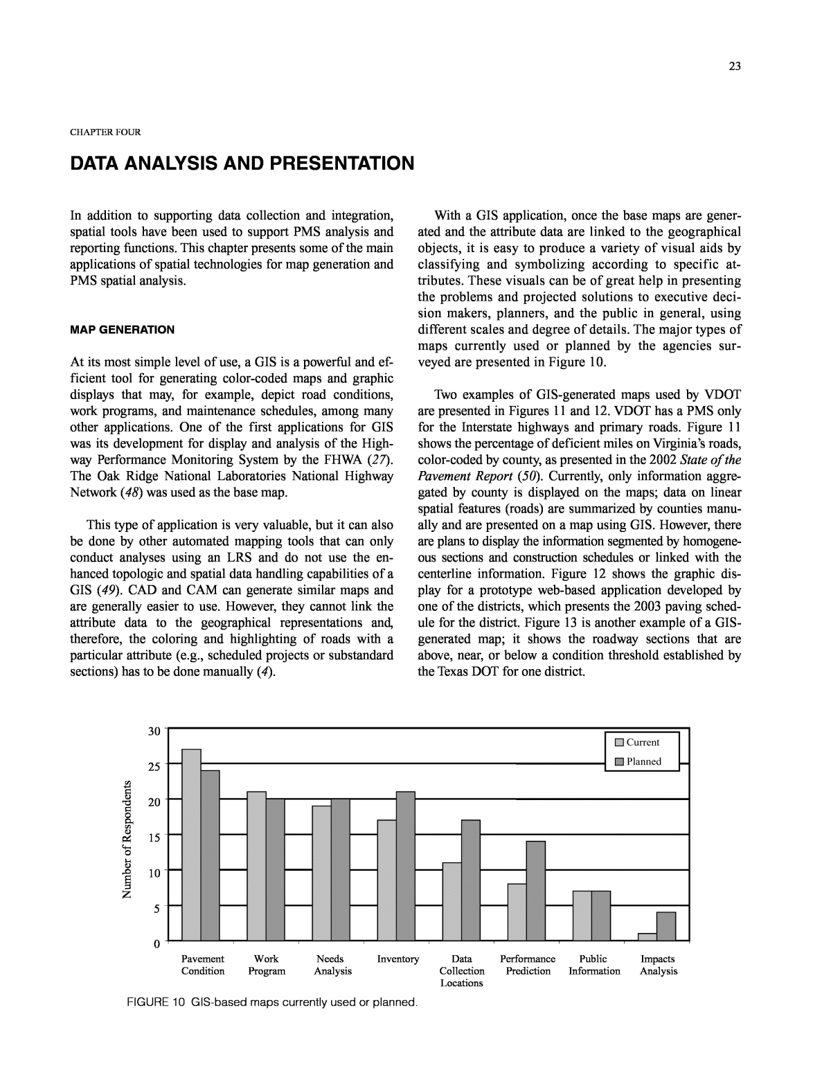
23 CHAPTER FOUR DATA ANALYSIS AND PRESENTATION In addition to supporting data collection and integration, spatial tools have been used to support PMS analysis and reporting functions. This chapter presents some of the main applications of spatial technologies for map generation and PMS spatial analysis. MAP GENERATION At its most simple level of use, a GIS is a powerful and ef- ficient tool for generating color-coded maps and graphic displays that may, for example, depict road conditions, work programs, and maintenance schedules, among many other applications. One of the first applications for GIS was its development for display and analysis of the High- way Performance Monitoring System by the FHWA (27). The Oak Ridge National Laboratories National Highway Network (48) was used as the base map. This type of application is very valuable, but it can also be done by other automated mapping tools that can only conduct analyses using an LRS and do not use the en- hanced topologic and spatial data handling capabilities of a GIS (49). CAD and CAM can generate similar maps and are generally easier to use. However, they cannot link the attribute data to the geographical representations and, therefore, the coloring and highlighting of roads with a particular attribute (e.g., scheduled projects or substandard sections) has to be done manually (4). With a GIS application, once the base maps are gener- ated and the attribute data are linked to the geographical objects, it is easy to produce a variety of visual aids by classifying and symbolizing according to specific at- tributes. These visuals can be of great help in presenting the problems and projected solutions to executive deci- sion makers, planners, and the public in general, using different scales and degree of details. The major types of maps currently used or planned by the agencies sur- veyed are presented in Figure 10. Two examples of GIS-generated maps used by VDOT are presented in Figures 11 and 12. VDOT has a PMS only for the Interstate highways and primary roads. Figure 11 shows the percentage of deficient miles on Virginiaâs roads, color-coded by county, as presented in the 2002 State of the Pavement Report (50). Currently, only information aggre- gated by county is displayed on the maps; data on linear spatial features (roads) are summarized by counties manu- ally and are presented on a map using GIS. However, there are plans to display the information segmented by homogene- ous sections and construction schedules or linked with the centerline information. Figure 12 shows the graphic dis- play for a prototype web-based application developed by one of the districts, which presents the 2003 paving sched- ule for the district. Figure 13 is another example of a GIS- generated map; it shows the roadway sections that are above, near, or below a condition threshold established by the Texas DOT for one district. FIGURE 10 GIS-based maps currently used or planned. 0 5 10 15 20 25 30 Pavement Condition Work Program Needs Analysis Inventory Data Collection Locations Performance Prediction Public Information Impacts Analysis N um be r of R es po nd en ts Current Planned
24 FIGURE 11 Interstate and primary pavement condition by county in Virginia. FIGURE 12 Web-based 2003 paving schedule for the NOVA District of the Virginia DOT.
25 FIGURE 13 Pavement condition score classes for one district of the Texas DOT.
26 14 Current 12 Planned N um be r of R es po nd en ts 10 8 6 4 2 0 Impact Work Program Inventory Condition Performance Needs Optimization/ Public Info Preparation Prioritization Assessment Prediction Analysis Analysis FIGURE 14 Number of agencies that use or are planning to use spatial analysis to support different pavement management functions. SPATIAL ANALYSIS Although the areas discussedâdata collection, data inte- gration, and map generationâhave been a fertile ground for the development of GIS-based PMS applications, the maximum pay-off for the use of the technology may be ob- tained by taking advantage of its spatial analysis capabili- ties. Figure 14 shows the number of agencies that use or are planning to use spatial analysis to support the different pavement management functions. Only a very limited number of states are currently using spatial analysis tools as part of the PMS decision-making process, mostly for in- ventory and condition assessment and, to a lesser degree, for needs analysis and optimization or prioritization of pro- jects. However, there are a significant number of states that are developing or planning PMS tools that use spatial analysis. The main applications include condition assess- ment, inventory, performance prediction, needs analysis, work program preparation, and project prioritization. STATE DEPARTMENT OF TRANSPORTATION EXAMPLES One of the first reported experiences of using GIS for PMS was an FHWA demonstration project conducted by the Wisconsin DOT in which two ongoing efforts to develop a GIS and a PMS were combined. The result was a prototype GIS-based PMS for one of the maintenance districts, which allowed the user to define homogeneous sections, assess pavement performance, identify problems based on that as- sessment, and recommend pavement improvements for correcting these problems. GIS functions were used to pro- vide dynamic segmentation capabilities to overlap cross sections, performance and improvement sections, and automatic map generation (51). The system determines the problems associated with each pavement section [nominal 1.6 km (1 mi) in length] and suggests a range of treatments for repairing all of the problems noted using a rule-based expert system. The pavement sections are then aggregated into improvement (homogeneous) sections, and the final treatment selected is based on five factors: improvement in ride, improvement in distress rating, user inconvenience, initial cost, and life-cycle cost. The projects are then priori- tized, and a 6-year improvement program and a 3-year maintenance program are recommended (52). Several other prototype PMS were developed in the mid-1990s. For example, Johnson and Demetsky (53) de- veloped a prototype GIS database for pavement manage- ment for two counties in Virginia and provided a frame- work for using a similar approach for other management systems. Osman and Hayashi (26) developed a prototype PMS coupled with a GIS composed of a spatial data base, an attribute data base, an analysis module, and an output generation module. Jia and Sarasua (54) developed a cli- ent/server enterprise-wide GIS, integrated with a Knowl- edge-Based Expert System by means of a computer net- work, and they demonstrated its use for a PMS. The Pennsylvania DOT developed a prototype GIS- based PMS for one engineering district, which has experi- ence in developing long-range plans for resurfacing, road- way widening, surface treatment, and guardrail upgrade programs. Some examples of specific GIS maps developed
27 include roadway inventory, planning compliance, surface improvement, roadway widening, roughness index, long- range improvement program, and crash cluster maps (55). Internationally, highway agencies are following similar paths. The Ministry of Transportation of Spain developed a GIS for highway management that can handle different types of data and different scales. The system allows for the grouping of different types of data, depending on the study to be performed, presenting the data in graphics and maps (56). Similarly, the Portuguese highway authority has implemented a PMS that uses a GIS for the generation of some of the input maps (57). With a few exceptions, the applications reported in the literature used the GIS capabilities for map generation only and, in a few cases, for database integration. However, state DOTs have started to take advantage of enhanced spatial analysis capabilities to develop more advanced PMS appli- cations. For example, the Ohio DOT used a GIS to deter- mine whether pavement performance differences exist among the 12 districts. Deterioration trends were devel- oped by transforming existing data into a probabilistic de- terioration model using GIS and relational database soft- ware (58). The Georgia DOT has developed and implemented a client/server and GIS-based pavement man- agement module that seamlessly integrates with the central database where the pavement condition survey data reside. Pavement condition data surveyed by field engineers are uploaded to the central database. The developed system al- lows managers to visualize statewide pavement conditions in real time and to perform spatial analyses by aggregating information with linear features into different jurisdictions, such as working districts. The implementation of the GIS module has enhanced pavement management capabilities by generating data that had previously been unavailable and by allowing faster access to the data (59). KDOT has developed several spatial PMS applications. For example, a GIS was used to relate weather data avail- able from point sources to their highway network to evalu- ate the effects of weather on pavement performance. The weather information from the National Oceanic and At- mospheric Administration was given for point stations. The information available for the point stations was assigned an effective radius of 20 mi and the resulting data were over- laid with the counties. This procedure permitted applying point data (such as the number of freezeâthaw cycles at a station) to a county and the highways within that county and studying the effect of weather; for example, rainfall, cold, heat, or freezeâthaw cycles, and pavement perform- ance history. Other examples include (R. Miller, KDOT, personal communication, June 30, 2003): ⢠Using a GIS to identify âredundantâ profile data to asses the variability of the data collection procedure, ⢠Assessing the feasibility of using FWD in network- level analyses by visualizing the coverage and distri- bution of FWD tests conducted over a period of 4 years, ⢠Identifying sample routes to evaluate provisional standards for pavement surface data collection, and ⢠Displaying remaining service-life estimations using PMS data at the network level to support the identifi- cation of reconstruction project locations. Another interesting application of spatial technologies for supporting PMS is the georeferencing engine that KDOT is developing to support automated field data col- lection activities. This system integrates several years of GPS data points to determine roadway location in a three- dimensional space by developing a complete highway spa- tial model with a level of fidelity that approaches that of design plans. This engine, combined with county bounda- ries, permits associating GPS with county milepost (LRS) on a route and expanding PMS data collection capabilities to enhance the agencyâs geometric database (60). EXAMPLES AT THE LOCAL LEVEL At the local level, counties and cities have developed many GIS-based applications for PMS and infrastructure man- agement systems. One important feature for local applica- tions is that GIS can help coordinate work among assets (61). A very large number of examples are available in the literature; selected examples include the following: ⢠Lee et al. (62) integrated a PMS with a GIS for a se- lected town in Rhode Island. The system included the following functions: performance prediction, network programming, and M&R alternatives selection. ⢠Lee et al. (63) developed a GIS-based PMS software to enhance pavement management for Salt Lake City, Utah. As part of this effort, a GIS was developed to enhance the existing PMS. The program reads pave- ment conditions, recommends appropriate mainte- nance strategies, and displays those strategies on a digital map. ⢠Medina et al. (64) combined a road surface manage- ment system with a GIS to develop a PMS for the town of Fountain Hills, Arizona. ⢠The city of Woodinville in Washington State devel- oped a low-cost GIS-based roadway facility informa- tion system (65). ⢠The Hillsborough County, Florida, Department of Public Works integrated its roadway centerline maps, inven- tory data, and pavement condition data using a GIS. Data collection was conducted using a van equipped with digital cameras. ⢠Ollerman and Varma (66) used GIS and CAD tech- nologies in an airport PMS.
