


Below is the uncorrected machine-read text of this chapter, intended to provide our own search engines and external engines with highly rich, chapter-representative searchable text of each book. Because it is UNCORRECTED material, please consider the following text as a useful but insufficient proxy for the authoritative book pages.
82 Chapter 8. Safety Framework to Assess the Impact of Railroad Crossings on Distraction Using the SHRP2 NDS Data 8.1 Introduction 8.1.1 Background This Safety Framework utilized SHRP2 NDS data. The SHRP2 NDS is the largest naturalistic driving study conducted worldwide to date, involving more than 3,000 male and female volunteer passenger vehicle drivers (ages 16 to 98) who participated from one to two years. The study included drivers from six U.S. states (Florida, Indiana, New York, North Carolina, Pennsylvania, and Washington). VTTI oversaw the data collection and curated the data collected for the various states, and VTTI continues to house the data in a secure data enclave. Data were collected in-vehicle from October 2010 to November 2013 (Dingus et al. 2014). The vehicle instrumentation package (DAS) included a camera array, accelerometer, radar, GPS, and CAN bus to extract engine variables. Vehicle kinematic data such as speed, acceleration (forward and lateral), brake status, and gas pedal position were recorded or extracted. Vehicle kinematic data can be provided in a data file with variables correlated to 0.1-second intervals. The video views include forward roadway, rear roadway, driverâs face, and over the driverâs shoulder. The GPS data can be used to link vehicle position with a roadway database, which can be used to identify driving activity in the vicinity of infrastructure elements of interest. A more in-depth description of the data set is provided in Section 4.4.1. The main advantage of using NDS data for the evaluation of IRDs is that driver behavior can be linked to actual events (normal or safety critical) and roadway characteristics. Another advantage is that when driver face video is collected, glance location can be reduced to assess where drivers were looking during events of interest. Other surrogates for distraction, such as lane position, standard deviation of lane position, speed, and standard deviation of speed, can also be extracted. Data can then be compared for roadway segments with and without the infrastructure feature of interest. The main disadvantage in the use of this type of data is that finding events of interest can be a âneedle in a haystackâ problem because these events may represent a few seconds out of the hundreds of hours of data collected. 8.1.2 Scope of Framework The Safety Framework described in this chapter was developed to evaluate the impact of railroad crossings on distraction using data from the SHRP2 NDS. Railroad crossings were selected because there has been some evidence of distraction at railroad crossings, crossings are easily located in the SHRP2 NDS data set, and they are uncommon enough that drivers are likely to behave differently in their presence.
83 Tung (2014) conducted through the windshield observations at railroad crossings in Nebraska and found that approximately one-third (33.6%) of the drivers appeared to be distracted. Of the distractions observed, 13.9% were visual distractions, 25.8% were manual distractions, and 52.3% involved talking to passengers. Thus, about 4.7% of the drivers overall were deemed to be distracted by visual stimuli outside their vehicles. Although the distractions were not specifically tied to railroad crossing structures, the study provided some evidence that crossings have been considered in the context of OVDs. The following general list of research questions relevant to assessing driver distraction due to railroad crossings was formulated: ⢠Is there a relationship between railway structures and OVDs or other measures of distraction such as lateral control or steering behavior? ⢠Are certain drivers (e.g., younger drivers) more likely to be distracted by railroad infrastructure elements? ⢠What is the relationship between the presence of railroad infrastructure and driver glance performance? ⢠What is the relationship between the presence of railroad infrastructure and surrogate distraction behaviors? One research question was selected as the most feasible given the available data and project objectives and was the focus of this Safety Framework: What is the relationship between the presence of railroad infrastructure and driver glance performance? 8.2 Data Sets Utilized Several data sets were utilized to develop the Safety Framework, as described in this section. Data acquisition and data reduction are discussed in the following section. 8.2.1 Curated SHRP2 NDS Data Sets VTTI provides access to SHRP2 NDS data sets that were curated for other researchers. These can be obtained at low or no cost through a data request. Each record in the data sets typically provides a time series trace (speed, acceleration, position, and other kinematic vehicle characteristics at 0.1-second intervals), a forward roadway view video, and a rear roadway view video. In some cases, reduced data such as glance location or distraction are available. Data set descriptions on the SHRP2 NDS website, InSight (https://insight.shrp2nds.us/), were reviewed to identify those that may contain railroad crossings, and several were selected. Each was reviewed, and the following two existing SHRP2 NDS data sets were determined to be the most feasible for project purposes: ⢠Driver Behavior at Highway-Rail Grade Crossings Using Naturalistic Driving Study Data (doi:10.15787/VTT1/KWUKGM). These data had been provided to Michigan Technological University. Vehicle traversals at intersections included an area extending 600 ft prior to a grade crossing, through the crossing, and 200 ft beyond the crossing.
84 ⢠Rail-Highway Grade Crossings âPhase 3 (doi:10.15787/VTT1/3YVSY4). These data had been provided to Michigan Technological University, whose research team investigated railroad crossings, driver reactions to existing traffic control devices, and the impacts of the crossing environment, including weather, time of day, and driver familiarity with the crossing. An example of a railroad crossing in the SHRP2 NDS data is shown in Figure 18. Source: VTTI Figure 18. Forward video view at a railroad crossing. 8.2.2 Safety-Critical Events Another source of existing SHRP2 NDS data is a data set of around 8,790 crashes, near-crashes, or conflicts (SCEs) that VTTI identified and coded. A crash is defined as any event where the subject vehicle makes contact with a moving or fixed object in which kinetic energy is measurably transferred or dissipated or the subject vehicle leaves the roadway with at least one tire. A NC includes events involving a rapid evasive maneuver by the subject vehicle or a conflicting vehicle, pedestrian, cyclist, or animal in order to avoid a crash. A conflict is an event that requires an evasive maneuver that is less urgent than that required for a NC but more urgent than the maneuvers required for normal driving. Coded information includes pre-event and post-event vehicle maneuvers, an assessment of fault, severity, driver actions in response to the event (e.g., passing on the right), precipitating event, vehicle contributing factors, and driver state (e.g., impairment, emotional state). Distraction is also coded (in terms of the beginning and end time for the distraction as well as the type of distraction) for up to three activities. Roadway surface condition, basic roadway characteristics (e.g., number of lanes, presence of traffic control, alignment), and a measure of traffic flow are also included in the data. Time series data and a forward roadway video clip are available for each SCE and are housed on the SHRP2 NDS website, InSight (https://insight.shrp2nds.us/). Other information can be extracted for SCEs if needed. For instance, the presence of relevant infrastructure items can be coded using the forward video or the RID.
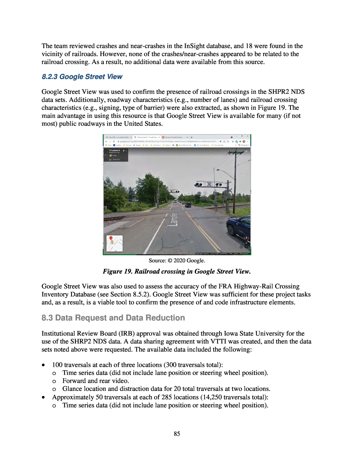
85 The team reviewed crashes and near-crashes in the InSight database, and 18 were found in the vicinity of railroads. However, none of the crashes/near-crashes appeared to be related to the railroad crossing. As a result, no additional data were available from this source. 8.2.3 Google Street View Google Street View was used to confirm the presence of railroad crossings in the SHPR2 NDS data sets. Additionally, roadway characteristics (e.g., number of lanes) and railroad crossing characteristics (e.g., signing, type of barrier) were also extracted, as shown in Figure 19. The main advantage in using this resource is that Google Street View is available for many (if not most) public roadways in the United States. Source: © 2020 Google. Figure 19. Railroad crossing in Google Street View. Google Street View was also used to assess the accuracy of the FRA Highway-Rail Crossing Inventory Database (see Section 8.5.2). Google Street View was sufficient for these project tasks and, as a result, is a viable tool to confirm the presence of and code infrastructure elements. 8.3 Data Request and Data Reduction Institutional Review Board (IRB) approval was obtained through Iowa State University for the use of the SHRP2 NDS data. A data sharing agreement with VTTI was created, and then the data sets noted above were requested. The available data included the following: ⢠100 traversals at each of three locations (300 traversals total): o Time series data (did not include lane position or steering wheel position). o Forward and rear video. o Glance location and distraction data for 20 total traversals at two locations. ⢠Approximately 50 traversals at each of 285 locations (14,250 traversals total): o Time series data (did not include lane position or steering wheel position).
86 o Forward and rear video. o A limited number of distractions coded for several thousand traversals but not including glance location or type of distraction. All of the traversals included an area extending about 600 ft prior to a grade crossing, through the crossing, and 100 to 200 ft beyond the crossing. Glance location was utilized as the measure of distraction for this Safety Framework. Since glance location was only available for 20 traversals, they were the focus of data reduction and analysis. The presence of a railroad crossing in each of the traversals utilized was confirmed. The following variables were reduced for each trace: ⢠Time of data (e.g., day, night): Reduced from forward traversal video. ⢠Ambient (e.g., dry, rain): Reduced from forward traversal video. ⢠Presence of on-street railroad crossing signing. ⢠Type of railroad crossing-related signing (e.g., W10-1): Google Street View. ⢠Number of tracks: Google Street View. ⢠Other railroad traffic control devices (e.g., beacons): Google Street View. ⢠Type of barrier (e.g., mast arm): Google Street View. The location of railroad crossing features (e.g., signing, tracks, barriers) was identified in the forward video for each traversal. The location of each feature was marked at the approximate point in the corresponding video when the subject vehicle was even with the element and noted in the corresponding timestamp. Accordingly, the distance of the subject vehicle from each infrastructure element could be calculated at any point (e.g., to determine glance location 200 ft upstream of the railroad crossing), as illustrated in Figure 20. Figure 20. Location of train tracks noted as vehicle crossing at timestamp #51776.
87 8.4 Analysis 8.4.1 Variables Included The use of several dependent variables was investigated. Various dependent variables were considered because they can provide different information. For instance, glance location was considered as a dependent variable because it can be used to infer where drivers are paying attention. The proportion of time a driver glances in a particular location could also be used as a dependent variable. Glance location was provided with the VTTI data sets for the subset of traversals utilized. Glances were coded as follows: ⢠Cell phone (glance to a cell phone regardless of where the cell phone is located). ⢠Center stack (center area with radio, climate control, etc.). ⢠Forward (forward roadway in direction of travel). ⢠Instrument cluster (dashboard directly in front of driver, including such features as speedometer, controls, or steering wheel). ⢠Interior object (glancing inside the vehicle at an object not included in other categories). ⢠Left window/mirror (left side window or mirror). ⢠Left windshield (left portion windshield, not directly in direction of travel). ⢠No eyes visible â eyes-off-road (coder unable to determine exact glance location but glance location not related to driving task). ⢠No eyes visible â glance location unknown (usually indicates that coder could not see driverâs eyes or infer glance location). ⢠Rear view mirror (rear view mirror or vicinity). ⢠Right window/mirror (right side window or mirror). ⢠Right windshield (right portion of forward roadway, not directly in direction of travel). Glances were coded with a start time and end time using the video timestamp. As a result, the number of times a driver glanced at a particular location and the length of each glance was determined. Glance location was used as a surrogate for distraction. Drivers distracted by railroad features may be expected to focus their glance on a specific feature for an extended period of time or move their focus from other locations differently than if not distracted. The main railroad features that were expected to cause distraction were overhead structures or crossbar structures to the left or right. As a result, the distraction metrics included the proportion of the time drivers spent looking forward or to the left/right of the windshield when in the vicinity of the railroad crossing compared to the time drivers spent glancing at those same locations when not influenced by the crossing (upstream). Additionally, Liang and Lee (2010) noted that cognitive distraction disrupts the allocation of visual attention to the driving scene and can cause drivers to concentrate their gaze in the center of the driving scene. A driver fixating in one location of the windshield may thus also indicate distraction in relation to an infrastructure element. As a result, the proportion of time looking straight was also used as a surrogate for distraction. The
88 proportion of time was used rather than actual time because the time each driver was within the influence area of the railroad crossing or the upstream control area differed. Other metrics to approximate distraction were also considered. Lane position, standard deviation of lane position, steering wheel position, speed, and standard deviation of speed have been utilized as measures of driver cognitive workload and distraction, as noted in Section 2.3. Lane position and steering wheel position are captured in the SHRP2 NDS data and therefore can be included in data requests. However, neither lane position nor steering wheel position was provided for any of the traversals in the curated data set utilized for this analysis. As a result, these metrics could not be evaluated. Speed was not utilized because drivers may be expected to slow their vehicles as they approach a railroad crossing, and therefore a reduction in speed would not necessarily indicate distraction. A distance of 200 ft upstream of the railroad crossing was used as the railroad influence area. This was based on an assumed legibility distance of 180 ft for a static sign and correlates to the distance at which signing and other crossing structures would be visible to an approaching driver. A section upstream of the influence area was available for each of the traversals and was used as the control portion of the analysis. Due to the short distance within the influence area, it was not feasible to use glances of 2 or more seconds as the metric of interest. The metrics utilized as dependent variables included the following: ⢠Proportion of the time spent glancing at the forward roadway within the influence area compared to the time spent glancing at the forward roadway within the control sections. ⢠Proportion of the time spent glancing at the left or right windshield within the influence area compared to the time spent glancing at the left or right windshield in the control sections. Dependent variables included the following: ⢠Time of day (day, night). ⢠Weather (dry, rain). ⢠Railroad crossing ID (used to account for repeated samples). ⢠Driver ID (used to account for repeated samples). ⢠Driver age. ⢠Type of railroad crossing control (e.g., mast arm). ⢠Number of tracks. ⢠Upstream traffic control devices specific to railroad crossings (e.g., warning signs, on- pavement railroad markings). A total of 20 unique traversals through two railroad crossing were available, as noted in Section 8.3. 8.4.2 Modeling Approach and Results An exploratory analysis of the data was conducted. Figure 23 (top) shows the proportion of time drivers are looking at the forward windshield within the railroad crossing influence area compared to the upstream control area. Twenty observations were available for the influence
89 area, and 20 observations were available for the control area. As the figure shows, drivers are glancing forward approximately 80% of the time in the influence area compared to around 74% in the control section. Figure 21 (bottom) shows the proportion of time drivers are glancing at the left or right sides of the windshield in the influence area (approximately 12%) compared to the upstream control area (approximately 14%). Figure 21. Proportion of time drivers are glancing at the forward (top) or left/right (bottom) areas of the windshield. The expected outcome is a difference in glance location between the railroad crossing influence area and upstream control area. As a result, the statistical model utilized needed to detect those differences as well as the impact of other covariates. Additionally, the exploratory analysis indicated the data did not follow a normal distribution. Due to the small sample size and lack of normality, a Wilcoxon signed rank test for paired differences was used as a nonparametric alternative to other tests, such as a t-test. When applied to the differences in the proportion of forward glance time, the results of the test show a significant difference. The results of the model indicate there is a modest difference between the amount of time a driver looks at the forward roadway in the railroad crossing influence area compared to the upstream control area (a p-value of 0.01842). The difference suggests that drivers focus more on the forward roadway when approaching railroad crossings. This behavior could be positive (attention to traffic control devices) or negative (fixation on railroad crossing infrastructure rather than other roadway elements).
90 When the model was applied to the proportion of time drivers spent glancing at the left/right windshield within the influence area compared to upstream control area, the results were not statistically significant (a p-value of 0.1259). Due to the small sample size, the results of the model could not detect an impact due to covariates for either condition. Additionally, within-subject variability could not be accounted for. With more data available, more population assumptions can be made and differences better indicated in the model outcome. With additional data, one appropriate method that could be used for analysis is a linear mixed effects regression model. A linear mixed effects model has two main components: a fixed effects part and a random effects part. The fixed effects consist of the independent variables meant to explain the dependent variable, such as number of lanes, time of day, or presence of beacons, lighting, or pavement markings. The random effects model the variability introduced by groupings of variables, such as railroad crossing site (if there are multiple traces per crossing) or driver ID (if there are multiple traces per driver). Another modeling technique could take advantage of the fact that the difference in forward glance proportion is bounded by -1 and 1. Beta regression with mixed effects is suitable for cases when the response variable has lower and upper bounds, and thus it could be used to improve upon the regular linear mixed effects model. Another dependent variable that could be utilized with sufficient data is the number of glances away from the road. This variable can be modeled with a Poisson regression with mixed effects. The location of the vehicle (more than 200 ft or less than 200 ft from a railroad crossing) would be an independent variable. 8.5 Outcomes and Discussion 8.5.1 Summary A preliminary analysis was conducted to evaluate the impact of railroad crossing infrastructure elements on distraction. A curated SHRP2 NDS data set that includes traversals through railroad crossings was utilized. Twenty traversals containing glance location information upstream of railroad crossings were reduced, and glance location was used as a surrogate for distraction. Collecting additional data was beyond the scope of the project, and, as a result, modeling options were limited due to the small sample size. However, a Wilcoxon signed rank test for paired differences was used to compare glance behavior within an influence area 200 ft from the railroad crossing to glance behavior within a section upstream that was used as a control. The model indicated that the proportion of time drivers glanced at the forward windshield was higher and statistically different within the influence area, while the results were not significant for the proportion of time glancing at the left or right windshield. The difference identified for the proportion of time drivers spent glancing at the forward windshield suggests that drivers focus more on the forward roadway when approaching railroad crossings. This behavior could be positive (attention to traffic control devices) or negative (fixation on railroad crossing infrastructure rather than other elements of the driving task).
91 The results suggest that a difference between glance behaviors can be detected in the vicinity of railroad crossings. It should be noted that no trains or indications of an approaching train were present in any of the traversals included in the analysis. 8.5.2 Performance Metrics Performance metrics suitable for measuring the success of the research activities and outputs were identified and are described below. Feasibility of the Data Sets Utilized This analysis used a reduced data set from the SHRP2 NDS. Naturalistic driving studies are well suited for this type of analysis because driver behavior can be compared for similar roadway environments within the influence area of and away from the infrastructure element of interest. Additionally, driver behavior can be captured when face position video data are collected. The SHRP2 NDS data were uniquely suited to this analysis because the data set represents a large number of drivers over multiple years on a variety of roadway conditions. In particular, around 283 railroad crossings were already identified and confirmed in a prior research project; these data were available through the VTTI secure data enclave. Another advantage to the SHRP2 NDS data set is that several metrics are available that can be used as surrogates for distraction. While not provided in the curated data sets utilized, lane position metrics, including distance to the right or left lane, can be included in data requests. Lane position variables were collected along with the time series data during the SHRP2 NDS project. These variables include âOffset from Center of Lane,â âLane Width,â and the track width of the vehicle. A variable is also provided that provides some measure of accuracy of the lane tracker. Lateral position, including lane departure, is calculated using the offset from the center of the lane, lane width, and vehicle track width. Speed is also provided in the time series data. Speed can be calculated for a position upstream and downstream of the infrastructure element of interest. Lane position and speed variables are typically provided at 0.1-second intervals. Several other existing NDS data sets were discussed in Section 4.1. In many cases, sample size is limited in terms of number of the drivers and amount of actual driving data collected. Additionally, many are collected as FOTs for a specific purpose and may not contain the breadth of driving scenarios available in the SHRP2 NDS data set. Another drawback to other NDS data sets is that most were not created for widespread use by researchers outside the originating research institution and, as a result, are difficult to access. The one advantage to some NDS data sets is that glance location is recorded using eye tracking equipment, which is superior to coding glance location using a forward face video. Overall, the SHRP2 NDS data set is more than adequate for the purposes of evaluating the impacts of common roadway infrastructure elements such as railroad crossings. However, the SHRP2 NDS only involved passenger vehicles. As a result, the impact of large trucks or motorcycles cannot be assessed.
92 Roadway elements other than those specific to railroad crossings were obtained via Google Street View, which was sufficient for identifying general roadway characteristics. The number of railroad crossings included was limited, and, as a result, it was reasonably simple to locate the crossing and then confirm the accuracy of the information using forward video in the SHRP2 NDS traversals. However, if a much larger number of railroad crossings were included in an analysis, manual reduction of roadway elements would be time consuming. Roadway information may also be obtained from the SHRP2 RID, the data for which were collected in conjunction with the SHRP2 NDS. A mobile data collection van was used to collect data for about 12,500 centerline miles in the six SHRP2 NDS states. Other sources of existing data were collected and incorporated into the RID. GPS data can be used to link vehicle position with the information in the RID, which can be used to identify driving activity in the vicinity of infrastructure elements of interest. Additionally, other roadway characteristics from the RID can be extracted (e.g., grade, speed limit, roadway type). Some roadway variables can also be extracted from the forward roadway views available with the SHRP2 NDS data. The forward roadway view can also be used to confirm the presence and characteristics of desired roadway elements that correspond to the vehicle activity of interest. One drawback to the RID is that railroad crossings were not coded in the mobile mapping data and were not obtained from agencies as part of the supplemental data. As a result, it would be necessary to rely on another data source to increase the number of railroad crossings included. Approximately 290 railroad crossings were identified in the curated SHRP2 NDS data sets utilized in this analysis. However, researchers may wish to increase the sample size or identify other railroad crossing locations. The research team evaluated the efficacy of using the FRA Highway-Rail Crossing Inventory Database for this purpose. The FRA database was created and is maintained by the Federal Railroad Administration. The inventory provides information on all railroad crossings in the U.S., including both public crossings (streets, highways, pedestrian paths, bike trails, etc.) and private crossings (driveways, farm access lanes, private roads, etc.). The database contains information on location, traffic control devices present, number of trains per day, and so on. However, because the data are self-reported, the entries in the inventory are at times incomplete, and the accuracy of information is difficult to verify (FRA 2020). The team accessed the data via the FRA data portal (https://railroads.dot.gov/crossing-and- inventory-data/grade-crossing-inventory/highwayrail-crossing-database-files). The evaluation included extracting railroad crossings for the state of New York, which is included in the SHRP2 NDS, and resulted in 1,253 datapoints. The railroad crossings were integrated into a Google map, and 70 crossings were examined in more detail using Google Street View. Railroad crossing characteristics in Google Street View were compared to those in the FRA database to determine the latterâs accuracy. Half (35) of the crossings selected from the FRA database were railroad crossings and were located in close proximity to the indicated location. Half (35) were no longer present, were located along an existing railroad but did not represent a crossing, or were duplicates. As a result, the FRA data had an accuracy of 50%. Although low, it is likely sufficient to identify additional railroad crossings if needed.
93 Additionally, ArcGIS maintains a spatially located grade crossing inventory that originates from the FRA inventory. The ArcGIS data set also contains Amtrak stations and Amtrak routes (ArcGIS 2020). Sample Size As noted in Section 8.3, only 20 traversals through railroad crossings were available in the data sets used for this analysis. This resulted in 40 datapoints (20 upstream and 20 at the railroad crossing). As a result, it was difficult to determine statistical significance for independent variables. However, it is presumed that the following independent variables are relevant and should be included in similar modeling efforts: ⢠Driver age. ⢠Type of vehicle (e.g., passenger vehicle, large truck). ⢠Type of railroad crossing control (e.g., overhead structure, beacons, different types of railroad crossing arms). ⢠Presence of other supplemental traffic control at railroad crossings. ⢠Number of tracks. ⢠Upstream traffic control devices specific to railroad crossings (e.g., warning signs, on- pavement railroad markings). ⢠Time of day (night versus day). ⢠Lighting. ⢠Speed limit. The above variables represent at least 25 different factors. Using an estimate of 50 samples per factor, a sample size of an approximately 1,250 traversals is needed. It may be advantageous to restrict observations to only daytime or nighttime dry conditions. Light conditions for dawn/dusk are difficult to categorize, and adverse weather is likely to impact driver behavior in general, which may be difficult to account for in an analysis. Additionally, countermeasures to address driver distraction are not selected for specific weather conditions. The curated data sets for railroad crossings used in this project were made via a data request to VTTI and included 50 traversals at each of 285 locations (14,250 traversals in total). It is expected that these data would be more than sufficient for analysis. As noted, lane position and steering wheel position variables were not included in the archived data. As a result, it would be necessary to request these fields if lane position or standard deviation of lane position were used as surrogates for distraction. Additionally, glance location would need to be reduced for at least 1,250 additional traces. The location of railroad infrastructure (e.g., signing, track, beacons) would also need to be reduced for each traversal in order to determine vehicle position in terms of railroad elements. The FHWA has developed some tools that may be of use in this regard. If additional railroad crossings were needed, over 1,200 railroad crossing were identified for New York alone in the FRA Highway-Rail Crossing Inventory Database. Although approximately 50% of the samples evaluated did not accurately represent current railroad
94 crossings, there would be more than sufficient additional locations that could be mapped to the SHRP2 NDS data to identify additional traversals. As a result, sufficient data are available to increase the sample size through the collection and reduction of additional data. Moreover, the framework presented for analysis using the SHRP2 NDS data can be applied to other NDS data sets. Performance of Statistical Models Because the analyses were used as proofs of concept to guide the development of the Safety Framework, sample sizes were limited to existing data that could be obtained within project resources. Due to these sample size limitations, only simple metrics such as p-value could be used to assess the performance of the models. Additionally, due to the small sample size, the impact of covariates could not be determined. However, the models did indicate differences in driver glance location between areas upstream from or near railroad crossings, suggesting that a relationship could be derived. With additional data, a linear mixed effects model would be more appropriate because it can account for random effects. The dependent variables for the present analysis were the proportion of time drivers spent looking at the forward windshield or at the left/right windshield. Because most railroad elements would only be visible to drivers for a set distance (e.g., 180 ft for a static sign), it would be difficult to use glance length (e.g., 2 or more seconds) to measure distraction. To account for this challenge, differences in driver behavior were compared between an area near the railroad crossing and an area upstream where roadway conditions were similar. Other surrogates for distraction could include lane position, standard deviation of lane position, and steering wheel position. 8.5.4 Discussion The objective of this framework was to assess the efficacy of using SHRP2 NDS data to evaluate distraction due to railroad infrastructure elements. Although the sample size used for this evaluation was small, the results indicate that drivers do glance differently when in the vicinity of a railroad crossing (without a train present). The evaluation also indicated that railroad crossing data can be obtained from several sources, which would thus provide the ability to identify a variety of different railroad crossing configurations. As a result, further analysis of distraction related to railroad crossings is feasible. This framework can also be used to explore the relationship between distraction and other roadway features using the SHRP2 NDS data. The main advantages of using the SHRP2 or other NDS data include the following: ⢠Driver behavior can be linked to actual events (normal or safety critical). ⢠Some curated SHRP2 NDS data sets are available that may reduce costs in accessing data. However, they may not include the elements of interest. As a result, the cost to reduce additional data should be considered. ⢠Various surrogate measures can be used, including glance location, lateral position, and speed.
95 ⢠Driver behavior can be compared for roadway segments with and without the infrastructure element of interest (for instance, a segment upstream of an overhead changeable message sign and a segment in the vicinity of the sign). The main disadvantages include the following: ⢠Access to the SHRP2 NDS data is costly if the use of curated data sets is not feasible. ⢠Only passenger vehicles are included in the SHRP2 NDS data. ⢠Finding events of interest can be a âneedle in a haystackâ problem. ⢠The use of the SHRP2 NDS data can be expensive, and collecting new NDS data is cost- prohibitive if it is uncertain that the data set is able to detect IRD. Use of the SHRP2 NDS data for an analysis of IRD is likely best suited to infrastructure elements that are available in an existing database such as the RID, a state roadway database, or another data source. Such infrastructure elements include bridges, overpasses, directional signing, and, when sufficient information is available, railroad crossings or wind turbines. Finding other elements of interest, such as locations where pedestrian hybrid beacons are present, would be more challenging. The SHRP2 NDS data are also best used to analyze infrastructure elements that can be observed distinctly away from other roadway features that may also have an impact on distraction. Finally, the SHRP2 NDS data could be used to assess the impact of roadway design (such as combinations of horizontal and vertical curvature) on distraction by comparing glance behavior in different scenarios.
