
4
Science and Applications
INTRODUCTION
The acquisition of new scientific data usually involves the development of new sensor and processing technologies. A key tenant of the Hybrid Space Architecture (HSA) is that the demand for new data will drive innovation, and broaden the spectrum of space technology, which allows entry of new players as part of the New Space ecosystem. As discussed in this chapter, and further examined in Chapter 5, a healthy and growing New Space ecosystem driven by HSA and other government needs, when enabled by incentivized commercial partnerships, offers the potential benefits of lower cost and faster response at every level of the space system business. This ranges from basic parts to integrated systems as well as “bundles” including turnkey support all the way through launch services. A healthy SmallSat ecosystem will not only permit an increased pace of scientific development and exploration but will also open the door to new players, including nontraditional users, to populate the information layers within the architecture. Thus, there can be a natural synergy with mutual benefits between HSA and enabled science stakeholder communities.
Science, until now, has generally relied on traditional mission-unique architectures to provide either a singular mission flight opportunity or aggregated sensors as part of a large, dedicated mission. While some missions will still require a traditional system approach, SmallSats introduced through commercial opportunities and partnerships can provide more flight opportunities and faster access at lower cost for science applications. Advanced technologies and sensor innovations within ongoing programs have demonstrated that high-quality data can be obtained in many applications at lower cost and faster cadence. Thus, a healthy and well-managed ecosystem will benefit the science user and allow ideas to more quickly and efficiently transition to deployed government or commercial constellations capable of collecting information required by national and local decision-makers.
EMPLOYING SMALLSATS FOR EARTH OBSERVATION
Remote sensing of the Earth and of other planetary bodies is performed by satellites whose orbital characteristics differ with regard to the temporal, spatial, and spectral resolutions imposed by the mission objectives. As related in the 2016 National Academies report Achieving Science with CubeSats,1 a low Earth orbit (LEO) satellite
___________________
1 National Academies of Sciences, Engineering, and Medicine, 2016, Achieving Science with CubeSats: Thinking Inside the Box, Washington, DC, The National Academies Press, https://doi.org/10.17226/23503.
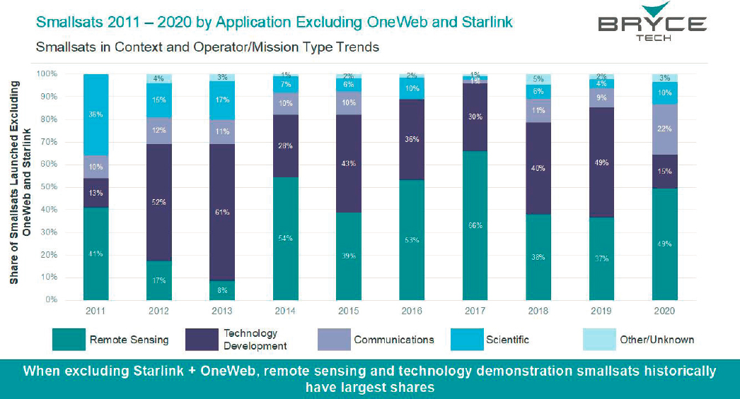
provides high spatial resolution imaging but poor temporal coverage (unlike a geostationary satellite that provides diurnal—or better—temporal coverage but reduced spatial resolution). To date, most SmallSats in LEOs have been developed for technological development and surface imaging purposes rather than for scientific applications that require accurate and reliable calibration of the data products,2 but the situation has been evolving and growing on many commercial and technology fronts, as illustrated in Figure 4.1 for the 2011–2020 time span.
Observing the Earth system and its evolution is a great challenge considering the multitude of processes occurring in the atmosphere, hydrosphere, biosphere, and solid Earth, and their complex mutual interactions on a broad range of spatial and temporal scales. For more than three decades, NASA and other space agencies worldwide have launched multiple large and small traditional space missions in different orbital inclinations and altitudes, carrying a large variety of instruments for monitoring weather patterns; atmospheric dynamics and composition; ocean circulation and sea state; climate change and variability; land and marine ecosystems; land use change; water; energy and carbon cycles; solid Earth rotation and deformations; gravity and magnetic fields; as well as other processes.
The contributions of all of these missions have been invaluable and fundamental to understanding the Earth system and its evolution under natural and anthropogenic force at an individual discipline science level and also at an integrated Earth system science level. The system science approach producing a diverse range of data products is becoming ever more important, especially to feed models developed to predict/project future changes and their associated societal impacts. Thus, the Earth science community is now positioned to fully benefit from the added data opportunities afforded by smaller, faster, and less-expensive missions based on advanced technology miniature sensors flown on SmallSats.
___________________
2 R.M. Millan R. von Steiger, M. Ariel, S. Bartalev, M. Borgeaud, S. Campagnola, J.C. Castillo-Rogez, et al., 2019, Small satellites for space science: A COSPAR scientific roadmap, Advances in Space Research 64(8):1466–1517.
However, while the potential for a higher volume of SmallSat missions including constellations for science (in particular, Earth and heliophysics science) is enormous and promising, it is recognized that they do not replace larger missions but rather complement them. SmallSat missions allow new approaches and new measurements that can be transitioned from conception to flight on shorter time scales. The potential benefits are substantial in many cases, owing to lower cost but also a faster and potentially broader scientific set of results, shorter development times, and more frequent mission opportunities combined with the capability of fielding satellite constellations.
All of the above are important benefits of SmallSat technology, but the ability to deploy multiple satellites either on the same orbit or in different orbital planes is a true game-changer by allowing observations with increased spatial and temporal coverage. Satellites in different orbital planes improve both the spatial coverage of the Earth surface and the frequency of data acquisition, while satellites in the same orbital plane essentially increase the temporal resolution. Closely spaced satellites also allow for the possibility of making nearly simultaneous measurements at multiple viewing geometries. Almost all areas of Earth science can benefit from such SmallSat constellations including weather forecasting, climate monitoring, detection and tracking of natural and human-induced disasters, water resources management, urban and coastal zones surveys, and so on. Several examples are discussed in the rest of this chapter.
Long-Term, Sustained Measurements for Climate Monitoring
SmallSats allow for new opportunities to reduce uncertainties in forecasting Earth’s climate future through the use of multi-satellite constellations that are affordable, persistent, and upgradeable. The ability to launch up to hundreds of SmallSats over relatively short time periods, at reasonable cost, now means that data gaps common to traditional large, single spacecraft approaches, with multi-day revisit times, can be mitigated. While the impact of short revisit times with SmallSats is phenomenon-dependent, the true benefit of this approach is the ability to achieve accurate sustained measurements over long time periods. Using platforms that can support multiple instruments, or varying single instrument spacecraft with multiple instrument types, these approaches also allow for new products to be generated through data fusion techniques as well leading toward a capability that can help resolve long-standing questions in several fields of climate science. Furthermore, the technology used to sustain continuous observations introduces benefits for science including autonomous observation tasking, real-time data collection and analysis, large-scale satellite intercalibration to reduce aggregate measurement biases, and improvement of simulation models. This is particularly beneficial in oceanography, where the impact of rapidly changing phenomena (e.g., small eddy formation) can have a significant effect on longer-term processes (e.g., ocean circulation heat transport). As another example, constellations of SmallSats can provide more frequent sampling of extreme weather conditions. Frequent measurements of ocean surface winds and latent heat flux by the Cyclone Global Navigation Satellite System (CYGNSS) constellation prior to the rapid intensification phase of tropical cyclones can significantly improve the prediction of both their inner core wind structure3 and their track.4 More frequent measurements over land can also provide valuable predictive information. CYGNSS measurements of soil moisture are able to track sub-daily water cycle dynamics, which significantly improves global land surface models.5 This is also true for many other areas in Earth observation, such as hydrology and coastal zone change monitoring.
Improved Temporal Sampling
The revisit time provided by a SmallSat constellation in LEO will scale with the number of satellites (designated as “N” in this discussion), provided their orbits are properly phased. N satellites can revisit N-times more frequently than a single satellite, reducing the 3-day revisit time typical of many medium-swath-width polar orbiting
___________________
3 Z. Cui, Z. Pu, V. Tallapragada, R. Atlas, and C.S. Ruf, 2019, A preliminary impact study of CYGNSS ocean surface wind speeds on numerical simulations of hurricanes, Geophysical Research Letters 46(5):2984–2992, doi: 10.1029/2019GL082236.
4 M.J. Mueller, B. Annane, M. Leidner, and L. Cucurull, 2021, Impact of CYGNSS-derived winds on tropical cyclone forecasts in a global and regional model, Monthly Weather Review 149(10):3433–3447, doi: 10.1175/MWR-D-21-0094.1.
5 H. Kim, V. Lakshmi, Y. Kwon, and S.V. Kumar, 2021, First attempt of global-scale assimilation of subdaily scale soil moisture estimates from CYGNSS and SMAP into a land surface model, Environmental Research Letters 16:074041, doi: 10.1088/1748-9326/ac0ddf.
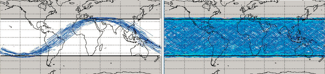
imagers to 3 hours with a constellation of 24 satellites. As a specific example, the mean revisit time for measurements by the Global Navigation Satellite System Reflectometry (GNSS-R) bistatic radar on a single SmallSat in the CYGNSS constellation is ~2 days. This is reduced to ~7 hours for the full constellation of 8 spacecraft.6 The spatial coverage provided by a single spacecraft can be similarly improved upon with a constellation. The spatial coverage over time provided by CYGNSS is illustrated in Figure 4.2. Coverage by the full constellation over a single 95-minute orbit is shown on the left and coverage over 24 hours (about 15 orbits) is shown on the right. Notably, the dense daily spatial coverage includes multiple samples per day within ¼ × ¼ degree grid cells, with a mean time between samples of 7.2 hours.
Rapid-refresh, low revisit time measurements are necessary to resolve short time scale dynamics—for example, extreme precipitation events, tropical cyclones, and flooding. While archival records of well-sampled extreme weather events can be useful for process studies and other retrospective analyses, there is significant value in the near-real-time availability of extreme weather observations for operational uses. Providing near-real-time data requires low data latency, the time between when an observation is made and when the data products generated with it are available to a data user. This requires the appropriate satellite-to-ground communication infrastructure. It is noteworthy that there are also low data latency needs with larger traditional space sensors observing both extreme weather and more typical weather conditions, and the supporting communication infrastructure, such as networks of ground stations, already exists. Two significant differences in the case of SmallSat constellations are (1) the number of satellites that would need to be supported by the ground network with a large-N constellation; and (2) the relatively limited uplink and downlink capabilities of a SmallSat’s onboard data communication system (scientific sensors oftentimes do not reduce data in ways discussed in Chapter 3). In order to take full advantage of the unique temporal sampling capabilities of large constellations of Earth-observing SmallSats, it will be important for the communication infrastructure to be in place to support low data latency for near-real-time data delivery.
Faster Turnaround from Conception to Operational Flight Systems
The application of SmallSat technology to science applications not only directly benefits the science community but also allows a faster and more adaptive response to changing national priorities as well as evolving commercial sector capabilities. The commercial sector has been rapidly advancing capabilities to ease the transition of a broad segment of the scientific community to fly their own missions for application-specific purposes. It is now possible for a scientist to conceive and develop high-quality instruments for a measurement of interest, to work with commercial organizations to test and integrate the payload into a commercial SmallSat spacecraft bus, and to launch the mission in approximately 4 years, and the expectation is that the development time will become even shorter as the ecosystem matures.
___________________
6 C. Ruf, S. Asharaf, R. Balasubramaniam, S. Gleason, T. Lang, D. McKague, D. Twigg, and D. Waliser, 2019, In-orbit performance of the constellation of CYGNSS hurricane satellites, Bulletin of the American Meteorological Society 100(10):2009–2023, http://dx.doi.org/10.1175/BAMS-D-18-0337.1.
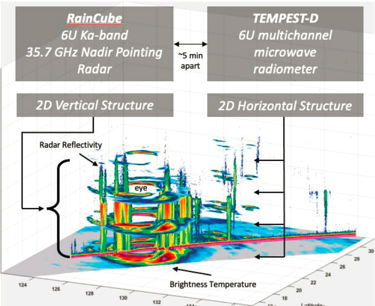
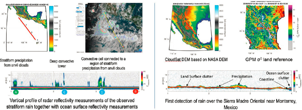
Many success stories exist today in Earth observation where high-quality measurements have been made. For example, the RainCube and Temporal Experiment for Storms and Tropical Systems Demonstration (TEMPEST-D) missions developed a Ka-band (35.75 GHz) precipitation radar and a 5-channel millimeter wave radiometer (89 to 182 GHz) for cloud and precipitation processes, respectively. Although these were both rapidly developed technology flight validation instruments, both missions successfully produced science measurements of high precision and quality from these platforms. They deployed from the International Space Station (ISS) with a separation time allowing for coincident measurements to be performed and to produce new products through data fusion. Figure 4.3 shows one such product from Typhoon Trami on September 28, 2018, where the 165 GHz brightness temperature (horizontal) has been combined with the radar reflectively profile (vertical), producing a three-dimensional (3D) perspective on the typhoon. This is an example of how such methods and techniques, once proven in space, can form the basis for large constellation measurements to address science questions of national priority.
Missions such as TEMPEST-D and RainCube, sponsored by NASA’s Earth Science Technology Office (ESTO), were developed under a program focused on validation of new sensor technologies where investigators worked toward mission requirements that would allow for opportunistic science. The products from such technology demonstration missions need not be limited to science investigations. Commercial organizations are now advancing the deployable radar antenna technology demonstrated on RainCube for future science measurements as well as nonscience applications where radar measurements can be applied to situational awareness, surveillance,
and other areas. The recent selection by NASA of the Investigation of Convective Updrafts (INCUS) as an Earth Venture Mission (EVM-3) is such an example.
Government organizations are also increasingly looking to industry for data-buy opportunities where measurements of commercial interest can be utilized for science applications. NOAA operates a Commercial Weather Data Pilot (CWDP)7 demonstration project tasked with evaluating commercial weather-related data products to assess their quality and potential impact (latency, quality, and reliability) on numerical weather forecast models. As part of this demonstration in September 2021, Spire Global received a contract from NOAA to purchase commercial radio occultation data for satellite weather data delivery. These data will be assimilated into numerical weather prediction models to reduce uncertainties in weather forecasting and will be shared with international meteorological organizations as well as the government.
ENABLING CAPABILITIES OF SMALLSAT CONSTELLATIONS
SmallSats Can Provide High-Quality Science Observations
Educational objectives with the goal of increased access to space drove many of the early CubeSat design approaches in what was originally a bottoms-up development paradigm. The decision to seek standardization had a major positive impact on the growth and success of CubeSats8 with adoption of the concept of the standardized “U” unit of size, the partitioning of satellite sub-systems into U and ½-U stacked volumes resulting in a simple and consistently reproducible configuration. The ubiquity of the 3U CubeSat and the development of standardized PPOD deployment interfaces have been internationally embraced and have played a major role in the popularity of CubeSats as well as being the starting point of what is now called the New Space ecosystem.
Education-oriented missions still exist at universities and have grown significantly in number, but development of CubeSats and SmallSats by the private sector and federal government agencies has fundamentally shifted the focus of the missions and the complexity and quality of the scientific payloads they carry. Complete low-cost spacecraft are now available allowing the focus to be on the science payload. There is also significant payload technology development under way with an emphasis on reduced size, weight, and power without compromising data quality.
This has increased the engagement of segments of the scientific community that previously worked only with large traditional space missions. Two examples of current private-sector SmallSats delivering scientifically valuable measurements are the constellation of GNSS Radio Occultation (GNSS-RO) satellites flown by Spire Global and the X-Band Synthetic Aperture Radar (SAR) satellites flown by Capella Space.9 Spire Global currently has approximately 100 operational CubeSats on-orbit, most carrying GNSS-RO payloads. They produce integrated refractivity and propagation bending angle information from which atmospheric profiles of temperature and humidity can be derived. The quality of the Spire Global GNSS-RO data products has been assessed by the UK Met Office,10 with a finding that their impact on forecast quality is generally comparable to that of GNSS-RO measurements made by larger, traditional spacecraft. As a result, the European Centre for Medium-Range Weather Forecasting (ECMWF) and NASA’s Commercial SmallSat Data Acquisition (CSDA) Program have both initiated data-buys for scientific purposes. In addition, a data quality evaluation effort is under way by NOAA’s CWDP.11 Capella launched its first SmallSat satellite carrying a SAR payload in 2020. It currently has three
___________________
7 “Contract Received by Spire Global from NOAA for Satellite Weather Data Delivery,” Satnews, September 2, 2021, https://news.satnews.com/2021/09/02/contract-received-by-spire-global-from-noaa-for-satellite-weather-data-delivery.
8 Bryce Space and Technology, 2021, SmallSats by the Numbers 2021, BryceTech, Alexandria, VA, https://brycetech.com/reports.
9 See the Capella Space website at http://www.capellaspace.com.
10 N.E. Bowler, 2020, An assessment of GNSS radio occultation data produced by Spire, Quarterly Journal of the Royal Meteorological Society 146:3772–3788, https://doi.org/10.1002/qj.3872.
11 NOAA, 2020, Commercial Weather Data Pilot (CWDP): Round 2 Summary, June, https://www.space.commerce.gov/wp-content/uploads/2020-06-cwdp-round-2-summary.pdf.
operating on-orbit and has plans for more. It has publicly released data that demonstrates well-registered SAR images with ~50 cm spatial resolution.12
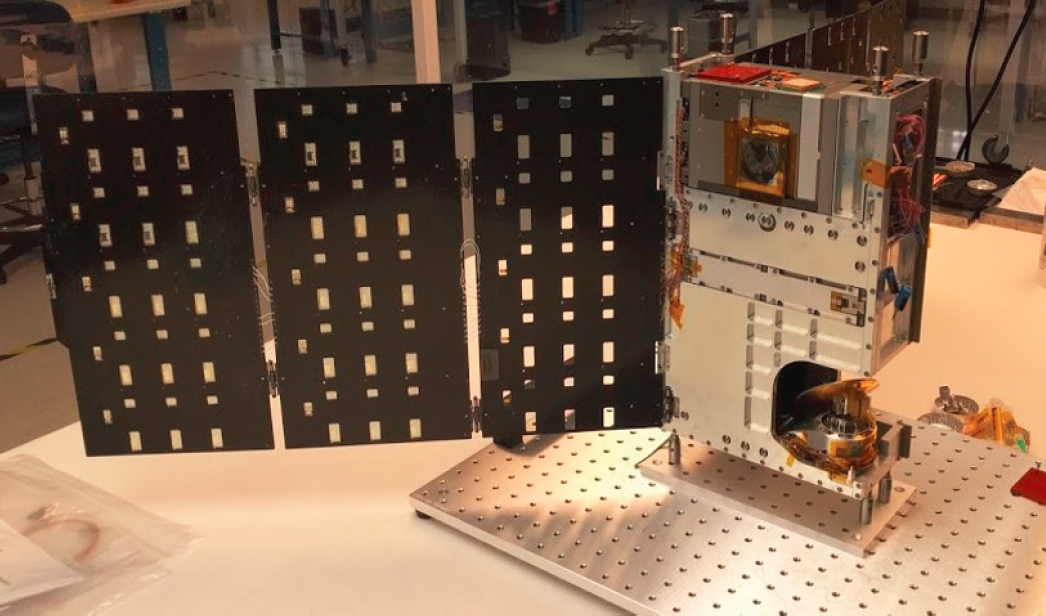
Similar examples of government-funded CubeSats carrying high-quality scientific payloads are the previously mentioned TEMPEST-D (see Figure 4.4) and RainCube instruments. Both were launched in 2018 and have successfully demonstrated the quality and scientific value of their measurements. In the case of TEMPEST-D, scientists from the NASA Precipitation Measurement Mission (PMM) satellite intercalibration team were engaged to perform a similar data quality assessment as they do for large satellites that are part of the PMM constellation. Their results demonstrate comparable data quality for TEMPEST-D with regard to precision, calibration accuracy, and overall uncertainty.13 Both the RainCube and TEMPEST-D science payloads are included in NASA’s recent Earth Venture Mission-3 mission, INCUS, which consists of a constellation of three SmallSats. Notably, INCUS mission execution will be led by an academic institution, Colorado State University.
On a slightly larger scale, the CYGNSS mission is an example of a constellation of eight identical ~25 kg SmallSats in circular LEO orbit.14,15 While government funded, the CYGNSS mission is also led by an academic institution, the University of Michigan, which had full control over all aspects of mission execution both pre- and post-launch. Each spacecraft carries a four-channel bistatic radar receiver tuned to measure GPS navigation
___________________
12 Capella Space, 2020, “Capella Unveils World’s Highest Resolution Commercial SAR Imagery,” December 16, https://www.capellaspace.com/capella-unveils-worlds-highest-resolution-commercial-sar-imagery.
13 W. Berg, S.T. Brown, B.H. Lim, S.C. Reising, Y. Goncharenko, C.D. Kummerow, T.C. Gaier, and S. Padmanabhan, 2021, Calibration and validation of the TEMPEST-D CubeSat radiometer, IEEE Transactions on Geoscience and Remote Sensing 59(6):4904–4914, doi: 10.1109/TGRS.2020.3018999.
14 W. Li, E. Cardellach, F. Fabra, S. Ribó, and A. Rius, 2019, Assessment of spaceborne GNSS-R ocean altimetry performance using CYGNSS mission raw data, Transactions on Geoscience and Remote Sensing 58(1):238–250, doi: 10.1109/TGRS.2019.2936108.
15 In a circular LEO orbit, using a satellite draft CYGNSS does not carry propulsion and maintains the satellite constellation spacing differential drag in the upper atmosphere.
signals scattered back into space from the Earth surface and the constellation has been operating continuously since March 2017.16,17,18 Scattering from the ocean can determine surface wind speed,19 sea level,20 and ocean microplastic concentration.21
With RainCube, its first light measurements of precipitation profiles verified scientific functionality (see Figure 4.5),22 and coincident measurements with TEMPEST-D during simultaneous overpasses of Hurricane Dorian have demonstrated that CubeSats can be viable tools for space-borne meteorology.23
Scattering from land can determine near-surface soil moisture,24 and scattering from inland water bodies allows the water boundaries to be mapped for flood inundation imaging,25 river width and streamflow determination,26
___________________
16 C.S. Ruf, C. Chew, T. Lang, M.G. Morris, K. Nave, A. Ridley, and R. Balasubramaniam, 2018, A new paradigm in Earth environmental monitoring with the CYGNSS small satellite constellation, Scientific Reports 8:8782, doi: 10.1038/s41598-018-27127-4.
17 C.S. Ruf, S. Asharaf, R. Balasubramaniam, S. Gleason, T. Lang, D. McKague, D. Twigg, and D. Waliser, 2019, In-orbit performance of the constellation of CYGNSS hurricane satellites, Bulletin of the American Meteorological Society 100(10):2009–2023, doi: 10.1175/BAMS-D-18-0337.1.
18 W. Li, E. Cardellach, F. Fabra, S. Ribó, and A. Rius, 2019, Assessment of spaceborne GNSS-R ocean altimetry performance using CYGNSS mission raw data, Transactions on Geoscience and Remote Sensing 58(1):238–250, doi: 10.1109/TGRS.2019.2936108.
19 C.S. Ruf, C. Chew, T. Lang, M.G. Morris, K. Nave, A. Ridley, and R. Balasubramaniam, 2019, A new paradigm in earth environmental monitoring with the CYGNSS small satellite constellation, Scientific Reports 8:8782, doi: 10.1038/s41598-018-27127-4.
20 W. Li, E. Cardellach, F. Fabra, S. Ribó, and A. Rius, 2019, Assessment of spaceborne GNSS-R ocean altimetry performance using CYGNSS mission raw data, Transactions on Geoscience and Remote Sensing 58(1):238–250, doi: 10.1109/TGRS.2019.2936108.
21 M.C. Evans and C.S. Ruf, 2021, Towards the detection and imaging of ocean microplastics with a spaceborne radar, Transactions on Geoscience and Remote Sensing 60:1–9 doi: 10.1109/TGRS.2021.3081691.
22 E. Peral, S. Tanelli, S. Statham, S. Joshi, E. Im, T. Imken, D. Price, J. Sauder, N. Chahat, and A. Williams, 2019, “Raincube—A New Paradigm to Observe Weather Processes,” pp. 4978–4981 in IGARSS 2019–2019 IEEE International Geoscience and Remote Sensing Symposium, doi: 10.1109/IGARSS.2019.8898687.
23 G. Stephens, A. Freeman, E. Richard, P. Pilewskie, P. Larkin, C. Chew, S. Tanelli, S. Brown, D. Posselt, and E. Peral, 2020, The emerging technological revolution in Earth observations, Bulletin of the American Meteorological Society 101(3):E274–E285, https://doi.org/10.1175/BAMS-D-19-0146.1.
24 C. Chew and E. Small, 2020, Description of the UCAR/CU soil moisture product, Remote Sensing, 12(10):1558, doi: 10.3390/rs12101558.
25 C. Chew, J.T. Reader, and E. Small, 2018, CYGNSS data map flood inundation during the 2017 Atlantic hurricane season, Scientific Reports 8:9336, https://doi.org/10.1038/s41598-018-27673-x.
26 A. Warnock and C. Ruf, 2019, Response to variations in river flowrate by a spaceborne GNSS-R river width estimator, Remote Sensing 11(20):2450, doi: 10.3390/rs11202450.
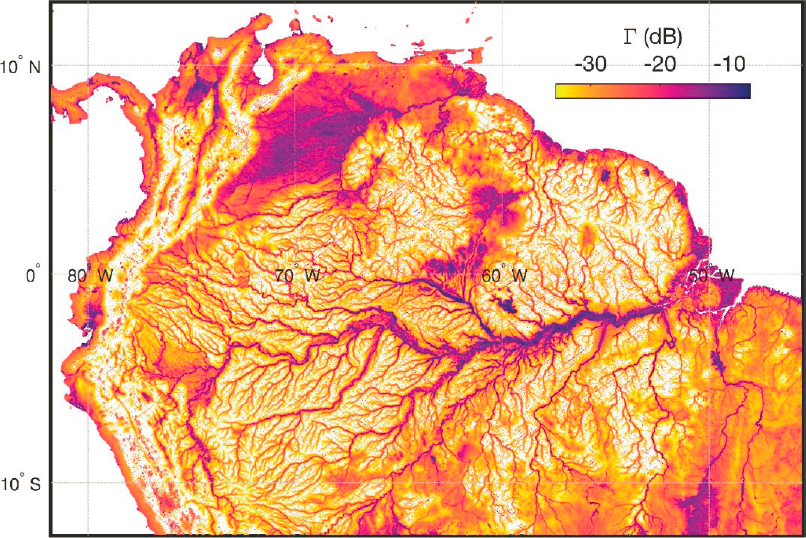
and the generation of wetland water masks under heavy vegetation.27 An example CYGNSS land and inland water body image over the Amazon basin is shown in Figure 4.6.
SMALLSAT TECHNOLOGY APPLIED TO SCIENTIFIC MISSIONS
Earth Science Applications
Oceanography
Oceans cover more than 70 percent of the Earth and have been an important focus of U.S. Navy, NOAA, and NASA, as well as nearly every space agency throughout the world for more than three decades. Numerous missions carrying a broad variety of increasingly sophisticated sensors routinely measure sea surface temperature, sea surface salinity, surface winds and waves, surface currents, sea ice, sea level, and ocean color. These data allow improved knowledge about the role of the oceans on climate; on climate variability (e.g., El Niño-Southern Oscillation [ENSO] events); on climate change (e.g., the oceans store more than 90 percent of the anthropogenic heat accumulated in the climate system28); on the air-sea interactions and their impacts on weather and extreme events; and on short-scale ocean dynamics, marine ecosystems, and so on. Most of these data are assimilated in different kinds of ocean models for improved process understanding, forecasting purposes, and operational oceanography
___________________
27 C. Gerlein-Safdi and C. Ruf, 2019, A CYGNSS-based algorithm for the detection of inland waterbodies, Geophysical Research Letters 46(21):12065–12072, doi: 10.1029/2019GL085134.
28 L. Dahlman and R. Lindsey, 2020, “Climate Change: Ocean Heat Content,” NOAA, August 17, https://www.climate.gov/news-features/understanding-climate/climate-change-ocean-heat-content.
(i.e., estimates of 3D ocean variables for current ocean state, short-range predictions, and ocean re-analyses), benefiting marine industries, service providers, government agencies, as well as the science community.
The majority of the oceanographic missions to date have been medium-to-large platforms with several sensors onboard, such as the altimeter satellites of the Jason series, which carry a radar altimeter plus a radiometer and tracking systems needed for the measuring sea surface height at the required 1 cm accuracy. For certain types of applications, however, SmallSats could satisfy many of the future needs in oceanography.29 To study ocean phenomena, which can spatially and temporally change from hours to weeks/months, SmallSats offer near-real-time coverage of any area of the oceans and can do so with multiple types of platforms. For example, satellites carrying different sensors can provide diverse observations of the same target, of particular relevance to monitoring vulnerable coastal zones changes under natural and anthropogenic forcing.30,31 The wide variety of remote sensing modalities included on the NASA A-Train,32 and the resulting breadth of scientific investigations they were able to support, are an excellent example of this. In addition, constellations of SmallSats in different orbital planes, similar to the GPS constellation, can provide permanent global coverage.
A specific example of a U.S. oceanography community is the NOPP, which represents the ocean interests of 19 government organizations, including the ONR, NOAA, NASA, and USGS.33 NOPP may be a good model of how the science community can operate under the New Space ecosystem. Currently, NOPP can be viewed as a cooperative association of common interests to pool resources and to promote common goals. Under joint ONR and NOAA leadership, NOPP has developed nearly a dozen sophisticated sensors to measure coastal ocean parameters. These sensors will collect data to initialize prediction models and to support Navy operations. However, good science practice requires a test and evaluation process before those sensors can be fielded as part of an operational system. The advent of commercial organizations that have the capacity to offer affordable, precise, and repeatable testing is emerging as a means to reliably support such services at large scale for the SmallSat instrument community.
Hydrology
For more than two decades, the hydrological science community has been using data provided by space-borne sensors. Combined with hydrological modeling or used in isolation, they offer an alternative to the ground-based observations. This is especially valuable for developing nations where in situ networks are declining or are even nonexistent (e.g., in Africa). Different space-based observing systems have allowed measurements of the parameters of the terrestrial water balance, either directly (e.g., precipitation and water storage change) or indirectly (e.g., evapotranspiration and river runoff). Some traditional larger missions have been specifically designed for measuring these parameters (e.g., Tropical Rainfall Measuring Mission [TRMM] and Global Precipitation Measurement [GPM] for precipitation and Gravity Recovery and Climate Experiment [GRACE/GRACE-Follow On] for water storage change). It is also the case for soil moisture, another important hydrological parameter (e.g., Soil Moisture Active Passive [SMAP] and Soil Moisture and Ocean Salinity [SMOS] missions). More recently, the CYGNSS constellation of SmallSats has also been shown able to measure soil moisture.34 The more frequent, sub-daily,
___________________
29 A.G.C. Guerra, F. Francisco, J. Villate, F.A. Angelet, O. Bertolami, and K. Rajan, 2016, On small satellites for oceanography: A survey, Acta Astronautica 127:404–423, https://doi.org/10.1016/j.actaastro.2016.06.007.
30 J. Benveniste, A. Cazenave, S. Vignudelli, L. Fenoglio-Marc, R. Shah, R. Almar, O. Andersen, et al., 2019, Requirements for a coastal hazard observing system, Frontiers in Marine Science 6:348, doi: 10.3389/fmars.2019.00348.
31 R. Ponte, M. Carson, M. Cirano, C.M. Domingues, S. Jevrejeva, M. Marcos, G. Mitchum, et al., 2019, Towards comprehensive observing and modeling systems for monitoring and predicting regional to coastal sea level, Frontiers in Marine Science 6:437, doi: 10.3389/fmars.2019.00437.
32 NASA, “The Afternoon Constellation,” https://atrain.nasa.gov.
33 See National Oceanographic Partnership Program—Promoting Partnerships for the Future of the Ocean, Coasts and Great Lakes, https://www.nopp.org.
34 H.V. Kim and V. Lakshmi, 2018, Use of Cyclone Global Navigation Satellite System (CyGNSS) observations for estimation of soil moisture, Geophysical Research Letters 45(16):8272–8282, doi: 10.1029/2018GL078923; C. Chew and E. Small, 2020, Description of the UCAR/CU soil moisture product, Remote Sensing 12(10):1558, doi: 10.3390/rs12101558.
revisit time provided by the constellation has been shown to improve upon the multi-day temporal sampling by a single satellite when assimilated into a land surface model.35
Evapotranspiration is not observed directly but is derived from different remote sensing techniques, in combination with modeling. This is also the case for river runoff. High-precision radar and laser satellite altimetry developed in the early 1990 to study ocean dynamics and climate-related sea level is now routinely used to monitor lakes and large river-level changes. River runoff can be derived from space-based river elevation via modeling approaches and/or calibration with in situ data but the coarse resolution of space observations greatly limits this application to large river systems. Moreover, the revisit time of current altimetry missions, of at best 10 days for the Jason mission series, does not match the desired daily or sub-daily temporal resolution required for river discharge estimates used for water resource management and flood forecasting.36 One way of increasing this revisit time can be achieved by launching SmallSat constellations. For example, a constellation of 10 SmallSats in the same orbital plane of a 10-day repeat orbit would allow a daily revisit time of a large number of rivers on Earth and a data latency of a few hours as needed for water resource management and water-related disasters forecasting. Such SmallSat constellations distributed through different orbital planes would also increase the spatial coverage toward a larger number of river systems and offer an invaluable complement to the upcoming wide-swath altimetry Surface Water and Ocean Topography (SWOT) mission (launch in 2022).
Atmosphere
Measurements of the atmosphere from space have, for decades, played a central role in the study of atmospheric physical processes, the detection of atmospheric gaseous and particulate composition, and the monitoring of upwelling radiant energy spectra. Measurements of atmospheric profiles of temperature, humidity, liquid and ice clouds and precipitation, and of latent and sensible heat fluxes at the surface are regularly used operationally for numerical weather forecasting. Long-term measurements of many atmospheric state variables play a central role in the detection, characterization, and prediction of global and regional climate change. Observations of most of these atmospheric variables have been demonstrated by CubeSat and SmallSat payloads. Most mature among them are measurements made of atmospheric temperature and humidity profiles by constellations of GNSS-RO sensors.37 Measurements of wind speed and of latent and sensible heat flux at the ocean surface have been made by constellations of GNSS-R sensors.38 More recent measurements have been made by the TEMPEST-D millimeter-wave spectrometer/imagers, the RainCube precipitation radar, and the Radiometer Assessment Using Vertically Aligned Nanotubes (RAVAN) Earth radiance radiometer. Large N constellations of these SmallSat atmospheric sensors will significantly reduce the revisit time of global observations. This will provide improved initialization of numerical weather forecasts in support of scientific studies and will also allow short-term extreme weather events to be better tracked and imaged in support of situational awareness for disaster management.
Monitoring and Providing Operational Support for Natural and Human-Made Disasters
SmallSat constellations dedicated to surveying major disasters would be a ground-breaking application of this new technology, in ways that can serve Earth observation needs with extremely high societal relevance. For about
___________________
35 H. Kim, V. Lakshmi, Y. Kwon, and S.V. Kumar, 2021, First attempt of global-scale assimilation of subdaily scale soil moisture estimates from CYGNSS and SMAP into a land surface model, Environmental Research Letters 16(2021):074041, doi: 10.1088/1748-9326/ac0ddf.
36 M.F. McCabe, M. Rodell, D.E. Alsdorf, D.G. Miralles, R. Uijlenhoet, W. Wagner, A. Lucieer, et al., 2017, The future of Earth observation in hydrology, Hydrology and Earth System Sciences 21:3879–3914, doi: 10.5194/hess-21-3879-2017.
37 N.E. Bowler, 2020, An assessment of GNSS radio occultation data produced by Spire, Quarterly Journal of the Royal Meteorological Society 146(733):3772–3788, doi: 10.1002/qj.3872.
38 C. Ruf, S. Gleason, and D.S. McKague, 2018, Assessment of CYGNSS wind speed retrieval uncertainty, IEEE Journal of Selected Topics in Applied Earth Observations and Remote Sensing 12(1):87–97, doi: 10.1109/JSTARS.2018.2825948; J.A. Crespo, D.J. Posselt, and S. Asharaf, 2019, CYGNSS surface heat flux product development, Remote Sensing 11(19):2294, doi: 10.3390/rs11192294; Z. Cui, Z. Pu, V. Tallapragada, R. Atlas, and C.S. Ruf, 2019, A preliminary impact study of CYGNSS ocean surface wind speeds on numerical simulations of hurricanes, Geophysical Research Letters 46(5):2984–2992, doi: 10.1029/2019GL082236.
two decades, space agencies and space system operators have implemented the International Disaster Charter39 to provide high-resolution satellite imagery to civil security organizations and the United Nations to facilitate the implementation of field operations. As soon as a major disaster occurs anywhere on Earth, the charter is activated. It consists of programming the acquisition of optical or radar images of the disaster area using all available in-orbit satellites. The detailed mapping of the impacted area and survivors’ identification is crucial for rapid and efficient field rescue.
Natural hazards “such as earthquakes, volcanic eruptions, tsunamis, wildfires, and hydro-meteorological extremes (e.g., cyclones, floods, storm surges, landslides triggered by heavy rainfall or floods, heat waves, and droughts),” as well as human-made hazards (e.g., air and sea pollution) have strong negative effects on the environment and human societies. Hydro-meteorological hazards are the most frequent disasters and are intensifying with time as a result of climate change and related global warming. Satellite observations are “increasingly used to support disaster monitoring, mitigation, adaptation, and risk management. The space-based observing systems have several advantages compared to in situ networks. Since they are not affected by the hazards occurring at the surface of the Earth,” space-based observing systems provide important advantages compared to in situ networks. They collect consistent data over different spatial and temporal scales and provide important information on dangerous and/or remote areas. The satellite observations provide a synoptic view of natural hazards, allowing improved understanding of the underlying processes and their complex interactions, as well as of their associated risks.40
BENEFITING FROM INTERNATIONAL OPPORTUNITIES
The New Space ecosystem can be considered to have worldwide impact. Of the 2,972 SmallSats operated worldwide from 2011 to 2020, U.S. operators, including SpaceX, have led the way with 68 percent of these missions. The next largest single operator of SmallSats is China at 8 percent, followed by the United Kingdom, Japan, Russia, and Germany with percentages ranging from 2 to 4 percent.
As part of its future Earth observation program, the European Space Agency (ESA) has recently developed a new initiative called “Scout,” consisting of SmallSats that add scientific value to data from current larger missions of the ESA Earth Explorer program and the Copernicus Sentinel missions.41 The objective is to demonstrate the capability of SmallSats to deliver value-added science, either by miniaturization of existing technologies or by developing new sensing techniques. The Scout missions consist of several small spacecraft orbiting in constellation, and developed within 3 years (from kick-off to launch) for a maximum cost of 30 million euros (budget including space and ground segments, launch, and in-orbit commissioning). Four mission concepts are currently under the studies Earth System Processes Monitored in the Atmosphere by a Constellation of CubeSats42 (ESP-MACCS) for measuring upper troposphere composition and aerosols; Hydrological Global Navigation Satellite System (HydroGNSS) dedicated to soil moisture, freeze/thaw cycle of permafrost, wetlands inundations, and biomass; Twin Anthropogenic Greenhouse Gas Observers (TANGO) for monitoring methane and other greenhouse gas-emissions; and NanoMagSAT for measuring the Earth magnetic field and ionospheric environment.
The distribution of SmallSat launches across nations from 2011 to 2021 is examined in BryceTech (2021).43 While the United States, Russia, India, and China have accounted for the large majority of launches worldwide throughout the decade, several trends are noteworthy. The percentage of launches in the United States has grown significantly, due primarily to the increasing number of commercial Starlink and OneWeb launches. In addition, over the past decade the percentage of Russian launches has generally decreased, while the percentage of Indian and Chinese launches has increased. The Japan Aerospace Exploration Agency (JAXA) space agency and Japanese
___________________
39 See the International Charter Space and Major Disasters website at https://disasterscharter.org.
40 Excerpts of this paragraph are taken from Guest Editorial: International Space Science Institute (ISSI) Workshop on Geohazards and Risks Studied from Earth Observations, https://link.springer.com/article/10.1007/s10712-020-09617-1.
41 European Space Agency, “Earth Observing Missions: Mission Navigator,” https://www.esa.int/Applications/Observing_the_Earth/Earth_observing_missions.
42 European Space Agency, 2020, “ESP-MACCS,” November 26, https://www.esa.int/ESA_Multimedia/Images/2020/11/ESP-MACCS.
43 Bryce Space and Technology, 2021, SmallSats by the Numbers 2021, BryceTech, Alexandria, VA, https://brycetech.com/reports.
universities also develop technological demonstration satellites for both industry applications and natural disaster monitoring.
Evolving the Space Science Paradigm
Considering space science in the broadest sense as a source of data and information leading to knowledge, the goals of both traditional and nontraditional science programs are fundamentally aligned to the information-driven goals of HSA. This alignment bodes well for science benefiting from a partnership within the HSA New Space operational framework. Chapter 5 will discuss options for how science users can best benefit from this partnership when considering the early current state of the ecosystem and then the maturing state as it evolves and grows and changes in response to government needs in combination with business pressures.
No matter how good this initial alignment seems, HSA will be the dominant government driver of the ecosystem. Science users will need to be creative, agile, and adaptive to the government–business partnership as it constantly adapts its contracting approach evolve over time to what will be divergent and convergent pressures driven by the HSA needs of the primary government users. Most of the infrastructure capabilities and processes required to sustain high-quality SmallSat constellation science measurements such as onboard processing capability, ground operational support, cybersecurity, supply chain security, safety and mission assurance, and interoperability standards will run in parallel with those of HSA (see Chapter 3).
Some required capabilities are unique to science measurements and will almost certainly evolve as the ecosystem grows and as the performance expectations become more demanding and specific. In particular, the introduction of methods allowing data to be shared openly with the international community will grow in importance as a means to manage the increasing number of on-orbit systems. In this regard, policies with associated agreements (both business and political) supporting international collaborations will be required when considering the potential to sustain flight measurements over a period of decades without loss of continuity in the data record.
There are also some measurements that are better suited for, if not only possible by, traditional large satellites that may not align perfectly with HSA. One such class of measurements is those at sufficiently long electromagnetic wavelengths for which diffraction-limited optics define the spatial resolution. Passive microwave radiometers and incoherent scatterometer radars are two examples. In such cases, very large apertures are required to provide adequate spatial resolution, and larger satellites can more readily accommodate them. There is significant technology development under way in the area of High Compaction Ratio (Mission Volume/Launch Volume) technology, especially in ultra-compact, deployable antennas, so this may become less of a limitation over time. A second class of measurements better suited to large satellites are those involving many different types of sensors observing the same volume of the atmosphere or area of the surface at the same time. Multi-frequency, multi-polarization, multilook angle, active/passive, or other types of simultaneous measurements are extremely useful for constraining the allowable states of the observed body and for supporting fundamental process studies in Earth system science.
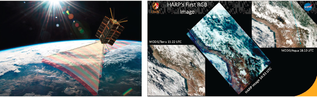
Yet even in this context, technology advancements continue in ways that science-related business contracts will need to recognize and adapt. The Hyper-Angular Rainbow Polarimeter (HARP) CubeSat technology demonstration mission, sponsored by NASA ESTO, performed the first hyperangular cloudbow retrieval from space. HARP demonstrated the ability to characterize aerosol particles and measure “properties of cloud particles including their thermodynamic phase (ice or water) and the size of cloud water droplets.”44 This polarimeter instrument measures more than 120 unique viewing angles simultaneously through four visible wavelengths and three unique polarization states and represents a prototype for future designs that will be supported on larger spacecraft platforms (see Figure 4.7).
A multi-sensor platform necessarily requires more size, weight, power, and data rate accommodation, making a larger satellite bus necessary. One attractive side benefit of the miniaturization of SmallSat sensors is that the required size of a “large” satellite capable of supporting many sensors has decreased significantly. Indeed, this strategy is being considered for future polarimeter SmallSat constellation designs that may carry multiple HARP-like instruments on a single, albeit smaller, spacecraft platform.
___________________
44 University of Maryland, Baltimore County, “HARP Overview,” https://userpages.umbc.edu/~martins/laco/harp.htm.
For some applications (e.g., measurement of sea level change at an accuracy of 0.5 mm/year or better), it is very challenging to use SmallSats. On the other hand, the use of SmallSats to measure some ocean variables is a real advantage (e.g., short-term forecasting via data assimilation in ocean models). Therefore, combining larger dedicated missions with SmallSat constellations is likely to be the optimal strategy to monitor the full range of processes occurring in the ocean.
To summarize, in view of their shorter development phase, lower cost, increased temporal resolution, and other benefits, SmallSats are of growing relevance in various fields of the Earth sciences. However, they would not entirely replace larger missions owing to the inherent technical limitations that have been discussed. Thus, they need to be used for specific science applications, in complement with larger dedicated missions, or under conditions where they provide a unique measurement capability that a single large platform cannot perform. Fortunately, the business approaches discussed in Chapter 5 are amenable to supporting the HSA goals and can also be adapted in ways that can support both the HSA and science users.
CONCLUSIONS AND RECOMMENDATIONS
CONCLUSION: SmallSats are demonstrating their utility in national civil missions with respect to oceanography, meteorology, hydrology, disaster assessment, and other applications associated with the Earth sciences. When applicable, they complement traditional systems in the Hybrid Space Architecture by offering increased temporal and spatial resolution and reduced planning cycles, which permit rapid insertion of new technology over traditional approaches. It is expected that SmallSat technology and sensor capabilities, as well as related services, will expand in the future.
RECOMMENDATION: The U.S. government should actively position itself to take full advantage of the evolving and growing capabilities of the commercial space sector to serve the broadest spectrum of traditional and nontraditional users, with applications to oceanographic and coastal data as an initial effort to experiment with new process and procedures.
CONCLUSION: SmallSat mission partnerships between the U.S. government and academic institutions have produced high-value/low-cost advancements in space science and technology, including satellite platforms and payloads, ground segment communications, mission and payload operations, and science data product generation and distribution.
RECOMMENDATION: As part of its ongoing relationship with academic institutions the Office of Naval Research should examine emerging advanced sensor and associated technology opportunities that benefit future ocean science objectives and missions.45
___________________
45 This recommendation was edited after release to the sponsor to delete reference to the National Oceanographic Partnership Program. This clarifies that the committee is recommending that ONR take this step in support of its own objectives and missions.


