


Below is the uncorrected machine-read text of this chapter, intended to provide our own search engines and external engines with highly rich, chapter-representative searchable text of each book. Because it is UNCORRECTED material, please consider the following text as a useful but insufficient proxy for the authoritative book pages.
24 Chapter 3. Research Approach Introduction This chapter documents the approach used to investigate three aspects of pedestrian QOS: ï· Pedestrian satisfaction crossing roadways, with and without the presence of selected pedestrian safety countermeasures; ï· Updating the HCM 6th Edition pedestrian delay estimation methods for signalized and unsignalized crossings; and ï· Investigating methods for evaluating pedestrian network QOS. Chapter 4 presents the results of each of these investigations. Pedestrian Crossing Satisfaction and Safety Countermeasures A three-pronged approach was used to investigate pedestrian satisfaction crossing roadways with and without the presence of selected pedestrian safety countermeasures: ï· Intercept surveys were conducted at study intersections in Chapel Hill, NC, and Portland, OR, to ask pedestrians about their satisfaction crossing the street. Video observations were made simultaneously so that the responses could be compared to the actual conditions experienced by the pedestrians during their crossing. ï· Longer video observations were made at the same study intersections used for the intercept surveys, but on other days, to compare differences in pedestrian and motorist behavior between the treated and untreated sites. ï· A naturalistic walking study was conducted, in which recruited volunteers in Chapel Hill, NC wore biosensing wristbands and carried devices recording their location as they made their normal walking trips over the course of the week, which included passing through some of the crossings where intercept surveys and video observations were made. Intercept Surveys This section documents the approach to the pedestrian intercept surveys. The intercept survey instrument and survey protocol were piloted in Task 6B and adjusted as necessary before commencing data collection as part of Task 6D. Attachment C1 in Appendix C provides the survey instrument and details about the survey protocol. Site Selection The research team collected data at 60 locations (30 treated and 30 similar untreated sites as control sites, divided into marked crosswalks and unmarked crosswalks, with similar traffic volumes, speeds, and lane configurations to the extent possible). The team identified ten known instances of each study treatment type (RRFB, Median Island, and LPI) in each city (Chapel Hill and Portland), and collected a range of information about each location, including posted speed limit, one-way or two-way traffic directionality, number of through lanes, presence of a center turn lane, and nearest available traffic volume (AADT) count for the primary road. In addition, the presence of nearby bus stops and schools were noted.
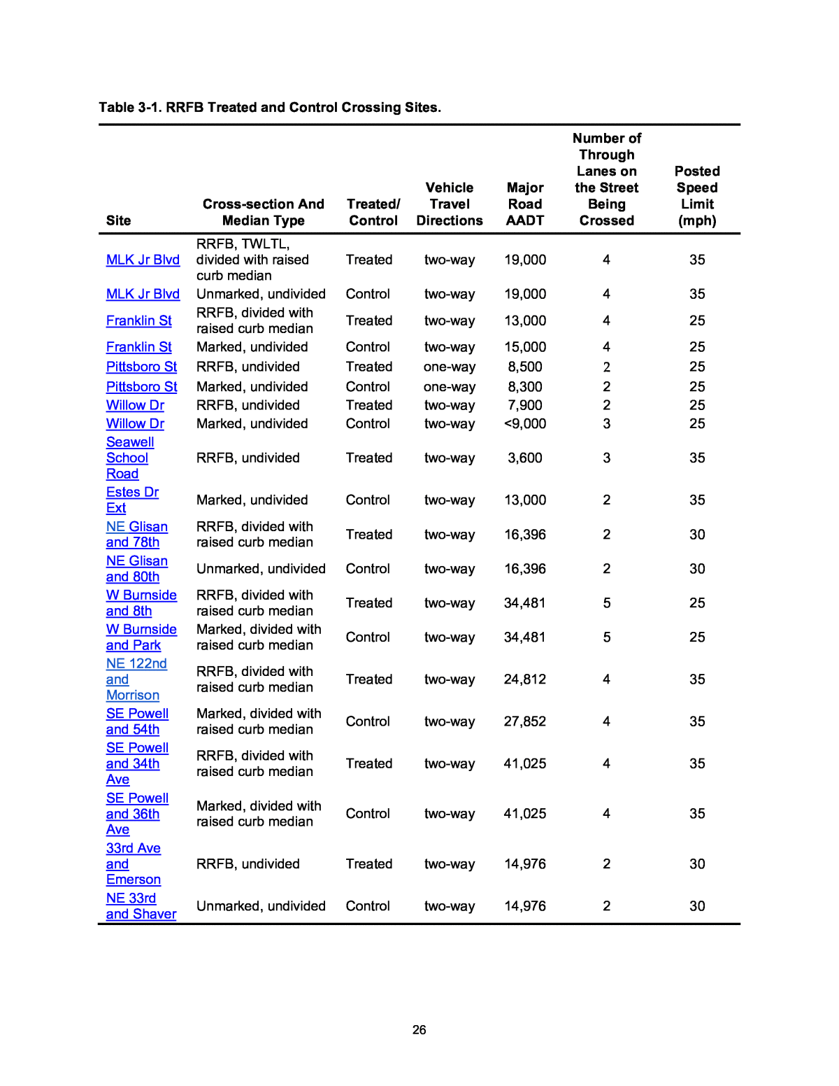
25 Next, working from the identified treated locations, the team selected ten locations for each treatment type, seeking to represent a spectrum of road and traffic conditions. The team aimed to have a mix of two- to three-lane crossings and four- to five-lane crossings for the unsignalized sites (i.e., RRFB and control sites, Median Island and control sites). Within those groupings, the team sought a range of AADTs and traffic speeds. Other selection criteria included the avoidance of locations near primary or secondary schools, as only those 18 years or older could be interviewed per IRB requirements, as well as avoiding locations primarily serving joggers or bicyclists, as the study focus was on utilitarian walking. Finally, the team considered the anticipated pedestrian volumes, and prioritized sites where higher volumes were expected. Due to large gaps in pedestrian counts at most locations, the expected pedestrian volume was based primarily on the research teamâs knowledge of the site locations. In some cases, the team struggled to find unmarked and marked control crosswalks with sufficient pedestrian traffic to study. To the extent feasible, each treated site was matched with a similar control site according to both groupsâ vehicle travel directions (one-way vs. two-way), AADT, number of through lanes, and posted speed limit. The team prioritized some treated sites because there were ideal control sites that existed for them. In many cases, control locations were on the same or adjacent routes, which helped minimize potential confounding factors between treatment and control locations. Tables 3-1 through 3-3 show the characteristics of the treatment and control sites selected in Portland and Chapel Hill by treatment type.
26 Table 3-1. RRFB Treated and Control Crossing Sites. Site Cross-section And Median Type Treated/ Control Vehicle Travel Directions Major Road AADT Number of Through Lanes on the Street Being Crossed Posted Speed Limit (mph) MLK Jr Blvd RRFB, TWLTL, divided with raised curb median Treated two-way 19,000 4 35 MLK Jr Blvd Unmarked, undivided Control two-way 19,000 4 35 Franklin St RRFB, divided with raised curb median Treated two-way 13,000 4 25 Franklin St Marked, undivided Control two-way 15,000 4 25 Pittsboro St RRFB, undivided Treated one-way 8,500 2 25 Pittsboro St Marked, undivided Control one-way 8,300 2 25 Willow Dr RRFB, undivided Treated two-way 7,900 2 25 Willow Dr Marked, undivided Control two-way <9,000 3 25 Seawell School Road RRFB, undivided Treated two-way 3,600 3 35 Estes Dr Ext Marked, undivided Control two-way 13,000 2 35 NE Glisan and 78th RRFB, divided with raised curb median Treated two-way 16,396 2 30 NE Glisan and 80th Unmarked, undivided Control two-way 16,396 2 30 W Burnside and 8th RRFB, divided with raised curb median Treated two-way 34,481 5 25 W Burnside and Park Marked, divided with raised curb median Control two-way 34,481 5 25 NE 122nd and Morrison RRFB, divided with raised curb median Treated two-way 24,812 4 35 SE Powell and 54th Marked, divided with raised curb median Control two-way 27,852 4 35 SE Powell and 34th Ave RRFB, divided with raised curb median Treated two-way 41,025 4 35 SE Powell and 36th Ave Marked, divided with raised curb median Control two-way 41,025 4 35 33rd Ave and Emerson RRFB, undivided Treated two-way 14,976 2 30 NE 33rd and Shaver Unmarked, undivided Control two-way 14,976 2 30
27 Table 3-2. Median Island Treated and Control Crossing Sites. Site Cross-section And Median Type Treated/ Control Vehicle Travel Directions Major Road AADT Number of Through Lanes on the Street Being Crossed Posted Speed Limit (mph) South Rd Marked, divided with raised curb median Treated two-way 7,400 2 25 South Rd Unmarked, undivided Control two-way 7,400 2 25 Columbia St Marked, divided raised median island Treated two-way 14,000 2 35 Columbia St Unmarked, undivided Control two-way 14,000 2 35 Weaver Dairy Rd Marked, divided with raised curb median Treated two-way 13,000 4 35 NC-54 Unmarked Control two-way 33,000 4 45 E Burnside and 22nd Marked, divided with raised curb median Treated two-way 17,359 3 30 E Burnside and 26th Marked, undivided Control two-way 17,359 3 30 SE Hawthorne and 43rd Marked, divided with raised curb median Treated two-way 14,542 2 20 SE Hawthorne and 46th Unmarked, undivided Control two-way 14,542 2 20 NE MLK at Jarrett Marked, divided with raised cub median Treated two-way 27,134 4 30 NE MLK at Graham Marked undivided Control two-way 29,698 4 30 SE Stark and 86th Marked, divided wit raised curb median Treated one-way 13,485 2 30 SE Stark and 80th Marked, undivided Control one-way 10,600 2 20 SW Vermont and Idaho Marked, divided with raised curb median Treated two-way 9,363 2 35 SW Vermont and 37th Marked, undivided Control two-way 9,363 2 35 NE Sandy and 36th Marked, divided with raised curb median Treated two-way 25,121 4 30 NE Sandy and 17th Unmarked, undivided Control two-way 25,121 4 30 NE MLK at Cook Marked, divided with raised curb median Treated two-way 29,698 4 30 NE MLK and Sumner Marked, undivided Control two-way 29,698 4 30
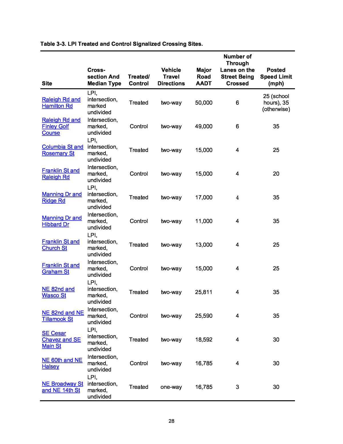
28 Table 3-3. LPI Treated and Control Signalized Crossing Sites. Site Cross- section And Median Type Treated/ Control Vehicle Travel Directions Major Road AADT Number of Through Lanes on the Street Being Crossed Posted Speed Limit (mph) Raleigh Rd and Hamilton Rd LPI, intersection, marked undivided Treated two-way 50,000 6 25 (school hours), 35 (otherwise) Raleigh Rd and Finley Golf Course Intersection, marked, undivided Control two-way 49,000 6 35 Columbia St and Rosemary St LPI, intersection, marked, undivided Treated two-way 15,000 4 25 Franklin St and Raleigh Rd Intersection, marked, undivided Control two-way 15,000 4 20 Manning Dr and Ridge Rd LPI, intersection, marked, undivided Treated two-way 17,000 4 35 Manning Dr and Hibbard Dr Intersection, marked, undivided Control two-way 11,000 4 35 Franklin St and Church St LPI, intersection, marked, undivided Treated two-way 13,000 4 25 Franklin St and Graham St Intersection, marked, undivided Control two-way 15,000 4 25 NE 82nd and Wasco St LPI, intersection, marked, undivided Treated two-way 25,811 4 35 NE 82nd and NE Tillamook St Intersection, marked, undivided Control two-way 25,590 4 35 SE Cesar Chavez and SE Main St LPI, intersection, marked, undivided Treated two-way 18,592 4 30 NE 60th and NE Halsey Intersection, marked, undivided Control two-way 16,785 4 30 NE Broadway St and NE 14th St LPI, intersection, marked, undivided Treated one-way 16,785 3 30
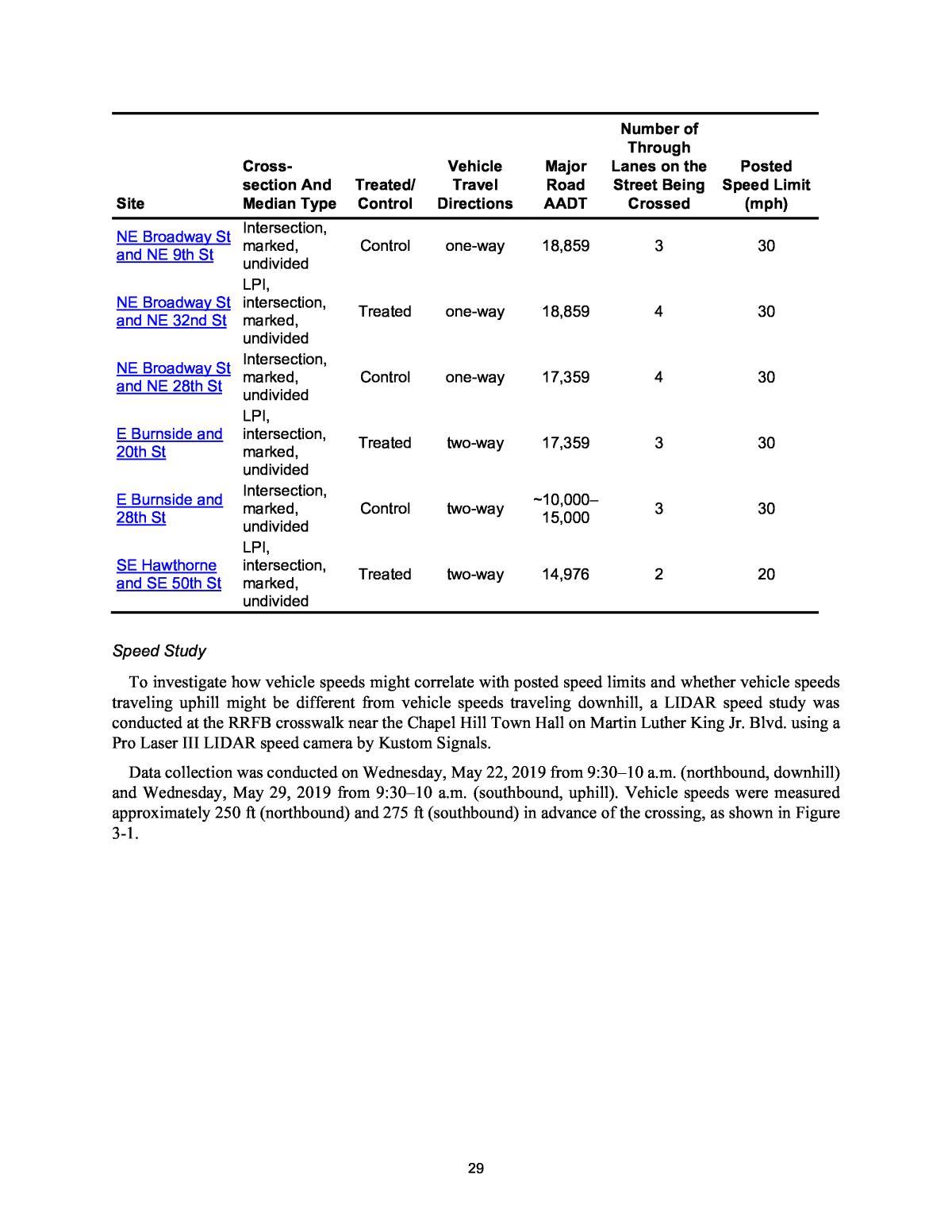
29 Site Cross- section And Median Type Treated/ Control Vehicle Travel Directions Major Road AADT Number of Through Lanes on the Street Being Crossed Posted Speed Limit (mph) NE Broadway St and NE 9th St Intersection, marked, undivided Control one-way 18,859 3 30 NE Broadway St and NE 32nd St LPI, intersection, marked, undivided Treated one-way 18,859 4 30 NE Broadway St and NE 28th St Intersection, marked, undivided Control one-way 17,359 4 30 E Burnside and 20th St LPI, intersection, marked, undivided Treated two-way 17,359 3 30 E Burnside and 28th St Intersection, marked, undivided Control two-way ~10,000â15,000 3 30 SE Hawthorne and SE 50th St LPI, intersection, marked, undivided Treated two-way 14,976 2 20 Speed Study To investigate how vehicle speeds might correlate with posted speed limits and whether vehicle speeds traveling uphill might be different from vehicle speeds traveling downhill, a LIDAR speed study was conducted at the RRFB crosswalk near the Chapel Hill Town Hall on Martin Luther King Jr. Blvd. using a Pro Laser III LIDAR speed camera by Kustom Signals. Data collection was conducted on Wednesday, May 22, 2019 from 9:30â10 a.m. (northbound, downhill) and Wednesday, May 29, 2019 from 9:30â10 a.m. (southbound, uphill). Vehicle speeds were measured approximately 250 ft (northbound) and 275 ft (southbound) in advance of the crossing, as shown in Figure 3-1.
30 Base image source: © 2019 Google Figure 3-1. Distance Measurements for LIDAR Speed Gun Data Collection. Travel speeds were measured for 100 vehicles in each travel direction. Speeds were not collected during the same time period of the intercept survey data collection for this crossing (Tuesday, March 19, 2019, 12:00â2:00 p.m.) due to scheduling constraints. Speeds were collected when (1) no pedestrians were crossing or waiting to cross, (2) the beacon was not flashing, and (3) no cars were slowing down to turn. In addition, speeds were collected only when a vehicle was traveling unaccompanied by others (within 5 seconds), so that each motorist could be deemed to be selecting his or her own speed. Table 3-4 and Figure 3-2 display the results of the speed study. The posted speed limit at this crossing is 35 mph. Table 3-4. Results of Speed Investigation along MLK Jr. Blvd. in Chapel Hill. Attributes Northbound Southbound Minimum speed (mph) 23 23 Maximum speed (mph) 49 44 Number of vehicles recorded 100 100 Standard deviation (mph) 4.25 3.79 Average speed (mph) 34.4 36.4 85th percentile speed (mph) 38.9 40.0 % of cars above 35-mph speed limit 40% 61%
31 Figure 3-2. Histogram of Motorist Speeds at RRFB Crossing of Martin Luther King Jr. Blvd. near Chapel Hill Town Hall. The team considered a variety of factors when analyzing data and drawing conclusions. Motorists traveling northbound (downhill) had just traveled through a horizontal curve as well as a transition from a 25- to a 35-mph speed limit. Southbound (uphill) motorists experienced a consistent 35-mph section of roadway before entering an urban environment with a speed limit of 25 mph. The data supported the hypothesis that motoristsâ average speed is roughly consistent with the posted speed limit. However, the data did not support the hypothesis that motoristsâ speed is grade-dependent. The downgrade seemed to have affected some driversâ travel speed, often at the higher end of the speed distribution, yet fewer drivers sped when traveling in the northbound (downhill) direction. Because of these results (i.e., lack of support for grade-dependent speed and support for motoristsâ speed being related to posted speed), the team chose not to conduct speed studies at the other sites. That said, with only one site studied, behavior may differ elsewhere, and conclusions may not be applicable at other sites. Intercept Survey Content The research team developed intercept surveys to assess pedestrian satisfaction with the crossings. The team administered these surveys for approximately two hours at each location or until a minimum number of 10 surveys per site was gathered. Surveys were typically administered on a Tuesday, Wednesday, or Thursday from either 12:00â2:00 p.m. or 4:00â6:00 p.m., depending on the expected peak period of pedestrian traffic. For sites where weekend peaks were expected, intercept surveys were administered on a Saturday from 12:00â2:00 p.m. Survey responses were collected on iPads using the Qualtrics survey software. The survey began with a consent form and asked for respondentsâ agreement to participate in the study. To gauge pedestrian satisfaction, the first question asked for the respondent to rate their crossing experience using a 4-point Likert scale of agreement. The survey asked about the pedestrianâs walking trip purpose, length, and potential connection to public transportation. The survey also presented statements that the pedestrians were asked to indicate their level of agreement with, such as âI felt rushed trying to cross this street.â Respondents finished the survey by providing their ethnicity and age. The surveyor then recorded respondentsâ crossing behaviors to contextualize their responses. Behaviors of interest included whether
32 pedestrians actuated the RRFB push-button, the degree to which they appeared distracted, and their apparent gender and group size. The full pedestrian crossing survey is provided in Appendix C. How Were Surveyors Positioned? Each site required two surveyors to intercept pedestrians crossing in either direction. At RRFB, marked crossing, median crossing, LPI, and LPI control sites, surveyors stood on opposite sides of the street, close to the entrances to the crosswalks. For unmarked crossings, surveyors stood on the sidewalks close to crossing pedestrians. Surveyors ensured their positioning did not interfere with pedestriansâ crossing maneuvers. How Did Surveyorsâ Approach Potential Respondents? To solicit survey responses, surveyors approached pedestrians after they had used the crosswalk. Examples of approaches include: âHi there! Do you have a minute to take a survey on crossing the street here?â and âHey there! Do you have some time to answer questions about this crosswalk?â After verbally agreeing, the pedestrian was handed the iPad to complete the survey. The surveyor then recorded certain behaviors of the respondentâs crossing to contextualize the response. Surveyors attempted to diversify the sample population and avoided consistently choosing the first person who crossed the street. Surveyors took note of any refusals. Surveyors did not ask for responses from pedestrians who appeared to be under 18, nor from those who were jogging or bicycling. Video Collection and Reduction Surveyors collected video during the intercept survey administration, using one or two cameras provided installed by the project team. Some pedestrian behaviors were coded in the field; the video allowed the survey team to confirm the coded behaviors and to observe additional behaviors that were difficult to record in the field, such as whether the pedestrian looked for traffic before crossing. Each intercept survey respondent was identified in the video to further study driver and pedestrian behavioral characteristics while crossing. The video was matched with the survey responses to further code the pedestrianâs behavior and the crossing environment. For unsignalized crosswalks and their respective controls, the following were coded: signal compliance, pedestrian delay, looking at traffic before crossing, gaze while crossing, perceived speed, crosswalk compliance, interactions with motorists and cyclists, group size, group type, and gender. For signalized crosswalks and respective controls: push-button activation; signal compliance with the pedestrian signal, LPI, and traffic signal; pedestrian delay, looking at traffic before crossing, gaze while crossing, perceived speed, crosswalk compliance, interaction with motorists and cyclists, group size, group type, and gender. Coders also counted four motor vehicle maneuvers: right turn from major, right turn from minor, through movement from minor, and left turn from minor (Figure C1-1 in Appendix C1). The Chapel Hill team used a Mobius Action Camera, while the Portland team used a Go Pro 5. All cameras were attached to 24-foot multi-purpose telescoping Doca Poles from Doca Zoo. Video data were recorded on a 64 GB SD card within the camera. The cameras were charged and powered by an external battery pack. Pictures of the equipment used are shown in Figure 3-3.
33 Figure 3-3. Extendable Pole with Camera Attached and Battery Pack, Chapel Hill (left). Setting up Intercept Survey Camera, Portland (right). One or two cameras were used depending on the type of site. One camera pole was used per site for RRFB, marked control, unmarked control, and median island crossings, while two cameras were used per site for LPI and LPI control sites. In the field, the research team strapped the camera pole to utility poles or other available infrastructure. The poles were extended to 15 to 20 feet in the air to capture desired characteristics of the sites. Target visibility criteria for the RRFB, marked control, unmarked control, and median island crossing video setup were: ï· Full length of crosswalk; ï· Sharkâs teeth, or other roadway markings that indicate where drivers should stop, on both motor vehicle approaches; ï· Pedestrian approaches (sidewalk on both sides); ï· Push buttons on both pedestrian approaches (if applicable); and ï· RRFB lights (if applicable). Target visibility criteria for the LPI and LPI control site video setup were: ï· Full length of crosswalk, ï· Pedestrian approaches (sidewalk on both sides), ï· The travel lanes from which motor vehicles approach the crosswalk, ï· Push buttons on both pedestrian approaches (if applicable), ï· Traffic lights parallel to the crosswalk, and ï· Pedestrian signal heads parallel to the crosswalk. Figures 3-4 through 3-6 illustrate camera set-ups for unmarked, signalized, and RRFB crossings.
34 Image sources: HSRC (left, right), © 2019 Google (center). Figure 3-4. Camera Angles and View of an Unmarked Crossing on NC-54, Chapel Hill. Image sources: © 2019 Google (left), HSRC (top right, bottom right). Figure 3-5. Camera Angles and View of a Signalized Crossing on Raleigh Rd, Chapel Hill.
35 Image sources: HSRC (left), © 2019 Google (right). Figure 3-6. Camera Angles and View of a RRFB crossing on MLK Blvd, Chapel Hill. Chapel Hill Field Observations The Chapel Hill team administered intercept surveys from March through June 2019. The team had trouble finding unmarked and marked control crosswalks with sufficient pedestrian traffic to study. A total of 24 sites were selected in Chapel Hill, including both treated and control locations for RRFBs, median islands and LPIs. However, while three of these control sites had one or no pedestrians interviewed, 21 pedestrians were interviewed at one unmarked crossing and nine at another. Portland Field Observations The Portland team administered intercept surveys at 36 locations in the Portland area from June through August 2019. One signalized intersection (Broadway and 28th) was a control site during the longer-term video observation data collection described in the next chapter, but the city converted it to an LPI site prior to the intercept survey. For this reason, it is classified as an LPI site for the intercept surveys and as a signalized control site for the video observation study. Response Rates More than half of pedestrians approached agreed to respond to the survey (57% response rate). More than 700 crossing pedestrians were interviewed across the 60 crosswalks, resulting in an average of 12 pedestrians interviewed per crosswalk. However, the number of pedestrians interviewed varied substantially from 0 to 50 per site. Tables 3-5 through 3-7 present the number of respondents and response rates for each RRFB, Median Island, and LPI site (along with their controls), respectively, as well as the times and dates when the surveys were administered. Table 3-8 summarizes the respondents and response rates by location and crossing type.
36 Table 3-5. Response Rates at RRFB and RRFB Control Survey Sites. # Site Type Crosswalk Type Type of Control Date Time (p.m.) Day of Week # of Re- spon- ses # Of Reject ions Response Rate 1 Franklin RRFB Marked Unsignalized 3/20/19 12â2 Wednesday 26 * * 2 Franklin at Roberson Control Marked Unsignalized 3/5/19 12â2 Tuesday 6 * * 3 Pittsboro RRFB Marked Unsignalized 3/5/19 4â6 Tuesday 50 * * 4 Pittsboro Control Marked Unsignalized 3/19/19 4â6 Tuesday 11 * * 5 MLK RRFB Marked Unsignalized 3/19/19 12â2 Tuesday 6 * * 6 MLK Control Unmarked Unsignalized 3/26/19 4â6 Tuesday 1 1 50% 7 Willow Dr RRFB Marked Unsignalized 4/25/19 4â6 Thursday 6 5 55% 8 Willow Dr Control Marked Unsignalized 4/23/19 4â6 Tuesday 3 1 75% 9 Seawell School Rd RRFB Marked Unsignalized 6/3/19 4:30â6:30 Monday 1 1 50% 10 Estes Dr Ext Control Marked Unsignalized 6/10/19 4:30â6:30 Monday 0 0 â 11 NE Glisan St at NE 78th St RRFB Marked Unsignalized 7/10/19 4â6 Wednesday 11 6 65% 12 NE Glisan St at NE 80th St Control Unmarked Unsignalized 7/10/19 4â6 Wednesday 6 3 67% 13 W Burnside St at 8th St RRFB Marked Unsignalized 7/16/19 12â2 Tuesday 29 42 43% 14 W Burnside St at Park St Control Marked Unsignalized 7/16/19 12â2 Tuesday 26 34 43% 15 SE 122nd Ave at SE Morrison St RRFB Marked Unsignalized 7/18/19 4â6 Thursday 9 11 45% 16 SE Powell Blvd at SE 54th St Control Marked Unsignalized 7/25/19 4â6 Thursday 9 6 60% 17 SE Powell Blvd at 34th St RRFB Marked Unsignalized 6/20/19 4â6 Thursday 7 8 47% 18 SE Powell Blvd at 36th St Control Marked Unsignalized 6/25/19 4â6 Tuesday 15 8 65% 19 NE 33rd Ave at NE Emerson St RRFB Marked Unsignalized 7/30/19 4â6 Tuesday 22 32 41% 20 NE 33rd Ave at NE Shaver St Control Unmarked Unsignalized 8/15/19 4â6 Thursday 2 0 100% Note: *Pilot site, the number of rejections and response rate were not recorded.
37 Table 3-6. Response Rates at Median Island and Median Island Control Survey Sites. # Site Type Crosswalk Type Type of Control Date Time (p.m.) Day of Week # of Respon- ses # of Reject ions Response Rate 1 South Rd Marked at Student Stores Median Island Marked Unsignalized 4/16/19 4â6 Tuesday 33 32 51% 2 South Rd at Stadium Drive Control Unmarked Unsignalized 4/18/19 + 5/7/19 4â6 Thursday + Tuesday 2 5 29% 3 Weaver Dairy Median Island Marked Unsignalized 4/9/19 4â6 Tuesday 2 1 67% 4 54 by Kingswood Apts Control Unmarked Unsignalized 6/4/19 4â6 Tuesday 9 0 100% 5 Columbia and Purefoy Median Island Marked Unsignalized 5/22/19 12â2 Wednesday 2 1 67% 6 Columbia at Merritt's Grill Control Unmarked Unsignalized 6/15/19 12â2 Saturday 21 19 53% 7 E Burnside at SE 22nd Ave Median Island Marked Unsignalized 6/26/19 4â6 Wednesday 14 27 34% 8 E Burnside at SE 26th Ave Control Unmarked Unsignalized 7/17/19 4â6 Wednesday 9 8 53% 9 SE Hawthorne Blvd at SE 43rd Ave Median Island Marked Unsignalized 6/18/19 4â6 Tuesday 25 30 45% 10 SE Hawthorne Blvd at SE 46th Ave Control Unmarked Unsignalized 6/19/19 4â6 Wednesday 3 7 30% 11 NE MLK Blvd at NE Jarrett St Median Island Marked Unsignalized 7/2/19 4â6 Tuesday 14 9 61% 12 NE MLK Blvd at NE Graham St Control Marked Unsignalized 7/2/19 4â6 Tuesday 5 2 71% 13 SE Stark St at SE 86th Ave Median Island Marked Unsignalized 7/23/19 4â6 Tuesday 2 2 50% 14 SE Stark St at SE 80th Ave Control Marked Unsignalized 7/23/19 4â6 Tuesday 14 7 67% 15 SW Vermont St at SW Idaho St Median Island Marked Unsignalized 7/24/19 4â6 Wednesday 9 3 75% 16 SE Vermont St at SW 37th St Control Marked Unsignalized 7/24/19 4â6 Wednesday 5 4 56% 17 NE Sandy Blvd at NE 36th St Median Island Marked Unsignalized 8/13/19 4â6 Tuesday 1 4 20% 18 NE Sandy Blvd at NE 17th St Control Unmarked Unsignalized 8/13/19 4â6 Tuesday 4 0 100% 19 NE MLK Blvd at NE Cook St Median Island Marked Unsignalized 8/14/19 4â6 Wednesday 6 1 86% 20 NE MLK Blvd at NE Sumner St Control Marked Unsignalized 8/14/19 4â6 Wednesday 11 10 52%
38 Table 3-7. Response Rates at LPI and LPI Control Survey Sites. # Site Type Crosswalk Type Type of Control Date Time (p.m.) Day of Week # of Re- spon- ses # of Reject ions Response Rate 1 Columbia and Rosemary LPI Marked Signalized 4/30/19 4â6 Tuesday 12 16 43% 2 Franklin and Raleigh Control Marked Signalized 5/2/19 4â6 Thursday 24 10 71% 3 Franklin and Church LPI Marked Signalized 5/24/19 12â2 Friday 23 31 43% 4 Franklin and Graham Control Marked Signalized 6/17/19 12â2 Monday 19 15 56% 5 Manning and Ridge LPI Marked Signalized 5/1/19 12â2 Wednesday 29 23 56% 6 Manning and Hibbard Control Marked Signalized 5/9/19 12â2 Thursday 8 32 20% 7 Raleigh and Hamilton LPI Marked Signalized 5/30/19 4â6 Thursday 7 3 70% 8 Raleigh and Finley Golf Course Control Marked Signalized 5/28/19 4â6 Tuesday 4 1 80% 9 NE 82nd Ave at NE Wasco St LPI Marked Signalized 7/31/19 4â6 Wednesday 9 4 69% 10 NE 82nd Ave at NE Tillamook St Control Marked Signalized 7/31/19 4â6 Wednesday 5 6 45% 11 SE Cesar Chavez Blvd. at SE Main St LPI Marked Signalized 7/17/19 4â6 Wednesday 5 12 29% 12 NE 60th Ave at NE Halsey St Control Marked Signalized 7/11/19 + 8/8/19 4â6 Thursday + Thursday 8 7 53% 13 NE Broadway St at NE 14th St LPI Marked Signalized 8/1/19 4â6 Thursday 13 16 45% 14 NE Broadway St at NE 9th St Control Marked Signalized 8/1/19 4â6 Thursday 16 30 35% 15 NE Broadway St at NE 32nd St LPI Marked Signalized 8/6/19 4â6 Tuesday 7 3 70% 16 NE Broadway St at NE 28th St Control Marked Signalized 8/6/19 4â6 Tuesday 14 8 64% 17 E Burnside St at SE 20th St LPI Marked Signalized 8/7/19 4â6 Wednesday 16 7 70% 18 E Burnside St at SE 28th St Control Marked Signalized 8/7/19 4â6 Wednesday 24 32 43% 19 SE Hawthorne Blvd and SE 50th St LPI Marked Signalized 7/25/19 4â6 Thursday 16 15 52% 20 NE Alberta St at NE 33rd Ave Control Marked Signalized 8/8/19 4â6 Thursday 9 4 69%
39 Table 3-8. Crosswalk Intercept Survey Response Summary. Chapel Hill Portland Total Crossing Type # of Sites # of Interview ees Average Response Rate* # of Sites # of Interviewe es Average Response Rate # of Sites # of Interviewe es Average Response Rate* Signalized LPI 4 71 53% 7 80 58% 11 151 54% Marked Control 4 55 57% 5** 62 45% 9 117 47% Unsignalized Median Island 3 37 52% 7 71 49% 10 108 50% RRFB 5 89 54% 5 78 76% 10 167 73% Marked Control 3 20 75% 7 85 54% 10 105 54% Unmarked Control 4 33 55% 5 24 59% 9 57 57% Total 23 305 36 400 59â 705 Average 57% 55% 57% Notes: *Five crossings in Chapel Hill were used for the pilot study and non-respondents were not recorded for those crossings. Average response rates do not include these crossings. **One Portland site was an untreated control site when longer-term video data collection occurred but was converted to LPI operation before the survey and survey-related video data were collected. It is included as an LPI in the table. â No responses were obtained at one marked crossing control site. Methodology Multinomial Logistic Regression The statistical methodology used for this analysis was multivariate logistic regression. It is a common statistical method used for modeling the log odds of different outcomes of a response variable as a linear combination of different predictor variables. This methodology allows analysts to determine how a specific variable or variable class (e.g., strong disagreement with a specific survey response question) affects the log odds of a response variable (e.g., satisfaction) being one state or class or the other (e.g., very dissatisfied rather than very satisfied). Put simply, this modeling methodology conveys the odds of a specific variable indicating a positive or negative change in the desired metric (UCLA Statistical Consulting Group 2019a). Multinomial logistic regression is commonly used in the analysis of intercept surveys and has been directly used to glean insights regarding pedestrian attitudes at crossing sites (Kothuri, Clifton, and Monsere 2014). Multinomial logistic regression essentially produces a set of equations showing the log odds of the response variable being in class over another. Generally, the model per class may appear as: ln ( ð(ð¦ = class 1) ð(ð¦ = class 2) ) = ð10 + ð11(ð¥1 = class 2) + ð12(ð¥2 = class 2) + â¯+ ð1ðð¥ð where: P(y = class 1) is the probability that the level of the response variable is class 1; P(y = class 2) is the probability that the level of the response variable is class 2; b10 is the model intercept; b11 is the coefficient of the first independent variable; x1 is the first variable (in this case, a categorical variable set to class 2);
40 b12 is the coefficient of the second independent variable x2 is the second variable (in this case, a categorical variable set to class 2); b1n is the coefficient of the nth variable; and xn is the nth variable (in this case, a numeric rather than categorical variable). The number of equations produced is equal to the number of levels of the response variable minus 1. That is, a multinomial logistic regression model predicting the log odds of being some level of satisfied compared to âvery dissatisfiedâ would produce three equations if there are four levels of satisfaction, each showing the log odds of one of the levels over the reference level. There are two key elements to consider when interpreting the results of a multinomial logistic regression equation. The first is the sign (+ or â) of the coefficient bnn + 1. This sign indicates the direction of the log odds. A positive sign indicates an increase in the log odds of being in the numerator class versus the reference class, and a negative sign indicates a decrease in the log odds of being in the numerator class versus the reference class. For example, if the coefficient for an independent variable relating to survey question LA1 is positive for the equation where the probability that the pedestrian respondent is âvery satisfiedâ is over the probability that the pedestrian respondent is âvery dissatisfiedâ, this result can be interpreted that LA1 increases the log odds of the pedestrian respondent being very satisfied rather than very dissatisfied. The second key result corresponds to the independent variable itself and depends on whether that variable is a categorical (qualitative) variable or a numeric variable. For a categorical variable, each change in class refers to that coefficientâs worth increases or decreases in the corresponding log odds change. For example, if the categorical variable is a binary variable regarding whether the pedestrian pushed the crossing button (with 1 indicating button pushed), and the equation corresponds to the log odds of âvery satisfiedâ versus âvery dissatisfiedâ, an estimate (or coefficient) equal to â2.0 would indicate a decrease by 2.0 in the log odds of being very satisfied versus very dissatisfied if going from the button being pressed to not being pressed, if the button not being pressed (0) serves as the reference category. Numerical variable estimates are easier to interpret than categorical variable estimates, because they correspond to the estimated change in log odds (either positive or negative) of being in one class versus the reference class for a one-unit change in the numerical variable, whatever that unit may be. Factor Analysis For the models specifically dealing with survey results, there was concern that responses to the eight level-of-agreement questions may confound model results, given that each question was paired with another on a type of scale. There was possibility that these scales existed as latent factors within the data, and more accurate results could be achieved by modeling these latent factors, if they existed. Therefore, factor analysis was conducted prior to developing the two multinomial logistic regression models that use survey results, to identify potential latent factors. Factor analysis is a method of identifying how variables measure latent constructs, such as satisfaction or anxiety. The goal is to create a simple model structure from the existing data. Factor analysis is performed by scanning a dataset for correlations between independent variables; these correlations, and the variance they explain together within the model, can be used to produce a scree plot. This scree plot reveals the number of latent factors in the data. A final rotation of the model variables (in this case, a varimax rotation to identify which factors are correlated and load together) on the modelâs eigenvectors, reveals communality estimates of variance within the model. Ultimately, this method produces a matrix showing the relative loading of each variable onto each latent factor. If two or more variables load onto a single factor, and if the number of factors is lower than the number of variables, then the loaded variables are likely correlated on each factor and should be transformed to create that factor in the data (UCLA Statistical Consulting Group 2019b). For example, if a factor analysis on two variables revealed one latent factor, and if both of
41 the variables loaded onto that factor (revealed by the presence of positive or negative correlations), those variables could then be averaged to create a new variable for the latent factor in the data. If the signs of these correlations are opposite, variable levels may need to be reverse-coded before averaging. General Modeling Notes For all of the analyses included in this report, SAS Version 9.4 was utilized. Although latent factors may simplify some of the modeling results, model building typically involves careful analysis of the data and removal of outliers if these outliers cause complete separation between variable levels. Complicating these concerns is the fact that, unless explicitly commanded, SAS typically drops observations (or data rows) that contain blank values. Therefore, to model on the most complete and potentially predictive set of data possible, the four multinomial logistic models were built using only data observations where the survey respondents consented to the study and where pedestrian satisfaction and other elements were not coded â99â (i.e., response not given). By removing â99â values from terms included in each model, variable combinations that explained the variance within the model and did not separate along class levels were able to be used. For all models, pedestrian crossing experience (i.e., level of satisfaction), was used as the dependent variable. Regression models were built using forward regression by adding potentially explanatory variables each iteration and testing these variables for statistical significance at the p <0.05 level, while also minding the general goodness-of-fit criteria for the entire model. Specifically, the chi-square value (if less than 0.05) indicates that the model fits better (explains more variance within the data) than an intercept- only or âemptyâ model (UCLA Statistical Consulting Group 2019a). The Akaikeâs Information Criterion (AIC) can be used to check goodness-of-fit between iterations as a measure of maximized likelihood, with smaller AIC values corresponding to better-fitting models (Akaike 1973). These measures of goodness-of- fit generally guide the process of model building well, and the research team compared them against the confidence limits and standard errors of each variable estimate to ensure that a parsimonious and informative model that fit the data well was produced. Video Observations This section documents the video observation data collection and analysis conducted to investigate pedestrian QOS as part of Task 6D. The observations were conducted from video collected in Chapel Hill, NC and Portland, OR at the same locations where intercept surveys were collected, but on different days and recording data for all pedestrians using the crossing during the study period. The main purpose of the observations from video was to understand operational characteristics at locations with three types of pedestrian crossing safety treatments: RRFBs at unsignalized crosswalks, median refuge islands at unsignalized crosswalks, and LPIs at signalized crossings. To understand the operational characteristics, pedestrian and driver behaviors at treated crosswalks were compared to those at untreated crosswalks which included both unmarked and marked locations. The operational data collected in this task were also used in Task 6F to validate the pedestrian delay models for uncontrolled crossings developed by this project. Data Collection Video was collected at each site on two days (one weekday and one weekend) between 7 a.m. and 7 p.m., on days when surveys were not being conducted. Data collection occurred between March and August 2019. At least two cameras were used at each site. For the unsignalized locations, the cameras primarily focused on the crosswalk (marked or unmarked) and the approach on each side. At the signalized locations, the research team prioritized one crosswalk at the intersection to study based on the existence of a treatment
42 and the volume of turning traffic. Figures 3-7 and 3-8 show an example of the view of each camera at a location in Chapel Hill. The cameras were securely mounted on poles or trees at least 15 feet above the ground. In Chapel Hill, members of the research team went to select sites to instruct the vendor on camera placements and angles, or the vendor was given a site sketch to use when considering the angle. At the Portland sites, the vendor sent the research team a screenshot of the camera view from the field while setting up, and the researchers gave feedback in real time, either approving the camera angles or requesting a change in angle. In spite of these checks, in certain cases, video had to be refilmed when the angle or quality made it impossible to collect necessary information from the video. The video settings used in both Chapel Hill and Portland are provided in Attachment C2 in Appendix C. Figure 3-7. Camera Setup at Southern LPI crosswalk on Columbia St and Rosemary St, Chapel Hill.
43 Figure 3-8. Camera Angles and Screenshots of Eastern LPI Crosswalk on Raleigh Rd and Hamilton Rd, Portland. Video Coding After the video for each site was obtained, the research team divided the coding among Highway Safety Research Center (HSRC) and Portland State University (PSU) coders, with HSRC coders responsible for coding 40 locations and PSU coders responsible for coding 20 locations. The 60 study sites were coded by 11 student coders at HSRC and PSU. A student with previous video coding experience helped to develop the code and taught four other HSRC students. This team of five HSRC students trained together to understand the coding procedure using the same hour-long video. HSRC assisted the training of six PSU coders with a one-hour web meeting training session. Subsequent support included answering questions over the phone and email. The HSRC team developed a frequently asked questions document and other coder training materials (Attachment C2 in Appendix C). Some changes were made to the coding template based on the coder experience and additional data needs. Coders then were tested to assess degree of agreement and to identify variables with high agreement. The interrater reliability test results can be found in Attachment C2 in Appendix C. Two-hour portions of the video shot at each site were coded on both days. Typically, the selected hours were 4 to 6 p.m. on weekdays and noon to 2 p.m. on weekends. However, in certain cases when adverse weather conditions (rain), no pedestrians, or congested traffic conditions were observed during the typical video reduction periods, alternate times for video coding were chosen from other portions of the video. The following metrics were collected during the reduction of the videos: pedestrian crossing volume, motor vehicle volume, pedestrian delay and crossing behaviors, motorist and pedestrian compliance with traffic control, and motorist, cyclist, and pedestrian interactions. First, pedestrians were individually coded for their direction of travel, group size, group type, and gender. Coders then assessed whether the pedestrian was delayed crossing, stayed within the crosswalk, looked at traffic before crossing, was distracted by a device or other person, or interacted with another road user. Interactions looked at both the actions of the pedestrian and the involved motorist or cyclist in each lane of
44 traffic. Behaviors such as waving, gesturing negatively to drivers, or using a wheelchair, walker, skateboard, scooter, or roller skates were coded. For relevant crossings, pedestrians were coded if they pressed the push-button. Pedestrian signal compliance was also recorded. The team did not code joggers, cyclists, or children who used the studied crosswalks. Coders used two coding templates for signalized and unsignalized crossings. The differences in the template account for traffic and LPI signal compliance for signalized crosswalks. Another difference addresses motor vehicle counts. For unsignalized crossings, motorists by direction were counted only for the 1 minute preceding the time that the pedestrian started to cross. For signalized crossings of major roads, motorists were counted in the signal cycle during which the pedestrian was crossing for four movements that might affect pedestrian LOS. Unsignalized Crosswalk Video Coding Coding Pedestrian Delay and Crossing Time Pedestrian delay and crossing time were measured using a stopwatch to track intervals of the pedestrianâs entire crossing experience. For unsignalized sites, coders used the corresponding template for median or non-median crossings. For LPI crossings, coders used the same timing process as crosswalks with no medians. Refer to Tables C2-1 and C2-2 in Attachment C2 of Appendix C. ï· PT1. Arrival time is defined as the moment the pedestrian pushed the button. If the pedestrian did not push the button, or there was no button present, coders recorded the time the pedestrian arrived at the curb and became prepared to cross. For a group, coders consistently chose one person in the group, such as the person who pressed the button and/or arrived first and coded their crossing time. ï· PT2. Time when the pedestrianâs first foot steps off the curb. ï· PT3. Time when pedestrian arrives at the median. Recorded as when the pedestrianâs first foot crosses the first line of the median. ï· PT4. Time when pedestrianâs first foot stepped off the median. ï· PT5. Time when pedestrian steps onto the curb of the opposite lane. Pedestrian delay at the start of the crossing was calculated by measuring the time between PT1 and PT2 when the pedestrian began to cross. Pedestrian delay in the median was computed as the difference between PT4 and PT3. Note that this value also includes the pedestrian travel time through the median. A pedestrian can be delayed for multiple reasons. Coded delays include: ï· Delayed due to motorist behavior: A pedestrian is delayed due to motorist behavior if their speed or trajectory is changed due to motoristâs actions, such as waiting for motorists to pass and/or yield. If a motorist did not have time to stop, the pedestrian is not delayed by motorist behavior. ï· Delayed due to signal timing or lights not flashing: This applies to pedestrians who do not press the button, thus motorists do not stop for them. ï· Delayed when pedestrian motioned driver through. ï· Not delayed. ï· Canât tell. Pedestrian crossing time is the difference between PT5 and PT2. Coding Pedestrian Behavior Pedestrian behaviors were coded during the crossing time. For a group, all behaviors were coded for anyone in the group. A pedestrian can be coded for multiple behaviors. Coded pedestrian behaviors include:
45 ï· Talking with others crossing ï· Talking on cell phone ï· Looking at cell phone/device/other ï· Not engaged with device/others A pedestrian wearing headphones/earbuds was initially coded as a behavior but was removed from the coding template due to difficulty observing this phenomenon from the videos. Coding Bicycle and Motor Vehicle Interactions with Pedestrians Interactions were coded for each cyclist or motorist approaching the crosswalk during a pedestrian crossing. An interaction can as be defined as when a pedestrian, cyclist, or motorist make any kind of avoidance maneuver, such as change of trajectory or slowing. Interactions with motor vehicles were coded by each lane, lane 1 being the closest lane to the pedestrian when they begin to cross. Coded cyclist interactions with pedestrians include: ï· Pedestrian dodged right or left to avoid ï· Pedestrian sped up to avoid ï· Pedestrian stopped or slowed to avoid ï· Bicyclist stopped or slowed to avoid ï· Bicyclist did not yield to pedestrian in crosswalk (same or approaching lane) ï· No interaction ï· Other Coded motor vehicle interactions with pedestrians include: ï· Pedestrian dodged right or left to avoid. ï· Pedestrian sped up to avoid. ï· Pedestrian stopped or slowed to avoid. ï· Motorist stopped or slowed to avoid behind the sharkâs teeth or stop bar OR stopped at an unmarked crosswalk. ï· Motorist encroached on pedestrian space. The pedestrian space is any area beyond the stop lines or sharkâs teeth. Therefore, this does not apply to unmarked crosswalks. Each lane was treated separately; if a car encroaches on the crosswalk after the pedestrian leaves that lane, the encroaching was not applicable. ï· Motorist âdid not yieldâ to pedestrian in crosswalk (same or approaching lane). A vehicle is considered to yield if the driver slows down or stops for the purpose of allowing the pedestrian to cross. ï· No interaction. This interaction was coded if neither car nor pedestrian changed speed or trajectory. ï· Other. Motor Vehicle Counts Motor vehicles were counted in the minute prior to the pedestrianâs arrival to the crosswalk. Cars were counted if they were within the crosswalk during the minute. Counts were separated into ânearâ and âfarâ based on the pedestrianâs perspective. For example, a four-lane roadway would have lanes numbered 1 to 4, where lanes 1 and 2 are ânearâ and lanes 3 and 4 are âfar.â On a one-way street, all motorists were counted in the ânearâ category.
46 Signalized Video Coding The coding procedure was different for crosswalks at signalized intersections (LPI and non-LPI locations). Pedestrians who crossed illegally or entered the crosswalk when the parallel traffic signal was red were not coded. The majority of elements were coded as explained above, but the following details identify where LPI coding differs. Traffic and Pedestrian Signal Compliance Coders noted the pedestrian signal when the subject stepped off the curb into the road. Coders noted if the pedestrian âjumpedâ the WALK (where pedestrian began crossing with DONâT WALK indication but the WALK indication turned on within four seconds), began to cross with the WALK indication, began to cross with flashing DONâT WALK, or started their crossing during the DONâT WALK indication. Pedestrians crossing with the DONâT WALK indication (i.e., during the parallel red traffic light) were not coded further. In some scenarios (e.g., when the pedestrian push button is not pressed), the pedestrian signal will not change from DONâT WALK to WALK, but the parallel street will be green. These pedestrians were coded. Traffic signal compliance was also coded. Walking with the leading pedestrian interval, where the WALK indication is activated but the parallel traffic light is red, was assessed for crosswalks with LPIs. Coders also recorded the traffic signal when pedestrians arrived at the crosswalk and used the following codes: ï· Arrive and exit green. ï· Arrive green, exit red. ï· Arrive red, wait for green. For a crosswalk with an LPI, when the pedestrian arrives on red and waits for the WALK signal. ï· Jumped green. For a crosswalk with an LPI, when the pedestrian steps off the curb less than 4 seconds prior to the WALK indication turning on. For a crosswalk without an LPI, when the pedestrian begins crossing on red and the parallel traffic light turns green within 4 seconds. Two-stage Diagonal Crossing Coders noted when pedestrians performed a two-state diagonal crossing, a pedestrian who crosses one leg of the intersection at a crosswalk and then turns and crosses the other leg of the intersection in a crosswalk, thus crossing to the corner diagonally opposite in two crosswalk stages. Coders did not record which crosswalks they use. Coders did not include pedestrians who do not use the study crosswalk but do make a two-stage diagonal crossing at the study intersection on other crosswalks. Motor Vehicle Interactions and Counts Pedestrians are exposed to several motor vehicle maneuvers when in a crosswalk at a signalized intersection. The team recorded any avoidance maneuver for motor vehicles making a right turn from the major street to the minor street, left turn from minor to major, and right turn from minor to major (see Figure 3) using the codes below. Multiple codes could be selected to explain the interaction. The team also recorded if motorists in the through and left-turn lanes encroached on pedestrian space. ï· Pedestrian dodged right or left to avoid ï· Pedestrian sped up to avoid ï· Pedestrian stopped or slowed to avoid ï· Motor vehicle stopped/slowed outside of crosswalk ï· Motor vehicle stopped/slowed but encroached on crosswalk ï· Motorist did not yield ï· Motorist ran red light ï· No interaction
47 Coders also counted the motor vehicle volume (i.e., the number of vehicles) from the time the WALK signal turned on until the end of the parallel green phase. If the WALK signal did not turn on, coders began at the start of the green phase of the minor street. Four motor vehicle maneuvers were counted: right turn from major, right turn from minor, through movement from minor, and left turn from minor (Figure 3-9). Figure 3-9. Motor Vehicle Maneuvers Relevant to the Studied Crosswalk (yellow). Analysis Tables 3-9 through 3-11 show the site characteristics at the treated and control locations based on treatment type: RRFB and control sites, median island and control sites, and LPI and control sites, respectively. Also shown in these tables are the dates of video data collection and the times for which the video was reduced for each day. As outlined earlier, video data were typically coded between 4 and 6 p.m. on weekdays and noon to 2 p.m. on weekends, barring special considerations (rain, no observed pedestrians, congestion, and special events). Data Cleaning Once all the data was coded, the research team went through the coded data and removed observations that included bicyclists riding, pedestrians running, or pedestrians using e-scooters across the crosswalk. However, observations of people walking their bicycle in the crosswalk at normal speeds were retained, as they are considered pedestrians. This procedure was done to reflect the typical pedestrian behavior in the crosswalk. Additionally, the research team also went through an extensive data cleaning process and corrected any fields that were missed during coding, inconsistent times etc.
48 Table 3-9. RRFB and Control Sites Video Data Collection. Site Name Location Type AADT # of Lanes Treated/ Control Dates Times MLK Blvd by Town Hall Chapel Hill RRFB 19,000 4 Treated 3/7/2019; 3/9/2019 4-6 PM; 12-2 PM MLK Blvd by University Apartments Chapel Hill unmarked control 19,000 4 Control 3/21/2019; 3/23/2019 4-6 PM; 12-2 PM Franklin St Chapel Hill RRFB 13,000 4 Treated 3/7/2019; 3/9/2019 4-6 PM; 12-2 PM Franklin St at Roberson Chapel Hill marked control 15,000 4 Control 3/7/2019; 3/9/2019 4-6 PM; 12-2 PM Pittsboro St Chapel Hill RRFB 8,500 2 Treated 3/7/2019; 3/9/2019 4-6 PM; 12-2 PM Pittsboro Chapel Hill marked control 8,300 2 Control 3/7/2019; 3/9/2019 4-6 PM; 12-2 PM Willow Drive Chapel Hill RRFB 7,900 2 Treated 4/11/2019; 4/13/2019 4-6 PM; 12-2 PM Willow Dr Chapel Hill marked control <9,000 2 Control 4/11/2019; 4/13/2019 4-6 PM; 12-2 PM Seawell School Road Chapel Hill RRFB 3,600 2 Treated 5/9/2019; 5/11/2019 4-6 PM; 12-2 PM Estes Dr Ext Chapel Hill marked control 13,000 2 Control 5/9/2019; 5/11/2019 4-6 PM; 12-2 PM NE Glisan St at NE 78th Ave Portland RRFB 16,396 2 Treated 8/6/2019; 8/10/2019 4-6 PM; 12-2 PM NE Glisan St at NE 80th Ave Portland unmarked control 16,396 2 Control 8/6/2019; 8/10/2020 4-6 PM; 12-2 PM W Burnside St at SW 8th Ave Portland RRFB 34,481 5 Treated 5/9/2019; 5/11/2019 12-2 PM; 12-2 PM W Burnside St at SW Park Ave Portland marked control 34,481 5 Control 8/6/2019; 8/10/2019 12-2 PM; 12-2 PM SE 122nd Ave at SE Morrison St Portland RRFB 24,812 4 Treated 7/11/2019; 7/13/2019 4-6 PM; 12-2 PM SE Powell Blvd at SE 54th Ave Portland marked control 27,852 4 Control 7/2/2019; 7/6/2019 4-6 PM; 12-2 PM SE Powell Blvd at SE 34th Ave Portland RRFB 41,025 4 Treated 6/5/2019; 6/8/2019 4-6 PM; 12-2 PM SE Powell Blvd at SE 36th Ave Portland marked control 41,025 4 Control 6/5/2019; 6/8/2019 4-6 PM; 12-2 PM NE 33rd Ave at NE Emerson St Portland RRFB 14,976 2 Treated 6/5/2019; 6/8/2019 4-6 PM; 12-2 PM NE 33rd Ave at NE Shaver St Portland unmarked control 14,976 2 Control 7/18/2019; 7/20/2019 4-6 PM; 12-2 PM
49 Table 3-10. Median Island Treated and Control Sites Video Data Collection. Site Name Location Type AADT # of Lanes Treated/ Control Dates Times South Rd at University Stores Chapel Hill median island 7,400 2 Treated 7/13/2019; 7/16/2019 12-2 PM; 4-6 PM South Rd at Stadium Drive Chapel Hill unmarked control 7,400 2 Control 4/11/2019; 4/13/2019 4-6 PM; 6:50 â 8:50 PM Columbia St and Purefoy Rd Chapel Hill median island 14,000 2 Treated 5/9/2019; 5/11/2019 4-6 PM; 12-2 PM Columbia St by Merritt's Grill Chapel Hill unmarked control 14,000 2 Control 5/9/2019; 5/11/2019 11:50 AM- 1:50 PM; 12-2 PM Weaver Dairy Rd at Perkins Rd Chapel Hill median island 13,000 4 Treated 4/11/2019; 4/13/2019 4-6 PM; 4-6 PM NC-54 Chapel Hill unmarked control 4 Control 5/9/2019; 5/11/2019 4-6 PM; 12-2 PM E Burnside St at SE 22nd Ave Portland median island 17,359 3 Treated 5/9/2019; 5/11/2019 4-6 PM; 12-2 PM E Burnside St at SE 26th Ave Portland unmarked control 17,359 3 Control 5/23/2019; 7/27/2019 4-6 PM; 12-2 PM SE Hawthorne Blvd at SE 43rd Ave Portland median island 14,452 2 Treated 5/30/2019; 6/1/2019 4-6 PM; 12-2 PM SE Hawthorne Blvd at SE 46th Ave Portland unmarked control 14,452 2 Control 5/30/2019; 6/1/2019 4-6 PM; 12-2 PM NE MLK Blvd at NE Jarrett St Portland median island 27,134 4 Treated 6/5/2019; 6/8/2019 4-6 PM; 12-2 PM NE MLK Blvd at NE Graham St Portland marked control 29,698 4 Control 6/12/2019; 6/15/2019 4-6 PM; 12:30-2:30 PM SE Stark St at SE 86th Ave Portland median island 13,485 2 Treated 7/11/2019; 7/13/2019 4-6 PM; 12-2 PM SE Stark St at SE 80th Ave Portland marked control 10,600 2 Control 7/11/2019; 7/13/2019 4-6 PM; 12-2 PM SW Vermont St at SW Idaho St Portland median island 9,363 2 Treated 7/6/2019; 7/11/2019 12-2 PM; 4-6 PM SW Vermont St at SW 37th St Portland marked control 9,363 2 Control 7/2/109; 7/6/2019 12-2 PM; 4-6 PM NE MLK Blvd at NE Cook St Portland median island 29,698 4 Treated 8/1/2019; 8/3/2019 4-6 PM; 12-2 PM NE MLK Blvd at NE Sumner St Portland marked control 29,698 4 Control 8/1/2019; 8/3/2019 4-6 PM; 12-2 PM NE Sandy Blvd at NE 36th Ave Portland median island 25,121 4 Treated 8/1/2019; 8/3/2019 4-6 PM; 12-2 PM NE Sandy Blvd at NE 17th Ave Portland unmarked control 25,121 4 Control 8/3/2019; 8/15/2019 12-2 PM; 4-6 PM
50 Table 3-11. LPI Treated and Control Sites Video Data Collection. Site Name Location Type AADT # of Lanes Treated/ Control Dates Times Raleigh Rd at Hamilton Rd Chapel Hill LPI 50,000 6 Treated 5/16/2019; 5/18/2019 4-6 PM; 12-2 PM Raleigh Rd at Finley Golf Course Rd Chapel Hill LPI control 49,000 6 Control 5/16/2019; 5/18/2019 4-6 PM; 12-2 PM Columbia St at Rosemary St Chapel Hill LPI 15,000 4 Treated 4/25/2019; 4/27/2019 4-6 PM; 12-2 PM Franklin St at Raleigh St Chapel Hill LPI control 15,000 4 Control 4/25/2019; 4/27/2019 4-6 PM; 12-2 PM Manning Dr at Ridge Rd Chapel Hill LPI 17,000 4 Treated 4/25/2019; 4/27/2019 4-6 PM; 12-2 PM Manning Dr at Hibbard Dr Chapel Hill LPI control 11,000 4 Control 7/13/2019; 7/16/2019 4-6 PM; 12-2 PM Franklin St at Church St Chapel Hill LPI 13,000 4 Treated 4/25/2019; 4/27/2019 4-6 PM; 12-2 PM Franklin St at Graham St Chapel Hill LPI control 15,000 4 Control 4/25/2019; 4/27/2019 4-6 PM; 12-2 PM NE 82nd Ave at Wasco St Portland LPI 25,811 4 Treated 6/20/2019; 6/22/2019 4-6 PM; 12-2 PM NE 82nd Ave at NE Tillamook St Portland LPI control 25,811 4 Control 6/20/2019; 6/22/2019 4-6 PM; 12-2 PM SE Cesar Chavez Blvd at SE Main St Portland LPI 25,590 4 Treated 6/20/2019; 6/22/2019 4-6 PM; 12-2 PM NE 60th Ave at NE Halsey St Portland LPI control 18,592 4 Control 6/29/2019; 7/24/2019 4-6 PM; 12-2 PM NE Broadway St at NE 14th Ave Portland LPI 16,785 3 Treated 7/24/2019; 7/27/2019 4-6 PM; 12-2 PM NE Broadway St at NE 9th Ave Portland LPI control 16,785 3 Control 5/30/2019; 6/1/2019 4-6 PM; 12-2 PM NE Broadway St at NE 32nd Ave Portland LPI 18,859 4 Treated 6/12/2019; 6/15/2019 4-6 PM; 12-2 PM NE Broadway St at NE 28th Ave Portland LPI control 18,859 4 Control 6/12/2019; 6/15/2019 4-6 PM; 12-2 PM E Burnside St at 20th Ave Portland LPI 17,359 3 Treated 5/23/2019; 7/27/2019 4-6 PM; 12-2 PM E Burnside St at 28th Ave Portland LPI control 17,359 3 Control 5/23/2019; 7/27/2019 4-6 PM; 12-2 PM SE Hawthorne Blvd at SE 50th Ave Portland LPI ~10,000- 15,000 2 Treated 8/15/2019; 8/17/2019 4-6 PM; 12-2 PM NE Alberta St at NE 33rd Ave Portland LPI control 14,976 2 Control 6/29/2019; 7/24/2019 4-6 PM; 12-2 PM
51 Naturalistic Walking Study Purpose The primary purpose of the naturalistic walking study was to validate intercept survey and video observation data obtained during Task 6D at selected roadway crossing locations in Chapel Hill, NC. A secondary purpose was to discern pedestrian QOS based on physiological measurements of pedestrians performing normal walking activities in different traffic contexts. This study recruited 15 pedestrians and asked each to wear an instrumented (Empatica E4) wristband and GPS recorder (Spytec STI-GL300 real- time GPS tracker) on all walking trips for one week. Data collected from the wristbands included heart rate and skin conductance, which is a proxy for stress. By combining the physiological data from the wristband with the GPS-based location data, the research team sought to identify common roadway environments in which pedestrians experienced relatively high stressâboth at the Task 6D roadway crossings and along the pedestriansâ entire walking trips. Methodology Participant Recruitment Study participants were recruited through the University of North Carolinaâs (UNCâs) mass email system. After receiving an exemption through UNCâs IRB on April 5, 2019, HSRC staff sent an email to 6,943 UNC employees and 2,042 students (see Appendix A for a copy of the studyâs recruitment flyer). Within two hours, 212 individuals expressed interest in participating in this naturalistic walking study. The team randomly selected and reached out to 20 study candidates from this pool of 212 individuals. The first 15 people who responded in the affirmative to all study criteria (listed below) became study participants. The research team screened potential participants by asking them to âplease confirm that ALL of the following apply to youâ: 1. You are at least 18 years of age. 2. You have daily access to an iOS (Apple) smartphone. 3. You are willing and able to wear a biosensing wristband on your wrist and carry a small GPS device with you for 7 consecutive days. 4. You are willing and able to meet members of the research team at 730 Martin Luther King Jr. Blvd, Chapel Hill, NC on two separate occasions (once before and once after the study). 5. You will be in the Chapel HillâCarrboro area for the next 2 weeks (not traveling out of town during that time). 6. You normally walk at least four times a week within downtown Chapel Hill, NC. For those who confirmed that all study parameters applied to them, the team sent the prospective participants a Calendly invite, which allowed participants to propose a meeting on a researcher's calendar. This helped the team set one-hour intake meetings with prospective participants. Participants were briefed on the data collection procedure during the intake meetings. During this session, participants downloaded the Empatica live stream app to their phone and practiced the two-step requirement upon going for a walk of (1) ensuring their GPS device was on and synced with GPS satellites (once outside), and (2) making sure their wristband was synced with the live stream app. Participants were shown how to turn the devices on and off, how to charge them, and how often to do so. Participants also completed a brief intake questionnaire which collected their demographic information, as well as data on when they preferred to receive and respond to a daily âtrip reconstruction questionnaireâ (see Appendix C for a copy of the studyâs intake questionnaire).
52 Researchers monitored participantsâ use of the GPS and Empatica devices daily (all participants appeared to make use of them each day). Over the 7-day study period, the research team sent each participant an average of two reminders to keep their two devices charged and to sync their Empatica E4 wristbands with their smartphones. At the completion of the data collection period, the researchers collected the equipment and conducted a debriefing session with each participant to review each of their walking trips, including trip purpose, presence of companions, presence of distractions (e.g., listening to music), and emotional state. Participants were compensated with $200 VISA gift cards for successfully completing the week-long data collection effort. Participant Characteristics Despite the study sample being comprised of UNC staff and students, the 15 naturalistic walking study participants closely resembled the adult population of Chapel Hill, NC in terms of age and sex. However, a disproportionately high percentage of study participants identified as Black and no study participants identified as non-white Hispanic (see Table 3-12 for a demographic comparison). Table 3-12. Participant Information. Demographics Naturalistic Walking Study (n = 15) Chapel Hill, NC (n = 59,234)* Female 60% 54% Median Age 32 27 Race Asian 13.3% 13.3% Black 20% 9.7% Hispanic 0% 6% White 66.7% 72.5% Education level Some college 6.7% 9.4% Bachelors 46.7% 29.9% Post-Bachelors 46.7% 44.7% Mean number of years walked in Chapel Hill (SD) 6.7 (8.1) --- Note: *Chapel Hill, NC demographic data derived from the 2017 American Community Survey. Data Collection Equipment Physiological data were recorded using Empatica E4 wristbands. These wristbands contain the following sensors: ï· Photoplethysmography (PPG) sensor, which measures the oxygen level in blood vessels in the skin from the amount of light reflected from red and green LEDs in the wristband. These data are collected at 1/64th-second intervals and then post-processed by Empatica to estimate (1) blood volume pulse (the relative volume of blood), (2) interbeat interval (the time between two successive heartbeats), and (3) running average heart rate (in beats per minute). The heart rate is reported in 1-second intervals and is one of the data items used for this study. ï· Electrodermal activity (EDA) sensor, which measures skin conductance, a proxy for stress. Skin conductance is reported in 0.25-second intervals and is one of the data items used for this study.
53 ï· Accelerometer, which measures acceleration along three axes at 5-second intervals; these data were collected but not used for this study, in part because the measurement interval was too crude for the studyâs purposes. ï· Thermometer, which measures skin temperature; these data were collected but not used for this study. The wristbands record data in âsessions,â meaning that participants had to manually start and stop each data collection session, corresponding to the start and end of each of their walking trips. Participants were given the option of taking the wristband off between walking trips, if desired. Data were continually transmitted via a Bluetooth connection from the wristband to an app running on a mobile phone carried by the participant. The app appended a timestamp to the data, conducted the heart rate post-processing, and uploaded the session data when possible via the phoneâs Internet connection (cellular or WiFi). Participants had to charge their wristband at the end of each day. Location data were collected using Spytec STI-GL300 real-time GPS trackers. These trackers are capable of recording latitude and longitude coordinates at 5-second intervals and upload the data on a regular basis to the GPS service vendor using a built-in cellular connection. The devicesâ battery life was such that, in most cases, no charging was required during the data collection period. However, the devicesâ default data recording interval is 1 minute and required the GPS vendor to manually change the recording interval via the devicesâ built-in cellular connection. Analysis Tool The researchers developed a web-based tool to process the data files for individual walking trips and to visualize the data on a map (see Figure 3-10). Because different people have different skin conductance values and resting heart rates, and because their baseline values for these factors change over the course of a walking trip, a focus of the data analysis effort was to identify and evaluate peaks in skin conductance and heart rate. For example, based on the literature, a change in skin conductance of 0.05 microSiemens (μS) or more over 0.25 seconds is considered a âskin conductance responseâ (i.e., peak) (Pijeira-DÃaz et al. 2019). The greater the number of peaks per minute, the greater the stress level being experienced. Similarly, sudden changes in heart rate can indicate sudden events, such as being startled by a deer (as happened during a test session), or a close call with a vehicle. Figure 3-10 provides an example visualization of a walking trip taken by one study participant. The left- side map in the figure shows the path of this walking trip. The blue marker indicates the beginning of the trip; the red marker indicates its end. The red line shows the GPS-reported path of the walking trip. Surrounding the red line outlining the walking trip path are cooler (green and blue) and warmer (yellow, orange, and red) bands indicating the participantâs EDA and heartrate (HR) associated with spots and segments along the trip. The right-side graphs in Figure 3-10 display the participantsâ average and maximum EDA metrics over the duration of the walking trip. As one can see from the left-side map and the right-side graphs, on this trip, the participantâs EDA was relatively low earlier in the trip and then about two-thirds of the way into the trip, elevated significantly. Fluctuations in the participantâs HR, on the other hand, were not as sharp but were nevertheless variable over the course of the trip.
54 Figure 3-10. Example Visualization of a Participantâs Walking Trip, with Time- and Location-bound EDA and HR Readings. Pilot Testing Research staff tested the Empatica G4 wristband and GPS units in February 2019 to understand the data output from the devices and data processing options. The information gathered was then applied to develop the web tool for processing the data described above. One issue that was noted was that even though the project ordered and paid for GPS data reporting for the test GPS unit at 5-second intervals, the device initially reported its position at its default 1-minute interval. It took multiple contacts with the GPS vendor to get them to correctly remotely update the deviceâs settings to report at 5-second intervals. It may be that the typical use cases for the devices (e.g., real-time tracking of delivery vehicles, tracking potentially cheating spouses) do not require more than 1-minute tracking intervals and the vendor was not accustomed to dealing with more-frequent reporting intervals, even though it was offered as an extra-cost option. A pilot data collection effort with five participants took place from April 1â7, 2019, with data for the remaining 10 participants collected from April 12â18, 2019. The project team continued to experience problems with the GPS vendor not providing data at the desired 5-second intervals, and being slow to respond to requests to make the necessary updates to the units, with the result that more than half of the usable walking trips had location data recorded at 1-minute intervals, rather than 5-second intervals.
55 Estimating Pedestrian Delay Uncontrolled Crossings This section describes proposed revisions to the pedestrian delay prediction methodology in Chapter 20 of the HCM 6th edition. This methodology is used to predict pedestrian delay at two-way stop-controlled (TWSC) intersections and midblock crossings, at which pedestrians cross up to four through lanes on the major street. The revisions are intended to address some discontinuities found in the predicted pedestrian delay when it is examined for a range of traffic volumes. HCM Methodology Computational Steps The methodology for predicting pedestrian delay at TWSC intersections and midblock crossings was first introduced in Chapter 18 of the HCM2000. The methodology considers pedestrian volume to predict the typical number of pedestrians that will cross when the vehicle headway exceeds the minimum (i.e., critical) headway. This predicted pedestrian group size is then used to estimate the minimum headway that the group will need to cross a street. The distribution of vehicle headways is assumed to follow the negative exponential distribution. On this basis, an equation is provided for predicting pedestrian delay (i.e., the delay incurred while waiting for a headway to exceed the group minimum headway; at which time the pedestrians are able to enter the crosswalk and begin the crossing). The HCM2000 indicates that the key analytic elements of this methodology are described in TRB Special Report 165 (Gerlough and Huber 1975, Section 8.5.2). For the 2010 HCM, the methodology in Chapter 18 of the HCM2000 was updated to include consideration of motorists that yield the right-of-way to pedestrians desiring to cross the street. The HCM2000 methodology is based on the conservative assumption that no drivers will yield. However, many innovative pedestrian crossing treatments have been found to successfully induce most drivers to yield to pedestrians. To incorporate this behavior, the methodology was updated to include equations to estimate the delay associated with two delay-producing scenarios. The first scenario represents the delay incurred before the first yielding driver. The second scenario represents the delay incurred if no driver yields. The methodology estimates the average delay by using a weighted average of the two scenarios where the weight of the first scenario is the âprobability of a driver yielding given that one or more pedestrians are delayedâ and the weight of the second term is the âprobability of no driver yielding given that one or more pedestrians were delayed.â The updated procedure was developed by Parks (2009) for NCHRP Project 03-92. The updated methodology was subsequently reproduced in the HCM 6th Edition in 2015. The computational steps associated with the 2010 HCM methodology are provided in the following list. ï· Step 1. Identify two-stage crossings ï· Step 2. Determine critical headway ï· Step 3. Estimate probability of a delayed crossing ï· Step 4. Calculate average delay to wait for adequate gap ï· Step 5. Estimate delay reduction due to yielding vehicles ï· Step 6. Calculate average pedestrian delay and determine LOS Steps 3 and 5 were added to the methodology when it was updated for the 2010 HCM. Step 1: Identify Two-stage Crossings Step 1 does not include any calculations. Rather, the analyst is guided to decide whether pedestrians cross the entire street in a single stage or, instead use the median as a refuge to complete the crossing in two stages. When pedestrians cross in two stages, pedestrian delay is estimated separately for each stage of the
56 crossing and the two delay values are added to produce the total delay incurred when crossing the street. The calculation sequence for the remaining steps is summarized below to facilitate the subsequent discussion of the proposed changes. Step 2: Determine Critical Headway This step describes a procedure for computing the critical headway for group of pedestrians waiting to cross the street. If the pedestrian volume is high, the procedure assumes pedestrians will cross in groups during each crossing opportunity. The procedure begins with the calculation of the critical headway for a single pedestrian using the following equation. ð¡ð = ð¿ ðð + ð¡ð Equation 1 where tc = critical headway for a single pedestrian (s), Sp = average pedestrian walking speed (default: 3.5 ft/s) (ft/s), L = crosswalk length (ft), and ts = pedestrian start-up time and end clearance time (default: 3.0 s) (s). The average number of pedestrians waiting to cross is computed using the following equation. ðð = ð£ðð ð£ðð¡ð + ð£ðâð£ð¡ð (ð£ð + ð£)ð (ð£ðâð£)ð¡ð Equation 2 where Nc = total number of pedestrians in the crossing platoon (p), vp = pedestrian flow rate (p/s), v = conflicting vehicular flow rate (veh/s) (combined flows for one stage crossings; separate flows for two-stage crossings), and tc = single pedestrian critical headway (s). The pedestrians waiting to cross are assumed to form rows, with the first row in position to cross and subsequent rows lined behind the first row. The number of rows is computed using the following equation. ðð = int [ 8.0(ðð â 1) ðð ] + 1 Equation 3 where Np = spatial distribution of pedestrians (p), Nc = total number of pedestrians in the crossing platoon (p), Wc = crosswalk width (ft), and 8.0 = default clear effective width used by a single pedestrian to avoid interference when passing other pedestrians (ft).
57 Finally, the group critical headway is computed using the following equation. ð¡ð,ðº = ð¡ð + 2(ðð â 1) Equation 4 where tc,G is the group critical headway (s) and all other variables are as previously defined. Step 3: Estimate Probability of a Delayed Crossing The probability that a given lane cannot be crossed is the same as the probability that the vehicle headway in the subject lane does not exceed the group critical headway. This probability is computed using the following equation. ðð = 1 â ð âð¡ð,ðº ð£ ðð¿ Equation 5 where Pb = probability of a blocked lane, NL = number of through lanes crossed, tc,G = group critical headway (s), and v = conflicting vehicular flow rate (veh/s) (combined flows for one stage crossings; separate flows for two-stage crossings). A crossing can occur when each of the lanes crossed has a vehicle headway in excess of the group critical headway. A delayed crossing occurs when the headway in one or more of the lanes crossed is less than the group critical headway. The probability of a delayed crossing is computed using the following equation. ðð = 1 â (1 â ðð) ðð¿ Equation 6 where Pd is the probability of a delayed crossing and all other variables are as previously defined. Step 4: Calculate Average Delay to Wait for Adequate Gap The average delay per pedestrian to wait for an adequate headway (i.e., a headway longer than the minimum critical headway) is computed using the following equation. ðð = 1 ð£ (ðð£ð¡ð,ðº â ð£ð¡ð,ðº â 1) Equation 7 where dg = average pedestrian delay (s), tc,G = group critical headway (s), and v = conflicting vehicular flow rate (veh/s) (combined flows for one stage crossings; separate flows for two-stage crossings). The average delay for any pedestrian who is unable to cross immediately upon reaching the intersection (e.g., any pedestrian experiencing nonzero delay) is computed using the following equation. ððð = ðð ðð Equation 8 where dgd is the average delay for pedestrians who incur nonzero delay, and all other variables are as previously defined.
58 Step 5: Estimate Delay Reduction due to Yielding Vehicles When a pedestrian arrives at a crossing and finds the vehicle headway is shorter than needed to cross, that pedestrian is delayed until either a headway greater than the critical headway is available, or motor vehicles yield and allow the pedestrian to cross. Equation 7 estimates pedestrian delay when motorists on the major approaches do not yield to pedestrians. When motorist yield rates are significantly higher than zero, pedestrians will experience considerably less delay than that estimated by Equation 7. Consider a pedestrian waiting for a crossing opportunity at an uncontrolled crossing. Vehicles in each conflicting through lane arrive at an average of h seconds apart. In other words, a potential yielding event occurs every h seconds. For any given yielding event, each through lane is in one of two states: ï· Clearâno vehicles are arriving within the critical headway window, or ï· Blockedâa vehicle is arriving within the critical headway window. The pedestrian may cross only if vehicles in each blocked lane choose to yield. If vehicles do not yield, the pedestrian must wait an additional h seconds for the next yielding event. On average, this process will be repeated until the wait exceeds the expected delay required for an adequate headway in traffic (dgd), at which point the average pedestrian will receive an adequate headway in traffic and will be able to cross the street without having to depend on yielding motorists. Average pedestrian delay can be calculated with Equation 9, where the first term in the equation represents the expected delay from crossings occurring when motorists yield, and the second term represents the expected delay from crossings when pedestrians wait for an adequate headway. ðð =ââ(ð â 0.5)ð(ðð) + (ðð ââð(ðð) ð ð=1 )ððð ð ð=1 Equation 9 with â = ðð¿ ð£ Equation 10 ð = int ( ððð â ) Equation 11 where dp = average pedestrian delay (s); i = crossing event (i = 1 to n); h = average headway for each through lane (s); P(Yi) = probability that motorists yield to pedestrian on crossing event i; Pd = probability of a delayed crossing; and n = average number of vehicle crossing events before an adequate headway is available. For a one-lane crossing, the probability that motorists yield to the waiting pedestrians is calculated using the following equation. ð(ðð) = ðððð¦(1 â ðð¦) ðâ1 Equation 12
59 where My = motorist yield rate (decimal), and i = crossing event (i = 1 to n). Additional equations are provided in HCM Chapter 20 for computing P(Yi) for two-, three-, and four- lane crossings. Motorist Yield Rates This section presents the literature review findings on the effectiveness of pedestrian crossing treatments at uncontrolled crossings. Treatment effectiveness was measured in terms of motorist compliance with legal requirements when approaching a crossing location with one or more pedestrians present (i.e., yielding or stopping as required by the law). Table 3-12 summarizes the motorist yield rates reported in the literature. The results in Table 3-12 are grouped by pedestrian crossing treatment. Each row of the table corresponds to the findings for a study of one treatment in one location. The average motorist yield rate for the locations studied is shown as a percentage in column 4 of the table. A range of motorist yield rates is shown in braces when the study included two or more locations and the observed rates were reported for each location. For some studies, the researchers reported results for staged and for unstaged crossings. Staged crossings represent crossings where the researchers solicited a volunteer to cross the street for the express purpose of observing motorist yielding behavior. Unstaged crossings represent crossings where a pedestrian from the general population crossed the street without any interaction with, or encouragement from, the researchers. In general, all motorist yield rates in column 4 of the table represent unstaged crossing behaviors unless they are explicitly identified as staged crossing rates. Staged crossings were used for two reasons. First, they were used to control the variability in pedestrian behavior among regions of the country. The researchers rationalized that pedestrians in one region may be more or less assertive than in the other regions. Second, they ensured that the research team had sufficient sample size at study sites with moderate to low pedestrian traffic volumes (Fitzpatrick et al. 2014). The following list describes the key findings from a review of the rates shown in Table 3-12. ï· The motorist compliance rates for staged pedestrians and unstaged pedestrians were similar in value for most crossing treatments. Only one crossing treatment, overhead flashing beacon with passive activation, is associated with a difference of 10 percent or more between the rates for staged and unstaged pedestrians. ï· RRFB, half signal, and pedestrian hybrid beacon (HAWK) treatments consistently perform well. In fact, the compliance rates for the half signal and HAWK are often above 90 percent. This high level of effectiveness likely stems from the fact that these treatments send a clear message to motorists that they should stop (i.e., with a red signal âstopâ) for pedestrians. ï· Pedestrian crossing flags and in-street crossing signs were relatively effective in increasing motorist yielding. Their use was associated with approximately 74 percent compliance. ï· The measured compliance rates for many crossing treatments varied considerably among the sites. This variability is likely due to regional differences in driver behavior and to site-to-site differences in environmental factors that may influence the driverâs decision to yield (e.g., traffic volume, speed limit, number of lanes, roadway width, and lane configuration).
60 Table 3-12. Summary of Motorist Yield Rates for Alternative Pedestrian Crossing Treatments. Treatment Study Location Number of Sites Motorist Yield Rate (%) {reported range] Reference Unmarked crossing Milwaukee, WI 20 16 {0â60} Schneider et al. (2017) Berkeley & Oakland, CA 2 31 {29â33} Mitman, Ragland, and Zegeer (2008) Lake Tahoe, CA 5 14 {8â20} Mitman et al. (2010) San Francisco, CA 1 40 Pécheux et al. (2010) Marked crosswalk only (all marking types) St. Petersburg, FL 23 4 {0â28} Shurbutt et al. (2008) Miami, FL 3 32 {31â34} Ellis Jr., Van Houten, and Kim (2007) San Francisco, CA 5 60 {22â96} Pécheux et al. (2010) Las Vegas, NV 2 15 {7â22} Berkeley & Oakland, CA 2 48 {46â50} Mitman, Ragland, and Zegeer (2008) Lake Tahoe, CA 5 64 {39â86} Mitman et al. (2010) Seattle, WA 1 45 Huang et al. (2000) Upstate NY & Portland, OR 7 70 {not reported} Tucson, AZ 3 63 {not reported} Berkeley, CA 1 79 Yang et al. (2015) Gainesville, FL 1 70 Zheng et al. (2017) Washington, D.C. 1 42 San Francisco, CA 1 60.5 Banerjee et al. (2007) Tucson, AZ 2 17 {10â24} (staged) 20 {4â35} (unstaged) Fitzpatrick et al. (2006) Austin, TX 1 Overhead sign Seattle, WA 1 52 Huang et al. (2000) Garland, TX 1 0 (staged) Brewer and Fitzpatrick (2012) In-street sign Upstate NY & Portland, OR 7 81 {not reported} Huang et al. (2000) Miami, FL 3 71 {65â78} Ellis Jr., Van Houten, and Kim (2007) San Francisco, CA 4 67 {57â78} Pécheux et al. (2010) Las Vegas, NV 1 35 Grand Rapids, MI 2 87 {86â88} Hochmuth and Van Houten (2018) Redmond, CA 3 87 {82â91} (staged) 90 {84â97} (unstaged) Fitzpatrick et al. (2006) Median refuge island Portland, OR 3 34 {7â75} (staged) 29 {7â54} (unstaged) Fitzpatrick et al. (2006) Santa Monica, CA 2 College Station, TX 1 Berkeley, CA 5 80 {65-92} Yang et al. (2015)
61 Treatment Study Location Number of Sites Motorist Yield Rate (%) {reported range] Reference RRFB Billings, MT 1 45 Al-Kaisy et al. (2018) Bozeman, MT 1 85 Bend Parkway, OR 3 80 Ross et al. (2011) Miami, FL 2 58 {55â60} Fitzpatrick et al. (2014) Bend, OR 2 83 Florida 17 84 {78â95} Illinois 2 65 {62â68} Washington, D.C. 1 80 Garland, TX 1 80 {78â81} (staged) Brewer and Fitzpatrick (2012) Frisco, TX 1 75 (staged) Fitzpatrick et al. (2014) Garland, TX 19 92 {83â97} (staged) Waco, TX 2 34 {31â37} (staged) School crossing guards with RRFB Garland, TX 1 92 {81â98} (unstaged) Brewer and Fitzpatrick (2012) Marked with school crossing guards Garland, TX 1 86 {79â100} (unstaged) Brewer and Fitzpatrick (2012) Pedestal- mounted flashing beacon not available not available 57 Nemeth et al. (2014) St. Petersburg, FL 1 12 Shurbutt et al. (2008) Overhead flashing beacon with push-button activation not available 10 52 {13â91} Turner et al. (2006) Towson, MD 1 49 {38â62} (unstaged) Fitzpatrick et al. (2006) Salt Lake City, UT 3 47 {29â73} (staged) 49 {38â62} (unstaged) Overhead flashing beacon with passive activation Los Angeles, CA 25 74 Fitzpatrick et al. (2006) Los Angeles, CA 4 31 {25â43} (staged) 67 {61â73} (unstaged) In-road warning lights Six California cities 6 53 (day) 65 (night) Fitzpatrick et al. (2006) Orlando, FL 1 11 Lakeland, FL 1 30 Kirkland, WA 2 91 (day) 97 (night) Pedestrian hybrid beacon (HAWK) Austin, TX 25 92 {81â98} (staged) Fitzpatrick et al. (2014) Houston, TX 4 73 {62â82} (staged) San Antonio, TX 1 94 (staged) Waco, TX 2 85 (staged) Tucson, AZ 5 97 {94â100} (staged) 99 {98â100} (unstaged) Fitzpatrick et al. (2006)
62 Treatment Study Location Number of Sites Motorist Yield Rate (%) {reported range] Reference Half signal Portland, OR 3 97 {94â100} (staged) 98 {96â100} (unstaged) Fitzpatrick et al. (2006) Seattle, WA 3 Midblock signal Austin, TX 1 100 (staged) Fitzpatrick et al. (2014) Dallas, TX 4 99 (staged) Houston, TX 2 95 (staged) Pedestrian crossing flags Salt Lake City, UT 3 65 {46â79} (staged) 74 {72â80} (unstaged) Fitzpatrick et al. (2006) Kirkland, WA 3 Proposed Revisions to Methodology This section consists of two subsections. The first subsection describes several proposed revisions to the pedestrian delay methodology in HCM Chapter 20. These revisions address the issues identified in the previous section. The second subsection describes the findings from a sensitivity analysis based on the proposed revisions. Revised Calculation Steps This section describes the proposed revisions to the HCM methodology. The revisions are based on theoretic principles and adherence to logical boundary conditions. They are described in each of two subsections. The first subsection describes the group of revisions intended to address the discontinuities associated with the lower volume levels. The second subsection describes the group of revisions intended to address the discontinuities associated with the higher-volume levels. The last subsection describes some additional factors to consider when implementing the methodology. Revision Group 1 â Changes to Address Lower Volume Discontinuities The revisions in this group are focused on the calculation of delay in Step 5 of the methodology. Equation 9 and Equation 10 are the subject of these revisions. Change 1. Set the probability of yielding P(Y0) when there are no crossing events (i.e., n = 0) to equal to 0.0 regardless of how many lanes are crossed. This condition is clearly stated in the HCM for the three- and four-lane crossing situations. However, it is not clearly stated for the one- and two-lane crossing situations. Change 2. In Equation 9, change the initial value of the two summations from âi = 1â to âi = 0â such that both summations are inclusive of all values of P(Yi) from i = 0 to n. The revised equation is reproduced as follows: ðð =ââ(ð â 0.5)ð(ðð) + (ðð ââð(ðð) ð ð=0 )ððð ð ð=0 Equation 13 Change 3. Change Equation 10 to compute the âaverage headway of those headways less than the group critical headwayâ tc,G. As currently shown, Equation 10 is used to compute the âaverage headway of all headways in a given lane.â However, the first term of Equation 9 quantifies the delay incurred before the first yielding driver arrives given that one or more pedestrians are delayed (i.e., waiting to cross all lanes). Therefore, the headways that the pedestrians are assessing during this delay period are always less than the group critical headway. The following equation should be used to compute the appropriate headway h needed by the methodology (Bonneson and McCoy 1993).
63 â = 1/ð£ â (ð¡ð,ðº + 1/ð£)exp[âð£ ð¡ð,ðº] 1 â exp[âð£ ð¡ð,ðº] Equation 14 where h = average headway of all headways less than the group critical gap (s); tc,G = group critical headway (s), and v = conflicting vehicular flow rate (veh/s) (combined flows for one-stage crossings; separate flows for two-stage crossings). When the average headway h is computed using Equation 14, the average number of vehicle crossing events is correctly computed using Equation 11. In fact, Equation 5 to Equation 8 can be combined with Equation 14 in Equation 11 and mathematically reduced to the following simple equation. ð = int ( 1 exp[âð£ ð¡ð,ðº] ) Equation 15 The result inside the parentheses in Equation 15 is shown by Gerlough and Huber (1975; Equ. 8.49) to equal the âaverage number of vehicles between the start of gaps.â Allowing for the HCMâs change to the use of âheadwayâ for what was historically called a âgap,â the definition by Gerlough and Huber is the same as that in the HCM for the variable n. This result is further support for the use of Equation 14 to compute the value of h as it is used in the HCM methodology. Change 4. The use of My = 1.0 in Equation 12 is problematic when using most calculators or spreadsheets because it requires the calculation of â00â which is undefined in these tools. To avoid this error, the value of My should be limited to 0.999 or less. This problem is limited to the calculation of P(Yi) for one-lane crossings; however, the restriction of My to 0.999 or less could be extended to all calculations, regardless of the number of lanes crossed, to ensure consistency of results when compared for different numbers of lanes crossed. Revision Group 2 â Changes to Address Higher-Volume Discontinuities The revisions in this group are focused on the calculation of the spatial distribution of pedestrians Np in Step 2 of the methodology. Equation 3 is the subject of these revisions. The use of the âintegerâ function in Equation 3 causes a âjumpâ in the volumeâdelay relationship when the quantity computed in the brackets of Equation 3 resolves to a new integer value. Consider that X pedestrian crossings occur during a specified evaluation period. Each crossing has an integer number of pedestrian rows. Some crossings have a same number of waiting pedestrians so the number of rows is one; most crossings have two rows; a few crossings serve a relatively high number of pedestrians in three rows. To determine the group critical headway, the value of Np used in Equation 4 should equal the average number of rows observed to cross during the evaluation period (i.e., the average of X observations of row size). This average is a real number â it is not an integer. The following equation predicts the average number of pedestrian rows as a real number, provided that it exceeds 1.0. It should be used to replace the existing Equation 3. ðð = max [ 8.0 ðð ðð , 1.0] Equation 16
64 where Np = spatial distribution of pedestrians (pedestrian rows), Wc = crosswalk width (ft), and 8.0 = default clear effective width used by a single pedestrian to avoid interference when passing other pedestrians (ft). As a point of clarification, the variable Np should have units of âpedestrian rowsâ or ârowsâ as opposed to âpedestriansâ as defined in the HCM. Additional Implementation Considerations During the evaluation of the pedestrian delay methodology, a couple of items were noted in the methodology description that should be clarified to avoid implementation issues. This section describes these items, their potential impact on procedure applications, and the need for advisory information in the HCM to mitigate the associated implementation challenges. One item relates to the conflicting vehicular flow rate v. When this variable is increased, delay increases. However, the logical lower limit of zero delay at zero flow rate cannot be tested because a zero flow rate value produces division-by-zero calculation errors in Equation 7 and Equation 8. To resolve this issue, the variable should have its lower limit set to some small positive value (e.g., 0.0001). A second item relates to the potential for the variable n to have large values (e.g., n > 100). Examination of Equation 15 indicates that n will exceed 148 when the product v à tc,G exceeds 5. The size of n has implications on the number of terms included in the two summation elements of Equation 9 (and Equation 13). This characteristic should be considered for manual applications of the procedure because it will increase the analysis time requirements for higher-volume situations. It should also be considered when automating the procedure. In this regard, related programming statements should be structured to allow for several hundred values in the summation terms and to include a check to ensure that any related matrices do not exceed their range limits. Validation of Pedestrian Delay Method for Uncontrolled Crossings Introduction This section describes the methodology for a validation analysis of the revised model for predicting pedestrian delay at uncontrolled crossings. The validation analysis is based on the comparison of measured and predicted pedestrian delay. Delay was measured at 20 sites. The revised HCM model was used to predict the delay for each site. Initially, the researchers intended to use a portion of the data to calibrate the revised model and the remaining portion to validate the calibrated model. However, the pedestrian sample size and the range of measured delays were both relatively small such that they would not likely support statistically valid conclusions if the database was partitioned into both calibration and validation datasets. Given the aforementioned data limitations, an alternative approach was undertaken to make best use of the available data. With this approach, the field data would be used to assess the fit of the predicted delay to the measured delay. If the findings suggested that an empirical adjustment to the model was needed to eliminate prediction bias, then the data would be used to compute the adjustment factor. On the other hand, if the findings suggested that an empirical adjustment was not needed, then the results would be documented as the findings from a validation analysis. In fact, this latter path was found to be the case, and the remaining sections of this paper describe the findings from the validation analysis.
65 Database Development This section provides an overview of the database and data collection procedures as well as a summary of the collected data. Each observation in the database represents traffic conditions and traveler behavior just prior to (and after) the arrival of one or more pedestrians to a specific crossing location. To clarify this definition, consider a crosswalk oriented in an eastâwest direction. If one eastbound pedestrian arrives to the back-of-curb at the start of the crosswalk, then this pedestrianâs behavior (and associated traffic conditions and driver behavior) are recorded as one observation in the database. Similarly, if two westbound pedestrians arrive to the back-of-curb at the start of the crosswalk, then their collective experience is recorded as one observation in the database. Observations were collected for two two-hour study periods at each of 22 crossing locations (i.e., sites). Each site had an undivided cross-section or a two-way left-turn lane. The start and end times associated with each two-hour period were selected to bracket a time period of high pedestrian demand at each site. Two sites included a right-turn lane to be crossed by pedestrians. The HCM methodology is based on the evaluation of traffic lanes in which the vehicles are moving at relatively constant speed and the volume is somewhat evenly distributed. Vehicles in a turn lane are decelerating and typically have a volume that is notably smaller than that of the adjacent through lanes. Given that right-turn lanes are not explicitly recognized in the HCM methodology, it was decided to exclude the two sites with right-turn lanes from the validation database. Data Collection Procedures This section describes the data that were collected and reduced to produce the variables identified in the following list. ï· Motorized vehicle volume ï· Motorist yield rate ï· Pedestrian delay For each observation in the database, motorized vehicles on the street to be crossed were counted for the 60-second period that ends with the associated pedestrianâs arrival. In other words, each observation includes the number of vehicles that crossed the crosswalk for the 60-second period just prior to the pedestrianâs arrival. For each two-hour study period, these one-minute counts were averaged across all observations and then the average was multiplied by 60 minutes per hour to obtain an equivalent hourly flow rate. The motorist yield rate was determined by observing the response of the âfirst driver able to stopâ following the pedestrianâs arrival to the crossing location. Any driver within the stopping sight distance of the crosswalk was excluded from this consideration because this driver was believed to be unable to safely stop in advance of the crosswalk. The action of the first driver able to stop while the pedestrian waited was recorded as âyieldedâ or âdid not yield.â If the pedestrian was able to begin the crossing as soon as they arrived (i.e., the gap between vehicles was sufficiently long that the pedestrian could safely cross without any delay), then âno interactionâ was recorded. Thus, a âstatus indicatorâ (i.e., yielded, did not yield, or no interaction) was recorded for each lane intersecting the crosswalk. To compute the motorist yield rate for a given site and study period, two numbers were computed by summing the status indicator value across all observations. The first number was computed as the number of lanes in which the first driver yielded. The second number was computed as the number of lanes in which a first driver was present (i.e., the response was either âyieldâ or âdid not yieldâ). The motorist yield rate (in decimal) for the study period was computed by dividing the first number by the second number.
66 Pedestrian delay is defined in the HCM as the time the pedestrian waits to start the crossing. One delay value was recorded for each observation. This value was computed as the difference between the time the pedestrian arrived the crossing location and the time the pedestrian stepped off the curb to start the crossing. For each two-hour study period, the delay values were averaged across all observations to obtain an estimate of the average pedestrian delay. Signalized Crossings This section describes the development of a methodology for predicting the delay to pedestrians that cross a street at a signalized intersection. Historically, this delay has been computed based on the assumptions that (1) pedestrian arrivals to the crossing location are random and (2) the signal operation is such that pedestrians can cross the intersection leg (corner-to-corner) during one signal phase. However, recent research has demonstrated that that the assumed random arrival process is not appropriate when computing the delay to pedestrians that cross the leg during two âstagesâ (or phases). During a two-stage crossing, the pedestrian crosses to the median during one phase and then crosses to the far corner during a second phase. Most of the pedestrians arrive to the median in a group (as opposed to randomly) and with a predictable wait before the signal indicates they can complete their crossing. Two-stage crossings are sometimes used when the leg being crossed is relatively wide and there is a median of adequate width to provide a refuge area for pedestrians. This signal phasing technique is used to improve traffic operations for the intersecting street. Also, recent research has found that the assumed random arrival process is not appropriate for those pedestrians completing a âdiagonalâ crossing (i.e., they cross first one intersection leg, turn about 90 degrees, and then cross the adjacent leg to arrive at the corner that is diagonally opposite the corner on which the crossing started). Most of these pedestrians arrive to the crosswalk for the second leg in a group (as opposed to randomly) and with a predictable wait before the signal indicates they can complete their crossing. Procedures that recognize this arrival process provide more accurate estimates of pedestrian delay than simple procedures that assume random arrivals to every corner. This section consists of two subsections. The first subsection provides a brief summary of the literature regarding the prediction of pedestrian crossing delay at signalized intersections. The second subsection describes a methodology for predicting pedestrian crossing delay at signalized intersections. The methodology describes one delay prediction procedure for each of the following crossing cases: single- stage crossing, two-stage crossing, and diagonal crossing. Background This section provides a brief summary of the findings from a literature review regarding the prediction of pedestrian crossing delay. The focus of this review is on pedestrian delay at a signalized intersection where arrivals to a given crosswalk of interest may be influenced by the intersection phase sequence and timing. This focus includes crossings that require the pedestrian to complete the crossing in two phases. It also includes street crossings where some of the pedestrians in the subject crosswalk are completing the first or second part of a diagonal crossing. Pedestrian Delay for One Leg Crossed During One Phase This section examines the delay prediction equation offered in Chapter 19 of the 6th edition HCM for computing the delay to pedestrians that cross a specified intersection leg during one phase (referred to hereafter as a âone-stage crossingâ). This equation is based on the following three assumptions: (1) pedestrian arrivals to the crossing location (i.e., street corner) are random, (2) the signal operation is such that pedestrians can cross the entire width of the intersection leg (corner-to-corner) during one signal phase,
67 Major Street Minor Street Vehicle Movements Pedestrian Movements 5 2 4P 3 8 2P 1 6 8P 74 6P 6 8 2 4 Corner A Corner BCorner C Corner D and (3) random arrivals over an large number of signal cycles can be modeled deterministically using a uniform arrival rate. The HCM provides the following equation for computing this delay. ðð = (ð¶ â ðWalk, ð) 2 2 ð¶ Equation 17 where dp = pedestrian delay (s/p), C = cycle length (s), and gWalk,i = effective walk time for phase i serving the subject pedestrian movement (s). Equation 17 does not account for the possibility that some arrivals may come from the intersecting crosswalk as part of a diagonal crossing. The effective walk time is determined by following the guidance in the HCM on pages 19-78 and 19-36 (it is also repeated in the section titled Pedestrian Delay Prediction Methodology). This time effectively represents the time available to serve pedestrians with regard to their initiating the process of crossing the street. Figure 3-11a indicates the number assigned to each crosswalk. Figure 3-11b indicates the number assigned to each intersection traffic movement. The numbers shown in Figure 3-11b are established to be coincident with the signal phase that serves the corresponding traffic movement. Notably, the pedestrian movement and the adjacent through vehicle movement share the same number because they are served during the same phase. For example, vehicle movement 2 is a through movement on the left side of the intersection. This movement is served by signal phase 2. Pedestrian movement 2P crosses in crosswalk number 2. This pedestrian movement is also served by signal phase 2. a. Crosswalk numbering scheme. b. Traffic movement numbering scheme. Figure 3-11. Intersection Traffic Movement and Crosswalk Numbering Scheme.
68 Corner A 8 122 4 656 Corner BCorner C Corner D 34 78 D4 B12 C12 B2 D56 A6 D6 A56 D34 C2 C34 C4 A78 A8 B8 B78 Based on the preceding explanation of traffic movement numbers and signal phases, the delay to pedestrian movement 2P is based on the cycle length C and the effective walk time for phase 2 gWalk,2. This delay is computed using Equation 17. The delay value describes the delay to pedestrians crossing in either direction in crosswalk 2 (i.e., from corner C to corner B, and from corner B to corner C). Pedestrian Delay for One Leg Crossed During Two Phases This section describes a procedure developed by Wang and Tian (2010) for estimating the delay to pedestrians that cross a specified intersection leg in two phases (referred to hereafter as a âtwo-stage crossingâ). The signal operation is such that pedestrians need two phases to complete the crossing (waiting on the median before crossing the second half of the street). In the next few paragraphs, a crosswalk and movement numbering scheme is described to facilitate the discussion of this crossing maneuver. Then, the procedure developed by Wang and Tian is described. Figure 3-12a illustrates an intersection where each leg has a median that is sufficiently wide as to justify consideration of a two-stage crossing. This figure also indicates the number assigned to each section of crosswalk. For those crosswalk sections that have a single-digit number, the number shown matches that of the pedestrian movement (as shown in Figure 3-11b), the adjacent through vehicle movement, and the signal phase providing pedestrian service. a. Crosswalk numbering scheme. b. Pedestrian movement numbering scheme. Figure 3-12. Pedestrian Movement and Crosswalk Numbering Scheme for Two-stage Crossing. For those crosswalk sections that have a two-digit number, the even numbered digit matches that of the pedestrian movement, the adjacent through vehicle movement, and one of the two signal phases providing pedestrian service. The odd numbered digit identifies a second signal phase that can be used to provide pedestrian service for this crosswalk section. The crosswalk numbering in Figure 3-12a identifies the most logical signal phases to serve the associated crosswalk sections. However, each two-digit crosswalk section can be served during other signal phases
69 (other than those indicated by the numbers shown in Figure 3-12a) provided that the phase settings are such that conflicting vehicular movements will not time concurrently. The two-stage crossing can require one or two signal cycles to complete, depending on the phase sequence and the pedestrian direction of travel. In the case where the odd phase leads the even phase (i.e., leading left-turn phasing), the clockwise crossing direction (e.g., corner A to B, B to C, C to D) can be served by sequential phases during one cycle and the counterclockwise direction is served in two cycles. In the case where the odd phase lags the even phase (i.e., lagging left-turn phasing), the counterclockwise crossing direction can be served during one cycle and the clockwise direction is served in two cycles. Figure 3-12b indicates the letter-number label assigned to each pedestrian movement. Each label is unique to a specific crosswalk section and travel direction. The letter in each label indicates the corner from which the crossing began. The number in each label indicates the crosswalk section number, as discussed previously for Figure 3-12a. For example, pedestrian movement C2 corresponds to the first stage of a two- stage crossing from corner C to B. It is used to describe the pedestrians departing corner C and traveling to the median in crosswalk section 2 (which is served by signal phase 2). Pedestrian movement C12 corresponds to the second stage of a two-stage crossing from corner C to B. It is used to describe pedestrians departing the median and traveling to corner B in crosswalk section 12. Based on the preceding explanation of movement numbers and signal phases, the two travel directions associated with a given crosswalk will receive service at different times during one or both of the crossing stages. Therefore, at a given crosswalk with two-stage crossing, the delay to one travel direction is unlikely to equal the delay to the other travel direction. Wang and Tian (2010) developed a procedure for estimating the delay to pedestrians that undertake a two-stage crossing. This procedure is based on the following two assumptions: (1) pedestrian arrivals to the first crossing location (i.e., street corner) are random and (2) the signal operation is such that pedestrians will need two phases to complete the crossing (waiting on the median before crossing the second half of the street). The researchers rationalized that arrivals to the corner may be random, but arrivals to the median (where the second stage of the crossing begins) are predictable based on the signal timing and phasing. The delay prediction procedure developed by Wang and Tian (2010) suggests that pedestrian delay for a two-stage crossing can be computed using the following equation. ðð = [ð1,ð·ð1ðð·ð1 + ð1,ð1(1 â ðð·ð,1)]1 + [ð2,ð·ð1ðð·ð,1 + ð2,ð1(1 â ðð·ð,1)]2 Equation 18 where dp = pedestrian delay (s/p); d1,DW1 = delay at corner for stage 1, given arrival is during a Donât Walk indication at corner (s/p); d1,W1 = delay at corner for stage 1, given arrival is during the Walk indication at corner (s/p); d2,DW1 = delay on median for stage 2, given arrival is during a Donât Walk indication at corner (s/p); d2,W1 = delay on median for stage 2, given arrival is during the Walk indication at corner (s/p); and PDW1 = proportion of arrivals during a Donât Walk indication at corner (s/p). The delay computed using Equation 18, and is specific to the signal phase sequence. As a result, the procedure is applied separately to each crosswalk travel direction of interest. For example, it is applied once to estimate the delay to pedestrians crossing on crosswalk 2 from corner C to corner B. It is applied a second time to estimate the delay for pedestrians crossing from corner B to corner C. The âproportion of arrivals during a Donât Walk indication at the cornerâ PDW1 is computed using the following equation.
70 ðð·ð1 = (ð¶ â ðWalk, ð) ð¶ Equation 19 where C = cycle length (s); and gWalk,i = effective walk time for phase i serving the subject pedestrian movement (s). The first term in brackets in Equation 18 represents the delay incurred at the corner before the first crosswalk section is crossed (to the median). It consists of two delay components: the delay at the corner to those pedestrians that arrived at the corner during a Donât Walk indication (flashing or solid) d1,DW1 and the delay at the corner to those pedestrians that arrived at the corner during the Walk indication d1,W1. The first component is computed as d1,DW1 = (C â gWalk,i)/2 and the second component is d1,W1 = 0.0 (i.e., no delay). When these two components are multiplied by their corresponding proportions (as shown in Equation 18), the delay incurred at the corner reduces to Equation 17. The second term in brackets represents the delay incurred on the median before the second crosswalk section is crossed (to the far corner). It consists of two delay components: the delay on the median to those pedestrians that arrived at the corner during a Donât Walk indication (flashing or solid) d2,DW1 and the delay on the median to those pedestrians that arrived at the corner during the Walk indication d2,W1. The value of each delay component is based on the pedestrian travel time for the first crosswalk section and the time between the start of the Walk indication on the corner and the start of the Walk indication on the median. Wang and Tian (2010) provide a series of equations that are used to compute each of the two components of delay on the median. The equations used to compute d2,DW1 consider the start time of the Walk interval at the corner and the start time of the Walk interval on the median. At the start of the Walk interval at the corner, the waiting pedestrians cross to the median as a group where they wait for the start of the second Walk indication. The delay d2,DW1 is computed as the difference between the two Walk start times less the time required to cross the first crosswalk section (from corner to median). The equations used to compute d2,W1 are more complicated and numerous. Their focus is those pedestrians that arrive during the Walk indication. These pedestrians cross to the median (without delay at the corner) and wait on the median until the start time of the next Walk interval. The equations provided for computing this delay consider six different scenarios. Each scenario considers a different relationship between the start time of the two Walk intervals, and their respective durations. Wang and Tian (2010) used a microscopic simulation model to validate their proposed procedure. The developed 50 simulation scenarios had a range of cycle length, Walk interval durations, and phase sequences. Each scenario was simulated for one hour with five replications. The predicted delays from the simulation model were compared with those from the proposed procedure using linear regression analysis. The analysis results showed that the procedure was able to explain 99.9% of the variability in the delay data from the simulation model (i.e., R2 = 0.999). Pedestrian Delay for Two Legs Crossed During Two Phases This section describes a procedure developed by Zhao and Liu (2017) for estimating the delay to pedestrians that cross two intersection legs during two phases of one cycle (referred to hereafter as a âdiagonal crossingâ). For this crossing maneuver, the pedestrians cross first one leg and then the adjacent leg to arrive at the corner that is diagonally opposite of the corner on which they started. The signal operation is such that pedestrians need two phases of the signal cycle to complete the crossing (waiting on the intermediate corner before crossing the second leg). In the next few paragraphs, a crosswalk and movement numbering scheme is described to facilitate the discussion of this crossing maneuver. Then, the procedure developed by Zhao and Liu is described.
71 A8A8B2 D6A8 B2 B2C4 A8B2 C4 C4D6 B2C4 D6 D6A8 C4D6 B8B8A6 C2B8 C2 C2B8 D4C2 D4 D4C2 A6D4 A6 A6D4 B8A6 6 8 2 4 Corner A Corner BCorner C Corner D Figure 3-13a shows the number assigned to each crosswalk for the case where the crosswalk is crossed in one phase. The crosswalk numbers shown are the same as in Figure 3-11a. Figures 3-13b to 3-13e indicate the letter-number label assigned to each pedestrian movement associated with crosswalk numbers 8, 2, 4, and 6, respectively. Each figure indicates that a crosswalk has two directions of travel and each direction of travel is associated with three pedestrian movements. b. Pedestrian movement numbering for crosswalk 8. a. Crosswalk numbering scheme. c. Pedestrian movement numbering for crosswalk 2. d. Pedestrian movement numbering for crosswalk 4. e. Pedestrian movement numbering for crosswalk 6. Figure 3-13. Pedestrian Movement and Crosswalk Numbering Scheme with Diagonal Movements.
72 The first letter and first number in each pedestrian movement label are interpreted together. The first letter in each label indicates the corner at which the pedestrian began the crossing maneuver. The first number indicates the crosswalk (and phase) that serves the crossing. Similarly, if the crossing is a diagonal movement, the second letter and second number are interpreted together. The second letter indicates the second corner reached during the crossing maneuver. The second number indicates the crosswalk (and phase) that serves the second leg of the diagonal crossing. The movement numbering scheme can be illustrated by example. Consider crosswalk 2 and pedestrians crossing from corner C to B. As shown in Figure 3-13c, the following pedestrian movements are of interest: D4C2, C2B8, and C2. Movement D4C2 represents the pedestrians that are completing a diagonal crossing from corner D to corner B. These pedestrians cross initially from corner D to C in crosswalk 4 and are served during the Walk interval of phase 4. When they arrive at corner C, they continue the second part of their crossing in crosswalk 2 and are served during the Walk interval of phase 2. The delay that they incur on corner C at the start of the second leg is relevant to the subject crosswalk (i.e., crosswalk 2). Movement C2B8 represents the pedestrians that are completing a diagonal crossing from corner C to corner A. These pedestrians cross initially from corner C to B in crosswalk 2 and are served during the Walk interval of phase 2. When they arrive at corner B, they continue the second leg of their crossing in crosswalk 8 and are served during the Walk interval of phase 8. The delay that they incur on corner C at the start of the first leg is relevant to the subject crosswalk (i.e., crosswalk 2). Movement C2 represents the pedestrians that are crossing from corner C to corner B and are not arriving from (or destined for) any other intersection corner. The pedestrians cross in crosswalk 2 and are served during the Walk interval of phase 2. The delay that they incur at corner C is relevant to the subject crosswalk (i.e., crosswalk 2). Based on the preceding explanation of movement numbers and signal phases, each of the two travel directions associated with a given crosswalk can be associated with three pedestrian movements. The delay incurred by each movement is different because they have different arrival patterns and times to the subject crosswalk. Therefore, at given crosswalk with a significant proportion of pedestrians crossing diagonally, the delay to one travel direction is unlikely to equal the delay to the other travel direction. Zhao and Liu (2017) developed a procedure for estimating the delay to pedestrians completing a diagonal crossing. This procedure is based on the following two assumptions: (1) pedestrian arrivals to the first crossing location (i.e., street corner) are random, and (2) they will begin their crossing during the first available Walk interval (regardless of whether it is to cross the minor street leg or the major street leg). Assumption 2 reflects the pedestrianâs desire to minimize their total diagonal crossing delay. The researchers rationalized that arrivals to the first corner may be random, but arrivals to the second corner are predictable based on the signal timing and phasing. The delay prediction procedure produced by Zhao and Liu indicates that pedestrian delay for a diagonal crossing can be computed by modeling the two crossings as a system where entry to the system begins with the start of the Walk on the first corner and exit from the system begins with the start of the Walk on the second corner. Prior to entry to the system, the pedestrian waits for the first Walk indication. After the first Walk indication, the pedestrian crosses to the second corner and then waits for the second Walk indication. The pedestrian delay is computed as the sum of these waiting times minus the travel time between the first and second corners. Zhao and Liu (2017) used field measurements at two signalized intersections to validate their proposed procedure. They collected four hours of data for each of three consecutive days at each intersection. A total of 13,619 pedestrians were counted during the study period. Average pedestrian delay was computed for each of the 12 hours at each intersection. A comparison of the predicted and observed delay values indicated
73 an overall error (i.e., difference between the predicted and observed delays) of â0.1 s/p. A statistical test indicated that this difference was not significantly different from 0.0. Pedestrian Delay Prediction Methodology This section describes a methodology for computing the delay to pedestrians crossing an intersection leg at a signalized intersection. The methodology recognizes that pedestrian delay can be influenced by the phase sequence, signal operation, and pedestrian travel paths at the subject crossing location. The methodology addresses the following cases: ï· Pedestrians cross one leg of the intersection during one signal phase (i.e., one-stage crossing) ï· Pedestrians cross one leg of the intersection during two signal phases (i.e., a two-stage crossing) ï· Pedestrians cross two legs of the intersection during two signal phases (i.e., a diagonal crossing) One procedure has been developed to address each of the cases identified in the previous list. The procedure for predicting delay for one-stage crossings is described in Chapter 19 of the 6th edition HCM. The procedures for predicting delay for two-stage crossings and for diagonal crossings are described in this section. Two-Stage Crossing Procedure This section describes the procedure for computing the delay to pedestrians that cross a specified intersection leg in two phases. This procedure is used to estimate the delay to a given direction of travel in a specified crosswalk. The procedure is separately applied to evaluate the other direction of travel in the specified crosswalk or to evaluate other crosswalk locations. The procedure is based on that developed by Wang and Tian (2010). This procedure is based on the following two assumptions: (1) pedestrian arrivals to the first crossing location (i.e., street corner) are random and (2) the signal operation is such that pedestrians will need two phases to complete the crossing (waiting on the median before crossing the second half of the street). With regard to Assumption 1, this procedure does not account for the delay associated with diagonal crossings (i.e., all pedestrians are assumed arrive randomly to the first corner). Procedure The procedure described in this section is based on the vehicle movement numbering scheme shown in Figure 3-11a. These vehicle movement numbers correspond to the signal phase that serves the movement (i.e., vehicle movement 2 is served by signal phase 2), which follows the traditional eight-phase dual-ring structure. The procedure is also based on the crosswalk numbering scheme shown in Figure 3-13a and the pedestrian movement scheme shown in Figure 3-13b. With a two-stage crossing, the signal operation accommodates pedestrians crossing an intersection leg by providing pedestrian service during two signal phases. During the first phase, the pedestrians cross from the first corner to the median. During the second phase, they cross from the median to the next corner. The first phase to occur is denoted by the letter âXâ and the second phase to occur is denoted by the letter âY.â The crossing direction of interest and the phase sequence are considered to determine which phase is âPhase Xâ and which phase is âPhase Yâ. The two phase numbers of interest are identified in Figure 3-11a by the two-digit crosswalk number associated with the crosswalk of interest. For example, if the crosswalk between corner C and corner B is of interest, phases 1 and 2 are used to define Phase X and Phase Y. The crossing direction and phase sequence are considered in the following manner: ï· If the crossing direction is clockwise (i.e., from corner B to corner C) and phase 1 leads phase 2 in the phase sequence, then Phase X is phase 1 and Phase Y is phase 2.
74 ï· If the crossing direction is clockwise (i.e., from corner B to corner C) and phase 1 lags phase 2 in the phase sequence and, then Phase X is phase 2 and Phase Y is phase 2. ï· If the crossing direction is counterclockwise (i.e., from corner C to corner B), then Phase X is phase 2 and Phase Y is phase 1 regardless of whether phase 1 leads or lags phase 2. Required Data The data needed for the procedure are identified in the following list: ï· Cycle length, s ï· Phase sequence (list of phases in order of occurrence) ï· Phase duration (sum of the duration of the green, yellow change, and red clearance intervals) for all phases, s ï· Walk interval duration for Phase X and Phase Y, s ï· Distance crossed during Phase X (i.e., distance from first corner to far side of median), ft ï· Yellow change interval duration for Phase X and Phase Y (needed only if rest-in-walk is enabled or no pedestrian signal head provided), s ï· Red clearance interval duration for Phase X and Phase Y (needed only if rest-in-walk is enabled or no pedestrian signal head provided), s ï· Pedestrian clear duration for Phase X and Phase Y (needed only if phase is actuated and rest-in- walk is enabled), s If the signal control is fully actuated, then an average value is used for the cycle length and the green interval durations. If the signal control is semiactuated, then an average value is used for the green interval duration of the actuated phases. Step 1. Determine the Effective Walk Time During this step, the analyst determines the effective walk time for Phase X and for Phase Y. The following guidance is provided to estimate the effective walk time for a given phase. This guidance is derived from the 6th edition HCM. If the subject phase is either (a) actuated with pedestrian signal head and rest-in-walk is not enabled or (b) pretimed with a pedestrian signal head, then the following equation is used to compute the effective walk time. ððððð,ð = Walkð + 4.0 Equation 20 where gWalk,i = effective walk time for phase i serving the subject pedestrian movement (s), and Walki = Walk interval duration for phase i (s). If the phase providing service to the pedestrians is actuated with a pedestrian signal head and rest-in- walk enabled, then the following equation is used to compute the effective walk time. ððððð,ð = ð·ð,ð â ðð â ð ð,ð â ðð¶ð + 4.0 Equation 21 where Dp,i = duration of phase i (s), Yi = yellow change interval duration for phase i (s), Rc,i = red clearance interval duration for phase i (s), and
75 PCi = pedestrian clear duration for phase i (s). For all other situations (i.e., there is no pedestrian signal head) the following equation is used to compute the effective walk time. ððððð,ð = ð·ð,ð â ðð â ð ð,ð Equation 22 For those crosswalk sections associated with two phases (i.e., the section has a two-digit number), time to cross the section is provided to pedestrians during one or both phases. If they are served during both phases, then an overlap is used. When using Equation 21 or Equation 22 for a crosswalk section served by two phases (i.e., when overlap is used), the duration of phase i Dp,i used in either equation must equal the sum of the duration of both phases that are parent to the overlap. The yellow change, red clearance, and pedestrian clear values are equal to those for the parent phase that occurs last in the overlap pair. For example, when using Equation 21 to compute the effective walk time for crosswalk section 12, the variable Dp,i in this equation must equal the sum of the durations for phases 1 and 2 (i.e., Dp,12 = Dp,1 + Dp,2). Step 2. Determine Crossing Time During First Phase The time required to cross from the first corner to the median is determined in this step. This time is computed using the following equation. ð¡ð = ð¿ð ðð Equation 23 where tX = time for pedestrians to cross during Phase X (s), LX = distance from the first corner to the far side of the median (measured along the path of the pedestrian crossing) (ft), and Sp = average pedestrian crossing speed (ft/s). The 6th edition HCM recommends the use of 4.0 ft/s for the pedestrian walking speed Sp when less than 20 percent of the pedestrians are elderly (i.e., 65 years of age or older). If the percentage of elderly pedestrians exceeds 20 percent, then a walking speed of 3.3 ft/s should be used. Step 3. Determine the Start of the Walk Intervals During this step, the relative time in the cycle that the subject Walk intervals start is determined. Specifically, this is the start time for the Walk intervals associated with Phase X and Phase Y. To establish the relative start time for a given Walk interval TWalk, one phase in the sequence will be established as time â0â (i.e., the start of the cycle). The start time of all subsequent phases will establish using the cumulative duration of preceding phases. With the relative phase start times established in this manner, the relative time for the start of a phaseâs Walk interval can be established by summing the preceding phase durations. In general, a Walk intervalâs relative start time is equal to its parent phaseâs relative start time. However, if a LPIs is used, then the Walk intervalâs relative start time equals the phase relative start time minus the leading interval duration. Similarly, if a lagging pedestrian interval is used, then the Walk intervalâs relative start time equals the phase relative start time plus the lagging interval duration. To illustrate the guidance provided for this step, consider an analysis of the pedestrian crossing from corner B to corner C in Figure 3-12a, where the intersection has the phase sequence shown in Figure 3-14. Based on the numbering scheme shown in Figure 3-12a, this crossing is served by phases 1 and 2. Based on Figure 3-14, phase 1 occurs first for the subject crossing direction (i.e., X = 1) and phase 2 occurs second
76 Protected Movement Permitted Movement Pedestrian Movement Φ1 Φ2 Φ3 Φ4 Φ5 Φ6 Φ7 Φ8 Barrier Ring 1 Ring 2 Barrier Time 1 6P 65 2 2P +12 3 7 4P 4 8 8P 0 CDp1 Dp1+Dp2 Dp1+Dp2+Dp3 12 (i.e., Y = 2). The start time of Phase X is â0.â The start time of Phase Y is equal to the duration of phase 1 Dp1. Although not needed for this illustration, the start time for phase 3 is shown in Figure 3-14 to equal the sum of the phase 1 duration and phase 2 duration. Figure 3-14. Example Phase Sequence for Two-stage Crossing Shown Using Dual-ring Structure. Both Walk intervals start with their parent phase for this illustration, so the relative start time of the Walk interval for Phase X TWalk,X is â0â and that for Phase Y TWalk,Y is equal to Dp1. Other values will likely be obtained for other phase sequences. Continuing the illustration, consider an analysis of the pedestrian crossing from corner C to corner B in Figure 3-12a, where the intersection has the phase sequence shown in Figure 3-14. Based on the numbering scheme shown in Figure 3-12a, this crossing is served by phases 1 and 2. Based on Figure 3-14, phase 2 occurs first for the subject crossing direction (i.e., X = 2) and phase 1 occurs second (i.e., Y = 1). The start time of Phase X is equal to Dp1. The start time of Phase Y is equal to â0.â Step 4. Compute Delay for First-Stage Crossing During this step, the delay for the first-stage crossing is that incurred by pedestrians waiting at the first corner. This delay is computed using the following equation. ðð,1 = (ð¶ â ðWalk,ð) 2 2 ð¶ Equation 24 where dp,1 = pedestrian delay at corner for stage 1 (s/p), C = cycle length (s), and gWalk,X = effective walk time for Phase X serving the subject pedestrian movement (s).
77 Step 5. Compute Delay for Second-Stage Crossing Given Arrival Is During Donât Walk During this step, the second-stage crossing delay is computed for one portion of the pedestrian stream. This particular delay is that incurred by pedestrians waiting on the median that arrived at the first corner during a Donât Walk indication (flashing or solid). The other portion of the second-stage crossing delay is computed in the next step. A. Compute the Time Between Walk Intervals The time between the Walk interval for Phases X and Y is computed using the following equation. ð¡ðð = Modulo(ðWalk,ð â ðWalk,ð, ð¶) Equation 25 where tYX = time between start of Walk intervals (s), TWalk,X = relative start time of the Walk interval for Phase X (s), TWalk,Y = relative start time of the Walk interval for Phase Y (s), and C = cycle length (s). The modulo function in Equation 25 ensures that the value for tYX is a non-negative number that is less than the cycle length. When used, the equation in the parentheses is computed and the resulting value is compared to the range 0 to C. If this value is outside the range, the value is changed by adding (or subtracting) one cycle length and then range satisfaction reassessed. The value is changed by adding or subtracting additional cycle length increments until it is within the range 0 to C. B. Compute the Delay Given Arrival Is During Donât Walk The delay is that incurred by pedestrians waiting on the median that arrived at the first corner during a Donât Walk indication is computed using the following equation. ð2,ð·ð1 = { ð¡ if ð¡ < ð¶ â ðWalk,ð 0 if ð¡ ⥠ð¶ â ðWalk,ð Equation 26 with ð¡ = Modulo(ð¡ðð â ð¡ð , ð¶) Equation 27 where d2,DW1 = delay on median for stage 2, given arrival is during a Donât Walk indication at corner (s/p); t = waiting time on median when pedestrians reach median during a Donât Walk indication (s); gWalk,Y = effective walk time for Phase Y serving the subject pedestrian movement (s); tX = time for pedestrians to cross during Phase X (s); and all other variables are as previously defined. Step 6. Compute Delay for Second-Stage Crossing Given Arrival Is During Walk During this step, the second-stage crossing delay is computed for the second portion of the pedestrian stream. This particular delay is that incurred by pedestrians waiting on the median that arrived at the first corner during the Walk indication.
78 There are two sets of equations that can be used to compute the second-stage crossing delay. The correct set of equations is determined by comparing the value of t with the effective walk time for Phase X. These two sets of equations are described in the following paragraphs. When t < gWalk,X compute the second-stage crossing delay using the following equation. ð2,ð1 = { 0.5(ð + ð¡)2 + ð (ð¶ â ðWalk,ð) ðWalk,ð If (ð¡ + ðWalk,ð) < ðWalk,ð 0.5 ð¡2 ðWalk,ð If ðWalk,ð ⤠(ð¡ + ðWalk,ð) ⤠ð¶ 0.5 (ð¶ â ðWalk,ð) 2 ðWalk,ð If (ð¡ + ðWalk,ð) > ð¶ Equation 28 with ð = ðWalk,ð â ðWalk,ð â ð¡ Equation 29 where d2,W1 = delay on median for stage 2, given arrival is during the Walk indication at corner (s/p); t = waiting time on median when pedestrians reach median during a Donât Walk indication (s); a = undefined intermediate variable; and all other variables are as previously defined. When t ⥠gWalk,X compute the second-stage crossing delay using the following equation. ð2,ð1 = { ð¡ â 0.5 ðWalk,ð If (ð¡ + ðWalk,ð) < ð¶ 0.5 ð2 + ð (ð¡ â ðWalk,ð) ðWalk,ð If ð¶ ⤠(ð¡ + ðWalk,ð) ⤠(ð¶ + ðWalk,ð) 0 If (ð¡ + ðWalk,ð) > (ð¶ + ðWalk,ð) Equation 30 with ð = ðWalk,ð â ðWalk,ð â ð¡ + ð¶ Equation 31 where d2,W1 = delay on median for stage 2, given arrival is during the Walk indication at corner (s/p); b = undefined intermediate variable; and all other variables are as previously defined. Step 7. Compute Delay for Second-Stage Crossing The pedestrian delay for a two-stage crossing is computed using the following equation. ððð = ðð,1 + [ð2,ð·ð1ðð·ð,1 + ð2,ð1(1 â ðð·ð,1)]2 Equation 32
79 with ðð·ð1 = (ð¶ â ðWalk,X) ð¶ Equation 33 where dp = pedestrian delay (s/p); dp,1 = pedestrian delay at corner for stage 1 (s/p); d2,DW1 = delay on median for stage 2, given arrival is during a Donât Walk indication at corner (s/p); d2,W1 = delay on median for stage 2, given arrival is during the Walk indication at corner (s/p); and PDW1 = proportion of arrivals during a Donât Walk indication at corner (s/p). Diagonal Crossing Procedure This section describes the procedure for estimating the delay to pedestrians that cross two intersection legs during two phases of one cycle to complete a diagonal crossing. The delay when crossing the first crosswalk is computed and the delay for crossing both crosswalks as a system is computed. The delay when crossing the second crosswalk is computed by subtracting the first crosswalk delay from the system delay. The procedure is based on that developed by Zhao and Liu (2017). A diagonal crossing at the typical four-leg intersection has two possible travel paths depending on whether the major street leg is crossed first or second. These two paths are referred to herein as the âclockwise pathâ and the âcounterclockwise path.â The procedure described herein is used to estimate the delay to a given path of travel when crossing from one corner to the diagonally opposite corner using two crosswalks. The procedure is separately applied to evaluate the other travel path between the two diagonal corners or to evaluate diagonal crossings for other corner combinations. The procedure is based on the following two assumptions: (1) pedestrian arrivals to the first crossing location (i.e., street corner) are random, and (2) they will begin their crossing during the first available Walk interval (regardless of whether it is to cross the minor street leg or the major street leg). Assumption 2 reflects the pedestrianâs desire to minimize their total diagonal crossing delay. This procedure does not address a two-stage crossing of the minor street leg or the major street leg. Procedure The procedure described in this section is based on the vehicle movement numbering scheme shown in Figure 3-11a. These vehicle movement numbers correspond to the signal phase that serves the movement (i.e., vehicle movement 2 is served by signal phase 2), which follows the traditional eight-phase dual-ring structure. The procedure is also based on the crosswalk numbering scheme shown in Figure 3-13a and the pedestrian movement schemes shown in Figure 3-13b to 3-13e. With a diagonal crossing, the signal operation accommodates pedestrians crossing to the diagonally opposite corner by providing pedestrian service during two signal phases. During the first phase, the pedestrians cross from the first corner to the second corner. During the second phase, they cross from the second corner to the last corner. The delay incurred during a diagonal crossing is dependent on the direction the pedestrian travels around the intersection (i.e., clockwise or counterclockwise). As a result, the direction of interest must be specified when using the procedure. The first phase to occur in the subject travel direction is denoted by the letter âX.â The second phase to occur in the subject direction of travel is denoted by the letter âY.â Had the pedestrian decided to cross in the other direction around the intersection, two different signal phases would
80 provide pedestrian service. The first phase to serve travel in the other direction is denoted by the letter âZâ (i.e., Phase Z is the first phase to serve the pedestrian starting the diagonal crossing in a direction opposite to the direction of interest). To illustrate the aforementioned rules, consider the intersection shown in Figure 3-13a. An analyst desires to compute the delay to a pedestrian traveling in a clockwise path from corner B to D. Based on this information, the first phase to serve the pedestrian crossing in the subject travel direction (i.e., from corner B to corner C) is phase 2 so Phase X is phase 2 (i.e., X = 2). The second phase to serve pedestrians in the subject travel direction (i.e., from corner C to corner D) is phase 4 so Phase Y is phase 4 (i.e., Y = 4). If the pedestrian were to travel in the other direction, phase 8 would be the first phase to provide service (i.e., from corner B to corner A) so Phase Z is phase 8 (i.e., Z = 8). Required Data The data needed for the procedure are identified in the following list: ï· Cycle length, s ï· Phase sequence (list of phases in order of occurrence) ï· Phase duration (sum of the duration of the green, yellow change, and red clearance intervals) for all phases, s ï· Walk interval duration for Phase X and Phase Z, s ï· Distance crossed during Phase X (i.e., distance from first corner to second corner), ft ï· Yellow change interval duration for Phase X and Phase Z (needed only if rest-in-walk is enabled or no pedestrian signal head provided), s ï· Red clearance interval duration for Phase X and Phase Z (needed only if rest-in-walk is enabled or no pedestrian signal head provided), s ï· Pedestrian clear duration for Phase X and Phase Z (only needed if phase is actuated and rest-in- walk is enabled), s If the signal control is fully actuated, then an average value is used for the cycle length and the green interval durations. If the signal control is semi actuated, then an average value is used for the green interval duration of the actuated phases. Step 1. Determine the Effective Walk Time During this step, the analyst determines the effective walk time for Phase X and for Phase Z. The following guidance is provided to estimate the effective walk time for a given phase. This guidance is derived from the 6th edition HCM. If the subject phase is either (a) actuated with pedestrian signal head and rest-in-walk is not enabled or (b) pretimed with a pedestrian signal head, then the following equation is used to compute the effective walk time. ððððð,ð = Walkð + 4.0 Equation 34 where gWalk,i = effective walk time for phase i serving the subject pedestrian movement (s), and Walki = Walk interval duration for phase i (s). If the phase providing service to the pedestrians is actuated with a pedestrian signal head and rest-in- walk enabled, then the following equation is used to compute the effective walk time.
81 ððððð,ð = ð·ð,ð â ðð â ð ð,ð â ðð¶ð + 4.0 Equation 35 where Dp,i = duration of phase i (s), Yi = yellow change interval duration for phase i (s), Rc,i = red clearance interval duration for phase i (s), and PCi = pedestrian clear duration for phase i (s). For all other situations (i.e., there is no pedestrian signal head) the following equation is used to compute the effective walk time. ððððð,ð = ð·ð,ð â ðð â ð ð,ð Equation 36 Step 2. Determine Crossing Time During First Phase The time required to cross from the first corner to the second corner is determined in this step. This time is computed using the following equation. ð¡ð = ð¿ð ðð Equation 37 where tX = time for pedestrians to cross during Phase X (s), LX = distance from the first corner to the second corner (measured along the path of the pedestrian crossing) (ft), and Sp = average pedestrian crossing speed (ft/s). The 6th edition HCM recommends the use of 4.0 ft/s for the pedestrian walking speed Sp when less than 20 percent of the pedestrians are elderly (i.e., 65 years of age or older). If the percentage of elderly pedestrians exceeds 20 percent, then a walking speed of 3.3 ft/s should be used. Step 3. Determine the Start of the Walk Intervals During this step, the relative time in the cycle that the subject Walk intervals start is determined. Specifically, this is the start time for the Walk intervals associated with Phase X, Phase Y, and Phase Z. To establish the relative start time for a given Walk interval TWalk, one phase in the sequence will be established as time â0â (i.e., the start of the cycle). The start time of all subsequent phases will be established using the cumulative duration of preceding phases. With the relative phase start times established in this manner, the relative time for the start of a phaseâs Walk interval can be established by summing the preceding phase durations. In general, a Walk intervalâs relative start time is equal to its parent phaseâs relative start time. However, if a LPIs is used, then the Walk intervalâs relative start time equals the phase relative start time minus the leading interval duration. Similarly, if a lagging pedestrian interval is used, then the Walk intervalâs relative start time equals the phase relative start time plus the lagging interval duration. To illustrate the guidance provided for this step, consider an analysis of the clockwise diagonal crossing from corner B to corner D in Figure 3-13a, where the intersection has the phase sequence shown in Figure 3-15. Based on the numbering scheme shown in Figure 3-13a, the subject travel direction is served first by phase 2 and then phase 4. Had a counterclockwise crossing been taken, the diagonal crossing would be served first by phase 8.
82 Φ1 Φ2 Φ3 Φ4 Φ5 Φ6 Φ7 Φ8 Barrier Ring 1 Ring 2 Barrier 1 6P 65 2 2P 3 7 4P 4 8 8P 0 CDp1 Dp1+Dp2 Dp1+Dp2+Dp7 Dp1+Dp2+Dp3 Figure 3-15. Example Phase Sequence for Diagonal Crossing Shown Using Dual-ring Structure. Based on Figure 3-15, phase 2 occurs first for the subject travel direction (i.e., X = 2) and phase 4 occurs second for the subject direction of travel (i.e., Y = 4). Phase 8 occurs first for the other travel direction (i.e., Z = 8). The start time of Phase X is equal to the duration of phase 1 Dp1 (since phase 2 starts when phase 1 ends for the sequence shown in Figure 3-15). The start time of Phase Y is equal to the duration of phases 1, 2, and 3 (= Dp1 + Dp2 + Dp3) (since phase 4 starts when phase 3 ends for the sequence shown in Figure 3- 15). Similarly, the start time of Phase Z is equal to the duration of phases 1, 2, and 7 (= Dp1 + Dp2 + Dp7). Note that the dual-ring structure shown in Figure 3-15 has a barrier at the end of phases 2 and 6 which requires the duration of phase 1 plus phase 2 to equal the duration of phase 5 plus phase 6. Both Walk intervals start with their parent phase for this illustration, so the relative start time of the Walk interval for Phase X TWalk,X is Dp1, Phase Y TWalk,Y is Dp1 + Dp2 + Dp3 and that for Phase Z TWalk,Z is Dp1 + Dp2 + Dp7. Other values will likely be obtained for other phase sequences. Step 4. Compute Delay for First-Stage Crossing During this step, the delay for the first-stage crossing in the subject travel direction is computed. This delay is incurred by pedestrians that have been waiting at the first corner since the end of the effective walk time for the other travel direction. A. Compute the End of Effective Walk Time The end of the effective walk time for Phase X is computed using the following equation. ðð = Modulo(ðWalk,ð + ðWalk,ð, ð¶) Equation 38 where TX = relative end time of the effective walk period for Phase X (s), TWalk,X = relative start time of the Walk interval for Phase X (s), C = cycle length (s), and gWalk,X = effective walk time for Phase X serving the subject pedestrian movement (s). The end of the effective walk time for Phase Z is computed using the following equation. ðð = Modulo(ðWalk,ð + ðWalk,ð, ð¶) Equation 39
83 where TZ = relative end time of the effective walk period for Phase Z (s), TWalk,Z = relative start time of the Walk interval for Phase Z (s), C = cycle length (s), and gWalk,Z = effective walk time for Phase Z serving the subject pedestrian movement (s). B. Compute the Delay for the First-Stage Crossing The delay for the first-stage crossing is computed using the following equation. ðð,1 = (ð¡ðð â ðWalk,ð) 2 2 ð¡ðð Equation 40 with ð¡ðð = Modulo(ðð â ðð, ð¶) Equation 41 where dp,1 = pedestrian delay at corner for stage 1 (s/p), tXZ = time between end of effective walk time for Phase Z and start of effective walk time for Phase X (s), and all other variables are as previously defined. Step 5. Compute Delay for Entire Diagonal Crossing The delay for the entire diagonal crossing in the subject travel direction is computed in this step. This delay represents the sum of the delay incurred on the first corner and that incurred on the second corner. The delay for just the second-stage crossing is computed in the next step. The diagonal crossing delay is computed using the following equation. ðð = ð¡ð â ð¡ð Equation 42 with ð¡ð = { ðWalk,ð â ðð + ðð 2 If ðWalk,ð ⥠ðð ⥠ðð ðWalk,ð â ðð + ðð â ð¶ 2 If ðð < ðð ðWalk,ð â ðð + ðð 2 + ð¶ If ðð ⥠ðð ⥠ðWalk,ð Equation 43 where dp = pedestrian delay (s/p), td = time between arrival to first corner and departure from second corner (s), tX = time for pedestrians to cross during Phase X (s), TWalk,Y = relative start time of the Walk interval for Phase Y (s), and all other variables are as previously defined.
84 Step 6. Compute Delay for Second-Stage Crossing During this step, the delay for the second-stage crossing in the subject travel direction is computed. This delay is incurred by pedestrians waiting at the second corner. It is computed using the following equation. ðð,2 = ðð â ðð,1 Equation 44 where dp,2 = pedestrian delay at corner for stage 2 (s/p), dp = pedestrian delay (s/p), and dp,1 = pedestrian delay at corner for stage 1 (s/p). Closing Comments The procedure described in this section can be used to estimate the delay for a diagonal crossing maneuver for a specified travel path (i.e., clockwise or counterclockwise) between two diagonal corners. The procedure can also be used to evaluate the delay associated with a given crosswalk. As shown in Figure 3-13b to 3-13e, there are six pedestrian movements associated with each crosswalk. That is, each crosswalk has two directions of travel and each direction of travel is associated with three pedestrian movements. Consider crosswalk 2 and pedestrians crossing from corner C to B. As shown in Figure 3c, the following pedestrian movements are of interest: D4C2, C2B8, and C2. Movement D4C2 represents the pedestrians that are completing a counterclockwise diagonal crossing from corner D to corner B. Their delay in crosswalk 2 can be estimated as the second-stage crossing delay of the diagonal crossing procedure (i.e., Equation 44). Movement C2B8 represents the pedestrians that are completing a counterclockwise diagonal crossing from corner C to corner A. Their delay can be estimated as the first-stage crossing delay of the diagonal crossing procedure (i.e., Equation 40). Finally, movement C2 represents the pedestrians that are crossing from corner C to corner B and are not destined for any other intersection corner. Their delay can be estimated using the procedure described in the 6th edition HSM (i.e., Equation 16). If the volume of each of these three movements is known, they can be used to compute a volume- weighted average delay for the subject travel direction of the crosswalk. The process outlined in the preceding paragraphs can be repeated to evaluate the three pedestrian movements for the opposing travel direction of the subject crosswalk. A volume-weighted average delay for this travel direction can also be computed if the pedestrian volume is known for each of the three pedestrian movements. Finally, if both travel directions of a given crosswalk have been evaluated to produce a delay for each of the six pedestrian movements and the volume of these six movements are known, then a volume-weighted average delay can be computed for the crosswalk. HCM Street-Crossing Difficulty Factor This section describes proposed revisions to the pedestrian LOS prediction methodology in Chapter 18 of the 6th edition HCM. This methodology is used to predict pedestrian LOS for travel along and across an urban street segment. The proposed revisions are intended to address some issues with the methodology that are related to the service provided to pedestrians crossing the street segment. These issues include (1) pedestrian segment LOS is relatively insensitive to the ease (or difficulty) that a pedestrian has when crossing the segment and (2) segment length tends to have negligible effect on the ease (or difficulty) that a pedestrian has when crossing the segment. Both issues are described in more detail in this paper.
85 Midsegment Crossing LOS This section provides an overview of two methodologies that can be used to evaluate the pedestrianâs level of difficulty when crossing a street segment. Each methodology is described in a separate subsection. National Center for Transit Research (NCTR) Report Methodology. Chu and Baltes (2001) developed a methodology for predicting the LOS provided to pedestrians crossing an urban street at a midsegment location. They recorded traveler assessments of crossing quality at 33 midsegment study sites in Florida. At each site, travelers were asked to observe traffic and road conditions near a designated midsegment crossing location and to then rate their perceived crossing difficulty on a six-point scale that ranged from A (no difficulty) to F (extreme difficulty). In this assessment, the travelers were asked to consider the risk of being hit by a vehicle, the amount of time to wait for a suitable gap in traffic, presence of a median or other refuge, parked cars, speed, and any other factors that might affect crossing difficulty. Results of the study showed that crossing difficulty tended to increase with an increase in any of the following: width of painted median, segment length, and vehicle speed. The presence of a pedestrian signal or a marked crosswalk at the crossing location reduced the crossing difficulty. The regression model that they recommended for computing the predicted crossing LOS is shown using the following equation. ð¼ð,ðð¥ = â2.4778 + 0.4937 ð>65 + 0.0758 (ðð¡ðð¡ðð/1000) + 0.0016 ðð¡ð¢ðð + 0.0107 ðð + 0.0195 ðð¥ â 0.0661 ðð,ð + 0.0712 ðð,ð â 0.2762 ð¼ð¥ððð â 0.4930 ð¼ð,ð ðð + 0.0284 ð¶ + 0.0007 ð¿ Equation 45 where Ip,mx = pedestrian LOS score for midsegment crossing (A = 1, B = 2, ..., F = 6), P>65 = proportion of pedestrians 65 years or more in age, Vtotal = motorized vehicle volume on segment near midsegment crossing (two- way total) (veh/h); Vturn = motorized vehicle turn volume near midsegment crossing (two-way total) (veh/h); Sr = midsegment running speed (mi/h); Wx = crossing width (i.e., exclude median width; total for both travel directions) (ft); Wm,r = width of restricted median (= 0 if restricted median not present) (ft); Wm,p = width of painted median (= 0 if painted median not present) (ft); Ixing = indicator variable for marked crosswalk presence (= 1 if crosswalk present, otherwise 0); Ip,sig = indicator variable for pedestrian signal presence (= 1 if signal present, otherwise 0); C = average signal cycle length (s); and L = segment length (= distance between adjacent signalized intersections) (ft). NCHRP Report 616 Methodology. Dowling et al. (2008) also developed a methodology for predicting the LOS provided to pedestrians crossing an urban street at a midsegment location. The researchers made 33 videotape recordings of pedestrian travel along 14 streets in two U.S. cities. The recordings were shown to travelers in four U.S. cities. When viewing a video recording, the travelers were asked to observe traffic and road
86 conditions near the segment and to then rate segment LOS on a six-point scale that ranged from A (best) to F (worst). Results of the study showed that midsegment crossing difficulty was influenced by two key factors. One factor is the delay incurred by the pedestrian waiting for an acceptable gap in which he or she could cross the street. This delay is defined as âpedestrian waiting delay (dpw)â in HCM Chapter 20. The procedure used by Dowling et al. (2008) to compute this delay is similar to that provided in HCM Chapter 20; however, the Dowling et al. procedure does not consider the probability that a motorist will yield to a waiting pedestrian (i.e., it predicts the delay incurred when no motorist yields). The second factor found by Dowling et al. (2008) to influence crossing difficulty is the additional travel time required by the pedestrian if he or she chooses to divert to the nearest signalized intersection to complete the crossing maneuver. This additional travel time is considered to represent a delay to the crossing pedestrian because it represents the additional time needed to complete the crossing, relative to crossing at the desired midsegment location. The pedestrian diversion delay is computed by the following equation. ððð = 2 ð·ð ðð + ððð Equation 46 with ððð = (ð¶ â ðð) 2 2 ð¶ Equation 47 where dpd = pedestrian diversion delay (s/p), Dc = distance to nearest signal-controlled crossing (default: L/3) (ft), Sp = average pedestrian walking speed (ft/s), dpc = pedestrian delay incurred in crossing the segment at the nearest signal- controlled crossing (s/p); gp = average pedestrian service time (s), and all other variables are as previously defined. The variable gp represents the time provided for pedestrians to cross the major street each signal cycle. It is an average for all cycles that occur during the evaluation period. Dowling et al. (2008) recommended that this variableâs value should equal the green interval duration for the minor street through movement. In contrast, the HCM 6th Edition indicates that the variableâs value should equal the Walk interval duration plus 4 seconds. If the subject phase is actuated, the HCM indicates that many agencies use a Walk duration of 7 seconds; however, some agencies use as little as 4 seconds. If the subject phase is pretimed or coordinated, the Walk duration is equal to the minor street through green interval duration less the pedestrian clearance time (= crossing distance divided by average walking speed). Once the two delay values are computed, each delay is converted to an equivalent LOS score by using the thresholds listed in Table 3-13. When the computed delay is between the range limits shown, interpolation is used to estimate the corresponding LOS score.
87 Table 3-13. Pedestrian LOS and Delay Thresholds. Delay Range, s Equivalent LOS Score Range 0 and â¤10 0 and â¤1.5 >10 and â¤20 >1.5 and â¤2.5 >20 and â¤30 >2.5 and â¤3.5 >30 and â¤40 >3.5 and â¤4.5 >40 and â¤60 >4.5 and â¤5.5 >60 >5.5 Finally, the midsegment crossing LOS score is computed using the following equation. ð¼ð,ðð¥ = min[ð¼ðð¤, ð¼ðð] Equation 48 where Ip,mx = pedestrian LOS score for midsegment crossing (A = 1, B = 2, ..., F = 6), Ipw = LOS score for pedestrian waiting delay (based on Table E1), and Ipd = LOS score for pedestrian diversion delay (based on Table E1). Change in Delay vs. Change in LOS. The first term of Equation E2 represents the travel time from the crossing point to the nearest signalized intersection and then back to the crossing point. The HCM suggests that a reasonable estimate of the distance from the crossing point to the nearest signal is one-third of the segment length. If this estimate is used with a walking speed of 4.0 ft/s, a segment length of 330 ft has a diversion travel time of 55 s (= 2 à 330/[3 à 4]). Given that almost all U.S. streets have a segment length of 330 ft or more, it is almost a certainty that the LOS score for pedestrian diversion delay (as obtained from Table E3) will equal or exceed 4.5 for segments found in U.S. cities. For delays of more than 40 s, the delay and LOS score thresholds shown in Table E3 produce a â20 seconds per LOS levelâ relationship [= (60 â 40)/(5.5 â 4.5)]. This relationship is used the next subsection to investigate the effect of travel time on LOS. Segment Length Influence on LOS. The methodology developed by Chu and Baltes (2001) and that developed by Dowling et al. (2008) both include a sensitivity to segment length. The sensitivity of each methodology to segment length can be quantified by taking the first derivative of the respective equations for Ip,mx with respect to segment length L. For Equation 45, this derivative equals a constant value of 0.0007. For Equation 48, this derivative equals the following equation (where Dc = L/3). The term in parenthesis in this equation represents the delay-to-LOS relationship derived from Table 3-13, as discussed in the previous paragraph. ðð¼ð,ðð¥ ðð¿ = ( 1 20 ) 2 3 ðð Equation 49 For a typical segment walking speed Sp of 4 ft/s, Equation 49 computes to a constant value of 0.0083. The two constants (i.e., 0.0007 and 0.0083) differ considerably in magnitude. Of the two values, the 0.0007 value has a strong empirical basis, so it is considered to be the more accurate representation of the degree to which pedestrians consider diversion travel time to influence their perception of service quality. Following this assumption, the first term of Equation 46 should be multiplied by the value 0.084 (= 0.0007/0.0083) to more accurately reflect the influence of segment length on LOS. The following equation represents the revised form of Equation 46. This equation provides the same influence of segment on LOS as does the methodology developed by Chu and Baltes (2001).
88 ððð,ð¿ðð = 0.084 2 ð·ð ðð + ððð Equation 50 where dpd,LOS is the LOS-based pedestrian-perceived diversion delay (s/p) and all other variables are as previously defined. Segment LOS This section provides an overview of two methodologies that can be used to evaluate the pedestrian LOS for a street segment. This LOS reflects consideration of pedestrian service along the segment, at the boundary intersection, and when crossing the street at a midsegment location. Each methodology is described in a separate subsection. NCHRP Report 616 Dowling et al. (2008) developed a methodology for computing segment LOS based on traveler perception studies in several cities throughout the U.S. The methodology computes pedestrian density and a pedestrian LOS score. Both the density and the LOS score are converted to a LOS letter grade. The LOS for the segment then is reported as the âworstâ LOS letter grade of the two grades considered. The discussion in this section describes the methodologic steps for computing the LOS score. Step 1. Determine Pedestrian Delay at Intersection This step involves the calculation of two pedestrian delays values. One value is the pedestrian waiting delay dpw. It represents the delay incurred by pedestrians waiting for a gap to cross the segment at a midsegment location. An equation is provided by Dowling et al. for calculating this delay. The second value is the pedestrian delay incurred in crossing the segment at the nearest signal-controlled crossing dpc. Equation 3 is provided for this calculation. Step 2. Determine Pedestrian LOS Score for Intersection The pedestrian LOS score for the boundary intersection Ip,int is determined in this step. Dowling et al. provide an equation for computing this score when the boundary intersection is signalized. If the boundary intersection is TWSC (with the subject segment uncontrolled and the cross-street STOP-controlled), the score is equal to 0.0. Step 3. Determine Pedestrian LOS Score for Link The pedestrian LOS score for walking along the street Ip,link is determined in this step. Dowling et al. provide an equation for computing this score. Step 4. Determine Roadway Crossing Difficulty Factor The roadway crossing difficulty factor is used to adjust the segment LOS to reflect the ease (or difficulty) of midsegment crossings. It is computed using the following equation. ð¹ðð = 1.0 + ð¼ð,ðð¥ â (0.318 ð¼ð,ðððð + 0.220 ð¼ð,ððð¡ + 1.606) 7.5 Equation 51 where Fcd = roadway crossing difficulty factor, Ip,link = pedestrian LOS score for link, Ip,int = pedestrian LOS score for intersection, and
89 Ip,mx = pedestrian LOS score for midsegment crossing. If the factor obtained from Equation 51 is less than 0.80, the factor is set equal to 0.80. If the factor is greater than 1.20, it is set equal to 1.20. The variable Ip,mx is computed using Equation 46 to Equation 48. Step 5. Determine Pedestrian LOS Score for Segment The pedestrian LOS score for the segment is determined by using the following equation. The computed score reflects consideration of pedestrian service along the segment, at the boundary intersection, and when crossing the street at a midsegment location. ð¼ð,ð ðð = ð¹ðð (0.318 ð¼ð,ðððð + 0.220 ð¼ð,ððð¡ + 1.606) Equation 52 where Ip,seg is the pedestrian LOS score for the segment and all other variables are as previously defined. Examination of Equation 52 indicates that the roadway difficulty crossing factor is used as a multiplicative adjustment to both the link and intersection LOS scores. The report by Dowling et al. (2008) does not discuss why intersection LOS should be adjusted by the roadway crossing difficulty when computing the segment LOS score. Highway Capacity Manual The methodology developed by Dowling et al. (2008) was largely incorporated in the HCM, with a few modifications. The methodology computes pedestrian density and a pedestrian LOS score. Both density and the LOS score are each converted to a LOS letter grade, where the LOS for the segment is reported as the worst LOS letter grade of the two grades considered. The discussion in this section describes the methodologic steps for computing the LOS score. The computational steps associated with the HCM methodology are provided in the following list. ï· Step 1: Determine Free-Flow Walking Speed ï· Step 2: Determine Average Pedestrian Space (i.e., density) ï· Step 3: Determine Pedestrian Delay at Intersection ï· Step 4: Determine Pedestrian Travel Speed ï· Step 5: Determine Pedestrian LOS Score for Intersection ï· Step 6: Determine Pedestrian LOS Score for Link ï· Step 7: Determine Link LOS ï· Step 8: Determine Roadway Crossing Difficulty Factor ï· Step 9: Determine Pedestrian LOS Score for Segment ï· Step 10: Determine Segment LOS The HCM guidance and associated calculations are not repeated in total herein. Rather, only the guidance and equations that are the subject of this research are reproduced in this section. Step 3. Determine Pedestrian Delay at Intersection This step involves the calculation of three pedestrian delay values. One value is the pedestrian waiting delay dpw. It represents the delay incurred by pedestrians waiting for a gap to cross the segment at a midsegment location. An equation is provided in HCM Chapter 20 for this purpose. The second value is the pedestrian delay incurred in crossing the segment at the nearest signal-controlled crossing dpc. Equation 47 is provided for this calculation.
90 The third value is the delay incurred by pedestrians who travel through the boundary intersection along a path that is parallel to the segment centerline dpp. Equation 47 is also used for this calculation; however, the pedestrian service time value is based on the green interval duration for the major street through movement. Step 5. Determine Pedestrian LOS Score for Intersection The pedestrian LOS score for the boundary intersection Ip,int is determined in this step. HCM Chapter 19 provides an equation for computing this score if the boundary intersection is signalized. If the boundary intersection is TWSC (with the subject segment uncontrolled and the cross-street stop-controlled), the score is equal to 0.0. Step 6. Determine Pedestrian LOS Score for Link The pedestrian LOS score for walking along the street Ip,link is determined in this step. HCM Chapter 18 provides an equation for computing this score. Step 8. Determine Roadway Crossing Difficulty Factor The roadway crossing difficulty factor is used to adjust the segment LOS to reflect the ease (or difficulty) of midsegment crossings. It is a function of crossing delay dpx which is based on pedestrian diversion delay dpd and pedestrian waiting delay dpw. Equation 46 is used to compute pedestrian diversion delay. It is used with the following equation to compute the roadway crossing difficulty factor value. ð¹ðð = 1.0 + 0.10 ððð¥ â (0.318 ð¼ð,ðððð + 0.220 ð¼ð,ððð¡ + 1.606) 7.5 Equation 53 where Fcd = roadway crossing difficulty factor, dpx = crossing delay = min(dpd, dpw, 60) (s/p), dpd = pedestrian diversion delay (s/p), dpw = pedestrian waiting delay (s/p), Ip,link = pedestrian LOS score for link, Ip,int = pedestrian LOS score for intersection, and Ip,mx = pedestrian LOS score for midsegment crossing. If the factor obtained from Equation 53 is less than 0.80, the factor is set equal to 0.80. If the factor is greater than 1.20, it is set equal to 1.20. The factor value increases as the midsegment LOS score increases (i.e., as the crossing becomes more difficult). Step 9. Determine Pedestrian LOS Score for Segment The pedestrian LOS score for the segment is determined by using the following equation. The computed score reflects consideration of pedestrian service along the segment, at the boundary intersection, and when crossing the street at a midsegment location. ð¼ð,ð ðð = 0.75 [ (ð¹ðð ð¼ð,ðððð + 1) 3 ð¿/ðð + (ð¼ð,ððð¡ + 1) 3 ððð ð¿/ðð + ððð ] 1/3 + 0.125 Equation 54 where Ip,seg is the pedestrian LOS score for the segment and all other variables are as previously defined. The form of Equation 54 is based on research conducted by Petritsch and Scorsone (2014). In practical applications of the NCHRP Report 616 methodology, they found that Equation 8 understated the impact of
91 a poor link LOS on segment LOS. They argued that the link and intersection LOS scores should be computed as a weighted average of their respective âexposure times.â For links, the exposure time was computed as the link travel time and for intersections, the exposure time was computed as the delay incurred by pedestrians who travel through the boundary intersection along a path that is parallel to the segment centerline dpp. With this type of weighted-average-approach, Petritsch and Scorsone rationalized that the computed segment LOS would be more representative of link LOS and more likely to yield a segment LOS score that properly reflected the impact of a poor link LOS. Both of the LOS scores used in Equation 54 are increased by the value of 1.0 (and cubed) before the weighted average is computed. The multiplier 0.75 in this equation is believed to offset some of the âincrease by 1.0â but not all. Petritsch and Scorsone (2014) do not discuss why the âincrease by 1.0â is needed in the equation. Petritsch and Scorsone (2014) also rationalized that the roadway crossing difficulty factor Fcd should be applied only to the link LOS score. In Equation 52, this factor is used to adjust both the link and intersection LOS scores. When developing Equation 54, Petritsch and Scorsone used the factor to adjust only the link score. Proposed Revisions to HCM Methodology This section consists of two subsections. The first subsection describes several proposed revisions to the pedestrian LOS methodology in HCM Chapter 18. These revisions address the issues identified in the previous section. The second subsection describes the findings from a sensitivity analysis based on the proposed revisions. Revised Calculation Steps This section describes the proposed revisions to the HCM methodology. The revisions are based on empirical evidence and adherence to logical boundary conditions. The focus of the revisions is the 10-step HCM methodology described in a previous section titled, Highway Capacity Manual. The following discussion is presented using the 10-step sequence; however, only those steps that have a recommended change are presented. Those steps that are not presented in the following discussion are unchanged. Step 8. Determine Pedestrian LOS Score for Midsegment Crossing This step replaces existing Step 8 - Determine Roadway Crossing Difficulty Factor. This step is used to compute the LOS score for the midsegment crossing. The pedestrian-perceived delay incurred due to diversion is calculated using the following equation. ððð,ð¿ðð = 0.084 2 ð·ð ðð + ððð Equation 55 where dpd,LOS = LOS-based pedestrian-perceived diversion delay (s/p), Dc = distance to nearest signal-controlled crossing (default: L/3) (ft), Sp = average pedestrian walking speed (ft/s), and dpc = pedestrian delay incurred in crossing the segment at the nearest signal- controlled crossing (s/p). The LOS-based pedestrian-perceived diversion delay and the pedestrian waiting delay are each converted to an equivalent LOS score by using the thresholds listed in Table 3-13. Specifically, dpd,LOS is used with Table 3-13 to determine the LOS score for diversion delay Ipd. Similarly, dpw is used with Table 3-13 to
92 determine the LOS score for waiting delay Ipw. When either delay value is between the range limits shown in the table, interpolation is used to estimate the corresponding LOS score. Finally, the midsegment crossing LOS score is computed using the following equation. ð¼ð,ðð¥ = min[ð¼ðð¤, ð¼ðð] Equation 56 where Ip,mx = pedestrian LOS score for midsegment crossing (A = 1, B = 2, ..., F = 6), Ipw = LOS score for pedestrian waiting delay (based on Table 3-13), and Ipd = LOS score for pedestrian diversion delay (based on Table 3-13). Step 9. Determine Pedestrian LOS Score for Segment The pedestrian LOS score for the segment is determined by using the following equation. The computed score reflects consideration of pedestrian service along the segment, at the boundary intersection, and when crossing the street at a midsegment. ð¼ð,ð ðð = [ ( ð¼ð,ðððð [1 â ððð¥] + ð¼ð,ðð¥ ððð¥) 3 ð¿/ðð + (ð¼ð,ððð¡) 3 ððð ð¿/ðð + ððð ] 1/3 Equation 57 where Ip,seg is the pedestrian LOS score for the segment, pmx is the proportion of pedestrian demand that desires to cross at a midsegment location (default: 0.35), and all other variables are as previously defined. The segment LOS score is a weighted average of three separate LOS scores. As a result, it is likely to be less sensitive to a change in any one of the three separate LOS scores. In other words, the segment LOS score can mask important factors that are influencing link, intersection, or midsegment crossing LOS in isolation. For this reason, the HCM recommends that the analyst separately consider the link and intersection LOS scores individually to ensure that all factors influencing system performance are fully considered. This recommendation should be extended to the analystâs consideration of the midsegment crossing LOS score. Pedestrian Network QOS The purpose of this task was to develop and test a method for evaluating the QOS for a pedestrian network covering a large area, ranging in size from a neighborhood or campus to an entire city. Specifically, this subtask involved integrating both quantitative and qualitative factors that affect overall pedestrian satisfaction, connectivity, and the ease with which pedestrians can travel across the entire network. The FHWAâs Guidebook on Measuring Multimodal Network Connectivity notes that the multimodal network connectivity adds the dimension of travel choices to the picture (Twaddell et al. 2018) and defines the following components of network connectivity: ï· Network Quality. How does the network support users or pedestrians of varying levels of experience, ages, abilities, and comfort with walking? ï· Network Completeness. How much of the network is available to pedestrians? ï· Network Density. How dense are the available links and nodes of the bicycle and pedestrian network? ï· Route Directness. How far out of their way do users have to travel to find a facility they can or want to use? ï· Access to Destinations. What destinations can be reached using the network?
93 To help decide which factors could be incorporated into a pedestrian network connectivity QOS measure, the research team conducted a focused literature review on the available measures and methodologies for evaluating the QOS of a pedestrian network. The research team investigated pedestrian, bicycle, and transit network connectivity measures, and pedestrian and bicycle LOS and level of traffic stress (i.e., quality) to identify the different measures and methods used in the planning literature, along with the measuresâ data requirements. The specifics of the literature review and the approach taken in developing a network connectivity measure are described in the sections below. Review of Planning Literature The planning literature contains numerous studies that focus their attention to the pedestrian-friendly walking environment. This is quantified by walkability, a measure of how friendly an area is to walk. The literature defines walkability mostly in terms of ease and safety of walking. However, the various walking experiences of pedestrians depend upon various factors including gender, age, purpose of the trip, disability, and perceived safety of the pedestrians on the roadway. Tables 3-14 and 3-15 identify the measures and methods used by researchers and practitioners in the planning literature to evaluate the QOS for pedestrians. Table 3-14. Measures of Pedestrian Connectivity Used in Planning Literature. Measure Description Source Intersection density Number of intersections per square mile Dill 2004, Cervero and Kockelman 1997, Twaddell et al. 2018 Nonmotorized intersection density Number of nonmotorized facility intersections per square mile Twaddell et al. 2018 Street density Miles of street per square mile Dill 2004, Handy 1996, Handy et al. 2003, Mately et al. 2001, Twaddell et al. 2018 Non-motorized facility density Nonmotorized facility miles per square mile Twaddell et al. 2018 Connected Node Ratio Number of intersections divided by the number of intersections plus cul-de-sacs Dill 2004, Allen 1997, Twaddell et al. 2018 Link Node Ratio Links divided by nodes (intersection or end of cul-de-sac) Dill 2004, Ewing 1996, Tal and Handy 2012 Block length Short block length recommended for pedestrian friendliness Cervero and Kockelman 1997, Twaddell et al. 2018, Parks and Schofer 2006 Block size Can be measured by area, perimeter, or by length and width Hess 1997, Reilly and Landis 2002, Song 2003 Block density Could be census block density Cervero and Kockelman 1997, Cervero and Radisch 1995, Frank et al. 2000, Chestnut and Mason 2019 Percent grid Percentage of area in a one-quarter mile buffer zone that is covered by a grid street pattern, as measured by four-way intersections Boarnet and Crane 2001, Greenwalk and Boarnet 2001
94 Measure Description Source Pedestrian route directness Route distance over straight-line distance. Hess 1997, Randall and Baetz 2001, Tal. and Handy 2012, Twaddell et al. 2018 Elevation / slope Elevation; route slope. Slope over 10% is undesirable. Lowry and Lo. 2017 Turn factor Number and type of turns can influence perceived trip length. Lowry et al. 2016, Broach et al. 2012, Broach 2016 Intersection count Number of intersections on route Broach 2016 Effective walking area Number of parcels within a ¼-mile walk divided by the total number of parcels within a quarter mile Aultman-Hall et al. 1997, Tal and Handy 2012, Twaddell et al. 2018 Destinations End points for originâdestination analyses Clifton et al. 2013 Homes/jobs accessible by foot Requires selecting nodes from which to commence "sheds" Twaddell et al. 2018 Population density Measure of activity density. Clifton et al. 2013 Employment density Measure of activity density. Clifton et al. 2013 Network completeness Percent of planned nonmotorized facility miles that are complete; miles of planned nonmotorized facilities that have been built; percent of street-miles with nonmotorized facilities; percent of street-miles that meet LOS or low-stress thresholds Twaddell et al. 2018 Pedestrian environmental factors Factors Broach 2016 Sidewalk condition Visual rating from no sidewalks, very poor, poor, fair to good; rating is worst sidewalk condition for that segment ODOT 2019 Sidewalk width Physical width of smooth solid surface. ODOT 2019, HCM 2016 Buffer type Landscaping and/or vertical elements between street and sidewalk ODOT 2019, HCM 2016 Buffer width Distance from outside edge of sidewalk to edge of pavement or curb ODOT 2019, HCM 2016 Bike lane width Where present, used to determine total buffering width ODOT 2019, HCM 2016 Shoulder width Where present, used to determine total buffering width ODOT 2019, HCM 2016 Outside travel lane width Wide travel lanes may provide more buffer space between vehicles and pedestrians ODOT 2019, HCM 2016 Presence of curb Presence or not Clifton et al. 2013 Parking width Where present, used to determine total buffering width ODOT 2019, HCM 2016 Parking occupancy Indicates degree to which parked cars act as a buffer Clifton et al. 2013, HCM 2016 Number of lanes Total number of lanes on a segment, including both directions and turn lanes, if present. ODOT 2019 Speed Posted or actual midblock traffic speed ODOT 2019, HCM 2016 Traffic volume Number of vehicles on the roadway Clifton et al. 2013, HCM 2016
95 Measure Description Source Heavy vehicle traffic Percent heavy vehicles. Clifton et al. 2013 Lighting Presence or not ODOT 2019 Off-street path Alternative to on-street facility Broach 2016 Land use Land uses that are more or less likely to have destinations for walking trips and pedestrian presence ODOT 2019 Building setback Distance from sidewalk to fronts of buildings Parks and Schofer 2006 Driveway access Frequency and volume of access to driveways along segment Clifton et al. 2013 Impediments or obstructions Sidewalk obstructions can include out-of-place poles or signs, parked cars, trees, and garbage cans SFDPH 2008 Public seating Seating can encourage leisure walks and help elderly or disabled. SFDPH 2008 Art or historical sites Create visually interesting attractions SFDPH 2008 Illegal graffiti; litter Can affect perceived safety SFDPH 2008 Construction sites Can disturb pedestrian flow and create hazards SFDPH 2008 Abandoned buildings Can indicate neglect and make pedestrians fear crime SFDPH 2008 Functional class Roadway functional class ODOT 2019, Broach 2016 Sidewalk ramps Presence. May include other facilities supporting people with disabilities. ODOT 2019 Median refuge Presence or not ODOT 2019 Marked crosswalk Presence or not SFDPH 2008 Signalization Presence or not ODOT 2019 No turn on red sign Presence or not SFDPH 2008 Traffic calming features Presence and number SFDPH 2008 Pedestrian-oriented signage Presence or not SFDPH 2008 Gamma Index Ratio of the number of links in the network to the maximum possible number of links between nodes Dill 2004 Alpha Index Ratio of the number of actual circuits to the maximum number of circuits ((#links â #nodes + 1) / ((2 Ã #nodes) â 5) Dill 2004
96 Table 3-15. Methods Related to Pedestrian QOS Used in Planning Literature Method Description Source Pedestrian Index of the Environment (PIE) Examines environment around destinations to identify walkability to those destinations. Clifton 2013 PLOS Supported by stated preference and level of comfort and safety on a variety of segments types derived from survey data. FDOT 2015, HCM 2016 PLOS; simplified The simplified methodology uses four variables to estimate Pedestrian LOS. ODOT 2019 PLTS Similar to BLTS measures but customized for pedestrians. Link ratings are derived from their most stressful feature. ODOT 2019 PLTS Weakest-link method of assigning stress level; PLTS score ranges from 1-4; flowchart present in the study on page 39 Tobin and Semler 2018 Transit Service Coverage QOS Reduces ¼- or ½-mile walk access radius around a transit stop or station based on network connectivity, terrain, elderly population presence, and street crossing difficulty. Kittelson & Associates 2013 Qualitative Multimodal Assessment methodology for pedestrians Uses the principles of the full version of 2010 HCM MMLOS but was modified to apply without requiring intensive data collection. ODOT 2019 Level of traffic stress; simplified process Used speed study to identify 35 mph or greater roads (LTS 4), assumed collector and arterials were 30 mph (need further info to score). Mixed-traffic local roads designated 1 if residential, 2 if other. Semler et al. 2017 Pedestrian Environment Assessment Incorporates 4-way intersection ratio, sidewalk ratio, inverse of mean setback Parks and Schofer 2006, Replogle 1990 Danish Pedestrian LOS Most influential variables: ⢠type and the width of the walking area (+) ⢠distance to the motor vehicles in the nearest drive lane (+) ⢠volumes of motor vehicles (â), bicycles (â), and pedestrians (â) ⢠number of parked motor vehicles (â) ⢠median (+), 4 + drive lanes (+), trees (+) Jensen 2007 Pedestrian Environmental Quality Index PEQI Scores each segment and intersection separately. SFDPH 2008 Quantifying Network Quality Based on the measures and methods that were used in planning literature, the research team selected two measures to investigate that quantified network quality. These measures both have the characteristics of (1) focusing on quality from a transportation perspective (as opposed to including characteristics outside the right-of-way, which are outside the scope of the HCM) and (2) incorporating multiple factors that have been shown to affect pedestrian satisfaction, while still having manageable data collection requirements. The two measures are the FDOTâs PLOS, and the ODOTâs PLTS method. These two measures can be
97 calculated for roadway segments and intersections. The research team obtained readily available data on the roadway characteristics and pedestrian attributes used by both these measures in the form of GIS shapefiles for the entire state of Florida. Both of these measures focus on the quality of a pedestrian facility along a street, as well as the quality of the pedestrian crossings at the (typically signalized) intersections forming the endpoints of a street segment. Neither measure directly addresses midblock crossing difficulty. FDOT Pedestrian Level of Service Methodology The Florida Q/LOS Handbook (FDOT 2009) describes FDOTâs Pedestrian LOS methodology. This is the simplest methodology explored, relying on lookup tables and performance attributes found in the Q/LOS Handbook. The methodology reflects the perspective of pedestrians sharing the street environment with motor vehicles. This methodology was designed for use in generalized planning and conceptual planning and refers users to HCM methodologies when a more-detailed operational analysis is required. The methodology has been applied to many cities in the United States. Pedestrian LOS is based on four variables: ï· Sidewalk existence, ï· Lateral separation of pedestrians from motorized vehicles, ï· Motorized vehicle volumes, and ï· Motorized vehicle speeds. Each of the above variables was weighted according to stepwise regression modeling. A numerical LOS score, generally ranging from 0.5 to 6.5, is determined along with a corresponding LOS letter. The pedestrian LOS equation and the corresponding LOS score thresholds are shown in Table 3-16 below. ðð¿ðð = â1.2276 ln (ððð +ð1 + ðð à %ððð + ðð à ðð + ðð ð¤ à ðð ) + 0.0091 (ð15/ð¿) + 0.0004 ððð·2 + 6.0468 where: ln = natural log, ððð = outside lane width (ft), ð1 = shoulder width (ft), ðð = on-street parking effect coefficient (= 0.20), %ððð = percent of segment with on-street parking, ðð = buffer area barrier coefficient (= 5.37 for trees spaced 20 feet on center), ðð = buffer width (distance between edge of pavement and sidewalk) (ft), ðð ð¤ = sidewalk presence coefficient (= 6 â 0.3ðð ), ðð = sidewalk width, ð15 = count of motorized vehicles in the peak 15-minute period (veh/h), ð¿ = total number of directional through lanes, and ððð· = average running speed of motorized vehicle traffic (mi/h).
98 Table 3-16. Pedestrian LOS Score Thresholds. LOS Score A < 1.5 B ⥠1.5 and < 2.5 C ⥠2.5 and < 3.5 D ⥠3.5 and < 4.5 E ⥠4.5 and < 5.5 F ⥠5.5 ODOT Pedestrian Level of Traffic Stress Methodology ODOTâs Pedestrian LTS methodology (ODOT 2019) predicts how pedestrians will experience the roadway and considers the user tolerance for different types of facilities and traffic conditions. The purpose of the PLTS methodology in the ODOT manual is to create a high-level inventory and a walkability/connectivity performance rating of pedestrian facilities in a community without needing a significant amount of data (ODOT 2019). The research team used a weighted compilation of sidewalk condition, sidewalk width, buffer type, and posted speed limit from the ODOT manual to determine an LTS classification of 1 through 4, with PLTS 1 being the lowest stress level. The definitions of PLTS 1 through 4 are as follows (ODOT 2019): ï· PLTS 1 â Represents little to no traffic stress and requires little attention to the traffic situation. The facility is a sidewalk or shared-use path with a buffer between the pedestrian and motor vehicle facility. Pedestrians feel safe and comfortable on the pedestrian facility and are willing to use this facility. ï· PLTS 2 â Represents little traffic stress and requires more attention to the traffic situation than of which young children may be capable. This would be suitable for children over 10, teens, and adults. Sidewalk condition should be good with limited areas of fair condition and most users are willing to use this facility. ï· PLTS 3 â Represents moderate stress and is suitable for adults. An able-bodied adult would feel uncomfortable but safe using this facility. This category includes higher-speed roadways with small buffers, and some users are willing to use this facility. ï· PLTS 4 â Represents high traffic stress. Only able-bodied adults with limited route choices would use this facility. Traffic speeds are moderate to high with narrow or no pedestrian facilities provided. Facilities include high-speed, multilane roadways with narrow sidewalks, no sidewalks, and buffers. Only the most confident or trip purpose driven users will use this facility. PLTS does not include some additional factors that may influence the overall level of traffic stress. Per ODOT manual, these considerations may be somewhat subjective and not easily measured. These factors include, but are not limited to, steep grades, neighborhood crime/personal security, crash history, and bicycle use (on sidewalk or pedestrian path). The research team used four different variables that represent physical characteristics of the roadway segments for calculating the PLTS measures. The definitions and the corresponding PLTS measures of the four variables are as follows: Sidewalk Width: The physical width of the solid smooth surface that pedestrians use (i.e., asphalt, brick, or concrete blocks). If there are obstructions on the sidewalk that limit the sidewalk usage, use the narrower or effective width of usage instead of the physical width of the sidewalk. Sidewalk Condition: The sidewalk condition is a subjective visual high-level classification process. Use the worst sidewalk condition, as a section of poor sidewalk can block some users from using the facility. Table 3-17 shows the PLTS associated with a given combination of sidewalk width and sidewalk condition.
99 Table 3-17. Sidewalk Condition. Actual/Effective Sidewalk Width (ft) Sidewalk Condition Good Fair Poor Very Poor No Sidewalk Actual <4 PLTS 4 PLTS 4 PLTS 4 PLTS 4 PLTS 4 â¥4 to <5 PLTS 3 PLTS 3 PLTS 3 PLTS 4 PLTS 4 â¥5 PLTS 2 PLTS 2 PLTS 3 PLTS 4 PLTS 4 Effective â¥6 PLTS 1 PLTS 1 PLTS 2 PLTS 3 PLTS 4 Source: ODOT 2019. Notes: Can be applied to other facilities such as walkways and shared-use paths. Effective width is available/usable area for the pedestrian. Consider increasing the PLTS one level (max PLTS 4) for segments that do not have illumination. Effective width should be proportional to volume as higher-volume sidewalks should be wider than the base six feet. Use a minimum PLTS 2 for higher-volume sidewalks that are not proportional. Physical Buffer Type: The physical buffer is the distance from the outside edge of sidewalk to the edge of pavement or curb. This buffer type is categorized into five groups, as shown in Table 3-18. Posted Speed Limit: The prevailing (or average) speed is the recommended speed to be used in the methodology. Table 3-18 shows the PLTS associated with a given combination of physical buffer type and posted speed limit. Table 3-18. Physical Buffer Type. Physical Buffer Type Buffer Typea Prevailing or Posted Speed ⤠25 mph 30 mph 35 mph ⥠40 mph No buffer (curb tight) PLTS 2 PLTS 3 PLTS 3 PLTS 4 Solid surface PLTS 2b PLTS 2 PLTS 2 PLTS 2 Landscaped PLTS 1 PLTS 2 PLTS 2 PLTS 2 Landscaped with trees PLTS 1 PLTS 1 PLTS 1 PLTS 2 Vertical Source: ODOT 2019. Notes: a Combined buffers: If two or more of the buffer conditions apply, use the most appropriate, typically the lower-stress level. b If street furniture, street trees, lighting, and/or planters are present the PLTS can be lowered to PLTS 1.
