


Below is the uncorrected machine-read text of this chapter, intended to provide our own search engines and external engines with highly rich, chapter-representative searchable text of each book. Because it is UNCORRECTED material, please consider the following text as a useful but insufficient proxy for the authoritative book pages.
100 Chapter 4. Findings and Applications Introduction This chapter presents the results and findings from the projectâs investigations into three aspects of pedestrian QOS: ï· Pedestrian satisfaction crossing roadways, with and without the presence of selected pedestrian safety countermeasures; ï· Updating the HCM 6th Edition pedestrian delay estimation methods for signalized and unsignalized crossings; and ï· Investigating methods for evaluating pedestrian network QOS. Pedestrian Crossing Satisfaction and Safety Countermeasures Intercept Surveys Descriptive Results The data were composed of direct survey responses, respondent demographics, pedestrian and driver behaviors observed by the surveyor or video watcher, and characteristics of the crossings. The first survey question asked for the respondentâs level of crossing satisfaction. This was the most important question, as the response could be directly associated with pedestrian QOS. For the purposes of this analysis we assumed that pedestrians could reliably and validly assess their level of satisfaction with a crossing experience. In this discussion, we first summarize the descriptives and then dive deeper into the data using statistical modeling. Separate statistical models were developed for signalized and unsignalized crossings because somewhat different data were collected for each and the crossings function differently. Models were created first using all variables to predict stated pedestrian satisfaction and then using only those variables that can be observed by video to predict pedestrian-stated satisfaction. The second model might inform the analysis of data from the observation of video, if it could be determined which variables are most linked to stated pedestrian satisfaction from the survey. Summary Result Tables To discern how different factors related to stated pedestrian satisfaction, crosstabs of satisfaction levels with each variable were created. Some are presented in this section to illustrate potential relationships between the variable and pedestrian satisfaction. The research team used the observations to inform which variables to include in statistical modeling efforts. For example, Table 4-1 summarizes pedestrian satisfaction by type of treatment at signalized and unsignalized crossings. There appears to be little difference between satisfaction levels for the signalized crossings with and without LPIs, but there seems to be higher satisfaction for pedestrians using crosswalks treated with RRFBs and median islands than for pedestrians using untreated crosswalks. This result is further illustrated in Table 4-2, which just focuses on whether the site was treated or not. This finding aligns with expectations that pedestrians would prefer crossing with a median island or RRFB than at an untreated marked or, particularly, an unmarked crossing.
101 Table 4-1 also shows that there is little clear difference in pedestrian-stated satisfaction between RRFB and median island crossings, while there does seem to be higher satisfaction for marked crosswalks compared to unmarked. Table 4-2 also shows that in general most respondents (75%) report being satisfied or very satisfied with their unsignalized crossing experience, and few respondents (10%) indicate being very dissatisfied. Table 4-1. Survey Respondent Satisfaction by Crossing Type. Crossing Type # of Pedestrians Interviewed Very Dissatisfied Dissatisfied Satisfied Very Satisfied Signalized LPI 150 0% 14% 67% 19% Marked Control 117 4% 19% 59% 18% Unsignalized Median Island 167 2% 10% 53% 34% RRFB 108 8% 8% 44% 39% Marked Control 104 13% 24% 52% 12% Unmarked Control 56 32% 30% 29% 9% Table 4-2. Comparison of Treated and Controlled Unsignalized Crossings. Unsignalized Crossings # of Pedestrians Interviewed Very Dissatisfied Dissatisfied Satisfied Very Satisfied Control 160 19% 26% 44% 11% Treated 275 5% 9% 50% 36% TOTAL 435 10% 16% 48% 27% There was no evident difference in stated crossing satisfaction between Chapel Hill and Portland; therefore, the tables are not broken out by city. Other crossing characteristics were also considered: number of lanes, speed limit, and AADT on the road being crossed. Of these, there seemed to be a strong inverse relationship between speed limit and satisfaction at unsignalized intersections, such that pedestrians reported higher satisfaction after crossing lower-speed-limit roads, with the highest satisfaction for 20-mph roads, as seen in Table 4-3. This finding is intuitive, because facilities with lower traffic speeds are likely to feel safer and less threatening to crossing pedestrians. However, there was no clear relationship between speed and satisfaction for signalized intersections.
102 Table 4-3. Pedestrian Satisfaction at Unsignalized Intersections by Speed Limit. Speed Limit (mph) # of Pedestrians Interviewed Very Dissatisfied Dissatisfied Satisfied Very Satisfied 20 42 5% 10% 48% 38% 25 192 4% 15% 53% 28% 30 107 15% 21% 38% 26% 35 85 11% 15% 53% 21% 45 9 100% 0% 0% 0% With regard to number of lanes, there was no relationship observed by looking at similar tables for unsignalized crossings. However, for signalized crossings, there appeared to be a slight inverse relationship between satisfaction and number of lanes. The same slight inverse relationship seemed to exist with AADT for both signalized and unsignalized crossings. For signalized crosswalks only, the number of vehicles crossing the crosswalk during the pedestrian walk phase was recorded per pedestrian by turning movement: motorist right turn from minor to major road, motorist left turn from minor to major road, and motorist right turn from major to minor road. The pedestrian crosswalk was across the major road, so all of these movements could potentially conflict with pedestrians in the crosswalk, assuming permissive lefts and that right-turn-on-red was allowed. Motorist through traffic on the minor road in the lane immediately adjacent to the crosswalk was also recorded. No clear relationship between these motorist traffic volumes and pedestrian satisfaction was evident through examination of tables of pedestrian satisfaction similar to Table 4-3. Demographics Table 4-4 displays the ethnic and gender make up of the study samples in both Chapel Hill and Portland. Across both locations, most respondents identified as white, with slightly higher percentage of African American and Asian respondents in Chapel Hill. More of the respondents were male than female, but not by a significant margin. Table 4-4. Ethnicity and Gender of Respondents. Ethnicity Female Male Total Chapel Hill American Indian or Alaska native 1% 0% 0% Asian 14% 14% 14% Black or African American 13% 8% 11% Hispanic, Latino, or Spanish origin 6% 5% 5% White 67% 74% 70% Portland American Indian or Alaska native 3% 2% 2% Asian 4% 6% 5% Black or African American 3% 9% 7% Hispanic, Latino, or Spanish origin 5% 6% 6% White 85% 77% 80%
103 Table 4-5 shows the age and gender of the 90% of respondents who indicated their age category and male or female gender. Most of the Chapel Hill respondents were in the youngest age group (under 25), probably due to the high percentage of university students in the town. In contrast, most respondents were between the ages of 26 and 65 in Portland. In both communities, fewer than 10% of respondents were over 65 years old, particularly in Chapel Hill, where only 2% of respondents were over 65. Table 4-5. Age and Gender of Respondents. Age Female Male Total Chapel Hill 18-25 64% 47% 56% 26-39 20% 30% 25% 40-65 16% 19% 18% 66-75 0% 2% 1% 76+ 0% 1% 1% Portland 18-25 10% 15% 13% 26-39 41% 42% 42% 40-65 38% 35% 36% 66-75 10% 7% 8% 76+ 1% 1% 1% Surveyors not only asked respondents to indicate their gender in the survey, they also coded gender from the video collected at the site on that day. Agreement between stated and observed gender was good, agreeing 91% of the time. This is a promising result for the observations from the longer-term video analysis (Appendix C), which relied on observing gender using different video than that collected for the survey. Stated crossing satisfaction did not seem to vary with gender. Younger people seemed slightly more satisfied than older people at unsignalized crossings. The opposite was true at signalized intersections, where there was a slight indication that older people (over 65) were more satisfied. However, there was a low number of older people responding to the survey at signalized intersections, so this site-type distinction may not be significant. Similarly, due to the small numbers of respondents in non-white ethnic groups, there was no clear difference between stated crossing satisfactions by ethnicity. Furthermore, it is not evident that age, gender, or ethnicity significantly impacted stated crossing satisfaction. Survey Responses As detailed previously, survey respondents were asked a series of questions about their trip and how they felt about it. These questions included trip purpose, whether they were accessing transit, and a series of eight questions to identify their level of agreement with statements. These level of agreement questions were meant to identify feelings about traffic safety, delay, need to hurry across the street (possibly due to discomfort with traffic), and how much the respondent may or may not have detoured out of their way to use this crossing location.
104 Trip Purpose Among those who agreed to take the survey, 86% indicated their trip purpose. As shown in Table 4-6, most (55%) were either going to or from work or school, while running errands was the next most common categorical purpose. Exercise trips were uncommon, but this result is in part because surveyors deliberately avoided those who were jogging or otherwise obviously exercising. Table 4-6. Trip Purpose. Trip Purpose Number of Respondents Percent of Respondents Going home 193 32% Running errands 150 25% Going to work/school/the university 141 23% Other 86 14% Visiting friends/family 26 4% Exercising 9 1% TOTAL 605 100% No clear relationship between stated crossing satisfaction and trip purpose was readily apparent from tables of survey results. Trips to and from Transit Most pedestrian trips intercepted were not transit-related, but roughly 30% were transit-related, as shown in Table 4-7. Table 4-7. Travel to and from Public Transit. Traveling to or from Public Transit Number of Respondents Percent of Respondents From public transit 83 13% To public transit 106 17% Neither 426 69% Total 615 100% No clear relationship between stated crossing satisfaction and travel to and from transit was readily apparent from tables of survey results, so these tables are not shown. Trip Length Most pedestrians surveyed were on walking trips of less than 10 minutes, with only 19% of respondents on trips longer than 15 minutes (Table 4-8).
105 Table 4-8. Trip Length. Trip Length Number of Respondents Percent of Respondents <5 min 246 40% 5â10 min 152 25% 10â15 min 102 17% >15 min 118 19% TOTAL 618 100% No clear relationship between stated crossing satisfaction and trip length was readily apparent. Frequency of Crosswalk Use Most respondents used the crossing frequently, four or more times per week (51%) as shown in Table 4-9. Table 4-9. Responses to Frequency of Crosswalk Use. Frequency of Crosswalk Use Number of Respondents Percent of Respondents 4 or more days a week 317 51% 1â3 days a week 141 23% 1â3 days a month 66 11% Less than one day a month 48 8% First time 49 8% TOTAL 621 100% The team was interested to know if those more familiar with the crossing (i.e., those who used a crossing more often), might have a higher satisfaction with the crossing. No clear relationship between stated frequency of use and stated satisfaction was apparent from tables of survey results, except for signalized crossings: those who used the crossing fewer than three days per month were slightly more satisfied than those who used it more often. Level-of-Agreement Questions The level-of-agreement questions asked respondents to indicate their level of agreement with statements about traffic safety, delay, need to hurry across the street (possibly due to discomfort with traffic), and how much the respondent may or may not have detoured out of their way to use this crossing location. Questions were shown to respondents in random order to prevent bias from a particular question order. Table 4-10 shows level of agreement with the statements by statement topic. In general, pedestrians seemed to have not felt delayed crossing the street, agreed that they felt safe crossing, felt that they had enough time to cross, and did not go out of their way to cross at a given location.
106 Table 4-10. Level of Agreement with Statements. Topic Level-of-Agreement Statement Number of Respondents 1 = Strongly Disagree 2 = Disagree 3 = Agree 4 = Strongly Agree Delay LA1. Level of agreement: âI felt like I had to wait a long time to cross.â 375 26% 54% 14% 5% Delay LA5. Level of agreement: âI felt delayed trying to cross this street.â 372 20% 54% 21% 5% Safety LA2. Level of agreement: âI felt like I might get hit by a car when crossing here.â 374 14% 37% 32% 16% Safety LA6. Level of agreement: âI felt safe crossing here.â 373 12% 26% 47% 15% Rushed LA3. Level of agreement: âI had enough time to cross this street.â 373 5% 18% 56% 21% Rushed LA7: Level of agreement: âI felt rushed trying to cross this street.â 368 14% 42% 29% 14% Route preference LA4. Level of agreement: âI went out of my way to cross here.â 373 18% 50% 24% 8% Route preference LA8: Level of agreement: âCrossing here was the most direct route to get to where I was going.â 371 2% 11% 47% 40% Responses to the level of agreement were the most clearly related to stated pedestrian crossing satisfaction of any of the variables investigated. For example, Table 4-11 shows an inverse relationship between crossing satisfaction and agreement that the respondent had to wait a long time to cross the road. In other words, those who were most satisfied felt they didnât have to wait long, while those who were least satisfied felt they had to wait a long time. Table 4-11. Unsignalized Intersection Crossing Satisfaction with Agreement with Feelings of Being Delayed. LA1. Level of agreement: "I felt like I had to wait a long time to cross." Very Dissatisfied Dissatisfied Satisfied Very Satisfied 1 = Strongly Disagree 1% 1% 38% 60% 2 = Disagree 4% 21% 56% 19% 3 = Agree 29% 35% 35% 2% 4 = Strongly Agree 65% 10% 20% 5%
107 Table 4-12 summarizes how pedestrian-stated crossing satisfaction seems to be related to survey respondentsâ agreement with the statements. Some statements had strong inverse relationships, while others were positively related, and others did not have a clear relationship. For example, the statement âI went out of my way to cross here,â and its similar related statement âCrossing here was the most direct route to get to where I was going,â had no clear relationship with pedestrian satisfaction, but the statements on delay seemed to have consistent inverse relationships. Some of the coupled statements meant the opposite of one another, and in such cases, similar to the safety statements, the relationships with satisfaction are positive for one statement and inverse for the other, as one would expect. Table 4-12. Summary of Observed Relationships between Pedestrian Satisfaction and Agreement with Statements. Topic Level of Agreement Statement Relationship with Stated Pedestrian Crossing Satisfaction Unsignalized Signalized Delay LA1. Level of agreement: âI felt like I had to wait a long time to cross.â Inverse relationship Inverse relationship Delay LA5. Level of agreement: âI felt delayed trying to cross this street.â Inverse relationship Somewhat inverse relationship Safety LA2. Level of agreement: âI felt like I might get hit by a car when crossing here.â Inverse relationship Inverse relationship Safety LA6. Level of agreement: âI felt safe crossing here.â Positive relationship Some indication of a positive relationship Rushed LA3. Level of agreement: âI had enough time to cross this street.â Positive relationship Slight positive relationship Rushed LA7: Level of agreement: âI felt rushed trying to cross this street.â Inverse relationship Some indication of an inverse relationship Route preference LA4. Level of agreement: âI went out of my way to cross here.â No clear relationship No clear relationship Route preference LA8: Level of agreement: âCrossing here was the most direct route to get to where I was going.â No clear relationship Slight inverse relationship While it is surprising that there is no relationship of pedestrian satisfaction to those who go out of their way to cross at a given place, the lack of a relationship may be indicating that pedestrians are generally not going out of their way to cross. The majority of respondents to both questions indicated that they were not going out of their way. This result indicates a basic pedestrian trait, i.e., that most pedestrians are not likely to go out of their way to use a given crossing and shows the importance of placing safe crossings where pedestrians are already crossing instead of expecting pedestrians to detour to another location to cross. Observed Behavior Another area of interest is how pedestrian, or motorist behavior may be related to pedestrian crossing satisfaction. Many pedestrian behaviors were observed and coded: delay, cause of delay, pedestrian crossing speed, whether pedestrian pushed the button, motorist yielding, interactions with motorists, pedestrian distractions, traveling in groups, signal compliance, whether pedestrians veered out of the crosswalk or not, and where pedestrians were looking before and during their crossing. Unfortunately, for many of these behaviors, there were too few observations to make any conclusions. For example, distractions (texting, on phone, wearing headphones, etc.) were not commonly coded. Most
108 pedestrians (65%) who participated in the survey were not distracted. At unsignalized crossings, undistracted pedestrians indicated slightly higher satisfaction with their crossing experience than those who were engaged in one of the listed distractions. Due to this lack of diversity in pedestrian behavioral data, this section focuses on those behaviors that were most reliably associated with stated pedestrian crossing satisfaction: motorist did not yield, pedestrian delayed due to motorist, pedestrian not delayed, pedestrian delayed due to signal, and pedestrian had no interaction with other road users during crossing. The other behaviors either had no clear relationship to satisfaction or there were insufficient observations of the behavior to determine any relationship. The interactions between motorists and pedestrians, and between bicyclists and pedestrians, were coded by lane. Pedestrians slowing to avoid a motorist at unsignalized crossings appeared to be strongly related to satisfaction, but with only 35 pedestrians recorded as slowing, this finding may not be significant. Slowing motorist, interactions with bicyclists, and motorists who encroached on pedestrians by stopping beyond the yield line or stop bar also either had no clear relationship to satisfaction or had insufficient observations of the behavior to determine any relationship. Nonetheless, as seen in Table 4-13, likelihood ratio chi-square test results revealed that treatment type was significantly associated with motorist yielding behavior. Motorists were significantly more likely to yield to crossing pedestrians when unsignalized crossings included median islands or RRFB treatments. Further, at unsignalized intersections, pedestrians who experienced motorists who did not yield expressed much less satisfaction than those who did not encounter this behavior, as shown in Table 4-14. This motorist behavior was only observed three times at signalized intersections. Table 4-13. Percentage of Motorists Yielding to Pedestrians at Unsignalized Crossings by Treatment Type. Treatment Type Number of Respondents % Yielding Likelihood Ratio Chi-Square Test Results Unmarked crosswalk (control) 99 67% ï£2(3, N = 691) = 36.041, p < 0.01 Marked crosswalk 177 79% Median island 216 93% RRFB 199 86% Table 4-14. Satisfaction of Pedestrians with Motorist Yielding at Unsignalized Crossings. Motorist Yielded to Pedestrian Number of Respondents Very Dissatisfied Dissatisfied Satisfied Very Satisfied Motorist yielded 309 5% 13% 50% 31% Motorist did not yield 109 25% 21% 40% 14% Pedestrians were observed being delayed for multiple reasons, but when motorists delayed them at unsignalized crossings, the pedestrian responded their satisfaction was lower, as shown in Table 4-15. At signalized intersections, motorists only delayed pedestrians four times, not enough to determine the impact on pedestrian satisfaction.
109 Table 4-15. Pedestrian Crossing Satisfaction when Delayed due to Motorist. Pedestrian Delayed due to Motorist Number of Respondents Very Dissatisfied Dissatisfied Satisfied Very Satisfied Not delayed due to motorist 295 6% 15% 49% 31% Delayed due to motorist 121 21% 18% 45% 16% Similarly, as shown in Table 4-16, regardless of the reason for the delay, stated pedestrian satisfaction was much higher for pedestrians who were not delayed crossing the road at unsignalized crossings compared to those who were delayed. This result may also be the case at signalized intersections, but the difference is almost negligible. However, for pedestrians delayed due to signals, the drop in satisfaction compared to those not delayed due to the signal was more noticeable, as shown in Table 4-17. Table 4-16. Pedestrian Crossing Satisfaction as Related to Pedestrian Delay. Pedestrian Delay Number of Respondents Very Dissatisfied Dissatisfied Satisfied Very Satisfied Unsignalized Crossing Delayed 129 22% 19% 45% 15% Not Delayed 287 5% 14% 49% 31% Signalized Crossing Delayed 124 3% 18% 65% 15% Not Delayed 130 1% 15% 65% 19% Table 4-17. Pedestrian Crossing Satisfaction Related to Delay from Signal Timing at Signalized Intersections. Pedestrian Delay Number of Respondents Very Dissatisfied Dissatisfied Satisfied Very Satisfied Not delayed due to signal timing 130 1% 14% 66% 19% Delayed due to signal timing 124 3% 19% 64% 15% Pedestrians who had no interaction with motor vehicles or bicycles had slightly higher satisfaction at both signalized and unsignalized crossings, as shown in Table 4-18.
110 Table 4-18. Pedestrian Crossing Satisfaction Relationship with Interactions. Pedestrian Interaction with Motorist or Bicyclist? Number of Respondents Very Dissatisfied Dissatisfied Satisfied Very Satisfied Unsignalized Crossing Interaction 314 11% 17% 47% 25% No interaction 105 8% 12% 49% 31% Signalized Crossing Interaction 89 4% 21% 65% 9% No interaction 167 1% 14% 64% 22% Statistical Models While the simple cross-tabulations presented in the previous section reveal some insights into pedestrian satisfaction at different crossing types, predictive statistical models were needed to more quantifiably explain the relationships between pedestrian crossing satisfaction and other measured data. Four unique statistical models were built for this analysis: two models for signalized sites (with and without other survey results as independent variables) and two models for unsignalized sites (with and without other survey results as independent variables). In all four models, level of reported satisfaction was used as the dependent variable. Signalized Models Two models were developed for the signalized sites. The first included survey results and therefore required factor analysis on the eight Likert-scaled questions. The second model only relied on observed video results and therefore required no factor analysis. The results of the factor analysis are presented first, followed by the logistic model using these factors, and then by the logistic model developed without survey responses. Signalized Results with Survey Responses Analysis for signalized sites began with factor analysis. The scree plot of eigenvalues revealed that among the possible eight latent factors, only four rise above the latent construct threshold. Therefore, it can be concluded that there are four latent factors in the data, a reasonable assumption based on the four intended constructs within the survey. Following varimax rotation, the eight level-of-agreement variables loaded on the four latent factors as shown in the matrix in Table 4-19.
111 Table 4-19. Rotated Factor Loadings for Eight Survey Response Questions at Signalized Sites. Factor1 Factor2 Factor3 Factor4 LA1 (Delay) 0.71232 0.21403 â0.16827 0.03991 LA2 (Delay) 0.21640 0.81836 â0.16523 â0.02003 LA3 (Safety) â0.06950 â0.18071 0.75034 0.18529 LA4 (Safety) 0.12214 0.05849 â0.05288 â0.29719 LA5 (Rushed) 0.82492 0.15655 â0.13839 â0.11769 LA6 (Rushed) â0.15559 â0.71611 0.22154 0.08554 LA7 (Route Preference) 0.34251 0.24140 â0.63233 0.06434 LA8 (Route Preference) 0.15557 0.02346 0.02503 0.84551 Using a threshold of 0.3 as the level of correlation, the following variables can be grouped together to produce new scales: ï· Factor 1 â Average of LA1, LA5, LA7: Rushed scale (positive loading indicating a 1 to 4 agreement with a feeling of delay). ï· Factor 2 â Average of LA2 (reverse-coded), LA6: Safety scale (negative loading indicating a 1 to 4 agreement with a feeling of lack of safety). ï· Factor 3 â Average of LA3 (reverse-coded), LA7: Crossing scale (negative loading indicating a 1 to 4 agreement with a feeling of being rushed). ï· Factor 4 â Average of LA4 (reverse-coded), LA8: Distance scale (positive loading indicating a 1.5 to 4 agreement with a feeling of not having to go a long distance to cross). Based on the initial constructs upon which these questions were built, the factor analysis findings are reasonable. LA1 (âI felt like I had to wait a long time to crossâ), LA5 (âI felt delayed trying to cross the streetâ), and LA7 (âI felt rushed trying to cross the streetâ) all correspond to pedestrians feeling rushed or delayed in their crossing. LA2 (âI felt like I might get hit by a car when crossing hereâ) and LA6 (âI felt safe crossing hereâ) both convey respondentsâ feelings of security. Because LA6 has an inverse, positive wording regarding safety, LA2, the negative question regarding safety was reverse-coded to capture disagreement with the question in the final form of the scale. LA3 (âI had enough time to cross this streetâ) and LA7 (âI felt rushed trying to cross this streetâ) are inverses of the same construct regarding crossing delay, so LA3 was reverse-coded in the data to capture disagreement with the question in the final form of the scale. LA3 was reverse-coded rather than LA7 because LA7 was also included in the first factor. LA4 (âI went out of my way to cross hereâ) and LA8 (âCrossing here was the most direct route to get to where I was goingâ) are inverses of the same construct regarding distance to cross, so LA4 was reverse-coded to capture disagreement with the question in the final form of the scale. Note that although LA4 is below the threshold for correlation at five significant figures, rounding on three significant figures just barely puts it at loaded onto the factor, so it was included. All of the variables (or reverse-coded variables, as appropriate and indicated) were then averaged on their appropriate scales for use in the multinomial logistic regression model. After the completion of the factor analysis, forward regression was used to test different combinations of explanatory variables. Although dozens of variable combinations were tested, the best-fitting model consisted of the Rushed scale (rush_scale), the Safety scale (safety_scale), the Crossing scale (cross_scale), and the video-taped left-turning volume from the minor leg at the signalized site (volume_left_minor). Because the scales were all produced by averaging responses, these variables are all numeric, and the left- turning volume is also numeric. The chi-square likelihood ratio for this model was 91.4641 with a p<0.0001 and an AIC of 293.561 (with intercept and covariates), indicating good fit. Unfortunately, due to a smaller number of survey responses at signalized sites and some gaps in the data, the model was only able to use
112 199 observations; the limited distribution of âvery dissatisfiedâ responses required collapsing both âvery dissatisfiedâ and âdissatisfiedâ responses into a single âdissatisfiedâ category. This âdissatisfiedâ category of the response variable (experience_cat) was used as the reference category, so the odds ratios of being satisfied or very satisfied compared to dissatisfied are shown. Table 4-20 shows the point estimates, p- values, odds ratios, and confidence intervals per level of response variable. Table 4-20. Logistic Regression Model for Signalized Sites with Survey Results. Variable Response Level Estimate p-value Odds Ratio Lower Confidence Interval Upper Confidence Interval Rush_scale Satisfied/Dissatisfied â2.246 <0.0001 0.106 0.039 0.287 Rush_scale Very Satisfied/Dissatisfied â4.180 <0.0001 0.015 0.003 0.072 Safety_scale Satisfied/Dissatisfied 1.391 0.0002 4.019 1.937 8.337 Safety_scale Very Satisfied/Dissatisfied 1.701 0.0013 5.477 1.938 15.479 Cross_scale Satisfied/Dissatisfied 0.850 0.0779* 2.339 0.909 6.017 Cross_scale Very Satisfied/Dissatisfied 1.820 0.0101 6.171 1.542 24.702 Volume_left_minor Satisfied/Dissatisfied â0.038 0.7239* 0.963 0.780 1.189 Volume_left_minor Very Satisfied/Dissatisfied â0.493 0.0111 0.611 0.417 0.894 Intercept Satisfied/Dissatisfied 1.719 0.2922* â â â Intercept Very Satisfied/Dissatisfied 2.256 0.3393* â â â Note: *Lack of statistical significance for the given odds ratio. The negative sign on the estimates for the rushed scale indicate that as the rushed scale increases (i.e., as survey respondents express a greater sense of having to wait, being delayed, or feeling rushed), the log odds of being either satisfied or very satisfied decreases. This result is intuitive; if pedestrians are not made to feel rushed or pressed for time, they will likely experience a greater sense of satisfaction. Conversely, if pedestrians are made to feel rushed, their likelihood of being satisfied or very satisfied with their crossing decreases. This latent factor then acted as expected in the model, and the tight confidence intervals show that a general sense of temporal comfort is strongly associated with satisfaction. The positive sign on the estimates for the safety scale indicates that a one-point change in the scale (an average of the reverse coding of LA2 and LA6) is associated with an increase in the log odds of being either satisfied or very satisfied in the crossing experience compared to being dissatisfied. These results are both intuitive and important; when pedestrians feel safe, they experience a more satisfactory crossing experience. Conversely, pedestrians may be more likely to feel like they will be struck by a car or that they are not secure if they are dissatisfied with the crossing experience. The positive signs on the estimates for the crossing scale indicates that a one-point change in the scale (an average of the reverse coding of LA3 and LA7) is associated with an increase in the log odds of being either satisfied or very satisfied with the crossing experience compared to being dissatisfied. While this result may seem counterintuitive, the negative loading on the scale corresponds to a disagreement with feelings of being rushed. Therefore, the results more accurately indicate that not feeling rushed is more associated with feelings of being satisfied or very satisfied than being dissatisfied. These results corroborate those of the rushed scale.
113 The negative signs on the estimates for the left-turning volume from the minor road indicate that increases in left-turning traffic are associated with a decrease in the log odds of being either satisfied or very satisfied with the crossing experience compared to being dissatisfied. These results are also intuitive and indicate potentially that a high number of vehicles turning into the path of crossing pedestrians is associated with pedestrian dissatisfaction. These results may indicate greater need for controlling left-turning traffic to support pedestrian use of the facility. Also interesting are the variables that either did not fit the model or provided worse goodness-of-fit. The treatment type, as well as the vehicular volume measures other than left-turning traffic, were statistically insignificant, perhaps indicating that at signalized sites, the type of treatment does not matter to pedestrians as much as the general efficiency and safety of the site itself. Signalized Results Without Survey Responses A logistic regression model was also built for signalized sites without the survey results. This model relied on video-taped variables to attempt to explain differences in reported levels of satisfaction with the crossing experience. No factor analysis was needed for this model. As with the model that included survey variables, crossing experience was taken as the categorical response variable, and due to the lack of âvery dissatisfiedâ responses, the two dissatisfaction levels were collapsed together into a single category for âdissatisfaction.â The best-fitting logistic regression model for signalized sites that excluded survey results was explained using two independent variables: city and left-turning volume from the minor road. Because fewer observations needed to be dropped due to gaps in survey responses, this model used 234 observations. The chi-square likelihood ratio was 20.3947 with a p-value equal to 0.0004 and AIC value of 418.175 with intercept and covariates included, indicating a good fit. Table 4-21 shows the point estimates, p-values, odds ratios, and confidence intervals for this model. As with the previous model, an experience_cat (crossing experience) level of 2 (for âdissatisfiedâ) was used as the reference level of the response variable. Table 4-21. Logistic Regression Model for Signalized Sites without Survey Results. Variable Response Level Estimate p-value Odds Ratio Lower Confidence Interval Upper Confidence Interval City (Chapel Hill/ Portland) Satisfied/Dissatisfied â1.027 0.0072 0.358 0.169 0.758 City (Chapel Hill/ Portland) Very Satisfied/Dissatisfied â1.519 0.0018 0.219 0.084 0.568 Volume_left_minor Satisfied/Dissatisfied â0.066 0.4855* 0.936 0.778 1.127 Volume_left_minor Very Satisfied/Dissatisfied â0.463 0.0033 0.629 0.462 0.857 Intercept Satisfied/Dissatisfied 1.719 <0.0001 â â â Intercept Very Satisfied/Dissatisfied 2.256 0.0036 â â â Note: *Lack of statistical significance for the given odds ratio. An interesting deviation from the logistic regression model for signalized sites including survey results is the statistical significance of the city where the surveys and crossings were studied. The negative sign on the estimates for the city variable indicate that for pedestrians responding and observed in Chapel Hill, the relative log odds of being satisfied or very satisfied with the crossing experience decrease if the respondent was in Chapel Hill rather than Portland. This finding may indicate that there is some unmeasured trait of crossing facilities in Portland that make the crossing experience more pleasant to pedestrians there than the
114 crossing conditions for respondents in Chapel Hill. However, Portlandâs tradition of providing abundant crossing time to pedestrians and minimizing delays by keeping cycle lengths short at signalized intersections may partially account for differences observed in crossing satisfaction between pedestrians in Chapel Hill vs. in Portland. However, the previous findings regarding left-turning volume for the minor roads at signalized sites remains true even when other survey responses are excluded. When left-turning vehicles are present, the relative log odds of being either satisfied or very satisfied decrease, although the odds ratio for satisfaction compared to dissatisfaction was not statistically significant. This finding could mean that left-turning volume is more important for achieving higher levels of crossing satisfaction. Unsignalized Models Two models were developed for the unsignalized sites. The first included survey results and therefore required factor analysis on the eight level-of-agreement questions. The second model only relied on observed video results and therefore required no factor analysis. The results of the factor analysis are presented first, followed by the logistic model using these factors, and then by the logistic model developed without survey responses. Unsignalized Results with Survey Responses Analysis for unsignalized sites began with factor analysis. The scree plot of eigenvalues revealed that of the possible eight latent factors, only three rise above the 0.0 threshold. Therefore, it can be concluded that there are three latent factors in the data; this is an interesting deviation from the expected four latent factors and may indicate greater variety in survey responses at unsignalized sites than at signalized sites. Following varimax rotation, the eight level of agreement variables loaded on the four latent factors as shown in the matrix in Table 4-22. Table 4-22. Rotated Factor Loadings for Eight Survey Response Questions at Signalized Sites. Factor1 Factor2 Factor3 LA1 (Delay) 0.59368 0.44172 â0.02474 LA2 (Delay) 0.88445 0.17043 â0.00492 LA3 (Safety) â0.51589 â0.30030 0.16198 LA4 (Safety) 0.08901 0.01607 0.74894 LA5 (Rushed) 0.44688 0.83743 0.15369 LA6 (Rushed) â0.75664 â0.15564 â0.12523 LA7 (Route Preference) 0.64991 0.28923 0.15040 LA8 (Route Preference) 0.01386 â0.02556 â0.32537 Using a threshold of 0.3 as the level of correlation, the following variables can be grouped together to produce new scales: ï· Factor 1 â Average of LA1, LA2, LA3 (reverse-coded), LA5, LA6 (reverse-coded), LA7: Bad experience scale (positive loading indicating a 1 to 4 agreement with a feeling of poor crossing experience). ï· Factor 2 â Average of LA1, LA3 (reverse-coded), LA5: Wait scale (positive loading indicating a 1 to 4 agreement with a feeling of having to wait). ï· Factor 3 â Average of LA4, LA8 (reverse-coded): Distance negative scale (negative loading indicating a 1 to 4 agreement with a feeling of not having to go a long distance to cross).
115 The results of this factor analysis differ significantly from that of the signalized site factor analysis. Only one of the four intended constructs emerged as a factor, and instead two more latent factors presented themselves within the data. The first, nicknamed âthe bad experience scaleâ, essentially combines almost all indications of an uncomfortable crossing experience. This factor consists of the average of LA1 (âI felt like I had to wait a long time to crossâ), LA2 (âI felt like I might get hit by a car when crossing hereâ), LA3 (âI had enough time to cross this streetâ), LA5 (âI felt delayed trying to cross the streetâ), LA6 (âI felt safe crossing hereâ), and LA7 (âI felt rushed trying to cross the streetâ). Due to the negative correlations on LA3 and LA6, these items were reverse-coded in the logistic regression analysis to capture the negative versions of their respective questions (i.e., âI did not have enough time to the cross this streetâ, and âI did not feel safe crossing hereâ). After these two variables were converted to negative, the scores were averaged together to capture the level of agreement that the crossing was a bad experience. The second latent factor consisted of LA1, LA3 (reverse-coded again), and LA5. This factor seems like a subset of the first factor and captures the specific portion of the negative experience that corresponds to waiting to cross. The final factor consisted of LA4 (âI went out of my way to cross hereâ) and LA8 (âCrossing here was the most direct route to get to where I was goingâ); these variables are inverses of the same construct regarding distance to cross, so LA8 was reverse-coded to capture disagreement with the question in the final form of the scale. As before, all of the variables (or reverse-coded variables, as appropriate and indicated) were then averaged on their appropriate scales for use in the multinomial logistic regression model. As before, forward regression was used to test different combinations of explanatory variables. Because there were sufficient unsignalized sites and survey responses to distribute responses between all levels of satisfaction, there was no need to collapse the âvery dissatisfiedâ and âdissatisfiedâ levels together, and experience_cat (crossing experience) was set to â1â for âvery dissatisfiedâ as the reference level of the response variable. Although dozens of variable combinations were tested, the best-fitting model consisted of the AADT on the major road of the crossing site, the bad experience scale (badex_scale), and an observed lack of delay for pedestrians (not_delayed). To show more significant figures for AADT and allow easier interpretation, the AADT variable was scaled by dividing each AADT value by 1,000 (creating the new variable AADT_s); this numeric scaling changes no model fit parameters or results, but rather merely changes the number of significant figures in the model point estimates, making the results easier to interpret. The bad experience scale and not delayed variable were both categorical, and the AADT_s variable was numeric. The chi-square likelihood ratio for this model was 307.1113 with a p < 0.0001 and an AIC of 568.895 (with intercept and covariates), indicating good fit. This model used all 342 possible observations out of 342 available (i.e. no â99â values or gaps in data). Table 4-23 shows the point estimates, p-values, odds ratios, and confidence intervals per level of response variable.
116 Table 4-23. Logistic Regression Model for Unsignalized Sites with Survey Results. Variable Response Level Esti- mate p-value Odds Ratio Lower Confidence Interval Upper Confidence Interval AADT_s Dissatisfied/Very Dissatisfied â0.022* 0.2886 0.978 0.938 1.019 AADT_s Satisfied/Very Dissatisfied â0.057 0.0104 0.944 0.904 0.987 AADT_s Very Satisfied/Very Dissatisfied â0.085 0.0026 0.919 0.869 0.971 Badex_scale Dissatisfied/Very Dissatisfied â1.2818 0.0078 0.278 0.108 0.714 Badex_scale Satisfied/Very Dissatisfied â4.480 <0.0001 0.011 0.003 0.038 Badex_scale Very Satisfied/Very Dissatisfied â7.833 <0.0001 <0.001 <0.001 0.002 Not_delayed (Y/N) Dissatisfied/Very Dissatisfied 1.145 0.0135 3.141 1.267 7.785 Not_delayed (Y/N) Satisfied/Very Dissatisfied 1.241 0.0128 3.460 1.302 9.194 Not_delayed (Y/N) Very Satisfied/Very Dissatisfied 2.499 0.0001 12.172 3.390 43.709 Intercept Dissatisfied/Very Dissatisfied 4.163 0.0079 â â â Intercept Satisfied/Very Dissatisfied 13.775 <0.0001 â â â Intercept Very Satisfied/Very Dissatisfied 19.038 <0.0001 â â â Note: *Lack of statistical significance for the given odds ratio. The negative sign on the estimate for AADT indicates that as AADT increases, the relative log odds of being either dissatisfied, satisfied, or very satisfied with the crossing experience decreases compared to being very dissatisfied. The odds ratios between all levels and being very dissatisfied are close, although the estimate for dissatisfaction compared to being very dissatisfied is not statistically significant, perhaps indicating that the difference between the two levels of dissatisfaction is not important. It is worth noting that functional classification and number of lanes were not significant in this model; therefore, AADT may act as a proxy or explain some of the potential discomfort afforded by larger roadways, given that larger roadways may carry higher traffic volumes. These results are also intuitive, given that pedestrians at unsignalized sites likely become less comfortable the more conflicting vehicles they face. The negative sign on the estimate for the âbad experience scaleâ indicates that as a one-point change in the rating (that essentially measures a number of ill feelings regarding a crossing experience) increases, the log odds of being either dissatisfied, satisfied, or very satisfied increases compared to being very dissatisfied. Given that this scale measures having to wait a long time, feeling like one might be struck by a car, feeling that one does not have enough time to cross, feeling one is unsafe, and feeling like one is rushed, it is unsurprising that this scale is so strongly predictive of level of satisfaction. It is noteworthy that the point estimate increases between each level, indicating that the difference between being very satisfied and very dissatisfied is greater than that between dissatisfied and very dissatisfied. It is also interesting that the other two scales produced by factor analysis, the wait scale and the distance negative scale, were not sufficiently significant to explain variation in the model. The effects of those scales are likely accounted by the bad experience scale, which in turn conveys that pedestrians feel less comfortable when they have to wait, when they think they may be struck, when they feel delayed, and when they do not feel safe. The positive sign on the not delayed variable reinforces the last finding regarding bad experience. The sign indicates that as pedestrians go from being delayed to not delayed, the log odds of being either dissatisfied, satisfied, or very satisfied increases compared to being very dissatisfied. These results convey simply that if traffic conditions and crossing facilities, regardless of type, facilitate pedestrians not being
117 delayed in their trips, satisfaction with the crossing experience increases. This finding may indicate that providing enough access and crossing opportunities that allow pedestrians to experience little delay are more important than treatment type, especially considering that treatment type was not a significant variable in the model. Unsignalized Results Without Survey Responses The final multinomial logistic regression model produced similar results to the other unsignalized site model, except that the survey response scale was replaced with two observed values. For this final model, pedestrian experience (experience_cat) was once again used as the response variable, and âvery dissatisfiedâ (â1â) was used again as the reference level. The statistically significant predictor variables that provided the best model fit were AADT_s (site AADT/1,000), treatment type (treatment_cat), pedestrian not delayed (not_delayed), and an interaction term where pedestrians slowed due to interactions with motorists (interaction_ped_slowed). The AADT_s term is a numeric variable, and the rest of the variables are categorical in nature. This model used 416 observations, the most of any of the models, due to limited gaps in the observed and recorded data. The chi-square likelihood ratio for this model was p<0.0001, and the AIC value was 939.128 (including intercept and covariates), indicating good fit. Table 4-24 shows the significant variables, their point estimates, p-values, odds ratios, and confidence intervals. None of the estimates of the odds ratio between dissatisfied and very dissatisfied were statistically significant. This result indicates thatâsimilar to the findings for signalized crossingsâthe model could be simplified to three levels of satisfaction: very satisfied, satisfied, and dissatisfied. As with the other model for unsignalized sites, all of the estimates of the odds ratios between dissatisfied and very dissatisfied, satisfied and very dissatisfied, and very satisfied and very dissatisfied had negative signs for AADT_s, indicating that as the AADT increases, the log odds of being any of the levels other than very dissatisfied decrease. Given the lack of significance for functional classification and lane numbers in the model, it seems that the AADT variable accounts for the type of heavy traffic activity expected on larger roads and is a source of discomfort for pedestrians. One of the new variables introduced into this model for the first time was the significance of treatment type. Because there were four different types of treatment, the model produced three odds ratios for each treatment type, assuming that an unmarked crossing (i.e., no treatment) was the base or reference condition. The log odds of being satisfied or very satisfied increased when going from an unmarked crossing to an RRFB. Similarly, although the odds ratio for very satisfied to very dissatisfied was not statistically significant, the log odds of being satisfied compared to being very dissatisfied increased when going from an unmarked crossing to a marked crossing. When going from an unmarked crossing to a median island, the log odds of being either satisfied or very satisfied increased compared to being very dissatisfied. Interestingly, this is the first model in which the research team found a significance for treatment type, and the results seem to indicate that any treatment type other than an unmarked crossing seems to improve the likelihood of being satisfied. This variable may have been significant in this model but dropped from the others because the types of benefits offered by treatments (such as protection from being struck, lack of delay, etc.) may have been accounted for by survey responses. The results for the not-delayed behavior were consistent with those of the unsignalized model that used survey results. A lack of pedestrian delay is associated with an increase in the log odds of being satisfied or very satisfied with the crossing experience, compared to being very dissatisfied. Again, these results verify that pedestrians value not being delayed. Also reinforcing this result is the significance of the interaction term. When pedestrians were slowed by their interactions with motorists, the log odds of being satisfied or very satisfied decreased. These results provide an opposite measure of the same construct regarding pedestrian delay. The more access pedestrians have to quick crossings without delay, the more satisfied they are.
118 Table 4-24. Logistic Regression Model for Unsignalized Sites without Survey Results. Variable Response Level Estimate p-value Odds Ratio Lower Confidence Interval Upper Confidence Interval AADT_s Dissatisfied/ Very Dissatisfied â0.0333* 0.1350 0.967 0.926 1.010 AADT_s Satisfied/ Very Dissatisfied â0.0638 0.0021 0.938 0.901 0.977 AADT_s Very Satisfied/ Very Dissatisfied â0.0699 0.0021 0.932 0.892 0.975 Treatment_cat (RRFB/unmarked) Dissatisfied/ Very Dissatisfied 1.0911* 0.1228 2.978 0.745 11.903 Treatment_cat (RRFB/unmarked) Satisfied/ Very Dissatisfied 2.6297 <0.0001 13.870 3.720 51.714 Treatment_cat (RRFB/unmarked) Very Satisfied/ Very Dissatisfied 3.3044* <0.0001 27.232 5.575 133.025 Treatment_cat (marked/unmarked) Dissatisfied/ Very Dissatisfied 0.6065* 0.3003 1.834 0.582 5.778 Treatment_cat (marked/unmarked) Satisfied/ Very Dissatisfied 1.4979 0.0078 4.472 1.483 13.487 Treatment_cat (marked/unmarked) Very Satisfied/ Very Dissatisfied 1.1423* 0.1377 3.134 0.694 14.161 Treatment_cat (median island/unmarked) Dissatisfied/ Very Dissatisfied â0.0978* 0.8771 0.907 0.263 3.131 Treatment_cat (median island/unmarked) Satisfied/ Very Dissatisfied 1.3349 0.0190 3.800 1.245 11.592 Treatment_cat (median island/unmarked) Very Satisfied/ Very Dissatisfied 2.3138 0.0014 10.113 2.438 41.949 Not_delayed (yes/no) Dissatisfied/ Very Dissatisfied 0.8524* 0.0535 2.345 0.987 5.573 Not_delayed (yes/no) Satisfied/ Very Dissatisfied 0.8276 0.0405 2.288 1.036 5.050 Not_delayed (yes/no) Very Satisfied/ Very Dissatisfied 1.3138 0.0044 3.720 1.506 9.191 Interaction_ped_slowed (yes/no) Dissatisfied/Very Dissatisfied â0.8146** 0.1380 0.443 0.151 1.299 Interaction_ped_slowed (yes/no) Satisfied/Very Dissatisfied â1.6632 0.0023 0.190 0.065 0.553 Interaction_ped_slowed (yes/no) Very Satisfied/ Very Dissatisfied â2.0258 0.0071 0.132 0.030 0.577 Intercept Dissatisfied/Very Dissatisfied 0.5750* 0.3533 â â â Intercept Satisfied/Very Dissatisfied 1.3010 0.0254 â â â Intercept Very Satisfied/ Very Dissatisfied â0.1036* 0.8909 â â â Note: *Lack of statistical significance for the given odds ratio.
119 Findings This analysis shows that pedestrian-stated crossing satisfaction is higher at RRFB and median island crossings compared to unmarked (or even marked) crosswalks, but these are far from the only influence on pedestrian-stated crossing satisfaction. Motor vehicle traffic also impacts pedestrian-stated satisfaction, specifically, the number of left-turning vehicles crossing the crosswalk at signalized intersections and the volume of motor vehicle traffic at unsignalized crossings. Pedestrians who are not delayed and have little concern over getting struck by vehicles have higher crossing-related satisfaction in general. Pedestrian delay and motor vehicle volume were measured in the observations from video analysis, so these variables could be used as a surrogate for satisfaction in the observed video analysis. Indeed, across all logistic regression models, some measure of motor vehicle volume was significantly predictive of pedestrian satisfaction with crossing, and a lack of delay was found by two regression models to be associated with pedestrian satisfaction at unsignalized sites. Other findings from the logistic regression analyses also show that pedestrians value not being delayed. In both models that included survey responses, some latent factor that captured attitudes related to delay was strongly associated with pedestrian satisfaction. Moreover, the interaction between pedestrians and motorists that caused pedestrians to slow was associated with dissatisfaction at unsignalized sites. Interestingly, treatment type was rarely found to be predictive of satisfaction in the logistic regression models; only at unsignalized sites with survey results excluded were treatment types associated with satisfaction. However, all three treatment types (RRFB, marked crossing, median island) were associated with pedestrians being more satisfied with their crossing than when there were no markings. Other survey results may have captured the latent perceptions of the benefits of treatments, as factors that measured perceptions of safety, feeling rushed, delay, and general experience were all connected to satisfaction. These survey results all seem to indicate that when pedestrians do not have to rush, feel safe, and do not feel like they must wait a long time to cross, they are much more satisfied in their crossing experiences. If these feelings can be achieved with or without treatments (or the specific roadway factor combinations in Portland compared to Chapel Hill), pedestrians are likely to exhibit higher satisfaction with their crossing experience. Video Observations Results Table 4-25 presents the descriptive statistics for the median island sites for the 4 hours of video observations. Note that some sites were also equipped with RRFBs, while others had median islands alone (no RRFBs). Average pedestrian delay at the start was computed as the difference in time between when the pedestrian arrived at the curb and when the pedestrian stepped off the curb to begin crossing (PT2âPT1). Pedestrian delay in the median was computed as the difference in time between when the pedestrian arrived and departed from the median (PT4âPT3). Crossing time is computed as the difference between when the pedestrian finished crossing and when the pedestrian started crossing (PT5âPT2). The 1-minute volumes on the near and far side were collected for 1 minute prior to the pedestrianâs arrival at the curb. For each crossing, the near- and far-side interactions between pedestrians and vehicles were either classified as yielded, did not yield, or no interaction. At sites where multiple lanes were present on the near and far sides, an interaction was categorized as no interaction when no vehicles interacted with pedestrians in any lane. If any of the lanes had recorded vehicles that did not yield to pedestrians, then the interaction was classified as not yielding. Percent yielding was computed as the ratio of number of interactions where the vehicles yielded to the total number of interactions where vehicles were present.
120 Table 4-25. Descriptive Statistics for Unsignalized Sites with Median. Site Name # of Peds Avg Ped Delay at Start (s) Avg Ped Delay in Median (s) Avg Cross- ing Time (s) Avg 1- min Vol (near side) Avg 1- min Vol (far side) % Yield (near side) % No Interact ion (near side) % Yield (far side) % No Interact ion (far side) South Rd at University Stores 713 0.45 1.64 8.75 6 6 97.07 40.26 96.10 38.29 Columbia St Purefoy Rd 43 4.63 2.91 17.05 11 11 60.00 72.22 90.00 44.44 Weaver Dairy Rd Perkins Rd 10 6.63 5.15 17.96 10 8 0.00 44.44 28.57 22.22 Franklin St 486 2.64 2.40 10.61 10 10 91.62 48.93 92.12 37.73 MLK Blvd by Town Hall 25 3.42 2.19 12.69 10 11 100.00 54.55 100.00 31.82 E Burnside St at 22nd Ave 168 3.00 1.77 11.20 13 11 87.06 36.57 89.53 35.82 SE Hawthorne Blvd at 43rd Ave 293 2.57 2.44 11.58 9 9 78.95 49.74 95.90 35.45 NE MLK Blvd at Jarrett St 78 4.07 2.54 12.35 19 18 88.89 59.09 94.74 42.42 SE Stark St at 86th Ave 37 1.99 1.57 8.04 7 8 100.00 38.89 91.67 33.33 SW Vermont St at Idaho St 48 2.33 1.86 9.66 7 7 60.00 66.67 100.00 43.33 NE MLK Blvd at Cook St 74 3.2 3.41 13.61 15 15 100.00 48.15 100.00 35.19 NE Sandy Blvd at 36th Ave 14 4.02 2.11 12.07 13 16 14.29 36.36 50.00 45.45 W Burnside St at 8th Ave 401 2.42 2.74 16.03 11 11 93.10 47.46 96.11 34.78 W Burnside St at Park Ave 431 1.64 2.39 16.88 13 13 88.84 42.80 82.02 30.74 SE 122nd Ave at Morrison St 42 3.77 2.94 17.8 16 15 85.71 32.26 100.00 12.90 SE Powell Blvd at 54th Ave 27 6.44 2.29 12.51 19 17 43.75 33.33 100.00 37.50 SE Powell Blvd at 34th Ave 25 4.8 2.25 13.24 20 21 72.73 38.89 100.00 5.56 NE Glisan St at 78th Ave 54 2.81 1.75 10.40 12 10 100.00 32.50 100.00 45.00 The number of pedestrians observed at each site varied greatly, ranging from 10 to 713. The average pedestrian delay at start was generally less than 5 seconds except at two sites (Powell and 54th Avenue, Weaver Diary and Perkins Road). Average delays in the median were also generally below 3 seconds except at Weaver Diary and Perkins Road and at MLK Boulevard and Cook Street. The average 1-minute volumes on the near side ranged from 6 to 20 vehicles per minute, whereas on the far side, they ranged from 7 to 21 vehicles per minute. Percent yielding on the near side was lowest at the Weaver Dairy Road and Perkins Road site (0%) and highest at the MLK by Town Hall and MLK and Cook sites (100%). Similarly, the lowest observed yielding rate on the far side was at Weaver Diary Rd and Perkins Rd (29%). In general,
121 yielding rates on the far side were higher than yielding rates on the near side. This was probably due to the presence of the median, which gave drivers additional time to react and yield to the crossing pedestrians. Table 4-26 presents the descriptive statistics for the no-median sites. At these sites, the number of pedestrians varied from a low of 8 at the South Road unmarked location to a high of 398 at the Columbia by Merritâs Grill location. Average pedestrian delay varied between 0.2 to 27.7 seconds prior to crossing, while the average crossing time varied between 5.3 and 21.7 seconds. The yielding rates exhibited significant variation between the sites and generally lower yielding rates were observed at the unmarked locations. This result is probably related to the driver expectancy and not expecting to encounter pedestrians due to the lack of a marked crosswalk. Even though the yielding rates were low, average pedestrian delays were not high because at the unmarked locations, the majority of pedestrians did not interact with vehicles while crossing (i.e., they found a safe gap to cross), as seen with the high frequency of no interactions observed on the near and far side. Table 4-27 shows the descriptive statistics for the RRFB and control sites. The number of pedestrians, average pedestrian delay and crossing time, percent yielding, and percent of crossings with no interaction all vary between each treatment and control site pair. Barring a few exceptions, yielding rates at the sites equipped with RRFB for both near side and far side were generally higher than the corresponding control sites. Table 4-28 shows the descriptive statistics for the median island and control sites. Similar to the RRFB and control sites, there is a lot of variation between the metrics for the treated and control site pairs. Similar to the RRFB sites, yielding rates at the median island sites were greater than the corresponding control sites. Table 4-29 shows the descriptive statistics for the LPI and control sites. At these signalized sites, average pedestrian delays were higher than at the non-signalized sites, ranging from 11.2 to 72.7 seconds. The variation in pedestrian delay depends on the traffic signal cycle length at each location and the timing of the arrival of the pedestrian during the cycle. The percentage of legal crossings was fairly high at all locations, while the percentage of 2-stage crossings varied from a low of 0.8% to 62.5%. Barring a couple of exceptions, pedestrian signal compliance at the signalized sites equipped with LPIs was higher than at the corresponding control sites.
122 Table 4-26. Descriptive Statistics for Unsignalized Sites without Median. Site Name # of Peds Avg Ped Delay at Start (s) Avg Ped Delay in Median (s) Avg Cross- ing Time (s) Avg 1-min Vol (near side) Avg 1-min Vol (far side) % Yield (near side) % No Interact ion (near side) % Yield (far side) NC-54 by Kingwood Apts* 27 27.66 21.71 25 20 8.33 7.69 0 7.69 Columbia by Merrittâs Grill* 398 10.72 10.10 9 8 19.75 58.88 61.45 57.87 Control on Estes Dr Ext 12 4.92 5.31 9 9 80.00 58.33 71.43 41.67 Franklin Control 145 8.75 12.76 7 7 79.31 62.34 85.71 63.64 RRFB Pittsboro 196 2.80 6.46 11 NA 93.02 49.41 NA NA Pittsboro Control 30 5.89 6.47 11 NA 57.14 70.83 NA NA RRFB Seawell School Rd 22 3.30 9.53 4 5 90.00 41.18 63.64 35.29 RRFB Willow Dr 25 1.91 7.93 4 4 83.33 68.42 100.00 84.21 Willow Control 25 1.43 8.50 6 5 16.67 71.43 63.64 47.62 MLK Control* 10 10.59 10.46 12 16 33.33 62.50 66.67 62.50 South Rd Unmarked* 8 9.38 9.63 6 7 66.67 50.00 100.00 83.33 SE Stark at 80th 180 1.57 9.91 13 NA 84.38 45.30 NA NA NE Glisan at 80th* 17 2.85 12.38 12 13 100.00 33.33 85.71 53.33 SE Hawthorne at 46th* 95 2.58 14.47 8 8 21.05 41.54 74.07 58.46 NE MLK at Sumner 95 3.59 12.17 17 15 60.38 30.26 80.33 19.74 NE MLK Blvd at Graham St 23 5.06 9.49 18 15 40.00 44.44 53.85 27.78 E Burnside at E 26th Ave* 60 7.68 10.26 16 13 83.33 60.00 81.82 75.56 NE 33rd Ave at NE Emerson St 283 1.84 8.05 9 9 95.83 42.31 98.45 37.98 NE 33rd Ave at NE Shaver St* 11 4.83 7.13 9 11 50.00 11.11 100.00 88.89 NE Sandy at 17th* 26 26.51 11.69 13 13 33.33 50.00 77.78 25.00 SE Powell Blvd at 36th Ave 43 5.42 11.80 20 22 95.45 38.89 96.00 30.56 SW Vermont at 37th 31 8.23 9.97 5 4 75.00 66.67 33.33 75.00 Note: * unmarked crossings.
123 Table 4-27. RRFB and Control Sites Descriptive Statistics. Site Name # of Peds Avg Ped Delay at Start (s) Avg Cross- ing Time (s) Avg 1- min Vol (near side) Avg 1- min Vol (far side) % Yield (near side) % No Interact ion (near side) % Yield (far side) % No Intera ction (far side) MLK Blvd by Town Hall 25 3.42 12.69 10 11 100.00 54.55 100.00 31.82 MLK Control* 10 10.59 10.46 12 16 33.33 62.50 66.67 62.50 Franklin St 486 2.64 10.61 10 10 91.62 48.93 92.12 37.73 Franklin Control 145 8.75 12.76 7 7 79.31 62.34 85.71 63.64 Pittsboro 196 2.80 6.46 11 NA 93.02 49.41 NA NA Pittsboro Control 30 5.89 6.47 11 NA 57.14 70.83 NA NA Willow Dr 25 1.91 7.93 4 4 83.33 68.42 100.00 84.21 Willow Control 25 1.43 8.50 6 5 16.67 71.43 63.64 47.62 Seawell School Rd 22 3.30 9.53 4 5 90.00 41.18 63.64 35.29 Control on Estes Dr Ext 12 4.92 5.31 9 9 80.00 58.33 71.43 41.67 NE Glisan St at 78th Ave 54 2.81 10.40 12 10 100.00 32.50 100.00 45.00 NE Glisan at 80th* 17 2.85 12.38 12 13 100.00 33.33 85.71 53.33 W Burnside St at 8th Ave 401 2.42 16.03 11 11 93.10 47.46 96.11 34.78 W Burnside St at Park Ave 431 1.64 16.88 13 13 88.44 42.80 82.02 30.74 SE 122nd Ave at Morrison St 42 3.77 17.8 16 15 85.71 32.26 100.00 12.90 SE Powell Blvd at 54th Ave 27 6.44 12.51 19 17 43.75 33.33 100.00 37.50 SE Powell Blvd at 34th Ave 25 4.8 13.24 20 21 72.73 38.89 100.00 5.56 SE Powell Blvd at 36th Ave 43 5.42 11.80 20 22 95.45 38.89 96.00 30.56 NE 33rd Ave at Emerson St 283 1.84 8.05 9 9 95.83 42.31 98.45 37.98 NE 33rd Ave at Shaver St* 11 4.83 7.13 9 11 50.00 11.11 100.00 88.89 Note: * unmarked crossings.
124 Table 4-28. Median Island and Control Sites Descriptive Statistics. Site Name # of Peds Avg Ped Delay at Start (s) Avg Crossing Time (s) Avg 1- min Vol (near side) Avg 1-min Vol (far side) % Yield (near side) % No Interac tion (near side) % Yield (far side) % No Intera ction (far side) South Rd at University Stores 713 0.45 8.75 6 6 97.07 40.26 96.10 38.29 South Rd Unmarked* 8 9.38 9.63 6 7 66.67 50.00 100.00 83.33 Columbia St Purefoy Rd 43 4.63 17.05 11 11 60.00 72.22 90.00 44.44 Columbia by Merrittâs Grill* 398 10.72 10.10 9 8 19.75 58.88 61.45 57.87 Weaver Dairy Rd Perkins Rd 10 6.63 17.96 10 8 0.00 44.44 28.57 22.22 NC-54 by Kingwood Apts* 27 27.66 21.71 25 20 8.33 7.69 0.00 7.69 E Burnside St at 22nd Ave 168 3.00 11.20 13 11 87.06 36.57 89.53 35.82 E Burnside at E 26th Ave* 60 7.68 10.26 16 13 83.33 60.00 81.82 75.76 SE Hawthorne Blvd at 43rd Ave 293 2.57 11.58 9 9 78.95 49.74 95.90 35.45 SE Hawthorne at 46th* 95 2.58 14.47 8 8 21.05 41.54 74.07 58.46 NE MLK Blvd at Jarrett St 78 4.07 12.35 19 18 88.89 59.09 94.74 42.42 NE MLK Blvd at Graham St 23 5.06 9.49 18 15 40.00 44.44 53.85 27.78 SE Stark St at 86th Ave 37 1.99 8.04 7 8 100.0 38.89 91.67 33.33 SE Stark at 80th 180 1.57 9.91 13 NA 84.38 45.30 NA NA SW Vermont St at Idaho St 48 2.33 9.66 7 7 60.00 66.67 100.00 43.33 SW Vermont at 37th 31 8.23 9.97 5 4 75.00 66.67 33.33 75.00 NE MLK Blvd at Cook St 74 3.2 13.61 15 15 100.00 48.15 100.00 35.19 NE MLK at Sumner 95 3.59 12.17 17 15 60.38 30.26 80.33 19.74 NE Sandy Blvd at 36th Ave 14 4.02 12.07 13 16 14.29 36.36 50.00 45.45 NE Sandy at 17th* 26 26.51 11.69 13 13 33.33 50.00 77.78 25.00 Note: *unmarked crossings
125 Table 4-29. Signalized Sites Descriptive Statistics. Site Name # of Pedestrians Avg Pedestrian Delay (s) Avg Crossing Time (s) % 2-Stage Crossers % Legal Crossers Raleigh Rd at Hamilton Rd 37 66.40 22.92 17.65 100.00 Raleigh Rd at Finley Golf Course Rd 13 72.71 20.98 7.14 85.71 Columbia St at Rosemary St 237 24.21 12.57 16.55 97.97 Franklin St at Raleigh St 137 45.51 11.61 9.35 94.55 Manning Dr at Ridge Rd 835 25.31 15.72 48.81 97.98 Manning Dr at Hibbard Dr 290 37.13 12.95 61.12 91.98 Franklin St at Church St 667 19.28 10.95 11.32 96.89 Franklin St at Graham St 365 27.73 13.39 31.72 91.58 NE 82nd Ave at Wasco St 37 33.35 11.79 90.48 95.83 NE 82nd Ave at Tillamook St 32 30.65 12.18 56.52 100.00 SE Cesar Chavez Blvd at Main St 53 23.48 11.00 60.00 100.00 NE 60th Ave at Halsey 48 24.18 9.44 13.89 97.22 NE Broadway St at 14th Ave 113 13.65 10.84 53.42 91.57 NE Broadway St at 9th Ave 181 11.13 12.15 31.03 91.56 NE Broadway St at 32nd Ave 40 27.34 12.49 59.38 100.00 NE Broadway St at 28th Ave 124 16.36 13.17 32.26 96.88 E Burnside St at 20th Ave 119 18.43 12.67 33.00 99.00 E Burnside St at 28th Ave 366 15.89 12.68 38.30 98.94 SE Hawthorne Blvd at 50th Ave 191 18.38 9.73 0.83 93.75 NE Alberta St at 33rd Ave 30 24.41 7.54 5.00 95.45 Summary This section has presented the findings of the video observational study conducted at 60 sites in Chapel Hill and Portland. These sites fell into one of the three categories: RRFB and control sites, median island and control sites, and LPI and control sites. Video data were reduced at each of these sites for 4 hours, 2 hours each on a weekday and a weekend day, respectively. After data cleaning and processing, metrics such as number of crossing pedestrians, pedestrian delay at the start and in the median (if applicable), crossing time, percent yielding, percent of crossings with no vehicular interaction, percent of legal crossers, and percent of 2-stage crossers (for signalized sites only) were extracted. At the unsignalized locations, yielding rates at treated sites (RRFB and median island) were higher than those at corresponding control locations. At LPI locations, pedestrian signal compliance was higher compared to signalized control locations without LPIs. The data collected during this part of the research effort was incorporated into the projectâs guidance on yielding rates associated with different crossing treatments and was used to validate the uncontrolled crossing pedestrian delay models.
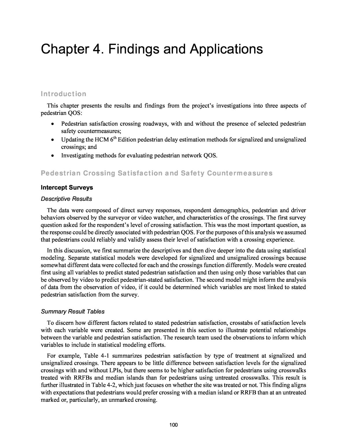
126 Naturalistic Walking Study Model Development After a 7-day period, participants produced linked Empatica E4 streaming and SpyTec GPS data for a total of 21 walking trips. Among these 21 trips, 9 recorded participantsâ GPS location data at 5-second intervals; the remaining 12 trips provided GPS location information at 1-minute intervals. The team expected to receive linked Empatica E4 streaming and SpyTec GPS data for about 60 walking trips in total. However, over the course of the study, several participants reported forgetting to start Empatica E4 sessions upon performing one or more walking trips. Moreover, within three days of involvement in the study, three participantsâ SpyTec GPS devices shut off due to lack of power, although the deviceâs batteries are supposed to last one week. Other participants did not carry their GPS devices with them on walks. Finally, two participants provided linked data for several trips lasting less than 10 minutes, often depicted as walks across UNCâs campus. Although the research team had established a daily data monitoring and reminding protocol, as referenced earlier, the team only obtained linked data for an estimated 35 percent of probable walking trips. Thus, 21 trips were included in the final analysis, which represent a total of 1,693 unique observations at specific locations along the trips. Given the Poisson-like distribution of participantsâ recorded EDA and the fact that data were in ratio form rather than countsâi.e., Poisson regression is appropriate for counts of âevents,â and not for continuous dependent variables, such as participantsâ streaming EDA and heart rate (HR) valuesâthe team estimated multilevel mixed-effects generalized linear models with a gamma distribution and a log link for each of four outcomes of interest (mean and maximum measures of both EDA and HR). A random intercept was fitted to the 21 trips included in the final analysis to account for the unique variation attributable to different trip purposes, destinations, etc. However, to begin, the research team calculated Pearson correlations among the studyâs four dependent variables: participantsâ mean and maximum EDA and mean and maximum HR (Table 4-30). Table 4-30. Correlation among Participantsâ EDA and Heartrate (HR) Readings. Mean EDA Max EDA Mean HR Max HR Mean EDA 1 Max EDA 0.952 1 Mean HR 0.184 0.192 1 Max HR 0.255 0.305 0.897 1 Note: Bolded coefficients denote significant Pearson correlations (p < 0.05). As seen in Table 4-30, participantsâ maximum EDA readings and HR readings were significantly, yet modestly correlated. It is plausible that participantsâ HR elevated during some portions of trips, such when they walked uphill, while their EDA may have indicated relative relaxation. Another factor likely involved the relative volatility of participantsâ EDA, which often varied widely over the course of a walking trip. HR on the other hand, rarely oscillated more than 20 percent throughout a walking trip. Results In general, participantsâ mean and maximum EDA values (i.e., levels of stress) were elevated in environments with industrial and mixed land uses (e.g., offices, retail, residential) located along collector and arterial roadway types. Their stress levels were relatively low in lower-density residential land uses, as well as in forest, park, and university campus environments (Figure 4-1 and Table 4-31).
127 Note: * denotes variables that maintained a statistically significant association with participantsâ EDA averaged over 5-second and 1-minute intervals. Figure 4-1. Participantsâ Mean (left) and Maximum (right) EDA Values while Walking through Various Land Use and Roadway Environments.
128 Table 4-31. Multilevel Mixed-Effects Generalized Linear Model Results for Participantsâ EDA and HR, with a Random Interval Fit at the Level of Participantsâ Trips (n = 21). Mean EDA Max EDA Mean HR Max HR Coef SE Coef SE Coef SE Coef SE Age 0.019 0.056 0.012 0.051 â6.600 2.004 â5.440 2.319 Gender 1.423 0.223 1.016 0.668 7.672 3.166 8.042 3.282 Race Black â â â â â â â â Hispanic 0.714 0.846 0.846 0.769 â1.720 4.076 0.092 4.182 White 0.740 1.524 0.543 1.386 7.286 8.157 6.474 4.061 Study Site 0.016 0.200 0.010 0.184 2.036 3.394 2.695 3.579 Road Type Local â â â â â â â â Collector 0.123 0.124 0.352** 0.116 0.004** 2.467 0.221** 2.887 Arterial 0.120 0.147 0.485** 0.136 â1.132 1.668 â1.066 1.546 Path â0.079 0.113 â0.113** 0.103 2.214 1.637 2.535** 1.879 Sidewalk 0.471** 0.078 0.509** 0.070 2.819 1.202 3.228 1.409 AADT Off-Road â â â â â â â â < 4,000 AADT 0.057 0.301 0.183 0.216 â8.283** 4.048 â10.706 3.943 4,000â9,200 0.239 0.169 0.564 0.155 â2.361 2.622 â3.287 3.069 > 9,200 0.369 0.124 0.501 0.115 â2.876 2.369 â2.873 2.769 Land Use Residential â â â â â â â â Commercial 0.208 0.105 0.281** 0.094 â0.747 1.579 â0.842 1.821 Forest/Park/Campus â0.091** 0.010 â0.079** 0.097 â0.964 1.358 â1.099 0.571 Industrial/Mixed Use 1.033** 0.183 1.115** 0.160 6.264** 2.319 9.180** 2.712 Constant â2.389 2.409 â1.705 2.190 79.129 6.197 82.530 6.429 Trip-level random variable 0.473 0.806 0.390 0.664 24.513 24.336 20.585 21.251 Observations 1,693 1,693 1,693 1,693 Log likelihood â1485.86 â1965.27 â6482.74 â6706.45 X2 (df = 17) 110.24 118.59 54.24 55.73 p 0.000 0.000 0.000 0.000 Notes: SE = standard error; ** = variables with p-values < 0.01. Regarding participantsâ mean and maximum heartrates (HR), these were elevated in land contexts with mixed and industrial uses, as well as along collector roads. Participantsâ HR was lower when walking along paths and when in environments with lower motor vehicle traffic (<4,000 AADT). EDA and HR measures were not significantly associated with participantsâ proximity to study sites (i.e., crossings with LPIs and RRFBs) (Table 4-31 and Figure 4-2).
129 Note: * denotes variables that maintained a statistically significant association with participantsâ HR averaged over 5-second and 1- minute intervals. Figure 4-2. Participantsâ Mean (left) and Maximum (right) HR Values while Walking through Various Land Use and Roadway Environments. Discussion and Conclusion The naturalistic walking study was designed to validate intercept survey and video observation data obtained during Task 6D. As reported in post-study debriefing sessions and verifiedâto the extent possibleâ by GPS data, a handful of participants crossed at study sites equipped with RRFBs, LPIs, and median refuge islands. The statistical models used in this analysis failed to detect significant relationships between participantsâ crossings at study sitesâor crossings more generallyâand their stress levels. It appears that stress was associated with simply walking on a busy street, rather than with the act of crossing the street. Surrounding land uses also interplayed with participantsâ stress levels when walking. Participants experienced greater levels of stress in places with mixed or industrial land uses. Pedestrians, unlike drivers who experience landscapes in a vehicle-mediated and thus dampened fashion, are more exposed to the dynamics of urban environments. Larger roadway types tend to have more traffic than their smaller counterparts, and thus produce higher ambient noise. In locations with many intersections and busy driveways, there is more opportunity for stress-inducing interactions with motor vehicles. These factors likely explain the lack of a significant relationship between pedestriansâ stress levels in proximity to treated or untreated crossings (i.e., those with and without LPI or RRFB treatments).
130 As background noise has been shown to increase cognitive load (Herweg and Bunzeck 2015; Meister et al. 2018), noisier roadways may rapidly deplete pedestriansâ cognitive resources, which can result in lapses of judgement and depressed mood (Berman et al. 2008). On collector and arterial roadways, motor vehicles often travel at higher speeds, which are associated with louder roadway environments. To the human ear, traffic traveling at 65 mph sounds twice as loud as traffic traveling at 30 mph, and 2,000 motor vehicles sound twice as loud as 200 vehicles (FHWA 2017). As traffic noise is positively associated with experiences of psychological stress (e.g., Sygna et al. 2014), it stands to reason that pedestrians in this study, and in similar contexts, would experience higher levels of physiological stress while walking along larger roadways carrying higher motor vehicle volumes. Natural environments, on the other hand, are known to restore what is called âdirected attentionââ âan attentional mechanism that requires effort, that can be brought under voluntary control, and that depends upon inhibition for its operationâ (Kaplan 1995). For example, White and Shah (2019) demonstrate how the human attention system has evolved for interacting with nature and that attention is taxed by urban environments. They explore how exposure to nature can restore peopleâs attention and ameliorate their stress. This helps explain why participantsâ stress levels were modulated in environments with abundant nature, such as forest paths; lower traffic, tree-lined local streets; and on UNCâs oak treeâstrewn campus. This finding is supported by the intercept survey results from Task 6D, where participants reported greater satisfaction with their crossing experiences in locations with less traffic and on lower-classification roadways and where they experienced less delay in crossing. Although this study represents one of the first to examine pedestriansâ physiological states while engaging in mundane walking activity, it contains a few notable limitations. For one, the loss of data from more approximately 40 walking trips precluded the research team from discerning patterns of stress experience within participants. Missing data stemmed predominantly from two sources: (1) participants forgetting to sync their Empatica E4 wristband data stream with their smartphones, forgetting to keep devices charged, or both; and (2) recording information for exceedingly short trips (i.e., most often < 8 minutes in length). Future studies should explore use of devices which integrate GPS and biosensing in a single device, incorporating safeguards for reporting participantsâ location on at least 5-second intervals, and enrolling participants for whom walking is a primary form of transportation. Through passively assessing pedestriansâ physiological reactions to various traffic environments, the research team hoped to substantiate data captured from self-report measures (i.e., intercept surveys) and behavioral observations (i.e., from video observations of crossing behaviors and road user interactions). This triangulation of data collection methods brings us closer to capturing pedestriansâ âtrueâ experiences of varied urban and natural transportation environments. Estimating Pedestrian Delay Uncontrolled Crossings Sensitivity to Traffic Volume This section summarizes the findings from an evaluation of the pedestrian delay prediction methodology in Chapter 20 of the HCM 6th Edition. The evaluation examines the sensitivity of the predicted delay to traffic volume. The investigation reported in Chapter 3 indicated that there was a discontinuity in the predicted pedestrian delay when it is examined for a range of traffic volumes. More importantly, the methodology seemed to over-predict delay when the proportion of motorists yielding is high. The sensitivity analysis findings described in this section are based on the evaluation of pedestrian delay for a four-lane street with a two-way left-turn lane. Pedestrians crossed the street in one stage because there is no median. The following list identifies the input variables and values:
131 ï· Crossing width: 52 ft ï· Pedestrian walking speed: 3.5 ft/s ï· Crosswalk width: 10 ft ï· Pedestrian start-up time: 3 s ï· Pedestrian flow rate: 20 ped/h ï· Traffic volume: 100 to 1100 veh/h Traffic volume was varied over the range of values indicated in the list above. Pedestrian delay was computed for each volume level. The results are shown in Figure 4-3. Three figures are shown; each figure shows the relationship between traffic volume and pedestrian delay for a given pedestrian yield rate. Figure 4-3a corresponds to a motorist yield proportion of 1.0 (i.e., 100% of drivers yield to pedestrians). Figure 4- 3b corresponds to a yield proportion of 0.5 and Figure 4-3c corresponds to a proportion of 0.0 (i.e., no yielding). An examination of Figure 4-3a revealed two issues with the methodology. One issue is the discontinuity in the trend line at a traffic volume of about 370 veh/h. At this volume, the average number of crossing events before an adequate headway (n, changes from 1 to 2. All volumes less than 370 veh/h coincide with a value of n equal to 1. The trend lines predict 30 s delay for a volume of 360 veh/h and 17 s for a volume of 370 veh/h. This significant decrease in delay is unlikely to occur in reality. A second issue is the magnitude of delay being predicted in Figure 4-3a at any volume level. It is logical that delay would be very small (smaller than shown in the figure) for a scenario where all drivers are expected to yield whenever a pedestrian is waiting to cross. An examination of Figure 4-3b indicates the same discontinuity at a volume of 370 veh/h. Additional (but smaller) discontinuities occur at 480, 550, 600, 640, 670, and 700 veh/h. These volume levels correspond to conditions where the value of n increases one integer value. An examination of Figure 4-3b and Figure 4-3c indicates additional discontinuities at volume levels of 820, 990, and 1090 veh/h. Unlike the discontinuities discussed in the previous paragraphs, these discontinuities are associated with a significant increase in delay. These discontinuities coincide with a change in the spatial distribution of pedestrians (Np). For example, the discontinuity at a volume level of 820 veh/h results when Np changes from 1 to 2. All volumes less than 820 veh/h coincide with a value of Np equal to 1. The value of Np increases with an increase in volume.
132 a. Proportion motorists yielding equal to 1.0. b. Proportion motorists yielding equal to 0.5. c. Proportion motorists yielding equal to 0.0. Figure 4-3. Influence of Vehicular Traffic Volume on Pedestrian DelayâExisting Methodology.
133 Findings This section summarizes the findings from an evaluation of the revised pedestrian delay prediction methodology. The evaluation examines the sensitivity of the predicted delay to traffic volume. The first subsection examines the influence of the Revision Group 1 changes. The section subsection examines the influence of both Groups 1 and 2 combined. The input variable values used to develop Figure 4-3 were also used for this analysis to facilitate comparison between the HCM methodology and the revised methodology. Revision Group 1 Changes Figure 4-4 illustrates the relationship between pedestrian delay and traffic volume. The trend lines formed by circles represent the delay predicted by the existing HCM methodology. The solid trend line represents the delay predicted by the HCM methodology with the Group 1 revisions. The revised-methodology trend line indicates a smooth relationship (i.e., no discontinuity) for the range of traffic volumes considered. More importantly, the revised-methodology trend line indicates that the delay is much lower than predicted by the existing HCM methodology. Both trends are consistent with intuition. That is, there should be no discontinuity and there should be negligible delay when all motorists yield to pedestrians. Revision Group 1 and 2 Changes Figure 4-5 illustrates the relationship between pedestrian delay and traffic volume when both the Group 1 and Group 2 revisions are implemented in the methodology. As before, the solid trend line represents the delay predicted by the HCM methodology with the Group 1 revisions. The dashed trend line represents the delay predicted by HCM methodology with both the Group 1 and 2 revisions. Most notably, the dashed trend line is shown to remove the discontinuities associated with the use of Equation D9 to compute the spatial distribution of pedestrians Np. The influence of the Group 2 revisions is shown in the figure to be more influential when the motorist yield rate My is less than 1.0.
134 a. Proportion motorists yielding equal to 1.0. b. Proportion motorists yielding equal to 0.5. c. Proportion motorists yielding equal to 0.0. Figure 4-4. Influence of Vehicular Traffic Volume on Pedestrian DelayâGroup 1 Revisions.
135 a. Proportion motorists yielding equal to 1.0. b. Proportion motorists yielding equal to 0.5. c. Proportion motorists yielding equal to 0.0. Figure 4-5. Influence of Vehicular Traffic Volume on Pedestrian DelayâGroup 1 & 2 Revisions.
136 Proposed Motorist Yield Rates This section presents the proposed motorist yield rates for selected engineering treatments at uncontrolled pedestrian crossings. The literature review findings in Table 3-12, combined with additional data developed from the Task 6D video observations (described above) were used as the basis for determining the proposed rates. The motorist yield rates reported in Table 3-12 were checked to confirm that the original researchers used a common method for calculating yield rate. Specifically, these researchers calculated yield rate as the percentage of motorists that yielded or stopped when one or more pedestrians were present. The proposed motorist yielding rates were calculated as a weighted average of the reported motorist yield rates, where sample size was used as the weight factor. The sample size was represented either by the number of sites or the number of pedestrian crossings. The research team used one sample size unit while calculating the weighted average of motorist yield rates (in terms of number of sites or the number of pedestrian crossings). Those studies that did not provide sample size information (in terms of sites or pedestrians for the specific engineering treatment) were not used in calculating the weighted average of the motorist yield rates. The weighted average was computed using the following equation: ð?Ì? = â (ðð¦,ð à ð ð ð ð=1 ) â ð ð ð ð=1 Equation 58 where ð?Ì? = average motorist yield rate (decimal); My,i = motorist yield rate for study i (decimal); and si = sample size (in terms of number of sites or pedestrians) for study i. The proposed motorist yielding rates are summarized in Table 4-32 for each of 14 crossing treatments. Table 4-32. Proposed HCM Default Motorist Yield Rates for Alternative Pedestrian Crossing Treatments. Crossing Treatment Yield Rate (%) Sample Size Average Range (sites) No treatment (unmarked) 24 0â100 37 Crosswalk markings only (any type) 34 0â95 55 Crosswalk markings, plus: Pedestal-mounted flashing beacon 35 12â57 2 Overhead sign 37 0â52 6 Overhead flashing beacon (push-button activation) 51 13â91 14 Overhead flashing beacon (passive activation) 73 61â76 29 In-roadway warning lights 58 53â65 11 Median refuge island 60 0â100 21 Pedestrian crossing flags 74 72â80 6 In-street pedestrian crossing signs 74 35â88 17 RRFB 79 45â100 42 School crossing guard 86 â 1 School crossing guard and RRFB 92 â 1 Pedestrian hybrid beacon (HAWK) 88 83â100 69 Midblock crossing signals, half signals 98 96â100 6 Sources: NCHRP Project 17-87 data collection, Huang et al. (2000), Fitzpatrick et al. (2006), Turner et al. (2006), Banerjee and Ragland (2007), Ellis Jr. et al. (2007), Shurbutt et al. (2008), Mitman et al. (2008), Pécheaux et al. (2009), Mitman et al. (2010), Ross et al. (2011), Brewer and Fitzpatrick (2012), Fitzpatrick et al. (2014), Nemeth et al. (2014), Yang et al. (2015), Zheng and Elefteriatou (2017), Schneider et al. (2017), Al-Kaisy et al. (2018), and Hockmuth and Van Houten (2018).
137 Validation of Pedestrian Delay Method for Uncontrolled Crossings Database Summary This section provides a summary of the data collected at each site during each study period. The first subsection describes the study site location and geometry. The second subsection provides a summary of the key traffic characteristics and performance measures measured at each site. Study Sites The characteristics of the 20 study sites represented in the validation database are shown in Table 4-33. Eleven sites are located in Portland, Oregon and the remaining sites are located in Chapel Hill, North Carolina. The street on which the subject crosswalk is located is described in the last three columns of the table. The speed limit in the set of sites ranges from 20 to 35 mph. The AADT volume ranges from 3,600 to 41,000 vehicles per day. Table 4-33. Study Site Characteristics. Site No. Location (City, State) Site Name Description of Street Being Crossed Street Name Speed Limit (mph) AADT (veh/day) 1 Portland, OR SE 80th Ave. & SE Stark St. SE Stark St. 20 10,600 2 Chapel Hill, NC S Columbia St. (by Merrittâs) S Columbia St. 35 14,000 3 Chapel Hill, NC Estes Dr. & Wilson Park Trail Estes Dr. 35 13,900 4 Chapel Hill, NC Willow Dr. & S Mall Entrance Willow Dr. 25 9,000 5 Chapel Hill, NC W Franklin St. & N. Roberson St. W Franklin St. 25 15,000 6 Portland, OR NE Glisan St. & NE 80th Ave. NE Glisan St. 30 16,400 7 Portland, OR SE Hawthorne Blvd. & SE 46th Ave. SE Hawthorne Blvd. 20 14,500 8 Portland, OR NE MLK Blvd. & NE Sumner St. NE MLK Blvd. 30 29,700 9 Portland, OR NE 33rd Ave. & NE Emerson St. NE 33rd Ave. 30 15,000 10 Portland, OR NE 33rd Ave. & NE Shaver St. NE 33rd Ave. 30 15,000 11 Portland, OR NE MLK Blvd. & NE Graham St. NE MLK Blvd. 30 29,700 12 Portland, OR NE 26th Ave. & E. Burnside St. E. Burnside St. 30 17,400 13 Chapel Hill, NC Pittsboro St. & Dauer Dr. Pittsboro St. 25 8,300 14 Chapel Hill, NC Pittsboro St. & Vance St. Pittsboro St. 25 8,500 15 Chapel Hill, NC Seawell School Rd. & High School Rd. Seawell School Rd. 35 3,600 16 Chapel Hill, NC Willow Dr. (at Willow Terrace Apts.) Willow Dr. 25 7,900 17 Portland, OR NE Sandy Blvd. & NE 17th Ave. NE Sandy Blvd. 30 25,100 18 Portland, OR SE Powell Blvd. & SE 36th Ave. SE Powell Blvd. 35 41,000 19 Chapel Hill, NC South Rd. & Stadium Dr. South Rd. 25 7,400 20 Portland, OR SW 37th Ave. & SW Vermont St. SW Vermont St. 35 9,400 The streets on which the subject crosswalk is located were selected to collectively offer a range of geometric features. These features are listed in Table 4-34. The sites are shown to have either an undivided or a two-way-left-turn lane cross-section. Candidate sites having a divided cross-section were not included in this validation analysis because the median could function as a refuge for some pedestrians (and not for others). Those pedestrians that used the median as a refuge would effectively be crossing two one-way
138 streets (one at a time). Those pedestrians that did not stop on the median would effectively be crossing a two-way street. Each of these two scenarios would have different delay implications and would require a distinctly different application of the HCM methodology. To avoid this complication (and associated uncertainty to the predicted delays), the validation analysis focused on streets where the crossing maneuver should always be completed in one stage. The possible influence of right-turn lanes was previously discussed as a complicating factor in the validation analysis. For this reason, the two sites with a right-turn lane were excluded from the database. A similar concern is present for sites with a left-turn lane. However, sites with left-turn lanes were kept in the database given their prevalence at unsignalized crossing locations and, thus, the need to conduct a validation analysis for these locations. The presence of left-turn lanes was recorded (as shown in column 6 of Table 4-34) to facilitate the evaluation of this influence on pedestrian delay. Table 4-34. Geometric Features of the Street Being Crossed. Site No. Street Name Travel Directions Supported Cross- Section Type Number of Through Lanes Number of Left-Turn Lanes Pedestrian Crossing Distance (ft) 1 SE Stark St. One way Undivided 2 0 43 2 S Columbia St. Two way Undivided 2 1 44 3 Estes Dr. Two way Undivided 2 0 32 4 Willow Dr. Two way TWLTL 2 1 35 5 W Franklin St. Two way Undivided 4 0 60 6 NE Glisan St. Two way TWLTL 2 1 50 7 SE Hawthorne Blvd. Two way TWLTL 2 1 53 8 NE MLK Blvd. Two way Undivided 4 0 56 9 NE 33rd Ave. Two way Undivided 2 0 24 10 NE 33rd Ave. Two way Undivided 2 0 37 11 NE MLK Blvd. Two way Undivided 4 0 45 12 E. Burnside St. Two way TWLTL 3 1 55 13 Pittsboro St. One way Undivided 2 0 30 14 Pittsboro St. One way Undivided 2 0 30 15 Seawell School Rd. Two way Undivided 2 1 50 16 Willow Dr. Two way Undivided 2 0 35 17 NE Sandy Blvd. Two way Undivided 4 0 58 18 SE Powell Blvd. Two way TWLTL 4 1 60 19 South Rd. Two way Undivided 2 1 40 20 SW Vermont St. Two way Undivided 2 0 40 Note: TWLTL = two-way left-turn lane. Summary Statistics The traffic data collected for each site and study period are summarized in Table 4-35. At each site, data were collected during a weekday and a weekend day. The weekday study period was typically from 4:00 to 6:00 pm. The weekend day study period was typically from 12:00 to 2:00 pm. Vehicle volume during the study periods ranged from 120 to 2,693 vehicles per hour. The low pedestrian volume at some sites limited the number of observations of the âfirst driver able to stopâ and pedestrian delay.
139 Motorist yield rates are shown in the last column of Table 4-35. In general, one rate was computed for each combination of site and study period. The rates are shown to range from 0.333 to 1.000. To ensure reasonable statistical validity in the computed motorist yield rates at a given site, the observations for any study period for which there were fewer than nine observations was combined with the observations for the other study period at the same site. In this situation, the pooled data were used to compute one motorist yield rate for the site. The measured pedestrian volumes, pedestrian crossing times, and pedestrian delays are shown in Table 4-36. The pedestrian volumes range from 1 to 128 pedestrians per hour. The pedestrian crossing times range from 4.8 to 14.9 seconds. The delays range from 0.2 to 15.8 seconds per pedestrian. Validation Process The model validation process consisted of a series of steps that facilitated a comparison of delay estimates from the revised HCM model with the measured delay at the study sites. As a first step of the process, the overall average walking speed was estimated. This speed was computed by dividing the measured pedestrian crossing distance by the measured average crossing time. It was then used in Step 2 of the HCM methodology to estimate the critical headway for a single pedestrian tc. The second step of the validation process entailed using the aforementioned critical headway in the remaining steps of the HCM methodology to compute the predicted average pedestrian delay. The measured vehicle and pedestrian volumes were used as input values to the HCM methodology to further tailor the calculation of the predicted delay to each site and study period combination. The third step of the validation process entailed using graphical presentations and statistical measures to assess the fit of the predicted delay estimates to the measured delay estimates. It was during this step that a determination was made regarding the need for an empirical adjustment to the model to remove any observed bias in the predicted delay. Fortunately, no bias was found and the empirical adjustment was not needed. The findings from this step are discussed in the next section.
140 Table 4-35. Traffic Characteristics at the Subject CrossingâMotorized Vehicles. Site No. Street Name Day Type Study Period Vehicle Volume (veh/h) Motorist Yield Data Motorist Observations Motorist Yield Rate (decimal) 1 SE Stark St. Weekday 4:00-6:00 pm 785 32 0.625 Weekend 12:00-2:00 pm 747 69 0.986 2 S Columbia St. Weekday 11:50-1:50 pm 1159 22 1.000 Weekend 12:00-2:00 pm 969 153 0.333 3 Estes Dr. Weekday 4:00-6:00 pm 1120 7 0.750 Weekend 12:00-2:00 pm 990 5 4 Willow Dr. Weekday 4:00-6:00 pm 676 12 0.471 Weekend 12:00-2:00 pm 630 5 5 W Franklin St. Weekday 4:00-6:00 pm 862 23 0.913 Weekend 12:00-2:00 pm 791 56 0.839 6 NE Glisan St. Weekday 4:00-6:00 pm 1449 13 0.947 Weekend 12:00-2:00 pm 1493 6 7 SE Hawthorne Blvd. Weekday 4:00-6:00 pm 1033 24 0.500 Weekend 12:00-2:00 pm 919 41 0390 8 NE MLK Blvd. Weekday 4:00-6:00 pm 1960 121 0.785 Weekend 12:00-2:00 pm 1842 68 0.750 9 NE 33rd Ave. Weekday 4:00-6:00 pm 1197 181 0.989 Weekend 12:00-2:00 pm 892 68 0.926 10 NE 33rd Ave. Weekday 4:00-6:00 pm 1296 5 0.556 Weekend 12:00-2:00 pm 1065 4 11 NE MLK Blvd. Weekday 4:00-6:00 pm 2220 20 0.700 Weekend 12:30-2:30 pm 1727 16 0.500 12 E. Burnside St. Weekday 4:00-6:00 pm 2052 24 0.833 Weekend 12:00-2:00 pm 1133 16 0.813 13 Pittsboro St. Weekday 4:00-6:00 pm 655 7 0.571 Weekend 12:00-2:00 pm 390 0 14 Pittsboro St. Weekday 4:00-6:00 pm 651 114 0.974 Weekend 12:00-2:00 pm 556 9 0.556 15 Seawell School Rd. Weekday 4:00-6:00 pm 620 14 0.867 Weekend 12:00-2:00 pm 120 1 16 Willow Dr. Weekday 4:00-6:00 pm 508 8 0.889 Weekend 12:00-2:00 pm 420 1 17 NE Sandy Blvd. Weekday 4:00-6:00 pm 2120 7 0.550 Weekend 12:00-2:00 pm 940 13 18 SE Powell Blvd. Weekday 4:00-6:00 pm 2693 36 0.972 Weekend 12:00-2:00 pm 2415 42 0.952 19 South Rd. Weekday 4:00-6:00 pm 800 4 0.667 Weekend 6:50-8:50 pm 700 2 20 SW Vermont St. Weekday 4:00-6:00 pm 885 2 0.500 Weekend 4:00-6:00 pm 375 5 0.600
141 Table 4-36. Traffic Characteristics at the Subject CrossingâPedestrians. Site No. Street Name Day Type Pedestrian Volume (ped/h) Pedestrian Crossing time (s) Pedestrian Delay (s/p) 1 SE Stark St. Weekday 25.5 8.9 2.6 Weekend 64.5 10.3 1.1 2 S Columbia St. Weekday 71.0 10.1 12.4 Weekend 128.0 10.1 9.7 3 Estes Dr. Weekday 3.0 5.7 6.8 Weekend 3.0 5.0 3.0 4 Willow Dr. Weekday 9.5 8.6 1.9 Weekend 3.0 8.2 0.3 5 W Franklin St. Weekday 19.5 12.6 5.1 Weekend 53.0 12.8 6.0 6 NE Glisan St. Weekday 4.0 11.8 2.6 Weekend 4.5 12.9 3.1 7 SE Hawthorne Blvd. Weekday 14.5 13.8 2.4 Weekend 33.0 14.9 2.7 8 NE MLK Blvd. Weekday 29.5 11.5 3.3 Weekend 18.0 11.3 4.0 9 NE 33rd Ave. Weekday 87.5 5.4 1.9 Weekend 54.0 4.8 1.8 10 NE 33rd Ave. Weekday 3.5 7.9 4.9 Weekend 2.0 6.2 4.8 11 NE MLK Blvd. Weekday 5.5 10.2 4.8 Weekend 6.0 8.8 5.3 12 E. Burnside St. Weekday 20.0 10.1 10.3 Weekend 10.0 10.6 2.9 13 Pittsboro St. Weekday 12.0 6.5 6.4 Weekend 3.0 6.3 0.2 14 Pittsboro St. Weekday 90.5 6.3 2.9 Weekend 7.5 6.3 1.8 15 Seawell School Rd. Weekday 9.5 9.7 3.5 Weekend 1.5 8.1 1.8 16 Willow Dr. Weekday 11.5 8.1 1.6 Weekend 1.0 6.7 4.4 17 NE Sandy Blvd. Weekday 3.0 12.2 9.9 Weekend 10.0 11.2 15.8 18 SE Powell Blvd. Weekday 8.5 10.4 3.2 Weekend 13.0 12.9 3.6 19 South Rd. Weekday 1.5 9.5 5.4 Weekend 2.5 9.8 13.3 20 SW Vermont St. Weekday 2.0 8.4 2.2 Weekend 13.5 10.7 3.8
142 Findings This section documents the findings from the validation analysis. It consists of two subsections. The first subsection describes the findings from the evaluation of average walking speed. The second subsection describes the findings from the validation of the revised model for predicting pedestrian delay. Crosswalk Walking Speed The measured crossing time was divided into the measured crossing distance to compute the average crosswalk walking speed for each of the site and study period combinations. The average walking speed was computed as 4.7 ft/s with a range of 3.6 to 6.5 ft/s across the 40 combinations. An exploratory analysis investigated the possible influence of state (i.e., Oregon vs North Carolina), pedestrian volume, vehicle volume, and crossing distance on walking speed. None of these variables were found to have statistically significant influence on speed. However, it was noted that speed tended to decrease with an increase in pedestrian volume. This influence of pedestrian volume is consistent with the pedestrian walking speed prediction equation cited in HCM Chapter 18. The average walking speed of 4.7 ft/s that was computed from the data is slightly larger than the sidewalk free-flow walking speed of 4.4 ft/s that is recommended in HCM Chapter 18. The pedestrians observed at the study sites typically crossed alone or as a group of two. Thus, in general, they are considered to have been walking in a free-flow condition during the study period. The fact that the observed average crosswalk walking speed of 4.7 ft/s is larger than the sidewalk walking speed of 4.4 ft/s suggests that pedestrians in the crosswalk desire to minimize their âtime exposureâ to conflicting vehicles by walking quickly. It should be noted that HCM Chapter 20 (which documents the delay prediction methodology discussed here) recommends a default pedestrian crossing speed of 3.5 ft/s. All of the study sites had an average walking speed in excess of 3.5 ft/s. The average walking speed of 4.7 ft/s was divided into the crossing distance to compute the predicted crossing time. This predicted crossing time was then examined graphically over the range of crossing times found at the study sites. A comparison of the predicted and measured crossing times is shown in Figure 4- 6. The predicted crossing time is shown in the figure to provide an unbiased estimate of the measured crossing time over the range of 5 to 13 seconds crossing time. The R2 value of 0.75 indicates that the predicted crossing time explains about 75 percent of the variation in the measured crossing times. Figure 4-6. Comparison of Predicted and Measured Crossing Time.
143 Pedestrian Delay The revised model (described in Chapter 3) was used to calculate the average pedestrian delay for each of the site and study period combinations. As part of this calculation, the walking speed of 4.7 ft/s was used to calculate the âcritical headway for a single pedestrianâ tc for each site. This calculation used the following equation. ð¡ð = ð¿ ðð + ð¡ð Equation 59 where tc = critical headway for a single pedestrian (s), Sp = average pedestrian walking speed (ft/s), L = crosswalk length (ft), and ts = pedestrian start-up time and end clearance time (default: 3.0 s) (s). The measured pedestrian volume and the measured vehicle volume were used to compute average pedestrian group size and group critical headway. The measured vehicle volume was also used to compute the probability of a delayed crossing and the average delay when waiting for an adequate gap to cross. The measured motorist yield rate was used to compute the probability that motorists would yield to pedestrians waiting to cross the traffic lanes at each site. This rate and the other intermediate results were then used to compute the average pedestrian delay. The predicted and measured pedestrian delay values were assessed using graphical presentations and statistical measures. An exploratory analysis investigated the prediction âerrorâ (= measured delay â predicted delay) and the squared error. The intent of the investigation was to understand the conditions that might be associated with relatively large errors. The analysis revealed that the âpedestrian start-up time and end clearance timeâ variable ts in Equation 59 had a significant effect on the magnitude of the error. Further investigation revealed that reducing the value of this variable from the default value of 3.0 s to 0.0 s greatly reduced the overall square error. This trend suggests that pedestrians at the study sites tend to be anticipating the arrival of an adequate gap (i.e., they do not require any start-up time) and start immediately upon its arrival. It also suggests that they are not requiring any end clearance time. However, it is more likely that (1) they do not need as much end clearance time as suggested by the 3.0 s value and (2) the vehicle defining the end of the adequate gap is often not traveling in the last lane crossed by the pedestrian (hence, crossing safety is assured spatially by lane separation rather than temporally by a second or two of clearance time). For these reasons, the value of ts was retained as 0.0 s for the presentation of validation results. The exploratory analysis also revealed that the presence of a left-turn lane had an influence on the squared error value. As a result, the sites were grouped into two sets. One set included all sites that do not have a left-turn lane in the path of the crosswalk. The other set included all sites that have a left-turn lane in the path of the crosswalk. A comparison of the predicted and measured average delays in the first and second sets is shown in Figures 4-7 and 4-8, respectively.
144 Figure 4-7. Comparison of Predicted and Measured DelayâCrossings without a Left-turn Lane. Figure 4-8. Comparison of Predicted and Measured DelayâCrossings with a Left-turn Lane. Two factors should be noted as relates to the variation in the data shown in Figures 4-7 and 4-8. First, field-measured delays have highly variable values. As a result, a relatively large number of delay observations must be measured at a given site to produce a stable estimate of the siteâs expected average delay. The relatively light pedestrian volumes at most study sites resulted in there being a relatively small sample of delay observations at these sites. As a result, the uncertainty in the delay data is relatively high. Second, statistics that describe overall model fit (e.g., R2) can provide a more reliable indication of goodness-of-fit when there is a wide range in the independent variable (i.e., predicted delay). As shown in the figures, the predicted delays are in a relatively narrow range of 1 to 13 s/p. Delays in excess of 13 s/p would be found at sites where the volume is high and the motorist yield rate is low. However, the higher- volume sites in this study typically have a high yield rate because they have a special treatment applied at the crossing location to encourage motorist yielding to pedestrians. As a result, the range in the predicted delay at the set of sites studied is relatively small and limited to pedestrian delays associated with levels of service A, B, or C.
145 The data in Figure 4-7 show that the revised model can provide an unbiased prediction of the delay for crossings that do not include a left-turn lane. The R2 of 0.36 suggests that the predictive model explains about 36 percent of the variability in the measured delay data. If the value of ts is changed to 3.0, several sites have an exceptionally large predicted delay (and associated error) such that the R2 is effectively zero. If the revisions described in Chapter 3 are not applied (i.e., the HCM methodology is used without revision), the predicted delay overestimates the measured delay by a factor of about 3.7 (i.e., measured delay = 0.27 Ã predicted delay) and the R2 is reduced to 0.31. If the revisions are not applied and the value of ts is changed to 3.0, several sites have an exceptionally large predicted delay (and associated error) such that the R2 is effectively zero. The data in Figure 4-8 show weak correlation between the predicted and measured delay for crossings that include a left-turn lane. In fact, the R2 is negligibly small. The data appear to be located around the diagonal line (i.e., the line where predicted values equal measured values) which suggests that there is no bias in the predictionâjust a large degree of uncertainty. As noted previously for right-turn lanes, the presence of a left-turn lane is not explicitly recognized in the HCM methodology. This methodology is based on the evaluation of traffic lanes in which the vehicles are moving at relatively constant speed and the volume is somewhat evenly distributed. Vehicles in a turn lane are decelerating and typically have a volume that is notably smaller than that of the adjacent through lanes. The data in Figure 4-8 indicate that the predicted pedestrian delay is much larger than the measured delay at some sites. Yet, at other sites, the opposite trend is found. The presence of a left-turn lane could increase pedestrian delay at a site if the left-turning vehicle is stopped at the crosswalk waiting for a gap in opposing vehicle traffic and the waiting pedestrians doubt that the left-turn driver will yield to them should they cross in front of the vehicle (so they do not start their crossing). On the other hand, the presence of a left-turn lane could decrease pedestrian delay if the unoccupied left-turn lane is used as a pedestrian refuge area (such that the crossing can be completed in two stages). HCM Street-Crossing Difficulty Factor Sensitivity Analysis This section summarizes the findings from an evaluation of the pedestrian segment LOS prediction methodology in NCHRP Report 616 (Dowling et al. 2008) and in Chapter 18 of the HCM 6th edition. The evaluation examines the sensitivity of the predicted segment LOS score to changes in link LOS score, roadway crossing difficulty, and segment length. Sensitivity to Link and Intersection LOS Scores The motivation for this evaluation was the findings reported in Chapter 3. Notably, it was found that the change to Equation 54 (from Equation 52) was needed to improve the sensitivity of segment LOS score to link LOS score, especially for links with a poor LOS score. This analysis investigates the degree to which this improvement was achieved. The sensitivity analysis findings described in this section are based on the evaluation of pedestrian segment LOS score for a street segment. The following list identifies the input variables and values: ï· Pedestrian LOS score for intersection, Ip,int: 1, 2, 3, 4, 5, 6 ï· Pedestrian LOS score for link, Ip,link: equal to Ip,int ï· Walking speed, Sp: 4 ft/s ï· Segment length, L: 330 ft
146 ï· Pedestrian delay incurred in walking parallel to the segment, dpp: equal to 0.1 Ã L/Sp ï· Roadway difficulty crossing factor, Fcd: 1.0 The intersection LOS score (which equals the link score) was varied over the range of 1 to 6. Equation 52 and Equation 54 were used to compute the segment LOS score. The results are shown in Figure 4-9. The solid trend line shows the predicted segment LOS score using Equation 52. The dashed line shows the predicted segment LOS score using Equation 54. The slope of the dashed line is shown to be steeper than that of the solid line indicating that Equation 54 provides greater sensitivity to the intersection and link LOS scores, as intended by Petritsch and Scorsone (2014). Figure 4-9. Influence of Intersection and Link LOS Score on Segment LOSâExisting Methodology. For the conditions stated in the bullet list above (i.e., the link LOS score equals the intersection LOS score), the expectation should be that the predicted segment LOS score would equal that of the intersection and link. For example, if the intersection LOS score is 1.0, the link LOS score is 1, and the roadway crossing difficulty factor is 1.0, the expectation is that the segment LOS score should also equal 1.0. It is difficult to imagine a situation where any value other than 1.0 could be rationalized for the stated conditions. However, as shown in Figure 4-9, neither equation predicts a segment LOS value of 1.0. Similarly, when the intersection LOS score is 6.0, the link LOS score is 6, and the roadway crossing difficulty factor is 1.0, the expectation is that the segment LOS score should also equal 6.0. However, as shown in Figure 4-9, neither equation predicts a segment LOS value of 6.0. Specific values of walking speed, segment length, and pedestrian delay are cited in the bullet list at the start of this section. These variables are used only in Equation 54 (i.e., HCM 6th Edition). However, the trends in Figure 4-9 for the HCM equation are insensitive to the values selected for these variables because the link and intersection LOS scores are the same. Sensitivity to Roadway Crossing Difficulty The motivation for this evaluation was the findings reported in Chapter 3 regarding the application of the roadway crossing difficulty factor. Notably, it was found that this factor was applied to only the link LOS score in Equation 54. In contrast, the factor was applied to both the link LOS score and the intersection LOS score in Equation 52.
147 The sensitivity analysis findings described in this section are based on the evaluation of pedestrian segment LOS score for a street segment. The following list identifies the input variables and values: ï· Pedestrian LOS score for intersection, Ip,int: 1, 2, 3, 4, 5, 6 ï· Pedestrian LOS score for link, Ip,link: equal to Ip,int ï· Walking speed, Sp: 4 ft/s ï· Segment length, L: 330 ft ï· Pedestrian delay incurred in walking parallel to the segment, dpp: equal to 0.1 Ã L/Sp ï· Roadway difficulty crossing factor, Fcd: 0.8, 1.2 The intersection LOS score (which equaled the link score) was varied over the range of 1 to 6. The roadway crossing difficulty factor was assigned values of 0.8 and 1.2. Equation 52 and Equation 54 were used to compute the segment LOS score. The results are shown in Figure 4-10. The solid trend line shows the predicted segment LOS score using Equation 52. The dashed line shows the predicted segment LOS score using Equation 54. One pair of trend lines correspond to a roadway crossing difficulty factor of 0.8 and one pair correspond to a factor of 1.2. Figure 4-10. Influence of Roadway Crossing Difficulty on Segment LOSâExisting Methodology. The two solid trend lines in Figure 4-10 indicate that the segment LOS score ranges from 1.7 to 2.6 (a difference of 0.9) when the link and intersection LOS scores are 1.0. When the link and intersection scores are 6.0, this range increases to 1.9. In contrast, the two dashed trend lines have a range of 0.3 and 1.6 for link/intersection LOS scores of 1.0 and 6.0, respectively. The aforementioned ranges describe the maximum possible effect of roadway crossing difficulty on segment LOS. The ranges associated with the original research by Dowling et al. (2008) (i.e., NCHRP Report 616) suggest that crossing difficulty can have a relatively large effect on segment LOS. However, the rationally based changes by Petritsch and Scorsone (2014) have indirectly reduced the range and associated impact potential of crossing difficulty on segment LOS. Sensitivity to Segment Length This section summarizes the findings from an evaluation of segment LOS score as influenced by segment length. Segment length is a variable in Equation 54 so it has a direct influence on the segment LOS score for the HCM methodology. Segment length is also used in Equation 45 to compute the pedestrian diversion delay. This delay is then used in the NCHRP Report 616 methodology and the HCM methodology to
148 compute the roadway crossing difficulty factor. This factor is then used in Equation 52 and Equation 54 to compute the segment LOS score for each of the two methodologies. The sensitivity analysis findings described in this section are based on the evaluation of pedestrian segment LOS score for a street segment. The following list identifies the input variables and values: ï· Pedestrian LOS score for intersection, Ip,int: 3 ï· Pedestrian LOS score for link, Ip,link: 3 ï· Pedestrian waiting delay, dpw: 50 s/p ï· Walking speed, Sp: 4 ft/s ï· Segment length, L: 330, 660, 990, 1320 ft ï· Pedestrian delay incurred in walking parallel to the segment, dpp: 6 s/p ï· Pedestrian delay incurred in crossing the segment at the nearest signal, dpc: 23 s/p Using Equation 45, the variables in the preceding list result in pedestrian diversion delays dpd of 78, 133, 188, and 243 s/p for segment lengths of 330, 660, 990, and 1,320 ft; respectively. These delays exceed the pedestrian waiting delay of 50 s/p so pedestrians are assumed to prefer to cross the street without diverting. As a result, diversion delay (and segment length) does not influence the computed roadway crossing difficulty factor value. This finding is contrary to that of Chu and Baltes (2001), who found that crossing difficulty is influenced by segment length. The segment length was varied over the range of values shown in the previous list. The two aforementioned methodologies were used to compute the segment LOS score. The results are shown in Figure 4-11. The solid trend line shows the predicted segment LOS score using the NCHRP Report 616 methodology. The dashed line shows the predicted segment LOS score using the HCM methodology. Figure 4-11. Influence of Segment Length on Segment LOSâExisting Methodology. The trend lines in Figure 4-11 indicate that segment length has negligible influence on the segment LOS score. This finding holds for link LOS scores in the range of 1 to 6 and for intersection LOS scores in the range of 1 to 6. It also holds for any value of pedestrian waiting delay.
149 Sensitivity Analysis This section summarizes the findings from an evaluation of the revised pedestrian segment LOS prediction methodology. The evaluation examines the sensitivity of the predicted segment LOS score to changes in link LOS score, roadway crossing difficulty, and segment length. The input variable values used to develop Figures 4-9 to 4-11 were also used for this analysis to facilitate comparison between the HCM methodology and the revised methodology. Sensitivity to Link and Intersection LOS Scores Figure 4-12 illustrates the relationship between the link/intersection LOS score and segment LOS score. The solid trend line and the dashed trend line were previously shown in Figure 4-9. The âdot-dashâ trend line reflects the predicted segment LOS using the proposed Equation 57. For this analysis, the midsegment LOS score was also assumed to equal the link and intersection LOS scores. Unlike the other two trend lines, the dot-dash trend line has the desirable characteristic of predicting a segment LOS score that equals the link/intersection LOS scores when the link and intersection scores are equal. Figure 4-12. Influence of Intersection and Link LOS Score on Segment LOSâProposed Changes. Sensitivity to Roadway Crossing Difficulty Figure 4-13 illustrates the relationship between the link/intersection LOS score and segment LOS score for various levels of roadway crossing difficulty. The solid trend line and the dashed trend line were previously shown in Figure 4-8. The two âdot-dashâ trend lines reflect the predicted segment LOS using the proposed Equation 57. One trend line corresponds to a midsegment LOS score Ip,mx of 1.0. The other trend line corresponds to a midsegment LOS score of 6.0. For this analysis, the proportion of pedestrian demand that desires to cross at a midsegment location pmx was set to 0.35.
150 Figure 4-13. Influence of Roadway Crossing Difficulty on Segment LOSâProposed Changes. The two dot-dash trend lines in Figure 4-13 (corresponding to the proposed changes) indicate that the segment LOS score ranges from 1 to 2.7 (a difference of 1.7) when the link and intersection LOS scores are 1.0. When the link and intersection scores are 6.0, this range is 1.5. The dot-dash trend line for the midsegment LOS score of 6.0 is almost identical to that for NCHRP Report 616 when the crossing difficulty factor is 1.2. The proposed change provides a wider range of segment LOS scores than the HCM methodology for link/intersection LOS scores smaller than about 5.0. The additional range width at link/intersection LOS scores less than 5.0 are created by the dot-dash trend line associated with a midsegment LOS score of 1.0. As discussed in the previous section, this trend line passes through the point where the link/intersection LOS score, the midsegment LOS score, and the segment LOS score all equal 1.0, which is a logical boundary condition. Sensitivity to Segment Length Figure 4-14 illustrates the relationship between the segment LOS score and segment length for various levels of link/intersection LOS score. The solid trend line and the dashed trend lines in Figure 4-14b were previously shown in Figure 4-11. The âdot-dashâ trend line reflects the predicted segment LOS using the proposed changes to the HCM methodology. For the given input variable values (i.e., the variables identified in the discussion of Figure 4-11), the midsegment LOS score ranges from 3.2 to 4.6. The lower and upper limits of this range correspond to segment lengths of 330 and 1,320 feet, respectively. The trend lines in Figure 4-14 for the HCM and for the NCHRP Report 616 methodologies are horizontal which indicates that their predicted segment LOS score is not sensitive to segment length. In contrast, the dot-dash trend line representing the proposed changes does indicate a logical increase in the segment LOS score with increasing segment length. In general, the proposed changes provide a predicted segment LOS score that is between (or near) that predicted by the HCM and NCHRP Report 616 methodologies. In Figure 4-14b, the proposed changes yield a predicted segment LOS of 3.1 for the 330-ft segment length. Even though this value is outside the range shown for the HCM and NCHRP Report 616 methodologies, the value of 3.1 is logical given that the link and intersection LOS scores are 3.0 and the midsegment LOS score is 3.2.
151 a. Link LOS Score and Intersection LOS Score equal to 1.0. b. Link LOS Score and Intersection LOS Score equal to 3.0. c. Link LOS Score and Intersection LOS Score equal to 6.0. Figure 4-14. Influence of Segment Length on Segment LOSâProposed Changes.
152 Pedestrian Network LOS Comparison of PLOS and PLTS The research team applied the HCM PLOS and ODOT PLTS methodologies to collector and arterial roadway segments for the entire state of Florida, using GIS shapefiles obtained from the FDOT Transportation Data and Analytics Office (https://www.fdot.gov/statistics/gis/). This effort was performed to assess the ease of performing a network-level assessment of existing walking conditions on roadway segments, and to compare the results of the two methods. Table 4-37 shows the data obtained from FDOT and the assumptions made by the research team in calculating the PLOS and PLTS measures according to the methodologies mentioned in the previous section. PLOS and PLTS were calculated for all arterial and collector roadway segments for Florida. Results for cities in which the research team has offices, including Orlando, Fort Lauderdale, and Tampa, were shared in the form of maps with local staff to obtain their perspectives on the reasonableness of the results. The PLOS and PLTS maps for Tampa are shown in Figures 4-15 and 4-16, respectively. Downtown Tampa is shown with a dashed circle. PLOS is highly sensitive to traffic volume, with the result that most arterials in Tampa, as well as many collectors, were assigned LOS E or F regardless of other aspects of the pedestrian environment present along the street. This result is also true in downtown Tampa, where most streets were in the LOS DâF range, even though downtown Tampa can qualitatively be said to have a reasonably walkable environment. PLTS also assessed many arterials and collectors as providing stressful walking conditions (PLTS 3 or 4), but also identified segments that were buffered from traffic or had lower traffic speeds, providing less- stressful conditions. In particular, downtown Tampa, which has wide sidewalks and relatively low traffic speeds, was generally rated as PLTS 1 or 2, with a few streets rated as PLTS 3. The consensus result of the local staff and research team members who compared the two measuresâ results was that the PLTS results were more reasonable than the PLOS results. Based on these results and the teamâs ability to measure PLTS on a large scale, the research team recommends that PLTS be used to assess network quality.
153 Table 4-37. Data Obtained from FDOT for PLOS and PLTS Calculation. Variable Value Notes AADT Numeric - K-factor (Proportion of traffic volume in 30th highest hour) Numeric - Traffic Volume (peak 15-minute period) (K-factor à AADT)/4 Approximation Outside lane width 12 Approximation Shoulder width Numeric - On-street parking coefficient 0.20 Used if parking is present Percent of segment with on-street parking 0 or 100 - Buffer area barrier coefficient 0 if no buffer, 5.37 if any buffer is present Used if sidewalk barrier is âon-street parking laneâ, ârow of trees, planters, utility poles, etc.â, or both or guardrail, traffic railing barrier or swale. Buffer width Numeric - Sidewalk presence coefficient 6 â 0.3 à (Width of sidewalk) if Width of Sidewalk <10, otherwise = 3 - Width of sidewalk Numeric - Sidewalk condition Good This was not available, so the sidewalk condition was assumed to be good. Only sidewalk width was used to calculate the PLTS measure. Average running speed of motorized vehicle traffic (mph) Numeric Same as âMaximum roadway speedâ variable from FDOT Number of lanes Numeric - Sidewalk barrier/Physical Buffer Categorical 0 â no barrier 1 â on-street parking lane 2 â row of trees, planters, utility poles, etc. 3 â both 1 and 2 4 â guardrail/traffic railing barrier/swale The five categories were corresponded with the five physical buffer type levels from ODOT manual for calculating the PLTS measure.
154 Figure 4-15. PLTS for Roadway Segments in Tampa.
155 Figure 4-16. PLOS for Roadway Segments in Tampa.
156 Quantifying Network Connectivity As a proof-of-concept of using PLTS (for roadway segments) and the NCHRP 17-87 pedestrian satisfaction model (for uncontrolled crossings) to visualize network connectivity and serve as a starting point for additional measures describing different aspects of network connectivity, the research team mapped PLTS for Tampa, Florida. No information was readily available about crossing treatments at uncontrolled crossings; therefore, all uncontrolled crossings were assumed to be unmarked crossings for the purpose of this exercise. In addition, no information about traffic volumes and pedestrian facilities was available for local streets; therefore, all local streets were assumed to be PLTS 2. Finally, because NCHRP 17-87 was not able to develop a universal model of pedestrian crossing satisfaction for signalized intersections, these were treated as unsignalized crossings for the purpose of this exercise. However, in the future, we recommend treating signalized crossings as PLTS 2 or better, given that the large majority of pedestrians surveyed at signalized crossings during Task 6D were satisfied with their crossing experience. Because crossing a street requires more judgement and awareness of conditions than small children are typically capable of, it was assumed that the minimum street-crossing PLTS for uncontrolled crossings was 2. The best possible LOS for an unmarked crossing on a low-volume local street, based on the NCHRP 17- 87 simplified PLOS model, is LOS D. This result assumes a 28-foot crossing, average pedestrian speeds of 3.5 ft/s (i.e., 15th-percentile speeds), and a 3.0-s pedestrian start-up and end clearance time, and an AADT less than 600. The national average yielding rate of 24% for unmarked crossings was also used, although it makes little difference in the PLOS result at low AADTs, because most of the time under these conditions a sufficient gap is available when a pedestrian arrives. Therefore, to match a PLTS of 2 for local street facilities, a crossing PLOS of D or better was converted to PLTS 2. A crossing PLOS of E was converted to PLTS 3 and a crossing PLOS of F was converted to PLTS 4. As illustrated in Figure 4-15, pedestrian facilities along arterial streets outside downtown Tampa are generally PLTS 3 or 4. Unmarked crossings along these facilities were also PLTS 4, as the PLOS model produces LOS F for unmarked crossings at AADTs greater than 2,900 along 2- and 4-lane facilities, assuming 3.5 ft/s pedestrian speeds and a 3.0-s pedestrian start-up and end clearance time. However, if treated with a marked crossing, these crossings would operate at PLTS 3 or better at AADTs of 11,100 or less (2-lane) or 7,800 or less (4-lane), and at PLTS 3 or better at any AADT for any of the other tested treatments. Therefore, the proposed method appears to demonstrate the barrier effect of wide, busy streets, as well as the potential for pedestrian crossing treatments to overcome these barriers. Because the HCM does not address area-level performance measures, it is recommended that the procedure be placed in the Planning and Preliminary Engineering Applications Guide to the HCM, which provides guidance on extending HCM methods to areas and networks. The proposed method is presented in Attachment C4 in Appendix C of this report.
